U3A WTT Bagworth. Route Summary. Route Overview. Description. Waypoints. Sculpture. Stuart Galloway. A circular walk around Bagworth.
|
|
|
- Terence Newman
- 5 years ago
- Views:
Transcription


1 U3A WTT Bagworth Stuart Galloway Route Summary A circular walk around Bagworth. Route Overview Category: Walking Length: km / 4.03 mi Parking: Bagworth Heath Date Published: 27th April 2016 Difficulty: Medium Rating: Unrated Surface: Average Last Modified: 27th April 2016 Description Walk starts at Bagworth Heath car park on Heath Road. Nearest postcode for satnav is LE67 1DL.The walk has some high stiles which some people may find difficult. Waypoints Sculpture ( ; ) 1 / 8

2 Before starting the walk there is a sculpture by Robert Dawson celebrating the park s industrial history and woodland future at rear of the main car park. Mining started here in 1902 finishing in Bagworth mines were among the deepest in the country. Two main shafts were sunk to the lower main coal seam at a depth of 218m. Concrete marker posts can be found near the car park area. Exit the car park and cross the access road and enter the park through the kissing gate. Desford Colliery ( ; ) 2 / 8
 Two main shafts were sunk to the lower main coal seam at a depth of 218 metres.")
3 This is a reclaimed colliery site, managed by Leicestershire County Council and covers 75 hectares of woodland, grassland, heathland, lakes and pools within the National Forest. It was Desford Colliery. (Not Bagworth pit which was further along the road in Bagworth. This mine closed in 1991) Two main shafts were sunk to the lower main coal seam at a depth of 218 metres. Concrete marker-posts can be found near the car park area Before mining subsidence, 18 semi-detached houses stood between the lakes and the road. The pit winding wheel relocated onto the island in the main lake came from Desford Colliery. Mining started here in 1902 and was the last mine to be opened; it finished in early It has provided wetland habitats for wildfowl and aquatic plants. To your left a pit winding wheel from Desford Colliery sits on an island in the centre of the main lake. Turn immediately right along the hedge to a wide path on the left Follow this main path through Bagworth Heath and into Manor Wood. Continue along the main path through Manor Wood. Exit Manor Wood alongside Cross Hills Chapel (built in 1885 to hold 300 people. Now there is only an attendance of 22) and cross the road to the footpath sign (hidden in hedgerow). Pass through the kissing gate. Walk straight up the grassy slope with the hedge on the right and a yellow way marker comes into view at the top of the slope. Head towards this and cross over the marsh area. Again walk up the slope with the hedge on the right and another yellow way marker comes into view. Cross over this second marsh. With the hedge on the right walk towards the yellow marker by a gate. Go through the gate and walk down the field towards the railway bridge and through a gate. 3 / 8
4 Turn left under the railway bridge. Continue along the roadway. Just before the Private No Public sign for Bagworth Park Farm take a gate on the left in the hedge marked by a yellow way marker. Bagworth Park Moats ( ; ) In the 15th century Sir William Hastings, a distant cousin of Edward IV, served as Lord Chamberlain, Master of The Mint and Lieutenant of Calais. He held authority over large section of the English Midlands. In 1642 he was invested as a Knight of the Garter. He married Katherine Neville, Earl of Warwick s widowed sister. On 17 April 1474, King Edward IV granted Sir William Hastings royal licence to crenellate at three of his landholdings in Leicestershire: Ashbyde-la-Zouch, Kirby and Bagworth. He built extensively at Ashby, mostly making additions to the pre-existing manor house built by the de la Zouch family in the 13th century. His greatest achievement at Ashby was, of course, the Hastings Tower. At Kirby Muxloe he began an intricate and beautiful fortified house of red brick, one of the first of its kind in the county. Both castles at Ashby and Kirby can still be seen, but regrettably nothing survives to indicate any construction at Bagworth. Hastings supported Richard Duke of York s formal installation as Lord Protector and collaborated with him in the royal council. He was accused by Richard of conspiring against him with the Woodvilles. He was immediately beheaded in the courtyard of the Tower of London 13th June 1483 for treason. In 1616 a moated fortified house was built on the site by Robert Banaster in this area known as Bagworth Park. During the Civil War around 50 men were garrisoned. for Charles 1 and devasted in the Civil War.. After the fall of Leicester in 1645 the garrison quit Bagworth Park and the house was demolished. By 1769 the ruins were taken down and a farmhouse was built on the site where it is still today. Pass through the gate and cross the field towards the yellow marker. Go through 2 more gates (picking up National Forest Way sign) and onwards up the incline. The Bagworth Incline ( ; ) This was built in 1833, had a gradient of 1 in 29, too steep for a railway engines. Stephenson had intended to have a separate stationary engine at the top of the hill but it was decided to cut expense and rely on heavy wagons coming down from the coalfields full of coal to counterbalance the empty wagons returning. This was done by using a pulley cable wound around a turntable at the top of the Incline. The Incline keeper lived at the top of the Incline and was in charge of communication between the two ends signalling the movement of trains by wire operated bells. The Incline keeper s house, built by Stephenson in 1835, was one of the oldest railway buildings in the UK and indeed the world. Unfortunately it was vandalised and allowed to fall into decay. It was pulled down in the 1990s. A second Incline can be found at Swannington. 4 / 8

5 Cross into the field on the left and head towards the yellow way marker. Cross the style and go down the steps to the railway line. Cross the railway and take the steep steps up the other side. Climb over a very high stepped stile and follow the yellow markers across 2 fields. In the second field follow the hedge on the right side and look for a gap and yellow way marker in the hedge. Walk across the field (the path is clearly marked through the crop) towards the houses. Turn left onto Station Road and left again at the road junction. High Stile ( ; ) Take care as this stile is high and not in the best of repair. The Bier House ( ; ) The bier as for the use of all the inhabitants of Bagworth at any place of worship or burial place within the parish. It is hand pulled and has 4 wooden wheels with solid rubber tyres. He also built the he small stone faced building to house the bier. Land for the Bier House was given to the parish by the Countess of WarwickThis building and funeral bier which it houses, were gifted by Thomas Morton Bloxson, a local farmer in memory of his wife Lucy, who died 25 October 1930 aged 77 years. Cross the road and turn right into Old School Lane. Pass through the Holy Rood Church gate and under the concrete canopy. 5 / 8
 Bagworth's Church of England chapel of the Holy Rood was a dependent chapelry of the parish church of Saint Peter, Thornton, built in Norman times In 1848 Holy Rood was described as having a")
6 Holy Rood ( ; ) Bagworth's Church of England chapel of the Holy Rood was a dependent chapelry of the parish church of Saint Peter, Thornton, built in Norman times In 1848 Holy Rood was described as having a Saxon door and that its walls bore the date In 1873 the entire church except for the tower was rebuilt in granite with limestone dressings, with buttresses banded with red brick and blue vitrified brick. In the 20th century the Victorian church and medieval tower suffered subsidence so in 1968 they were demolished. They were replaced with a new modern church building with a free standing tower that is unusual in being built of CLASP prefabricated concrete panels on a floating foundation. Sadly the church suffered from a disease in the concrete and was demolitioned in The Norman arch still stands - see picture Holy Rood Churchyard contains one Commonwealth war grave from the First World War. Follow the path right round into the graveyard and bear left away from the church towards the more recent gravestones. Take the gate on left hand side and follow yellow markers into Centenary Wood. Follow the path down through the wood (keeping the road on the left hand side). Centenary Woods ( ; ) A woodland planted to commemorate the centenary of Bagworth Parish Council in 1994, Centenary Wood is managed by the Woodland Trust. Native broadleaved trees and shrubs have been planted on former farmland with wide rides 6 / 8
 This Woodland Trust managed site which was planted in 1993/4 through funds raised by the now-disbanded Royal Leicestershire Regiment.")
7 and glades to create edge habitats and open spaces. Where the woodland path joins a cinder path, bear left and follow the path towards Royal Tigers Arboretum. Royal Tigers Wood ( ; ) This Woodland Trust managed site which was planted in 1993/4 through funds raised by the now-disbanded Royal Leicestershire Regiment. An arboretum containing 17 species of trees from countries in which the Regiment served (as the 17th Foot) lies at the bottom of the slope by the hedgerow. A locally quarried memorial stone bears a Regimental plaque. The Royal Leicestershire Regiment was an infantry regiment. It was formed in 1688 and served with distinction around the world until being merged into The Royal Anglian Regiment in Since 1825 it was known by its famous nickname "The Tigers". The Regiment has a thriving association for old comrades (The Royal Tigers' Association), a splendid Regimental Chapel in Leicester Cathedral, a fascinating Regimental Museum in Leicester and a living memorial to the Regiment at Royal Tigers' Wood. The path leads round to the left and back to Heath Road.Cross Heath Road into Bagworth Heath Woods by the gate and follow the path round the fishing lake to the exit on the right. 7 / 8
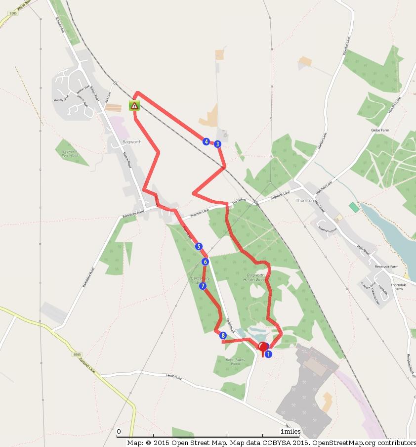
8 8 / 8
U3A WALK Harby Hose. Route Summary. Route Overview. Description. Waypoints. Harby. Stuart Galloway
 U3A WALK Harby Hose Stuart Galloway Route Summary A circular walk taking in Harby, Hose and the Grantham Canal. Route Overview Category: Walking Length: 7.310 km / 4.57 mi Parking: Village Hall School
U3A Markfield and Hill Hole Quarry
 U3A Markfield and Hill Hole Quarry Stuart Galloway Route Summary Circular walk around Markfield including Hill hole quarry and the Altar Stones Route Overview Category: Walking Length: 5.570 km / 3.48
U3A WTT Mountsorrel Circular
 U3A WTT Mountsorrel Circular Stuart Galloway Route Summary A circular walk around Mountsorrel taking in a visitors centre at Mountsorrel Station, part of the Great Central Railway heritage railway. Also
A Circular Walk from Chapel Carn Brea
 A Circular Walk from Chapel Carn Brea 4.3 Miles A Walk Visiting Five Historic Ancient Sites This circular walk offers the possibility of several alternatives, depending on the walker s available time and
The Great Malvern Town Centre Walk. The Great Malvern Alternative Town Centre Walk
 The Great Malvern Alternative Town Centre Walk This is an abridged version of walk 4, from the Pictorial Guide to the Malvern Hills Book Two: Great Malvern Available from the Tourist Information Centre,
The Mendip Way. Route Directions and Maps Uphill to Wells
 The Mendip Way Route Directions and Maps Uphill to Wells Website: www.mendiphillsaonb.org.uk Email: mendip@mendiphillsaonb.org.uk Facebook & Twitter: @MendipHillsAONB Phone: 01761462338 1 Uphill to Loxton
Walking in my Fore father's Footsteps
 Walking in my Fore father's Footsteps by Victor T.D. Holliday As part of the introduction to Local Mining History it falls upon me to undertake research that reflects my personal interest in mining history.
Beamers Trail. Walk No.1. 6 miles. (easy with some moderate ascents and descents)
") Beamers Trail Walk No.1 6 miles (easy with some moderate ascents and descents) 1 BEAMERS TRAIL 6 miles (easy with som WALK The Warpers Trail forms part of the long distance Witton Weavers Way. This is
Beamers Trail Walk No.1 6 miles (easy with some moderate ascents and descents) 1 BEAMERS TRAIL 6 miles (easy with som WALK The Warpers Trail forms part of the long distance Witton Weavers Way. This is
WALKS AROUND WOODHURST
 WALKS AROUND WOODHURST With Walks To Woodhurst from North St. Ives Woodhurst is situated on the verge of an elevated tract of table land four miles north of St. Ives. Its footpaths vary from leafy lanes
Tacklers Trail. Walk No miles. (A walk with a couple of short steep slopes and some rough moorland paths)
") Tacklers Trail Walk No.3 9.5 miles (A walk with a couple of short steep slopes and some rough moorland paths) WALK 3 TACKLERS TRAIL 9.5 miles (moderate wi 1. Sunnyhurst Visitor Centre The Warpers Trail
Tacklers Trail Walk No.3 9.5 miles (A walk with a couple of short steep slopes and some rough moorland paths) WALK 3 TACKLERS TRAIL 9.5 miles (moderate wi 1. Sunnyhurst Visitor Centre The Warpers Trail
BURGHCLERE PARISH RIGHTS OF WAY
 BURGHCLERE PARISH RIGHTS OF WAY Full descriptions compiled by Neill & Miggie Bruce All photos Miggie Bruce FP23 on Ridgemoor, looking south, with FP22 crossing by the bush FP1. From C183 Aldern Bridge
Hay Wood, Rowington and Baddesley Clinton - Warwickshire
 Hay Wood, Rowington and Baddesley Clinton - Warwickshire Starts at Lay-by alongside Hay Wood 2 hours 30 minutes 5.5miles 8.8km Leisurely ID: 0.683 Developed by: John Clift Checked by: Andy Page www.ramblersroutes.org
3.1 Bowness-on-Solway to Carlisle
 3.1 Bowness-on-Solway to Carlisle Map panel 1 Distance 15 miles (24 km) Terrain minor roads, tracks, field paths and riverside footpath, muddy in places Grade easy, with gentle gradients on undulating
There are many information panels hidden between the buildings and the newer ones are made of brick. The old medieval structures are made from stone.
 There are many information panels hidden between the buildings and the newer ones are made of brick. The old medieval structures are made from stone. The monk sculpture is near the woodland but also has
BISHOPSTONE CIRCULAR WALK
 BISHOPSTONE CIRCULAR WALK 4½ miles (7¼ km) - allow 2 hours (see maps on final pages) Introduction This walk is within the North Wessex Downs Area of Outstanding Natural Beauty and starts from the small,
Ardingly Lake, Ouse Valley, Borde Hill
 point your feet on a new path Ardingly Lake, Ouse Valley, Borde Hill Distance: 14 km=9 miles or 12½ km=8 miles Region: West Sussex Author: Hautboy Refreshments: Borde Hill Map: Explorer 135 (Ashdown Forest)
3 Map showing Clipstone While many people will have heard of Mansfield, not everyone is aware where Clipstone is.
 Presentation made by Pauline Marples at the CBA East Midlands Home Front Legacy Day School on 3 October- Notes to accompany the slides both reproduced here with kind permission from Pauline. Clipstone
START - UPHILL BEACH. (tidal!) The West Mendip Way is route-marked with these round blue signs
 The West Mendip Way is route-marked with these round blue signs") START - UPHILL BEACH Start Times: 10:30 11:15 12:00 Please allow sufficient time to check in with the marshals Start on the beach at the high water line (tidal!) The West Mendip Way is route-marked with
START - UPHILL BEACH Start Times: 10:30 11:15 12:00 Please allow sufficient time to check in with the marshals Start on the beach at the high water line (tidal!) The West Mendip Way is route-marked with
Aston Rowant Discovery Trail
 The walk was developed by Aston Rowant Parish Council. The Trail is stile-free and fully way-marked. The circular route is 5.3m but with the extension to a pub and hotel 6.2m. Key Main Aston Rowant Discovery
Slad over to Pitchcombe and back
 The walk climbs up from Slad over Wickridge Hill, descends to near Pitchcombe, then climbs back over Wickridge hill and round the back of Slad. Page 1 Start Point: SO 8718 0732 The Woolpack, Slad Length:
A brief history of Embleton and Wythop. by Walter Head and Derek Denman Embleton Community Hall, 15 April
 A brief history of Embleton and Wythop by Walter Head and Derek Denman Embleton Community Hall, 15 April 2015 1 Structure of presentations Derek Denman: An outline of the history of Embleton and Wythop
Bewl Water & the High Weald
 1 Bewl Water & the High Weald Stonegate station - Stonegate - Wallcrouch - Newbarn - Cousley Wood - Wood's Green - Wadhurst station Length: 9 ½ miles (15.3km) Underfoot: Large portions of this path are
Riverside. Riverside Heritage Trail. Heritage Trail STRATFORD-UPON-AVON STRATFORD-UPON-AVON. Stratford Historic Buildings Trust. Further information
 STRATFORD-UPON-AVON Riverside Heritage Trail Further information Websites stratfordhbt.co.uk stratfordsociety.co.uk shakespeare.org.uk STRATFORD-UPON-AVON Riverside Heritage Trail Books The Buildings of
Britain s oldest surviving water-balanced cliff lift
 44 3.6 Saltburn by the Sea to Sandsend Map panels 3 and 4 Distance 17 miles (27½ km) Terrain mostly grass and field paths which can be muddy; some pavement, beach and shore Grade undulating route, with
THE BUILDING OF SUTTON PLACE. SIR RICHARD WESTON S GRAND DESIGN.
 A lot THE BUILDING OF SUTTON PLACE. SIR RICHARD WESTON S GRAND DESIGN. Iain Wakeford 2014 of people refer to Sutton Place, Guildford but the house (and indeed the village of Sutton Green) is firmly in
Welcome to Windsor Castle. Introducing you to the Learning Centre, the State Apartments and the Castle Precincts
 WINDSOR CASTLE Welcome to Windsor Castle Introducing you to the Learning Centre, the State Apartments and the Castle Precincts When you arrive on the morning of your visit The coach will drop you on the
Eastbourne. Alfriston 3¾ 6 3¾ 6. Birling Gap. Exceat
 3.8a Alfriston to Eastbourne (footpath) Map panel 6 (page 64) Distance 10½ miles (17 km) Terrain valley walk initially, first along riverbank path then hillside paths above, including stretch through forest;
As pretty as a picture
 43 As pretty as a picture Discover this enchanting stroll through classic Kentish countryside and peaceful Plaxtol. Shipbourne Village Green 44 44 Shipbourne Crown copyright 0009238. St Giles Church Location:
Chevening and the North Downs
 1 Chevening and the North Downs Dunton Green station - Chipstead - Chevening - Knockholt - Hawley's Corner - Botley Hill - Oxted station Length: 12 ¼ miles (19.7 km) Underfoot: Portions of the walk are
landcapes and romance Artists and poets have been inspired by the idyllic scenes of picturesque Kent villages sheltered by rolling, chalk hills.
 landcapes and romance Artists and poets have been inspired by the idyllic scenes of picturesque Kent villages sheltered by rolling, chalk hills. WALK 4 41 41 WALK 4 42 Pond Location: Distance: 5 miles
Approximate distance: 7.5 miles For this walk we ve included OS grid references should you wish to use them.
 Approximate distance: 7.5 miles For this walk we ve included OS grid references should you wish to use them. 6 5 7 8 4 1 2 Start End N 3 W E S Reproduced by permission of Ordnance Survey on behalf of HMSO.
This path goes past an old tree nursery and sawmill. After 800m it crosses over a lane. Follow the bridleway fingerpost into the woods.
 FRENSHAM PONDS 11K CIRCULAR TRAIL 2½ HRS GU10 2DA This magnificent heathland trail starts in woodland and then brings you out onto the open heather of Frensham Common, with no roadwork! The route runs
Inchcailloch Island. Cultural Heritage. Welcome to the island of Inchcailloch.
 Inchcailloch Island. Welcome to the island of Inchcailloch. There are two walking routes on the island the Low Path and the Summit Path. They can be enjoyed separately or together. Each path takes 30-45
Leaden Boot Challenge ROUTE INSTRUCTIONS
 Leaden Boot Challenge ROUTE INSTRUCTIONS Section 1 Alstonefield to Ilam From the village hall car park turn R then L and pass through the village keeping to the R to enter Church Street. Pass the Church
Aira Force & Ullswater Access Statement
 Aira Force & Ullswater Access Statement Aira Force, Watermillock, Penrith, CA11 0JS T: 017684 82067 E: ullswater@nationaltrust.org.uk Section 1: Aira Force Section 2: Ullswater Countryside Section 1: Aira
Morning Copse near Maidstone, Kent acres of Ancient Woodland with a pond, bluebells and mature oak. 26,500 (freehold)
") WOODS 4 SALE Phone: 01248 364 362 www.woods4sale.co.uk UK Woodland & Woods For Sale: Specialising in the Sales of Small Woodlands in England, Scotland and Wales for Recreation, Wildlife Conservation and
WOODS 4 SALE Phone: 01248 364 362 www.woods4sale.co.uk UK Woodland & Woods For Sale: Specialising in the Sales of Small Woodlands in England, Scotland and Wales for Recreation, Wildlife Conservation and
Approximate distance: 4.5 miles For this walk we ve included OS grid references should you wish to use them. Start. End
 Approximate distance: 4.5 miles For this walk we ve included OS grid references should you wish to use them. 2 1 Start End 4 3 N W E S Reproduced by permission of Ordnance Survey on behalf of HMSO. Crown
Pen Cerrig-calch prehistoric cairns
 Walk Information: Maps: OS Explorer OL13 Distance: 8 miles / 13 kilometres Duration: Allow at least 6 hours for the circular walk Difficulty: medium. Some narrow paths, occasionally rough underfoot Start
Weatherman Walking Welshpool Approximate distance: 4 miles Start End
 Approximate distance: 4 miles For this walk we ve included OS grid references should you wish to use them. 4 3 2 1 Start End 5 6 N W E S Reproduced by permission of Ordnance Survey on behalf of HMSO. Crown
A leisurely one mile stroll through the history of Aldershot s Manor park, considered by many as the most attractive and pleasant parts of our town.
 Figure 1 Entrance to Park from the Aldershot Green/Churchill road end A leisurely one mile stroll through the history of Aldershot s Manor park, considered by many as the most attractive and pleasant parts
Fetcham Downs and Bocketts Farm A magical teashop walk
 point your feet on a new path Fetcham Downs and Bocketts Farm A magical teashop walk Distance: 3 km=2 miles or 4 km=2½ miles Region: Surrey Author: Fusszweig Refreshments: Bocketts Farm easy walking Date
Hadleigh Castle and Chalkwell Oaze
 1 Hadleigh Castle and Chalkwell Oaze Benfleet station Hadleigh Park Hadleigh Castle Leigh-on-Sea Chalkwell station A short stroll through the lush woods of Hadleigh Park high above the Thames-side marshes,
West Wirral (Dee Estuary)
") View of Hilbre Island from West Kirby with walkers at low tide. West Wirral (Dee Estuary) West Kirby is the start of the 12 mile long Wirral Way, the backbone of Wirral Country Park, the old Hooton to
View of Hilbre Island from West Kirby with walkers at low tide. West Wirral (Dee Estuary) West Kirby is the start of the 12 mile long Wirral Way, the backbone of Wirral Country Park, the old Hooton to
Hetton-le-Hole Herald
 Hetton-le-Hole Herald The Newsletter for Hetton Local History Group Volume.1... Issue..3... Date..February 2010... Summary Part 2 of the Halls of Hetton looks at Eppleton Hall and Hetton Hall. The latter
2. 1 Glendalough. Monastic City
 2. 1 Glendalough 20 Glendalough s Monastic City was founded in the seventh century in honour of St Kevin. It became a magnet for pilgrims for over a thousand years. The artist's impression below shows
Walk 1. Cotswold Water Park. Gateway Centre to Cerney Wick, railway track to Lake 6, Gateway Centre.
 Cotswold Water ark Walk way A Swindon/ Cirencester Thomas and Severn Canal way to Cerney Wick, railway track to Lake, way. Spine Road East Hotel Time: hours (short walk km) Distance: km A level walk along
Friends Meeting House, Leicester. 16 Queens Road, Leicester, LE2 1WP. National Grid Reference: SK Statement of Significance
 Friends Meeting House, Leicester 16 Queens Road, Leicester, LE2 1WP National Grid Reference: SK 59852 02815 Statement of Significance A meeting house purpose-built on a new site in 1955 and slightly enlarged
The Castor Roman Walk
 The Castor Roman Walk Welcome to the Route Plan and teachers notes for the Castor Roman Walk. The walk is approximately 3km, with an optional extension of 0.7km. We suggest that you bring with you OS Explorer
Horden. A walk of nature...sea and history
 Horden A walk of nature......sea and history 182 283 A181 Wingate B1287 Peterlee Seaham Easington B1281 Newcastle Horden Blackhall A179 Newcastle International Airport Crimdon A1086 Location... Horden
The Hallams Blackheath Surrey
 The Hallams Blackheath Surrey The Hallams Littleford Lane Blackheath Surrey An exceptional opportunity in a stunning rural position Land: In all about 5 hectares (12.4 acres) Buildings: In all about 1,385
Much of the information which follows is included by kind permission of the Tynedale Council (now defunct) and is based on its brochure.
 and is based on its brochure.") The Tyne Green Trail This easy going circular walk is on level ground throughout. It follows the course of the River Tyne between Hexham Bridge and the turning point just past Watersmeet. The return is
The Tyne Green Trail This easy going circular walk is on level ground throughout. It follows the course of the River Tyne between Hexham Bridge and the turning point just past Watersmeet. The return is
Lane Head, St James Square & Bridge Street
 Lane Head, St James Square & Bridge Street Standing at the junction of Lanehead Lane was one of Bacup s oldest hostelry s when it was demolished in 1931, the Angel Inn Hotel. Unlike today Lane Head Lane
North Wales Miners Association Trust Ltd Wrexham South Mine Trail
 North Wales Miners Association Trust Ltd Wrexham South Mine Trail An 18 mile circular trail by car or bike, passing features relating to the local coal, lead and iron industries. Note that some of the
Walk 1: Highfield, Lob Wood and The River Wharfe
 Walk 1: Highfield, Lob Wood and The River Wharfe Start: The Hen Pen Garden, Main Street, Addingham LS29 0NS, SE 077 498. Alternative Start: Near Bolton Bridge SE 071 525 (see page 6). Full walk: 4.5 miles
Newlands Corner Leaflet 08:Newlands Corner Leaflet 5/10/09 11:58 Page 1
 Newlands Corner Leaflet 08:Newlands Corner Leaflet 5/10/09 11:58 age 1 St Martha s is the start of the Downs Link, a 33-mile long distance trail linking the North Downs Way with the South Downs Way at
Just under a mile from Cawfields car park where the walk begins is Great Chesters Roman Fort. It is behind the tree, looking from the west.
 Tynedale U3A Hadrian s Wall Group Cawfields to Birdoswald Just under a mile from Cawfields car park where the walk begins is Great Chesters Roman Fort. It is behind the tree, looking from the west. Great
The. History Walk. WWII Armaments factory
 The History Walk WWII Armaments factory 4.8-6.5 kilometres (3-4 miles) 2.5-3.5 hours Terrain: easy Can be slippery when wet No stiles Unsuitable for a pushchair/wheelchair Uses OS map 197 Parking: Pulborough
The History of Rock Cottage, Westfield Road, Horbury circa
 The History of Rock Cottage, Westfield Road, Horbury circa 1860-1960. This is the history of a dwelling known in its day as Rock Cottage which was situated on Denton Lane (now Westfield Road) in Horbury
PHOENIX PARK INCORPORATING THURNSCOE COMMUNITY WOODLAND
 PHOENIX PARK INCORPORATING THURNSCOE This popular site is known for its sculptures and climbing wall which can be seen as you meander around the park. Walking towards the top of the woodland you will pass
Coast Path Survey Stretch 09 Shalfleet Mill to Thorness Bay
 Coast Path Survey Stretch 09 Shalfleet Mill to Thorness Bay Overview Map of stretch Introduction This stretch of Island coast covers several salt marsh creeks backed by grazing land and woodland on the
Beautiful Walks from the Blue Ball Inn
 Walk No. 5 RIVER VALLEYS AND MOOR Countisbury, Watersmeet, Hillsford Bridge, Cheriton, Shilstone Hill, Rockford and Chiselcombe. 8.5 MILES APPROX. Walking time four and a half hours approx. OS 1;25,000
Friends Meeting House, Hitchin. 1 Paynes Park, Hitchin, Hertfordshire, SG5 1EH. National Grid Reference: TL Statement of Significance
 Friends Meeting House, Hitchin 1 Paynes Park, Hitchin, Hertfordshire, SG5 1EH National Grid Reference: TL 18282 29279 Statement of Significance A meeting house of 1957 designed by Paul V. Mauger and erected
Beautiful Walks from the Blue Ball Inn
 Walk No. 2 WINSTONS WALK Countisbury, Wind Hill, Watersmeet, Ash Bridge and Winston s path. 5 Miles approx. Walking time- Two and a half hours approx. (Not including Breaks) OS 1:25,000 Sheet 64/74 Lynton
Crimdon. A walk of nature...sea, sand and countryside
 Crimdon A walk of nature......sea, sand and countryside A182 B1283 A181 Wingate B1287 Peterlee Seaham Easington B1281 Newcastle Horden Blackhall A179 Newcastle International Airport Crimdon A1086 Location...
Baslow & Bubnell Page 1 of 5 A Comparison
 Baslow & Bubnell Page 1 of 5 Introduction This paper describes the number of houses in Baslow and Bubnell from 1670 up to the present day. Most of the data was obtained by counting the buildings on a series
Ystwyth and Rheidol Bridleway Routes. Route 2:Llanilar Circular
 Ystwyth and Rheidol Bridleway Routes Route 2:Llanilar Circular Route overview and terrain: A long circle using connecting ridges with fine views to link the Rheidol and Ystwyth river valleys. The route
Woodland Walk If you enjoyed this walk there are two others available in the same area.
 The Woodland Walk 11-12 kilometres (7-8 miles) 4-5 hours Terrain: some easy hills Can be slippery when wet 5 stiles Unsuitable for a pushchair/wheelchair Uses OS map 197 Parking: Pulborough Station and
CWMGIEDD FROM ABERCRAVE
 Abercrave to Cwmgiedd Walk Page 1 Starting from The Abercrave Inn. Grid Ref: SN 824128 From the Abercrave Inn, an 11.3km (7 miles) walk to the foothills of the Cribarth Mountain, then through forest to
Pontfadog. Walk A. Walk A
 Walk A A Bird s eye view of the village 2km. (1 1 /2 miles); height gain 45m. (150ft) about 45 minutes. Six minutes walk along the main road towards Glyn Ceiriog reach a signpost to Llwynmawr. Take the
SHEEPLEAS. Visitor Guide and Self-guided Trails
 SHEEPLEAS Visitor Guide and Self-guided Trails Sheepleas The Sheepleas is an interesting mix of woodland, scrub and open grassland, situated on the chalk of the North Downs. This diversity of habitats
Blue House Farm MATTINGLEY, HAMPSHIRE
 Blue House Farm MATTINGLEY, HAMPSHIRE Blue House Farm BOTTLE LANE, MATTINGLEY, HAMPSHIRE Farmhouse set in the centre of approximately 96 acres with extensive equestrian and agricultural buildings including
East Midlands Region LEICESTER 3/16 (E.62.A010) SK
 SK") LEICESTER City of Leicester 3/16 (E.62.A010) SK 5853 0433 12 NEW ST., CASTLE WARD, LEICESTER Cottage to the Rear of 12 New St., Castle Ward, Leicester - A Photographic Survey and Archaeological Watching
LEICESTER City of Leicester 3/16 (E.62.A010) SK 5853 0433 12 NEW ST., CASTLE WARD, LEICESTER Cottage to the Rear of 12 New St., Castle Ward, Leicester - A Photographic Survey and Archaeological Watching
From castle to county town
 From castle to county town A self guided walk around Warwick Explore how Warwick has developed over the last thousand years Visit the town s historic landmarks and hidden treasures Find out how the streets
The History of the Country Houses of Leicestershire and Rutland
 books from to Home Page 7 PART 1 The History of the Country Houses of Leicestershire and Rutland What is an historic Country House? At first sight, the definition of an historic Country House may seem
Leaden Boot Challenge 2016 ROUTE INSTRUCTIONS
 Leaden Boot Challenge 2016 ROUTE INSTRUCTIONS Section 1 Alstonefield to Ilam (CP2) From the village hall car park turn R then L and pass through the village keeping to the R to enter Church Street. Pass
Lancaster Castle THE CASTLE STUDIES GROUP JOURNAL NO 26:
 Lancaster Castle. The Henry IV gatehouse from the south-east. The C15 gatehouse subsumes a C12/13 stone gateway, observable inside the gate passage beyond the portcullis. The lower level loops originally
Basingstoke Canal and Dogmersfield
 point your feet on a new path? Basingstoke Canal and Dogmersfield Distance: 11 km=7 miles easy ing or 2 s of 7½ km=4¾ miles and 5¼ km=3¼ miles Region: Hampshire Author: Botafuego Refreshments: The Barley
Blackhall Colliery and Village History
 Blackhall Colliery and Village History by Dru Trenholm Early History People had lived in the Blackhalls area for centuries. Neolithic Stone Age settlements were near Dene Holme, Crimdon Dene, in an area
The Bridestone Rocks from Lydgate
 Print this page Back to results The Bridestone Rocks from Lydgate Ancient tracks and gritstone outcrops, with terrific views of the steepsided Cliviger Valley. Distance 5 miles (8km) Minimum time 2hrs
MP : The Big Chief Overlook and the Glen
 MP 253 254: The Big Chief Overlook and the Glen The mile between MP 253 and 254 has lots of history in it. It includes the only recorded remains of the Victory Highway on the Clear Creek County side of
walking
 Two Castles Trail Meander through rolling countryside full of history on this 24 mile waymarked walking route between Okehampton and Launceston Castles www.devon.gov.uk/ walking www. dartmoor.co.uk www.
English Country Church Calendar 2008 Continental visitors famously referred to England as the ringing island as you were never out of earshot of
 English Country Church Calendar 2008 Continental visitors famously referred to England as the ringing island as you were never out of earshot of church bells. There are of course the well-known great churches
Brick House MAMHEAD EXETER DEVON
 Brick House MAMHEAD EXETER DEVON Brick House MAMHEAD EXETER DEVON A magical Grade II* listed house with planning to dramatically improve if required, with its own vineyard Accommodation and amenities
Lordenshaw. What are cup & ring marks?
 Lordenshaw Lordenshaw hill has one of the largest clusters of ancient cup and ring marked stones in the UK. We ve chosen four interesting spots we d like to share with you. What are cup & ring marks? The
The Hundred Parishes
 The Hundred Parishes Walks from railway stations number 3 3 miles (5kms) circular walk from Stansted Mountfitchet Start & finish: Stansted Mountfitchet station. Ordnance Survey Explorer Map 195. Grid Reference:
Science and Nature Group Building Stones in Stratford-upon-Avon, Friday 12 th April 2013
 Science and Nature Group Building Stones in, Friday 12 th April 2013 A very good sized group met in the churchyard of Holy Trinity to walk around to view the various building stones used around the town.
The Sudbury Branch Walks 1-4
 The Sudbury Branch Walks 1-4 Sudbury Branch Walks From Sudbury to Marks Tey The gentle declivities, the luxuriant meadow flats sprinkled with flocks and herds... the sound of water escaping from the mill
Spa Walkers Health Walk 6 Vines Park. A History & Heritage Walk
 Spa Walkers Health Walk 6 Vines Park. A History & Heritage Walk Starts at Droitwich Spa Leisure Centre. 49 minutes 2.5miles 4.1km Easy ID: 0.4070 Developed by: Mike Skan www.ramblersroutes.org A walk on
Register of Parks and Gardens of Special Historic Interest in England. The first publicly owned park in Bradford, open in early 1850s.
 Register of Parks and Gardens of Special Historic Interest in England West Yorkshire Bradford Bradford Peel Park GD3330 II The first publicly owned park in Bradford, open in early 1850s. Historic Development
Reigate Hill and Gatton Park
 point your feet on a new path Reigate Hill and Gatton Park Distance: 11½ km=7 miles easy-to-moderate walking or 2 walks of 6½ km=4 miles and 5½ km=3½ miles Region: Surrey Author: Schwebefuss Refreshments:
Lewes and the South Downs
 point your feet on a new path and the South Downs Distance: 0 km=1½ miles moderate walking with long easy stretches Region: East Sussex Author: Hautboy Refreshments: Date written: 8-apr-013 Map: Explorer
Skipton Castle Woods Accessibility Statement November 2016
 Skipton Castle Woods Accessibility Statement November 2016 Purpose: This accessibility statement outlines the available facilities and access information for Skipton Castle Woods. Welcome We, the Woodland
The Don Gorge A Landscape reclaimed by nature
 The Don Gorge A Landscape reclaimed by nature Walk summary: A walk taking in historical and natural features of the Don Gorge, including Sprotbrough weir and fish pass, the lost village of Levitt Hagg,
Baggy Point, Croyde, North Devon
 Baggy Point, Croyde, North Devon A walk using the South West Coast Path that is likely to be suitable for people with impaired mobility or with a pushchair, wheelchair, or mobility scooter. The Coast Path
Hindhead, Keffolds Copse and Gibbet Hill
 point your feet on a new path, Keffolds Copse and Gibbet Hill Distance: 6 km=4 miles Region: Surrey Author: Schwebefuss Refreshments: Punch Bowl Café moderate walking Date written: 14-apr-2015 Last update:
Medway Valley Orchards
 1 Medway Valley Orchards East Farleigh station - Kettle Corner - Farleigh Green - Buston Manor - Yalding - Yalding station Length: 6 ¾ miles (10.9km) Underfoot: Generally, this is a walk on good paths,
No 2 Ketts height WalK
 Pub Walks around Norwich No 2 Ketts height WalK Introduction This second walk, which like the first is circular, also starts and ends at Norwich (Thorpe) Railway Station but takes in a very different part
Orchards and oasts a taste of the Garden of England
 49 Orchards and oasts a taste of the Garden of England Open parkland, orchards, oasts and incredible panoramic views over the Weald to the South Downs make this a truly memorable walk. Linton Village 50
The fascinating history around the Legend of Richard Burton
 INSPIRING LANDSCAPES FASCINATING HISTORY & LEGEND GREAT WALKS IN AFAN FOREST PARK Walk the trail in memory of the legend of Richard Burton including a historic exploration of his birthplace village The
St. Paul's Cathedral. Identification. Location EBN Construction Type
 +49 40 6094 6494 0 +1 250 483 7089 Identification EBN 110679 Name Construction Type Current Status church existing [completed] Location Continent Name Europe Postcode EC4 Country Name United Kingdom Address