From castle to county town
|
|
|
- Trevor Casey
- 5 years ago
- Views:
Transcription


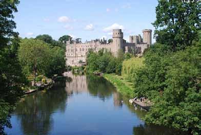
1 From castle to county town A self guided walk around Warwick Explore how Warwick has developed over the last thousand years Visit the town s historic landmarks and hidden treasures Find out how the streets and buildings have evolved Discover how town planning shapes the future and preserves the past the stories of our landscapes discovered through walks
2 2
3 This booklet is to be used alongside the audio commentary for this walk Contents Introduction 4 Route overview 5 Practical information 6 Directions 8 Credits 13 Further information 14 The Royal Geographical Society with the Institute of British Geographers, London, 2011 Discovering Britain is a project of the Royal Geographical Society (with IBG) The digital and print maps used for Discovering Britain are licensed to the RGS-IBG from Ordnance Survey 3


4 From castle to county town The fascinating story of Warwick s development In any town or city, your attention is usually taken by historic monuments, beautiful architecture or spectacular buildings. But how often do you take notice of the basic urban fabric of roads, bridges, paths, walls, houses and gardens? This walk in Warwick, led by a local town planner, explores the things you would usually miss. It tells a story of how this settlement has developed over the last thousand years from being the chosen site for a castle to a busy county town. Thomas Oken s House Martin Haslett RGS-IBG Discovering Britain Warwick Castle Rory Walsh RGS-IBG Discovering Britain See changes in housing styles and construction materials through the centuries and learn how a dramatic fire led to new building regulations. Observe how the busy town centre continues to operate within a medieval street layout. Find out how the ownership of land and building use have changed over time. Visit the town s civic treasures as well as lesserknown corners. This walk tells a fascinating story of urban development and gives new insights into a stroll around this picturesque town. 4

5 Route overview Stopping points St Nicholas Park Bridge over River Avon Bridge End Mill Street Gateway to Warwick Castle Castle Lane Westgate Lord Leycester Hospital Hill Close Gardens Market Place St Mary s Church Northgate House Victoria Street Former gasworks, Saltisford Former Leper Hospital, Saltisford Priory Park Tink-a-Tank High Street / Jury Street / Church Street crossroads Eastgate St John s House 5
6 Practical information Location Getting there Start point Directions from railway station to start Finish point Onward journey Warwick, West Midlands Train - the nearest station is Warwick but Warwick Parkway is also nearby. Both stations are served by trains running between London Marylebone and Birmingham Snow Hill. Car - Warwick is close to Junctions 13 to 15 of the M40 between London and Birmingham. Also easily accessed from the A46 near Coventry. There are 14 town car parks (charges apply). On Sundays parking is free of charge at Priory Road, Barrack Street, West Rock and St Marys. Bus - local bus operators connect with Leamington Spa, Coventry, Stratford-upon-Avon and Rugby. Warwick bus station is in the town centre. St Nicholas Park, CV34 4QY From Warwick station turn left and follow Station Road downhill then turn right onto Coventry Road. At the end turn right and use the traffic lights to pass St John s House. Bear left into St Nicholas Church Street. At the roundabout keep left and follow the church wall into St Nicholas Park. With the car park on your left continue to the pavilion on the right. St John s House, CV34 4NF The route is almost circular, finishing on the opposite side of St Nicholas Park. To retun to Warwick station, use the traffic lights to cross the road and turn left into Coventry Road. Then take Station Road on the left. 6
7 Distance Level Conditions Suitable for Refreshments Facilities Places to visit Tourist information 3 ½ miles Gentle a town centre route with some hills As an historic town centre, Warwick can get busy at weekends and in the tourist season. Take care for traffic, especially at the busy junctions of Westgate (Stop 7) and Eastgate (Stop 19). There are some slopes on the walk and some pavements are very narrow Families family friendly route but some busy roads Wheelchairs there are steps at Warwick Castle (Stop 6); alternative route available There are many cafes, pubs and restaurants in the town centre, including: - Thomas Oken Tea Rooms (at Stop 6) - Lord Leycester Hospital café (Stop 8) - the Market Place (Stop 10) Public toilets in St Nicholas Park (Stop 1) and the town centre Warwick Castle is open daily from 10am. Closing time varies throughout the year, usually 5 or 6pm. Adult tickets 30.60, children 25.80, concs 27. Advance booking reductions. (Tel: Mon-Fri only) Warwick Tourist Information Centre, The Court House, Jury Street, CV34 4EW (Tel: ) 7
8 Directions These directions are for use with the Warwick walk audio commentary. Listen to each track then read the directions below to get to the next stop. 1. Welcome to Warwick St Nicholas Park Directions 1 From St Nicholas Park, make your way to the gates at Banbury Road. Cross over using the pelican crossing and turn left. When you reach the bridge over the river, look at the view of the Castle and listen to Track The finest view in England! Bridge over River Avon Directions 2 Continue over the bridge. At the roundabout, turn tight and go down Bridge End. Follow the road to for about 250 metres. Where it bends to the left, stop and listen to Track Bridge End a road with no bridge! Bridge End Directions 3 When you are ready, retrace your steps back over the bridge. Continue up Banbury Road to the roundabout. Ahead of you is the Castle gateway. Turn left down Mill Street. Walk down to the end of Mill Street under the castle walls and listen to Track A fine medieval street Mill Street Directions 4 Retrace your steps back up Mill Street. Stop in front of the castle gateway and listen to Track 5. 8
9 5. The ruins restored Gateway to Warwick Castle Directions 5 Go through the Castle gateway and follow the driveway. At the gates you can stop to see inside the castle. Go up the steps to the right of the gates. Continue along here with the castle entrance on the left and a car part on the right. When you reach Castle Lane, turn left. Stop at the end where it meets Castle Street and listen to Track 6. Step-free directions - Facing the Castle gateway take the road to the right, which is Castle Hill, keeping the castle walls on the left. Then take the first turning left into Castle Lane. Go to the end where it meets Castle Street and listen to Track A civic bargain Castle Lane Directions 6 Turn left and follow Castle Road around, keeping the castle walls on your left. At King s Lodge, turn right into Leycester Place. At the end, turn left down the hill. Cross over the traffic island. Take care as this can be a busy road. Make your way back up the hill towards the Westgate tower. When you are beneath the tower, listen to Track Medieval gates Westgate Directions 7 Go up through Westgate. Take your time to look at the stonework. At the top of the slope, turn back on yourself into the cobbled area outside the Lord Leycester Hospital. Go through the stone arch and listen to Track A grand home for retired servicemen Lord Leycester Hospital Directions 8 Retrace your steps back down through Westgate then turn right into Bowling Green Street. Cross the road at the pedestrian crossing opposite the school. Turn left into Hill Close Gardens at the side of the school. A sign says private property but this is actually a public right of way. Walk past the garages and stop at the railings at the far end overlooking Hill Close Gardens where you can listen to Track 9. Feel free to visit the garden afterwards by going down the steps on the left and following the path. 9
10 9. Green fingers Hill Close Gardens Directions 9 When you are ready, retrace your steps through the car park and back onto Bowling Green Street. Turn left and cross over at the pedestrian crossing and then follow the road that sweeps to the left to Market Place. Once in the Market Square, stop outside the Market Hall and listen to Track Fire! Market Place Directions 10 Walk up Market Place with The Tilted Wig pub on the right. At the top, turn right. Stop outside the church and listen to Track Relief and rebuilding St Mary s Church Directions 11 From the church, walk along Northgate Street. At the end of the street, stop before the small roundabout and listen to Track A new set of rules Northgate House Directions 12 Cross over safely to Northgate House and turn left down Saltford. At the next roundabout, keep right on the main road. When you reach the Black Horse Inn, turn right into Victoria Street and listen to Track You could be in Birmingham! Victoria Street and Albert Street Directions 13 Go back to the Black Horse Inn and turn right along Saltisford. Don t forget to look up Albert Street, which is the next road on the right. Continue a short way further until you reach a large building opposite The Antelope pub and listen to Track
11 14. Illumination Gasworks Directions 14 Continue along the road. Shortly after a junction with traffic lights, you will reach a small stone building. Stop here and listen to Track A home for outcasts The Leper Hospital Directions 15 Retrace your steps back into town, past the gas works and up the hill to Northgate House. Turn down Cape Road at the side of Northgate House. Cross over and enter Priory Park by the signboard. Walk fairly straight into the park through the trees and stop on the flat grassy area, where you can listen to Track A little piece of Warwick in the USA Priory Park Directions 16 Retrace your steps out of the park the way that you came in. At the top of Cape Road, cross over and turn left. Take the road down the right hand side of the Punch Bowl pub. After the car park on the right hand side, find an alley running between high stone walls. Stop in the alley and listen to Track The path with a strange name Tink-a-Tank Directions 17 Continue along the alley and the back of St Mary s Church until you reach Church Street. Turn left into Church Street and go down to the crossroads with Jury Street, where you can listen to Track An exception to the rule High Street/Jury Street/Church Street crossroads Directions 18 Turn left down Jury Street and continue to the end. Cross over to the Eastgate in front of you. Stop by the pillar box and listen to Track
12 19. A private house with battlements East Gate and Smith Street Directions 19 Go through the Eastgate and continue down Smith Street. At the bottom, cross to the right hand side using the two pelican crossings. Continue along the right hand side of St John s with a stone wall on your right. Stop when you reach the gates of St John s House go in if they are open and listen to Track A fine appearance St John s House Directions 20 To return to St Nicholas Park where the walk started you can go round the left side of St John s House (if the grounds of are open) and through the gardens. If the House is closed retrace your steps along St John s, bear left along St Nicholas Church Street, go left at the roundabout and the park entrance is on your left. To return to the town centre retrace your steps along St John s and up Smith Street. To got to to the railway station, cross over St John s, bear left up Coventry Road and after about 200 metres bear left into Station Road. 12
13 Credits The RGS-IBG would like to thank the following people and organisations for their assistance in producing this Discovering Britain walk: Martin Haslett for creating the walk and providing photographs Jenny Lunn for editing the walk materials Rory Walsh for taking photographs and compiling walk resources Caroline Millar for editing the audio commentary Nick Stanworth and Florence Lee for additional assistance with compiling walk resources Ted Hatch for drawing a beautiful map of the extent of the Great Fire of Warwick Leamington Spa Art Gallery & Museum and the The Warwickshire Photo Gallery for kind permission to use archive images Jonathan Webb for his aerial photograph of Warwick Castle 13
14 Further information Find out more about the walk story and places of interest along the route The Brethrens Kitchen Enjoy Warwick Enjoy Warwickshire Hill Close Gardens The Lord Leycester Hospital lordleycester.com Thomas Oken Tea Rooms Warwick Castle Warwickshire Farmers Market 14
15 15


16 Britain s landscapes are wonderful. There is a tremendous variety within our shores whether in the countryside, in towns and cities or at the seaside. And every landscape has a story to tell about our past and present. Discovering Britain is an exciting series of geographically-themed walks that aim to bring these stories alive and inspire everyone to explore and learn more about Britain. Each walk looks at a particular landscape, finding out about how forces of nature, people, events and the economy have created what you see today. The self-guided walks are fun, informative and inspiring. Prepare to discover something new, to be surprised and to find the unexpected. Visit to Send your review of this walk Search for other walks Suggest a new walk
From castle to county town
 From castle to county town A self guided walk around Warwick Explore how Warwick has developed over the last thousand years Visit the town s historic landmarks and hidden treasures Find out how the streets
EVENTS FIT FOR A KING OR QUEEN
 EVENTS FIT FOR A KING OR QUEEN From the small and intimate to the grand and gracious hold your next event in the awe-inspiring surroundings of Warwick Castle. Whether you are looking to hold a feast fit
BEAUTIFUL HOMES THAT LAST A LIFETIME
 OAKLEY GROVE OAKLEY GROVE BEAUTIFUL HOMES THAT LAST A LIFETIME Your home is a place to relax, showcase your personality and create life-long memories with your friends and family. Oakley Grove is a place
Hay Wood, Rowington and Baddesley Clinton - Warwickshire
 Hay Wood, Rowington and Baddesley Clinton - Warwickshire Starts at Lay-by alongside Hay Wood 2 hours 30 minutes 5.5miles 8.8km Leisurely ID: 0.683 Developed by: John Clift Checked by: Andy Page www.ramblersroutes.org
Warwick and return from Stratford upon Avon
 UK Canal Boating UK Canal Boating Escape with a canal boating holiday! Telephone : 01395 443545 Email : contact@ukcanalboating.com Booking Office : PO Box 57, Budleigh Salterton. Devon. EX9 7ZN. England.
a feast of fine architecture
 19 19 a feast of fine architecture Rochester, set on the banks of the River Medway, is an ideal place to start exploring the commercial, military and historical significance of the Saxon Shore Way. 20
 www.monsoonvenuegroup.co.uk sales@monsoonvenuegroup.co.uk 0121 769 2746 ABOUT Monsoon Venue Group Monsoon Venue Group (MVG) is an exclusive venue and event management company, specialising in Asian events.
Appletrees Norton Grange Little Kineton Warwickshire CV35 0DP
 Appletrees Norton Grange Little Kineton Warwickshire CV35 0DP APPLETREES Large modern detached home providing excellent family accommodation in a peaceful exclusive development just outside the popular
Cadburys World Warwick Castle from Alvechurch
 UK Canal Boating UK Canal Boating Escape with a canal boating holiday! Telephone : 01395 443545 Email : contact@ukcanalboating.com Booking Office : PO Box 57, Budleigh Salterton. Devon. EX9 7ZN. England.
The Mendip Way. Route Directions and Maps Uphill to Wells
 The Mendip Way Route Directions and Maps Uphill to Wells Website: www.mendiphillsaonb.org.uk Email: mendip@mendiphillsaonb.org.uk Facebook & Twitter: @MendipHillsAONB Phone: 01761462338 1 Uphill to Loxton
A Tour of the Valle del Gizio
 Walk 25 A Tour of the Valle del Gizio Walking time 5hrs 30mins (4hrs if Colle Mitra is omitted) Difficulty 2 (likely to be snowbound in winter months); 1 (if Colle Mitra is omitted) Ascent/descent 570m/570m
Freefolk and Whitchurch
 Trail Activity Type Terrain Author Distance Ascent Location : HAMPTR0026 : Walk : Tea Shop : Towpaths and Cycle Tracks : Jean Patefield : 5.6 miles / 9 kms : 377 feet / 115 metres : SU487488 / RG28 7NN
North Lodge Cranford Estate Blackdown Royal Leamington Spa CV32 6RG
 North Lodge Cranford Estate Blackdown Royal Leamington Spa CV32 6RG North Lodge.indd 2 17/08/2017 12:58 North Lodge.indd 3 17/08/2017 12:58 Step inside North Lodge North Lodge is a fantastic three bedroom
The Copper Horse Lodge, Windsor Park George III statue and view of Windsor Castle Andy Oakes Julian P Guffogg Don Cload
 Trail Activity Area Type(s) Author Distance Ascent Location : BRKSTR0008 : Walk : Windsor and the South East : Country Escape : Andy Oakes : 5 miles / 8.1 km : 239 feet / 73 metres : SU947727 / SL4 2BT
Self-Guided Walk Malham, Gordale and Malham Tarn
 Self-Guided Walk Malham, Gordale and Malham Tarn Combine all the major geological attractions of Malham in this walk and hopefully leave enough time to enjoy the cafes, pubs and shops of the village. Malham
Holiday Inn Stratford-upon-Avon AA
 Holiday Inn Stratford-upon-Avon AA Meet, Think, Create, Relax - Be Inspired Conferences, Meetings & Events Welcome... Holiday Inn Stratford-upon-Avon. This AA four star rated hotel is situated in the heart
Key Information. Self-Guided Walk Corfe Castle to Swanage
 Self-Guided Walk Corfe Castle to Swanage A classic walk from the pretty village of Corfe Castle. Enjoy extensive views whilst walking along the wide ridge to the popular seaside town of Swanage, returning
The Hundred Parishes
 The Hundred Parishes Walks from railway stations number 3 3 miles (5kms) circular walk from Stansted Mountfitchet Start & finish: Stansted Mountfitchet station. Ordnance Survey Explorer Map 195. Grid Reference:
Woodland Walk If you enjoyed this walk there are two others available in the same area.
 The Woodland Walk 11-12 kilometres (7-8 miles) 4-5 hours Terrain: some easy hills Can be slippery when wet 5 stiles Unsuitable for a pushchair/wheelchair Uses OS map 197 Parking: Pulborough Station and
A Circular Walk from Chapel Carn Brea
 A Circular Walk from Chapel Carn Brea 4.3 Miles A Walk Visiting Five Historic Ancient Sites This circular walk offers the possibility of several alternatives, depending on the walker s available time and
Beautiful Walks from the Blue Ball Inn
 Walk No. 5 RIVER VALLEYS AND MOOR Countisbury, Watersmeet, Hillsford Bridge, Cheriton, Shilstone Hill, Rockford and Chiselcombe. 8.5 MILES APPROX. Walking time four and a half hours approx. OS 1;25,000
No 2 Ketts height WalK
 Pub Walks around Norwich No 2 Ketts height WalK Introduction This second walk, which like the first is circular, also starts and ends at Norwich (Thorpe) Railway Station but takes in a very different part
3.1 Bowness-on-Solway to Carlisle
 3.1 Bowness-on-Solway to Carlisle Map panel 1 Distance 15 miles (24 km) Terrain minor roads, tracks, field paths and riverside footpath, muddy in places Grade easy, with gentle gradients on undulating
Queensway Court. Royal Leamington Spa
 Queensway Court Royal Leamington Spa QUEENSWAY COURT, ROYAL LEAMINGTON SPA Queensway Court is a stunning new development of 178 one and two bedroom apartments and penthouses designed specifically for
THE BARN SNITTERFIELD FRUIT FARM KING'S LANE
 THE BARN SNITTERFIELD FRUIT FARM KING'S LANE THE BARN SNITTERFIELD FRUIT FARM KING'S LANE A superb opportunity to complete the renovation of a Grade II listed, 17th century Threshing Barn situated on the
Joining instructions. Women s Conference th - 30 th March St Johns Hotel, Solihull
 Joining instructions Women s Conference 2017 28 th - 30 th March 2017 St Johns Hotel, Solihull Venue and arrival Name and address of venue: The St Johns Hotel 651 Warwick Road, Solihull, West Midlands,
Baggy Point, Croyde, North Devon
 Baggy Point, Croyde, North Devon A walk using the South West Coast Path that is likely to be suitable for people with impaired mobility or with a pushchair, wheelchair, or mobility scooter. The Coast Path
Access Guide to Peel Castle
 Access Guide to Peel Castle Manx National Heritage recognises that historic properties can present difficulties for people with disabilities. We have prepared an access guides for Peel Castle on St Patrick
FULFORD FARM CULWORTH OXFORDSHIRE/NORTHAMPTONSHIRE BORDERS
 FULFORD FARM CULWORTH OXFORDSHIRE/NORTHAMPTONSHIRE BORDERS An accessible and productive block of rolling arable land, woodland and excellent shoot, serviced by a range of modern farm buildings. In all
LUXURY LODGE HOLIDAYS. Tel:
 LUXURY HOLIDAYS Tel: 01283 703332 www.merciamarina.co.uk Like being at the seaside HAZEL Hazel Lodge has lots of character and really conjures up a feeling of staying in a Nordic lodge. Hazel has 2 spacious
Brick House MAMHEAD EXETER DEVON
 Brick House MAMHEAD EXETER DEVON Brick House MAMHEAD EXETER DEVON A magical Grade II* listed house with planning to dramatically improve if required, with its own vineyard Accommodation and amenities
Walk 1. Cotswold Water Park. Gateway Centre to Cerney Wick, railway track to Lake 6, Gateway Centre.
 Cotswold Water ark Walk way A Swindon/ Cirencester Thomas and Severn Canal way to Cerney Wick, railway track to Lake, way. Spine Road East Hotel Time: hours (short walk km) Distance: km A level walk along
White Horse. For your own safety warn the MCA Coastguard Helicopter (01305) They have been known to low fly in this area
 They have been known to low fly in this area") Site Code 2.078 OS Grid Ref: SY 715 844 (Map 194) GPS: N50:39.514 Owned and farmed by: Nearest Phone: Casualty Units: W2:24:273 P & J Critchell Farm Osmington 01305 834314 Broadmayne or Sutton Poyntz County
Site Code 2.078 OS Grid Ref: SY 715 844 (Map 194) GPS: N50:39.514 Owned and farmed by: Nearest Phone: Casualty Units: W2:24:273 P & J Critchell Farm Osmington 01305 834314 Broadmayne or Sutton Poyntz County
CONFERENCES & EVENTS
 CONFERENCES & EVENTS WELCOME TO HILTON WARWICK/ STRATFORD-UPON-AVON State-of-the-art facilities, excellent transport links and modern design make Hilton Warwick/Stratford-upon-Avon the ideal location for
Regent Mews. Chapel Street Royal Leamington Spa CV31 1EJ. An exclusive development of 4 bedroomed Town Houses in the heart of Royal Leamington Spa
 Regent Mews Royal Leamington Spa CV31 1EJ An exclusive development of 4 bedroomed Town Houses in the heart of Royal Leamington Spa AVAILABLE SPRING 2015 Royal Leamington Spa Royal Leamington Spa offers
Welcome to Priory Quay
 Welcome to Priory Quay Moments from the busy Dorset town of Christchurch, nestled between the magnificent Priory church and waters of Christchurch Harbour lies the marina development of Priory Quay. Comprising
The. History Walk. WWII Armaments factory
 The History Walk WWII Armaments factory 4.8-6.5 kilometres (3-4 miles) 2.5-3.5 hours Terrain: easy Can be slippery when wet No stiles Unsuitable for a pushchair/wheelchair Uses OS map 197 Parking: Pulborough
Watchbury House 10 High Street Barford Warwickshire CV35 8BU
 Watchbury House 10 High Street Barford Warwickshire CV35 8BU WATCHBURY HOUSE An amazing Grade II listed, architectural gold mine, this substantial period house of over 4000 ft. sq. is located on the High
ID: 283 Distance: 6.2 miles Height gain: 500 Metres Map: Explore OL 19 Contributor David and Chris Stewart
 Walkingworld Wild Boar Fell ID: 283 Distance: 6.2 miles Height gain: 500 Metres Map: Explore OL 19 Contributor David and Chris Stewart Features Birds, Great Views, Hills or Fells Description: Wild Boar
CranfordEstate. The. Unique Investment Opportunity with Asset Management & Development Potential
 Unique Investment Opportunity with Asset Management & Development Potential For identification purposes only Nuffield Health Warwickshire Hospital Cranford House The Manor House Parkland North Lodge South
A walk around old Ardersier
 A walk around old Ardersier Ardersier Local History Group 2014 Welcome to our Ardersier village walk We hope you enjoy your tour and that the weather is dry! Allow an hour for a leisurely stroll: the
London to Oxford Trek map
 London to Oxford Trek map Route stats: 103.6 km (64.4 miles) with 800 metres of climbing Start time: 08:00-09:00am Checkpoints: Start - Spelthorne Leisure Centre TW18 1AJ Distance: 0km (0m) Leave here
Slad over to Pitchcombe and back
 The walk climbs up from Slad over Wickridge Hill, descends to near Pitchcombe, then climbs back over Wickridge hill and round the back of Slad. Page 1 Start Point: SO 8718 0732 The Woolpack, Slad Length:
Moorlands Castle OVERVIEW
 Staffordshire SLEEPS 22-36 Take exclusive use of your very own moated Castle Billiard room Gym Spectacular views across the Moat and from all areas of the Castle Completely private and secluded Large roof
Walk 1: Highfield, Lob Wood and The River Wharfe
 Walk 1: Highfield, Lob Wood and The River Wharfe Start: The Hen Pen Garden, Main Street, Addingham LS29 0NS, SE 077 498. Alternative Start: Near Bolton Bridge SE 071 525 (see page 6). Full walk: 4.5 miles
CWMGIEDD FROM ABERCRAVE
 Abercrave to Cwmgiedd Walk Page 1 Starting from The Abercrave Inn. Grid Ref: SN 824128 From the Abercrave Inn, an 11.3km (7 miles) walk to the foothills of the Cribarth Mountain, then through forest to
Access Statement for RSPB Lochwinnoch
 Introduction This access statement does not contain personal opinions as to our suitability for those with access needs, but aims to accurately describe the facilities and services that we offer all our
Skipton Castle Woods Accessibility Statement November 2016
 Skipton Castle Woods Accessibility Statement November 2016 Purpose: This accessibility statement outlines the available facilities and access information for Skipton Castle Woods. Welcome We, the Woodland
HARDMOORS 55 RACE ROUTE 2018 HELMSLEY - GUISBOROUGH
 HARDMOORS 55 RACE ROUTE 2018 HELMSLEY - GUISBOROUGH HELMSLEY - CHECKPOINT 1 (WHITE HORSE) 1. Leave RACE START, continue ahead on road (Baxtons Sprunt) At crossroads turn right down Canons Garth eventualy
This path goes past an old tree nursery and sawmill. After 800m it crosses over a lane. Follow the bridleway fingerpost into the woods.
 FRENSHAM PONDS 11K CIRCULAR TRAIL 2½ HRS GU10 2DA This magnificent heathland trail starts in woodland and then brings you out onto the open heather of Frensham Common, with no roadwork! The route runs
LUXURY LODGE HOLIDAYS. Tel:
 LUXURY HOLIDAYS Tel: 01283 703332 www.merciamarina.co.uk Hazel Lodge has lots of character and really conjures up a feeling of staying in a Nordic lodge. Hazel has 2 spacious bedrooms; double master bedroom
Access Statement for The Roald Dahl Museum and Story Centre
 Access Statement for The Roald Dahl Museum and Story Centre Introduction The Roald Dahl Museum and Story Centre is a small family-friendly Museum that welcomes all visitors. The Museum is situated in Great
The finest Roman religious spa in northern Europe lies beneath your feet in the centre of Bath. We are also fortunate that the world-renowned Fashion
 The finest Roman religious spa in northern Europe lies beneath your feet in the centre of Bath. We are also fortunate that the world-renowned Fashion Museum is housed in Bath s Assembly Rooms, ten minutes
Cragg Vale to Todmorden
 Cragg Vale to Todmorden Map Co-Ordinates : SE 002232 The Te Duem Stone near Stoodley Pike symbolises a long tradition of wayfaring. Crossing the the Pennine Way, the route drops down towards Lumbutts and
Taking the waters. A self guided walk around Royal Leamington Spa
 Taking the waters A self guided walk around Royal Leamington Spa Discover how a Warwickshire village became an elegant spa town Find out how its spring water helped gout, rheumatism and paralysis Explore
Bubbenhall House Pagets Lane Bubbenhall Coventry Warwickshire CV8 3BJ
 Bubbenhall House Pagets Lane Bubbenhall Coventry Warwickshire CV8 3BJ BUBBENHALL HOUSE A substantial country residence built in 1927, situated in a delightful, private gated plot of some four acres of
Pre-Arrival Information
 Pre-Arrival Information We hope you will enjoy your visit to Ashorne Hill and we would ask that you just take a few moments to read this information guide to help you prepare for an enjoyable stay with
England & Scotland #1
 England & Scotland #1 Sports Tour London, Edinburgh, Glasgow 10 Day / 8 Night Program www.victorysportstours.com SUGGESTED PROGRAM PLEASE NOTE: Actual sequence and timing of activities will revolve around
Beamers Trail. Walk No.1. 6 miles. (easy with some moderate ascents and descents)
") Beamers Trail Walk No.1 6 miles (easy with some moderate ascents and descents) 1 BEAMERS TRAIL 6 miles (easy with som WALK The Warpers Trail forms part of the long distance Witton Weavers Way. This is
Beamers Trail Walk No.1 6 miles (easy with some moderate ascents and descents) 1 BEAMERS TRAIL 6 miles (easy with som WALK The Warpers Trail forms part of the long distance Witton Weavers Way. This is
Dover Castle Planning your Group Visit
 Dover Castle Planning your Group Visit Please do not hesitate to contact us on: Tel: +44 (0) 1304 211 067 Fax: +44 (0) 1304 214 739 www.english-heritage.org.uk/dovercastle Timed itineraries Depending on
MAGAZINE-June & July 2015
 Editor: Edwin Lilly Issue 8 Email: edwin_lilly@yahoo.co.uk MAGAZINE-June & July 2015 Welcome to the June & July 2015 edition of our Magazine. This issue runs from 1st June to 31st July. Reports include:
Much of the information which follows is included by kind permission of the Tynedale Council (now defunct) and is based on its brochure.
 and is based on its brochure.") The Tyne Green Trail This easy going circular walk is on level ground throughout. It follows the course of the River Tyne between Hexham Bridge and the turning point just past Watersmeet. The return is
The Tyne Green Trail This easy going circular walk is on level ground throughout. It follows the course of the River Tyne between Hexham Bridge and the turning point just past Watersmeet. The return is
The Swansea Canal near Glanrhyd north of Pontardawe
 INSPIRING LANDSCAPES FASCINATING HISTORY & LEGEND GREAT WALKS IN THE SWANSEA VALLEY Pontardawe to Ystalyfera along the Swansea Canal and Cycle Path and the Legend of Ynysygeinon Rock! Historic & Geographic
RIVIERA LINE E X E T E R PAIGNTON
 RIVIERA LINE EXETER PAIGNTON Supported by Introduction The Riviera Line offers great scenic train journeys along the South Devon coast between Exeter and Paignton. The train is an ideal way to enjoy a
Borrowdale and Derwent Water Access Statements
 Borrowdale and Derwent Water Access Statements Currently the following Access Statements are available for Borrowdale and Derwent Water, click on the links below to go direct to the statement for that
Guidance for Blue Badge holders on parking in Weymouth and Portland
 Guidance for Blue Badge holders on parking in Weymouth and Portland Parking in Weymouth & Portland With its beautiful beaches and bays, working harbour, superb seascapes, top attractions, quality accommodation
A COLLECTION OF EXCLUSIVE VENUES Tel:
 www.eefvenues.co.uk Contact us Woodland Grange, Leamington Spa Old Milverton Lane, Leamington Spa, Warwickshire, CV32 6RN London Bristol Leamington Spa A COLLECTION OF EXCLUSIVE VENUES Tel: 01926 336 621
Leaden Boot Challenge ROUTE INSTRUCTIONS
 Leaden Boot Challenge ROUTE INSTRUCTIONS Section 1 Alstonefield to Ilam From the village hall car park turn R then L and pass through the village keeping to the R to enter Church Street. Pass the Church
LUXURY LODGE HOLIDAYS. Tel:
 LUXURY HOLIDAYS Tel: 01283 703332 www.merciamarina.co.uk Our new Hazel Lodge has lots of character and really conjures up a feeling of staying in a Nordic lodge. Hazel has 2 spacious bedrooms; double master
LUXURY LODGE HOLIDAYS. Tel:
 LUXURY HOLIDAYS Tel: 01283 703332 www.merciamarina.co.uk Our new Hazel Lodge has lots of character and really conjures up a feeling of staying in a Nordic lodge. Hazel has 2 spacious bedrooms; double master
The Stables, Old Grove Farm, Umberslade Road, Hockley Heath, Solihull, B94 5DQ
 The Stables, Old Grove Farm, Umberslade Road, Hockley Heath, Solihull, B94 5DQ The Stables, Old Grove Farm, Umberslade Road, Hockley Heath, Solihull, B94 5DQ Offers In Excess Of: 500,000 The Stables is
18th century courtyard hotel set on the shores of Rutland Water
 18th century courtyard hotel set on the shores of Rutland Water 18th century courtyard hotel set on the shores of Rutland Water Idyllic surroundings that just cannot be bettered In the 18th c. the heathcote
CORPORATION STREET, COVENTRY. Another prestigious development by Award Winning Developer 1/7
 CORPORATION STREET, COVENTRY Another prestigious development by Award Winning Developer 1/7 NEW PRIME OFFICE SPACE Award winning developer EDG Property is delighted to present Hawkins; newly refurbished
The Great Malvern Town Centre Walk. The Great Malvern Alternative Town Centre Walk
 The Great Malvern Alternative Town Centre Walk This is an abridged version of walk 4, from the Pictorial Guide to the Malvern Hills Book Two: Great Malvern Available from the Tourist Information Centre,
Aira Force & Ullswater Access Statement
 Aira Force & Ullswater Access Statement Aira Force, Watermillock, Penrith, CA11 0JS T: 017684 82067 E: ullswater@nationaltrust.org.uk Section 1: Aira Force Section 2: Ullswater Countryside Section 1: Aira
Chapel Street Bishops Itchington Warwickshire CV47 2RB
 1 Chapel Street Bishops Itchington Warwickshire CV47 2RB CHAPEL STREET A deceptively spacious four bedroom detached family home situated in the heart of the village. The property benefits: an entrance
Antique Weekend Drive. Brisbane to Toowoomba Take in a little culture and history as you travel through Ipswich and Toowoomba.
 Antique Weekend Drive Brisbane to Toowoomba Take in a little culture and history as you travel through Ipswich and Toowoomba. Brisbane to Toowoomba Antique Weekend Drive This trip makes for a relaxing
Southam Town Centre Community Highway Improvement Project HAVE YOUR SAY
 Town Centre Community Highway Improvement Project HAVE YOUR SAY Consultation Period th November - th December 0 Town Centre Highway Improvement Project When a major development is implemented, it is usually
PLACES TO VISIT FROM SAN FRANCISCO, 71 IN DISTANCE ORDER (distance and driving times are approximate)
") PLACES TO VISIT FROM SAN FRANCISCO, 71 IN DISTANCE ORDER (distance and driving times are approximate) 1. Rio Chillar 2 km, 4 mins A peaceful walk close to the apartment. The Rio Chillar eventually flows
PLACES TO VISIT FROM SAN FRANCISCO, 71 IN DISTANCE ORDER (distance and driving times are approximate) 1. Rio Chillar 2 km, 4 mins A peaceful walk close to the apartment. The Rio Chillar eventually flows
Asking for and giving directions
 How to ask for and give directions Asking for and giving directions Ask for directions Give directions Can you tell me the way to the bank? (Excuse me,) do you know the way to the bank? Turn left at the
Aston Rowant Discovery Trail
 The walk was developed by Aston Rowant Parish Council. The Trail is stile-free and fully way-marked. The circular route is 5.3m but with the extension to a pub and hotel 6.2m. Key Main Aston Rowant Discovery
RESIDENTIAL DEVELOPMENT SITE PLOTS AT WHITEHILLS SAWMILL, CROSSGATES, FIFE, KY4 8EX CROSSGATES, FIFE, KY4 8EX
 RESIDENTIAL DEVELOPMENT SITE PLOTS AT WHITEHILLS SAWMILL, CROSSGATES, FIFE, KY4 8EX CROSSGATES, FIFE, KY4 8EX RESIDENTIAL DEVELOPMENT SITE AT WHITEHILLS SAWMILL, MILL FARM ROAD, BY CROSSGATES, FIFE, KY4
Location. Complimentary Inclusions. Getting There
 Overlooking starkly beautiful desert scenery and the Southwest s iconic flat-topped mesa rock formations, Amangiri ( peaceful mountain ) is located in the USA s Grand Circle region. Five national parks,
Self-Guided Walk Langdale Pikes. Start & Finish: NT car park (free to members) at Sticklebarn - on the right just beyond the New Dungeon Ghyll hotel.
 at Sticklebarn - on the right just beyond the New Dungeon Ghyll hotel.") Self-Guided Walk Langdale Pikes Key Information These mountains form a collection of spires and cliffs on the north side of Langdale. This walk visits four of the main tops Pavey Ark, Harrison Stickle,
Self-Guided Walk Langdale Pikes Key Information These mountains form a collection of spires and cliffs on the north side of Langdale. This walk visits four of the main tops Pavey Ark, Harrison Stickle,
PUB WALKS developed by CAMRA and Ramblers
 PUB WALKS developed by CAMRA and Ramblers YHA Bristol A Tourist s View of the City Route developer: Philip Cheesewright Route checker: Ron Evans Start location: YHA Bristol, BS1 4QA Route Summary: A short
BISHOPSTONE CIRCULAR WALK
 BISHOPSTONE CIRCULAR WALK 4½ miles (7¼ km) - allow 2 hours (see maps on final pages) Introduction This walk is within the North Wessex Downs Area of Outstanding Natural Beauty and starts from the small,
Welcome to Turf Moor Visiting Supporters Guide:
 Welcome to Turf Moor Visiting Supporters Guide: Introduction: Welcome to Turf Moor. To make the most of your trip here to Burnley Football Club, we have put together this guide to give you the information
GRINDLEFORD GALLOP 2018
 GRINDLEFORD GALLOP 2018 Route Information The Grindleford Gallop follows a fixed 21 mile route through the lanes and paths of Derbyshire. All competitors must follow this route. An OS map of the area with
WALK 2 Eynsford. soar with the birds. Enjoy a bird s eye view. Eynsford Viaduct
 soar with the birds Enjoy a bird s eye view WALK 2 Eynsford 29 Eynsford Viaduct 30 30 Crown copyright 100019238. Eynsford Lullingstone Roman Villa Location: Eynsford Distance: 1.8 miles (2.9km) Time: allow
Sponsored by. statestreet.com
 /STATESTREETISLANDWALK #ISLANDWALKJSY Sponsored by statestreet.com Important Information If you forget everything else PLEASE remember the following.» Remember to check OUT of every checkpoint» If you
London Stopover package. 3 nights/4 days
 Sans Incredible Vacations, LLC, 421, 7 th Av, Suite 1004, New York, NY 10001 Email: sans@sansincrediblevacations.com, Website: www.sansincrediblevacations.com Tour code: IVI/S/1001 London Stopover package
Description for the Round Rotherham 8 December 2007
 Directions: L left R right ½L, ½R half left, half right X cross X Rds cross roads SA straight Codes: BR bridge FP footpath FB footbridge RWY railway CP car park RD road Description for the Leave Event
HARDMOORS ROUTE DESCRIPTION
 HARDMOORS 60 2016 ROUTE DESCRIPTION RACE START (GUISBOROUGH) - CHECKPOINT 2 (SALTBURN) DISTANCE 9 MILES CUT OFF TIME 1030 GRID REF OS 666 208 1. Leaving the Sea Cadets Hall, turn left onto the road and
Hindhead, Keffolds Copse and Gibbet Hill
 point your feet on a new path, Keffolds Copse and Gibbet Hill Distance: 6 km=4 miles Region: Surrey Author: Schwebefuss Refreshments: Punch Bowl Café moderate walking Date written: 14-apr-2015 Last update:
Accrington Stanley FC. Livingstone Road, Accrington, Lancashire. BB5 5BX
 Accrington Stanley FC Livingstone Road, Accrington, Lancashire. BB5 5BX Parking and Public Transport By bus from Accrington town centre: The nearest bus stop is opposite the Crown Pub and is reached by
Pen Cerrig-calch prehistoric cairns
 Walk Information: Maps: OS Explorer OL13 Distance: 8 miles / 13 kilometres Duration: Allow at least 6 hours for the circular walk Difficulty: medium. Some narrow paths, occasionally rough underfoot Start
A leisurely one mile stroll through the history of Aldershot s Manor park, considered by many as the most attractive and pleasant parts of our town.
 Figure 1 Entrance to Park from the Aldershot Green/Churchill road end A leisurely one mile stroll through the history of Aldershot s Manor park, considered by many as the most attractive and pleasant parts
Group Booking Information Open daily from 4 th March 22 nd December am 5pm last admission 4pm
 Group Booking Information 2019 Open daily from 4 th March 22 nd December 2019 10am 5pm last admission 4pm Sudeley Castle & Gardens looks forward to welcoming you and your party Situated in the Cotswold
Blue House Farm MATTINGLEY, HAMPSHIRE
 Blue House Farm MATTINGLEY, HAMPSHIRE Blue House Farm BOTTLE LANE, MATTINGLEY, HAMPSHIRE Farmhouse set in the centre of approximately 96 acres with extensive equestrian and agricultural buildings including
Skiing and Snowshoes on Un-groomed Fernan Saddle Terrain
 Skiing and Snowshoes on Un-groomed Fernan Saddle Terrain Three ski or snowshoe routes are available from the Fernan Saddle Parking Lot which either do not cover routes ordinarily groomed for snow machine