U3A WTT Mountsorrel Circular
|
|
|
- Shanon Briggs
- 6 years ago
- Views:
Transcription


1 U3A WTT Mountsorrel Circular Stuart Galloway Route Summary A circular walk around Mountsorrel taking in a visitors centre at Mountsorrel Station, part of the Great Central Railway heritage railway. Also includes a walk through a working quarry. One stile with some rough terrain and road walking which requires care. Christine Burnett July 2016 Route Overview Category: Walking Length: km / 3.47 mi Parking: At Waterside Inn if eating there. Last Modified: 26th August 2016 Difficulty: Medium Rating: Unrated Surface: Average Refreshments: Pub and Granite Coffee shop at station Date Published: 26th August 2016 Description Start and Finish at the Waterside Inn Sileby Road LE12 7BB. Turn left out of the car park, carefully crossing road and carry on over bridge. Turn left on to the main road by the Peace Gardens and replica 15th century Market Cross. Continue down the main road and cross over when you reach the Buttermarket Waypoints Buttermarket. ( ; ) 1 / 9

2 The site of the original Market Cross, the Buttermarket was erected in 1793 to protect stallholders from the weather and to replace the original medieval market cross, which is now sited in Swithland. MOUNTSORREL VILLAGE: The village is in the borough of Charnwood, surrounding a steep hill once crowned by a castle and is bordered to the east by the River Soar and is well known for its large granite quarry. The local area is built on granite. Leicester's Humberstone came from here and as you walk around you will see it forms many of the buildings. Mountsorrel grew as a linear village between river and rock and had a long history of industry even before the exploitation of its granite. In 1292 Nicholas de Seagrave became Lord of the Manor and was granted, by Edward I the right to hold a market each Monday. Seagrave s father was Chief Justice of England at the time, a position of great power, which may explain the granting of such a market. He was also permitted to hold an Annual 8 day Fair. It became known all over the region as an extravaganza and eventually became known as a 9 day fair - the extra day to recover from the rowdy, drunken behaviour and it became necessary to secure 12 extra constables. The market was discontinued after 1850 and the fair carried on until it was abolished in By the 18th and 19th century Mountsorrel market had become increasingly important with trade in raw wool, leather, woollen yarn, horses and cattle as well as 'Mountsorrel gloves' which were highly regarded. Although over the years a number of significant buildings have been lost, there are still a lot of ancient churches, inns, farms, workshops and housing to be found which reflect its early industry. More recently depth has been given to the village by development to the south including the large village green. Since the opening of the Bypass, the environment has been transformed. It has removed the old A6 traffic and quarry traffic. It now has the protection of listing some of the buildings and the establishment of a Conservation Area, so no further destruction should occur and any new development is generally to a high standard. 2 / 9
3 The origin of the name is still not understood, but is thought to be named after Monstsoreau, a village in France close to Fontevrault where Henry II was buried. The name Mountsorrel is of Norman-French origin and is thought to have developed due to the close likeness of the two villages - both settlements sitting on rivers, the Loire and Soar and overshadowed by surrounding hills. Turn right and proceed up Watling Street. As you reach the top, the road veers right, and you should see some steps going off to the left. Go up the steps and head towards the left and up another set of steps until you reach the War Memorial with panoramic views across Rothley and beyond. Castle Hill ( ; ) You are now standing on Castle Hill, a registered Ancient Monument described as Mountsorrel Motte and Bailey Castle and administered by the Parish Council and overseen by English Heritage. Retrace your steps and keep bearing left until you reach the Beacon, again with lovely views. Start to walk back down and you should see some steps on the left. Follow them down into Castle Gardens. Walk through the gardens, passing a statue and plaque of William Marshal Castle Gardens ( ; ) 3 / 9


4 Note the statue and plaque of William Marshall, a medieval knight born in 1147 to a minor nobleman who rose to become one of the most formidable warriors and powerful statesman of the medieval world, serving 5 English kings. His association with Mountsorrel dates to 1217, when, despite being 70 years old, he helped besiege Mountsorrel Castle which was being held by Prince Louis of France and his rebel barons. He was knighted in 1166, received the title of Earl of Pembrokeshire through marriage in He died in 1219 and is buried in Church Temple, London, where there is a tomb effigy of him. Turn right onto the Green The Green ( ; ) A very large and beautifully kept village green, note the old village pump built in local granite and erected to commemorate the jubilee of Queen Victoria 4 / 9
 Mountsorrel Castle was situated on this granite outcrop.")
5 Walk a short way up the Green and then turn right into a narrow tarmac lane (Castle Hill) just before Christ Church at the top. This will lead you to the bottom of the castle mound. Mountsorrel Castle ( ; ) Mountsorrel Castle was situated on this granite outcrop. The Gatehouse (a comprehensive gazetteer and bibliography of medieval castles, fortifications, palaces in England, Wales and the islands,) describes it as a medieval motte and bailey comprising motte and second mound and part of bailey ditch surviving as mutilated earthworks. The castle was probably built circa 1080 by Hugh Lupus. It came into the possession of Henry II in The Earl of Leicester took it after the battle of Lincoln and later raized it to the ground in The highest point is where the war memorial now stands and was probably the site of the original motte. Small scale excavations in 1952 revealed granite foundations within the motte, most of the original stones being quarried away. Bear right into The Neavins, then left when you reach the Leicester Round footpath signpost into Cufflins Pit Lane. Follow the yellow markers, turning right at a T-junction. After a few hundred yards turn right into a footpath which will lead you into Broad Hill. Bear left up to a memorial stone and note the view. Albert on Broad Hill ( ; ) This commemorative sculpture of "Albert" is at the high point and depicts a quarryman sett (paving stone) making. Broad Hill is the former Mountsorrel Granite Company No. 1 Quarry - Castle Hill Quarry and having been reconstituted is now designated as a Site of Special Scientific Interest (SSSI). It is subject to a Management Plan and access has been facilitated by the quarry operators the new hill is still in the early stages of ecological redevelopment. Back track back onto lane and turn right. Follow the track, turning left into Bond Lane. Carry on passed Mountsorrel Station. 5 / 9
.")
6 Mountsorrel Station ( ; ) This is the Mountsorrel branch line of the GCR. It is about 1.2 miles long and runs from here to Swithland Sidings where it joins the GCR. It has gradually been restored since 2007 by a team of volunteers and was completed last October (2015). The Mountsorrel Railway was a network of industrial railway lines that served the granite quarries of Mountsorrel. As early as 1860 there were 8.5 miles of track. It ran from the GCR at Swithland Sidings, around the quarries, over the Grand Union Canal at Mountsorrel, to the Midland Main Line at Barrow-upon-Soar. It fell out of use in the 1950s and the track was taken up in the 1960s. Then over the next 50 years this western section disappeared under trees and vegetation, and few people realised it had ever existed. It is now gradually being restored to connect up to the rest of the preserved network. Carry on and turn left into Wood Lane and head towards the Mountsorrel and Rothley Heritage Centre and Granite Cafe, which you will see a few yards along on your right. Nunckley Quarry ( ; ) This is the site of the old Nunckley Quarry. Here you can have a cuppa and a look around the museum, which has a heritage room telling the story of Mountsorrel and Rothley. The creation of this centre has been led by volunteers behind the previously mentioned Mountsorrel Railway project. There is also the Nunckley wildlife trail, a half mile long nature trail and picnic site with lovely views over the railway, but not part of this walk. Turn left out of Visitor Centre back onto Wood Lane and retrace steps turning right into Bond Lane and almost immediately left onto a dirt path under a spreading tree into woodland. (not marked) Bear left when the path meets a fork and then right down a small slope to follow the narrow dirt track generally keeping the main road to your left. If It seems as if you may be getting lost in places just keep going in the same general direction and all the paths will lead to some new wooden fencing and you will be in Centenary Wood. Go through the fencing and follow the tree lined path.at the end you will go over two sleepers between new fencing. 6 / 9
 The quarry works an outcrop of granite (grandiorite) formed about 40 million years ago. Movements in the earth's crust forced molten magma up through the surface.")
7 Turn right and over a new (dog friendly) style and follow the path by the side of the quarry. You will reach a marked public footpath taking you through the quarry. Mountsorrel Quarry ( ; ) The quarry works an outcrop of granite (grandiorite) formed about 40 million years ago. Movements in the earth's crust forced molten magma up through the surface. As it cooled, it crystalized and formed the pink crystals that give it its characteristic pink colour. Granite quarrying has been at the heart of communities in Charnwood for at least 250 years and in one form or another since Roman times. The first known site was located at the present day Castle Hill. It began in earnest during the second half of 18th century to meet new demand for building materials during the road building boom with demand to make cobblestone setts, kerbs and chippinngs. Modes of transport changed throughout the centuries from horse and cart, canal barges, and railways. The Mountsorrel Granite Company was formed in 1854 and operated four sites - Broad Hill, Hawcliffe Hill, Nunckley Hill and Cocklow Wood. By the 1930s new methods of road building heralded the end for the granite sett and kerb production. In the 1960s Redland Roadstone bought the Mountsorrel Granite Company hailing a new era of development and investing. Broad Hill ceased production in 1967 and in 1970s larger scale quarrying began in a new area of Buddon Wood - the site of the present Mountsorrel Quarry. Demand rose throughout the 1970s, 80s and by 1989 it was the largest granite production site in Europe. Lafarge acquired it in the 1990s and it is now operated by Tarmac. It provides work for about than 150 local people. It supplies granite to construction projects across Leics, the Midlands and East of England. 7 / 9
8 Carefully follow through the yellow metal walkways, turning right when you reach the tree lined gravel path.turn left onto Bond Lane at the end and follow the road under two bridges passed Stonehill Farm. Turn right onto the main road passed The Swan sculpture and proceed until you come back to the Market Cross and turn left and back to the Waterside pub. 8 / 9
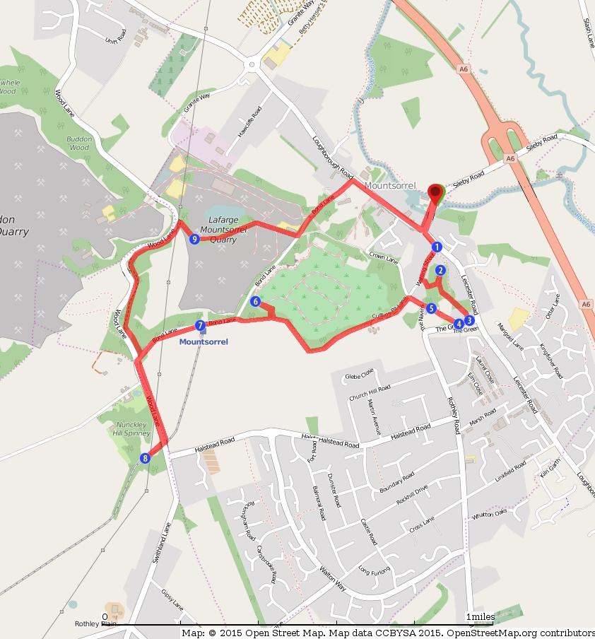
9 9 / 9
Woodland Walk If you enjoyed this walk there are two others available in the same area.
 The Woodland Walk 11-12 kilometres (7-8 miles) 4-5 hours Terrain: some easy hills Can be slippery when wet 5 stiles Unsuitable for a pushchair/wheelchair Uses OS map 197 Parking: Pulborough Station and
The Hundred Parishes
 The Hundred Parishes Walks from railway stations number 3 3 miles (5kms) circular walk from Stansted Mountfitchet Start & finish: Stansted Mountfitchet station. Ordnance Survey Explorer Map 195. Grid Reference:
U3A WALK Harby Hose. Route Summary. Route Overview. Description. Waypoints. Harby. Stuart Galloway
 U3A WALK Harby Hose Stuart Galloway Route Summary A circular walk taking in Harby, Hose and the Grantham Canal. Route Overview Category: Walking Length: 7.310 km / 4.57 mi Parking: Village Hall School
A Circular Walk from Chapel Carn Brea
 A Circular Walk from Chapel Carn Brea 4.3 Miles A Walk Visiting Five Historic Ancient Sites This circular walk offers the possibility of several alternatives, depending on the walker s available time and
U3A WTT Bagworth. Route Summary. Route Overview. Description. Waypoints. Sculpture. Stuart Galloway. A circular walk around Bagworth.
 U3A WTT Bagworth Stuart Galloway Route Summary A circular walk around Bagworth. Route Overview Category: Walking Length: 6.450 km / 4.03 mi Parking: Bagworth Heath Date Published: 27th April 2016 Difficulty:
Hay Wood, Rowington and Baddesley Clinton - Warwickshire
 Hay Wood, Rowington and Baddesley Clinton - Warwickshire Starts at Lay-by alongside Hay Wood 2 hours 30 minutes 5.5miles 8.8km Leisurely ID: 0.683 Developed by: John Clift Checked by: Andy Page www.ramblersroutes.org
Aston Rowant Discovery Trail
 The walk was developed by Aston Rowant Parish Council. The Trail is stile-free and fully way-marked. The circular route is 5.3m but with the extension to a pub and hotel 6.2m. Key Main Aston Rowant Discovery
Sponsored by. statestreet.com
 /STATESTREETISLANDWALK #ISLANDWALKJSY Sponsored by statestreet.com Important Information If you forget everything else PLEASE remember the following.» Remember to check OUT of every checkpoint» If you
BISHOPSTONE CIRCULAR WALK
 BISHOPSTONE CIRCULAR WALK 4½ miles (7¼ km) - allow 2 hours (see maps on final pages) Introduction This walk is within the North Wessex Downs Area of Outstanding Natural Beauty and starts from the small,
The. History Walk. WWII Armaments factory
 The History Walk WWII Armaments factory 4.8-6.5 kilometres (3-4 miles) 2.5-3.5 hours Terrain: easy Can be slippery when wet No stiles Unsuitable for a pushchair/wheelchair Uses OS map 197 Parking: Pulborough
FOUNDATIONS OF ARCHAEOLOGY A WALK IN VERNDITCH CHASE
 FOUNDATIONS OF ARCHAEOLOGY A WALK IN VERNDITCH CHASE 1. A Tale of two Long Barrows Long barrows were constructed as earthen or drystone mounds with flanking ditches and acted as funerary monuments during
Hindhead, Keffolds Copse and Gibbet Hill
 point your feet on a new path, Keffolds Copse and Gibbet Hill Distance: 6 km=4 miles Region: Surrey Author: Schwebefuss Refreshments: Punch Bowl Café moderate walking Date written: 14-apr-2015 Last update:
The Mendip Way. Route Directions and Maps Uphill to Wells
 The Mendip Way Route Directions and Maps Uphill to Wells Website: www.mendiphillsaonb.org.uk Email: mendip@mendiphillsaonb.org.uk Facebook & Twitter: @MendipHillsAONB Phone: 01761462338 1 Uphill to Loxton
START - UPHILL BEACH. (tidal!) The West Mendip Way is route-marked with these round blue signs
 The West Mendip Way is route-marked with these round blue signs") START - UPHILL BEACH Start Times: 10:30 11:15 12:00 Please allow sufficient time to check in with the marshals Start on the beach at the high water line (tidal!) The West Mendip Way is route-marked with
START - UPHILL BEACH Start Times: 10:30 11:15 12:00 Please allow sufficient time to check in with the marshals Start on the beach at the high water line (tidal!) The West Mendip Way is route-marked with
Leaden Boot Challenge ROUTE INSTRUCTIONS
 Leaden Boot Challenge ROUTE INSTRUCTIONS Section 1 Alstonefield to Ilam From the village hall car park turn R then L and pass through the village keeping to the R to enter Church Street. Pass the Church
U3A Markfield and Hill Hole Quarry
 U3A Markfield and Hill Hole Quarry Stuart Galloway Route Summary Circular walk around Markfield including Hill hole quarry and the Altar Stones Route Overview Category: Walking Length: 5.570 km / 3.48
Eglwyseg Mountain a landscape of prehistoric cairns and later industry
 Eglwyseg Mountain a landscape of prehistoric cairns and later industry Walk Information: Maps: OS Explorer 256 Distance: 5.3 miles / 8.5 kilometres (linear) or up to 9.6 miles / 15.5 kilometres (circular)
Leaden Boot Challenge 2016 ROUTE INSTRUCTIONS
 Leaden Boot Challenge 2016 ROUTE INSTRUCTIONS Section 1 Alstonefield to Ilam (CP2) From the village hall car park turn R then L and pass through the village keeping to the R to enter Church Street. Pass
Mersey Valley Timberland Trail
 Route Pack Page 1 Route Summary A long distance linear walk on roads and country paths linking town and countryside to parks, woodlands and other open spaces. Grade Distance Accessibility Allow Start Map
Gors Lydan barrows and medieval huts
 Walk Information: Maps: OS Explorer 214 Distance: 5.5 miles / 9 kilometres Duration: 4.5 to 5 hours Difficulty: Easy. Good paths and no steep gradients Start and finish: SO 11977545 Walk summary The walk
Excavations in a Medieval Market Town: Mountsorrel, Leicestershire,
 Excavations in a Medieval Market Town: Mountsorrel, Leicestershire, by John Lucas Mountsorrel is situated 12 kms north of Leicester and forms a linear settlement straddling the A6, Leicester to Derby road.
Pen Cerrig-calch prehistoric cairns
 Walk Information: Maps: OS Explorer OL13 Distance: 8 miles / 13 kilometres Duration: Allow at least 6 hours for the circular walk Difficulty: medium. Some narrow paths, occasionally rough underfoot Start
3.1 Bowness-on-Solway to Carlisle
 3.1 Bowness-on-Solway to Carlisle Map panel 1 Distance 15 miles (24 km) Terrain minor roads, tracks, field paths and riverside footpath, muddy in places Grade easy, with gentle gradients on undulating
Freefolk and Whitchurch
 Trail Activity Type Terrain Author Distance Ascent Location : HAMPTR0026 : Walk : Tea Shop : Towpaths and Cycle Tracks : Jean Patefield : 5.6 miles / 9 kms : 377 feet / 115 metres : SU487488 / RG28 7NN
CWMGIEDD FROM ABERCRAVE
 Abercrave to Cwmgiedd Walk Page 1 Starting from The Abercrave Inn. Grid Ref: SN 824128 From the Abercrave Inn, an 11.3km (7 miles) walk to the foothills of the Cribarth Mountain, then through forest to
Penn Common and Bramshaw Wood
 Trail Activity Type Terrain Author Distance Ascent Location : HAMPTR0025 : Walk : Pub : Towpaths and Cycle Tracks : Anne-Marie Edwards : 5.3 miles / 8.5 kms : 381 feet / 116 metres : SU253173 / SP5 2BZ
Much of the information which follows is included by kind permission of the Tynedale Council (now defunct) and is based on its brochure.
 and is based on its brochure.") The Tyne Green Trail This easy going circular walk is on level ground throughout. It follows the course of the River Tyne between Hexham Bridge and the turning point just past Watersmeet. The return is
The Tyne Green Trail This easy going circular walk is on level ground throughout. It follows the course of the River Tyne between Hexham Bridge and the turning point just past Watersmeet. The return is
The Clyde Walkway. Cambuslang Bridge to Strathclyde Country Park. Thanks to
 Thanks to The Clyde Walkway is a partnership venture based on co-operation and agreement. North Lanarkshire, South Lanarkshire and Glasgow City Councils would like to acknowledge the help and support of
Beamers Trail. Walk No.1. 6 miles. (easy with some moderate ascents and descents)
") Beamers Trail Walk No.1 6 miles (easy with some moderate ascents and descents) 1 BEAMERS TRAIL 6 miles (easy with som WALK The Warpers Trail forms part of the long distance Witton Weavers Way. This is
Beamers Trail Walk No.1 6 miles (easy with some moderate ascents and descents) 1 BEAMERS TRAIL 6 miles (easy with som WALK The Warpers Trail forms part of the long distance Witton Weavers Way. This is
Approximate distance: 4.5 miles For this walk we ve included OS grid references should you wish to use them. Start. End
 Approximate distance: 4.5 miles For this walk we ve included OS grid references should you wish to use them. 2 1 Start End 4 3 N W E S Reproduced by permission of Ordnance Survey on behalf of HMSO. Crown
Beautiful Walks from the Blue Ball Inn
 Walk No. 5 RIVER VALLEYS AND MOOR Countisbury, Watersmeet, Hillsford Bridge, Cheriton, Shilstone Hill, Rockford and Chiselcombe. 8.5 MILES APPROX. Walking time four and a half hours approx. OS 1;25,000
Pontfadog. Walk A. Walk A
 Walk A A Bird s eye view of the village 2km. (1 1 /2 miles); height gain 45m. (150ft) about 45 minutes. Six minutes walk along the main road towards Glyn Ceiriog reach a signpost to Llwynmawr. Take the
Walk 1. Cotswold Water Park. Gateway Centre to Cerney Wick, railway track to Lake 6, Gateway Centre.
 Cotswold Water ark Walk way A Swindon/ Cirencester Thomas and Severn Canal way to Cerney Wick, railway track to Lake, way. Spine Road East Hotel Time: hours (short walk km) Distance: km A level walk along
Berkhamsted and Hemel Hempstead from Iver Marina
 UK Canal Boating UK Canal Boating Escape with a canal boating holiday! Telephone : 01395 443545 Email : contact@ukcanalboating.com Booking Office : PO Box 57, Budleigh Salterton. Devon. EX9 7ZN. England.
BURGHCLERE PARISH RIGHTS OF WAY
 BURGHCLERE PARISH RIGHTS OF WAY Full descriptions compiled by Neill & Miggie Bruce All photos Miggie Bruce FP23 on Ridgemoor, looking south, with FP22 crossing by the bush FP1. From C183 Aldern Bridge
Warwick and return from Stratford upon Avon
 UK Canal Boating UK Canal Boating Escape with a canal boating holiday! Telephone : 01395 443545 Email : contact@ukcanalboating.com Booking Office : PO Box 57, Budleigh Salterton. Devon. EX9 7ZN. England.
Weatherman Walking Welshpool Approximate distance: 4 miles Start End
 Approximate distance: 4 miles For this walk we ve included OS grid references should you wish to use them. 4 3 2 1 Start End 5 6 N W E S Reproduced by permission of Ordnance Survey on behalf of HMSO. Crown
CUSERCOLI TAPPA 26 - CUSERCOLI - SANTA SOFIA CIVITELLA DI ROMAGNA KM 20,5/23, E. Emila Romagna Comune: di Civitella di Romagna Forlì-Cesena
 CUSERCOLI Emila Romagna Comune: di Civitella di Romagna Forlì-Cesena TAPPA 26 - CUSERCOLI - SANTA SOFIA KM 20,5/23,5 +680-550 E CIVITELLA DI ROMAGNA Originally the settlement of Cusercoli was enclosed
landcapes and romance Artists and poets have been inspired by the idyllic scenes of picturesque Kent villages sheltered by rolling, chalk hills.
 landcapes and romance Artists and poets have been inspired by the idyllic scenes of picturesque Kent villages sheltered by rolling, chalk hills. WALK 4 41 41 WALK 4 42 Pond Location: Distance: 5 miles
Tenerife Sur: Short Walks Under 10 km. Casa del Ancon Circular (Arona) Route Summary. Route Overview. Description
 Route Summary. Route Overview. Description") Tenerife Sur: Short Walks Under 10 km Casa del Ancon Circular (Arona) Route Summary This short circular walk from Arona is very scenic, with reminders of rural life in previous times. Route Overview Duration:
Tenerife Sur: Short Walks Under 10 km Casa del Ancon Circular (Arona) Route Summary This short circular walk from Arona is very scenic, with reminders of rural life in previous times. Route Overview Duration:
Chiselbury Camp hillfort
 Chiselbury Camp hillfort Reasons for Designation Large univallate hillforts are defined as fortified enclosures of varying shape, ranging in size between 1ha and 10ha, located on hilltops and surrounded
Orchards and oasts a taste of the Garden of England
 49 Orchards and oasts a taste of the Garden of England Open parkland, orchards, oasts and incredible panoramic views over the Weald to the South Downs make this a truly memorable walk. Linton Village 50
Self-Guided Walk Malham, Gordale and Malham Tarn
 Self-Guided Walk Malham, Gordale and Malham Tarn Combine all the major geological attractions of Malham in this walk and hopefully leave enough time to enjoy the cafes, pubs and shops of the village. Malham
HARDMOORS 55 RACE ROUTE 2018 HELMSLEY - GUISBOROUGH
 HARDMOORS 55 RACE ROUTE 2018 HELMSLEY - GUISBOROUGH HELMSLEY - CHECKPOINT 1 (WHITE HORSE) 1. Leave RACE START, continue ahead on road (Baxtons Sprunt) At crossroads turn right down Canons Garth eventualy
San Miguel to Caserio de la Hoya Circular (San Miguel)
") Tenerife Sur: Short Walks Under 10 km San Miguel to Caserio de la Hoya Circular (San Miguel) Route Summary An informative and scenic walk back in time from San Miguel to below El Roque, overlooking the
Tenerife Sur: Short Walks Under 10 km San Miguel to Caserio de la Hoya Circular (San Miguel) Route Summary An informative and scenic walk back in time from San Miguel to below El Roque, overlooking the
Slad over to Pitchcombe and back
 The walk climbs up from Slad over Wickridge Hill, descends to near Pitchcombe, then climbs back over Wickridge hill and round the back of Slad. Page 1 Start Point: SO 8718 0732 The Woolpack, Slad Length:
Aeron & Arth walks 4 walks for all the family to enjoy
 Aeron & Arth walks walks for all the family to enjoy Please take note that the maps illustrating these walks are intended as a rough guide only. You should use the most recent version of the relevant Ordnance
This path goes past an old tree nursery and sawmill. After 800m it crosses over a lane. Follow the bridleway fingerpost into the woods.
 FRENSHAM PONDS 11K CIRCULAR TRAIL 2½ HRS GU10 2DA This magnificent heathland trail starts in woodland and then brings you out onto the open heather of Frensham Common, with no roadwork! The route runs
(west) onto Charleston Boulevard. Drive 16 miles on Charleston and turn right into Red Rock
 onto Charleston Boulevard. Drive 16 miles on Charleston and turn right into Red Rock") Hike: North Peak and Ice Box Overlook up and back Trailhead: 2.5 miles up the Rocky Gap Road not mark Distance: 5 miles round trip Elevation gain: 2,694 feet Elevation Peak: 7,094 feet Time: 3 to 5 hours
Hike: North Peak and Ice Box Overlook up and back Trailhead: 2.5 miles up the Rocky Gap Road not mark Distance: 5 miles round trip Elevation gain: 2,694 feet Elevation Peak: 7,094 feet Time: 3 to 5 hours
Bowring Park Self-Guided Walking Tour
 Page 1 of 11 Bowring Park Self-Guided Walking Tour This walk starts at the Bob Whelan Field and continues into the old section of the park towards the east entrance by the duck pond. Walking instructions
Cadburys World Warwick Castle from Alvechurch
 UK Canal Boating UK Canal Boating Escape with a canal boating holiday! Telephone : 01395 443545 Email : contact@ukcanalboating.com Booking Office : PO Box 57, Budleigh Salterton. Devon. EX9 7ZN. England.
Nature Track. 900m. 789m. 2 hrs 3.1 km Circuit. Hard track 238m. Blue Mountains National Park
 Nature Track 2 hrs 3.1 km Circuit Hard track 238m Largely following the ridges around the top edge of Wentworth Falls, this track is incredibly beautiful. After taking in the great views at Edinburgh Castle
MAGAZINE-June & July 2015
 Editor: Edwin Lilly Issue 8 Email: edwin_lilly@yahoo.co.uk MAGAZINE-June & July 2015 Welcome to the June & July 2015 edition of our Magazine. This issue runs from 1st June to 31st July. Reports include:
Doncaster Circular Walk Growth of a market town
 Doncaster Circular Walk Growth of a market town Walk summary: A short, historical walk around the heritage of the market town of Doncaster. You will visit the river, canal and railway, all of which helped
Ardingly Lake, Ouse Valley, Borde Hill
 point your feet on a new path Ardingly Lake, Ouse Valley, Borde Hill Distance: 14 km=9 miles or 12½ km=8 miles Region: West Sussex Author: Hautboy Refreshments: Borde Hill Map: Explorer 135 (Ashdown Forest)
The Bridestone Rocks from Lydgate
 Print this page Back to results The Bridestone Rocks from Lydgate Ancient tracks and gritstone outcrops, with terrific views of the steepsided Cliviger Valley. Distance 5 miles (8km) Minimum time 2hrs
A428 Cambourne to Cambridge Better Bus Journeys. Landscape & Planning Appraisal Study Area. Key. Study Area. Westwick. Oakington.
 Westwick Boxworth Lower Gate Caldecote Highfields Cambridge Crow End Croft Newtown Roman Hill Harlton Source: Esri, DigitalGlobe, GeoEye, Earthstar Haslingfield Geographics, CNES/Airbus DS, USDA, USGS,
Brenig Archaeology Trail
 Walk Information: Maps: OS Explorer 264 Distance: 2.5 miles / 4 kilometres Duration: Allow 2.5 hours for the circular walk Difficulty: easy. Well-marked trail over fields. Start and finish: SH 98325741
A leisurely one mile stroll through the history of Aldershot s Manor park, considered by many as the most attractive and pleasant parts of our town.
 Figure 1 Entrance to Park from the Aldershot Green/Churchill road end A leisurely one mile stroll through the history of Aldershot s Manor park, considered by many as the most attractive and pleasant parts
Baggy Point, Croyde, North Devon
 Baggy Point, Croyde, North Devon A walk using the South West Coast Path that is likely to be suitable for people with impaired mobility or with a pushchair, wheelchair, or mobility scooter. The Coast Path
Trail Summary. Defending Hope. Three Forts Time Travellers Trail (Hope Valley)
") 6hr Jump on a bus to explore the sites of three former defensive outposts in the Hope Valley. Navio Roman Fort has level access, whilst Mam Tor and Peveril Castle require a steep climb (hence there defensive
6hr Jump on a bus to explore the sites of three former defensive outposts in the Hope Valley. Navio Roman Fort has level access, whilst Mam Tor and Peveril Castle require a steep climb (hence there defensive
Walk 1: Highfield, Lob Wood and The River Wharfe
 Walk 1: Highfield, Lob Wood and The River Wharfe Start: The Hen Pen Garden, Main Street, Addingham LS29 0NS, SE 077 498. Alternative Start: Near Bolton Bridge SE 071 525 (see page 6). Full walk: 4.5 miles
Bewl Water & the High Weald
 1 Bewl Water & the High Weald Stonegate station - Stonegate - Wallcrouch - Newbarn - Cousley Wood - Wood's Green - Wadhurst station Length: 9 ½ miles (15.3km) Underfoot: Large portions of this path are
The Copper Horse Lodge, Windsor Park George III statue and view of Windsor Castle Andy Oakes Julian P Guffogg Don Cload
 Trail Activity Area Type(s) Author Distance Ascent Location : BRKSTR0008 : Walk : Windsor and the South East : Country Escape : Andy Oakes : 5 miles / 8.1 km : 239 feet / 73 metres : SU947727 / SL4 2BT
COULTER MOTTE HISTORIC ENVIRONMENT SCOTLAND STATEMENT OF SIGNIFICANCE. Property in Care (PIC) ID: PIC092
 ID: PIC092") Property in Care (PIC) ID: PIC092 Designations: Scheduled Monument (SM90082) Taken into State care: 1932 (Guardianship) Last reviewed: 2015 HISTORIC ENVIRONMENT SCOTLAND STATEMENT OF SIGNIFICANCE COULTER
Property in Care (PIC) ID: PIC092 Designations: Scheduled Monument (SM90082) Taken into State care: 1932 (Guardianship) Last reviewed: 2015 HISTORIC ENVIRONMENT SCOTLAND STATEMENT OF SIGNIFICANCE COULTER
Archaeological Investigations Project South East Region SOUTHAMPTON 2/842 (C.80.C004) SU
 SU") SOUTHAMPTON City of Southampton 2/842 (C.80.C004) SU 4382 1336 125 BITTERNE ROAD WEST, SOUTHAMPTON Report on the Archaeological Evaluation Excavation at 125 Bitterne Road West, Southampton Russel, A. D
SOUTHAMPTON City of Southampton 2/842 (C.80.C004) SU 4382 1336 125 BITTERNE ROAD WEST, SOUTHAMPTON Report on the Archaeological Evaluation Excavation at 125 Bitterne Road West, Southampton Russel, A. D
RIVIERA LINE E X E T E R PAIGNTON
 RIVIERA LINE EXETER PAIGNTON Supported by Introduction The Riviera Line offers great scenic train journeys along the South Devon coast between Exeter and Paignton. The train is an ideal way to enjoy a
1. Medieval Newcastle showing Austinfriars and Pilgrim Street, with 55 0 North superimposed.
 55 0 North: what lies beneath. Beneath the shadow of 55 0 North lie three important places in Newcastle s long history: Austinfriars, the Holy Jesus Hospital, and Pilgrim Street. Austinfriars To the immediate
Approximate distance: 5.5 miles For this walk we ve included OS grid references should you wish to use them. Start. End
 Approximate distance: 5.5 miles For this walk we ve included OS grid references should you wish to use them. Start End 2 1 5 4 6 3 N W E 7 S Reproduced by permission of Ordnance Survey on behalf of HMSO.
Hadleigh Castle and Chalkwell Oaze
 1 Hadleigh Castle and Chalkwell Oaze Benfleet station Hadleigh Park Hadleigh Castle Leigh-on-Sea Chalkwell station A short stroll through the lush woods of Hadleigh Park high above the Thames-side marshes,
Places in Brent. Stonebridge. Grange Museum of Community History and Brent Archive
 Places in Brent Stonebridge Grange Museum of Community History and Brent Archive Stonebridge is situated in southern Brent, on the Harrow Road between Harlesden and Wembley. The 17 th and 18 th centuries
A Hull of a city. Discover how a river and an estuary have shaped Kingston-upon-Hull. Directions
 Trail A Hull of a city Discover how a river and an estuary have shaped Kingston-upon-Hull Time: 1 hr Distance: 1 ½ miles Landscape: urban Welcome to the city of Hull in the East Riding of Yorkshire. On
SAINT OSWALD S CHURCH. In the Parish of Hinstock
 SAINT OSWALD S CHURCH ( The stone Church with the warm heart ) In the Parish of Hinstock Introduction A road ran through Hinstock as long ago as Roman times when the springs which currently fill the Bearcroft
Crimdon. A walk of nature...sea, sand and countryside
 Crimdon A walk of nature......sea, sand and countryside A182 B1283 A181 Wingate B1287 Peterlee Seaham Easington B1281 Newcastle Horden Blackhall A179 Newcastle International Airport Crimdon A1086 Location...
CELEBRATE WEST GREENWICH GEOCACHING THROUGHOUT WEST GREENWICH
 CELEBRATE WEST GREENWICH GEOCACHING THROUGHOUT WEST GREENWICH The West Greenwich Land Trust (WGLT) is sponsoring Celebrate West Greenwich, an event designed to celebrate the beauty and history of scenic
Feudalism: Serfs, Knights & Castles
 Feudalism: Serfs, Knights & Castles What is Feudalism? Feudalism is a term describing the relationship between lords (nobility and church), vassals, serfs, and freemen. A lord was the lawful owner of land.
WALKS AROUND WOODHURST
 WALKS AROUND WOODHURST With Walks To Woodhurst from North St. Ives Woodhurst is situated on the verge of an elevated tract of table land four miles north of St. Ives. Its footpaths vary from leafy lanes
A Tour of the Valle del Gizio
 Walk 25 A Tour of the Valle del Gizio Walking time 5hrs 30mins (4hrs if Colle Mitra is omitted) Difficulty 2 (likely to be snowbound in winter months); 1 (if Colle Mitra is omitted) Ascent/descent 570m/570m
North Wales Miners Association Trust Ltd Wrexham South Mine Trail
 North Wales Miners Association Trust Ltd Wrexham South Mine Trail An 18 mile circular trail by car or bike, passing features relating to the local coal, lead and iron industries. Note that some of the
Control Description Sheet 1
 Control Description Sheet 1 Headings I0A Example M20 M21 M35 1 8.8km 250m Event Title Classes (optional) Course Code; Course length, Height climb Start location as if it was a control. First Control Description
Welcome to June news Nottingham Castle Transformation newsletter
 June 2016 Welcome to June news Nottingham Castle Transformation newsletter In this edition... FREE entry on Saturday 2 July Object feature - Alabasters Brewhouse Yard Dye Garden Project Leonardo exhibition
F.O.K.O.S. Friends of Kingston Open Space A GUIDE TO KINGSTON OPEN SPACE
 F.O.K.O.S. Friends of Kingston Open Space A GUIDE TO KINGSTON OPEN SPACE Friends of Kingston Open Space (FOKOS) was formed when a handful of concerned citizens joined together to learn what could be done
GRINDLEFORD GALLOP 2018
 GRINDLEFORD GALLOP 2018 Route Information The Grindleford Gallop follows a fixed 21 mile route through the lanes and paths of Derbyshire. All competitors must follow this route. An OS map of the area with
Ystwyth and Rheidol Bridleway Routes. Route 2:Llanilar Circular
 Ystwyth and Rheidol Bridleway Routes Route 2:Llanilar Circular Route overview and terrain: A long circle using connecting ridges with fine views to link the Rheidol and Ystwyth river valleys. The route
Tenerife Sur: Short Walks Under 10 km. Cabo Blanco - La Camella Circular (Arona) Route Summary. Route Overview. Description
 Route Summary. Route Overview. Description") Tenerife Sur: Short Walks Under 10 km Cabo Blanco - La Camella Circular (Arona) Route Summary An interesting town and country walk, with some marvellous views, in a well-populated residential area close
Tenerife Sur: Short Walks Under 10 km Cabo Blanco - La Camella Circular (Arona) Route Summary An interesting town and country walk, with some marvellous views, in a well-populated residential area close
RIVER AMENITY PLOT TITLE NO: ON F BRIDLEPATH F GORING ON THAMES F OXFORDSHIRE.
 RIVER AMENITY PLOT TITLE NO: ON133796 F BRIDLEPATH F GORING ON THAMES F OXFORDSHIRE www.warmingham.com RIVER AMENITY PLOT TITLE NO: ON133796 F BRIDLEPATH F GORING ON THAMES F OXFORDSHIRE Goring Railway
A Seagull Trust Union Canal Cruise East from Ratho Part 1, Bridge 15 to Bridge 13
 A Seagull Trust Union Canal Cruise East from Ratho Part 1, Bridge 15 to Bridge 13 Our cruise starts from the Seagull Trust Cruises Centre on the Union Canal at Ratho. Because our barges usually berth pointing
Approximate distance: 7.5 miles For this walk we ve included OS grid references should you wish to use them.
 Approximate distance: 7.5 miles For this walk we ve included OS grid references should you wish to use them. 6 5 7 8 4 1 2 Start End N 3 W E S Reproduced by permission of Ordnance Survey on behalf of HMSO.
Fetcham Downs and Bocketts Farm A magical teashop walk
 point your feet on a new path Fetcham Downs and Bocketts Farm A magical teashop walk Distance: 3 km=2 miles or 4 km=2½ miles Region: Surrey Author: Fusszweig Refreshments: Bocketts Farm easy walking Date
Tour of the Town. more from this section
 This document is a snapshot of content from a discontinued BBC website, originally published between 2002-2011. It has been made available for archival & research purposes only. Please see the foot of
Scheduled Monument (SM90085) Taken into State care: 1966 (Guardianship) Last reviewed: 2004 CROOKSTON CASTLE
 Taken into State care: 1966 (Guardianship) Last reviewed: 2004 CROOKSTON CASTLE") Property in Care (PIC) ID: PIC119 Designations: Scheduled Monument (SM90085) Taken into State care: 1966 (Guardianship) Last reviewed: 2004 HISTORIC ENVIRONMENT SCOTLAND STATEMENT OF SIGNIFICANCE CROOKSTON
Property in Care (PIC) ID: PIC119 Designations: Scheduled Monument (SM90085) Taken into State care: 1966 (Guardianship) Last reviewed: 2004 HISTORIC ENVIRONMENT SCOTLAND STATEMENT OF SIGNIFICANCE CROOKSTON
Aira Force & Ullswater Access Statement
 Aira Force & Ullswater Access Statement Aira Force, Watermillock, Penrith, CA11 0JS T: 017684 82067 E: ullswater@nationaltrust.org.uk Section 1: Aira Force Section 2: Ullswater Countryside Section 1: Aira
The Castor Roman Walk
 The Castor Roman Walk Welcome to the Route Plan and teachers notes for the Castor Roman Walk. The walk is approximately 3km, with an optional extension of 0.7km. We suggest that you bring with you OS Explorer
Self-guided: Trekking/biking route. The Ancient Knight path
 Self-guided: Trekking/biking route The Ancient Knight path Along the circular route you will be able to see Vaidava village, ceramics factory Vaidava Ceramics, Rubene Lutheran church, Mujāni Medieval White
Fort Ticonderoga Carillon Battlefield Walking Trail Guide
 Fort Ticonderoga Carillon Battlefield Walking Trail Guide Copyright Fort Ticonderoga. Photo Credit Carl Heilman II Length: Approximately 1¾ mile Welcome to Fort Ticonderoga s Walking Trail Blue markers
Carisbrooke. Fig. 1. Carisbrooke Castle shell-keep, c with added gatehouse and portcullis c
 Fig. 1. Carisbrooke Castle shell-keep, c. 1130-40 with added gatehouse and portcullis c. 1335. 4. Carisbrooke The castle s founder, William fitzosbern, built an enclosure castle soon after the Norman Conquest.
Cinque Terre (Short Break) The best walks between coloured villages and terraced vineyards TRIP NOTES 2019 Genius Loci Travel. All rights reserved.
 The best walks between coloured villages and terraced vineyards TRIP NOTES 2019 Genius Loci Travel. All rights reserved.") Cinque Terre (Short Break) The best walks between coloured villages and terraced vineyards TRIP NOTES 2019 Genius Loci Travel. All rights reserved. INTRODUCTION The Cinque Terre gets its name from the
Cinque Terre (Short Break) The best walks between coloured villages and terraced vineyards TRIP NOTES 2019 Genius Loci Travel. All rights reserved. INTRODUCTION The Cinque Terre gets its name from the
Just under a mile from Cawfields car park where the walk begins is Great Chesters Roman Fort. It is behind the tree, looking from the west.
 Tynedale U3A Hadrian s Wall Group Cawfields to Birdoswald Just under a mile from Cawfields car park where the walk begins is Great Chesters Roman Fort. It is behind the tree, looking from the west. Great
Reigate Hill and Gatton Park
 point your feet on a new path Reigate Hill and Gatton Park Distance: 11½ km=7 miles easy-to-moderate walking or 2 walks of 6½ km=4 miles and 5½ km=3½ miles Region: Surrey Author: Schwebefuss Refreshments:
Following the initial soil strip archaeology is sprayed up prior to planning and excavation
 Barton Quarry & Archaeology Over the past half century quarries have been increasingly highlighted as important sources of information for geologists, palaeontologists and archaeologists, both through