Who am I? National Geodetic Survey s Great Lakes Region Geodetic Advisor. John Ellingson Cell:
|
|
|
- Kelly Williamson
- 5 years ago
- Views:
Transcription


1 Who am I? National Geodetic Survey s Great Lakes Region Geodetic Advisor John Ellingson john.ellingson@noaa.gov Cell:
2 Today s Discussion 1st Topic New Datums Coming in nd Topic ---- Updated version of Geoid12B 3rd Topic ---- NCAT (Transformation Tool) 4th Topic Free NGS Training/Learning Opportunities Time slot at the end for questions.
3 1 st First Topic ---New Datums Let s start with the GEOPOTENTIAL DATUM (replacing NAVD 88) 4


4 Replacing NAVD 88.Why isn t NAVD 88 NAVD 88 suffers from bench marks that: Are often 80+ years old good enough anymore? Are almost never re-checked for movement Disappear by the thousands every year Are seldom being replaced May not exist near locations where they are needed Were all determined by leveling from a single point, allowing unwanted crosscountry error build up 5
, but in many places NAVD 88 doesn t support them very well There")
5 Why isn t NAVD 88 good enough anymore? Newer methods to determine/establish heights are available (GNSS), but in many places NAVD 88 doesn t support them very well There are areas where NAVD 88 marks are scarce.or do not exist This example is 100 miles across 6

6 Initial point of NAVD 88. FATHER POINT 7

7 Why replace NAVD 88? BIAS of Approximately ½ meter KNOWN TILT..(about a meter) from SE to NW 8 8

 GOCE (European Space Agency)")

8 GRACE (NASA and Germany) Gravity Recovery and Climate Experiment (launched 2002, decommissioned October 2017) GOCE (European Space Agency) Gravity Field and Steady-State Ocean Circulation Explorer (launched 2009, ended November 2013) 9

9 Gravity for the Redefinition of the American Vertical Datum TRANSITION TO THE FUTURE GRAV-D Goal: Create gravimetric geoid accurate to 1 cm where possible using airborne gravity data Overall Target: 2 cm accuracy orthometric heights from GNSS and a geoid model GRAV-D: Two thrusts of the project Airborne gravity survey of entire country and its holdings Long-term monitoring of geoid change Official NGS policy as of Nov 14,


10 Survey and Block Plans Data lines spaced 10 km apart Cross lines spaced km apart Flight altitude 20,000 ft. Nominal speed knots

11 GRAV-D current status 12

12 GRAV-D status in Michigan 13


13 NGS Gravity Slope Surveys to verify that GRAV-D Works GSVS 2014 GSVS 2017 GSVS
14 GRAV-D will produce the new 2022 GEOPOTENTIAL DATUM known as NAPGD2022 NGS will create a new GEOID Model in 2022 to match (use with) NAPGD2022 Older Geoid Models will NOT work with NAPGD

15 What changes can we expect to see in our orthometric heights? Some approx. delta heights in MICHIGAN
16 Let s move on to the GEOMETRIC (hz) datum (Lat/Lon/El Ht) The North American Terrestrial Reference Frame of 2022 NATRF
17 Why replace NAD 83? NAD 83 was aligned to Geodetic Reference System 1980 (GRS80), and so was the original World Geodetic System 1984 (WGS84) meaning NAD 83 IS equivalent to the original WGS 84.but NOT to the newer versions. Newer versions of WGS 84 have been developed to be consistent with updated International Terrestrial Reference Frames (ITRFXX) G730 (June 1994) G873 (January 1997) G1150 (January 2002) G1674 (February 2012) G1762 (October 2013) 0.7 m 0.2 m 0.06 m 0.01 m 0.01 m 18
18 What is the difference between ITRF 2008 and NAD 83? ITRF 08 19


19 Why a new GEOMETRIC DATUM? The big picture 20
20 How will these new datums impact my work (updated values)? Users in this region will see a GEOMETRIC (3-D) shift of about 1.6 meters (~1.2 m Lat/Lon & ~ 1.1m El. HT) Some users may take years to switch to the new datums! The NGS 10 year plan states that a transformation tool will be provided at the release of the new datums that will enable users to transform values between the older datums (NAD 83 and NAVD 88) and the new GEOMETRIC and GEOPOTENTIAL datums. 21
21 Wrap-up of 1 st Topic New Datums New GEOPOTENTIAL DATUM (vertical) named NAPGD2022 (North American-Pacific Geopotential Datum of 2022) New GEOMETRIC DATUM (hz really 3D) named NATRF2022 (North American Terrestrial Reference Frame of 2022) 22
")
22 Let s move to Topic #2: Geoid Models (Using your GNSS equipment to determine elevations) 23
23 ELLIPSOID - GEOID RELATIONSHIP H = Orthometric Height (NAVD 88) h = Ellipsoidal Height (NAD 83 (2011)) N = Geoid Height (GEOID12B) H h N Ground Surface Geoid Geoid Ellipsoid GRS80 H ~ h N N is negative in conterminous US 24
24 25 25


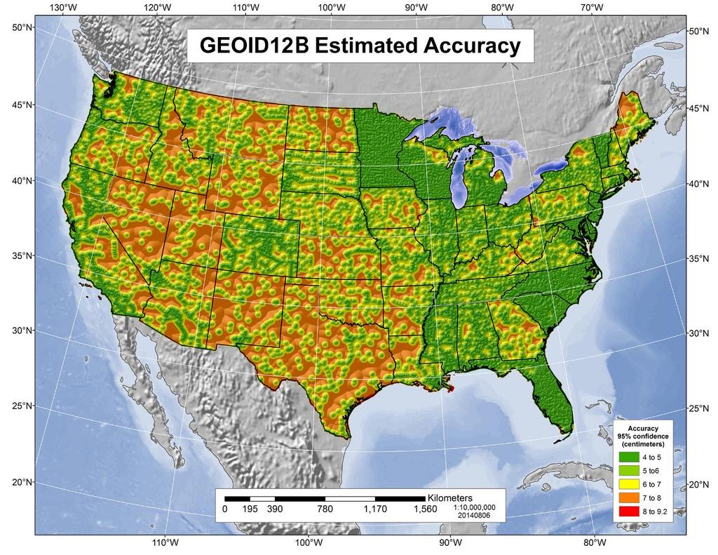
25 GEOID12A estimated accuracy map for MICHIGAN NOTE: GEOID12A & GEOID12B are equivalent in MICHIGAN 26
26 NGS is replacing Geoid12B, the current NAVD 88 geoid model NGS is working with all of our State partners to create one final improvement to the GEOID model for NAVD 88! It will be called GEOID18 Development is going on at this time.. 27
27 LAST NAVD 88 GEOID MODEL - SCHEDULE Oct Initial data pull, work is now underway Jan Deliver prototype to Advisors for review, and dispersed to users for review Mar *Surveyors Week GPSonBM campaign Aug Cut off for Data Submission by partners Oct 2018 Final database extraction for model Dec 2018 Beta product release Jan-Feb 2019 Outreach at Survey Conferences Mar 2019 Integrate new model into NGS products (OPUS, Datasheets, etc). 28
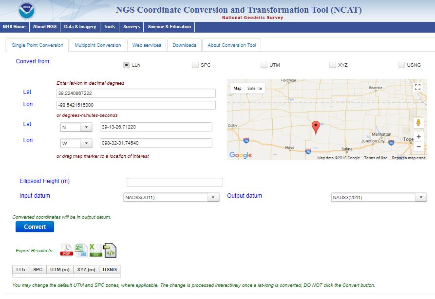
28 Now our 3rd topic: NGS Transformation Tools GEOCON 2.0..then came GEOCON 5.0 Now we have NCAT NGS COORDINATE CONVERSION AND TRANSFORMATION TOOL 29
29 30

30 It started as GEOCON
31 32

32 Remember to account for accuracy! INPUT AND OUTPUT REALIZATIONS. AVAILABLE CHOICES (1994) NOT in MI 33

33 34
34 In early February, NCAT tool was moved from Beta to Production If you experience problems, contact me. If you find a bug please inform me, or NGS.Feedback@noaa.gov 35
35 TOPIC #4 Learning Opportunities Monthly webinar series (plus archived presentations) Presentation Library YouTube Videos Corbin Training Center hands on classroom training OPUS Projects Training 36
36 37

37 NGS Monthly Webinar Series 38

38 NGS Monthly Webinar Series Register For Upcoming Topics Download Past Presentations 39

39 NGS Monthly Webinar Series Examples of past webinars that are available for download 40
40 NGS Presentations Library 41


41 YouTube Videos by NGS 42

42 NGS CORBIN TRAINING CENTER 43

43 OPUS-Projects Class - 2 days- Advisor Instructed 44
44 Odds and Ends (If time permits) NGS Industry Days coming in May 2018 Update on State Plane Coordinate Systems for New Datums OPUS-SHARE: Wait Times before you submit your data to OPUS Ultra-rapid (iguwwwwd.sp3) 6-hour latency Rapid (igrwwwwd.sp3) 13-hour latency Final or Precise (igswwwwd.sp3) 12 to 14 day latency

45 Questions. My contact information: John Ellingson NGS Great Lakes Region Geodetic Advisor Cell:
Today s topics: Elevations by GPS Datum Transformation Tool Free Learning Opportunities
 Today s topics: Elevations by GPS Datum Transformation Tool Free Learning Opportunities IMAGIN Annual Conference Traverse City, MI June 19, 2018 John Ellingson - john.ellingson@noaa.gov Great Lakes Region
The Rodman s Guide to Madison Vertical Datums
 The Rodman s Guide to Madison Vertical Datums by Dan Rodman, Wisconsin Professional Land Surveyor No. 2793 City of Madison, WI Parks Division E-mail: drodman@cityofmadison.com Tel: (608)266-6674 Version:
Data Origination, Management and WGS 84. ICAO PBN Seminar Data Origination & Management and WGS 84
 Data Origination, Management and WGS 84 1 Learning Objectives Overview Understand the implication of publishing incorrect navigational data in the State s AIP Identify why it is essential to use a common
MAY 2017 AROUND THE BEND. Survey Economics Customers & services. Mobile Scanning Bringing the goods. Black Elk Peak Definitive elevation
 MAY 2017 AROUND THE BEND Survey Economics Customers & services Black Elk Peak Definitive elevation Mobile Scanning Bringing the goods TRUE ELEVATION BLACK ELK PEAK» JERRY PENRY, PS Black Elk Peak, located
Datum Issues in the Red River of the North Basin ----
 Datum Issues in the Red River of the North Basin ---- Scoping Document May 1999 Russell E. Harkness, Hydrologist United States Geological Survey Water Resources Division 2 EXECUTIVE SUMMARY Two datum issues
Notes on the History of the National Geodetic Vertical Datum 1929 and the North American Vertical Datum 1988 in Alaska, U.S.A. 1
 1 1 2 3 4 5 6 7 8 9 10 11 12 13 14 15 16 17 18 19 20 21 22 23 24 25 26 27 Notes on the History of the National Geodetic Vertical Datum 1929 and the North American Vertical Datum 1988 in Alaska, U.S.A.
U.S. DEPARTMENT OF COMMERCE National Oceanic and Atmospheric Administration National Ocean Service Datums Page Page 1 of 5
 Datums Page Page 1 PRIMARY BENCH MARK STAMPING: 2245 A 1982 866 2245 A TIDAL MONUMENTATION: Tidal Station disk VM#: 16408 AGENCY: National Ocean Survey (NOS) PID#: DD1345 The primary bench mark is a disk
January 2018 Air Traffic Activity Summary
 January 2018 Air Traffic Activity Summary Jan-2018 Jan-2017 CY-2018 CY-2017 Passengers 528,947 505,421 4.7% 528,947 505,421 4.7% Passengers 537,332 515,787 4.2% 537,332 515,787 4.2% Passengers 1,066,279
Overview ICAO Standards and Recommended Practices for Aerodrome Mapping Data reported to AIM
 Overview ICAO Standards and Recommended Practices for Aerodrome Mapping Data reported to AIM References ICAO SARPS Annex 14 Vol. I, 7 th Edition, July 2016 ICAO SARPS Annex 15, 15 th Edition, July 2016
Challenges in Complex Procedure Design Validation
 Challenges in Complex Procedure Design Validation Frank Musmann, Aerodata AG ICAO Workshop Seminar Aug. 2016 Aerodata AG 1 Procedure Validation Any new or modified Instrument Flight Procedure is required
GFAC CHAIRMAN'S REPORT
 Annex to the agenda for the IGC plenary meeting 3-4 March 2006 To: From: Recipients of IGC Agenda Chairman IGC GNSS Flight Recorder Approval Committee (GFAC) GFAC CHAIRMAN'S REPORT This report is dated
ADVISORY CIRCULAR AC-AD-005
 GHANA CIVIL AVIATION AUTHORITY ADVISORY CIRCULAR AC-AD-005 AERODROME QUALITY DATA SYSTEM GENERAL Ghana Civil Aviation Authority (GCAA) Advisory Circulars from Aerodrome Safety and Standards (ASAS) contain
2018 WSGC WISCONSIN COLLEGIATE ROCKET DESIGN COMPETITION
 2018 WSGC WISCONSIN COLLEGIATE ROCKET DESIGN COMPETITION 11-NOV-2017 1 Welcome WSGC 2018 CRL 2 Agenda Who is competing? What is the challenge? When and where will events be taking place? When are the important
DTTAS Quarterly Aviation Statistics Snapshot Quarter Report
 Contents DTTAS Quarterly Aviation Statistics Snapshot Quarter 4 2015 Report 1.1 Dublin Airport Key Statistics... 1 1.2 Cork Airport Key Statistics... 3 1.3 Shannon Airport Key Statistics... 5 1.4 Total
DTTAS Quarterly Aviation Statistics Snapshot Quarter Report
 Contents DTTAS Quarterly Aviation Statistics Snapshot Quarter 3 2018 Report 1.1 Dublin Airport Key Statistics... 1 1.2 Cork Airport Key Statistics... 3 1.3 Shannon Airport Key Statistics... 5 1.4 Total
DTTAS Quarterly Aviation Statistics Snapshot Quarter Report
 Contents DTTAS Quarterly Aviation Statistics Snapshot Quarter 1 2018 Report 1.1 Dublin Airport Key Statistics... 1 1.2 Cork Airport Key Statistics... 3 1.3 Shannon Airport Key Statistics... 5 1.4 Total
HILLSBOROUGH COUNTY BENCHMARKS IN GOOGLE EARTH
 HILLSBOROUGH COUNTY BENCHMARKS IN GOOGLE EARTH By Thomas G. Davis 1, PhD, PE, PLS; L. Scott Brown 2, PLS; and Rollins Turner 3, PhD INTRODUCTION HCBM (http://www.metzgerwillard.us/hcbm/) is a web-based
International Transport Forum Paris February Jeffrey M. Zupan Regional Plan Association
 International Transport Forum Paris February 2013 Jeffrey M. Zupan Regional Plan Association Who Are We? Regional Plan Association Not for profit research, planning and advocacy organization in the New
STRATEGY/ACTION PLAN FOR IMPLEMENTATION OF REDUCED VERTICAL SEPARATION MINIMA IN THE AFRICA-INDIAN OCEAN REGION 22 NOVEMBER 2003
 STRATEGY/ACTION PLAN FOR IMPLEMENTATION OF REDUCED VERTICAL SEPARATION MINIMA IN THE AFRICA-INDIAN OCEAN REGION 22 NOVEMBER 2003 Prepared by the APIRG RVSM Implementation Task Force AFI STRATEGY/ACTION
National Spatial Reference System
 National Spatial Reference System NORTH AMERICAN VERTICAL DATUM OF 1988 (NAVD 88) SEMINAR January 15, 2003 Catskill, New York Edward J. McKay OUTLINE Vertical Datums Height Systems NAVD 88 Project NAVD
AERONAUTICAL SERVICES ADVISORY MEMORANDUM (ASAM) Focal Point: Gen
 Focal Point: Gen") Page 1 of 14 1 INTRODUCTION This guidance material has been prepared for use for the definition of protected surfaces in the vicinity of aerodromes. Survey information for an aerodrome is essential for
Page 1 of 14 1 INTRODUCTION This guidance material has been prepared for use for the definition of protected surfaces in the vicinity of aerodromes. Survey information for an aerodrome is essential for
CITY OF BRIDGEPORT - GEODETIC CONTROL MONUMENTATION ESTABLISHED SEPTEMBER 2008
 1 - GEODETIC CONTROL MONUMENTATION ESTABLISHED SEPTEMBER 2008 In September 2008, Baird, Hampton & Brown established positions for 8 geodetic control monuments throughout the City of Bridgeport, Texas.
#1. Why is the City doing this project?
 Community Workshop #2 January 2016 #1. Why is the City doing this project? Broadway and Lincoln are in constant change Broadway and Lincoln are in constant change Broadway and Lincoln are in constant change
UAS to GIS Utilizing a low-cost Unmanned Aerial System (UAS) for Coastal Erosion Monitoring
 for Coastal Erosion Monitoring") UAS to GIS Utilizing a low-cost Unmanned Aerial System (UAS) for Coastal Erosion Monitoring Agenda Scope of today s presentation Demonstration Objectives Wrightsville Beach Test Area Masonboro Inlet Jetties
UAS to GIS Utilizing a low-cost Unmanned Aerial System (UAS) for Coastal Erosion Monitoring Agenda Scope of today s presentation Demonstration Objectives Wrightsville Beach Test Area Masonboro Inlet Jetties
METRO OPERATIONS COMMITTEE
 Los Angeles County Metropolitan Transportation Authority Item 1 CHIEF OPERATIONS OFFICER S S REPORT METRO OPERATIONS COMMITTEE Lonnie Mitchell Chief Operations Officer May 19, 20 1 Employee Recognition
Massachusetts Health Care Training Forum. April 2014
 Massachusetts Health Care Training Forum April 2014 Agenda 1. Welcome 2. Revalidation 3. ICD-10 Implementation Project: Update 4. Questions and Answers 1. MassHealth Resources REMINDER: KEEP YOUR PROVIDER
POST-IMPLEMENTATION COMMUNITY IMPACT REVIEW
 POST-IMPLEMENTATION COMMUNITY IMPACT REVIEW RNAV STAR updates and RNP AR approaches at Edmonton International Airport NAV CANADA 77 Metcalfe Street Ottawa, Ontario K1P 5L6 January 2018 The information
T H E VILLAGE OF P h i l m o n t, N Y
 T H E VILLAGE OF P h i l m o n t, N Y Summit Reservoir Area Plan November 17, 2014 Executive Steering Committee Meeting 2 Agenda 1:00 1. Welcome 2. Housekeeping & updates i. Committee contact list review
Warming planet, melting glaciers
 Warming planet, melting glaciers Arun B Shrestha abshrestha@icimod.org International Centre for Integrated Mountain Development Kathmandu, Nepal Asia-Pacific Youth forum on Climate Actions and Mountain
Spatio-temporal Data Analysis and Visualization in Enterprise Level Automated Application
 Spatio-temporal Data Analysis and Visualization in Enterprise Level Automated Application Sept 29 - Oct 1, 2015 Kualal Lumpur Shyam Parhi Washington DC What is driving Airports GIS? Reduce costs to Airports,
POST-IMPLEMENTATION COMMUNITY IMPACT REVIEW
 POST-IMPLEMENTATION COMMUNITY IMPACT REVIEW RNAV STAR updates and RNP AR approaches at Winnipeg James Armstrong Richardson International Airport NAV CANADA 77 Metcalfe Street Ottawa, Ontario K1P 5L6 November
FLIGHT OPERATIONS INTRODUCTION ICAO Air Navigation Commission
 FLIGHT OPERATIONS INTRODUCTION ICAO Air Navigation Commission Access is a huge problem 2 out of 3 people in the world are not connected to the internet current solutions fail to effectively serve the needs
Annual Weather Book RECORDED BY NW RESEARCH & OUTREACH CTR. By: Michael Leiseth
 Annual Weather Book RECORDED BY NW RESEARCH & OUTREACH CTR. By: Michael Leiseth Table I II 1 2 3 4 5 6 7 8 9, 10 11, 12 13, 14 15, 16 17 18 An average year in Crookston, MN. Seasonal extremes in Crookston,
Federal GIS Conference February 10 11, 2014 Washington DC. ArcGIS for Aviation. David Wickliffe
 Federal GIS Conference 2014 February 10 11, 2014 Washington DC ArcGIS for Aviation David Wickliffe What is ArcGIS for Aviation? Part of a complete system for managing data, products, workflows, and quality
Air China Limited Annual Results. March Under IFRS
 Air China Limited 21 Annual Results Under IFRS March 211 Agenda Part 1 Highlights Part 2 Business Overview Part 3 Financial Overview Part 4 Outlook 2 Part 1 Highlights Steady Economic Growth; Asia Pacific
Hydrology Input for West Souris River IWMP
 Hydrology Input for West Souris River IWMP Prepared by: Mark Lee Manitoba Water Stewardship 1 1 1 Overall view of: drainage area watershed characteristics gauging stations meteorological stations Runoff
California Real-Time Network (CRTN) September 28 th, 2012 Ontario, CA. October 5 th, 2012 Sacramento, CA. Presenter: Art Andrew CSRC Chairperson
 September 28 th, 2012 Ontario, CA. October 5 th, 2012 Sacramento, CA. Presenter: Art Andrew CSRC Chairperson") California Real-Time Network (CRTN) September 28 th, 2012 Ontario, CA October 5 th, 2012 Sacramento, CA Presenter: Art Andrew CSRC Chairperson CRTN Workshop Agenda 8:30-9:15 History of CSRC and CRTN Art
California Real-Time Network (CRTN) September 28 th, 2012 Ontario, CA October 5 th, 2012 Sacramento, CA Presenter: Art Andrew CSRC Chairperson CRTN Workshop Agenda 8:30-9:15 History of CSRC and CRTN Art
POST-IMPLEMENTATION COMMUNITY IMPACT REVIEW
 POST-IMPLEMENTATION COMMUNITY IMPACT REVIEW RNAV STAR updates and RNP AR approaches at Halifax Stanfield International Airport NAV CANADA 77 Metcalfe Street Ottawa, Ontario K1P 5L6 November 2017 The information
MEDIA KIT 2018 MEDIA KIT 2018 DELIVERING AN AUDIENCE OF ENGAGED AND INFLUENTIAL FASHION BUSINESS PROFESSIONALS.
 MEDIA KIT 2018 DELIVERING AN AUDIENCE OF ENGAGED AND INFLUENTIAL FASHION BUSINESS PROFESSIONALS. Ragtrader Ragtrader is Australia s oldest and most reputable fashion business media brand. Ragtrader s worth
Flight Operations in Low Visibility Conditions
 Flight Operations in Low Visibility Conditions Eduardo Chacin ICAO NACC Regional Office, Flight Safety Meeting to enhance State Coordination between MET, AIM, and ATM fields Mexico City, Mexico, 26-28
Exhibit 4 Page 1 of 9
 % Page 1 of 9 Prior Contract No. X1054111B1 Awarded 2/12/13 (Schindler Elevator Corp.) Union Rates for Local 71 NEBA 2018 Agreement with IUEC Miami-Dade County Contract No. E9946-0/18 Awarded 12/18/17
ONE-ENGINE INOPERATIVE FLIGHT
 ONE-ENGINE INOPERATIVE FLIGHT 1. Introduction When an engine fails in flight in a turbojet, there are many things the pilots need to be aware of to fly the airplane safely and get it on the ground. This
Technical Report. Aircraft Overflight and Noise Analysis. Brisbane, California. December Prepared by:
 Aircraft Noise Abatement Office Technical Report Aircraft Overflight and Noise Analysis Brisbane, California Prepared by: P.O. Box 8097 San Francisco, California 94128 (650) 821-5100 Introduction In response
NOISE AND FLIGHT PATH MONITORING SYSTEM BRISBANE QUARTERLY REPORT OCTOBER - DECEMBER 2013
 NOISE AND FLIGHT PATH MONITORING SYSTEM BRISBANE QUARTERLY REPORT OCTOBER - DECEMBER 213 Date Version Comments Page 2 Foreword Airservices Australia has established a Noise and Flight Path Monitoring System
IHO Capacity Building in the South West Pacific Region NZ Perspective. Adam Greenland National Hydrographer Land Information New Zealand
 IHO Capacity Building in the South West Pacific Region NZ Perspective Adam Greenland National Hydrographer Land Information New Zealand Overview Introduction to Capacity Building IHO Strategy, Plan and
Sound Transit Operations January 2014 Service Performance Report. Ridership
 Ridership Total Boardings by Mode Mode Jan-13 Jan-14 % YTD-13 YTD-14 % ST Express 1,343,290 1,426,928 6.2% 1,343,290 1,426,928 6.2% Sounder 245,135 256,775 4.7% 245,135 256,775 4.7% Tacoma Link 86,229
NOISE AND FLIGHT PATH MONITORING SYSTEM BRISBANE QUARTERLY REPORT JULY - SEPTEMBER 2011
 NOISE AND FLIGHT PATH MONITORING SYSTEM BRISBANE QUARTERLY REPORT JULY - SEPTEMBER 211 Date Version Comments Page 2 Foreword Airservices Australia has established a Noise and Flight Path Monitoring System
Visit Wales Research Update
 Visit Wales Research Update 19 January 21 This update summarises tourism performance by drawing upon Visit Wales own research and information from other relevant sources. It is based upon information available
Post tsunami Recovery of Port and Harbor areas in Japan from the 2011 Great East Japan Earthquake Tsunami
 Date : 18 Nov., 2015 Venue : Furama Ballroom 1 SESSION 1 : A Decade of Partnerships in Sustainable Development of the Seas of East Asia: Synergies and Achievements WORKSHOP 1.1 : Managing Risks in Climate
SUPPLEMENT A33 TO THE AIRPLANE FLIGHT MANUAL DA 40 NG. Integrated Avionics System Garmin G1000,
 DA 40 NG AFM Garmin G1000, P-RNAV Operation SUPPLEMENT A33 TO THE AIRPLANE FLIGHT MANUAL DA 40 NG Integrated Avionics System Garmin G1000, Doc. No. : 6.01.15-E Date of Issue : Design Change Advisory :
Policy and Procedures Documents for the State Plane Coordinate System of 2022
 This document is scheduled to be published in the Federal Register on 04/18/2018 and available online at https://federalregister.gov/d/2018-08141, and on FDsys.gov BILLING CODE: 3510-JE DEPARTMENT OF COMMERCE
Building A Vibrant Air Cargo Hub at Singapore Changi Airport
 Building A Vibrant Air Cargo Hub at Singapore Changi Airport 30 October 2012 Presented By: James Fong Assistant Vice President Cargo and Logistics Development Contents Quick intro & Brief History of Changi
Global Airline Trends and Impacts International Aviation Issues Seminar
 Global Airline Trends and Impacts International Aviation Issues Seminar December 2017, Washington D.C. Oliver Lamb Managing Director 1 Around the world in 45 minutes Financial Performance Canada Mexico
Measuring Ground Delay Program Effectiveness Using the Rate Control Index. March 29, 2000
 Measuring Ground Delay Program Effectiveness Using the Rate Control Index Robert L. Hoffman Metron Scientific Consultants 11911 Freedom Drive Reston VA 20190 hoff@metsci.com 703-787-8700 Michael O. Ball
Sound Transit Operations March 2018 Service Performance Report. Ridership
 March 218 Service Performance Report Ridership Total Boardings by Mode Mar-17 Mar-18 % YTD-17 YTD-18 % ST Express 1,622,116 1,47,79-4.6% 4,499,798 4,428,14-1.6% Sounder 393,33 39,6.% 1,74,96 1,163,76 8.3%
Pacific Project. CPWG/8 - WP/6 Appendix A
 Pacific Project CPWG/8 - WP/6 Pacific Project Objective This project aims to substantially improve operational efficiency and environmental outcomes on the major air traffic flow between North America
AUGUST 2017 GNSS REVIEW. Survey Economics Chances of success. Mobile Mapping Airport scanning. Stag s Leap Winery Pre-construction plan
 AUGUST 2017 GNSS REVIEW Survey Economics Chances of success Stag s Leap Winery Pre-construction plan Mobile Mapping Airport scanning RISING PERFORMANCE» ERIK DAHLBERG Civil aviation is an outlier. It s
DSNA NAVIGATION STRATEGY
 DSNA NAVIGATION STRATEGY PBN & GNSS Ministère de l'écologie, du Développement durable, et de l Énergie PBN IMPLEMENTATION DRIVERS IN FRANCE ICAO directions towards PBN Improve Safety and Airspace Capacity,
Performance Metrics for Oceanic Air Traffic Management. Moving Metrics Conference Pacific Grove, California January 29, 2004 Oceanic Metrics Team
 Performance Metrics for Oceanic Air Traffic Management Moving Metrics Conference Pacific Grove, California January 29, 2004 Oceanic Metrics Team Agenda Metrics Team Michele Merkle, FAA AUA-600 Lynne Hamrick,
RISING PERFORMANCE. Civil aviation is an outlier. It s BY ERIK DAHLBERG
 RISING PERFORMANCE Compact mobile mapping systems can be installed on small passenger cars. Civil aviation is an outlier. It s among the few industries where tight government regulations are widely accepted
$6.60 NEW SOUTH WALES. Both METRIC and Feet and Inches TIMES: am/pm Sunrise/Sunset Moon Phases Moon Rise/Set DIARY NOTES.
 $6.60 (incl. GST) 2018 2014 November 28, 2013 November 23, 2017 TO to January 2, 7, 2019 2015 Both METRIC and Feet and Inches TIMES: am/pm Sunrise/Sunset Moon Phases Moon Rise/Set DIARY NOTES NEW SOUTH
RNP OPERATIONS. We will now explain the key concepts that should not be mixed up and that are commonly not precisely understood.
 RNP OPERATIONS 1. Introduction Planes were made as a means of transport. To successfully fly from a location A to a location B, pilots were first and foremost navigators. Originally relying on visual landmarks
NEW SOUTH WALES. Both METRIC and Feet and Inches TIMES: am/pm Sunrise/Sunset Moon Phases Moon Rise/Set DIARY NOTES.
 2016 2014 November 28, 2013 November 26, 2015 TO to January 4, 7, 2017 2015 Both METRIC and Feet and Inches TIMES: am/pm Sunrise/Sunset Moon Phases Moon Rise/Set DIARY NOTES NEW SOUTH WALES Public Works
PBN Airspace Design Workshop. Area Navigation. Asia and Pacific Regional Sub-Office Beijing, China. 5 May 2016 Page 1 APAC RSO BEIJING
 PBN Airspace Design Workshop Area Navigation Asia and Pacific Regional Sub-Office Beijing, China 5 May 2016 Page 1 APAC RSO BEIJING Learning Objectives By the end of this presentation, you will be: Aware
International Osoyoos Lake Board of Control Annual Report to the International Joint Commission
 International Osoyoos Lake Board of Control 2013 Annual Report to the International Joint Commission TABLE OF CONTENTS ACTIVITIES OF THE BOARD... 1 HYDROLOGIC CONDITIONS IN 2013... 2 Drought Criteria...
International Civil Aviation Organization CHINA RMA REPORT. (Presented by the China RMA) SUMMARY
 SUMMARY") International Civil Aviation Organization RASMAG/17 WP15 28-31/8/2012 The 17 th Meeting of the Regional Airspace Safety Monitoring Advisory Group (RASMAG/17) Bangkok, Thailand, 28 31 August 2012 Agenda
International Civil Aviation Organization RASMAG/17 WP15 28-31/8/2012 The 17 th Meeting of the Regional Airspace Safety Monitoring Advisory Group (RASMAG/17) Bangkok, Thailand, 28 31 August 2012 Agenda
USING ENGINEERING SURVEY TECHNIQUES FOR THE TONKOLILI RAILWAYS PROJECT. Prof. Maricel PALAMARIU, Ph.D. Eng. Lect. Mircea PUȘCAȘ, Eng.
 USING ENGINEERING SURVEY TECHNIQUES FOR THE TONKOLILI RAILWAYS PROJECT Prof. Maricel PALAMARIU, Ph.D. Eng. Lect. Mircea PUȘCAȘ, Eng. Marrakech, Morocco, 18-22 May 2011 Contents 1. Introduction 2. Phase
Sound Transit Operations January 2017 Service Performance Report. Ridership. Total Boardings by Mode
 January 217 Service Performance Report Ridership ST Express Sounder Tacoma Link Link Paratransit Jan-16 Jan-17 % 1,433,7 1,3,33 4.9% 331,27 7,121 98,411 3,633 Total Boardings by Mode 363,6 74,823 1,76,914
Surgical Services and Observation Unit Project Given by Highland Hospital to the Highland Park Community.
 Overview Surgical Services and Observation Unit Given by Highland Hospital to the Highland Park. 1 Review of Progress to Date July Sector 6 meeting Overview of Highland facility needs and building addition
Sound Transit Operations January 2018 Service Performance Report. Ridership
 January 218 Service Performance Report Ridership Total Boardings by Mode Jan-17 Jan-18 % YTD-17 YTD-18 % ST Express 1,3,33 1,7,91.3% 1,3,33 1,7,91.3% Sounder 367,33 416,8 13.3% 367,33 416,8 13.3% Tacoma
AIRSERVICES AUSTRALI A
 AIRSERVICES AUSTRALI A NOISE AND FLIGHT PATH MONITORING SYSTEM BRISBANE QUARTERLY REPORT JANUARY - MARCH 211 Page 2 Foreword Airservices Australia has established a Noise and Flight Path Monitoring System
AERONAUTICAL SURVEYS & INSTRUMENT FLIGHT PROCEDURES
 AERONAUTICAL SURVEYS & INSTRUMENT FLIGHT PROCEDURES Current as of November 2012 ALASKA AVIATION SYSTEM PLAN UPDATE Prepared for: State of Alaska Department of Transportation & Public Facilities Division
Analysis of en-route vertical flight efficiency
 Analysis of en-route vertical flight efficiency Technical report on the analysis of en-route vertical flight efficiency Edition Number: 00-04 Edition Date: 19/01/2017 Status: Submitted for consultation
STATE -OF-ART OF GEODESY IN THE REPUBLIC OF MACEDONIA
 STATE -OF-ART OF GEODESY IN THE REPUBLIC OF MACEDONIA Prof. Zlatko Srbinoski PhD Faculty of Civil Engineering Chair for high geodesy VIENNA, JULY 2008 REPUBLIC OF MACEDONIA Center of Balkan Peninsula a2
Commercial Accommodation Monitor: December 2017
 Commercial Accommodation Monitor: December 2017 Queenstown i Reproduction of material Material in this report may be reproduced and published, provided that it does not purport to be published under government
EQUIP General Aviation Equipage Work Group Briefing. Date: November 28, 2017
 EQUIP 2020 General Aviation Equipage Work Group Briefing Presented by: Co-Chairs Bobby Nichols, FAA & Jens Hennig, GAMA with Hank Cabler, Jim Marks & Anna Allen Date: November 28, 2017 Equip 2020 Efforts
Sound Transit Operations February 2018 Service Performance Report. Ridership
 February 218 Service Performance Report Ridership Total Boardings by Mode Feb-17 Feb-18 % YTD-17 YTD-18 % ST Express 1,373,96 1,372,88 -.1% 2,877,294 2,88,719.1% Sounder 314,96 32,187 11.9% 681,923 768,69
Poland Ground Based Augmentation System (GBAS) Seminar AGENDA. GBAS Overview (Honeywell: Pat Reines)
 Seminar AGENDA. GBAS Overview (Honeywell: Pat Reines)") Poland Ground Based Augmentation System (GBAS) Seminar AGENDA 0900-0915 0915-0930 0930-1030 1030-1045 1045-1115 1115-1145 1145-1245 1245-1345 1345-1445 1445-1515 Welcome (PANSA) Introductions (All) GBAS
Poland Ground Based Augmentation System (GBAS) Seminar AGENDA 0900-0915 0915-0930 0930-1030 1030-1045 1045-1115 1115-1145 1145-1245 1245-1345 1345-1445 1445-1515 Welcome (PANSA) Introductions (All) GBAS
Commercial Accommodation Monitor: October 2017
 Commercial Accommodation Monitor: October 2017 Hawke s Bay i Reproduction of material Material in this report may be reproduced and published, provided that it does not purport to be published under government
NOISE AND FLIGHT PATH MONITORING SYSTEM MELBOURNE QUARTERLY REPORT JULY - SEPTEMBER 2011
 NOISE AND FLIGHT PATH MONITORING SYSTEM MELBOURNE QUARTERLY REPORT JULY - SEPTEMBER 211 Date Version Comments Page 2 Foreword Airservices Australia has established a Noise and Flight Path Monitoring System
Muography on Puy de Dôme. C Cârloganu LPC Clermont Ferrand IN2P3/CNRS
 Muography on Puy de Dôme C Cârloganu LPC Clermont Ferrand IN2P/CNRS Proof of principle of muography on km sized volcanoes Puy de Dôme muography reference site Institute of Nuclear Physics of Lyon Proof
NOISE AND FLIGHT PATH MONITORING SYSTEM MELBOURNE QUARTERLY REPORT OCTOBER - DECEMBER 2012
 NOISE AND FLIGHT PATH MONITORING SYSTEM MELBOURNE QUARTERLY REPORT OCTOBER - DECEMBER 212 Date Version Comments Page 2 Foreword Airservices Australia has established a Noise and Flight Path Monitoring
Produced by: Destination Research Sergi Jarques, Director
 Produced by: Destination Research Sergi Jarques, Director Economic Impact of Tourism Oxfordshire - 2015 Economic Impact of Tourism Headline Figures Oxfordshire - 2015 Total number of trips (day & staying)
PRIMARY EDUCATION PACK PROBLEM SOLVING
 PRIMARY EDUCATION PACK www.titanclydebank.com Titan Problem Solving 1 The above picture represents a section of the Titan Crane. In constructing this section the materials listed below were used: 2 beams
Commercial Accommodation Monitor: April 2017
 Commercial Accommodation Monitor: April 2017 Hawke s Bay i Reproduction of material Material in this report may be reproduced and published, provided that it does not purport to be published under government
International Visitation to the Northern Territory. Year ending December 2017
 International Visitation to the Northern Territory Year ending December 2017 The following is a summary of information relevant to the Northern Territory (NT) tourism industry including visitation results
Developing an Aircraft Weight Database for AEDT
 17-02-01 Recommended Allocation: $250,000 ACRP Staff Comments This problem statement was also submitted last year. TRB AV030 supported the research; however, it was not recommended by the review panel,
NOISE AND FLIGHT PATH MONITORING SYSTEM MELBOURNE QUARTERLY REPORT JULY - SEPTEMBER 2013
 NOISE AND FLIGHT PATH MONITORING SYSTEM MELBOURNE QUARTERLY REPORT JULY - SEPTEMBER 213 Date Version Comments Page 2 Foreword Airservices Australia has established a Noise and Flight Path Monitoring System
Product Description. SmartRunway and SmartLanding. functions of the. Enhanced Ground Proximity Warning System
 Product Description SmartRunway and SmartLanding functions of the Enhanced Ground Proximity Warning System Table of Contents 1. PURPOSE AND APPLICABILITY -------------------------------------------------------------------------------
A Pilot s perspective
 The Challenges of Modern Approaches, from NPA/PA to 2D/3D operations airborne perspective A Pilot s perspective Stefan Fiedler IFALPA, VC German Cockpit IFALPA Position on PBN (December 2014) IFALPA welcomes
GNSS AVIATION APPLICATIONS AND PROGRAMMES IN MADAGASCAR
 UNTED NATIONS INTERNATIONAL MEETING ON THE APPLICATIONS OF GLOBAL NAVIGATION SATELLITE SYSTEMS Vienna, Austria 12 16 December 2011 GNSS AVIATION APPLICATIONS AND PROGRAMMES IN MADAGASCAR Presented by:
AIS-AIMSG/12-SN/3 - Appendix A. New Annex 15. (Consolidated draft, 14 OCT 2015)
") AIS-AIMSG/12-SN/3 - Appendix A New Annex 15 (Consolidated draft, 14 OCT 2015) Contents CHAPTER 1. GENERAL 4 1.1 Definitions 4 1.2 Common reference systems for air navigation 10 1.2.1 Horizontal reference
AIS-AIMSG/12-SN/3 - Appendix A New Annex 15 (Consolidated draft, 14 OCT 2015) Contents CHAPTER 1. GENERAL 4 1.1 Definitions 4 1.2 Common reference systems for air navigation 10 1.2.1 Horizontal reference
Less Money. Fewer Staff
 SMS, the Small Airport s Perspective! Less Money Fewer Staff Fewer Customers The Panel of Experts! Dr. Jose Ruiz, Southern Illinois Airport Dr. Seth Young, Ohio State University Airport Bruce MacLachlan,
I T N E T R E N R A N T A I T ON O AL A L A R A R R I R VA V L A S L S A N A D N D D E D PA
 INTERNATIONAL ARRIVALS AND DEPARTURES July 2015 Government of Tonga SD18M-36 Statistical Bulletin Month of Change from Change from July 2015 Number previous month previous year All Arrivals 8,252-28.0
MONTHLY OPERATIONS REPORT SEPTEMBER 2015
 MONTHLY OPERATIONS REPORT SEPTEMBER 215 Table of Contents SEPTEMBER 215 Section Page September Highlights... 3 Strategic Goals Progress Update... 4 Ridership... 6 Revenue... 9 Expenses... 1 System Summary...
State Unclaimed Property Administrators Survey September 2018
 State Unclaimed Property Administrators Survey September 2018 Has there been a change in the website URL where the due diligence and reporting information is provided? If yes, please Montana: https://mtrevenue.gov/property/unclaimed-property-holders/
AIR/GROUND SIMULATION OF TRAJECTORY-ORIENTED OPERATIONS WITH LIMITED DELEGATION
 AIR/GROUND SIMULATION OF TRAJECTORY-ORIENTED OPERATIONS WITH LIMITED DELEGATION Thomas Prevot Todd Callantine, Jeff Homola, Paul Lee, Joey Mercer San Jose State University NASA Ames Research Center, Moffett
Cruise worldwide 2012
 Cruise worldwide 2012 20,12 M passengers Nationalities 12,16M North America 5,64M Europe 2,32 Rest of the world 2% of global tourism Portugal Cruise passengers 783 750 945 738 1 066 963 1 219 614 1 314
MARKET NEWSLETTER No 57 January 2012
 OVERVIEW OF INTRA-EUROPEAN UNION TRADING BETWEEN 2007/08 AND 2010/11 The data on intra-eu trade reported in this month s newsletter have been taken from the EUROSTAT database. However, it is important
The Geography of Climate
 The Geography of Climate Objective for Today: Today we will examine ways that latitude and landforms influence climate The focus of our study will be the South American Continent in the Formal Region known