National Spatial Reference System
|
|
|
- Hugo Austen Hoover
- 5 years ago
- Views:
Transcription
1 National Spatial Reference System NORTH AMERICAN VERTICAL DATUM OF 1988 (NAVD 88) SEMINAR January 15, 2003 Catskill, New York Edward J. McKay
2 OUTLINE Vertical Datums Height Systems NAVD 88 Project NAVD 88 Implementation FEMA & NAVD 88 NAVD 88 Conversion Techniques NATIONAL OCEAN SERVICE 2
3 NATIONAL SPATIAL REFERENCE SYSTEM The National Spatial Reference System (NSRS) is the name given to all geodetic control contained in the National Geodetic Survey (NGS) Data Base. This includes: A, B, First, Second and Third-Order horizontal and vertical control, Geoid models such as GEOID 99, precise GPS orbits and Continuously Operating Reference Stations (CORS), observed by NGS as well as data submitted by other Federal, State, and local agencies, academic institutions and the private sector NATIONAL OCEAN SERVICE 3
4 VERTICAL DATUMS SEA LEVEL DATUM OF 1929 NATIONAL GEODETIC VERTICAL DATUM OF 1929 (As of July 2, 1973) NORTH AMERICAN VERTICAL DATUM OF 1988 (As of June 24, 1993) NATIONAL OCEAN SERVICE 4
5 COMPARISON OF VERTICAL DATUM ELEMENTS NGVD 29 NAVD 88 DATUM DEFINITION 26 TIDE GAUGES FATHER S POINT/RIMOUSKI IN THE U.S. & CANADA QUEBEC, CANADA BENCH MARKS 100, ,000 LEVELING (Km) 102,724 1,001,500 GEOID FITTING Distorted to Fit MSL Gauges Best Continental Model 5
6 NORTH AMERICAN VERTICAL DATUM 88 WHAT IS A VERTICAL CONTROL NETWORK? An Interconnected System of Bench Marks Each Bench Mark Is Assigned A height Referenced To A Common Surface 6
7 NORTH AMERICA VERTICAL WHY DO WE NEED A VERTICAL CONTROL NETWORK? Reduces The Amount Of Future Leveling Required Enables Surveyors To Check Their New Leveling Provides Backups For Destroyed Or Disturbed Bench Marks Assists In Monitoring Changes In Local Areas Provides A Common Framework 7
8 HEIGHT SYSTEMS FIVE STEPS TO CREATING A VERTICAL CONTROL NETWORK Recon level line and set new bench marks Observe height differences between bench marks Correct observations for known systematic effects Minimize discrepancies in the results obtained by leveling along different routes between the same two points Define the surface datum to which heights may be referred 8
9 9
10 Leveled Height vs. Orthometric Height Equipotential Surfaces h = local leveled differences H = relative orthometric heights B Topography A h AB = h BC C H A H AC h AB + h BC H C Reference Surface (Geoid) Observed difference in orthometric height, H, depends on the leveling route. 10
11 Leveling - Derived Orthometric Heights Level Surfaces P Earth s Surface Plumb Line Mean Sea Level Geoid P O Ocean Level Surface = Equipotential Surface H (Orthometric Height) = Distance along Plumb line (P O to P) 11
12 Heights Based on Geopotential Number NormalHeight (NGVD29) H* = C / γ γ = Average normal gravity along plumb line Dynamic Height (IGLD55,85) H dyn = C / γ 45 γ 45 = Normal gravity at 45 latitude Orthometric Height g = Average gravity along the plumb line H = C / g HelmertHeight (NAVD 88) H = C / (g H) g = Surface gravity measurement (mgals) 12
13 The Geoid The geoid is the equipotential surface of the earth s attraction and rotation which, on the average, coincides with mean sea level in the open ocean. 13
14 Execution of Surveys; Sources of Error Errors may be characterized as random, systematic, or blunders Random error represents the effect of unpredictable variations in the instruments, the environment, and the observing procedures employed Systematic error represents the effect of consistent inaccuracies in the instruments or in the observing procedures Blunders or mistakes are typically caused by carelessness and are detected by systematic checking of all work through observational procedures and methodology designed to allow their detection and elimination 14
15 Geodetic Control Network of Monumented Points Precisely Measured in Accordance with Standard Procedures Meet Accuracy Specifications Adjusted to Tie Together Documented for Multiple Use 15
16 HEIGHT SYSTEMS GEOPOTENTIAL NUMBERS Although geopotential numbers are useful for the adjustment of vertical networks, for many purposes true orthometric heights above a physically defined reference surface are still necessary A geopotential number can be converted to a true orthometric height by dividing the geopotential number by the mean value of gravity along the plumb line between the point and the reference surface H = C/gm Since the mean value of gravity cannot be directly measured (because the reference surface lies within the Earth beneath the point), a model must be used to derive the value as a point, and other variables 16
17 HEIGHT SYSTEMS GEOPOTENTIAL NUMBERS The geopotential number of a point is a measure of the difference in potential from the reference surface to the equipotential surface passing through the point The geopotential number is numerically equivalent to the work required to raise a mass of 1 Kg against gravity (g) through the orthometric height (H) to the point: H Geopotential number (C) = g dh 0 The difference in height (dh) measured during each setup of leveling can be converted to a difference in potential by multiplying dh by the mean value of gravity (gm) for the setup Geopotential difference = gm*dh 17
18 HEIGHT SYSTEMS GEOPOTENTIAL NUMBERS The geopotential number C is measured in geopotential units (gpu) 1 gpu = 1 Kgal meter = 1000 gal meter g = 0.98 Kgal c 0.98 H (Reference: Physical Geodesy by Heiskanen and Moritz) 18
19 HEIGHT SYSTEMS SEA LEVEL HEIGHTS Heights measured above local mean sea level The National Tidal Datum epoch is a particular 19 - year series over which the phases (such as mean lower low water) are determined. Encompasses all significant tidal periods Including the year period for the regression of the Moon s nodes Averages out practically all of the meteorological, hydrological, and oceanographic variability Leveling is used to determine the relationship between bench marks and tidal gages 19
20 HEIGHT SYSTEMS DATUMS Any surface defined as the reference surface from which heights are measured, can be called a datum International Great Lakes Datum (IGLD)1955 Defined by one height (Father Point) Water - level transfers used to connect leveling across the Great Lakes Dynamic heights o H - C/G ; Gε gals (Normal gravity at 45 degrees latitude as defined in 1955) 20
21 HEIGHT SYSTEMS DATUMS National Geodetic Vertical Datum of 1929 (NGVD 29) Defined by heights of 26 tidal stations in the U.S. and Canada Tide gages were connected to the vertical network by leveling from tide gage staffs to bench marks Water - Level transfers used to connect leveling across the Great Lakes Normal orthometric heights H - C/Ga; Ga - Normal gravity based on formula 21
22 HEIGHT SYSTEMS DATUMS North American Vertical Datum of 1988 (NAVD 88) Defined by one height (Father Point/Rimouski) Water-level transfers used to connect leveling across the Great Lakes Geopotential Numbers Helmert orthometric heights Hhel - C/Ga; Ga = Mean value of gravity along the plumb line between the geoid and surface, estimated using Helmert s reduction, I.e., g xHo. g = gravity at the surface in gals Ho = approximate height in kilometers 22
23 HEIGHT SYSTEMS DATUMS INTERNATIONAL Great Lakes Datum (IGLD) 1985 Same as NAVD 88, except published in Dynamic Heights Dynamic Heights Hdym = C/Go; Go = gals (Normal gravity at 45 degrees latitude as defined in 1985) 23
24 The NGS Data Sheet DATABASE = Sybase,PROGRAM = datasheet, VERSION = 6.05 Starting Datasheet Retrieval... 1 National Geodetic Survey, Retrieval Date = JANUARY 14, 2000 BE1007 *********************************************************************** BE1007 DESIGNATION - BASE+GUIDE MERIDIAN BE1007 PID - BE1007 BE1007 STATE/COUNTY- FL/LEON BE1007 USGS QUAD - TALLAHASSEE (1977) BE1007 BE1007 *CURRENT SURVEY CONTROL BE1007 BE1007* NAD 83(1990) (N) (W) ADJUSTED BE1007* NAVD (meters) (feet) ADJUSTED BE1007 BE1007 LAPLACE CORR (seconds) DEFLEC99 BE1007 GEOID HEIGHT (meters) GEOID99 BE1007 DYNAMIC HT (meters) (feet) COMP BE1007 MODELED GRAV- 979,338.7 (mgal) NAVD 88 BE1007 BE1007 HORZ ORDER - SECOND BE1007 VERT ORDER - FIRST CLASS II BE1007 BE1007.The horizontal coordinates were established by classical geodetic methods BE1007.and adjusted by the National Geodetic Survey in May BE1007 BE1007.The orthometric height was determined by differential leveling BE1007.and adjusted by the National Geodetic Survey in June BE1007.WARNING-Repeat measurements at this control monument indicate possible BE1007.vertical movement. BE1007 BE1007.The Laplace correction was computed from DEFLEC99 derived deflections. BE1007 BE1007.The geoid height was determined by GEOID99. BE1007 BE1007.The dynamic height is computed by dividing the NAVD 88 BE1007.geopotential number by the normal gravity value computed on the BE1007.Geodetic Reference System of 1980 (GRS 80) ellipsoid at 45 BE1007.degrees latitude (G = gals.). BE1007 BE1007.The modeled gravity was interpolated from observed gravity values. BE1007 BE1007; North East Units Scale Converg. BE1007;SPC FL N - 159, , MT BE1007;UTM 16-3,370, , MT BE1007 BE1007: Primary Azimuth Mark Grid Az
25 EXECUTION OF SURVEYS SOURCES OF ERROR Errors may be characterized as random, systematic, or blunders Random error in leveling results represent the effect of unpredictable variations in the instruments, the environment, and the procedure of leveling Random error cannot be completely eliminated, although it can be kept small Therefore, it represents the noise level, a limit on the accuracy with which leveling may measure elevation differences 25
26 EXECUTION OF SURVEYS SOURCES OF ERROR Errors may be characterized as random, systematic, or blunders Systematic error represents the effect of consistent inaccuracies in the instruments or in the leveling procedures Systematic error may be small in a single measurement; it accumulates when measurements made under similar circumstances are totaled Therefore, it can result in a significant discrepancy in the height differences measured between two control points by different leveling systems and/or routes For leveling to provide accurate height differences, systematic error must be minimized, either by procedure or by applying corrections to the data 26
27 VERTICAL DATA REDUCTION COMPUTATIONS Systematic errors which cannot be sufficiently controlled by instrumentation or observational techniques are minimized by applying appropriate corrections to the observed data. (See Balazs and Young, 1982). NGS applies seven corrections Level Collimation Scale Imperfections Refraction Curvature Tidal Accelerations Gravity Field Magnetic Fields 27
28 EXECUTION OF SURVEYS SOURCES OF ERROR Blunders The sources of error in leveling can be classified into three groups: Those affecting the line of sight Those affecting the heights computed Blunders 28
29 Error Sources Associated With Differential Leveling Error Source Typical Size of Error in mm Per 1 km Section Blunders: Forward pin or plate movement between setups 10.0 One rod unit or larger error in reading the rod Systematic Errors: Rod verticality error Rod scale error. 2.0 Thermal expansion of Invar rod. 0.2 Rod index error Movement of tripod during setup (if set up correctly) 0.2 Gradual movement of turning points: during setups 0.6 between setups
30 Error Sources Associated With Differential Leveling Systematic Errors Continued: Error Source Typical Size of Error in mm Per 1 km Section Collimation Under and over compensation Refraction Refraction change during setup. 0.6 Diurnal Earth tides 0.1 Earth s magnetic field NI 002 parallax
31 Error Sources Associated With Differential Leveling Quasi Random Errors: Error Source Typical Size of Error in mm Per 1 km Section Scintillation, short-period. 1.0 Scintillation, long-period Pointing error (experienced observer) Rod error in individual graduations *** NOTE: Assumes 50 meter sight lengths and 10 setups per 1 kilometer section. 31
32 NAVD 88 DATUM DEFINITION AND RESULTS 32
33 33
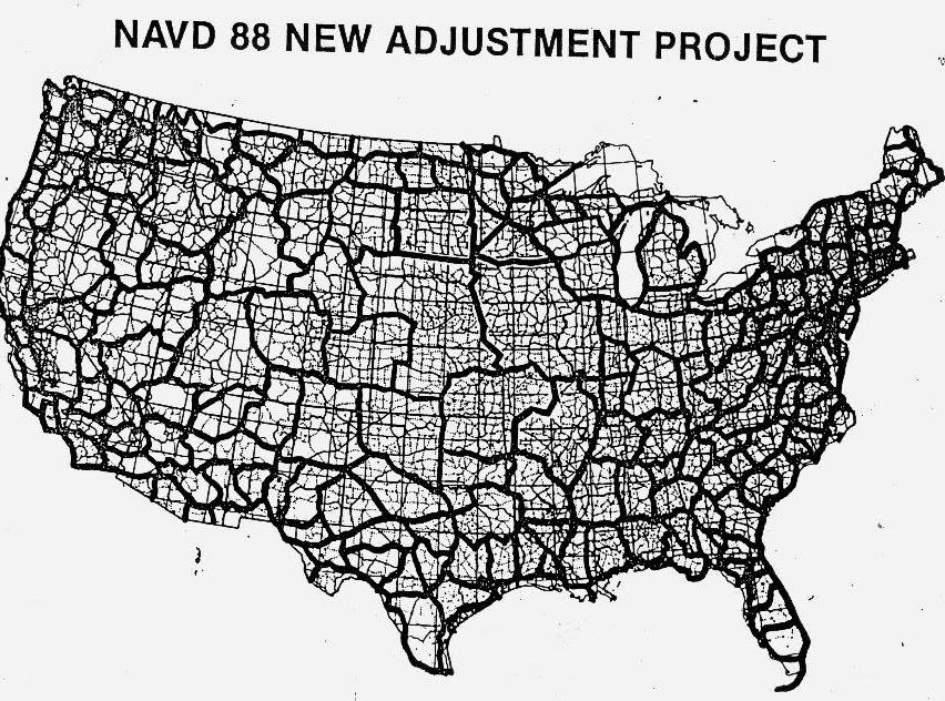
34 NAVD 88 PROGRAM DEFINITION NAVD 88 is a program which combined 1,300,00 kilometers of leveling surveys held in the NGS National Spatial Reference System (NSRS) data base, into a single least squares adjustment to provide users with improved heights for over 500,000 vertical control points distributed throughout the United States, on a common datum. 34
35 35
36 36
37 PRESENT NETWORK FOR NAVD 88 ORIGINAL LEVELING 700,000 KM REPEAT LEVELING 200,000 KM NEW BNA LEVELING 81,500 KM NEW OUTSIDE LEVELING 20,000 KM TOTAL FOR NAVD 88 1,001,500 KM (620,000 MILES) 37

38 38

39 39
40 NEW YORK VERTICAL NETWORK NGVD 29 bench marks ,927 NAVD 88 bench marks ,529 (INCLUDES POSTED DATA) POSTED bench marks Bench marks without NAVD 88 heights * *Includes TBM s, some RESETS, and new marks on lines not included in NAVD 88 general adjustment 40
41 41
42 42
43 43
44 NORTH AMERICALN VERTICAL DATUM OF 1988 (NAVD 88) THE U.S. PORTION OF THE PROJECT INCLUDED THE REMONUMENTATION AND REOBSERVATION OF AN 80,000 KILOMETER SUBSET OF THE VERTICAL CONTROL PORTION OF THE NATIONAL SPATIAL REFERENCE SYSTEM. A MINIMUM-CONSTRAINT LEAST SQUARES ADJUSTMENT OF LEVELING DATA INVOLVING 709,000 MARKS WAS PERFORMED. 44
45 NORTH AMERICAN VERTICAL DATUM OF 1988 (NAVD 88) IN ORDER TO MINIMIZE THE EFFECTS ON USGS NATIONAL MAPPING PRODUCTS (NMPs), AS REQUESTED BY USERS, NGS SELECTED THE NEW INTERNATIONAL GREAT LAKES DATUM OF 1985 (IGLD 85) LOCAL MEAN SEA LEVEL HEIGHT VALUE AT MINIMUM-CONSTRAINT DATUM POINT FOR NAVD 88. THE DATUM POINT IS LOCATED AT THE MOUTH OF THE ST. LAWRENCE RIVER IN QUEBEC, CANADA. USING FATHER POINT/RIMOUSKI AS THE DATUM POINT FOR BOTH IGLD 85 AND NAVD 88 MINIMIZES THE IMPACT ON NMPs, AND ALLOWS NAVD 88 TO REPLACE BOTH NGVD 29 AND IGLD
46 NORTH AMERICAN VERTICAL DATUM OF 1988 (NAVD 88) FISCAL THE GENERAL ADJUSTMENT DID NOT INCLUDE APPROXIMATELY 25 PERCENT OF THE VERTICAL CONTROL NETWORK. BENCH MARKS IN STABLE AREAS WHICH WERE REMOVED FROM THE ADJUSTMENT (DENOTED AS POSTED ) BECAUSE OLDER DATA DID NOT FIT WITH THE LATEST DATA. THIS DATA WAS INCORPORATED INTO THE NAVD 88 DURING YEARS
47 NORTH AMERICAN VERTICAL DATUM OF 1988 (NAVD 88) NAVD 88 DOES NOT CONTAIN USGS, COE, OR STATE DOT THIRD-ORDER LEVELING DATA. USGS PERSONNEL HAVE PERFORMED PILOT STUDIES TO DETERMINE HOW TO BEST INCORPORATE THEIR THIRD- ORDER DATA INTO NAVD 88 (ABOUT A 5-10 YEAR PROGRAM) 47
48 NAVD 88 DATUM DEFINITION Vertical datum based upon an equipotential surface Minimally constrained adjustment held fixed at one point, Father Point/Riouski (Point-au-Pere) 1.3 million kms of leveling data used Heights of 585,000 permanent bench marks estimated. Both orthometric heights and geopotential numbers have been published 48
49 NAVD 88 GENERAL ADJUSTMENT COMPLETION DATE OF JUNE 1991: WHAT DOES THIS REALLY MEAN? The general adjustment of NAVD 88 was completed in June This means that bench marks included in the NAVD 88 Helmert blocking phase (approximately 80 percent of the total) have final adjusted heights available. Bench marks in stable areas which were removed from the adjustment (denoted as POSTed ) because older data did not fit with the latest data was incorporated into NAVD 88 during fiscal years
50 NAVD 88 GENERAL ADJUSTMENT COMPLETION DATE OF JUNE 1991: WHAT DOES THIS REALLY MEAN? Bench marks POSTed in large crustal movement areas, e.g., southern California, Phoenix, Arizona, Houston, Texas, and southern Louisiana was published as special reports after the final adjustment was completed. This is an on-going, long-term task which was started in January It is important to note that some bench marks in crustal movement areas, i.e., bench marks which were included in the NAVD 88 Helmert blocking phase, is available. The heights of these bench marks will be based on the latest available data, but still may be influenced by crustal movement effects. 50
51 Most surveying applications should not be significantly affected because the changes in relative height between adjacent bench marks should be less than 1 cm. As stated above, the absolute height values will change much more, but this should not be a major concern to the surveyor. The greatest problem the surveyor will have is ensuring that all height values of bench marks in the project area are referenced to the same vertical datum, preferably NAVD 88 and labeled correctly (metadata). Other agencies bench marks, e.g., COE, FL Department of Transportation, FL Department of Environmental Protection, and USGS, were incorporated into NAVD 88 by NGS as these agencies provided, and still do, their data in computer-readable form. However, the leveling data associated with over 500,000 third-order bench marks established by USGS have not been placed in computer-readable form and do not have NAVD 88 heights. In addition, COE has established hundreds of thousands of bench marks across the nation which do not have NAVD 88 heights. 51
52 IMPACT OF NAVD 88 Data Bases containing heights referenced to NGVD 29 will have to be updated to NAVD 88 Depending upon the accuracy required, in many areas a Bias Factor could be used for bench marks not included in the readjustment In Moving areas a Bias Factor probably will not be sufficient for most applications 52
53 IMPACT OF NAVD 88 Published Heights of Bench Marks Have Changed Published height values has shifted as much as 5 decimeters In Stable areas, Relative height changes between adjacent bench marks should only be millimeters In Moving areas, Relative height changes have been dependent upon the reasons for the movements. 53
54 IMPACT OF NAVD 88 Maps depicting NGVD 29 Heights will have to be modified for NAVD 88 Heights In many areas a Single Bias Factor, Describing the Difference between NGVD 29 and NAVD 88, could be used for most Mapping Applications In Moving areas, maps depicting the rates of movements will have to be compiled 54
55 REASONS TO CONVERT PRODUCTS TO NAVD 88 Surveys between bench marks will often close better NAVD 88 has provided a better reference to compute GPS-Derived Orthometric Heights 40,000 Additional bench marks of First-Order accuracy is available on NAVD 88 Data and NAVD 88 adjusted height values is readily available and accessible in a convenient format from NGS s web site: Federal Surveying and Mapping agencies will stop publishing on NGVD 29 and will publish only on NAVD 88 Surveys performed for the Federal Government requires the use of NAVD 88 55
56 REASONS TO CONVERT PRODUCTS TO NAVD 88 THE AMERICAN CONGRESS ON SURVEYING AND MAPPING (ACSM) AND THE FEDERAL GEODETIC CONTROL SUBCOMMITTEE (FGCS) RECOMMEND NAVD 88. National Geodetic Survey no longer adjust to NGVD 29 56
57 BENEFITS OF NAVD 88 Improved set of heights on a single vertical datum for North America Improved FGCS Leveling procedures with higher production and lower error rates All NGS National Spatial Reference System data is validated in a single data base, with easy access by users for crustal motion studies, adjustments, latest official heights, and descriptions Removal of height discrepancies caused by inconsistent adjustment constraints 57
58 BENEFITS OF NAVD 88 (CONTINUED) Detection and Removal of height errors due to blunders Minimization of effects of systematic errors in leveling data Replacement of both NGVD 29 and IGLD 55 with a single datum Remonumentation and incorporation of 80,000 km of new leveling data not previously adjusted to NGVD 29 Orthometric Heights compatible with GPS-Derived Orthometric Heights computed using the High-Resolution Geoid Model called Geoid99 58
59 59
60 NAVD 88 IMPLEMENTATION 60
61 NAVD 88 IMPLEMENTATION a Published and distributed NAVD 88 height values b Processed and distributed height values for POSTed data c FGCS Vertical Workgroup input from ACSM Ad Hoc Committee d USGS third-order vertical data e FEMA/National Flood Insurance program 61
62 FGCS VERTICAL WORK GROUP MEMBERS: National Geodetic Survey (Chair) U.S. Geological Survey Federal Highway Administration International Boundary Commission Bureau of Land Management U.S. Army Corps of Engineers U.S. Forest Service Federal Emergency Management Agency 62
63 ACSM AD HOC COMMITTEE GEOGRAPHIC MAKEUP East Coast (Florida to Massachusetts) Gulf Coast Interior Southern States Great Lakes area Plains and Mountain States Pacific Coast (California to Washington) 63
64 ACSM AD HOC COMMITTEE DISCIPLINE MAKEUP Land Surveyors Geodetic Surveyors Mappers ACSM Private Members ACSM Government Members 64
65 FEMA S RESPONSE TO NAVD 88 65
66 FEMA S Response to NAVD 88 Local Mean Sea Level (LMSL) determined at individual tide gages Sea Level Datum (SLD) of 1929 constrained at 26 tide gages in the U.S. and Canada National Geodetic Vertical Datum of 1929 (NGVD 29) renamed from SLD of 1929 to avoid confusion with LMSL North American Vertical Datum of 1988 (NAVD 88) constrained only at Pointe au Pere gage on St. Lawrence River 66
67 FEMA s Response to NAVD 88 FEMA mapped and prepared Flood Insurance Studies (FISs) for thousands of communities with flood elevations vertical reference is the datum as defined by NGS FISs contain flood profiles Flood Insurance Rate Maps (FIRMs) contain flood elevations and Elevation Reference Marks (ERMs) Letters of Map Amendment and Revision (LOMAs and LOMRs) are issued based on elevation comparisons 67
68 FEMA s Response to NAVD 88 FEMA Users Include: Banks and mortgage institutions (lenders) Flood insurance agents Surveyors, engineers, architects, and planners Community floodplain, planning, and zoning officials FEMA Contractors Include: Federal and State water resources agencies Regional water resources commissions Private architectural and engineering firms 68
69 FEMA s Response to NAVD 88 Lenders initiate flood insurance purchase requirement based on FIRMs Surveyors provide Elevation Certificates for flood insurance agents and lenders Community officials enforce floodplain management regulations, which are based on FIS and FIRM Federal contractors must know how and when to implement conversion 69
70 FEMA s Response to NAVD 88 Responsibility of Map Users ensure use of datum consistent with FIS and FIRM Responsibility of FEMA Contractors adherence to FEMA guidelines for conversion documentation of datum used in FIS and FIRM ensure datum consistency throughout FIS and FIRM 70
71 FEMA s Response to NAVD 88 How Will FEMA Accomplish Conversion? Educate staff* Educate contractors* Educate users* Close coordination with NGS *FEMA has published two documents: Appendix 6, Conversion to the North American Vertical Datum 1988 Converting the NFIP to the NAVD 88 71
72 FEMA s Response to NAVD 88 FEMA s Original Plan New Studies - FY 93 FISs (scope of work April 92) Map actions FY 93 as practicable FEMA s Current Proposal Update Appendix 6, Conversion to the NAVD 88 Refine strategy for an orderly transition of FISs and FIRMs to NAVD 88 Gradually convert based on opportunities to republish FISs and FIRMs for other reasons. Ultimate goal is to convert all FISs to NAVD 88 72

73 73
74 74
75 75

76 FEDERAL EMERGENCY MANAGEMENT AGENCY NATIONAL FLOOD INSURANCE PROGRAM ELEVATION CERTIFICATE AND INSTRUCTIONS 76
77 NATIONAL FLOOD INSURANCE PROGRAM ELEVATION CERTIFICATE PAPERWORK REDUCTION ACT NOTICE Public reporting burden for the Elevation Certificate is estimated to average 2.25 hours per response. Burden means the time, effort, or financial resources expended by persons to generate, maintain, retain, disclose, or provide information to the Federal Emergency Management Agency (FEMA). You are not required to respond to the collection of information unless a valid OMB control number is displayed in the upper right corner of each form. You may send comments regarding the accuracy of the burden estimate and any suggestions for reducing the burden to: Information Collections Management, Federal Emergency Management Agency, 500 C Street, SW, Washington, DC 20472, Paperwork Reduction Project ( ). Do not send completed form(s) to the above address. To obtain or retain benefits under the National Flood Insurance Program (NFIP), you must respond to this collection of information. PURPOSE OF THE ELEVATION CERTIFICATE The Elevation Certificate is an important administrative tool of the National Flood Insurance Program (NFIP). It is to be used to provide elevation information necessary to ensure compliance with community floodplain management ordinances, to determine the proper insurance premium rate, and to support a request for a Letter of Map Amendment or Revision (LOMA or LOMR-F). The Elevation Certificate is required in order to properly rate post-firm buildings, which are buildings constructed after publication of the Flood Insurance Rate Map (FIRM), for flood insurance Zones A1-A30, AE, AH, A (with BFE), VE, V1-V30, V (with BFE), AR, AR/A, AR/AE, AR/A1-A30, AR/AH, and AR/AO. The Elevation Certificate is not required for pre-firm buildings unless the building is being rated under the optional post-firm flood insurance rules. As part of the agreement for making flood insurance available in a community, the NFIP requires the community to adopt a floodplain management ordinance that specifies minimum requirements for reducing flood losses. One such requirement is that the community obtain the elevation of the lowest floor (including basement) of all new and substantially improved buildings, and maintain a record of such information. The Elevation Certificate provides a way for a community to comply with this requirement. Use of this certificate does not provide a waiver of the flood insurance purchase requirement. Only a LOMA or LOMR-F from the Federal Emergency Management Agency (FEMA) can amend the FIRM and remove the Federal mandate for a lending institution to require the purchase of flood insurance. However, the lending institution has the option of requiring flood insurance even if a LOMA/LOMR-F has been issued by FEMA. The Elevation Certificate may be used to support a LOMA or LOMR-F request. Lowest floor and lowest adjacent ground elevations certified by a surveyor or engineer will be required if the certificate is used to support a LOMA or LOMR-F request. This certificate is used only to certify building elevations. A separate certificate is required for floodproofing. Under the NFIP, non-residential buildings can be floodproofed up to or above the Base Flood Elevation (BFE). A floodproofed building is a building that has been designed and constructed to be watertight (substantially impermeable to floodwaters) below the BFE. Floodproofing of residential buildings is not permitted under the NFIP unless FEMA has granted the community an exception for residential floodproofed basements. The community must adopt standards for design and construction of floodproofed basements before FEMA will grant a basement exception. For both floodproofed nonresidential buildings and residential floodproofed basements in communities that have been granted an exception by FEMA, a floodproofing certificate is required. 77
78 BUILDING OWNER S NAME FEDERAL EMERGENCY MANAGEMENT AGENCY NATIONAL FLOOD INSURANCE PROGRAM ELEVATION CERTIFICATE Important: Read the instructions on pages 1-7. SECTION A - PROPERTY OWNER INFORMATION O.M.B. No Expires July 31, 2002 For Insurance Company Use: Policy Number BUILDING STREET ADDRESS (Including Apt., Unit, Suite, and/or Bldg. No.) OR P.O. ROUTE AND BOX NO. Company NAIC Number CITY STATE ZIP CODE PROPERTY DESCRIPTION (Lot and Block Numbers, Tax Parcel Number, Legal Description, etc.) BUILDING USE (e.g., Residential, Non-residential, Addition, Accessory, etc. Use Comments section if necessary.) LATITUDE/LONGITUDE (OPTIONAL) HORIZONTAL DATUM: ( ## o - ## - ##.## or ##.##### o ) NAD 1927 NAD 1983 SOURCE: GPS (Type): USGS Quad Map Other: SECTION B - FLOOD INSURANCE RATE MAP (FIRM) INFORMATION B1. NFIP COMMUNITY NAME & COMMUNITY NUMBER B2. COUNTY NAME B3. STATE B4. MAP AND PANEL NUMBER B5. SUFFIX B6. FIRM INDEX DATE B7. FIRM PANEL EFFECTIVE/REVISED DATE B8. FLOOD ZONE(S) B9. BASE FLOOD ELEVATION(S) (Zone AO, use depth of flooding) B10. Indicate the source of the Base Flood Elevation (BFE) data or base flood depth entered in B9. FIS Profile FIRM Community Determined Other (Describe): B11. Indicate the elevation datum used for the BFE in B9: NGVD 1929 NAVD 1988 Other (Describe): B12. Is the building located in a Coastal Barrier Resources System (CBRS) area or Otherwise Protected Area (OPA)? Yes No Designation Date: SECTION C - BUILDING ELEVATION INFORMATION (SURVEY REQUIRED) C1. Building elevations are based on: Construction Drawings* Building Under Construction* Finished Construction *A new Elevation Certificate will be required when construction of the building is complete. C2. Building Diagram Number (Select the building diagram most similar to the building for which this certificate is being completed - see pages 6 and 7. If no diagram accurately represents the building, provide a sketch or photograph.) C3. Elevations Zones A1-A30, AE, AH, A (with BFE), VE, V1-V30, V (with BFE), AR, AR/A, AR/AE, AR/A1-A30, AR/AH, AR/AO Complete Items C3a-i below according to the building diagram specified in Item C2. State the datum used. If the datum is different from the datum used for the BFE in Section B, convert the datum to that used for the BFE. Show field measurements and datum conversion calculation. Use the space provided or the Comments area of Section D or Section G, as appropriate, to document the datum conversion. Datum Conversion/Comments Elevation reference mark used Does the elevation reference mark used appear on the FIRM? Yes No a) Top of bottom floor (including basement or enclosure). ft.(m) b) Top of next higher floor. ft.(m) c) Bottom of lowest horizontal structural member (V zones only). ft.(m) d) Attached garage (top of slab). ft.(m) e) Lowest elevation of machinery and/or equipment servicing the building. ft.(m) f) Lowest adjacent grade (LAG). ft.(m) g) Highest adjacent grade (HAG). ft.(m) h) No. of permanent openings (flood vents) within 1 ft. above adjacent grade i) Total area of all permanent openings (flood vents) in C3h sq. in. (sq. cm) SECTION D - SURVEYOR, ENGINEER, OR ARCHITECT CERTIFICATION This certification is to be signed and sealed by a land surveyor, engineer, or architect authorized by law to certify elevation information. I certify that the information in Sections A, B, and C on this certificate represents my best efforts to interpret the data available. I understand that any false statement may be punishable by fine or imprisonment under 18 U.S. Code, Section CERTIFIER S NAME LICENSE NUMBER TITLE COMPANY NAME 78 ADDRESS CITY STATE ZIP CODE SIGNATURE DATE TELEPHONE License Number, Embossed Seal, Signature, and Date
79 IMPORTANT: In these spaces, copy the corresponding information from Section A. BUILDING STREET ADDRESS (Including Apt., Unit, Suite, and/or Bldg. No.) OR P.O. ROUTE AND BOX NO. CITY STATE ZIP CODE SECTION D - SURVEYOR, ENGINEER, OR ARCHITECT CERTIFICATION (CONTINUED) Copy both sides of this Elevation Certificate for (1) community official, (2) insurance agent/company, and (3) building owner. COMMENTS Check here if attachments SECTION E - BUILDING ELEVATION INFORMATION (SURVEY NOT REQUIRED) FOR ZONE AO and ZONE A (WITHOUT BFE) For Zone AO and Zone A (without BFE), complete Items E1 through E3. If the Elevation Certificate is intended for use as supporting information for a LOMA or LOMR-F, Section C must be completed. E1. Building Diagram Number (Select the building diagram most similar to the building for which this certificate is being completed see pages 6 and 7. If no diagram accurately represents the building, provide a sketch or photograph.) E2. The top of the bottom floor (including basement or enclosure) of the building is ft.(m) in.(cm) above or below (check one) the highest adjacent grade. E3. For Zone AO only: If no flood depth number is available, is the top of the bottom floor elevated in accordance with the community s floodplain management ordinance? Yes No Unknown. The local official must certify this information in Section G. SECTION F - PROPERTY OWNER (OR OWNER S REPRESENTATIVE) CERTIFICATION The property owner or owner s authorized representative who completes Sections A, B, and E for Zone A (without a FEMA-issued or community-issued BFE) or Zone AO must sign here. PROPERTY OWNER S OR OWNER S AUTHORIZED REPRESENTATIVE S NAME ADDRESS CITY STATE ZIP CODE SIGNATURE DATE TELEPHONE COMMENTS SECTION G - COMMUNITY INFORMATION (OPTIONAL) 79 Check here if attachments
80 INSTRUCTIONS FOR COMPLETING THE ELEVATION CERTIFICATE The Elevation Certificate is to be completed by a land surveyor, engineer, or architect who is authorized by law to certify elevation information when elevation information is required for Zones A1-A30, AE, AH, A (with BFE), VE, V1-V30, V (with BFE), AR, AR/A, AR/AE, AR/A1-A30, AR/AH, or AR/AO. Community officials who are authorized by law or ordinance to provide floodplain management information may also complete this form. For Zones AO and A (without BFE), a community official, a property owner, or an owner s representative may provide information on this certificate, unless the elevations are intended for use in supporting a LOMA or LOMR-F. Certified elevations must be included if the purpose of completing the Elevation Certificate is to obtain a LOMA or LOMR-F. In Puerto Rico only, elevations for building information and flood hazard information may be entered in meters. SECTION A - PROPERTY OWNER INFORMATION This section identifies the building, its location, and its owner. Enter the name(s) of the building owner(s), the building s complete street address, and the lot and block number. If the building s address is different from the owner s address, enter the address of the building being certified. If the address is a rural route or a Post Office box number, enter the lot and block numbers, the tax parcel number, the legal description, or an abbreviated location description based on distance and direction from a fixed point of reference. For the purposes of this certificate, building means both a building and a manufactured (mobile) home. A map may be attached to this certificate to show the location of the building on the property. A tax map, FIRM, or detailed community map is appropriate. If no map is available, provide a sketch of the property location, and the location of the building on the property. Include appropriate landmarks such as nearby roads, intersections, and bodies of water. For building use, indicate whether the building is residential, non-residential, an addition to an existing residential or non-residential building, an accessory building (e.g., garage), or other type of structure. Use the Comments area of Section F if needed. If latitude and longitude data are available, enter them in degrees, minutes, and seconds, or in decimal degrees, taken at the center of the front of the building. Enter arc seconds to two decimal places. Indicate the horizontal datum and the source of the measurement data (for example, taken with GPS, scaled from a USGS Quad Map, etc.). SECTION B - FLOOD INSURANCE RATE MAP (FIRM) INFORMATION Complete the Elevation Certificate on the basis of the FIRM in effect at the time of the certification. The information for Section B is obtained by reviewing the FIRM panel that includes the building s location. Information about the current FIRM, and a pamphlet titled Guide to Flood Maps, are available from the Federal Emergency Management Agency (FEMA) website at or by calling If a Letter of Map Amendment (LOMA) or Letter of Map Revision (LOMR-F) has been issued by FEMA, please 80provide the letter date and case number in the Comments area.
81 Item B4. Map and Panel Number. Enter the 10-digit number shown on the FIRM panel where the building or manufactured (mobile) home is located. The first six digits will not match the NFIP community number: 1) when the sixth digit is a C in which case the FIRM panel is in a countywide format; or 2) when one community has annexed land from another community but the FIRM panel has not been updated to reflect this annexation. If the sixth digit is a C, it is followed by a four-digit map number. For maps not in countywide format, enter the community panel number shown on the FIRM. Item B5. Suffix. Enter the suffix letter shown on the FIRM panel that includes the building s location. Item B6. FIRM Index Date. Enter the effective date or map revised date shown on the FIRM Index. Item B7. FIRM Panel Effective/Revised Date. Enter the map effective date or the map revised date shown on the FIRM panel. This will be the latest of all dates shown on the map. The current FIRM panel effective date can be determined by calling Item B8. Flood Zone(s). Enter the flood zone, or flood zones, in which the building is located. All flood zones containing the letter A or V are considered Special Flood Hazard Areas. The flood zones are A, AE, A1-A30, V, VE, V1-V30, AH, AO, AR, AR/A, AR/AE, AR/A1-A30, AR/AH, and AR/AO. Each flood zone is defined in the legend of the FIRM panel on which it appears. Item B9. Base Flood Elevation(s). Using the appropriate Flood Insurance Study (FIS) Profile, Flood Elevation Table, or FIRM panel, locate the property and enter the BFE (or base flood depth) of the building site. If the building is located in more than one flood zone in Item B8, list all appropriate BFEs in Item B9. BFEs are shown on a FIRM or FIS Profile for Zones A1-A30, AE, AH, V1-V30, VE, AR, AR/A, AR/AE, AR/A1-A30, AR/AH, and AR/AO; flood depth numbers are shown for Zone AO. Use the AR BFE if the building is located in any of Zones AR/A, AR/AE, AR/A1-A30, AR/AH, or AR/AO. In A or V zones where BFEs are not provided on the FIRM, the community may have established BFEs or obtained BFE data from other sources. For subdivisions and other developments of more than 50 lots or 5 acres, establishment of BFEs is required by the community s floodplain management ordinance. If the BFE is obtained from another source, enter the BFE in Item B9. Item B10. Indicate the source of the BFE that you entered in Item B9. Item B11. Indicate the elevation datum to which the elevations on the applicable FIRM are referenced. Item B12. Indicate whether the building is located in a Coastal Barrier Resources System (CBRS) area or Otherwise Protected Area (OPA). Federal flood insurance is prohibited in designated CBRS areas for buildings or manufactured (mobile) homes built or substantially improved after the date of the CBRS designation. An information sheet explaining CBRS areas may be obtained on FEMA s website at or by calling SECTION C - BUILDING ELEVATION INFORMATION (SURVEY REQUIRED) Complete Section C if the building is located in any of Zones A1-A30, AE, AH, A (with BFE), VE, V1-V30, V (with BFE), AR, AR/A, AR/AE, AR/A1-A30, AR/AH, 81 or AR/AO, or if this certificate is being used to support a LOMA or LOMR-F. If the building is located in Zone AO or Zone A (without BFE), complete Section E instead.
82 based. Show the datum conversion, if applicable, in this section or in the Comments area of Section D. For property experiencing ground subsidence, the most recently adjusted reference mark elevations must be used for determining building elevations. Enter elevations in Items C3ag to the nearest tenth of a foot (in Puerto Rico, nearest tenth of a meter). Items C3a-d. Enter the building elevations indicated by the selected building diagram (Item C2) in Items C3a-e. Elevation for top of attached garage slab (d) is self-explanatory and is not illustrated in the diagrams. If the building is located in a V zone on the FIRM, complete Item C3c. If the flood zone cannot be determined, enter elevations for all of Items C3a-g. For buildings in A zones, elevations a, b, d, and e should be measured at the top of the floor. For buildings in V zones, elevation c must be measured at the bottom of the lowest horizontal structural member of the floor (see drawing below). If any item does not apply to the building, enter N/A for not applicable. BUILDING ON SLAB BUILDING WITH BASEMENT BUILDING ON PILES, PIERS, OR COLUMNS a A ZONES V ZONES a A ZONES V ZONES A ZONES a c BASE FLOOD ELEVATION c ADJACENT GRADE BASE FLOOD ELEVATION ADJACENT GRADE Item C3e. Enter the lowest elevation of machinery or equipment in an attached garage, enclosure, or open utility platform that provides utility services for the building. If the machinery or equipment is mounted to a wall, pile, etc., enter the platform elevation of the machinery and/or equipment. If this item does not apply to the building, enter N/A for not applicable. Items C3f-g. Adjacent grade is defined as the elevation of the ground, sidewalk, patio, or deck support immediately next to the building. Use the natural grade elevation, if available. This measurement must be to the nearest tenth of a foot if this certificate is being used to support a request for a LOMA or LOMR-F. Items C3h-i. Enter the number of permanent openings (flood vents) in the walls supporting the building that are no higher than 1.0 foot above the adjacent grade. Determine the total area of all such openings in square inches (square cm, in Puerto Rico), and enter the total in Item C3i. If the building has no permanent openings (flood vents) within 1.0 foot above adjacent grade, enter 0 (zero) for each of Items C3h and C3i. SECTION D - SURVEYOR, ENGINEER, OR ARCHITECT CERTIFICATION Complete as indicated. This section of the Elevation Certificate may be signed by only a land surveyor, engineer, or architect who is authorized by law to certify elevation 82 information. Place embossed seal and signature in the box next to elevations in Section C. A flat stamp is acceptable only in states that do not authorize use of an embossed seal over the signature of a professional.
83 SECTION E - BUILDING ELEVATION INFORMATION (SURVEY NOT REQUIRED) FOR ZONE AO & ZONE A (WITHOUT BFE) Complete Section E if the building is located in Zone AO or Zone A (without BFE). Otherwise, complete Section C instead. Item E1. Select the diagram on pages 6 and 7 that best represents the building; then enter the diagram number. If you are unsure of the correct diagram, select the diagram that most closely resembles the building, or provide a sketch or photograph. Item E2. Enter the height in feet and inches (meters and centimeters, in Puerto Rico) of the top of the bottom floor (as indicated in the applicable diagram) above or below the highest adjacent grade (HAG). For post-firm buildings in Zone AO, the community s floodplain management ordinance requires that this value equal or exceed the base flood depth on the FIRM. Buildings in Zone A (without BFE) may qualify for a lower insurance rate if an engineered BFE is developed at the site. Item E3. For those communities where this base flood depth is not available, the community will need to determine whether the top of the bottom floor is elevated in accordance with the community s floodplain management ordinance. SECTION F - PROPERTY OWNER (OR OWNER S REPRESENTATIVE) CERTIFICATION Complete as indicated. This section is provided for certification of measurements taken by a property owner or property owner s representative when responding to Sections A, B, and E. The address entered in this section must be the actual mailing address of the property owner or property owner s representative who provided the information on the certificate. SECTION G - COMMUNITY INFORMATION (OPTIONAL) Complete as indicated. The community official who is authorized by law or ordinance to administer the community s floodplain management ordinance can complete Sections A, B, C (or E), and G of this Elevation Certificate. If the authorized community official completes Sections C, E, or G, complete the appropriate item(s) and sign this section. Check Item G1 if Section C is completed with elevation data from other documentation that has been signed and embossed by a licensed surveyor, engineer, or architect who is authorized by law to certify elevation information. Indicate the source of the elevation data and the date obtained in the Comments area of Section G. If you are both a community official and a licensed land surveyor, engineer, or architect authorized by law to certify elevation information, and you performed the actual survey for a building in Zones A1-A30, AE, AH, A (with BFE), V1-V30, V, AR, AR/A, AR/A1-A30, AR/AE, AR/AH, or AR/AO, you must also complete Section D. Check Item G2 if information is entered in Section E by the community for a building in Zone A (without a FEMA-issued or community-issued BFE) or Zone AO. Check Item G3 if the information in Items G4-G9 has been completed for community floodplain management purposes to document the as-built lowest floor elevation of the building. Section C of the Elevation Certificate records the elevation of various building components but does not determine the lowest floor of the building or whether the building, as constructed, complies with the community s floodplain management ordinance. This must be done 83by the community. Items G4-G9 provide a way to document these determinations.
84 Item G7. New Construction or Substantial Improvement. Check the applicable box. Substantial Improvement means any reconstruction, rehabilitation, addition, or other improvement of a building, the cost of which equals or exceeds 50 percent of the market value of the building before the start of construction of the improvement. The term includes buildings that have incurred substantial damage, regardless of the actual repair work performed. Item G8. As-built lowest floor elevation. Enter the elevation of the lowest floor (including basement) when the construction of the building is completed and a final inspection has been made to confirm that the building is built in accordance with the permit, the approved plans, and the community s floodplain management laws or ordinances. Indicate the elevation datum used. Item G9. BFE. Using the appropriate FIRM panel, FIS, or other data source, locate the property and enter the BFE (or base flood depth) of the building site. Indicate the elevation datum used. Enter your name, title, and telephone number, and the name of the community. Sign and enter the date inthe appropriate blanks. 84


85 BUILDING DIAGRAMS The following eight diagrams illustrate various types of buildings. Compare the features of the building being certified with the features shown in the diagrams and select the diagram most applicable. Enter the diagram number in Item C2 and the elevations in Items C3a-C3g. In A zones, the floor elevation is taken at the top finished surface of the floor indicated; in V zones, the floor elevation is taken at the bottom of the lowest horizontal structural member (see drawing in instructions for Section C). DIAGRAM 1 All slab-on-grade single- and multiple-floor buildings (other than split-level) and high-rise buildings, either detached or row type (e.g., townhouses); with or without attached garage. Distinguishing Feature The bottom floor is at or above ground level (grade) on at least one side. * a GRADE NEXT HIGHER FLOOR BOTTOM FLOOR b DIAGRAM 2 All single- and multiple-floor buildings with basement (other than split-level) and high-rise buildings with basement, either detached or row type (e.g., townhouses); with or without attached garage. Distinguishing Feature The bottom floor (basement or underground garage) is below ground level (grade) on all sides. Buildings constructed above crawl spaces that are below grade on all sides should also use this diagram.* a GRADE NEXT HIGHER FLOOR BOTTOM FLOOR (BASEMENT) b f g (determined by existing grade) f g (determined by existing grade) DIAGRAM 3 All split-level buildings that are slab-on-grade, either detached or row type (e.g., townhouses); with or without attached garage. DIAGRAM 4 All split-level buildings (other than slab-on-grade), either detached or row type (e.g., townhouses); with or without attached garage. Distinguishing Feature The bottom floor (excluding garage) is at or above ground level (grade) on at least one side.* Distinguishing Feature The bottom floor (basement or underground garage) is below ground level (grade) on all sides. Buildings constructed above crawl spaces that are below grade on all sides should also use this diagram. * a GRADE HIGHER FLOORS BOTTOM FLOOR NEXT HIGHER FLOOR b a GRADE HIGHER FLOORS BOTTOM FLOOR (BASEMENT) NEXT HIGHER FLOOR b f g (determined by existing grade) f g (determined by existing grade) * A floor that is below ground level (grade) on all sides is considered a basement even if the floor is used for living purposes, or as an office, garage, workshop, etc. Instructions Page 1 85
86 NGS RESPONSIBILITIES Performed procedures to officially replace NGVD 29 with NAVD 88 Compiled documentation to brief Congress and State officials on NAVD 88 impacts and benefits to minimize problems with uniformed users Provided documentation and publication of NAVD 88 final results 86
87 NGS RESPONSIBILITIES Estimated conversion (bias) shifts between NGVD 29 and NAVD 88 Analyzed bias shift computations to determine where other data, e.g., COE and/or USGS data, may be required (in computer-readable form) to improve the estimate of the bias factor Analyzed the vertical control network to determine local areas where height changes are due to crustal movement 87
88 NGS RESPONSIBILITIES Analyzed the vertical control network to separate bias shifts into components: changes due to datum definition, crustal movement, improved corrections applied to leveling data to account for systematic errors, and removal of adjustment distortions in NGVD 29 Incorporate other data, e.g., COE and/or USGS data, into NAVD 88 (data must be in computer-readable form) Educate NAVD 88 users 88
Datum Issues in the Red River of the North Basin ----
 Datum Issues in the Red River of the North Basin ---- Scoping Document May 1999 Russell E. Harkness, Hydrologist United States Geological Survey Water Resources Division 2 EXECUTIVE SUMMARY Two datum issues
ORDINANCE NO. C-16- WHEREAS, the proposed minimum seawall elevation exceeds the current maximum by 0.7 feet (8.4 inches); and
; and") ORDINANCE NO. AN ORDINANCE AMENDING THE UNIFIED LAND DEVELOPMENT REGULATIONS OF THE CITY OF FORT LAUDERDALE, FLORIDA, AMENDING SECTION 47-19.3, BOAT SLIPS, DOCKS, BOAT DAVITS, HOISTS AND SIMILAR MOORING
ORDINANCE NO. AN ORDINANCE AMENDING THE UNIFIED LAND DEVELOPMENT REGULATIONS OF THE CITY OF FORT LAUDERDALE, FLORIDA, AMENDING SECTION 47-19.3, BOAT SLIPS, DOCKS, BOAT DAVITS, HOISTS AND SIMILAR MOORING
City of Fort Lauderdale. Frequently Asked Questions. Proposed Sea Wall Ordinance
 City of Fort Lauderdale Frequently Asked Questions Proposed Sea Wall Ordinance The City of Fort Lauderdale is considering amending the Unified Land Development Regulations of the City of Fort Lauderdale
U.S. DEPARTMENT OF COMMERCE National Oceanic and Atmospheric Administration National Ocean Service Datums Page Page 1 of 5
 Datums Page Page 1 PRIMARY BENCH MARK STAMPING: 2245 A 1982 866 2245 A TIDAL MONUMENTATION: Tidal Station disk VM#: 16408 AGENCY: National Ocean Survey (NOS) PID#: DD1345 The primary bench mark is a disk
Citrus County, FL Map Modernization Scoping Meeting
 Citrus County, FL Map Modernization Scoping Meeting Lecanto Government Complex April 26, 2007 Definition Flood A general and temporary condition of partial or complete inundation of two or more acres of
Who am I? National Geodetic Survey s Great Lakes Region Geodetic Advisor. John Ellingson Cell:
 Who am I? National Geodetic Survey s Great Lakes Region Geodetic Advisor John Ellingson john.ellingson@noaa.gov Cell: 202-306-6904 Today s Discussion 1st Topic ----- New Datums Coming in 2022 2nd Topic
TANZANIA CIVIL AVIATION AUTHORITY AIR NAVIGATION SERVICES INSPECTORATE. Title: CONSTRUCTION OF VISUAL AND INSTRUMENT FLIGHT PROCEDURES
 Page 1 of 8 1. PURPOSE 1.1. This Advisory Circular provides guidance to personnel involved in construction of instrument and visual flight procedures for publication in the Aeronautical Information Publication.
The Rodman s Guide to Madison Vertical Datums
 The Rodman s Guide to Madison Vertical Datums by Dan Rodman, Wisconsin Professional Land Surveyor No. 2793 City of Madison, WI Parks Division E-mail: drodman@cityofmadison.com Tel: (608)266-6674 Version:
The following criteria shall be applied within the boundaries of the AO District:
 Sec. 419 (a) Purpose AIRPORT OVERLAY DISTRICT (AO) The purpose of the Airport Overlay District is to regulate and restrict the height of structures, objects, or natural growth, regulate the locations of
SUPERSEDED [ U] DEPARTMENT OF TRANSPORTATION. Federal Aviation Administration. 14 CFR Part 39 [66 FR /5/2001]
![SUPERSEDED [ U] DEPARTMENT OF TRANSPORTATION. Federal Aviation Administration. 14 CFR Part 39 [66 FR /5/2001]](/thumbs/89/99040723.jpg "SUPERSEDED [ U] DEPARTMENT OF TRANSPORTATION. Federal Aviation Administration. 14 CFR Part 39 [66 FR /5/2001]") [4910-13-U] DEPARTMENT OF TRANSPORTATION Federal Aviation Administration 14 CFR Part 39 [66 FR 13227 3/5/2001] [Docket No. 2000-NM-416-AD; Amendment 39-12128; AD 2001-04-09] RIN 2120-AA64 Airworthiness
[4910-13-U] DEPARTMENT OF TRANSPORTATION Federal Aviation Administration 14 CFR Part 39 [66 FR 13227 3/5/2001] [Docket No. 2000-NM-416-AD; Amendment 39-12128; AD 2001-04-09] RIN 2120-AA64 Airworthiness
COVER SHEET. Reduced Vertical Separation Minimum (RVSM) Information Sheet Part 91 RVSM Letter of Authorization
 Information Sheet Part 91 RVSM Letter of Authorization") COVER SHEET Reduced Vertical Separation Minimum (RVSM) Information Sheet Part 91 RVSM Letter of Authorization NOTE: FAA Advisory Circular 91-85 ( ), Authorization of Aircraft and Operators for Flight in
COVER SHEET Reduced Vertical Separation Minimum (RVSM) Information Sheet Part 91 RVSM Letter of Authorization NOTE: FAA Advisory Circular 91-85 ( ), Authorization of Aircraft and Operators for Flight in
SUPERSEDED. [Docket No. FAA ; Directorate Identifier 2015-SW-014-AD; Amendment ; AD ]
![SUPERSEDED. [Docket No. FAA ; Directorate Identifier 2015-SW-014-AD; Amendment ; AD ]](/thumbs/95/123244441.jpg "SUPERSEDED. [Docket No. FAA ; Directorate Identifier 2015-SW-014-AD; Amendment ; AD ]") [Federal Register Volume 80, Number 95 (Monday, May 18, 2015)] [Rules and Regulations] [Pages 28172-28175] From the Federal Register Online via the Government Publishing Office [www.gpo.gov] [FR Doc No:
[Federal Register Volume 80, Number 95 (Monday, May 18, 2015)] [Rules and Regulations] [Pages 28172-28175] From the Federal Register Online via the Government Publishing Office [www.gpo.gov] [FR Doc No:
Overview ICAO Standards and Recommended Practices for Aerodrome Mapping Data reported to AIM
 Overview ICAO Standards and Recommended Practices for Aerodrome Mapping Data reported to AIM References ICAO SARPS Annex 14 Vol. I, 7 th Edition, July 2016 ICAO SARPS Annex 15, 15 th Edition, July 2016
Data Origination, Management and WGS 84. ICAO PBN Seminar Data Origination & Management and WGS 84
 Data Origination, Management and WGS 84 1 Learning Objectives Overview Understand the implication of publishing incorrect navigational data in the State s AIP Identify why it is essential to use a common
MAY 2017 AROUND THE BEND. Survey Economics Customers & services. Mobile Scanning Bringing the goods. Black Elk Peak Definitive elevation
 MAY 2017 AROUND THE BEND Survey Economics Customers & services Black Elk Peak Definitive elevation Mobile Scanning Bringing the goods TRUE ELEVATION BLACK ELK PEAK» JERRY PENRY, PS Black Elk Peak, located
Amendment Docket No. FAA ; Directorate Identifier 2010-NM-099-AD
 Page 1 2011-06-09 AIRBUS Amendment 39-16634. Docket No. FAA-2010-1162; Directorate Identifier 2010-NM-099-AD PREAMBLE Effective Date (a) This airworthiness directive (AD) becomes effective April 26, 2011.
[Docket No. FAA ; Directorate Identifier 2012-NM-222-AD; Amendment ; AD ]
![[Docket No. FAA ; Directorate Identifier 2012-NM-222-AD; Amendment ; AD ]](/thumbs/93/111860491.jpg "[Docket No. FAA ; Directorate Identifier 2012-NM-222-AD; Amendment ; AD ]") [Federal Register Volume 80, Number 2 (Monday, January 5, 2015)] [Rules and Regulations] [Pages 153-155] From the Federal Register Online via the Government Printing Office [www.gpo.gov] [FR Doc No: 2014-30428]
[Federal Register Volume 80, Number 2 (Monday, January 5, 2015)] [Rules and Regulations] [Pages 153-155] From the Federal Register Online via the Government Printing Office [www.gpo.gov] [FR Doc No: 2014-30428]
[Docket No. FAA ; Directorate Identifier 2007-NM-291-AD; Amendment ; AD R1]
![[Docket No. FAA ; Directorate Identifier 2007-NM-291-AD; Amendment ; AD R1]](/thumbs/80/81019372.jpg "[Docket No. FAA ; Directorate Identifier 2007-NM-291-AD; Amendment ; AD R1]") Federal Register: January 7, 2008 (Volume 73, Number 4)] [Rules and Regulations] [Page 1052-1055] From the Federal Register Online via GPO Access [wais.access.gpo.gov] [DOCID:fr07ja08-5] DEPARTMENT OF
Federal Register: January 7, 2008 (Volume 73, Number 4)] [Rules and Regulations] [Page 1052-1055] From the Federal Register Online via GPO Access [wais.access.gpo.gov] [DOCID:fr07ja08-5] DEPARTMENT OF
Administration Policies & Procedures Section Commercial Ground Transportation Regulation
 OBJECTIVE METHOD OF OPERATION Definitions To promote and enhance the quality of Commercial Ground Transportation, the public convenience, the safe and efficient movement of passengers and their luggage
Notes on the History of the National Geodetic Vertical Datum 1929 and the North American Vertical Datum 1988 in Alaska, U.S.A. 1
 1 1 2 3 4 5 6 7 8 9 10 11 12 13 14 15 16 17 18 19 20 21 22 23 24 25 26 27 Notes on the History of the National Geodetic Vertical Datum 1929 and the North American Vertical Datum 1988 in Alaska, U.S.A.
PSEG Long Island. Community Distributed Generation ( CDG ) Program. Procedural Requirements
 Program. Procedural Requirements") PSEG Long Island Community Distributed Generation ( CDG ) Program Procedural Requirements Effective Date: April 1, 2016 Table of Contents 1. Introduction... 1 2. Program Definitions... 1 3. CDG Host Eligibility
PSEG Long Island Community Distributed Generation ( CDG ) Program Procedural Requirements Effective Date: April 1, 2016 Table of Contents 1. Introduction... 1 2. Program Definitions... 1 3. CDG Host Eligibility
TRAIL MAPPING AND MARKING POLICY SANTA FE TRAIL ASSOCIATION Adopted by the Santa Fe Trail Association Board of Directors, April 13, 2002
 TRAIL MAPPING AND MARKING POLICY SANTA FE TRAIL ASSOCIATION Adopted by the Santa Fe Trail Association Board of Directors, April 13, 2002 INTRODUCTION There are three principle aspects to the marking of
ANTIDRUG PLAN GUIDANCE
 ANTIDRUG PLAN GUIDANCE This guidance is for your retention. Please do not return it with your plan. Please type or print plan data to minimize errors. 1. Indicate whether this is a new plan or a plan amendment.
M7 AEROSPACE LP
 Page 1 2011-02-04 M7 AEROSPACE LP (TYPE CERTIFICATE PREVIOUSLY HELD BY FAIRCHILD AIRCRAFT INCORPORATED) Amendment 39-16577 Docket No. FAA-2011-0014 Directorate Identifier 2010-CE-066-AD PREAMBLE Effective
COVER SHEET. Reduced Vertical Separation Minimum (RVSM) Information Sheet Part 91 RVSM Letter of Authorization
 Information Sheet Part 91 RVSM Letter of Authorization") COVER SHEET Reduced Vertical Separation Minimum (RVSM) Information Sheet Part 91 RVSM Letter of Authorization NOTE: FAA Advisory Circular 91-85, Authorization of Aircraft and Operators for Flight in Reduced
COVER SHEET Reduced Vertical Separation Minimum (RVSM) Information Sheet Part 91 RVSM Letter of Authorization NOTE: FAA Advisory Circular 91-85, Authorization of Aircraft and Operators for Flight in Reduced
Provincial Railway Technical Standards
 GENERAL: INDEX: The standards and requirements listed in this document are intended for use on provincially regulated railway public grade crossings. These standards are considered the minimum requirements
Amendment of Restricted Areas R-2907A and R-2907B, Lake George, FL; and R-2910, Pinecastle, FL
 This document is scheduled to be published in the Federal Register on 07/03/2013 and available online at http://federalregister.gov/a/2013-16054, and on FDsys.gov 4910-13 DEPARTMENT OF TRANSPORTATION Federal
[Docket No. FAA ; Product Identifier 2017-NM-182-AD; Amendment ; AD ]
![[Docket No. FAA ; Product Identifier 2017-NM-182-AD; Amendment ; AD ]](/thumbs/91/106887793.jpg "[Docket No. FAA ; Product Identifier 2017-NM-182-AD; Amendment ; AD ]") [Federal Register Volume 83, Number 200 (Tuesday, October 16, 2018)] [Rules and Regulations] [Pages 52143-52146] From the Federal Register Online via the Government Publishing Office [www.gpo.gov] [FR
[Federal Register Volume 83, Number 200 (Tuesday, October 16, 2018)] [Rules and Regulations] [Pages 52143-52146] From the Federal Register Online via the Government Publishing Office [www.gpo.gov] [FR
SERVICE INFORMATION LETTER Page: 1 of 2
 SERVICE INFORMATION LETTER Page: 1 of 2 SERVICE INFORMATION LETTER NO. SILD42L-007 13 Sep 12 NOTE: NOTE: NOTE: Service Information Letters (SIL) are used only: 1. To distribute information from Diamond
[Docket No. FAA ; Directorate Identifier 2013-NM-081-AD] Airworthiness Directives; The Boeing Company Airplanes
![[Docket No. FAA ; Directorate Identifier 2013-NM-081-AD] Airworthiness Directives; The Boeing Company Airplanes](/thumbs/95/123065974.jpg "[Docket No. FAA ; Directorate Identifier 2013-NM-081-AD] Airworthiness Directives; The Boeing Company Airplanes") This document is scheduled to be published in the Federal Register on 08/05/2013 and available online at http://federalregister.gov/a/2013-18800, and on FDsys.gov [4910-13-P] DEPARTMENT OF TRANSPORTATION
This document is scheduled to be published in the Federal Register on 08/05/2013 and available online at http://federalregister.gov/a/2013-18800, and on FDsys.gov [4910-13-P] DEPARTMENT OF TRANSPORTATION
DECISION NUMBER NINETEEN TO THE TREATY ON OPEN SKIES
 DECISION NUMBER NINETEEN TO THE TREATY ON OPEN SKIES OSCC.DEC 19 12 October 1994 SUPPLEMENTARY PROVISIONS FOR THE COMPLETION OF THE MISSION PLAN AND FOR THE CONDUCT OF AN OBSERVATION FLIGHT The Open Skies
Amendment Docket No. FAA ; Directorate Identifier 2010-CE-041-AD
 Page 1 2011-02-02 SOCATA Amendment 9-16575 Docket No. FAA-2010-0948; Directorate Identifier 2010-CE-041-AD PREAMBLE Effective Date (a) This airworthiness directive (AD) becomes effective March 1, 2011.
SUPPORT SERVICES GMBH
 Page 1 2011-18-13 328 SUPPORT SERVICES GMBH (TYPE CERTIFICATE PREVIOUSLY HELD BY AVCRAFT AEROSPACE GMBH; FAIRCHILD DORNIER GMBH; DORNIER LUFTFAHRT GMBH) Amendment 39-16795 Docket No. FAA-2010-1163; Directorate
2. CANCELLATION. AC 39-7B, Airworthiness Directives, dated April 8, 1987, is canceled.
 U.S. Department of Transportation Federal Aviation Administration Advisory Circular Subject: AIRWORTHINESS DIRECTIVES Date: 11/16/95 AC No: 39-7C Initiated by: AFS-340 Change: 1. PURPOSE. This advisory
[Docket No. FAA ; Directorate Identifier 2015-CE-017-AD] SUMMARY: The FAA is correcting a notice of proposed rulemaking (NPRM) that
![[Docket No. FAA ; Directorate Identifier 2015-CE-017-AD] SUMMARY: The FAA is correcting a notice of proposed rulemaking (NPRM) that](/thumbs/95/126018770.jpg "[Docket No. FAA ; Directorate Identifier 2015-CE-017-AD] SUMMARY: The FAA is correcting a notice of proposed rulemaking (NPRM) that") This document is scheduled to be published in the Federal Register on 09/04/2015 and available online at http://federalregister.gov/a/2015-21934, and on FDsys.gov [4910-13-P] DEPARTMENT OF TRANSPORTATION
This document is scheduled to be published in the Federal Register on 09/04/2015 and available online at http://federalregister.gov/a/2015-21934, and on FDsys.gov [4910-13-P] DEPARTMENT OF TRANSPORTATION
AERONAUTICAL INFORMATION SERVICES-AERONAUTICAL INFORMATION MANAGEMENT STUDY GROUP (AIS-AIMSG)
") AIS-AIMSG/11-SN/6 20/04/2015 AERONAUTICAL INFORMATION SERVICES-AERONAUTICAL INFORMATION MANAGEMENT STUDY GROUP (AIS-AIMSG) Agenda Item 4: Information Distribution 4.1: AIP ELEVENTH MEETING Montreal, April
AIS-AIMSG/11-SN/6 20/04/2015 AERONAUTICAL INFORMATION SERVICES-AERONAUTICAL INFORMATION MANAGEMENT STUDY GROUP (AIS-AIMSG) Agenda Item 4: Information Distribution 4.1: AIP ELEVENTH MEETING Montreal, April
Alternative Highest & Best Use Analysis Boutique Hotel
 Alternative Highest & Best Use Analysis In response to numerous comments received from the public, as well as issues raised by the CCC in the Appeal Staff Report Substantial Issue Determination, the following
NATA Aircraft Maintenance & System Technology Committee Best Practices. RVSM Maintenance
 NATA Aircraft Maintenance & System Technology Committee Best Practices Reduced Vertical Separation Minimum (RVSM) Airspace reduces the vertical separation above flight level (FL) 290 from 2000-ft minimum
Instructions for Request for Premium Processing Service
 Instructions for Request for Premium Processing Service Department of Homeland Security U.S. Citizenship and Immigration Services USCIS Form I-907 OMB No. 1615-0048 Expires 01/31/2018 What Is the Purpose
[Docket No. FAA ; Product Identifier 2018-NM-117-AD; Amendment ; AD ]
![[Docket No. FAA ; Product Identifier 2018-NM-117-AD; Amendment ; AD ]](/thumbs/92/110001206.jpg "[Docket No. FAA ; Product Identifier 2018-NM-117-AD; Amendment ; AD ]") [Federal Register Volume 83, Number 236 (Monday, December 10, 2018)] [Rules and Regulations] [Pages 63397-63399] From the Federal Register Online via the Government Publishing Office [www.gpo.gov] [FR
[Federal Register Volume 83, Number 236 (Monday, December 10, 2018)] [Rules and Regulations] [Pages 63397-63399] From the Federal Register Online via the Government Publishing Office [www.gpo.gov] [FR
Gas Conversion Kits and Instructions
 Gas Conversion Kits and Instructions INSTALLATION FORM RGM 432/433-GC (Version D.1) Obsoletes Form RGM 432/433-GC (Version D) APPLIES TO: Model FT and Model SFT All gas conversion must be done by a qualified
Consideration will be given to other methods of compliance which may be presented to the Authority.
 Advisory Circular AC 139-10 Revision 1 Control of Obstacles 27 April 2007 General Civil Aviation Authority advisory circulars (AC) contain information about standards, practices and procedures that the
$6.60 NEW SOUTH WALES. Both METRIC and Feet and Inches TIMES: am/pm Sunrise/Sunset Moon Phases Moon Rise/Set DIARY NOTES.
 $6.60 (incl. GST) 2018 2014 November 28, 2013 November 23, 2017 TO to January 2, 7, 2019 2015 Both METRIC and Feet and Inches TIMES: am/pm Sunrise/Sunset Moon Phases Moon Rise/Set DIARY NOTES NEW SOUTH
[Docket No. 93-CE-37-AD; Amendment ; AD R1]
![[Docket No. 93-CE-37-AD; Amendment ; AD R1]](/thumbs/89/99631354.jpg "[Docket No. 93-CE-37-AD; Amendment ; AD R1]") [Federal Register: October 22, 2002 (Volume 67, Number 204)] [Rules and Regulations] [Page 64794-64798] From the Federal Register Online via GPO Access [wais.access.gpo.gov] [DOCID:fr22oc02-4] DEPARTMENT
[Federal Register: October 22, 2002 (Volume 67, Number 204)] [Rules and Regulations] [Page 64794-64798] From the Federal Register Online via GPO Access [wais.access.gpo.gov] [DOCID:fr22oc02-4] DEPARTMENT
(i) Adopted or adapted airworthiness and environmental standards;
 Adopted or adapted airworthiness and environmental standards;") TECHNICAL ARRANGEMENT FOR THE ACCEPTANCE OF AIRWORTHINESS AND ENVIRONMENTAL APPROVAL OF CIVIL AERONAUTICAL PRODUCTS BETWEEN THE CIVIL AVIATION BUREAU, MINISTRY OF LAND, INFRASTRUCTURE AND TRANSPORT, JAPAN
TECHNICAL ARRANGEMENT FOR THE ACCEPTANCE OF AIRWORTHINESS AND ENVIRONMENTAL APPROVAL OF CIVIL AERONAUTICAL PRODUCTS BETWEEN THE CIVIL AVIATION BUREAU, MINISTRY OF LAND, INFRASTRUCTURE AND TRANSPORT, JAPAN
Continuing Airworthiness
 Continuing Airworthiness Objectives To provide an overview of EASA Part M(g) as applicable to CAT operators Continuing Airworthiness Management Organisation approval The Controlled Environment Airworthiness
Appendix 1(a) to JCAR-FCL 1.055
 to JCAR-FCL 1.055") Flying Training Organizations for Pilot licenses and Ratings This guide gives the requirements for the issue, revalidation and variation of the approval of FTOs Introduction 1. A Flying Training Organization
Flying Training Organizations for Pilot licenses and Ratings This guide gives the requirements for the issue, revalidation and variation of the approval of FTOs Introduction 1. A Flying Training Organization
VARIOUS RESTRICTED CATEGORY HELICOPTERS
 Page 1 2012-14-11 VARIOUS RESTRICTED CATEGORY HELICOPTERS Amendment 39-17125 Docket No. FAA-2012-0739; Directorate Identifier 2012-SW-044-AD. PREAMBLE (a) Applicability This AD applies to Arrow Falcon
[Docket No. FAA ; Directorate Identifier 2005-NM-222-AD; Amendment ; AD ]
![[Docket No. FAA ; Directorate Identifier 2005-NM-222-AD; Amendment ; AD ]](/thumbs/96/128211136.jpg "[Docket No. FAA ; Directorate Identifier 2005-NM-222-AD; Amendment ; AD ]") [Federal Register: October 10, 2006 (Volume 71, Number 195)] [Rules and Regulations] [Page 59368-59372] From the Federal Register Online via GPO Access [wais.access.gpo.gov] [DOCID:fr10oc06-4] DEPARTMENT
[Federal Register: October 10, 2006 (Volume 71, Number 195)] [Rules and Regulations] [Page 59368-59372] From the Federal Register Online via GPO Access [wais.access.gpo.gov] [DOCID:fr10oc06-4] DEPARTMENT
NEW SOUTH WALES. Both METRIC and Feet and Inches TIMES: am/pm Sunrise/Sunset Moon Phases Moon Rise/Set DIARY NOTES.
 2016 2014 November 28, 2013 November 26, 2015 TO to January 4, 7, 2017 2015 Both METRIC and Feet and Inches TIMES: am/pm Sunrise/Sunset Moon Phases Moon Rise/Set DIARY NOTES NEW SOUTH WALES Public Works
BOMBARDIER, INC
 Page 1 2010-18-08 BOMBARDIER, INC Amendment 39-16421 Docket No. FAA-2009-1110; Directorate Identifier 2009-NM-116-AD PREAMBLE Effective Date (a) This airworthiness directive (AD) becomes effective October
Runway Roughness Evaluation- Boeing Bump Methodology
 FLIGHT SERVICES Runway Roughness Evaluation- Boeing Bump Methodology Michael Roginski, PE, Principal Engineer Boeing Airport Compatibility Engineering ALACPA XI Seminar, Santiago, Chile September 1-5,
AIRCRAFT SERVICE CHANGE
 AIRCRAFT SERVICE CHANGE NUMBER 909 SUBJECT INDICATING / RECORDING (ATA 31) PLANEVIEW MASTER OPERATING SYSTEM SOFTWARE UPDATE DECEMBER 22, 2011 PILOTS INFORMATION SHEET PLANEVIEW MASTER OPERATING SYSTEM
SAMTRANS TITLE VI STANDARDS AND POLICIES
 SAMTRANS TITLE VI STANDARDS AND POLICIES Adopted March 13, 2013 Federal Title VI requirements of the Civil Rights Act of 1964 were recently updated by the Federal Transit Administration (FTA) and now require
Preliminary Findings of Proposed Alternative
 Preliminary Findings of Proposed Alternative The attached drawing provides a schematic layout of the proposed alternative that will be discussed on July 27, 2010. A full report will follow and should be
Air Operator Certification
 Civil Aviation Rules Part 119, Amendment 15 Docket 8/CAR/1 Contents Rule objective... 4 Extent of consultation Safety Management project... 4 Summary of submissions... 5 Extent of consultation Maintenance
Program Manual. January 1, EarthCraft House Single Family Program. Viridiant 1431 West Main Street Richmond, VA
 Program Manual EarthCraft House Single Family Program January 1, 2017 Viridiant 1431 West Main Street Richmond, VA 23220 804.225.9843 EarthCraft House Project Process Process Overview All EarthCraft Builders
$6.60 NEW SOUTH WALES. Both METRIC and Feet and Inches TIMES: am/pm Sunrise/Sunset Moon Phases Moon Rise/Set DIARY NOTES.
 $6.60 (incl. GST) 2019 2014 November 28, 2013 November 22, 2018 TO to January 1, 7, 2020 2015 Both METRIC and Feet and Inches TIMES: am/pm Sunrise/Sunset Moon Phases Moon Rise/Set DIARY NOTES NEW SOUTH
UC Berkeley Working Papers
 UC Berkeley Working Papers Title The Value Of Runway Time Slots For Airlines Permalink https://escholarship.org/uc/item/69t9v6qb Authors Cao, Jia-ming Kanafani, Adib Publication Date 1997-05-01 escholarship.org
[Docket No. FAA ; Directorate Identifier 2015-NM-124-AD] Airworthiness Directives; The Boeing Company Airplanes
![[Docket No. FAA ; Directorate Identifier 2015-NM-124-AD] Airworthiness Directives; The Boeing Company Airplanes](/thumbs/85/92059879.jpg "[Docket No. FAA ; Directorate Identifier 2015-NM-124-AD] Airworthiness Directives; The Boeing Company Airplanes") This document is scheduled to be published in the Federal Register on 05/13/2016 and available online at http://federalregister.gov/a/2016-11169, and on FDsys.gov [4910-13-P] DEPARTMENT OF TRANSPORTATION
This document is scheduled to be published in the Federal Register on 05/13/2016 and available online at http://federalregister.gov/a/2016-11169, and on FDsys.gov [4910-13-P] DEPARTMENT OF TRANSPORTATION
[Docket No. FAA ; Product Identifier 2016-NM-043-AD; Amendment ; AD ]
![[Docket No. FAA ; Product Identifier 2016-NM-043-AD; Amendment ; AD ]](/thumbs/80/81019200.jpg "[Docket No. FAA ; Product Identifier 2016-NM-043-AD; Amendment ; AD ]") [Federal Register Volume 83, Number 37 (Friday, February 23, 2018)] [Rules and Regulations] [Pages 7975-7979] From the Federal Register Online via the Government Publishing Office [www.gpo.gov] [FR Doc
[Federal Register Volume 83, Number 37 (Friday, February 23, 2018)] [Rules and Regulations] [Pages 7975-7979] From the Federal Register Online via the Government Publishing Office [www.gpo.gov] [FR Doc
Technical Standard Order
 Department of Transportation Federal Aviation Administration Aircraft Certification Service Washington, DC TSO-C145a Effective Date: 09/19/02 Technical Standard Order Subject: AIRBORNE NAVIGATION SENSORS
Boise Municipal Code. Chapter DEFINITIONS
 Chapter 12-03 DEFINITIONS Sections: 12-03-01 ADMINISTRATOR 12-03-02 AIRPORT DESIGNATIONS 12-03-03 AIRPORT HAZARD 12-03-04 AIRPORT HEIGHT LIMITATIONS 12-03-05 AIRPORT REFERENCE POINT 12-03-06 AIRPORT INSTRUMENT
AIRWORTHINESS PROCEDURES MANUAL CHAPTER 26. Modifications and Repairs
 November 2017 Page 1 of 10 CHAPTER 26 1. Introduction Modifications and Repairs 1.1 CAR M states that a person or organisation repairing an aircraft or component should assess the damage against published
R1 BOMBARDIER, INC.
 Page 1 2009-06-05 R1 BOMBARDIER, INC. Amendment 39-16217 Docket No. FAA-2009-1021; Directorate Identifier 2009-NM-054-AD PREAMBLE Effective Date (a) This airworthiness directive (AD) becomes effective
IRELAND SAFETY REGULATION DIVISION
 NOTICE TO AIR NAVIGATION SERVICE PROVIDERS IRELAND SAFETY REGULATION DIVISION NR S.016 ISSUE 1 DATE 03.03.10 IRISH AVIATION AUTHORITY AVIATION HOUSE HAWKINS STREET DUBLIN 2 Tel +353 1 6718655 Fax +353
Advisory Circular. Canada and United States Bilateral Aviation Safety Agreement Maintenance Implementation Procedures
 Advisory Circular Subject: Issuing Office: Canada and United States Bilateral Aviation Safety Agreement Maintenance Implementation Procedures Aircraft Maintenance and Manufacturing Activity Area: Rulemaking
Initiated By: AFS-400
 U.S. Department of Transportation Federal Aviation Administration Advisory Circular Subject: Development and Submission of Special Date: 04/14/2015 AC No: 90-112A Instrument Procedures to the FAA Initiated
GENERAL ADVISORY CIRCULAR
 GENERAL CIVIL AVIATION AUTHORITY OF BOTSWANA ADVISORY CIRCULAR CAAB Document GAC-002 ACCEPTABLE FLIGHT SAFETY DOCUMENTS SYSTEM GAC-002 Revision: Original August 2012 PAGE 1 Intentionally left blank GAC-002
Amendment Docket No. FAA ; Directorate Identifier 2007-NM-260-AD
 Page 1 2009-20-05 AIRBUS Amendment 39-16028 Docket No. FAA-2007-0390; Directorate Identifier 2007-NM-260-AD PREAMBLE Effective Date (a) This airworthiness directive (AD) becomes effective November 3, 2009.
REIMS AVIATION S.A.
 Page 1 2011-07-03 REIMS AVIATION S.A. Amendment 39-16640 Docket No. FAA-2011-0058; Directorate Identifier 2010-CE-071-AD PREAMBLE Effective Date (a) This airworthiness directive (AD) becomes effective
CHAPTER 5 AEROPLANE PERFORMANCE OPERATING LIMITATIONS
 CHAP 5-1 CHAPTER 5 PERFORMANCE OPERATING LIMITATIONS 5.1 GENERAL 5.1.1 Aeroplanes shall be operated in accordance with a comprehensive and detailed code of performance established by the Civil Aviation
AIRWORTHINESS ADVISORY CIRCULAR
 AAC No. 1 of 2017 Dated 28 th February 2017 GOVERNMENT OF INDIA CIVIL AVIATION DEPARTMENT DIRECTOR GENERAL OF CIVIL AVIATION AIRWORTHINESS ADVISORY CIRCULAR Subject: Procedure for approval of Modification
BOMBARDIER, INC.
 Page 1 2010-04-12 BOMBARDIER, INC. Amendment 39-16205 Docket No. FAA-2009-0712; Directorate Identifier 2007-NM-152-AD PREAMBLE Effective Date (a) This airworthiness directive (AD) is effective April 8,
Supersedes: AD3V (991) AD3V (1294)
 AD3V (1294)") APPLICATION DATA VENTING TABLES CATEGORY I, CENTRAL FURNACES Supersedes: 650.64-AD3V (991) 650.69-AD3V (1294) SIZING OF VENTING SYSTEMS SERVING APPLIANCES EQUIPPED WITH DRAFT HOODS, CATEGORY I APPLIANCES
APPLICATION DATA VENTING TABLES CATEGORY I, CENTRAL FURNACES Supersedes: 650.64-AD3V (991) 650.69-AD3V (1294) SIZING OF VENTING SYSTEMS SERVING APPLIANCES EQUIPPED WITH DRAFT HOODS, CATEGORY I APPLIANCES
This document is meant purely as a documentation tool and the institutions do not assume any liability for its contents
 2010R0073 EN 20.10.2014 001.001 1 This document is meant purely as a documentation tool and the institutions do not assume any liability for its contents B COMMISSION REGULATION (EU) No 73/2010 of 26 January
Draft Concept Alternatives Analysis for the Inaugural Airport Program September 2005
 Draft Concept Alternatives Analysis for the Inaugural Airport Program September 2005 Section 3 - Refinement of the Ultimate Airfield Concept Using the Base Concept identified in Section 2, IDOT re-examined
CHG 0 9/13/2007 VOLUME 2 AIR OPERATOR AND AIR AGENCY CERTIFICATION AND APPLICATION PROCESS
 VOLUME 2 AIR OPERATOR AND AIR AGENCY CERTIFICATION AND APPLICATION PROCESS CHAPTER 5 THE APPLICATION PROCESS TITLE 14 CFR PART 91, SUBPART K 2-536. DIRECTION AND GUIDANCE. Section 1 General A. General.
USE OF RADAR IN THE APPROACH CONTROL SERVICE
 USE OF RADAR IN THE APPROACH CONTROL SERVICE 1. Introduction The indications presented on the ATS surveillance system named radar may be used to perform the aerodrome, approach and en-route control service:
[Docket No. FAA ; Directorate Identifier 2005-NM-056-AD; Amendment ; AD ]
![[Docket No. FAA ; Directorate Identifier 2005-NM-056-AD; Amendment ; AD ]](/thumbs/90/103474126.jpg "[Docket No. FAA ; Directorate Identifier 2005-NM-056-AD; Amendment ; AD ]") [Federal Register: June 7, 2006 (Volume 71, Number 109)] [Rules and Regulations] [Page 32811-32815] From the Federal Register Online via GPO Access [wais.access.gpo.gov] [DOCID:fr07jn06-3] DEPARTMENT OF
[Federal Register: June 7, 2006 (Volume 71, Number 109)] [Rules and Regulations] [Page 32811-32815] From the Federal Register Online via GPO Access [wais.access.gpo.gov] [DOCID:fr07jn06-3] DEPARTMENT OF
Comparison Between Old and New ALUC Plans
 A P P E N I X H Comparison Between Old and New ALUC Plans OVERVIEW This Placer County Airport Land Use Compatibility Plan (ALUCP) sets forth land use compatibility criteria for the environs of Auburn Municipal,
ADVISORY CIRCULAR AC-AD-005
 GHANA CIVIL AVIATION AUTHORITY ADVISORY CIRCULAR AC-AD-005 AERODROME QUALITY DATA SYSTEM GENERAL Ghana Civil Aviation Authority (GCAA) Advisory Circulars from Aerodrome Safety and Standards (ASAS) contain
AVIATION PLANNING AND DEVELOPMENT Oakland International Airport 530 Water Street Oakland, CA 94607
 AVIATION PLANNING AND DEVELOPMENT Oakland International Airport 530 Water Street When Do I Need to File an FAA Form 7460-1? Objects Affecting Navigable Airspace (14CFR77) June 2013 Background The Federal
NIAGARA MOHAWK POWER CORPORATION. Procedural Requirements
 NIAGARA MOHAWK POWER CORPORATION Procedural Requirements Initial Effective Date: November 9, 2015 Table of Contents 1. Introduction 2. Program Definitions 3. CDG Host Eligibility Provisions 4. CDG Host
The type rating of test pilots having flown the aircraft for its development and certification needs to be addressed as a special case.
 FLIGHT TESTING: COMMENTS ON NPA 2008-17,PILOT LICENSING FCL.700 Circumstances in which class or type ratings are required Subparagraph (b) (b) Notwithstanding paragraph (a), in the case of flights related
Adding your Aircraft to a 14CFR 135 Operating Certificate
 Adding your Aircraft to a 14CFR 135 Operating Certificate Adding your aircraft to an existing 14CFR 135 operating certificate doesn t need to be difficult. The most important thing is to know and understand
Overview ICAO Standards and Recommended Practices for Aerodrome Safeguarding
 Overview ICAO Standards and Recommended Practices for Aerodrome Safeguarding References The Convention on International Civil Aviation (Chicago Convention) ICAO SARPS Annex 14 Vol. I, 7 th Edition, July
AERONAUTICAL SURVEYS & INSTRUMENT FLIGHT PROCEDURES
 AERONAUTICAL SURVEYS & INSTRUMENT FLIGHT PROCEDURES Current as of November 2012 ALASKA AVIATION SYSTEM PLAN UPDATE Prepared for: State of Alaska Department of Transportation & Public Facilities Division
Testimony. of the. National Association of Mutual Insurance Companies. to the. United States House of Representatives
 Testimony of the National Association of Mutual Insurance Companies to the United States House of Representatives Committee on Small Business, Subcommittee on Investigations, Oversight and Regulations
RECOMMENDED FIELD APPROVAL APPLICATION Portland Flight Standards District Office
 RECOMMENDED FIELD APPROVAL APPLICATION Portland Flight Standards District Office I. Instructions: Print or type all entries. This information should be as complete as possible prior to your initial submission
Certificate of Release to Service (CRS)
") AIRWORTHINESS NOTICE Certificate of Release to Service (CRS) No 4 Issue 3 August 2010 1 Introduction 1.1 This Airworthiness Notice sets out to provide the necessary framework under which Certificate of
AIRWORTHINESS NOTICE Certificate of Release to Service (CRS) No 4 Issue 3 August 2010 1 Introduction 1.1 This Airworthiness Notice sets out to provide the necessary framework under which Certificate of
SUPERSEDED. [Docket No NM-217-AD; Amendment ; AD ]
![SUPERSEDED. [Docket No NM-217-AD; Amendment ; AD ]](/thumbs/84/90683100.jpg "SUPERSEDED. [Docket No NM-217-AD; Amendment ; AD ]") [4910-13-U] DEPARTMENT OF TRANSPORTATION Federal Aviation Administration 14 CFR Part 39 [65 FR 82901 12/29/2000] [Docket No. 2000-NM-217-AD; Amendment 39-12054; AD 2000-26-04] RIN 2120-AA64 Airworthiness
[4910-13-U] DEPARTMENT OF TRANSPORTATION Federal Aviation Administration 14 CFR Part 39 [65 FR 82901 12/29/2000] [Docket No. 2000-NM-217-AD; Amendment 39-12054; AD 2000-26-04] RIN 2120-AA64 Airworthiness
Subpart H. 2042/2003
 AIRWORTHINESS NOTICE Issue of Certificate of Airworthiness No 12 Issue 3 May 2014 1 Purpose and scope The Civil Aviation Directive CAD-AIRW/8(1)-1 incorporates the Annex Part 21 to the European Commission
K SIGNAGE & TRAFFIC CONTROL. Table of Contents
 Table of Contents K1. ACCOMMODATION OF TRAFFIC... 1 K2. MINIMUM CONSTRUCTION SIGNING... 1 K3. SUBDIVISION SIGNS... 2 K4. TRAFFIC CONTROL DEVICES... 2 K4.1 Traffic Signs Regulations... 2 K4.2 Materials...
CHAPTER 61 SHEBOYGAN COUNTY MEMORIAL AIRPORT
 61.01 OPERATION OF AIRPORT 61.02 DEFINITION OF WORDS AND PHRASES 61.03 AIRPORT OPERATION POLICIES 61.04 UTILITIES 61.05 ENTRANCES 61.06 SPECIAL VARIANCE 61.07 ENFORCEMENT 61.08 PENALTY 61.09 MULTIPLE OWNERSHIP
[Docket No. FAA ; Product Identifier 2017-NM-164-AD; Amendment ; AD ]
![[Docket No. FAA ; Product Identifier 2017-NM-164-AD; Amendment ; AD ]](/thumbs/85/92086732.jpg "[Docket No. FAA ; Product Identifier 2017-NM-164-AD; Amendment ; AD ]") [Federal Register Volume 83, Number 172 (Wednesday, September 5, 2018)] [Rules and Regulations] [Pages 45041-45044] From the Federal Register Online via the Government Publishing Office [www.gpo.gov] [FR
[Federal Register Volume 83, Number 172 (Wednesday, September 5, 2018)] [Rules and Regulations] [Pages 45041-45044] From the Federal Register Online via the Government Publishing Office [www.gpo.gov] [FR
Fly Quiet Report. 3 rd Quarter November 27, Prepared by:
 November 27, 2017 Fly Quiet Report Prepared by: Sjohnna Knack Program Manager, Airport Noise Mitigation Planning & Environmental Affairs San Diego County Regional Airport Authority 1.0 Summary of Report
USE OF 3D GIS IN ANALYSIS OF AIRSPACE OBSTRUCTIONS
 USE OF 3D GIS IN ANALYSIS OF AIRSPACE OBSTRUCTIONS A project by by Samuka D. W. F19/1461/2010 Supervisor; Dr D. N. Siriba 1 Background and Problem Statement The Airports in Kenya are the main link between
[Docket No. FAA ; Product Identifier 2018-CE-012-AD; Amendment ; AD ]
![[Docket No. FAA ; Product Identifier 2018-CE-012-AD; Amendment ; AD ]](/thumbs/82/86252562.jpg "[Docket No. FAA ; Product Identifier 2018-CE-012-AD; Amendment ; AD ]") [Federal Register Volume 83, Number 66 (Thursday, April 5, 2018)] [Rules and Regulations] [Pages 14568-14574] From the Federal Register Online via the Government Publishing Office [www.gpo.gov] [FR Doc
[Federal Register Volume 83, Number 66 (Thursday, April 5, 2018)] [Rules and Regulations] [Pages 14568-14574] From the Federal Register Online via the Government Publishing Office [www.gpo.gov] [FR Doc
[Docket No. FAA ; Directorate Identifier 2005-CE-34-AD; Amendment ; AD ]
![[Docket No. FAA ; Directorate Identifier 2005-CE-34-AD; Amendment ; AD ]](/thumbs/87/96769658.jpg "[Docket No. FAA ; Directorate Identifier 2005-CE-34-AD; Amendment ; AD ]") [Federal Register: December 12, 2005 (Volume 70, Number 237)] [Rules and Regulations] [Page 73355-73358] From the Federal Register Online via GPO Access [wais.access.gpo.gov] [DOCID:fr12de05-4] DEPARTMENT
[Federal Register: December 12, 2005 (Volume 70, Number 237)] [Rules and Regulations] [Page 73355-73358] From the Federal Register Online via GPO Access [wais.access.gpo.gov] [DOCID:fr12de05-4] DEPARTMENT