St. Louis District Mobility
|
|
|
- Scott Houston
- 5 years ago
- Views:
Transcription


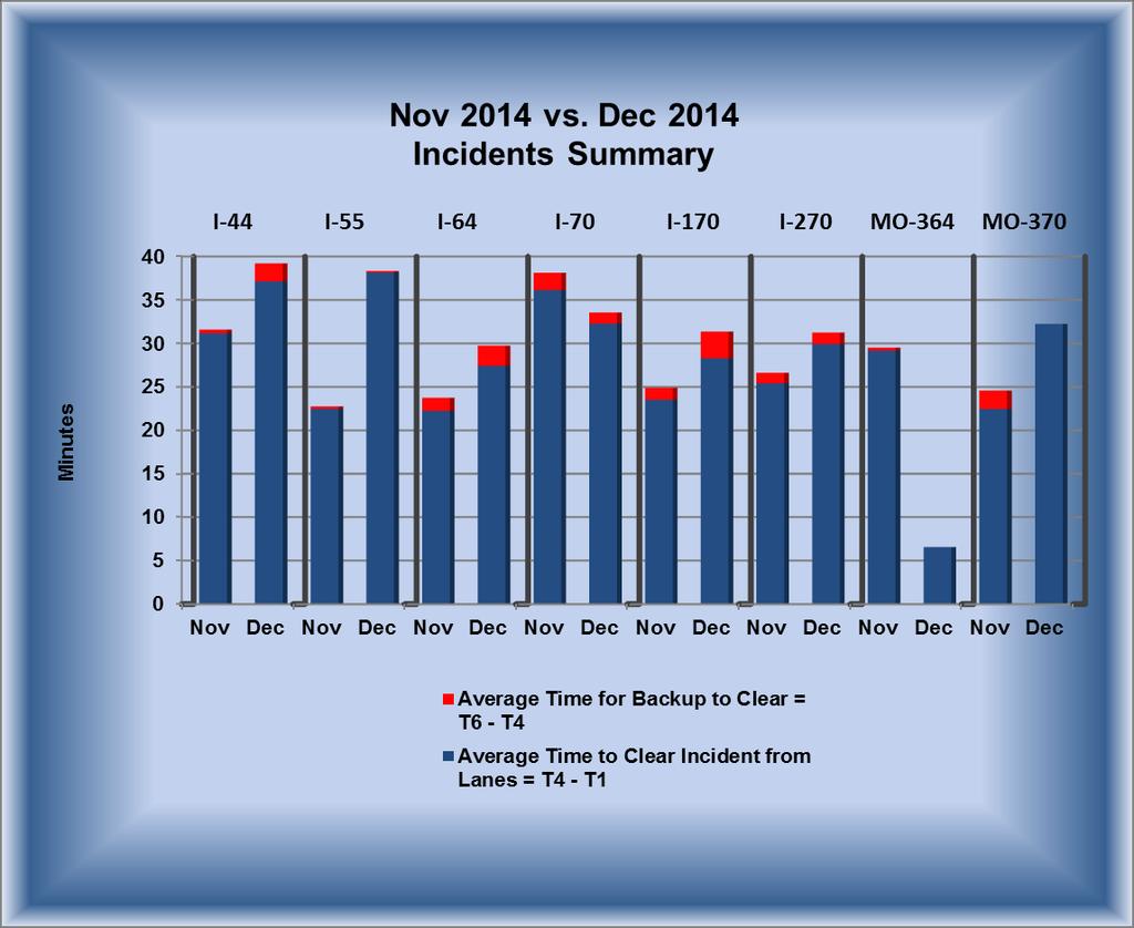
1 St. Louis District Mobility December 2014 GuidePost Freeway mobility declined with heavy volumes slowing travel on stretches of I-64 / I-70 / I-270 December Freeway volumes increased by 4.7% from 2013 to 2014 and annual volumes increased 2.6% from 2013 to 2014 Arterial Peak period Travel flowed well except for slowing along routes at interstate interchanges in both peaks with overall slower PM travel 379 emergency responders were trained on Safe, Quick Incident Lane clearance during 16 Traffic Incident Management classes throughout 2014 Winter Weather, a wrong-way driver and a pedestrian strike among the 10 Major incidents MoDOT s Incident Management Coordinator, Owen hasson, provides Traffic Incident Management (TIM) training to emergency responders from DOT, Police, Fire, EMS, Public Works and Tow. Mobility Snapshot Freeway Mobility Declined compared to previous month Freeway Average 24 hour Volumes Dec 2013 Dec 2014: Up 4.7% : Up 2.6% Major Incidents Nov 2014: 4 Dec 2014: Avg Avg. 5.9 ZONING IN TMS Work Zones DEC 2013: 211 DEC 2014: 205 Work Zone breakdown: Major: 0 0 % Moderate: 0 0% Minor: % Work zone crashes: 3 Average Incident Duration NOV DEC Lane Clearance: 27:32 31:34 Incident Clearance: 28:23 32:29 (Min: sec) Major Impact Work Zones November 0 December 0 Moderate Impact Work Zones November 2 December 0 Year to Year Mobility Comparison: DEC 2013 DEC 2014 Major impact WZ: Improved Moderate impact WZ: Improved Major incidents: Increased Freeway Mobility: Improved Trending UP Gateway Guide Transportation Management Center

2 Work Zones TMC Observed Work Zones December 2014 Level of Travel Time Impact Number of Work Zones Major Impact 0 Moderate Impact 0 Minor Impact 163 Total 163 *Impact Levels described in Data Key SL Mobility Rating: Nov 2014: 97% Dec 2014: 96% Goal: 91% SL Visibility levels: Nov 2014: 91% Dec 2014: 95% Goal: 91% Major Impact (15 Minutes or Above Additional Travel Time ***NONE*** Moderate Impact (10-14 Minutes Additional Travel Time) ***NONE*** Work Zone Related Crashes with Mobility Impact ***NONE*** 2

3 Work Zones Location of Crash Relative to Work Zone 2013 Totals 2014 Totals Advanced Warning Area 8 17 Transition Area Activity Area Termination Area 1 1 TMA Hit 8 10 Total Work Zone Crashes Work Zone History Totals 2014 Totals Major Travel Impact Work Zones Moderate Travel Impact Work Zones 14 9 Work Zone Crashes Minor Travel Impact Work Zones TMC Observed Work Zones Total Work Zones TMS

4 Incident Management 4

5 Oct Nov Dec Incident Management December 2014 Incidents Map Westbound I-70 at Cypress Road Westbound I-270 at Lindbergh Boulevard Southbound I-170 to Westbound I-70 Eastbound I-270 past Riverview Drive Westbound I-70 at Lucas and Hunt Road Westbound I-44 past Jefferson Avenue Northbound I-55 at Park Avenue Eastbound I-44 before Six Flags Road Legend Northbound I-55 before Route 141 Eastbound I-44 past Route 47 Incidents Crashes Number of Incidents Denotes Location of Major Impact Traffic Incidents Number of Incidents Interstate I I I I I I Mo Mo Total Number of Major Impact Incidents November 2014 vs. December 2014 (4) (10) Number of Fatal Incidents November 2014 vs. December 2014 (2) (6) Number of Tractor Trailer Incidents November 2014 vs. December 2014 (33) (38) 5
6 Incident Management Major Impact Traffic Incidents and Mitigation 12/1/2014 (Monday) Time: 4:10 am 9:54 am ***Weather Related*** Location: St. Louis County Eastbound I-44 before Six Flags Road Event: Single-Vehicle Tractor Trailer Crash Estimated Initial Impact: Rush Hour: 3 of 3 travel lanes affected equals (=) 100% Action: Motorist Assist responded along with MSHP, emergency responders and Miners Towing. The TMC messaged for the event using roadside messaging and alerts advising motorists of the closure. The EOC, Community Relations and Motor carriers were notified. Result: A tractor trailer jackknifed and crashed into the guard rail damaging 12 posts and 40 foot of guardrail before overturning and blocking all eastbound lanes. I-44 was shut down and traffic was diverted off at exit 256 onto Old Route 66. Traffic queued for 3 miles during this event heavily impacting the am rush. The roadway was treated with salt before the decision was made to open up lanes one and two, but keep lane three closed at the accident scene. At 7:45 am the engineer on duty was notified of the incident and began arterial mitigation based on the description from on-site. Signals were adjusted at the ramp from Eastbound I-44 to West Osage Street. Camera views of West Osage Street Business Loop I-44(BL I-44), which runs parallel with I-44, indicated BL I-44 was congested due to traffic diverting away from I-44. With no pre-programmed diversion plan available, some quick adjustments to the 3-signal BL I- 44 system (Lamar Parkway, Viaduct and Payne) were made in an attempt to relieve some of the congestion through Pacific until motorists could get back onto Eastbound I-44 at Allenton/Six Flags. The timing plan was changed to a plan with a cycle length of 120 seconds. Further adjustments were also made to help the off-ramp diverting traffic. At Payne and Routes FF-OO the signals were put to free operation and max time for mainline was locked in and increased to help flush as many vehicles eastward. The adjustments helped improve the flow of traffic on BL I-44 to get through the city limits of Pacific. The additional time provided for the ramp at Lamar intersection allowed a few more vehicles to get off the interstate each cycle. With such a large volume of traffic being diverted it was still over capacity and adjustments never fully relieved the backup on Eastbound I-44. Eastbound I-44 was reopened at 8:30 am. Congestion on Osage was clear by 8:50 am and signals were put back to normal operation by 9:00 am. Event Duration: 5 hours 44 minutes Eastbound I-44 before Six Flags Road Left Shoulder Lane 1 Lane 2 Lane 3 Right Shoulder Closed Hours/Minutes 4:26 4:37 3:37 4:16 4:19 6
 75%. Action: MoDOT Emergency Responders, St.")
7 Incident Management Major Impact Traffic Incidents and Mitigation 12/1/2014 (Monday) Time: 6:29 am 9:08 am ***Weather Related*** Location: St. Louis County Westbound I-70 at Lucas and Hunt Road Event: Two-Vehicle Crash Estimated Initial Impact: Rush Hour 3 of 4 travel lanes affected, equals (=) 75%. Action: MoDOT Emergency Responders, St. John Police, and a tow responded to the event. TMC posted alerts and advanced warning messages advising motorists of closure to slow down for icy conditions. Result: Crash closed lanes 1 and 2 with responders closing lane 3. Time of day, icy conditions and police not wanting to move vehicles to shoulder despite no injuries contributed to lengthy clearance time. The crash caused a 3 mile queue at onset that had grown to an 8 mile backup when lanes were opened. Traffic did not return to normal flow until 9:46 am (38 minutes after lanes cleared). Event Duration: 2 hours 39 minutes Westbound I-70 at Lucas and Hunt Road Left Shoulder Lane 1 Lane 2 Lane 3 Lane 4 Right Shoulder Closed Hours/Minutes 2:36 2:36 2:36 1:32 0:00 1:10 7
 100%.")
8 Incident Management Major Impact Traffic Incidents and Mitigation 12/1/2014 (Monday) Time: 7:51 am 12:02 pm ***Weather Related*** Location: St. Louis City Eastbound I-270 past Riverview Drive Event: Single-Vehicle Overturned Fuel Tanker Estimated Initial Impact: Rush Hour 2 of 2 travel lanes affected, equals (=) 100%. Action: MoDOT Emergency Responders, MSHP, St. Louis City Fire, and a tow responded to the event. TMC posted advance warning messages advising motorists of closure and to slow down for icy conditions. Result: Overturned fuel tanker loaded with approximately 2,000 gallons of gasoline that had to be recovered. Fuel was transferred to a secondary tanker before tow could upright the vehicle. No fuel was spilled and the vehicle was removed from the roadway with no additional hazards. Traffic was diverted off of the interstate at Bellefontaine Road and Route 367. Event Duration: 4 hours 11 minutes Eastbound I-270 at Riverview Drive Lane 1 Lane 2 Right Shoulder Closed Hours/Minutes 4:16 1:58 0:01 8
9 Incident Management Major Impact Traffic Incidents and Mitigation 12/13/2014 (Saturday) Time: 7:01 am 5:53 pm Location: Jefferson County Northbound I-55 before Route 141 Event: Single-Vehicle Tractor Trailer Crash Estimated Initial Impact: Non-Rush Hour 3 of 6 travel lanes affected, equals (=) 50%. Action: MoDOT Emergency Responders, MoDOT Bridge Maintenance, Arnold Police, and multiple tows responded to the event. TMC posted advance warning messages advising motorists of closure. Result: Crash occurred on Northbound I-55 at the Church Street overpass (just south of Route 141). Driver lost control, left the roadway on the right side, went up the embankment striking the overpass, sheering the top from the trailer and coming to rest in the grassy area on the right of the roadway. Although the incident was of considerable length, the lanes were only blocked sporadically to allow for adjustments of the tow trucks. Five tow trucks (2 heavy-duty / 3 lightduty), were used to move/load the tractor and trailer. Once the vehicle was loaded onto a flatbed it was determined that it was too heavy to move. The trailer was then offloaded. Because the overpass was struck at a high rate of speed, bridge maintenance was called out to inspect. No damage was found. Traffic continued to move without queuing. Event Duration: 10 hours 52 minutes Northbound I-55 before Route 141 Left Shoulder Lane 1 Lane 2 Lane 3 Lane 4 Lane 5 Right Exit Right Shoulder Closed Hours/Minutes 0:00 0:00 0:00 0:00 0:10 5:22 5:18 10:42 9
 100%. Action: MoDOT Emergency Responders and Maintenance, MSHP, Fire, EMS and Tow responded.")
10 Incident Management Major Impact Traffic Incidents and Mitigation 12/16/2014 (Tuesday) Time: 5:54 am 10:15 am ***Fatal*** Location: Franklin County Eastbound I-44 past Route 47 Event: Pedestrian Struck by Vehicle Estimated Initial Impact: Rush Hour: 2 of 2 travel lanes affected, equals (=) 100%. Action: MoDOT Emergency Responders and Maintenance, MSHP, Fire, EMS and Tow responded. The TMC posted web alert messages warning motorists of closure and notified EOC, Motor Carriers, Community Relations and MoDOT Incident Management Coordinator. Result: A pedestrian was fatally struck by a vehicle. All lanes of Eastbound I-44 were closed for investigation. Traffic was diverted at the off ramp east of St. Clair, and advised to use Route 47 North to US 50 East. There was a 3 mile queue at onset that eased to 1 mile after 25 minutes. Maintenance responded to assist with traffic control and provided updated reports to the TMC as this event was not viewable by camera. Event Duration: 4 hours 21 minutes Eastbound I-44 past Route 47 Left Shoulder Lane 1 Lane 2 Right Shoulder Closed Hours/Minutes 4:08 4:08 4:20 4:20 10
11 Incident Management Major Impact Traffic Incidents and Mitigation 12/19/2014 (Friday) Time: 1:56 am 6:39 am ***Fatal*** Location: St. Louis County Westbound I-270 at Lindbergh Boulevard Event: Two-Vehicle Crash Estimated Initial Impact: Non-Rush Hour: 3 of 3 travel lanes affected, equals (=) 100%. Action: MoDOT Emergency Responders and Maintenance, MSHP, Hazelwood Police, Fire and EMS, St. Louis County Medical examiner and Bolin Tow responded. The TMC posted web alert messages warning motorists of closure and notified Area Engineer, EOC, Motor Carriers, Community Relations and MoDOT Incident Management Coordinator. Result: A car attempted to enter the traffic lanes after being stopped on the right shoulder and pulled into the path of a tractor trailer. The car was pinned against the median wall resulting in the driver being fatally injured. The tractor trailer driver was transported to the hospital with injuries. All lanes were closed for extrication and crash reconstruction with a queue of 2 miles. Maintenance was called in and provided traffic control. Traffic was diverted off I-270 at the US 67 slip ramp. No queue except during pickup of traffic control as rush hour began. Event Duration: 4 hours 42 minutes Westbound I-270 at Lindbergh Boulevard Lane 1 Lane 2 Lane 3 Right Shoulder Closed Hours/Minutes 4:08 4:08 4:08 4:39 11
 100%.")
12 Incident Management Major Impact Traffic Incidents and Mitigation 12/21/2014 (Sunday) Time: 4:15 am 8:06 am ***Fatal*** Location: St. Louis City Northbound I-55 at Park Avenue Event: Wrong-Way Driver Two-Vehicle Crash Estimated Initial Impact: Rush Hour: 4 of 4 travel lanes affected, equals (=) 100%. Action: MoDOT Emergency Responders and Maintenance, St. Louis City Police, Fire, EMS, Coroner and Tow responded. The TMC posted web alert messages warning motorists of closure and notified EOC, Motor Carriers, Community Relations and MoDOT Incident Management Coordinator. Result: A wrong-way driver driving south in the Northbound I-55 lanes struck a northbound vehicle resulting in a double fatality. All northbound lanes were closed for reconstruction. Driver was believed to have entered the interstate from Walnut Street. Traffic control was handled by MoDOT maintenance and traffic was forced off I-55 at Park Avenue and advised to seek alternate route into downtown from I-44 and I-55. There was a 2 minute queue when all lanes were opened. Event Duration: 3 hours 51 minutes Northbound I-55 at Park Avenue Left Shoulder Lane 1 Lane 2 Lane 3 Lane 4 Right Shoulder Closed Hours/Minutes 3:47 3:47 3:44 3:44 3:43 3:41 12
 75%.")
13 Incident Management Major Impact Traffic Incidents and Mitigation 12/23/2014 (Tuesday) Time: 1:28 pm 3:43 pm Location: St. Louis City Westbound I-44 past Jefferson Avenue Event: Multi-Vehicle Crash Estimated Initial Impact: Non-Rush Hour: 3 of 4 travel lanes affected, equals (=) 75%. Action: MoDOT Emergency Responders and Maintenance, St. Louis City Police, Fire, EMS and Tow responded. The TMC posted web alert messages warning motorists of closure and notified EOC, Motor Carriers, Community Relations and MoDOT Incident Management Coordinator. Result: Crash closed two left lanes and knocked over a barrier wall. Three people were transported for injuries. Traffic was able to move around the incident with no queue. Maintenance responded with a boom truck to lift and reset the barrier wall. Event Duration: 2 hours 15 minutes Westbound I-44 past Jefferson Avenue Left Shoulder Lane 1 Lane 2 Lane 3 Lane 4 Right Shoulder Closed Hours/Minutes 2:15 2:15 0:51 0:00 0:00 0:06 13
 100%.")

14 Incident Management Major Impact Traffic Incidents and Mitigation 12/27/2014 (Saturday) Time: 4:28 am 7:05 am ***Fatal*** Location: St. Louis County Southbound I-170 to Westbound I-70 Event: Single-Vehicle Crash Estimated Initial Impact: Non-Rush Hour: 1 of 1 travel lanes affected, equals (=) 100%. Action: MoDOT Emergency Responders, MSHP, Berkeley Police, Fire, EMS St. Louis County Medical Examiner, and A2B Towing responded. The TMC posted web alert messages warning motorists of closure and to seek alternate route. MoDOT Incident Management Coordinator was notified. Result: Crash involved a van that traveled off the left side of the roadway, struck a ditch and overturned. Driver was ejected from vehicle resulting in a single fatality. No reconstruction took place. The exit opened as soon as recovery was complete. No queue observed. Traffic was diverted east on I-70 and able to turn around on Natural Bridge Road to go west on I-70. Event Duration: 2 hours 37 minutes Southbound I-170 to Westbound I-70 Left Exit Lane 1 Right Exit Closed Hours/Minutes 2:37 2:37 2:37 14
15 Incident Management Major Impact Traffic Incidents and Mitigation 12/29/2014 (Monday) Time: 8:48 pm 12:11 am ***Fatal*** Location: St. Louis County Westbound I-70 at Cypress Road Event: Pedestrian Struck Estimated Initial Impact: Non-Rush Hour: 4 of 4 travel lanes affected, equals (=) 100%. Action: MoDOT Emergency Responders, Bridgeton, Cool Valley and Normandy Police, Northeast Fire and Ambulance, Pattonville Fire, St. Louis County Medical Examiner and Tow responded. The TMC posted web alert messages warning motorists of closure and to seek alternate route. TMC notified EOC, Motor Carriers, Community Relations and MoDOT Incident Management Coordinator. Result: Pedestrian fatally struck while trying to cross Westbound I-70 at Cypress Road. All westbound lanes and one eastbound lane were closed during the investigation. Motorist Assist helped to provide traffic control. The eastbound closure lasted just over an hour. There was a half mile queue from the onset eventually backing up to Airflight Road as traffic exited in a single file off I-70 at Natural Bridge Road. There was no queue when the incident terminated. Event Duration: 3 hours 23 minutes Westbound I-70 at Cypress Road Left Shoulder Lane 1 Lane 2 Lane 3 Lane 4 Right Shoulder Closed Hours/Minutes 3:15 2:54 2:47 2:48 2:48 2:48 15

16 Freeway Management AM Peak Changes in December 2014 A C D Mobility Declined B Mobility Remained Low *All weekdays are included in speed index calculation 16
17 Freeway Management 9 12 MO 30/ Gravois Rd


18 Freeway Management 9 12 W/O Timberlake Manor W/O McCausland

19 Freeway Management PM Peak Changes in November 2014 A B Mobility Remained Low *All weekdays are included in speed index calculation 19


20 Freeway Management 12 Lindbergh Blvd Maryville Centre


21 Freeway Management W/O Hampton 12 W/O US


22 Freeway Management Readings from every detector on the interstates in the St. Louis District are used for this comparison. An average 24 hour volume value is determined for each route and direction per month. The average values are then combined for a total 24 hour volume. The values presented represent the number of vehicles on the district s interstates on the average weekday for each month. 22
23 Arterial Management 23

24 Arterial Management 24
25 Arterial Management Arterial Mitigation 12/8/14 Monday Location: Eastbound I-44 at Jefferson Event: Multiple vehicle crash resulted in a full closure of the intestate. Time: 4:20 pm to 5:20 pm Total Time: 1 hour Action: A multiple vehicle crash was observed around 4:00 pm on Eastbound I-44 at the Jefferson Avenue overpass. The I-44 Eastbound traffic was using the left shoulder to bypass it for about 30 minutes after the crash, until the Fire Department and the Police closed the eastbound direction completely to work on the incident. This resulted in a backup on Eastbound I-44 stretching past Vandeventer/Kingshighway. The Eastbound I-44 at Jefferson ramp signal was set to run the AM peak to flush the down-and-over traffic trying to bypass the closure and get back on Eastbound I-44. Result: This noticeably helped drivers that were able to make it to the off-ramp at Jefferson. Looking at the Eastbound I-44 ramp signal at Grand, many drivers were trying to get off there. No adjustments were made however, due to the peak plan in effect and tight signal spacing. Around 5:30 pm one lane was open and the traffic started to move very slowly again. By about 5:45 pm the Grand Eastbound on-ramp was noticed to be clearing up. 25
26 10/1 10/8 10/15 10/22 10/29 11/5 11/12 11/19 11/26 12/3 12/10 12/17 12/24 12/31 Number of Devices Responsding Arterial Management ITS Devices On Line th Quarter Date 100% Target Efforts highlighted in this report such as data collection, incident management by the TMC, and DMS messaging all depend on a reliable communication network throughout the District in order to use CCTV cameras, data sensors, and DMS s. Each workday, a scan of the network is undertaken in order to determine how many devices are communicating back to the TMC. The chart above and associated milestones show the trends of those scans and the effects certain events have on the health of the network and in turn the ability to utilize ITS devices. October 16: Single radio failure on Route 30 December 1: Failures over long Thanksgiving weekend quickly repaired in first 2 days December 15: Fiber damage on Route 180 and near Boone Bridge, plus outage on Route 100, resulted in 180 devices down 26
27 Data Key Work Zones Whenever additional travel time is reported, this additional time shall be evaluated using this chart and adequate mitigation measures should begin within the parameters of this chart. TMC and field personnel are partners in the mitigation of traffic and notification of additional travel times should trigger the appropriate response from both parties. Chart is designed to be an additional travel time reference to establish parameters for gauging the travel impact through work zones and to provide guidance for taking mitigation actions. Travel times can be collected or reported via Blue Toad technology, field personnel, call reports, ITS, TMC cameras, etc. Major and Moderate impacts trigger an IAR (Immediate Action Required) event. IAR means work zone user and TMC partner together to take immediate actions to reduce or eliminate distress. During an IAR event mitigation procedures can range from increased driver notification up to and including removal of work zone. Additional mitigation procedures may require involvement of administration through use of the work zone resolution ladder. Level of Impact Major (Red) IAR Event SEVERE DISTRESS PRESENT Return of roadway to free flow traffic is Priority #1 Moderate (Yellow) IAR Event CAUTIONARY STAGE: Action required by Field/ TMC to prevent escalation to a major event Additional Travel Time Expected 15 minutes or above TMC and field personnel take all steps possible up to and including removal of lane closure to achieve free flow threshold minutes TMC increases driver messaging. Field begins efforts to restore free flow traffic Mitigation Actions Immediate Action Required Supervisory mitigation assistance is required using the St. Louis District Work Zone Resolution Ladder as a tool to restore free flow traffic threshold TMC and field shall reach a consensus on mitigation success within 15 minutes or less. If a consensus cannot be reached, mitigation should be scaled upwards in accordance with the St. Louis District Work Zone Resolution Ladder 27

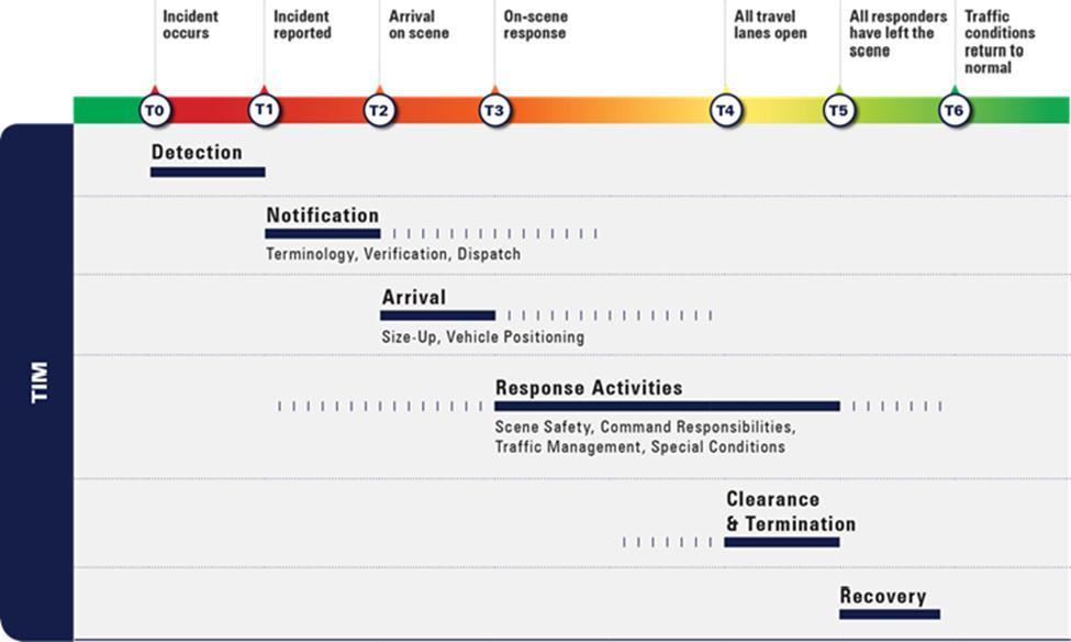
28 Data Key Incident Levels Major Impact Traffic Incident Road closure > 2 hours Major traffic incidents are typically traffic incidents involving hazardous materials, fatal traffic crashes involving numerous vehicles, and other natural or man-made disasters. These traffic incidents typically involve closing all or part of a roadway facility for a period exceeding 2 hours. Moderate Impact Traffic Incident Blocked travel lanes/closure 30 min 2 hours Moderate traffic impact incidents typically affect travel lanes for a time period of 30 minutes to 2 hours, and usually require traffic control on the scene to divert road users past the blockage. Full roadway closures might be needed for short periods during traffic incident clearance to allow traffic incident responders to accomplish their tasks. Minor Impact Traffic Incident Lane closures < 30 minutes Minor traffic incidents are typically disabled vehicles and minor crashes that result in lane closures of less than 30 minutes. On-scene responders are typically law enforcement and towing companies, and occasionally highway agency service patrol vehicles. Worst Time to Travel Clocks - The clocks found on the speed charts depict the progression of travel speeds during the commute peak period at the worst congestion location along the route. - For example, the clock on the left depicts conditions worsening at a particular location beginning at 6:30 a.m. with the slowest speeds between 7 a.m. and 8:15 a.m. Conditions improved at 8:45 a.m. Definitions 511 Gateway Guide s phone line for automated call-in travel information in the St. Louis Metro Area 511 Floodgate Message Road closure message sent from the TMC that is read at the beginning of a 511 call and posted to the banner on the website ACTRA Traffic signal management software program Alert message sent regarding an incident or event on the roadway Arterial Missouri State Highway Numbered Routes, not fully access controlled Arterial Device ITS equipment located along MoDOT arterials Average Minutes per Mile Number of minutes for a vehicle to travel one mile of roadway averaged over a section of roadway BlueTOAD - a (Bluetooth Travel-time Origination and Destination) traffic monitoring system to collect high quality high density travel times by sampling a portion of actual travel times 28
29 Data Key DMS - Dynamic Message Signs along highway displaying incident and travel time information Defined Sensor A single sensor with an individual ID focused on a particular roadway; multiple defined sensors may be located at one physical sensor location Driver messaging Messages placed on DMS boards to alert drivers of incidents ahead of their direction of travel EOC Emergency Operations Center operated by MoDOT in Jefferson City ER MoDOT s Emergency Response units that provide emergency assistance during nights and weekends typically not covered by Motorist Assist units Freeway Device ITS device located along a MoDOT freeway, such as interstates and other fully access controlled highways Gatewayguide.com Gateway Guide s website for local St. Louis area traffic information GuidePost Area of report highlighting important mobility topics for the month IDOT - Illinois Department of Transportation KC Scout Gateway Guide s counterpart for the greater Kansas City Metropolitan area, a collaboration involving both MoDOT and the Kansas DOT Mobility Ease of movement over roadway, through system, and or work zone MMU Conflict monitor hardware installed at a signal system MRB Mississippi River Bridge under construction north of downtown St. Louis Observed Work zone Work zone tracked by traffic cameras at the TMC Peak Average Daily speed sensor readings over an entire weekday rush commute period averaged for an entire month PSB - Poplar Street Bridge Regional Mobility Overview Map depicting congestion areas based on speed index ratings derived from speed sensor readings Speed Index a ratio of the speed at which vehicles travel during a period to the speed at free-flow conditions Stats to Watch Area of report highlighting interesting trends for the report month, or data to be closely followed STLtraffic group consisting of Gateway Guide personnel and Gateway Guide s media partners, messages sent to the group are also posted on Twitter TMC Traffic Management Center (also referred to as Gateway Guide) TMC Alert alert sent to an internal group of Gateway Guide personnel 29
30 Data Key VDS Video Detection System, signal equipment used to detect vehicles at an intersection Visibility- Concerning placement of traffic signs, signals, devices, barricades and warning lights for safety within work zone or construction area to help motorist and workers move within a work zone safely; Clearly visible and legible, distinguishable to approaching traffic during day and night, aligned with road user s line of vision, and positioned as to not obstruct other applicable traffic control devices. Must meet MUTCD standards for condition and must be covered, turned or properly stowed when not in use. Zoning In section of report highlighting important construction topics for the report month 30
31 Data Key I-70 Mile Markers ST. CHARLES COUNTY 5TH ST SOUTH (ST. CHARLES) 229A 5TH ST NORTH (ST. CHARLES) 229B ST. LOUIS COUNTY BLANCHETTE BRIDGE 230 EARTH CITY EXPRESSWAY SOUTH 231A EARTH CITY EXPRESSWAY NORTH 231B I MCKELVEY RD OVERPASS (BRIDGETON) 233 RTE 180/ST. CHARLES ROCK RD (BRIDGETON 234 US 67 SOUTH (BRIDGETON) US 67 NORTH (BRIDGETON) CYPRESS RD (BRIDGETON) AIRFLIGHT (ST. ANN) MCDONNELL OVERPASS (BERKELEY) LAMBERT AIRPORT (BERKELEY) I-170 NORTH (BERKELEY) I-170 SOUTH (BERKELEY) NORTH HANLEY (BERKELEY) RTE N/FLORISSANT RD (COOL VALLEY) BERMUDA DR (NORMANDY) RTE U/LUCAS AND HUNT RD JENNINGS STATION RD (PINE LAWN) ST. LOUIS CITY GOODFELLOW (ST. LOUIS) RIVERVIEW/BIRCHER (ST. LOUIS) UNION (ST. LOUIS) KINGSHIGHWAY (ST. LOUIS) SHREVE (ST. LOUIS) WEST FLORISSANT AVE (ST LOUIS) NORTH BROADWAY (ST. LOUIS) ADELAIDE (ST LOUIS) GRAND (ST. LOUIS) SALISBURY (ST LOUIS) BRANCH (ST LOUIS) MADISON (ST LOUIS) PINE ST OVERPASS (ST LOUIS) CHESTNUT ST OVERPASS (ST LOUIS) MARKET ST OVERPASS (ST. LOUIS) WALNUT ST OVERPASS (ST LOUIS) 235A 235B 235C A 238B 238C A 240B 241B 242C 243A 243B 244A 244B 245A 245B 246A 246B A 248B 249A I-70 DISTRICT 6 WESTBOUND I-70 DISTRICT 6 EASTBOUND 229A 229B A 231B A 235B 235C A 238B 238C A 240B 241B 242C 243A 243B 244A 244B 245A 245B 246A 246B A 248B 249A ST. CHARLES COUNTY 5TH ST SOUTH (ST. CHARLES) 5TH ST NORTH (ST. CHARLES) ST. LOUIS COUNTY BLANCHETTE BRIDGE EARTH CITY EXPRESSWAY SOUTH EARTH CITY EXPRESSWAY NORTH I-270 MCKELVEY RD OVERPASS (BRIDGETON) RTE 180/ST. CHARLES ROCK RD (BRIDGETON US 67 SOUTH (BRIDGETON) US 67 NORTH (BRIDGETON) CYPRESS RD (BRIDGETON) AIRFLIGHT (ST. ANN) MCDONNELL OVERPASS (BERKELEY) LAMBERT AIRPORT (BERKELEY) I-170 NORTH (BERKELEY) I-170 SOUTH (BERKELEY) NORTH HANLEY (BERKELEY) RTE N/FLORISSANT RD (COOL VALLEY) BERMUDA DR (NORMANDY) RTE U/LUCAS AND HUNT RD JENNINGS STATION RD (PINE LAWN) ST. LOUIS CITY GOODFELLOW (ST. LOUIS) RIVERVIEW/BIRCHER (ST. LOUIS) UNION (ST. LOUIS) KINGSHIGHWAY (ST. LOUIS) SHREVE (ST. LOUIS) WEST FLORISSANT AVE (ST LOUIS) NORTH BROADWAY (ST. LOUIS) ADELAIDE (ST LOUIS) GRAND (ST. LOUIS) SALISBURY (ST LOUIS) BRANCH (ST LOUIS) MADISON (ST LOUIS) PINE ST OVERPASS (ST LOUIS) CHESTNUT ST OVERPASS (ST LOUIS) MARKET ST OVERPASS (ST. LOUIS) WALNUT ST OVERPASS (ST LOUIS) 31
32 Data Key I-70 St. Charles County Mile Markers RTE A (WENTZVILLE) RTE A (WENTZVILLE) LAKE ST. LOUIS BLVD (LAKE ST. LOUIS) LAKE ST. LOUIS BLVD (LAKE ST. LOUIS) BRYAN RD (O'FALLON) BRYAN RD (O'FALLON) RTE K/RTE M (O'FALLON) T.R. HUGHES BLVD (O'FALLON) RTE 79 (ST. PETERS/O'FALLON) RTE C/MID RIVERS MALL DR (ST. PETERS) SPENCER RD OVERPASS (ST. PETERS) RTE 370 (ST. PETERS) CAVE SPRINGS (ST. CHARLES) ZUMBEHL RD (ST. CHARLES) HAWK'S NEST OVERPASS (ST. CHARLES) RTE 94 (ST. CHARLES) I-70 DISTRICT 6 EASTBOUND I-70 DISTRICT 6 WESTBOUND RTE K/RTE M (O'FALLON) T.R. HUGHES BLVD (O'FALLON) RTE 79 (ST. PETERS/O'FALLON) RTE C/MID RIVERS MALL DR (ST. PETERS) SPENCER RD OVERPASS (ST. PETERS) RTE 370 (ST. PETERS) CAVE SPRINGS (ST. CHARLES) ZUMBEHL RD (ST. CHARLES) HAWK'S NEST OVERPASS (ST. CHARLES) RTE 94 (ST. CHARLES) 5TH ST SOUTH (ST. CHARLES) 229A 229A 5TH ST SOUTH (ST. CHARLES) 5TH ST NORTH (ST. CHARLES) 229B 229B 5TH ST NORTH (ST. CHARLES) 32
33 Data Key I-270 Mile Markers 3 2 1C 1B C A 25B A 31B KOCH RD SR 231 (TELEGRAPH RD) US61-67 I-55 NORTH I-55 SOUTH SR 21 (TESSON FERRY RD.) SR 30 (GRAVOIS RD.) I-44 EAST/SR 366 (WATSON RD.) I-44 WEST DOUGHERTY FERRY RD. SR 100 (MANCHESTER RD.) I-64 EAST/WEST/US NORTH/SOUTH SR AB (LADUE RD) SR 340 (OLIVE BLVD) SR D (PAGE AVE.) EAST SR 364 WEST DORSETT RD I-70 WEST/EAST SR 180 (ST. CHARLES ROCK RD) MISSOURI BOTTOM RD/370 WEST MCDONNELL BLVD US 67 SOUTH US 67 NORTH HANLEY/GRAHAM RD. I-170 SOUTH NEW FLORISSANT RD WASHINGTON/ELIZABETH RD. WEST FLORISSANT RD SR AC HALLS FERRY RD SR 367 SOUTH SR 367 NORTH BELLEFONTAINE RD LILAC AVE. RIVERVIEW DR. I-255 WESTBOUND --- > I-270 DISTRICT 6 CLOCKWISE FROM I-55 TO RIVERVIEW DR. --- > I-255 EASTBOUND <--- I-270 DISTRICT 6 COUNTER CLOCKWISE FROM RIVERVIEW DR. TO I-55 <--- KOCH RD SR 231 (TELEGRAPH RD) US61-67 I-55 NORTH I-55 SOUTH SR 21 (TESSON FERRY RD.) SR 30 (GRAVOIS RD.) I-44 EAST I-44 WEST BIG BEND RD. DOUGHERTY FERRY RD. SR 100 (MANCHESTER RD.) I-64 EAST/WEST/US NORTH/SOUTH SR AB (LADUE RD) SR 340 (OLIVE BLVD) SR D (PAGE AVE.) EAST SR 364 WEST DORSETT RD I-70 WEST I-70 EAST SR 180 (ST. CHARLES ROCK RD) SR 370 WEST MCDONNELL BLVD US 67 NORTH US 67 SOUTH I-170 SOUTH (EXIT LEFT) HANLEY/GRAHAM NEW FLORISSANT RD ELIZABETH/WASHINGTON WEST FLORISSANT RD SR AC NEW HALLS FERRY RD NEW HALLS FERRY RD. SR 367 SOUTH SR 367 NORTH BELLEFONTAINE RD LILAC AVE. RIVERVIEW DR B 1B 1A A/B A 16B 17 20B 20A 20C 22D 23 25A 25B 26A 26B A 31A 31B
34 Data Key I-64 Mile Markers I-70 WEST EXIT RIGHT/EAST EXIT LEFT 1 1A I-70 WEST 1B I-70 EAST PROSPECT RD 1C 1C PROSPECT RD LAKE ST. LOUIS BLVD 2 2 LAKE ST. LOUIS BLVD SR N 4 4 MO N SR DD/WINGHAVEN 6 6 MO DD/Winghaven SR K/SR MO K 10 MO 94 MISSOURI RESEARCH PARK/TECHNOLOGY DR RESEARCH PARK CRL DANIEL BOONE BRIDGE DANIEL BOONE BRIDGE CHESTERFIELD AIRPORT RD SPIRIT OF ST LOUIS BLVD 16 LONG RD BOONE S CROSSING BOONE S CROSSING CHESTERFIELD PKWY 19A 19A CHESTERFIELD PKWY SR 340 (OLIVE/CLARKSON 19B 19B MO 340 (OLIVE/CLARKSON) 20 CHESTERFIELD PKWY TIMBERLAKE MANOR PKWY TIMBERLAKE MANOR PKWY SR MO 141 (WOODS MILL RD) MASON RD I-270 SOUTH I-270 NORTH SR JJ (BALLAS RD) SPOEDE RD US A 25B A I-64 DISTRICT 6 WESTBOUND I-64 DISTRICT 6 EASTBOUND A 25B A MARYVILLE CENTRE DR MASON RD I-270 SOUTH I-270 NORTH MO JJ (BALLAS RD) SPOEDE RD US B CLAYTON RD MCKNIGHT RD MCKNIGHT RD BRENTWOOD/HANLEY RD 31B 31A I-170 NORTH I-170 NORTH 31A 31B HANLEY RD/BRENTWOOD BLVD BELLEVUE AVE 33B BIG BEND 33A 33A BIG BEND BLVD MCCAUSLAND 33C ST. LOUIS CITY ST. LOUIS CITY 33C MCCAUSLAND AVE HAMPTON AVE/OAKLAND AVE 34B 34A CLAYTON RD/SKINKER BLVD 34B HAMPTON AVE KINGSHIGHWAY 36A 36A KINGSHIGHWAY VANDEVENTER AVE 36C 36B BOYLE MARKET ST/BERNARD ST 37A GRAND AVE 37B JEFFERSON AVE 38A 38A FOREST PARK AVE/GRAND BLVD CHESTNUT AT 20TH ST 38B 38B MARKET ST AT 3000 WEST 14TH ST 39B 39A MARKET ST AT 21ST 11TH ST EXIT LEFT 39C 40A STADIUM/9TH ST/ TUCKER BLVD BROADWAY/7TH ST (LAST MISSOURI EXIT) 40B 40C I-44 WB/I-55 SB/ I-70 WB 34
35 Data Key I-55 Mile Markers JEFFERSON COUNTY JEFFERSON COUNTY RTE M RTE M MAIN ST(IMPERIAL) MAIN ST(IMPERIAL) RICHARDSON RD (ARNOLD) RICHARDSON RD (ARNOLD) RTE 141 (ARNOLD) RTE 141 (ARNOLD) ST. LOUIS COUNTY ST. LOUIS COUNTY MERAMEC BOTTOM RD MERAMEC BOTTOM RD BUTLER HILL RD 195 I-255 EAST 196A I-270 NORTH 196B US67/LINDBERGH 197 REAVIS BARRACKS RD 199 UNION RD 200 BAYLESS 201A WEBER RD 201B ST. LOUIS CITY GERMANIA (ST. LOUIS) 202B LOUGHBOROUGH AVE (ST. LOUIS 202C I-55 DISTRICT 6 NORTHBOUND I-55 DISTRICT 6 SOUTHBOUND A 196B A 201B 202B 202C BUTLER HILL RD I-255 EAST I-270 NORTH US67/LINDBERGH REAVIS BARRACKS RD UNION RD BAYLESS WEBER RD ST. LOUIS CITY GERMANIA (ST. LOUIS) LOUGHBOROUGH AVE (ST. LOUIS BATES (ST. LOUIS) BATES (ST. LOUIS) BROADWAY (ST. LOUIS) BROADWAY (ST. LOUIS) GASCONADE (ST. LOUIS) GASCONADE (ST. LOUIS) ARSENAL (ST. LOUIS) 206C 206C ARSENAL (ST. LOUIS) SIDNEY OVERPASS SIDNEY OVERPASS GRAVOIS AVE OVERPASS GRAVOIS AVE OVERPASS I-44 WEST (ST. LOUIS) I-44 WEST (ST. LOUIS) 7TH ST/PARK AVE (ST. LOUIS) TH ST/PARK AVE (ST. LOUIS) 35
36 Data Key I-44 Mile Markers FRANKLIN COUNTY FRANKLIN COUNTY PACIFIC PACIFIC ST. LOUIS COUNTY 261 ALLENTON/SIX FLAGS ALLENTON/SIX FLAGS 261 ST. LOUIS COUNTY RTE 109/RTE W RTE 109/RTE W WILLIAMS RD 265 LEWIS RD LEWIS RD 269 ANTIRE RTE RTE 141 BOWLES BOWLES MRAZ 274 I-270 NORTH I-270 SOUTH RTE 366/WATSON US 67/LINDBERGH BIG BEND ELM LACLEDE STATION 276B 276A 277A 277B I-44 DISTRICT 6 WESTBOUND I-44 DISTRICT 6 EASTBOUND B 276A 277B SOCCER PARK I-270 NORTH I-270 SOUTH US 67/LINDBERGH BIG BEND BERRY ELM ST. LOUIS CITY 283 SHREWSBURY JAMIESON 284A ST. LOUIS CITY 284B ARSENAL 285 SOUTHWEST HAMPTON 286 KINGSHIGHWAY KINGSHIGHWAY GRAND AVE GRAND AVE JEFFERSON AVE JEFFERSON AVE I-55 SOUTH 290A 18TH ST 290B 290C 12TH ST./GRAVOIS 36
37 Data Key I-170 Mile Markers I-64 WEST/US A I-64 EAST/US B 1C GALLERIA PARKWAY BRENTWOOD BLVD 1D FOREST PARK PARKWAY 1E 1E FOREST PARK PARKWAY LADUE RD 1F 1F LADUE RD DELMAR EAST/3B WEST SR 340 (OLIVE BLVD) SRD/SR 364 (PAGE AVE) SR 180 (ST. CHARLES ROCK RD) SR 115 (NATURAL BRIDGE RD) I-70 EAST (EXIT LEFT) I-70 WEST (EXIT RIGHT) SCUDDER 2 3A A 7B 8 I-170 DISTRICT 6 SOUTHBOUND I-170 DISTRICT 6 NORTHBOUND A 7B 7C 8 DELMAR SR 340 (OLIVE BLVD) SR D/SR 364 (PAGE AVE) SR 180 (ST. CHARLES ROCK RD) SR 115 (NATURAL BRIDGE RD) I-70 EAST (EXIT RIGHT) I-70 WEST (EXIT LEFT) LAMBERT ST. LOUIS AIRPORT SCUDDEN/N. HANLEY RD AIRPORT RD 9A 9A AIRPORT 9B BOEING (EXIT LEFT) 9C N. HANLEY RD 10A I-270 WEST (EXIT RIGHT) 10B I-270 EAST (EXIT LEFT) SR 364 Mile Markers 11B HARVESTER RD SR94 EAST/ST. CHARLES ARENA PKWY/UPPER BOTTOM RD MARYLAND HEIGHTS EXPRESSWAY BENNINGTON PL I-270 SOUTH A SR 364 EASTBOUND SR 364 WESTBOUND HERITAGE CROSSING/JUNGS STATION RD SR 94 EAST/MUEGGE RD UPPER BOTTOM/ARENA MARYLAND HEIGHTS EXPRESSWAY BENNINGTON PL I-270 NORTH 22B 37
38 Data Key SR 370 Mile Markers 1A I-70 WESTBOUND 1B I-70 EASTBOUND 1C SPENCER RD TRUMAN/CAVE SPRINGS RD 2 2 TRUMAN/CAVE SPRINGS RD ELM/NEW TOWN BLVD N 3RD ST/SR 94 DISCOVERY BRIDGE ST. CHAS CO/ ST. LOUIS CO EARTH CITY EXPRESSWAY ST. LOUIS MILLS BLVD SR 370 EASTBOUND SR 370 WESTBOUND ELM/NEW TOWN BLVD N 3RD ST/SR 94 DISCOVERY BRIDGE ST. LOUIS CO/ ST. CHAS CO EARTH CITY EXPRESSWAY ST. LOUIS MILLS BLVD MISSOURI BOTTOM RD 12 I-270 WEST BOUND 12 I-270 EAST BOUND 12 SR 21 Mile Markers RT B RT B RT BB RT BB STADIUM DR UNDERPASS STADIUM DR UNDERPASS RTE A RTE A SAND CREEK SAND CREEK HAYDEN RD HAYDEN RD GLADE CHAPEL RD OVERPASS GLADE CHAPEL RD OVERPASS OLD HWY 21 (GOLDMAN) KLABLE RD OVERPASS SCHENK RD OVERPASS HEADS CREEK RT MM W. FOUR RIDGE RD OVERPASS SR 21 NORTHBOUND SR 21 SOUTHBOUND OLD HWY 21 (GOLDMAN) KLABLE RD OVERPASS SCHENK RD OVERPASS HEADS CREEK RT MM W. FOUR RIDGE RD OVERPASS OLD HWY 21 (SHADY VALLEY) OLD HWY 21 (SHADY VALLEY) OLD HWY 21 UNDERPASS OLD HWY 21 UNDERPASS WEST ROCK CREEK RD OVERPASS WEST ROCK CREEK RD OVERPASS OLD HWY 21 OVERPASS OLD HWY 21 OVERPASS LONDELL RD LONDELL RD OLD HWY OLD HWY 21 SR SR
St. Louis District Mobility
 St. Louis District Mobility January 2015 GuidePost Freeway mobility improved with 11% less volume compared to December 2014 Arterial Peak period Travel remained consistent with slowing along routes at
St. Louis District Mobility
 St. Louis District Mobility August 2014 GuidePost Freeway mobility slightly declined throughout the region in both AM and PM peaks Arterial travel declined in both the AM and PM peaks low mobility along
St. Louis District Mobility
 St. Louis District Mobility July/August 2015 GuidePost Freeway Mobility was impacted in July but improved in August As Construction and Pavement repairs on Eastbound I-44 at I- 270 completed Choke points
AUGUST 3, 2009 METRO SERVICE RESTORATION PLAN
 AUGUST 3, 2009 METRO SERVICE RESTORATION PLAN BACKGROUND The St. Louis region has long been without a permanent, stable and sufficient source of transit funding and this year faced a large budget deficit
THE RETINA INSTITUTE Post-Operative Appointment
 THE RETIA ISTITUTE Post-Operative Appointment Date: Time: Location: Doctor: On the attached sheets you will find directions to the office where you will see a doctor for your appointment. There is a map
November 21, 2012 Barbara Kelleher, (954)
") November 21, 2012 Barbara Kelleher, (954) 777-4090 barbara.kelleher@dot.state.fl.us BROWARD COUNTY TRAFFIC IMPACT REPORT November 26 to November 30, 2012 FORT LAUDERDALE -- Construction and maintenance-related
November 21, 2012 Barbara Kelleher, (954) 777-4090 barbara.kelleher@dot.state.fl.us BROWARD COUNTY TRAFFIC IMPACT REPORT November 26 to November 30, 2012 FORT LAUDERDALE -- Construction and maintenance-related
THE RETINA INSTITUTE Post-Operative Appointment
 Post-Operative Appointment Date: Time: Location: Doctor: On the attached sheets you will find directions to the office where you will see a doctor for your appointment. There is a map for each possible
DIRECTIONS TO SITES Christ Church 7126 Bruno Maplewood, MO Christ the King Old Halls Ferry Road Black Jack, MO 63033
 DIRECTIONS TO SITES Christ Church (12.92 miles from Fern, 25.84 round trip) Bus #16- Bruno and Bellevue 7126 Bruno Maplewood, MO 63143 Church is on the corner of Bruno and Bellevue. From Highway 40: Exit
CONTACT: Nichole Lawrence CELL: FOR IMMEDIATE RELEASE Wednesday March 28, 2018
 FOR IMMEDIATE RELEASE Wednesday March 28, 2018 CONTACT: Nichole Lawrence CELL: 731-225-6041 West Tennessee Construction March 28-April 4, 2018 Per TDOT Specifications, there will be no temporary lane closures
KING STREET TRANSIT PILOT
 KING STREET TRANSIT PILOT Update toronto.ca/kingstreetpilot #kingstreetpilot HIGHLIGHTS TRANSIT RIDERSHIP TRANSIT CAPACITY To respond to this growth in ridership, the TTC has increased the capacity of
B. Congestion Trends. Congestion Trends
 B. Congestion Trends Congestion Trends There are two types of congestion that impact mobility: recurring and non-recurring congestion. Recurring congestion is related to segments of roadway that are over
Exit 136 (Centreport Parkway/Stafford County) to Exit 130 (Route 3/Fredericksburg)
 to Exit 130 (Route 3/Fredericksburg)") RELEASE: IMMEDIATE Feb. 22, 2019 CONTACT: Darragh Frye 540-907-8409 (mobile) VDOT HOT SPOTS IN THE FREDERICKSBURG DISTRICT Feb. 24 March 2, 2019 All work is scheduled weather permitting. Real-time information
RELEASE: IMMEDIATE Feb. 22, 2019 CONTACT: Darragh Frye 540-907-8409 (mobile) VDOT HOT SPOTS IN THE FREDERICKSBURG DISTRICT Feb. 24 March 2, 2019 All work is scheduled weather permitting. Real-time information
WEEKLY HIGHWAY ALERT RICHMOND DISTRICT
 CONTACT: VDOT Customer Service 1-800-367-7623 November 18, Richmondinfo@VDOT.virginia.gov WEEKLY HIGHWAY ALERT RICHMOND DISTRICT COLONIAL HEIGHTS Below is a forecast of road construction that is expected
Metro Public Safety Activity Log
 September 9, 2017 12:05 am METROLINK : WELLSTON - 8402 PLYMOUTH AVE. INTOXICATED SUBJECT September 9, 2017 7:16 am METROLINK : 5TH & MISSOURI - 203 N 6TH ST E ST LOUIS 16.9 ARREST September 9, 2017 9:48
Event Chronology. [From Event ID]: , [Event Status]: Any Valid. Manatee I-75 NB Location: MILE MARKER 226. True. False.
![Event Chronology. [From Event ID]: , [Event Status]: Any Valid. Manatee I-75 NB Location: MILE MARKER 226. True. False.](/thumbs/78/78776017.jpg "Event Chronology. [From Event ID]: , [Event Status]: Any Valid. Manatee I-75 NB Location: MILE MARKER 226. True. False.") Created On: Center: Filter Parameters Selected: Period: Event(s) Found: Event ID Range: 07/07/2016 08:12:37 District 1 [From Event ID]: 319444, [Event Status]: Any Valid 07/06/2016 1 319,444 Event #: 319444
Created On: Center: Filter Parameters Selected: Period: Event(s) Found: Event ID Range: 07/07/2016 08:12:37 District 1 [From Event ID]: 319444, [Event Status]: Any Valid 07/06/2016 1 319,444 Event #: 319444
PennDOT Interstate Work next week March 30-April 3:
 PennDOT Interstate Work next week March 30-April 3: Interstate 80 Interstate 81 DELAYS THIS WEEK: Exit 256 to the Schuylkill County line. Eastbound & Westbound. Bridge cleaning Monday (3/30), Tuesday (3/31)
A VISION FOR I-95. January 12, Delaware Department of Transportation
 A VISION FOR I-95 January 12, 2011 Delaware Department of Transportation The East Coast s Main Street Along with SR 1, the most significant highway in Delaware 29 miles to I ".', 2 Sponsoring / Cooperating
STANDARD OPERATING PROCEDURES TACTICAL OPERATIONS b AIRCRAFT INCIDENTS AND ACCIDENTS EFFECTIVE: OCTOBER 2007
 STANDARD OPERATING PROCEDURES TACTICAL OPERATIONS 202.15b AIRCRAFT INCIDENTS AND ACCIDENTS EFFECTIVE: OCTOBER 2007 AIRCRAFT INCIDENTS AND ACCIDENTS Goals 1. To familiarize with Airport Index 2. To familiarize
TMC Monthly Operational Summary
 TMC Monthly Operational Summary December Bureau of Transportation Systems Management & Operations (TSMO) NH Department of Transportation s Mission Transportation excellence enhancing the quality of life
RELEASE: IMMEDIATE Oct. 6, 2017 CONTACT: Darragh Copley Frye (office) (cell)
 (cell)") RELEASE: IMMEDIATE Oct. 6, 2017 CONTACT: Darragh Copley Frye 540-899-4019 (office) 540-907-8409 (cell) Darragh.Frye@VDOT.Virginia.Gov VDOT HOT SPOTS IN THE FREDERICKSBURG DISTRICT October 8 October 14,
RELEASE: IMMEDIATE Oct. 6, 2017 CONTACT: Darragh Copley Frye 540-899-4019 (office) 540-907-8409 (cell) Darragh.Frye@VDOT.Virginia.Gov VDOT HOT SPOTS IN THE FREDERICKSBURG DISTRICT October 8 October 14,
2006 WEEKDAY TRAFFIC PROFILE. June 15, 2007
 June 15, 2007 Mr. Gary Stobb, P.E. Director of Planning/Operations Harris County Toll Road Authority 330 Meadowfern, Suite 200 Houston, TX 77067 Re: Westpark Tollway Value Pricing Analysis Dear Mr. Stobb:
5.1 Traffic and Transportation
 5.1 When it opens in 2009, the Bellevue Nickel Improvement Project will increase the number of vehicles able to travel through the study area, improve travel speeds, and improve safety by reducing the
Exit 148 (Quantico) to Exit 133 (Route 17/Fredericksburg)
 to Exit 133 (Route 17/Fredericksburg)") RELEASE: IMMEDIATE March 1, 2019 CONTACT: Darragh Frye 540-907-8409 (mobile) VDOT HOT SPOTS IN THE FREDERICKSBURG DISTRICT March 3 March 9, 2019 All work is scheduled weather permitting. Real-time information
RELEASE: IMMEDIATE March 1, 2019 CONTACT: Darragh Frye 540-907-8409 (mobile) VDOT HOT SPOTS IN THE FREDERICKSBURG DISTRICT March 3 March 9, 2019 All work is scheduled weather permitting. Real-time information
MISSOURI WALGREENS STORES
 1 Grasso Plz. Afton MO 63123-3107 440 N. Andover Rd. Andover KS 67002-9508 3937 Vogel Rd. Arnold MO 63010-3798 776 Jeffco Blvd. Arnold MO 63010-1415 1391 Big Bend Rd. Ballwin MO 63021-7616 1205 Sulphur
BALLAS METROBUS CENTER
 BALLAS METROBUS CETER Effective Date: March 14, 2016 I-64 Ramp Ballas Rd SPEED LIMIT 10 Call A Ride Ballas Transfer Center 64 64 Catalan Loop Effective Date: August 30, 2010 W E S Broadway 48 S. Lindbergh
1.2 Corridor History and Current Characteristics
 SECTION 1 Description and Background of Study Area 1.1 Introduction This preliminary engineering report was prepared for the Alaska Department of Transportation and Public Facilities (ADOT&PF). It is part
VDOT HOT SPOTS IN THE FREDERICKSBURG DISTRICT
 RELEASE: IMMEDIATE Aug. 10, 2018 CONTACT: Darragh Frye 540 899 4119 (office) 540 907 8409 (cell) Darragh.Frye@VDOT.Virginia.gov VDOT HOT SPOTS IN THE FREDERICKSBURG DISTRICT August 12 August 18, 2018 All
Mercer SCOOT Adaptive Signal Control. Karl Typolt, Transpo Group PSRC RTOC July 6th, 2017
 Mercer SCOOT Adaptive Signal Control Karl Typolt, Transpo Group PSRC RTOC July 6th, 2017 Our mission, vision, and core values Mission: deliver a high-quality transportation system for Seattle Vision: connected
Freeway Volume-Crash Summary
 Freeway Volume-Crash Summary Twin Cities Metropolitan Area Continuation Report 22 Data Minnesota Department of Transportation Office of Traffic, Security and Operations Freeway Operations Section Regional
KING STREET TRANSIT PILOT
 KING STREET TRANSIT PILOT Update toronto.ca/kingstreetpilot #kingstreetpilot UPDATE Average streetcar travel times in continued to show similar trends as first observed in November. The most significant
DISTRICT EXPRESS LANES ANNUAL REPORT FISCAL YEAR 2017 JULY 1, 2016 JUNE 30, FloridaExpressLanes.com
 DISTRICT EXPRESS LANES ANNUAL REPORT FISCAL YEAR 2017 JULY 1, 2016 JUNE 30, 2017 FloridaExpressLanes.com This page intentionally left blank. TABLE OF CONTENTS List of Figures... ii List of Tables.... ii
Section 106 Update Memo #1 Attachment D. Traffic Diversion & APE Expansion Methodology & Maps
 Section 106 Update Memo #1 Attachment D Traffic Diversion & APE Expansion Methodology & Maps I-65/I-70 North Split Interchange Reconstruction Project (Des. Nos. 1592385 & 1600808) Traffic Diversion and
TRAFFIC ALERT FOR JANUARY 15-19, 2018 Highway Work Zones in the Staunton District
 RELEASE: IMMEDIATE January 11, 2018 CONTACT: Sandy Myers 540-332-9201 (office) STA18-007 540-292-2500 (cell) Sandy.Myers@VDOT.virginia.gov Ken Slack 540-332-9264 (office) 540-414-5670 (cell) Ken.Slack@VDOT.virginia.gov
TRAFFIC ALERT FOR FEBRUARY 4-8, 2019 Highway Work Zones in the Staunton District
 RELEASE: IMMEDIATE February 1, 2019 CONTACT: Sandy Myers 540-332-9201 (office) STA19 020 540-292-2500 (cell) Sandy.Myers@VDOT.virginia.gov Ken Slack 540-332-9264 (office) 540-414-5670 (cell) Ken.Slack@VDOT.virginia.gov
Weekly East Tennessee Construction Report for May 31-June 6, 2018
 Weekly East Tennessee Construction Report for May 31-June 6, 2018 Thursday, May 31, 2018 01:30pm ANDERSON COUNTY, SR 62 between Union Valley Road and SR 162: Motorists should be alert for possible lane
FINAL TERMINAL TRAFFIC MONITORING STUDY
 FINAL TERMINAL 91 216 TRAFFIC MONITORING STUDY Prepared for: Port of Seattle February 15, 217 Prepared by: 12131 113 th Avenue NE, Suite 23 Kirkland, WA 9834-712 Phone: 425-821-3665 www.transpogroup.com
VDOT HOT SPOTS IN THE FREDERICKSBURG DISTRICT
 RELEASE: IMMEDIATE July 27, 2018 CONTACT: Tina Bundy 540 899 4560 (office) 540 907 8325 (cell) Tina.Bundy@VDOT.Virginia.gov VDOT HOT SPOTS IN THE FREDERICKSBURG DISTRICT July 29 August 4, 2018 All work
First Coast TIM Meeting Tuesday, July 19, 2016 Meeting Minutes
 First Coast TIM Meeting Tuesday, July 19, 2016 Meeting Minutes The list of attendees, agenda, and meeting handouts are attached to these meeting minutes. Introductions Josh Reichert opened and welcomed
East Link Project Update. Maintenance of Traffic During Construction. April 21, 2015
 East Link Project Update Maintenance of Traffic During Construction April 21, 2015 1 Agenda TFP project 242 Bellevue Way HOV Bellevue Way - Maintenance of Traffic During Construction Early Work Utilities
FDOT Treasure Coast Traffic Impact Report October 9 through October 16, 2015
 From: Kathleen Dempsey To: Kathleen Dempsey Subject: FDOT Treasure Coast Traffic Report 10 09 15 through 10 16 15 Date: Friday, October 09, 2015 2:10:36 PM Attachments: image003.png CR 714_Median Construction
VDOT HOT SPOTS IN THE FREDERICKSBURG DISTRICT
 RELEASE: IMMEDIATE Sept. 28, 2018 CONTACT: Darragh Frye 540 899 4119 (office) 540 907 8409 (cell) Darragh.Frye@VDOT.Virginia.gov VDOT HOT SPOTS IN THE FREDERICKSBURG DISTRICT Sept. 30 Oct. 6, 2018 All
I-270 Bridge Renovation at New Florissant Road
 I-270 Bridge Renovation at New Florissant Road What is the problem? The I-270 bridge over New Florissant Road in north St. Louis County is more than 50 years old. It is classified as structurally deficient
Project Deliverable 4.1.3f Individual City Report - City of San Dimas
 Pomona Valley ITS Project Project Deliverable 4.1.3f Individual City Report - City of San Dimas Prepared by: April 19, 2002 099017000.1 Copyright 2002, Kimley-Horn and Associates, Inc TABLE OF CONTENTS
Palm Beach County Traffic Report July 13 through July 20, 2012
 For Immediate Release July 13, 2012 Meredith Cruz, (561) 641-6440 mcruz@corradino.com Palm Beach County Traffic Report July 13 through July 20, 2012 Palm Beach County Palm Beach County traffic will be
Bridge Collapse. Minneapolis Public Works Department. Presented by Steven Kotke, P.E. - Director of Public Works
 Bridge Collapse Minneapolis Public Works Department Presented by Steven Kotke, P.E. - Director of Public Works 1 St. Anthony Falls I-35W Bridge History Construction started in 1964 Opened to traffic in
SANTA CLARA COUNTY I-280 CORRIDOR STUDY
 SANTA CLARA COUNTY I-280 CORRIDOR STUDY Appendix B 2 Technical Memorandum Existing Transportation Condition Memo SANTA CLARA VALLEY TRANSPORTATION AUTHORITY (VTA) 1-1 Introduction The I-280 Corridor Study
Pedestrian Safety Review Spadina Avenue
 STAFF REPORT ACTION REQUIRED Pedestrian Safety Review Spadina Avenue Date: October 13, 2015 To: Toronto and East York Community Council From: Director, Transportation Services, Toronto and East York District
Municipality / Area. Bellefontaine Neighbors
 ATTACHMENT III to the Agencies Providing Police Service December 2008 Ballwin Bellefontaine Neighbors Bellerive Acres Bel-Nor Greendale Bel-Ridge Berkeley Beverly Hills Glen Echo Park Velda Village Hills
Exit 148 (Quantico) to Exit 133 (Route 17/Falmouth)
 to Exit 133 (Route 17/Falmouth)") RELEASE: IMMEDIATE March 8, 2019 CONTACT: Tina.Bundy 540-907-8325 (mobile) VDOT HOT SPOTS IN THE FREDERICKSBURG DISTRICT March 10 March 16, 2019 All work is scheduled weather permitting. Real-time information
RELEASE: IMMEDIATE March 8, 2019 CONTACT: Tina.Bundy 540-907-8325 (mobile) VDOT HOT SPOTS IN THE FREDERICKSBURG DISTRICT March 10 March 16, 2019 All work is scheduled weather permitting. Real-time information
Grade Crossings in High Speed Rail Corridors
 Grade Crossings in High Speed Rail Corridors 59 th ANNUAL ILLINOIS TRAFFIC ENGINEERING & SAFETY CONFERENCE October 21, 2010 Champaign, IL Michael E. Stead Rail Safety Section Illinois Commerce Commission
35EXPRESS PROJECT UPDATE FOR DENTON COUNTY COMMISSIONERS
 35EXPRESS PROJECT UPDATE FOR DENTON COUNTY COMMISSIONERS 35EXPRESS PROJECT OVERVIEW 2 ABOUT THE 35EXPRESS PROJECT 3 DESIGN-BUILD TEAM 4 PROJECT PARTNERS Great partnerships make this project work Collaboration
CONGESTION REPORT 1 st Quarter 2018
 CONGESTION REPORT 1 st Quarter 2018 A quarterly update of the National Capital Region s traffic congestion, travel time reliability, top-10 bottlenecks and featured spotlight Feburary 11, 2019 ABOUT TPB
FDOT Treasure Coast Traffic Impact Report
 July 22, 2016 Chuck McGinness, 954-777-4302 chuck.mcginness@dot.state.fl.us FDOT Treasure Coast Traffic Impact Report July 22 through July 29, 2016 TREASURE COAST Construction and maintenance-related lane
HOV LANE PERFORMANCE MONITORING: 2000 REPORT EXECUTIVE SUMMARY
 Final Report Research Project Agreement No. T1803, Task 4 HOV Monitoring V HOV LANE PERFORMANCE MONITORING: 2000 REPORT EXECUTIVE SUMMARY by Jennifer Nee TRAC Research Engineer John Ishimaru TRAC Senior
Area - Missouri Resource & Relocation Guide
 Area - Missouri 2019 Resource & Relocation Guide 1 CONTENTS 5 Welcome Published By: In association with 6-7 14-15 18-19 Newcomer Information 8 Help Hotlines 9 Health & Hospitals 11 Local Education Entertainment
District Construction Progr am. John R. Kasich, Ohio Governor Jerry Wray, ODOT Director Steve Mary, P.E., District Deputy Director
 District 8 2014 Construction Progr am Preble Greene Butler Warren Clinton Lebanon Hamilton Clermont Serving Butler, Clermont, Clinton, Greene, Hamilton, Preble and Warren Counties. John R. Kasich, Ohio
This report was prepared by the Lake Zurich Police Department Traffic Safety Division. Intersection location and RLR camera approaches identified:
 POLICE DEPARTMENT 200 Mohawk Trail Lake Zurich, Illinois 60047 (847) 719-1690 LakeZurich.org April 1, 2018 This report is being submitted regarding the red-light cameras. According to the Red Light Running
TRAFFIC ALERT FOR MARCH 5-9, 2018 Highway Work Zones in the Staunton District
 RELEASE: IMMEDIATE March 2, 2018 CONTACT: Sandy Myers 540-332-9201 (office) STA18-042 540-292-2500 (cell) Sandy.Myers@VDOT.virginia.gov Ken Slack 540-332-9264 (office) 540-414-5670 (cell) Ken.Slack@VDOT.virginia.gov
U.S. ROUTE 202 SECTION 300 IMPROVEMENT PROJECT East Whiteland Township Tredyffrin Township Chester County
 U.S. ROUTE 202 SECTION 300 IMPROVEMENT PROJECT East Whiteland Township Tredyffrin Township Chester County TMACC Information Session January 24, 2011 U.S. Route 202 Section 300 Project Limits U.S. ROUTE
Frequently Asked Questions on the Route 29 Solutions Improvements Projects
 Frequently Asked Questions on the Route 29 Solutions Improvements Projects Background What are the Route 29 Solutions improvement projects? These projects include the Route 29/250 Interchange ( Best Buy
TRAFFIC ALERT FOR MARCH 26-30, 2018 Highway Work Zones in the Staunton District
 RELEASE: IMMEDIATE March 23, 2018 CONTACT: Sandy Myers 540-332-9201 (office) STA18 057 540-292-2500 (cell) Sandy.Myers@VDOT.virginia.gov Ken Slack 540-332-9264 (office) 540-414-5670 (cell) Ken.Slack@VDOT.virginia.gov
SACMETRO FREEWAY SERVICE PATROL: STATUS REPORT FOR 3RD QUARTER, FY
 JUNE 11, 2015 AGENDA ITEM # 9 SACMETRO FREEWAY SERVICE PATROL: STATUS REPORT FOR 3RD QUARTER, FY 2014-15 Action Requested: Receive and file Key Staff: Norman Hom, Administrative Services Officer III Recommendation
TRAFFIC ALERT FOR DECEMBER 25, 2017 to JANUARY 5, 2018 Highway Work Zones in the Staunton District
 RELEASE: IMMEDIATE December 21, 2017 CONTACT: Sandy Myers 540-332-9201 (office) STA17-204 540-292-2500 (cell) Sandy.Myers@VDOT.virginia.gov Ken Slack 540-332-9264 (office) 540-414-5670 (cell) Ken.Slack@VDOT.virginia.gov
Route 141 and I-44 Design-Build Project Community Involvement Group. March 21, 2016
 Route 141 and I-44 Design-Build Project Community Involvement Group March 21, 2016 Purpose of CIG 1. Share information with major stakeholders 2. Keep stakeholders informed of the process 3. Reduce uncertainty
MIFACE INVESTIGATION: #02MI106
 MIFACE INVESTIGATION: #02MI106 SUBJECT: Highway Worker Killed by Passenger Vehicle While Setting Up Highway Work Zone Warning Signal Summary On Friday, August 9, 2002, a 26-year-old technical sales representative
FOR IMMEDIATE RELEASE February 22, 2019 CONTACT: Jen K. Ward, SALEM 69
 FOR IMMEDIATE RELEASE February 22, 2019 CONTACT: Jen K. Ward, 540-387-5238 SALEM 69 Jen.Ward@vdot.virginia.gov - The following is a list of forecasted highway projects that may impact traffic traveling
V. DATA COLLECTION PROGRAM
 V. DATA COLLECTION PROGRAM As discussed in Section IV, an extensive data assembly and data collection program was undertaken to develop the data necessary to calibrate the existing Portway Extensions model
District 3 ITS Project Update
 District 3 ITS Project Update Chad Williams, P.E. District 3 ITS Engineer Key ITS Projects in District 3 Bay County Advanced Traffic Management System (ATMS) Okaloosa County Computerized Traffic Control
Arlington County Board Meeting Project Briefing. October 20, 2015
 Arlington County Board Meeting Project Briefing October 20, 2015 Project Map 2 Project Context Only Interstate in the Country limited to HOV only traffic during rush hours Stoplight at the end of I-66
TRAFFIC ALERT FOR FEBRUARY 11-15, 2019 Highway Work Zones in the Staunton District
 RELEASE: IMMEDIATE February 8, 2019 CONTACT: Sandy Myers 540-332-9201 (office) STA19 027 540-292-2500 (cell) Sandy.Myers@VDOT.virginia.gov Ken Slack 540-332-9264 (office) 540-414-5670 (cell) Ken.Slack@VDOT.virginia.gov
MEMORANDUM. for HOV Monitoring on I-93 North and the Southeast Expressway, Boston Region MPO, November, 2011.
 MEMORANDUM Date: January 12, 2012 To: Congestion Management Process Files From: Seth Asante, Ryan Hicks, and Efi Pagitsas MPO Staff Re: Historical Trends: Travel Times and Vehicle Occupancy Levels for
Ohio Department of Transportation Construction Update
 Ohio Department of Transportation Construction Update DISTRICT 5 DAVE RAY, P.E., P.S., DISTRICT DEPUTY DIRECTOR 9600 Jacksontown Road Jacksontown, OH 43030 www.transportation.ohio.gov/dist5 ODOT District
4. Safety Concerns Potential Short and Medium-Term Improvements
 NH Route 104 Access Management Study Page 19 4. Safety Concerns Potential Short and Medium-Term Improvements Potential safety improvement strategies are listed by priority based on field observations by
Document Control Identification. Document History. Authorisation. Rail Safety Manager Brookfield Rail
 Document Control Identification Document History Authorisation Rail Safety Manager Brookfield Rail Table of Contents Glossary of this Rule... 4... 6... 6... 7... 7... 7... 8... 8... 8... 8... 9... 9...
Strategies to keep people and goods moving in and through Seattle. SR 99 Closure and the Seattle Squeeze
 Strategies to keep people and goods moving in and through Seattle SR 99 Closure and the Seattle Squeeze 2018-2024 Puget Sound Regional Council Transportation Policy Board January 10, 2019 How we get around
April 4, 2014 Chuck McGinness, FDOT TREASURE COAST TRAFFIC REPORT April 4 through April 11, 2014
 April 4, 2014 Chuck McGinness, 954-777-4090 Chuck.McGinness@dot.state.fl.us FDOT TREASURE COAST TRAFFIC REPORT April 4 through April 11, 2014 TREASURE COAST Construction and maintenance-related lane closures
BRIEFING Subject: 2017 Visitation Initiatives
 BRIEFING Subject: 2017 Visitation Initiatives Presented to: Council Submitted by: Adrian Field Date: June 12, 2017 Agenda #: 7.6 This report is submitted for council s information. BACKGROUND Reason for
Interstate 90 and Mercer Island Mobility Study APRIL Commissioned by. Prepared by
 Interstate 90 and Mercer Island Mobility Study APRIL 2017 Commissioned by Prepared by Interstate 90 and Mercer Island Mobility Study Commissioned by: Sound Transit Prepared by: April 2017 Contents Section
Monitoring and data acquisition for the safety related traffic information services
 Monitoring and data acquisition for the safety related traffic information services Best Practices on Monitoring Deployment Workshop 12 th September 2013 - Helsinki Contents 1. Transport Scotland and Traffic
McLean Citizens Association Transportation Committee Project Briefing
 McLean Citizens Association Transportation Committee Project Briefing November 10, 2015 Project Map 2 Project Context Only Interstate in the Country limited to HOV only traffic during rush hours Stoplight
Store # Address2 Status City State Zip N BALTIMORE ST Open KIRKSVILLE MO N WESTERN ST Open MEXICO MO E
 Store # Address2 Status City State Zip 9986 311 N BALTIMORE ST Open KIRKSVILLE MO 63501 10587 101 N WESTERN ST Open MEXICO MO 65265 5145 222 E BROADWAY Open COLUMBIA MO 65203 5146 1000 CLUB VILLAGE DR
TRAFFIC ALERT FOR DECEMBER 10-14, 2018 Highway Work Zones in the Staunton District
 RELEASE: IMMEDIATE December 7, 2018 CONTACT: Sandy Myers 540-332-9201 (office) STA18 187 540-292-2500 (cell) Sandy.Myers@VDOT.virginia.gov Ken Slack 540-332-9264 (office) 540-414-5670 (cell) Ken.Slack@VDOT.virginia.gov
FDOT Treasure Coast Traffic Impact Report June 19 through June 26, 2015
 June 19, 2015 Chuck McGinness, 954-777-4302 chuck.mcginness@dot.state.fl.us FDOT Treasure Coast Traffic Impact Report June 19 through June 26, 2015 TREASURE COAST Construction and maintenance-related lane
Memorandum. Roger Millar, Secretary of Transportation. Date: April 5, Interstate 90 Operations and Mercer Island Mobility
 Memorandum To: From: The Honorable Dow Constantine, King County Executive; The Honorable Ed Murray, City of Seattle Mayor; The Honorable Bruce Bassett, City of Mercer Island Mayor; The Honorable John Stokes,
Incident Log. 04/30/12 15: MECHANIC, HARRISONVILLE On , at approximately 1520 hours,i served Cass County warrant 12CA-CR00422
 04/30/12 00:31 LAKE ANNETTE RD/2 HIGHWAY, FREEMAN On April 30, 2012, I conducted a vehicle check on Lake Annette Road, east of State Route 2. The vehicle was causing a traffic hazard. Tow was requested
FDOT Treasure Coast Traffic Report through
 FDOT Treasure Coast Traffic Report 02 26 16 through 03 04 16 Kathleen Dempsey Fri 2/26/2016 2:56 PM To:Kathleen Dempsey ; 1 attachment 355 KB CR 714_Median Access Modifications.pdf;
Organization Date. Sound Regional Council Regional Project Evaluation Committee. Brian Nielsen, Program Administrator
 Organization Puget Date Sound Regional Council Regional Project Evaluation Committee Brian Nielsen, Program Administrator October 26, 2018 TODAY S FOCUS The big picture #Realign99 closure/opening the tunnel
APPENDIX H MILESTONE 2 TRAFFIC OPERATIONS ANALYSIS OF THE AT-GRADE CROSSINGS
 Draft Environmental Impact Statement/Environment Impact Report Appendix H Milestone 2 Traffic Operations Analysis of the At-Grade Crossings APPENDIX H MILESTONE 2 TRAFFIC OPERATIONS ANALYSIS OF THE AT-GRADE
FEASIBILITY STUDY REFINED CONCEPT 1 PROJECT A
 VIRGINIA DEPARTMENT OF TRANSPORTATION I-85 / I-95 INTERCHANGE FEASIBILITY STUDY REFINED CONCEPT 1 PROJECT A Columbia Rd REFINED CONCEPT 1 PROJECT A Bellevue Rd COST: $3.3M Siege Rd Eliminate the loop ramp
Summary of Transportation Development Credits (TDCs) Dallas-Fort Worth Metropolitan Planning Organization (MPO) (As of September 30, 2016)
 Dallas-Fort Worth Metropolitan Planning Organization (MPO) (As of September 30, 2016)") ATTACHMENT 1 Summary of Transportation Development Credits (s) (MPO) Original Allocation of s to Dallas/Fort Worth MPO: 465,846,222 Award Type Amount Current Allocation in 2013 in 2014 in 2015 in 2016
ATTACHMENT 1 Summary of Transportation Development Credits (s) (MPO) Original Allocation of s to Dallas/Fort Worth MPO: 465,846,222 Award Type Amount Current Allocation in 2013 in 2014 in 2015 in 2016
Brigham City Regional Airport s AIRPORT EMERGENCY RESPONSE PLAN
 Brigham City Regional Airport s AIRPORT EMERGENCY RESPONSE PLAN INTRODUCTION The purpose of this plan is to establish orderly procedures for handling emergencies which may occur at Brigham City Regional
Important Lane Closures, April 3 9, 2011
 March 31, 2011 CONTACT: Marcia McAllister T: 703 572 0506 C: 571 730 9117 marcia.mcallister@dullesmetro.com Important Lane Closures, April 3 9, 2011 RESCHEDULED: Lane Shifts of Westbound Route 7 at Route
FDOT Treasure Coast Traffic Impact Report March 25 through April 1, 2016
 March 25, 2016 Chuck McGinness, 954-777-4302 chuck.mcginness@dot.state.fl.us FDOT Treasure Coast Traffic Impact Report March 25 through April 1, 2016 TREASURE COAST Construction and maintenance-related
Introductions Overland Bridge Project Update by Bill Kays with KCCS Construction Project Update by Ron Tittle, Public Information Office
 First Coast TIM Meeting Tuesday, January 19, 2016 Meeting Minutes The list of attendees, agenda, and meeting handouts are attached to these meeting minutes. Introductions Donna Danson opened and welcomed
SUPPORT THE ROUTE 58 PPTA: A Good Investment in Virginia
 Project Profile: SUPPORT THE ROUTE 58 PPTA: A Good Investment in Virginia In 1989, the General Assembly established the Route 58 Corridor Development Program to enhance economic development potential across
Guide to. Road Construction Projects
 Guide to Road Construction Projects 2018 Spring is here and so is road construction season. This year PennDOT District 11-0 will invest an estimated $208 million on 68 projects to improve, preserve or
WEEKLY HIGHWAY ALERT RICHMOND DISTRICT
 HIGHWAY ALERT VirginiaDOT.org CONTACT: Public Affairs Jan. 5, 2009 Richmondinfo@VirginiaDOT.org WEEKLY HIGHWAY ALERT RICHMOND DISTRICT COLONIAL HEIGHTS Road construction that is expected to cause delays
Store # Address2 City State Zip Zip2 County S LINDBERGH BLVD GREEN PARK MO SAINT LOUIS MCCAUSLAND AVE SAINT LOUIS MO
 Store # Address2 City State Zip Zip2 County 854 5764 S LINDBERGH BLVD GREEN PARK MO 63123 6937 SAINT LOUIS 1107 2310 MCCAUSLAND AVE SAINT LOUIS MO 63143 2620 SAINT LOUIS CITY 1124 460 N US HIGHWAY 67 FLORISSANT
US 19 Sunset Point Rd to Countryside Blvd.
 Frontage Lanes Alternative Six-Lane Roadway Two-Lane, One-Way Frontage Lanes Close All Median Openings w/ Concrete Median Barrier Construct Within Existing Right-of-Way Status Update Construction started
Palm Beach County Traffic Report August 24 through August 31, 2012
 For Immediate Release August 24, 2012 Meredith Cruz, (561) 641-6440 mcruz@corradino.com Palm Beach County Traffic Report August 24 through August 31, 2012 Palm Beach County Palm Beach County traffic will