St. Louis District Mobility
|
|
|
- Phebe Thompson
- 5 years ago
- Views:
Transcription


1 St. Louis District Mobility July/August 2015 GuidePost Freeway Mobility was impacted in July but improved in August As Construction and Pavement repairs on Eastbound I-44 at I- 270 completed Choke points still exist in AM on EB I-70 At I-270, NB I-270 from I- 55 to Clayton Road, WB I-64 Kingshighway to McCausland Continued Evening rush problems exist EB I-270 at Lindbergh and I- 170, WB I-70 at I-64 and I-64 in Both directions downtown, mid- Town and west of the I-270 corridor Arterial Mobility remains consistent with slowed travel near interstates in the AM and the PM peak is slower overall TTI Urban mobility Report ranked St. Louis 65 th with a Travel time index of 1.16 see full 2015 Urban Mobility Scorecard and Appendices Urban Mobility The MoDOT Traffic Management Plan for the renovation of the driving surface on the I-270 bridges over New Florissant Road and New Halls Ferry Road worked much better than Anticipated with only moderate impacts. Mobility Snapshot Freeway Mobility July to August Comparison: Improved Most notably where construction Projects completed Freeway Average 24 hour Volumes July 2014 July 2015: -1.31% August 2014 August 2015: -4.11% Major Incidents July 2015: 4 August 2015: 4 ZONING IN TMS Work Zones July 2015: 356 August 2015: 285 Work Zone breakdown: Major: 1.9% Moderate: 4.4% Minor: 93.7% Work zone crashes: 8 Average Incident Duration July Aug Lane Clearance: 28:09 27:44 Incident Clearance: 28:28 27:58 (Min: sec) Major Impact Work Zones July 10 August 1 Moderate Impact Work Zones July 24 August 1 Year to Year Mobility Comparison: July/August 2014 July/August2015 Major impact WZ: Declined Moderate impact WZ: Declined Major incidents: Declined Freeway Mobility: Improved Trending Down Gateway Guide Transportation Management Center
2 Work Zones TMC Observed Work Zones July - August 2015 July August Level of Travel Time Number of Work Level of Travel Number of Work Impact Zones Time Impact Zones Major Impact 10 Major Impact 1 Moderate Impact 24 Moderate Impact 1 Minor Impact 234 Minor Impact 300 Total 268 Total 302 *Impact Levels described in Data Key SL Mobility Rating: Jul 2015: 99% Aug 2015: 94% Goal: 91% SL Visibility levels: Jul 2015: 99% Aug 2015: 96% Goal: 91% Major Impact (15 Minutes or Above Additional Travel Time) 7/13, 7/14, 7/22, 7/23, 7/24, 7/30 Eastbound I-44 at I-270 (Meramec Bridge) Various Lanes Closed, Bridge work scheduled through October Both peak periods experienced delays All mitigation efforts were in use RITIS data showed greater than 15 minutes of additional travel time on these dates 8/28 (Friday) AM West bound I-44 at Allenton Road Right Lane Closed Emergency pavement repair due to pavement blowout All mitigation efforts were in use RITIS data showed 17 minutes of additional travel time during the AM hours of the closure All travel times under 10 minutes by 1:10 PM Moderate Impact (10-14 Minutes Additional Travel Time) 7/13, 7/14, 7/22, 7/23, 7/24, 7/25*, 7/26*, 7/28, 7/30 Eastbound I-44 at I-270 (Meramec Bridge) Various Lanes Closed Bridge work scheduled through October Both peak periods experienced delays All mitigation efforts were in use RITIS data showed greater than 10 minutes of additional travel time on these dates *Denotes weekend impact 2
3 Work Zones 7/11 (Saturday) PM Westbound I-44 Right Lane Closed Resurfacing Project All mitigation efforts were in use RITIS data showed 13 minutes of additional travel time during the initial setup 7/11 (Saturday) PM Southbound I-170 Right Lane Closed Resurfacing Project All mitigation efforts were in use RITIS data showed 12 minutes of additional travel time during the pick-up of the closure 7/22, 7/23, 7/24, 7/25*, 7/26*, 7/28 PM Eastbound I-270 from McDonnell Boulevard to Route 367 Bridge work scheduled continuously for 21 days Delays experienced were less than anticipated All mitigation efforts were in use including a waggle detour using ramps to move traffic RITIS data showed 11 minutes of additional travel time 8/28 (Friday) AM West bound I-44 at Allenton Road Right Lane Closed Emergency pavement repair due to pavement blowout All mitigation efforts were in use RITIS data showed 17 minutes of additional travel time during the closure All travel times back under 10 minutes by 1:10 PM *Denotes weekend impact Work Zone Related Crashes with Mobility Impact There were a total of 8 work zone crashes including 2 TMA s struck 3


4 Work Zones 4

5 Incident Management Lane Blocking Incidents by Freeway July and August 2015 Interstate Month Number of Incidents Average Time to Clear Incident from Lanes = T4 - T1 Average Time for Backup to Clear = T6 - T4 Freeway Miles Incidents per Mile I-44 Jul 94 29:06 00: I-44 Aug 94 23:30 02: I-55 Jul 71 24:46 02: I-55 Aug 80 30:49 00: I-64 Jul :11 01: I-64 Aug :23 01: I-70 Jul :43 01: I-70 Aug :09 01: I-170 Jul 46 22:16 01: I-170 Aug 47 27:51 00: I-270 Jul :08 00: I-270 Aug :42 01: MO-364 Jul 9 13:02 00: MO-364 Aug 11 08:16 00: MO-370 Jul 6 24:10 00: MO-370 Aug 12 1:00:35 00: Total Jul/Aug :44 01:


 (4) Fatal Incidents July 2015 vs.")
6 Incident Management July/August 2015 Incidents Map Westbound Route 370 past Truman Westbound I-70 past Route 141 Eastbound/Westbound I-70 before/past Route 141 Southbound I-270 at Dougherty Ferry Road Westbound I-44 past Route 100 Southbound I-270 past Gravois Road Southbound I-55 at I-255 Incidents Crashes Number of Incidents Southbound I-55 before McNutt Denotes Location of Major Impact Traffic Incidents Total Number of Incidents: June: 755 July: 716 August: 774 Major Impact Incidents July 2015 vs. August 2015 (4) (4) Fatal Incidents July 2015 vs. August 2015 (4)* 1 multiple (3) (4) Tractor Trailer Incidents July 2015 vs. August 2015 (35) (27) 6
7 Incident Management Incidents With Lanes Blocked Over 2 Hours July 2015 Duration Impact on # Date & Time Day of Week Route Location Description HH/MM Mobility 1 7/2/ :06 Thursday I-70 WB TO I-170 SB Police investigation following a rolling gun battle; closed 1 travel lane and two exit lanes to I-170 4:19 Minor 2 7/8/2015 2:26 Wednesday I-270 NB TO I-44 WB Tractor Trailer crash closed 1 travel lane and two exit lanes to WB I-44 2:44 Minor 3 7/10/2015 3:15 Friday I-270 SB AT DOUGHERTY FERRY RD Multi-vehicle crash closed 4 of 4 lanes; traffic forced to divert 4:27 Major 4 7/11/2015 1:50 Saturday I-44 WB AT GRAND BLVD Pickup pulling 24-foot trailer went through barrier wall and scatted debris; closed 3 of 4 lanes 2:55 Minor 5 7/11/2015 1:52 Saturday I-44 EB PAST GRAND BLVD Spawn of previous event: Debris from truck going through wall and tow response closed 1 of 4 lanes 2:28 Minor 6 7/12/ :29 Sunday I-70 WB PAST 141 A multi-vehicle fatal crash closed 3 of 4 lanes with a 1 mile queue 3:35 Major 7 7/15/2015 5:08 Wednesday I-55 SB BEFORE MCNUTT ST Overturned cereal truck with diesel spiill; 2 of 2 lanes closed with a 5 mile queue 10:42 Major 8 7/18/ :53 Saturday I-70 EB PAST ROUTE A A single vehicle crash; multiple injuries; crash reconstruction; 1 of 3 lanes and exit ramp to Route A closed 2:32 Minor 9 7/22/ :33 Wednesday I-55 NB TO BARRACKS RD Police closed exit lane and ramp to Barracks View Road because of a bomb threat used in a bank robbery 2:20 Minor 10 7/27/2015 4:24 Monday I-44 WB PAST RTE 100 WEST Two vehicle crash; truck pulling a trailer of go-carts closed 2 of 2 lanes traffic 3:39 Major 11 7/28/ :25 Tuesday I-44 WB AT ANTIRE RD Single vehicle fatal crash closed 1 of 3 lanes; tire change on medical examiner vehicle before leaving scene 3:49 Minor Incidents With Lanes Blocked Over 2 Hours August 2015 # Date & Time Day of Week Route Location Description Duration HH/MM Impact on Mobility 1 8/6/ :47 Thursday ROUTE 370 WB PAST TRUMAN BLVD Total closure for MSHP Hit and Run investigation 5:53 Major 2 8/7/ :56 Friday I-44 WB AT I-64 Multi-vehicle crash 1 lane closed; 1.5 mile queue 3:14 Minor 3 8/8/ :35 Saturday ROUTE 370 WB AT I-270 Vehicle went up embankment off roadway and hit by train; 2 lanes closed 3:08 Minor 4 8/9/2015 1:52 Sunday I-170 SB PAST I-270 Police closed ramps for shooting investigation and reconstruction 4:32 Minor 5 8/10/ :18 Monday I-70 EB AT 141 Both directions of Blanchette Bridge shutdown for civil unrest traffic diverted 2:48 Major 5 8/10/ :18 Monday I-70 WB AT 141 Both directions of Blanchette Bridge shutdown for civil unrest traffic diverted 2:48 Major 6 8/12/ :33 Wednesday I-270 SB PAST GRAVOIS RD Multi-vehicle fatal crash; traffic diverted at Route 30 to MO 21 3:23 Major 7 8/17/ :40 Monday I-55 SB AT I-255 Overturned TT carrying 40K lbs. of zinc discs; all lanes closed; traffic diverted 4:46 Major 8 8/21/2015 0:36 Friday I-55 NB PAST REAVIS BARRACKS RD Fatal motorcycle crash; all lanes closed; traffic diverted at Reavis Barracks 4:03 Minor 9 8/29/2015 7:09 Saturday I-70 EB AT AIRFLIGHT DR Tractor w/tandem trailers, jackknifed; 100 gal fuel spill; 2 lanes closed 2:40 Minor 9 8/29/2015 7:11 Saturday I-70 WB AT LAMBERT ST LOUIS AIRPORT Responders closed WB lanes for cleanup of debris and fuel spill 2:26 Minor Highlighted incidents are detailed on the following pages. 7
 100%")
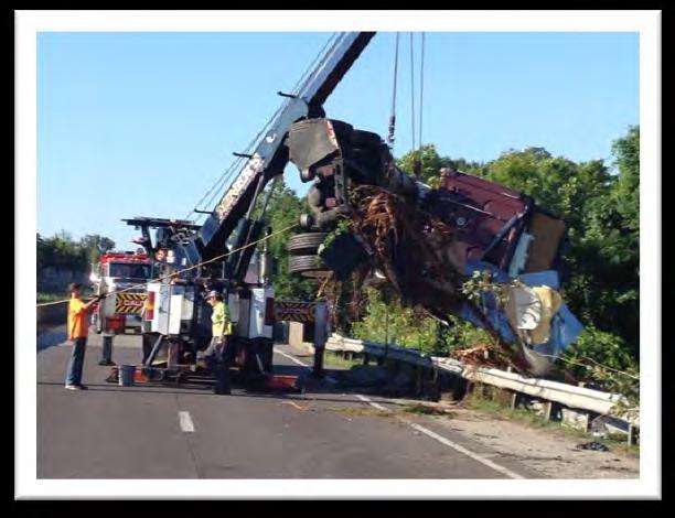
8 Incident Management Major Impact Traffic Incidents and Mitigation 7/10/2015 (Friday) Time: 3:14 am 7:42 am Location: St. Louis County Southbound I-270 at Dougherty Ferry Road Event: Multi-Vehicle Cars and Jackknifed Tractor Trailer Estimated Initial Impact: Rush Hour: 4 of 4 travel lanes affected equals (=) 100% Incident Detail: A car exited onto Dougherty Ferry and lost control. The vehicle slid down grass embankment traveled thru the guardrail and ended up in lane 1. The guardrail was knocked into the southbound lanes of I-270. A tractor trailer swerved to miss the guardrail and jackknifed. The tractor trailer went under the Dougherty Ferry overpass striking the rock wall and piers, causing debris to block the lanes. The truck split and could not be towed prior to start of rush hour. Action: Motorist Assist provided traffic control and the bridge was inspected for structural damage with none noted. Traffic initially diverted off at Dougherty Ferry with no queue. EOC and Motor Carriers were notified of the closure. Lanes were progressively opened for morning rush and the tractor trailer remained on shoulder until am rush was over. Event Duration: 4 hours 28 minutes Southbound I-270 at Daugherty Ferry Road Lane 1 Lane 2 Lane 3 Lane 4 Right Shoulder Closed Hours/Minutes 2:36 2:36 3:25 3:41 4:28 7/12/2015 (Sunday) Time: 11:29 pm 3:05 am ***Fatal*** Location: St. Louis County Westbound I-70 past Route 141 Event: Two-Vehicle Crash with 3 Fatalities Estimated Initial Impact: Non-Rush Hour: 3 of 4 travel lanes affected equals (=) 75% Incident Detail: A vehicle, while swerving to avoid a stalled vehicle, struck another and both vehicles overturned. Driver of first vehicle was fatally injured. The 2 passengers from second vehicle were ejected one off the bridge, resulting in two more fatalities. Closure resulted in a 1 mile queue for two hours and seven minutes. Action: Special Ops provided traffic control; MSHP Reconstruction and water rescue were called to scene. EOC, Communications, AE and Motor /Carriers were also notified. Event Duration: 3 hours 36 minutes Westbound I-70 past Route 141 Left Shoulder Lane 1 Lane 2 Lane 3 Lane 4 Right Shoulder Closed Hours/Minutes 0:00 0:00 3:29 3:36 3:36 3:36 8
 100% Incident Detail: A tractor trailer ran off the roadway and overturned, splitting open the trailer loaded with")
 resulting in a major disruption of mobility.")
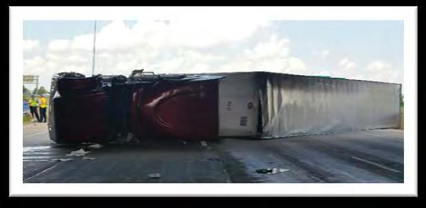
9 Incident Management Major Impact Traffic Incidents and Mitigation 7/15/2015 (Wednesday) Time: 5:08 am 3:52 pm Location: Jefferson County Southbound I-55 before McNutt Road Event: Overturned Tractor Trailer Estimated Initial Impact: Rush Hour: 2 of 2 travel lanes affected equals (=) 100% Incident Detail: A tractor trailer ran off the roadway and overturned, splitting open the trailer loaded with packaged cereal grain. Three separate tow vehicles were required to remove the tractor and trailer. Traffic was diverted from I-55 at Route Z to US 61 Southbound returning to I- 55 at MM 176. Traffic queued to Route M (4.5 miles) resulting in a major disruption of mobility. During the removal, the roadway was damaged and resulted in Maintenance replacing a large piece of pavement before the roadway could be totally open. Maintenance setup a lane drop in the right lane for repairs of the roadway and guardrail. Clean up of the spilled cereal grain occurred simultaneous. During the lane drop the queue was ¾ of a mile back to Route Z. Action: Motorist Assist and Maintenance responded for incident management, roadway repairs and traffic control. The on-call signal engineer was notified and made signal adjustments along the diversion route. MoDOT Communications, AE, EOC and Motor Carriers were notified of closure and detour route. Event Duration: 10 hours 43 minutes Southbound I-55 past McNutt Road Left Shoulder Lane 1 Lane 2 Right Shoulder Closed Hours/Minutes 5:19 5:19 10:43 10:43 9


10 Incident Management Major Impact Traffic Incidents and Mitigation 10
 100% Incident Detail A truck pulling a trailer full of go-carts and a car crashed. The trailer overturned closing both lanes.")
11 Incident Management Major Impact Traffic Incidents and Mitigation 7/27/2015 (Monday) Time: 4:23 am 8:04 am Location: Franklin County Westbound I-44 past Route 100 Event: Two-Vehicle Crash Estimated Initial Impact: Rush Hour: 2 of 2 travel lanes affected equals (=) 100% Incident Detail A truck pulling a trailer full of go-carts and a car crashed. The trailer overturned closing both lanes. Traffic was diverted to the right shoulder only. Action: Motorist Assist provided traffic control. Franklin County Sheriff responded to the incident but refused to let MA open the roadway until MSHP arrived and wrote the report. MSHP did not have a trooper on duty in the area and had to wait for someone to come on duty. The TMC messaged for motorists to seek an alternate route. Event Duration: 3 hours 39 minutes Westbound I-44 past Route 100 Left Shoulder Lane 1 Lane 2 Right Shoulder Closed Hours/Minutes 0:00 3:39 3:39 0:24 11
 100% Incident Detail:")
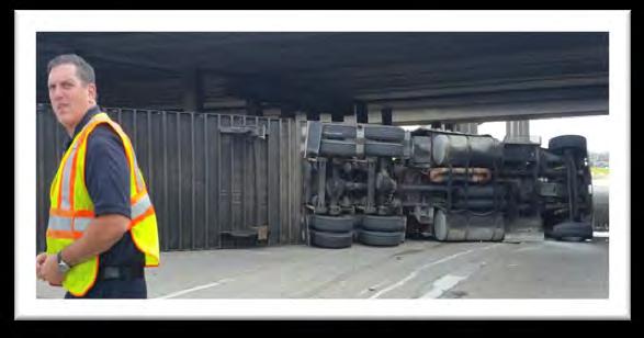
12 Incident Management Major Impact Traffic Incidents and Mitigation 8/6/2015 (Thursday) Time: 4:46 pm 10:40 pm ***Fatal*** Location: St. Charles County Westbound Route 370 past Truman Boulevard Event: MSHP Investigation of Hit and Run Estimated Initial Impact: Rush Hour: 3 of 3 travel lanes affected equals (=) 100% Incident Detail: Victim s vehicle broke down and he was struck while walking along roadside. This resulted in a total closure of Route 370 for an investigation. Action: Motorist Assist responded for traffic control, MSHP performed investigation and reconstruction. EOC, Motor Carriers and MoDOT Communications were notified of closures. TMC message for motorists to use an alternate route. Westbound Route 370 past Truman Boulevard Left Shoulder Lane 1 Lane 2 Right Shoulder Closed Hours/Minutes 5:54 5:54 5:54 5:54 8/10/2015 (Monday) Time: 5:18 pm 8:06 pm Location: St. Louis County Eastbound/Westbound I-70 before/past Route 141 Event: Civil Unrest Estimated Initial Impact: Rush Hour: 5 of 5 travel lanes affected equals (=) 100% Incident Detail: Protesters blocked all lanes of traffic in both directions at the Blanchette Bridge. They set up barricades then stood in the middle of the highway bringing traffic to a complete stop. Closure resulted in a 2 mile queue. Westbound traffic was diverted to Route 141. Eastbound traffic was asked to seek an alternate route. Action: Motorist Assist provided traffic control and the TMC messaged for the closure. Emergency responders from MSHP, Bridgeton and Maryland Heights Police arrived with buses and police vehicles to apprehend 63 protesters for shutting down the Interstate. Lanes were progressively opened to move traffic as protesters were removed from the roadway Event Duration: 2 hours 48 minutes 12


13 Incident Management Major Impact Traffic Incidents and Mitigation Eastbound/I-70 before Route 141 Left Shoulder Lane 1 Lane 2 Lane 3 Lane 4 Lane 5 Right Shoulder Closed Hours/Minutes 2:48 2:29 0:26 0:26 0:26 0:26 2:48 Westbound/I-70 past Route 141 Left Shoulder Lane 1 Lane 2 Lane 3 Lane 4 Lane 5 Right Shoulder Closed Hours/Minutes 0:53 0:53 0:53 0:53 0:53 2:48 2:48 13
14 Incident Management Major Impact Traffic Incidents and Mitigation 8/12/2015 (Wednesday) Time: 11:28 pm 2:51 am *** Fatal*** Location: St. Louis County Southbound I-270 past Gravois Road Event: Multi-vehicle Crash Estimated Initial Impact: Non-Rush Hour: 4 of 4 travel lanes affected equals (=) 100% Incident Detail: Multi-vehicle crash involving 4 cars and a motorcycle. Crash resulted in a full closure for crash reconstruction. Traffic queued to Route 30 and was diverted off I-270 at Route 30 to US 67 and back on I-270 at Route 21. Action: Motorist Assist provided traffic control and the TMC messaged for closure. Fenton Police and Fire, Sunset Hills Police, Medical Examiner and MSHP responded. After the reconstruction took place MSHP lost their reconstruction camera on scene and asked to reclose the interstate to find it. EOC and Motor Carriers were notified of closure. Event Duration: 3 hours 23 minutes Southbound I-270 past Gravois Road Lane 1 Lane 2 Lane 3 Lane 4 Right Shoulder Closed Hours/Minutes 3:20 3:20 3:20 3:20 3:23 14
 100% Incident Detail: A tractor trailer carrying")
15 Incident Management Major Impact Traffic Incidents and Mitigation 8/17/2015 (Monday) Time: 2:40 pm 7:26 pm Location: St. Louis County Southbound I-55 at I-255 Event: Overturned Tractor Trailer Estimated Initial Impact: Rush Hour: 5 of 5 travel lanes affected equals (=) 100% Incident Detail: A tractor trailer carrying 40,000 pounds of zinc overturned, closing all southbound lanes of I-55. Southbound traffic queued to Reavis Barracks Road on I-55 and Westbound on I-255 to Telegraph, causing travel southbound on I-55 and westbound/ northbound I-255/I-270 slow throughout rush period. Action: Motorist Assist provided traffic control and helped position the load to upright the vehicle. TMC messaged for the closure. EOC, Motor Carriers, Communications and the Area Engineer were all notified. Event Duration: 4 hours 46 minutes Southbound I-55 at I-255 Left Shoulder Lane 1 Lane 2 Lane 3 Lane 4 Lane 5 Right Shoulder Closed Hours/Minutes 4:46 4:17 4:16 4:07 4:07 4:07 4:07 15


16 Incident Management Major Impact Traffic Incidents and Mitigation 16
17 Freeway Management (This page is intentionally left blank) 17
18 Freeway Management B D E F C A AM Peak Mobility Snapshot July 2015 B High Mobility D E F Medium Mobility A C Low Mobility *All weekdays are included in speed index 18


19 Freeway Management B D E C F A AM Peak Mobility Snaphot August 2015 High Mobility A B E Medium Mobility C D F Low Mobility *All weekdays are included in speed index 19


20 Freeway Management 12 Bowles Ave B 9 12 I


21 Freeway Management C 9 12 Big Bend 3 6 D 21
22 Freeway Management E F 22
23 Freeway Management (This page is intentionally left blank) 23


24 Freeway Management A D E B C F PM Peak Snapshot July 2015 High Mobility Medium Mobility A B Low Mobility *All weekdays are included in speed index 24

25 Freeway Management A D F E B C G PM Peak Snapshot August 2015 F G High Mobility C Medium Mobility A B D E Low Mobility *All weekdays are included in speed index 25


26 Freeway Management 12 W/O US Market Street
27 Freeway Management D E F 27

28 Freeway Management G 28


29 Freeway Management NEW for 2015! The focus area for calculating the average 24 hour volumes was revisited and consolidated to the more urban interstates of the St. Louis District. For example, data is generated from detectors on I-44 east of MO 141 (previously included all available in the District). All baseline data for 2014 was recalculated with the revised detectors on routes as shown above. 29

30 Arterial Management 30

31 Arterial Management 31

32 Arterial Management 32
33 Arterial Management 33
34 Data Key Work Zones Whenever additional travel time is reported, this additional time shall be evaluated using this chart and adequate mitigation measures should begin within the parameters of this chart. TMC and field personnel are partners in the mitigation of traffic and notification of additional travel times should trigger the appropriate response from both parties. Chart is designed to be an additional travel time reference to establish parameters for gauging the travel impact through work zones and to provide guidance for taking mitigation actions. Travel times can be collected or reported via Blue Toad technology, field personnel, call reports, ITS, TMC cameras, etc. Major and Moderate impacts trigger an IAR (Immediate Action Required) event. IAR means work zone user and TMC partner together to take immediate actions to reduce or eliminate distress. During an IAR event mitigation procedures can range from increased driver notification up to and including removal of work zone. Additional mitigation procedures may require involvement of administration through use of the work zone resolution ladder. Level of Impact Major (Red) IAR Event SEVERE DISTRESS PRESENT Return of roadway to free flow traffic is Priority #1 Moderate (Yellow) IAR Event CAUTIONARY STAGE: Action required by Field/ TMC to prevent escalation to a major event Additional Travel Time Expected 15 minutes or above TMC and field personnel take all steps possible up to and including removal of lane closure to achieve free flow threshold minutes TMC increases driver messaging. Field begins efforts to restore free flow traffic Mitigation Actions Immediate Action Required Supervisory mitigation assistance is required using the St. Louis District Work Zone Resolution Ladder as a tool to restore free flow traffic threshold TMC and field shall reach a consensus on mitigation success within 15 minutes or less. If a consensus cannot be reached, mitigation should be scaled upwards in accordance with the St. Louis District Work Zone Resolution Ladder 34


35 Data Key Incident Levels Major Impact Traffic Incident Road closure > 2 hours Major traffic incidents are typically traffic incidents involving hazardous materials, fatal traffic crashes involving numerous vehicles, and other natural or man-made disasters. These traffic incidents typically involve closing all or part of a roadway facility for a period exceeding 2 hours. Moderate Impact Traffic Incident Blocked travel lanes/closure 30 min 2 hours Moderate traffic impact incidents typically affect travel lanes for a time period of 30 minutes to 2 hours, and usually require traffic control on the scene to divert road users past the blockage. Full roadway closures might be needed for short periods during traffic incident clearance to allow traffic incident responders to accomplish their tasks. Minor Impact Traffic Incident Lane closures < 30 minutes Minor traffic incidents are typically disabled vehicles and minor crashes that result in lane closures of less than 30 minutes. On-scene responders are typically law enforcement and towing companies, and occasionally highway agency service patrol vehicles. Worst Time to Travel Clocks - The clocks found on the speed charts depict the progression of travel speeds during the commute peak period at the worst congestion location along the route. - For example, the clock on the left depicts conditions worsening at a particular location beginning at 6:30 a.m. with the slowest speeds between 7 a.m. and 8:15 a.m. Conditions improved at 8:45 a.m. Definitions ACTRA Traffic signal management software program Alert message sent regarding an incident or event on the roadway Arterial Missouri State Highway Numbered Routes, not fully access controlled Arterial Device ITS equipment located along MoDOT arterials DMS - Dynamic Message Signs along highway displaying incident and travel time information Defined Sensor A single sensor with an individual ID focused on a particular roadway; defined sensors may be located at one physical sensor location Driver messaging Messages placed on DMS boards to alert drivers of incidents ahead of their direction of travel EOC Emergency Operations Center operated by MoDOT in Jefferson City ER MoDOT s Emergency Response units that provide emergency assistance during nights and weekends typically not covered by Motorist Assist units multiple 35
36 Data Key Freeway Device ITS device located along a MoDOT freeway, such as interstates and other fully access controlled highways Gatewayguide.com Gateway Guide s website for local St. Louis area traffic information GuidePost Area of report highlighting important mobility topics for the month IDOT - Illinois Department of Transportation KC Scout Gateway Guide s counterpart for the greater Kansas City Metropolitan area, a collaboration involving both MoDOT and the Kansas DOT Mobility Ease of movement over roadway, through system, and or work zone MRB Mississippi River Bridge under construction north of downtown St. Louis Observed Work zone Work zone tracked by traffic cameras at the TMC Peak Average Daily speed sensor readings over an entire weekday average commute period averaged for an entire month PSB - Poplar Street Bridge Regional Mobility Overview Map depicting congestion areas based on speed index ratings derived from speed sensor readings Speed Index a ratio of the speed at which vehicles travel during a period to the speed at free-flow conditions Stats to Watch Area of report highlighting interesting trends for the report month, or data to be closely followed STLtraffic group consisting of Gateway Guide personnel and Gateway Guide s media partners, messages sent to the group are also posted on Twitter TMC Traffic Management Center (also referred to as Gateway Guide) TMC Alert alert sent to an internal group of Gateway Guide personnel TMS Traveler Map System is MoDOT s internal software for entering work zones and road conditions to populate the Traveler Information Map at Travel Time Index - A ratio of the actual time to travel a corridor compared to travel time at posted speed limit without stops used Visibility- Concerning placement of traffic signs, signals, devices, barricades and warning lights for safety within work zone or construction area to help motorist and workers move within a work zone safely; Clearly visible and legible, distinguishable to approaching traffic during day and night, aligned with road user s line of vision, and positioned as to not obstruct other applicable traffic control devices. Must meet MUTCD standards for condition and must be covered, turned or properly stowed when not in use. Zoning In section of report highlighting important construction topics for the report month 36
37 Data Key I-70 Mile Markers ST. CHARLES COUNTY 5TH ST SOUTH (ST. CHARLES) 229A 5TH ST NORTH (ST. CHARLES) 229B ST. LOUIS COUNTY BLANCHETTE BRIDGE 230 EARTH CITY EXPRESSWAY SOUTH 231A EARTH CITY EXPRESSWAY NORTH 231B I MCKELVEY RD OVERPASS (BRIDGETON) 233 RTE 180/ST. CHARLES ROCK RD (BRIDGETON 234 US 67 SOUTH (BRIDGETON) US 67 NORTH (BRIDGETON) CYPRESS RD (BRIDGETON) AIRFLIGHT (ST. ANN) MCDONNELL OVERPASS (BERKELEY) LAMBERT AIRPORT (BERKELEY) I-170 NORTH (BERKELEY) I-170 SOUTH (BERKELEY) NORTH HANLEY (BERKELEY) RTE N/FLORISSANT RD (COOL VALLEY) BERMUDA DR (NORMANDY) RTE U/LUCAS AND HUNT RD JENNINGS STATION RD (PINE LAWN) ST. LOUIS CITY GOODFELLOW (ST. LOUIS) RIVERVIEW/BIRCHER (ST. LOUIS) UNION (ST. LOUIS) KINGSHIGHWAY (ST. LOUIS) SHREVE (ST. LOUIS) WEST FLORISSANT AVE (ST LOUIS) NORTH BROADWAY (ST. LOUIS) ADELAIDE (ST LOUIS) GRAND (ST. LOUIS) SALISBURY (ST LOUIS) BRANCH (ST LOUIS) MADISON (ST LOUIS) PINE ST OVERPASS (ST LOUIS) CHESTNUT ST OVERPASS (ST LOUIS) MARKET ST OVERPASS (ST. LOUIS) WALNUT ST OVERPASS (ST LOUIS) 235A 235B 235C A 238B 238C A 240B 241B 242C 243A 243B 244A 244B 245A 245B 246A 246B A 248B 249A I-70 DISTRICT 6 WESTBOUND I-70 DISTRICT 6 EASTBOUND 229A 229B A 231B A 235B 235C A 238B 238C A 240B 241B 242C 243A 243B 244A 244B 245A 245B 246A 246B A 248B 249A ST. CHARLES COUNTY 5TH ST SOUTH (ST. CHARLES) 5TH ST NORTH (ST. CHARLES) ST. LOUIS COUNTY BLANCHETTE BRIDGE EARTH CITY EXPRESSWAY SOUTH EARTH CITY EXPRESSWAY NORTH I-270 MCKELVEY RD OVERPASS (BRIDGETON) RTE 180/ST. CHARLES ROCK RD (BRIDGETON US 67 SOUTH (BRIDGETON) US 67 NORTH (BRIDGETON) CYPRESS RD (BRIDGETON) AIRFLIGHT (ST. ANN) MCDONNELL OVERPASS (BERKELEY) LAMBERT AIRPORT (BERKELEY) I-170 NORTH (BERKELEY) I-170 SOUTH (BERKELEY) NORTH HANLEY (BERKELEY) RTE N/FLORISSANT RD (COOL VALLEY) BERMUDA DR (NORMANDY) RTE U/LUCAS AND HUNT RD JENNINGS STATION RD (PINE LAWN) ST. LOUIS CITY GOODFELLOW (ST. LOUIS) RIVERVIEW/BIRCHER (ST. LOUIS) UNION (ST. LOUIS) KINGSHIGHWAY (ST. LOUIS) SHREVE (ST. LOUIS) WEST FLORISSANT AVE (ST LOUIS) NORTH BROADWAY (ST. LOUIS) ADELAIDE (ST LOUIS) GRAND (ST. LOUIS) SALISBURY (ST LOUIS) BRANCH (ST LOUIS) MADISON (ST LOUIS) PINE ST OVERPASS (ST LOUIS) CHESTNUT ST OVERPASS (ST LOUIS) MARKET ST OVERPASS (ST. LOUIS) WALNUT ST OVERPASS (ST LOUIS) 37
38 Data Key I-70 St. Charles County Mile Markers RTE A (WENTZVILLE) RTE A (WENTZVILLE) LAKE ST. LOUIS BLVD (LAKE ST. LOUIS) LAKE ST. LOUIS BLVD (LAKE ST. LOUIS) BRYAN RD (O'FALLON) BRYAN RD (O'FALLON) RTE K/RTE M (O'FALLON) T.R. HUGHES BLVD (O'FALLON) RTE 79 (ST. PETERS/O'FALLON) RTE C/MID RIVERS MALL DR (ST. PETERS) SPENCER RD OVERPASS (ST. PETERS) RTE 370 (ST. PETERS) CAVE SPRINGS (ST. CHARLES) ZUMBEHL RD (ST. CHARLES) HAWK'S NEST OVERPASS (ST. CHARLES) RTE 94 (ST. CHARLES) I-70 DISTRICT 6 EASTBOUND I-70 DISTRICT 6 WESTBOUND RTE K/RTE M (O'FALLON) T.R. HUGHES BLVD (O'FALLON) RTE 79 (ST. PETERS/O'FALLON) RTE C/MID RIVERS MALL DR (ST. PETERS) SPENCER RD OVERPASS (ST. PETERS) RTE 370 (ST. PETERS) CAVE SPRINGS (ST. CHARLES) ZUMBEHL RD (ST. CHARLES) HAWK'S NEST OVERPASS (ST. CHARLES) RTE 94 (ST. CHARLES) 5TH ST SOUTH (ST. CHARLES) 229A 229A 5TH ST SOUTH (ST. CHARLES) 5TH ST NORTH (ST. CHARLES) 229B 229B 5TH ST NORTH (ST. CHARLES) 38
39 Data Key I-270 Mile Markers 3 2 1C 1B C A 25B A 31B KOCH RD SR 231 (TELEGRAPH RD) US61-67 I-55 NORTH I-55 SOUTH SR 21 (TESSON FERRY RD.) SR 30 (GRAVOIS RD.) I-44 EAST/SR 366 (WATSON RD.) I-44 WEST DOUGHERTY FERRY RD. SR 100 (MANCHESTER RD.) I-64 EAST/WEST/US NORTH/SOUTH SR AB (LADUE RD) SR 340 (OLIVE BLVD) SR D (PAGE AVE.) EAST SR 364 WEST DORSETT RD I-70 WEST/EAST SR 180 (ST. CHARLES ROCK RD) MISSOURI BOTTOM RD/370 WEST MCDONNELL BLVD US 67 SOUTH US 67 NORTH HANLEY/GRAHAM RD. I-170 SOUTH NEW FLORISSANT RD WASHINGTON/ELIZABETH RD. WEST FLORISSANT RD SR AC HALLS FERRY RD SR 367 SOUTH SR 367 NORTH BELLEFONTAINE RD LILAC AVE. RIVERVIEW DR. I-255 WESTBOUND --- > I-270 DISTRICT 6 CLOCKWISE FROM I-55 TO RIVERVIEW DR. --- > I-255 EASTBOUND <--- I-270 DISTRICT 6 COUNTER CLOCKWISE FROM RIVERVIEW DR. TO I-55 <--- KOCH RD SR 231 (TELEGRAPH RD) US61-67 I-55 NORTH I-55 SOUTH SR 21 (TESSON FERRY RD.) SR 30 (GRAVOIS RD.) I-44 EAST I-44 WEST BIG BEND RD. DOUGHERTY FERRY RD. SR 100 (MANCHESTER RD.) I-64 EAST/WEST/US NORTH/SOUTH SR AB (LADUE RD) SR 340 (OLIVE BLVD) SR D (PAGE AVE.) EAST SR 364 WEST DORSETT RD I-70 WEST I-70 EAST SR 180 (ST. CHARLES ROCK RD) SR 370 WEST MCDONNELL BLVD US 67 NORTH US 67 SOUTH I-170 SOUTH (EXIT LEFT) HANLEY/GRAHAM NEW FLORISSANT RD ELIZABETH/WASHINGTON WEST FLORISSANT RD SR AC NEW HALLS FERRY RD NEW HALLS FERRY RD. SR 367 SOUTH SR 367 NORTH BELLEFONTAINE RD LILAC AVE. RIVERVIEW DR B 1B 1A A/B A 16B 17 20B 20A 20C 22D 23 25A 25B 26A 26B A 31A 31B
40 Data Key I-64 Mile Markers I-70 WEST EXIT RIGHT/EAST EXIT LEFT 1 1A I-70 WEST 1B I-70 EAST PROSPECT RD 1C 1C PROSPECT RD LAKE ST. LOUIS BLVD 2 2 LAKE ST. LOUIS BLVD SR N 4 4 MO N SR DD/WINGHAVEN 6 6 MO DD/Winghaven SR K/SR MO K 10 MO 94 MISSOURI RESEARCH PARK/TECHNOLOGY DR RESEARCH PARK CRL DANIEL BOONE BRIDGE DANIEL BOONE BRIDGE CHESTERFIELD AIRPORT RD SPIRIT OF ST LOUIS BLVD 16 LONG RD BOONE S CROSSING BOONE S CROSSING CHESTERFIELD PKWY 19A 19A CHESTERFIELD PKWY SR 340 (OLIVE/CLARKSON 19B 19B MO 340 (OLIVE/CLARKSON) 20 CHESTERFIELD PKWY TIMBERLAKE MANOR PKWY TIMBERLAKE MANOR PKWY SR MO 141 (WOODS MILL RD) MASON RD I-270 SOUTH I-270 NORTH SR JJ (BALLAS RD) SPOEDE RD US A 25B A I-64 DISTRICT 6 WESTBOUND I-64 DISTRICT 6 EASTBOUND A 25B A MARYVILLE CENTRE DR MASON RD I-270 SOUTH I-270 NORTH MO JJ (BALLAS RD) SPOEDE RD US B CLAYTON RD MCKNIGHT RD MCKNIGHT RD BRENTWOOD/HANLEY RD 31B 31A I-170 NORTH I-170 NORTH 31A 31B HANLEY RD/BRENTWOOD BLVD BELLEVUE AVE 33B BIG BEND 33A 33A BIG BEND BLVD MCCAUSLAND 33C ST. LOUIS CITY ST. LOUIS CITY 33C MCCAUSLAND AVE HAMPTON AVE/OAKLAND AVE 34B 34A CLAYTON RD/SKINKER BLVD 34B HAMPTON AVE KINGSHIGHWAY 36A 36A KINGSHIGHWAY VANDEVENTER AVE 36C 36B BOYLE MARKET ST/BERNARD ST 37A GRAND AVE 37B JEFFERSON AVE 38A 38A FOREST PARK AVE/GRAND BLVD CHESTNUT AT 20TH ST 38B 38B MARKET ST AT 3000 WEST 14TH ST 39B 39A MARKET ST AT 21ST 11TH ST EXIT LEFT 39C 40A STADIUM/9TH ST/ TUCKER BLVD BROADWAY/7TH ST (LAST MISSOURI EXIT) 40B 40C I-44 WB/I-55 SB/ I-70 WB 40
41 Data Key I-55 Mile Markers JEFFERSON COUNTY JEFFERSON COUNTY RTE M RTE M MAIN ST(IMPERIAL) MAIN ST(IMPERIAL) RICHARDSON RD (ARNOLD) RICHARDSON RD (ARNOLD) RTE 141 (ARNOLD) RTE 141 (ARNOLD) ST. LOUIS COUNTY ST. LOUIS COUNTY MERAMEC BOTTOM RD MERAMEC BOTTOM RD BUTLER HILL RD 195 I-255 EAST 196A I-270 NORTH 196B US67/LINDBERGH 197 REAVIS BARRACKS RD 199 UNION RD 200 BAYLESS 201A WEBER RD 201B ST. LOUIS CITY GERMANIA (ST. LOUIS) 202B LOUGHBOROUGH AVE (ST. LOUIS 202C I-55 DISTRICT 6 NORTHBOUND I-55 DISTRICT 6 SOUTHBOUND A 196B A 201B 202B 202C BUTLER HILL RD I-255 EAST I-270 NORTH US67/LINDBERGH REAVIS BARRACKS RD UNION RD BAYLESS WEBER RD ST. LOUIS CITY GERMANIA (ST. LOUIS) LOUGHBOROUGH AVE (ST. LOUIS BATES (ST. LOUIS) BATES (ST. LOUIS) BROADWAY (ST. LOUIS) BROADWAY (ST. LOUIS) GASCONADE (ST. LOUIS) GASCONADE (ST. LOUIS) ARSENAL (ST. LOUIS) 206C 206C ARSENAL (ST. LOUIS) SIDNEY OVERPASS SIDNEY OVERPASS GRAVOIS AVE OVERPASS GRAVOIS AVE OVERPASS I-44 WEST (ST. LOUIS) I-44 WEST (ST. LOUIS) 7TH ST/PARK AVE (ST. LOUIS) TH ST/PARK AVE (ST. LOUIS) 41
42 Data Key I-44 Mile Markers FRANKLIN COUNTY FRANKLIN COUNTY PACIFIC PACIFIC ST. LOUIS COUNTY 261 ALLENTON/SIX FLAGS ALLENTON/SIX FLAGS 261 ST. LOUIS COUNTY RTE 109/RTE W RTE 109/RTE W WILLIAMS RD 265 LEWIS RD LEWIS RD 269 ANTIRE RTE RTE 141 BOWLES BOWLES MRAZ 274 I-270 NORTH I-270 SOUTH RTE 366/WATSON US 67/LINDBERGH BIG BEND ELM LACLEDE STATION 276B 276A 277A 277B I-44 DISTRICT 6 WESTBOUND I-44 DISTRICT 6 EASTBOUND B 276A 277B SOCCER PARK I-270 NORTH I-270 SOUTH US 67/LINDBERGH BIG BEND BERRY ELM ST. LOUIS CITY 283 SHREWSBURY JAMIESON 284A ST. LOUIS CITY 284B ARSENAL 285 SOUTHWEST HAMPTON 286 KINGSHIGHWAY KINGSHIGHWAY GRAND AVE GRAND AVE JEFFERSON AVE JEFFERSON AVE I-55 SOUTH 290A 18TH ST 290B 290C 12TH ST./GRAVOIS 42
43 Data Key I-170 Mile Markers I-64 WEST/US A I-64 EAST/US B 1C GALLERIA PARKWAY BRENTWOOD BLVD 1D FOREST PARK PARKWAY 1E 1E FOREST PARK PARKWAY LADUE RD 1F 1F LADUE RD DELMAR EAST/3B WEST SR 340 (OLIVE BLVD) SRD/SR 364 (PAGE AVE) SR 180 (ST. CHARLES ROCK RD) SR 115 (NATURAL BRIDGE RD) I-70 EAST (EXIT LEFT) I-70 WEST (EXIT RIGHT) SCUDDER 2 3A A 7B 8 I-170 DISTRICT 6 SOUTHBOUND I-170 DISTRICT 6 NORTHBOUND A 7B 7C 8 DELMAR SR 340 (OLIVE BLVD) SR D/SR 364 (PAGE AVE) SR 180 (ST. CHARLES ROCK RD) SR 115 (NATURAL BRIDGE RD) I-70 EAST (EXIT RIGHT) I-70 WEST (EXIT LEFT) LAMBERT ST. LOUIS AIRPORT SCUDDEN/N. HANLEY RD AIRPORT RD 9A 9A AIRPORT 9B BOEING (EXIT LEFT) 9C N. HANLEY RD 10A I-270 WEST (EXIT RIGHT) 10B I-270 EAST (EXIT LEFT) SR 364 Mile Markers 11B HARVESTER RD SR94 EAST/ST. CHARLES ARENA PKWY/UPPER BOTTOM RD MARYLAND HEIGHTS EXPRESSWAY BENNINGTON PL I-270 SOUTH A SR 364 EASTBOUND SR 364 WESTBOUND HERITAGE CROSSING/JUNGS STATION RD SR 94 EAST/MUEGGE RD UPPER BOTTOM/ARENA MARYLAND HEIGHTS EXPRESSWAY BENNINGTON PL I-270 NORTH 22B 43
44 Data Key SR 370 Mile Markers 1A I-70 WESTBOUND 1B I-70 EASTBOUND 1C SPENCER RD TRUMAN/CAVE SPRINGS RD 2 2 TRUMAN/CAVE SPRINGS RD ELM/NEW TOWN BLVD N 3RD ST/SR 94 DISCOVERY BRIDGE ST. CHAS CO/ ST. LOUIS CO EARTH CITY EXPRESSWAY ST. LOUIS MILLS BLVD SR 370 EASTBOUND SR 370 WESTBOUND ELM/NEW TOWN BLVD N 3RD ST/SR 94 DISCOVERY BRIDGE ST. LOUIS CO/ ST. CHAS CO EARTH CITY EXPRESSWAY ST. LOUIS MILLS BLVD MISSOURI BOTTOM RD 12 I-270 WEST BOUND 12 I-270 EAST BOUND 12 SR 21 Mile Markers RT B RT B RT BB RT BB STADIUM DR UNDERPASS STADIUM DR UNDERPASS RTE A RTE A SAND CREEK SAND CREEK HAYDEN RD HAYDEN RD GLADE CHAPEL RD OVERPASS GLADE CHAPEL RD OVERPASS OLD HWY 21 (GOLDMAN) KLABLE RD OVERPASS SCHENK RD OVERPASS HEADS CREEK RT MM W. FOUR RIDGE RD OVERPASS SR 21 NORTHBOUND SR 21 SOUTHBOUND OLD HWY 21 (GOLDMAN) KLABLE RD OVERPASS SCHENK RD OVERPASS HEADS CREEK RT MM W. FOUR RIDGE RD OVERPASS OLD HWY 21 (SHADY VALLEY) OLD HWY 21 (SHADY VALLEY) OLD HWY 21 UNDERPASS OLD HWY 21 UNDERPASS WEST ROCK CREEK RD OVERPASS WEST ROCK CREEK RD OVERPASS OLD HWY 21 OVERPASS OLD HWY 21 OVERPASS LONDELL RD LONDELL RD OLD HWY OLD HWY 21 SR SR
St. Louis District Mobility
 St. Louis District Mobility January 2015 GuidePost Freeway mobility improved with 11% less volume compared to December 2014 Arterial Peak period Travel remained consistent with slowing along routes at
St. Louis District Mobility
 St. Louis District Mobility August 2014 GuidePost Freeway mobility slightly declined throughout the region in both AM and PM peaks Arterial travel declined in both the AM and PM peaks low mobility along
St. Louis District Mobility
 St. Louis District Mobility December 2014 GuidePost Freeway mobility declined with heavy volumes slowing travel on stretches of I-64 / I-70 / I-270 December Freeway volumes increased by 4.7% from 2013
AUGUST 3, 2009 METRO SERVICE RESTORATION PLAN
 AUGUST 3, 2009 METRO SERVICE RESTORATION PLAN BACKGROUND The St. Louis region has long been without a permanent, stable and sufficient source of transit funding and this year faced a large budget deficit
THE RETINA INSTITUTE Post-Operative Appointment
 THE RETIA ISTITUTE Post-Operative Appointment Date: Time: Location: Doctor: On the attached sheets you will find directions to the office where you will see a doctor for your appointment. There is a map
THE RETINA INSTITUTE Post-Operative Appointment
 Post-Operative Appointment Date: Time: Location: Doctor: On the attached sheets you will find directions to the office where you will see a doctor for your appointment. There is a map for each possible
CONTACT: Nichole Lawrence CELL: FOR IMMEDIATE RELEASE Wednesday March 28, 2018
 FOR IMMEDIATE RELEASE Wednesday March 28, 2018 CONTACT: Nichole Lawrence CELL: 731-225-6041 West Tennessee Construction March 28-April 4, 2018 Per TDOT Specifications, there will be no temporary lane closures
B. Congestion Trends. Congestion Trends
 B. Congestion Trends Congestion Trends There are two types of congestion that impact mobility: recurring and non-recurring congestion. Recurring congestion is related to segments of roadway that are over
I-270 Bridge Renovation at New Florissant Road
 I-270 Bridge Renovation at New Florissant Road What is the problem? The I-270 bridge over New Florissant Road in north St. Louis County is more than 50 years old. It is classified as structurally deficient
DIRECTIONS TO SITES Christ Church 7126 Bruno Maplewood, MO Christ the King Old Halls Ferry Road Black Jack, MO 63033
 DIRECTIONS TO SITES Christ Church (12.92 miles from Fern, 25.84 round trip) Bus #16- Bruno and Bellevue 7126 Bruno Maplewood, MO 63143 Church is on the corner of Bruno and Bellevue. From Highway 40: Exit
Event Chronology. [From Event ID]: , [Event Status]: Any Valid. Manatee I-75 NB Location: MILE MARKER 226. True. False.
![Event Chronology. [From Event ID]: , [Event Status]: Any Valid. Manatee I-75 NB Location: MILE MARKER 226. True. False.](/thumbs/78/78776017.jpg "Event Chronology. [From Event ID]: , [Event Status]: Any Valid. Manatee I-75 NB Location: MILE MARKER 226. True. False.") Created On: Center: Filter Parameters Selected: Period: Event(s) Found: Event ID Range: 07/07/2016 08:12:37 District 1 [From Event ID]: 319444, [Event Status]: Any Valid 07/06/2016 1 319,444 Event #: 319444
Created On: Center: Filter Parameters Selected: Period: Event(s) Found: Event ID Range: 07/07/2016 08:12:37 District 1 [From Event ID]: 319444, [Event Status]: Any Valid 07/06/2016 1 319,444 Event #: 319444
Exit 136 (Centreport Parkway/Stafford County) to Exit 130 (Route 3/Fredericksburg)
 to Exit 130 (Route 3/Fredericksburg)") RELEASE: IMMEDIATE Feb. 22, 2019 CONTACT: Darragh Frye 540-907-8409 (mobile) VDOT HOT SPOTS IN THE FREDERICKSBURG DISTRICT Feb. 24 March 2, 2019 All work is scheduled weather permitting. Real-time information
RELEASE: IMMEDIATE Feb. 22, 2019 CONTACT: Darragh Frye 540-907-8409 (mobile) VDOT HOT SPOTS IN THE FREDERICKSBURG DISTRICT Feb. 24 March 2, 2019 All work is scheduled weather permitting. Real-time information
First Coast TIM Meeting Tuesday, July 19, 2016 Meeting Minutes
 First Coast TIM Meeting Tuesday, July 19, 2016 Meeting Minutes The list of attendees, agenda, and meeting handouts are attached to these meeting minutes. Introductions Josh Reichert opened and welcomed
DISTRICT EXPRESS LANES ANNUAL REPORT FISCAL YEAR 2017 JULY 1, 2016 JUNE 30, FloridaExpressLanes.com
 DISTRICT EXPRESS LANES ANNUAL REPORT FISCAL YEAR 2017 JULY 1, 2016 JUNE 30, 2017 FloridaExpressLanes.com This page intentionally left blank. TABLE OF CONTENTS List of Figures... ii List of Tables.... ii
Exit 148 (Quantico) to Exit 133 (Route 17/Fredericksburg)
 to Exit 133 (Route 17/Fredericksburg)") RELEASE: IMMEDIATE March 1, 2019 CONTACT: Darragh Frye 540-907-8409 (mobile) VDOT HOT SPOTS IN THE FREDERICKSBURG DISTRICT March 3 March 9, 2019 All work is scheduled weather permitting. Real-time information
RELEASE: IMMEDIATE March 1, 2019 CONTACT: Darragh Frye 540-907-8409 (mobile) VDOT HOT SPOTS IN THE FREDERICKSBURG DISTRICT March 3 March 9, 2019 All work is scheduled weather permitting. Real-time information
MISSOURI WALGREENS STORES
 1 Grasso Plz. Afton MO 63123-3107 440 N. Andover Rd. Andover KS 67002-9508 3937 Vogel Rd. Arnold MO 63010-3798 776 Jeffco Blvd. Arnold MO 63010-1415 1391 Big Bend Rd. Ballwin MO 63021-7616 1205 Sulphur
Weekly East Tennessee Construction Report for May 31-June 6, 2018
 Weekly East Tennessee Construction Report for May 31-June 6, 2018 Thursday, May 31, 2018 01:30pm ANDERSON COUNTY, SR 62 between Union Valley Road and SR 162: Motorists should be alert for possible lane
VDOT HOT SPOTS IN THE FREDERICKSBURG DISTRICT
 RELEASE: IMMEDIATE Aug. 10, 2018 CONTACT: Darragh Frye 540 899 4119 (office) 540 907 8409 (cell) Darragh.Frye@VDOT.Virginia.gov VDOT HOT SPOTS IN THE FREDERICKSBURG DISTRICT August 12 August 18, 2018 All
FINAL TERMINAL TRAFFIC MONITORING STUDY
 FINAL TERMINAL 91 216 TRAFFIC MONITORING STUDY Prepared for: Port of Seattle February 15, 217 Prepared by: 12131 113 th Avenue NE, Suite 23 Kirkland, WA 9834-712 Phone: 425-821-3665 www.transpogroup.com
A VISION FOR I-95. January 12, Delaware Department of Transportation
 A VISION FOR I-95 January 12, 2011 Delaware Department of Transportation The East Coast s Main Street Along with SR 1, the most significant highway in Delaware 29 miles to I ".', 2 Sponsoring / Cooperating
Route 141 and I-44 Design-Build Project Community Involvement Group. March 21, 2016
 Route 141 and I-44 Design-Build Project Community Involvement Group March 21, 2016 Purpose of CIG 1. Share information with major stakeholders 2. Keep stakeholders informed of the process 3. Reduce uncertainty
BALLAS METROBUS CENTER
 BALLAS METROBUS CETER Effective Date: March 14, 2016 I-64 Ramp Ballas Rd SPEED LIMIT 10 Call A Ride Ballas Transfer Center 64 64 Catalan Loop Effective Date: August 30, 2010 W E S Broadway 48 S. Lindbergh
Exit 148 (Quantico) to Exit 133 (Route 17/Falmouth)
 to Exit 133 (Route 17/Falmouth)") RELEASE: IMMEDIATE March 8, 2019 CONTACT: Tina.Bundy 540-907-8325 (mobile) VDOT HOT SPOTS IN THE FREDERICKSBURG DISTRICT March 10 March 16, 2019 All work is scheduled weather permitting. Real-time information
RELEASE: IMMEDIATE March 8, 2019 CONTACT: Tina.Bundy 540-907-8325 (mobile) VDOT HOT SPOTS IN THE FREDERICKSBURG DISTRICT March 10 March 16, 2019 All work is scheduled weather permitting. Real-time information
November 21, 2012 Barbara Kelleher, (954)
") November 21, 2012 Barbara Kelleher, (954) 777-4090 barbara.kelleher@dot.state.fl.us BROWARD COUNTY TRAFFIC IMPACT REPORT November 26 to November 30, 2012 FORT LAUDERDALE -- Construction and maintenance-related
November 21, 2012 Barbara Kelleher, (954) 777-4090 barbara.kelleher@dot.state.fl.us BROWARD COUNTY TRAFFIC IMPACT REPORT November 26 to November 30, 2012 FORT LAUDERDALE -- Construction and maintenance-related
Metro Public Safety Activity Log
 September 9, 2017 12:05 am METROLINK : WELLSTON - 8402 PLYMOUTH AVE. INTOXICATED SUBJECT September 9, 2017 7:16 am METROLINK : 5TH & MISSOURI - 203 N 6TH ST E ST LOUIS 16.9 ARREST September 9, 2017 9:48
RELEASE: IMMEDIATE Oct. 6, 2017 CONTACT: Darragh Copley Frye (office) (cell)
 (cell)") RELEASE: IMMEDIATE Oct. 6, 2017 CONTACT: Darragh Copley Frye 540-899-4019 (office) 540-907-8409 (cell) Darragh.Frye@VDOT.Virginia.Gov VDOT HOT SPOTS IN THE FREDERICKSBURG DISTRICT October 8 October 14,
RELEASE: IMMEDIATE Oct. 6, 2017 CONTACT: Darragh Copley Frye 540-899-4019 (office) 540-907-8409 (cell) Darragh.Frye@VDOT.Virginia.Gov VDOT HOT SPOTS IN THE FREDERICKSBURG DISTRICT October 8 October 14,
WEEKLY HIGHWAY ALERT RICHMOND DISTRICT
 CONTACT: VDOT Customer Service 1-800-367-7623 November 18, Richmondinfo@VDOT.virginia.gov WEEKLY HIGHWAY ALERT RICHMOND DISTRICT COLONIAL HEIGHTS Below is a forecast of road construction that is expected
VDOT HOT SPOTS IN THE FREDERICKSBURG DISTRICT
 RELEASE: IMMEDIATE July 27, 2018 CONTACT: Tina Bundy 540 899 4560 (office) 540 907 8325 (cell) Tina.Bundy@VDOT.Virginia.gov VDOT HOT SPOTS IN THE FREDERICKSBURG DISTRICT July 29 August 4, 2018 All work
CONGESTION REPORT 1 st Quarter 2018
 CONGESTION REPORT 1 st Quarter 2018 A quarterly update of the National Capital Region s traffic congestion, travel time reliability, top-10 bottlenecks and featured spotlight Feburary 11, 2019 ABOUT TPB
East Link Project Update. Maintenance of Traffic During Construction. April 21, 2015
 East Link Project Update Maintenance of Traffic During Construction April 21, 2015 1 Agenda TFP project 242 Bellevue Way HOV Bellevue Way - Maintenance of Traffic During Construction Early Work Utilities
OREGON DEPARTMENT OF TRANSPORTATION STATEWIDE ROAD, WEATHER AND INCIDENT CONDITIONS 9/5/2018 2:12:06 PM
 OREGON DEPARTMENT OF TRANSPORTATION STATEWIDE ROAD, WEATHER AND INCIDENT CONDITIONS Incidents/: 9/5/2018 2:12:06 PM ROUTE ORE99EB 2 3 @ Salem, Hyacinth/Verda Hwy100 15 22 7 Mi W of Ainsworth St Park Southbound
Freeway Volume-Crash Summary
 Freeway Volume-Crash Summary Twin Cities Metropolitan Area Continuation Report 22 Data Minnesota Department of Transportation Office of Traffic, Security and Operations Freeway Operations Section Regional
KING STREET TRANSIT PILOT
 KING STREET TRANSIT PILOT Update toronto.ca/kingstreetpilot #kingstreetpilot HIGHLIGHTS TRANSIT RIDERSHIP TRANSIT CAPACITY To respond to this growth in ridership, the TTC has increased the capacity of
April 4, 2014 Chuck McGinness, FDOT TREASURE COAST TRAFFIC REPORT April 4 through April 11, 2014
 April 4, 2014 Chuck McGinness, 954-777-4090 Chuck.McGinness@dot.state.fl.us FDOT TREASURE COAST TRAFFIC REPORT April 4 through April 11, 2014 TREASURE COAST Construction and maintenance-related lane closures
VDOT HOT SPOTS IN THE FREDERICKSBURG DISTRICT
 RELEASE: IMMEDIATE Sept. 28, 2018 CONTACT: Darragh Frye 540 899 4119 (office) 540 907 8409 (cell) Darragh.Frye@VDOT.Virginia.gov VDOT HOT SPOTS IN THE FREDERICKSBURG DISTRICT Sept. 30 Oct. 6, 2018 All
MIFACE INVESTIGATION: #02MI106
 MIFACE INVESTIGATION: #02MI106 SUBJECT: Highway Worker Killed by Passenger Vehicle While Setting Up Highway Work Zone Warning Signal Summary On Friday, August 9, 2002, a 26-year-old technical sales representative
Full I-35E Mainlane Closure at Beckley Avenue - July 27-30
 July 20, 2018 Media Contact: Keith Bilbrey Public Involvement Manager The Southern Gateway Project kbilbrey@kstrategies.com 972-989-9995 Full I-35E Mainlane Closure at Beckley Avenue - July 27-30 DALLAS
TRAFFIC ALERT FOR JANUARY 15-19, 2018 Highway Work Zones in the Staunton District
 RELEASE: IMMEDIATE January 11, 2018 CONTACT: Sandy Myers 540-332-9201 (office) STA18-007 540-292-2500 (cell) Sandy.Myers@VDOT.virginia.gov Ken Slack 540-332-9264 (office) 540-414-5670 (cell) Ken.Slack@VDOT.virginia.gov
Area - Missouri Resource & Relocation Guide
 Area - Missouri 2019 Resource & Relocation Guide 1 CONTENTS 5 Welcome Published By: In association with 6-7 14-15 18-19 Newcomer Information 8 Help Hotlines 9 Health & Hospitals 11 Local Education Entertainment
PennDOT Interstate Work next week March 30-April 3:
 PennDOT Interstate Work next week March 30-April 3: Interstate 80 Interstate 81 DELAYS THIS WEEK: Exit 256 to the Schuylkill County line. Eastbound & Westbound. Bridge cleaning Monday (3/30), Tuesday (3/31)
Section 106 Update Memo #1 Attachment D. Traffic Diversion & APE Expansion Methodology & Maps
 Section 106 Update Memo #1 Attachment D Traffic Diversion & APE Expansion Methodology & Maps I-65/I-70 North Split Interchange Reconstruction Project (Des. Nos. 1592385 & 1600808) Traffic Diversion and
FDOT Treasure Coast Traffic Impact Report October 9 through October 16, 2015
 From: Kathleen Dempsey To: Kathleen Dempsey Subject: FDOT Treasure Coast Traffic Report 10 09 15 through 10 16 15 Date: Friday, October 09, 2015 2:10:36 PM Attachments: image003.png CR 714_Median Construction
V. DATA COLLECTION PROGRAM
 V. DATA COLLECTION PROGRAM As discussed in Section IV, an extensive data assembly and data collection program was undertaken to develop the data necessary to calibrate the existing Portway Extensions model
Mercer SCOOT Adaptive Signal Control. Karl Typolt, Transpo Group PSRC RTOC July 6th, 2017
 Mercer SCOOT Adaptive Signal Control Karl Typolt, Transpo Group PSRC RTOC July 6th, 2017 Our mission, vision, and core values Mission: deliver a high-quality transportation system for Seattle Vision: connected
5.1 Traffic and Transportation
 5.1 When it opens in 2009, the Bellevue Nickel Improvement Project will increase the number of vehicles able to travel through the study area, improve travel speeds, and improve safety by reducing the
Store # Address2 Status City State Zip N BALTIMORE ST Open KIRKSVILLE MO N WESTERN ST Open MEXICO MO E
 Store # Address2 Status City State Zip 9986 311 N BALTIMORE ST Open KIRKSVILLE MO 63501 10587 101 N WESTERN ST Open MEXICO MO 65265 5145 222 E BROADWAY Open COLUMBIA MO 65203 5146 1000 CLUB VILLAGE DR
TRAFFIC ALERT FOR DECEMBER 10-14, 2018 Highway Work Zones in the Staunton District
 RELEASE: IMMEDIATE December 7, 2018 CONTACT: Sandy Myers 540-332-9201 (office) STA18 187 540-292-2500 (cell) Sandy.Myers@VDOT.virginia.gov Ken Slack 540-332-9264 (office) 540-414-5670 (cell) Ken.Slack@VDOT.virginia.gov
Frequently Asked Questions on the Route 29 Solutions Improvements Projects
 Frequently Asked Questions on the Route 29 Solutions Improvements Projects Background What are the Route 29 Solutions improvement projects? These projects include the Route 29/250 Interchange ( Best Buy
FDOT Treasure Coast Traffic Impact Report
 July 22, 2016 Chuck McGinness, 954-777-4302 chuck.mcginness@dot.state.fl.us FDOT Treasure Coast Traffic Impact Report July 22 through July 29, 2016 TREASURE COAST Construction and maintenance-related lane
Bridge Collapse. Minneapolis Public Works Department. Presented by Steven Kotke, P.E. - Director of Public Works
 Bridge Collapse Minneapolis Public Works Department Presented by Steven Kotke, P.E. - Director of Public Works 1 St. Anthony Falls I-35W Bridge History Construction started in 1964 Opened to traffic in
STANDARD OPERATING PROCEDURES TACTICAL OPERATIONS b AIRCRAFT INCIDENTS AND ACCIDENTS EFFECTIVE: OCTOBER 2007
 STANDARD OPERATING PROCEDURES TACTICAL OPERATIONS 202.15b AIRCRAFT INCIDENTS AND ACCIDENTS EFFECTIVE: OCTOBER 2007 AIRCRAFT INCIDENTS AND ACCIDENTS Goals 1. To familiarize with Airport Index 2. To familiarize
2006 WEEKDAY TRAFFIC PROFILE. June 15, 2007
 June 15, 2007 Mr. Gary Stobb, P.E. Director of Planning/Operations Harris County Toll Road Authority 330 Meadowfern, Suite 200 Houston, TX 77067 Re: Westpark Tollway Value Pricing Analysis Dear Mr. Stobb:
This report was prepared by the Lake Zurich Police Department Traffic Safety Division. Intersection location and RLR camera approaches identified:
 POLICE DEPARTMENT 200 Mohawk Trail Lake Zurich, Illinois 60047 (847) 719-1690 LakeZurich.org April 1, 2018 This report is being submitted regarding the red-light cameras. According to the Red Light Running
NEWS RELEASE. EL PASO DISTRICT Jennifer Wright (915) a TxDOT Project For immediate release
 a TxDOT Project For immediate release") NEWS RELEASE a TxDOT Project For immediate release EL PASO DISTRICT Jennifer Wright (915) 790-4340 Jennifer.Wright3@txdot.gov August 31, 18 No closures scheduled for Labor Day weekend. Traffic lane patterns
NEWS RELEASE a TxDOT Project For immediate release EL PASO DISTRICT Jennifer Wright (915) 790-4340 Jennifer.Wright3@txdot.gov August 31, 18 No closures scheduled for Labor Day weekend. Traffic lane patterns
TRAFFIC ALERT FOR FEBRUARY 4-8, 2019 Highway Work Zones in the Staunton District
 RELEASE: IMMEDIATE February 1, 2019 CONTACT: Sandy Myers 540-332-9201 (office) STA19 020 540-292-2500 (cell) Sandy.Myers@VDOT.virginia.gov Ken Slack 540-332-9264 (office) 540-414-5670 (cell) Ken.Slack@VDOT.virginia.gov
LUDWIG RD. SUBDIVISION PROJECT TRAFFIC IMPACT ANALYSIS
 LUDWIG RD. SUBDIVISION PROJECT TRAFFIC IMPACT ANALYSIS Prepared for Skip Coddington GSC Development, Inc PO Box 1623 Woodinville WA 9872 Prepared by 1141 NE 124 th St., #59 Kirkland, WA 9834 425.522.4118
Introductions Overland Bridge Project Update by Bill Kays with KCCS Construction Project Update by Ron Tittle, Public Information Office
 First Coast TIM Meeting Tuesday, January 19, 2016 Meeting Minutes The list of attendees, agenda, and meeting handouts are attached to these meeting minutes. Introductions Donna Danson opened and welcomed
FDOT Treasure Coast Traffic Impact Report June 19 through June 26, 2015
 June 19, 2015 Chuck McGinness, 954-777-4302 chuck.mcginness@dot.state.fl.us FDOT Treasure Coast Traffic Impact Report June 19 through June 26, 2015 TREASURE COAST Construction and maintenance-related lane
TRAFFIC ALERT FOR FEBRUARY 11-15, 2019 Highway Work Zones in the Staunton District
 RELEASE: IMMEDIATE February 8, 2019 CONTACT: Sandy Myers 540-332-9201 (office) STA19 027 540-292-2500 (cell) Sandy.Myers@VDOT.virginia.gov Ken Slack 540-332-9264 (office) 540-414-5670 (cell) Ken.Slack@VDOT.virginia.gov
Store # Address2 City State Zip Zip2 County S LINDBERGH BLVD GREEN PARK MO SAINT LOUIS MCCAUSLAND AVE SAINT LOUIS MO
 Store # Address2 City State Zip Zip2 County 854 5764 S LINDBERGH BLVD GREEN PARK MO 63123 6937 SAINT LOUIS 1107 2310 MCCAUSLAND AVE SAINT LOUIS MO 63143 2620 SAINT LOUIS CITY 1124 460 N US HIGHWAY 67 FLORISSANT
WEEKLY HIGHWAY ALERT RICHMOND DISTRICT
 HIGHWAY ALERT VirginiaDOT.org CONTACT: Public Affairs Jan. 5, 2009 Richmondinfo@VirginiaDOT.org WEEKLY HIGHWAY ALERT RICHMOND DISTRICT COLONIAL HEIGHTS Road construction that is expected to cause delays
KLHQ Fairfield County Emergency Response Plan (August 13, 2012)
") (August 13, 2012) Purpose The purpose of this plan is to ensure the safe and efficient handling of emergency situations that may arise at the Fairfield County (KLHQ) Lancaster, Ohio Airport. It is intended
(August 13, 2012) Purpose The purpose of this plan is to ensure the safe and efficient handling of emergency situations that may arise at the Fairfield County (KLHQ) Lancaster, Ohio Airport. It is intended
TRAFFIC ALERT FOR MARCH 5-9, 2018 Highway Work Zones in the Staunton District
 RELEASE: IMMEDIATE March 2, 2018 CONTACT: Sandy Myers 540-332-9201 (office) STA18-042 540-292-2500 (cell) Sandy.Myers@VDOT.virginia.gov Ken Slack 540-332-9264 (office) 540-414-5670 (cell) Ken.Slack@VDOT.virginia.gov
FDOT Treasure Coast Traffic Report through
 FDOT Treasure Coast Traffic Report 02 26 16 through 03 04 16 Kathleen Dempsey Fri 2/26/2016 2:56 PM To:Kathleen Dempsey ; 1 attachment 355 KB CR 714_Median Access Modifications.pdf;
Incident Log. 04/30/12 15: MECHANIC, HARRISONVILLE On , at approximately 1520 hours,i served Cass County warrant 12CA-CR00422
 04/30/12 00:31 LAKE ANNETTE RD/2 HIGHWAY, FREEMAN On April 30, 2012, I conducted a vehicle check on Lake Annette Road, east of State Route 2. The vehicle was causing a traffic hazard. Tow was requested
FDOT Treasure Coast Traffic Impact Report March 25 through April 1, 2016
 March 25, 2016 Chuck McGinness, 954-777-4302 chuck.mcginness@dot.state.fl.us FDOT Treasure Coast Traffic Impact Report March 25 through April 1, 2016 TREASURE COAST Construction and maintenance-related
Palm Beach County Traffic Report July 13 through July 20, 2012
 For Immediate Release July 13, 2012 Meredith Cruz, (561) 641-6440 mcruz@corradino.com Palm Beach County Traffic Report July 13 through July 20, 2012 Palm Beach County Palm Beach County traffic will be
TMC Monthly Operational Summary
 TMC Monthly Operational Summary December Bureau of Transportation Systems Management & Operations (TSMO) NH Department of Transportation s Mission Transportation excellence enhancing the quality of life
Incident Log. 02/04/13 15: TH TER, BELTON On Monday February 4th, 2013 I responded to a suspicious activity call in rural Belton, Missouri.
 02/04/13 07:29 SB 49/MM N CASS PARKWAY, BELTON On Monday February 4th 2013 I investigation a motor vehicle crash on I-49 north of N. Cass Parkway. A cause of the crash has been determined. 02/04/13 10:05
OREGON DEPARTMENT OF TRANSPORTATION STATEWIDE ROAD, WEATHER AND INCIDENT CONDITIONS 10/11/2018 5:24:09 PM
 OREGON DEPARTMENT OF TRANSPORTATION STATEWIDE ROAD, WEATHER AND INCIDENT CONDITIONS Incidents/: 10/11/2018 5:24:09 PM ROUTE Hwy100 15 22 7 Mi W of Ainsworth St Park Closure Information Westbound (Right
SACMETRO FREEWAY SERVICE PATROL: STATUS REPORT FOR 3RD QUARTER, FY
 JUNE 11, 2015 AGENDA ITEM # 9 SACMETRO FREEWAY SERVICE PATROL: STATUS REPORT FOR 3RD QUARTER, FY 2014-15 Action Requested: Receive and file Key Staff: Norman Hom, Administrative Services Officer III Recommendation
FDOT Treasure Coast Traffic Impact Report
 July 7, 2017 Chuck McGinness, 954 777 4302 chuck.mcginness@dot.state.fl.us FDOT Treasure Coast Traffic Impact Report July 7 through July 14, 2017 TREASURE COAST Construction and maintenance related lane
HOV LANE PERFORMANCE MONITORING: 2000 REPORT EXECUTIVE SUMMARY
 Final Report Research Project Agreement No. T1803, Task 4 HOV Monitoring V HOV LANE PERFORMANCE MONITORING: 2000 REPORT EXECUTIVE SUMMARY by Jennifer Nee TRAC Research Engineer John Ishimaru TRAC Senior
FOR IMMEDIATE RELEASE Fiorella Teodista January 5, 2018 SOUTH FLORIDA AND TREASURE COAST WEEKLY LANE CLOSURES AND WORK ZONE ADVISORY
 TRAFFIC ADVISORY FOR IMMEDIATE RELEASE Fiorella Teodista 954-934-1130 January 5, 2018 SOUTH FLORIDA AND TREASURE COAST WEEKLY LANE CLOSURES AND WORK ZONE ADVISORY FORT LAUDERDALE Florida s Turnpike announces
35EXPRESS PROJECT UPDATE FOR DENTON COUNTY COMMISSIONERS
 35EXPRESS PROJECT UPDATE FOR DENTON COUNTY COMMISSIONERS 35EXPRESS PROJECT OVERVIEW 2 ABOUT THE 35EXPRESS PROJECT 3 DESIGN-BUILD TEAM 4 PROJECT PARTNERS Great partnerships make this project work Collaboration
AGENDA ITEM I-6 Public Works
 AGENDA ITEM I-6 Public Works STAFF REPORT City Council Meeting Date: 8/6/2018 Staff Report Number: 18-150-CC Informational Item: Update on the Willow Road and highway 101 interchange construction, upcoming
Important Lane Closures, April 3 9, 2011
 March 31, 2011 CONTACT: Marcia McAllister T: 703 572 0506 C: 571 730 9117 marcia.mcallister@dullesmetro.com Important Lane Closures, April 3 9, 2011 RESCHEDULED: Lane Shifts of Westbound Route 7 at Route
FOR IMMEDIATE RELEASE February 22, 2019 CONTACT: Jen K. Ward, SALEM 69
 FOR IMMEDIATE RELEASE February 22, 2019 CONTACT: Jen K. Ward, 540-387-5238 SALEM 69 Jen.Ward@vdot.virginia.gov - The following is a list of forecasted highway projects that may impact traffic traveling
Memorandum. Roger Millar, Secretary of Transportation. Date: April 5, Interstate 90 Operations and Mercer Island Mobility
 Memorandum To: From: The Honorable Dow Constantine, King County Executive; The Honorable Ed Murray, City of Seattle Mayor; The Honorable Bruce Bassett, City of Mercer Island Mayor; The Honorable John Stokes,
Appendix 4.1 J. May 17, 2010 Memorandum from CTPS to the Inter Agency Coordinating Group
 Appendix 4.1 J May 17, 2010 Memorandum from CTPS to the Inter Agency Coordinating Group CTPS CENTRAL TRANSPORTATION PLANNING STAFF Staff to the Boston Region Metropolitan Planning Organization MEMORANDUM
Guide to. Road Construction Projects
 Guide to Road Construction Projects 2018 Spring is here and so is road construction season. This year PennDOT District 11-0 will invest an estimated $208 million on 68 projects to improve, preserve or
WEEKLY HIGHWAY ALERT RICHMOND DISTRICT
 HIGHWAY ALERT VirginiaDOT.org CONTACT: Public Affairs Jan. 9, 2009 Richmondinfo@VirginiaDOT.org WEEKLY HIGHWAY ALERT RICHMOND DISTRICT COLONIAL HEIGHTS Road construction that is expected to cause delays
October Business Owner Task Force. Matt Sanman Public Information Coordinator
 October Business Owner Task Force Matt Sanman Public Information Coordinator Trick-or-Treating Safety Tips for Children Plan a route in advance and have emergency plan if lost. Wear reflective clothing
FEASIBILITY STUDY REFINED CONCEPT 1 PROJECT A
 VIRGINIA DEPARTMENT OF TRANSPORTATION I-85 / I-95 INTERCHANGE FEASIBILITY STUDY REFINED CONCEPT 1 PROJECT A Columbia Rd REFINED CONCEPT 1 PROJECT A Bellevue Rd COST: $3.3M Siege Rd Eliminate the loop ramp
TRAFFIC ALERT FOR MARCH 26-30, 2018 Highway Work Zones in the Staunton District
 RELEASE: IMMEDIATE March 23, 2018 CONTACT: Sandy Myers 540-332-9201 (office) STA18 057 540-292-2500 (cell) Sandy.Myers@VDOT.virginia.gov Ken Slack 540-332-9264 (office) 540-414-5670 (cell) Ken.Slack@VDOT.virginia.gov
District Construction Progr am. John R. Kasich, Ohio Governor Jerry Wray, ODOT Director Steve Mary, P.E., District Deputy Director
 District 8 2014 Construction Progr am Preble Greene Butler Warren Clinton Lebanon Hamilton Clermont Serving Butler, Clermont, Clinton, Greene, Hamilton, Preble and Warren Counties. John R. Kasich, Ohio
TRAFFIC ALERT FOR DECEMBER 25, 2017 to JANUARY 5, 2018 Highway Work Zones in the Staunton District
 RELEASE: IMMEDIATE December 21, 2017 CONTACT: Sandy Myers 540-332-9201 (office) STA17-204 540-292-2500 (cell) Sandy.Myers@VDOT.virginia.gov Ken Slack 540-332-9264 (office) 540-414-5670 (cell) Ken.Slack@VDOT.virginia.gov
OREGON DEPARTMENT OF TRANSPORTATION STATEWIDE ROAD, WEATHER AND INCIDENT CONDITIONS 9/14/ :00:05 PM
 OREGON DEPARTMENT OF TRANSPORTATION STATEWIDE ROAD, WEATHER AND INCIDENT CONDITIONS Incidents/: 9/14/2018 10:00:05 PM ROUTE Hwy100 15 22 7 Mi W of Ainsworth St Park Closure Information Westbound (Right
Word Count: 3,565 Number of Tables: 4 Number of Figures: 6 Number of Photographs: 0. Word Limit: 7,500 Tables/Figures Word Count = 2,250
 Katherine F. Turnbull, Ken Buckeye, Nick Thompson 1 Corresponding Author Katherine F. Turnbull Executive Associate Director Texas Transportation Institute Texas A&M University System 3135 TAMU College
Municipality / Area. Bellefontaine Neighbors
 ATTACHMENT III to the Agencies Providing Police Service December 2008 Ballwin Bellefontaine Neighbors Bellerive Acres Bel-Nor Greendale Bel-Ridge Berkeley Beverly Hills Glen Echo Park Velda Village Hills
APPENDIX H MILESTONE 2 TRAFFIC OPERATIONS ANALYSIS OF THE AT-GRADE CROSSINGS
 Draft Environmental Impact Statement/Environment Impact Report Appendix H Milestone 2 Traffic Operations Analysis of the At-Grade Crossings APPENDIX H MILESTONE 2 TRAFFIC OPERATIONS ANALYSIS OF THE AT-GRADE
MONTANA CONSTRUCTION REPORT 06 / 14 / 2016
 MONTANA CONSTRUCTION REPORT 06 / 14 / 2016 ROAD INCIDENTS DUE TO FIRES AND FLOODING PLEASE CHECK OUR WEBSITE FOR MORE UP TO DATE CLOSURES AND INFORMATION http://www.mdt.mt.gov/travinfo/scripts/alerts.pl
TRAFFIC CONTROL DEVICES MANUAL FOR WORK ZONES
 TRAFFIC CONTROL DEVICES MANUAL FOR WORK ZONES SUMMARY Work zone activities often create conditions on the travelled way that are hazardous particularly at night when the ability of motorists to see is
Interstate 90 and Mercer Island Mobility Study APRIL Commissioned by. Prepared by
 Interstate 90 and Mercer Island Mobility Study APRIL 2017 Commissioned by Prepared by Interstate 90 and Mercer Island Mobility Study Commissioned by: Sound Transit Prepared by: April 2017 Contents Section
MEMORANDUM. Bob Zagozda, Chief Financial Officer Westside Community Schools. Mark Meisinger, PE, PTOE Felsburg Holt & Ullevig. DATE: June 11, 2018
 MEMORANDUM TO: Bob Zagozda, Chief Financial Officer Westside Community Schools FROM: Mark Meisinger, PE, PTOE Felsburg Holt & Ullevig DATE: June 11, 218 6-11-18 SUBJECT: Sunset Hills Elementary School
NEWS RELEASE. EL PASO DISTRICT Jennifer Wright (915) a TxDOT Project For immediate release
 a TxDOT Project For immediate release") NEWS RELEASE a TxDOT Project For immediate release EL PASO DISTRICT Jennifer Wright (915) 790-4340 Jennifer.Wright3@txdot.gov March 31, 2017 This Sunday, I 10 East traffic lanes will switch onto new lanes.
NEWS RELEASE a TxDOT Project For immediate release EL PASO DISTRICT Jennifer Wright (915) 790-4340 Jennifer.Wright3@txdot.gov March 31, 2017 This Sunday, I 10 East traffic lanes will switch onto new lanes.
Strategic Signal Timing Changes = BIG Results. Barbara Jones, PE, PTOE DGL Consulting Engineers, LLC Senior Traffic Engineer
 Strategic Signal Timing Changes = BIG Results Barbara Jones, PE, PTOE DGL Consulting Engineers, LLC Senior Traffic Engineer Pre Signal Timing Updates Signal Timing Updates Average Retiming Interval Percent
Transform66: Inside the Beltway
 Transform66: Inside the Beltway Result of a multi-year planning that started during the McDonnell Administration 2016 compromise reached with General Assembly Convert I-66 to express lanes from 5:30a-9:30a
TPA Emergency Planning and Response
 TPA Emergency Planning and Response Tampa Bay Area Contingency Planners Agenda Airport Emergency Planning Federal Aviation Regulations Plans and Procedures Airport Emergency Plan Hurricane Plan Wildlife
All closures this week happen at night, including full closures of Mesa and I-10
 NEWS RELEASE a TxDOT Project For immediate release EL PASO DISTRICT Jennifer Wright (915) 790-4340 Jennifer.Wright3@txdot.gov May 25, 2018 North Mesa Tuesday, May 29 through Thursday, May 31 9 p.m. each