82 Annual Field Conference of Pennsylvania Geologists. October 5, Pre-Conference Field Trip to FORT ROBERDEAU
|
|
|
- Vivian Phelps
- 5 years ago
- Views:
Transcription

1 82 Annual Field Conference of Pennsylvania Geologists October 5, 2017 Pre-Conference Field Trip to FORT ROBERDEAU Revolutionary War Lead / Zinc Mining Area in Sinking Valley Blair County, Pennsylvania
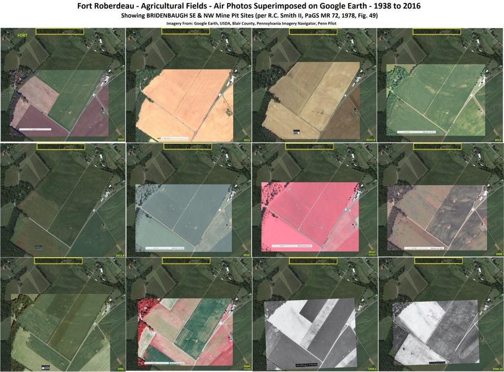
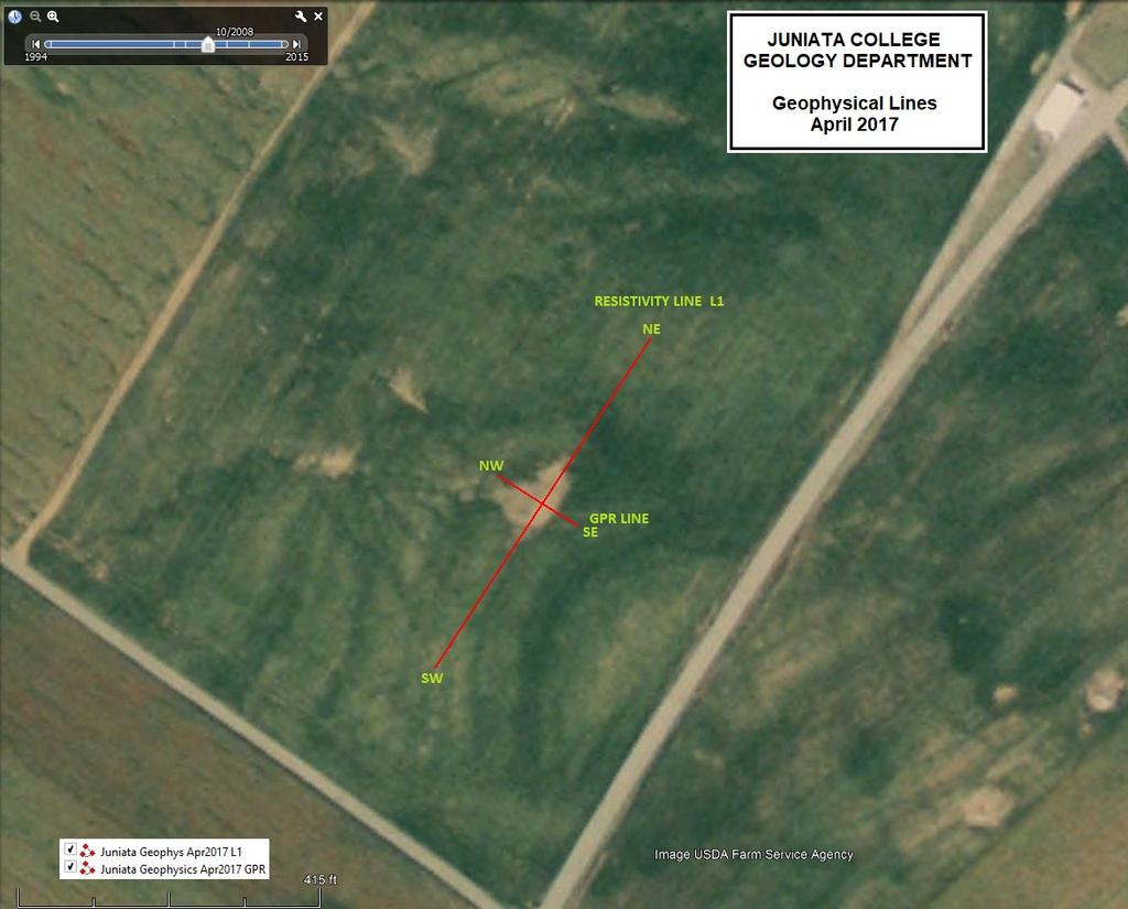
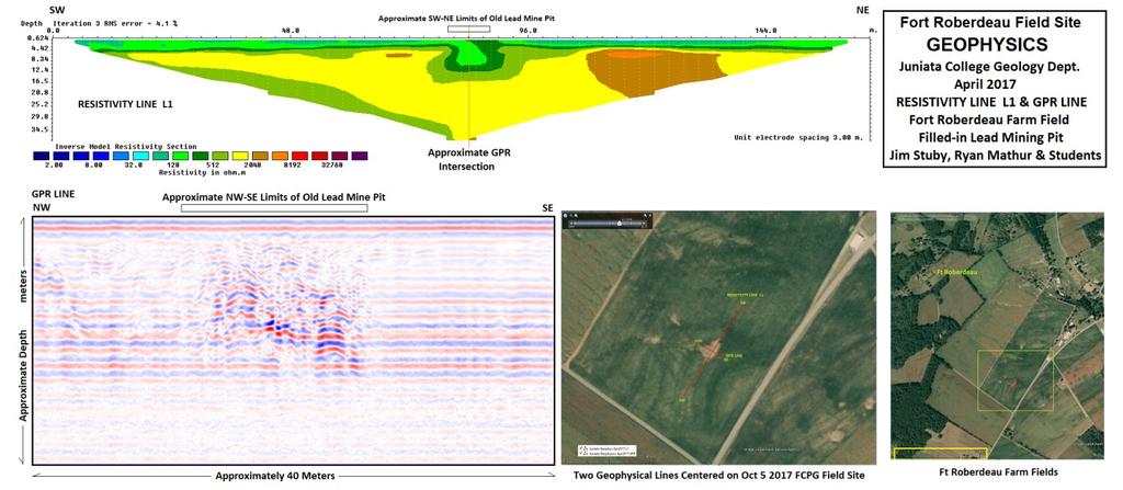
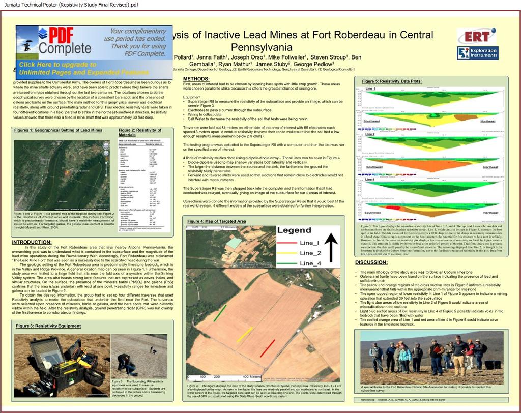
2 Oct 5, 2017 Ft Roberdeau Lead Zinc Mining Area pre-conference field trip v1: 9/18/ Fort Roberdeau Pb-Zn Mining Area Leader: George Pedlow, retired geologist, georgepedlow (at) hotmail.com Limit: unlimited Exertion Level: Easy Fort Roberdeau, in its present form, is a Blair County, Pennsylvania public historic park featuring a modern reconstruction of a Revolutionary War fort. The original fort had been built in 1778 to protect mining operations carried out nearby to secure lead from fracture/breccia mineralization containing galena, sphalerite, barite and other minerals. The Revolutionary War lead mining activity was an attempt to provide military ammunition to the Continental Army. Blair County reconstructed the fort for the 1976 Bicentennial, following up on initial archaeological work done in the late 1930s to define the actual site of the fort. A question repeatedly asked by fort visitors is, Where were the actual mines? The absence of definitively known sites for the 1778 mining effort is a matter of historical interest. The public park lands surrounding the fort site do in fact contain some evidence of old mining, but it is at present unknown if these represent actual 1778 mining. The historical documentary record is poor, and complicated in the field by several iterations of 19th and 20th century lead/zinc exploration attempts. This field trip will visit a (single?) site on the Ft. Roberdeau property where the Juniata College Geology Dept. has used resistivity and GPR geophysics to identify subsurface excavation, now filled with lowgrade mineralized waste rock. Because of the high probability of unharvested crops on the Ft. Roberdeau property, the park will restrict access to only one field site. The plan is to move from the field to the Fort, its museum, and its well equipped meeting hall for further presentations. At the fort museum and on a brief fort tour, we will receive historical background and then convene in the meeting hall for several short presentations of relevant geology, Including geochemistry, mineralogy, geophysics and environmental concerns. Field trip meets at 12:00pm at Arch Spring Farm (40 36'26.27"N, 78 12'8.95"W), owned by George's wife Linda Morrow. Bring a bag lunch and drink. Come at 11:00 if you wish. Attendees will drive themselves to the stops and leave for the conference hotel at 4:30. TO: FCPG Ft Roberdeau Field Trip Attendees - The course of events for the Oct 5, 2017 FCPG pre-conference field trip to Ft Roberdeau will generally be: 1) Gather at Arch Spring Farm for a BYO lunch starting around 11:00 am, and up to about 12:30. NOTE: There are no nearby stores, so plan to bring your BYO lunch & beverage from home, or stop in one of the towns you pass through on the way. Bathrooms will be available, as well as good tap water. Trash containers will be available. Arch Spring Farm is the village of "Arch Spring" on the standard PennDOT road map.
3 WARNING: If you plan to travel north on Kettle Rd. from Altoona, be aware that PennDOT, as of Sep 15, is rebuilding a bridge on Kettle Road between the villages of Culp and Arch Spring. There is a detour in place now, following, in part, the route given on the field trip road log and map. In that case please see the second attachment here showing detailed roads in Sinking Valley. It is marked with a route going past Tytoona Cave, and will serve as a detour around bridge construction. Spring. If you arrive early enough, walk a short distance to view the "Arch" thru which passes the water of Arch An online version of this handout covering the generalities of the day's activities will be available at the FCPG website. 2) Depart for Ft Roberdeau field site ~12:45 pm. Park along NE edge of Ft Roberdeau Rd. ~1:00 pm Directions to the field visit site will be given. If the corn crop in the Ft Roberdeau field has not been harvested as of Oct 5, there will be directions to an access pathway cut into the field site. NOTE: Ft Roberdeau and its surrounding farm land, including the field site, is a Blair County, PA public park. [ Wear good hiking or field boots! 3) Depart for Ft Roberdeau Historic Site parking lot, a short distance NW on Ft Roberdeau Rd, ~2:00 pm. Brief visit to the Ft Roberdeau Museum in the onsite Pennsylvania bank barn; this presents the Revolutionary War historical context of lead mining, and a small collection of specimens. NOTE: We will NOT have enough time to take the historic tour of the fort, situated across the street from the barn museum. 4) Walk uphill to White Oak Hall, the modern conference center in the park, ~2:30 pm. Presentation of a few short (10 to 15 minute) talks on relevant subject matter re: Sinking Valley lead / zinc deposits and groundwater. View posters prepared by Juniata College geology students, and others. 5) Depart for FCPG conference hotel in State College at ~4:30 pm The provided road log (handout - paper & online) will take you past several lead / zinc and other geologic features as you drive toward State College '24.78"N 78 12'10.30"W Parking for lunch at Arch Spring Farm - start gathering at 11 am Oct 5, '32.73"N 78 16'8.37"W Parking for Ft Roberdeau Farm Field visit site - 1 pm Oct 5, '55.01"N 78 16'25.53"W Parking at Ft Roberdeau Historic Site - 2 pm Oct 5, 2017 GPS WARNING: If you are using GPS by address, use: 383 Fort Roberdeau Road, Altoona, PA Make sure that you enter "Fort Roberdeau ROAD" and not Fort Roberdeau AVENUE. The avenue is located in a residential neighborhood in the city of Altoona near Mansion Park. The Fort, located on Fort Roberdeau ROAD, is located in Tyrone Township. NOTE: Please use Lat Lon for Arch Spring Farm; its street address on Kettle Road is "messed up" in several widely used GPS search sites. lists Arch Spring Farm Bed & Breakfast, and presents an interactive Google Maps image showing the exact correct location.
4 Arch Spring Farm: A Short History Linda Morrow Arch Spring Farm is the site of the once thriving small rural village of Arch Spring, still identified as such on PennDOT's standard roadmap. Both are named for the remarkable natural geologic wonder located on the farm property - Arch Spring - with its natural limestone arch and voluminous flow. It has been noted in publications, and visited continuously, as a site of natural beauty for well over 200 years. It can only be assumed that Native Americans knew of, and wondered at, this place long before that. Dave and Linda Morrow bought Arch Spring Farm in 1983, virtually a life-long dream for Dave, who had grown up on a farm two miles away. They restored the smaller Mill House in 1986 and the larger Manor House, the Jacob Isett house, ten years later. Linda and her family have continued to operate both as a B&B since Dave s passing. Jacob Isett came to Sinking Valley in He had been a shoemaker as well as a gristmill operator in the southeastern part of Pennsylvania. When he arrived in Sinking Valley he lived in an abandoned building at Ft. Roberdeau and earned his living making shoes which he traded for grain. He amassed a lot of wheat in a year before crop failure and so was able to sell his grain for enough money to buy the land at Arch Spring from William Penn's heirs in 1795, it having been part Lot 33 of the Penn's Manor of Sinking Valley. Jacob Isett first built the small stone structure that is now behind the main house. The ground floor would have been used as kitchen/living room and the upstairs as sleeping quarters. The second floor is interesting as it has 4 slits for windows which are wider on the inside than the outside. This design permitted a rifle to be aimed at attacking Indians or other intruders. The British had enlisted Indians to help them in the Revolutionary War, so there may have still been unfriendly natives around when the fort was built. Between each set of windows are indentations of the same design that Dave and Linda had seen in Fort Michilimackinac, another Revolutionary War fort in upper Michigan. They were told there that the indentations were to hold ammunition. Jacob Isett built a saw mill and a very large wooden grist mill next to the stone building now called the Mill House. He diverted some of the stream from the spring into a mill race. The upstream end of that mill race can be seen near the road bridge crossing Arch Spring's outflow. The wooden mill was dismantled in 1942, but the covered bridge like structure, a scale house, still stands. Wagons were weighed empty and again with grain to determine the weight of the grain milled or sold. The works for the balance scale can still be seen. A blacksmith and wagon shop, a shoemaker s shop and a cider press were once part of the village in the 1850s. Remains of the foundations of small homes can be seen on the other side of the modern foot bridge. The Mill House was historically a commercial building, having served variously as a general store, warehouse for the grist mill, and Arch Spring Post Office. There is no evidence of an original early chimney, indicating that it was not built for habitation. It is intriguing to think that the Mill House might have been built in 1799 because of a threshold stone carved ISETT 1799 in the building. However, the location of the stone, with lettering facing upward, on the threshold of the warehouse door 3 stories above the ground, may indicate that the stone was recycled from an earlier location. A Penn State historical geographer estimated the Mill House was built in the 1830 s, but there is also an interesting architectural similarity to the 1817 version of Sinking Valley Church, of which a good photograph survives, taken in the 1870s before that church was rebuilt in its present form. The plaque just under the gable at the north end of the Manor House indicates the building was completed in 1805 for Jacob and Eleanor Isett. Other stone houses of very similar design and trim exist in the Olny Valley of SE PA, so it may be the builder came from there and might have brought mill work and other building materials with him. Both houses at Arch Spring, viewed together, share architectural features with the Lemon House that served primarily as a restaurant and bar to patrons of the Allegheny Portage Railroad. Originally the Manor house had no insulation, just plaster and wall paper and chair rail over the inside of the stone walls. It was probably the early 1900 s, when electricity was put in, that the perimeter walls were studded and plaster was applied over lathe. In the 1920 s there was a major fire in the living room which apparently destroyed the original woodwork there. Very ugly 1920 s woodwork was taken out in the 1996 restoration. The built-in cabinets in the dining room are believed to be original to the house. When indoor plumbing was installed, maybe during fire damage repairs, a bathroom was added at the front of the upstairs hall. There were originally 5 bedrooms on the second floor with the 5th bedroom accessible only by the former back stairwell or through another bedroom. In 1996 the 5th bedroom was converted into two more bathrooms and an upstairs laundry. The Manor House now has two geothermal furnaces and hot water heaters. The pipes run under the field to the north of the house. At the start of Mill House restoration in 1986, there were no studded or plastered walls, and of course no insulation. Although these features were added, heating is electric, so the building is winterized every year from January at least into April.

5 Oct 5, 2017 FCPG Pre-Conference Field Trip Driving Route from Arch Spring Farm lunch / gathering site to Fort Roberdeau, and from the Fort to the conference hotel in State College, PA. NOTE: The Sinking Valley portion of the Driving Route between Ft. Roberdeau and Arch Spring is coincident with PennDOT s detour around the bridge project. SEE: Road Log at the end of this document.

6 Property boundary map of the Fort Roberdeau Blair County historic park, showing relative locations of places to be visited on the Oct 5, 2017 FCPG Pre-Conference Field Trip. The present extent of property owned by Blair County at the Fort Roberdeau historic site has been assembled over many decades through purchase and donation. Space here does not permit a full description of the effort. Suffice it to say that since the 1930s, a Kiwanis youth camp, situated where White Oak Hall now stands, and portions of several farms have been joined together to form the present park. Published articles by interested folks had appeared fairly frequently since the latter 19 th century. The Altoona chapter of DAR placed the bronze historical matker along Kettle Road in A Depression era effort in archaeology and actual reconstruction of the fort was undertaken in the late 1930s, only to be set aside at the onset of WW II. Blair County revitalized the reconstruction plan in the early 1970s as a Bicentennial project. The Fort and its interior features are the result of that effort. The Museum barn is, of course, a long standing Pennsylvania Bank Barn, a historic structure in its own right. Staff at the fort complex host a variety of functions, from historic tours for members of the general public, to school tours, colonial and Revolutionary War, and other, reenactor events, meetings and public presentations, and rental for private parties such as weddings.
7

8
9

10 ROAD LOG Reiterating critical location information: 40 36'24.78"N 78 12'10.30"W Parking for lunch at Arch Spring Farm - start gathering at 11 am Oct 5, '32.73"N 78 16'8.37"W Parking for Ft Roberdeau Farm Field visit site - 1 pm Oct 5, '55.01"N 78 16'25.53"W Parking at Ft Roberdeau Historic Site - 2 pm Oct 5, 2017 GPS WARNING: If you are using GPS by address, use: 383 Fort Roberdeau Road, Altoona, PA Make sure that you enter "Fort Roberdeau ROAD" and not Fort Roberdeau AVENUE. The avenue is located in a residential neighborhood in the city of Altoona near Mansion Park. The Fort, located on Fort Roberdeau ROAD, is located in Tyrone Township. NOTE: Please use Lat Lon for Arch Spring Farm; its street address on Kettle Road is "messed up" in several widely used GPS search sites. lists Arch Spring Farm Bed & Breakfast, and presents an interactive Google Maps image showing the exact correct location.
11
12
Cranberry Lake Farm. By Alicia McCullough for the Oakland Township HDC
 Cranberry Lake Farm By Alicia McCullough for the Oakland Township HDC Cranberry Lake Farm s History Cranberry Lake Farm was purchased by Seymour Fletcher in 1837 from the Federal Government. The development
Hudson Valley Vernacular Architecture Dutch Barn Preservation Society Field Trip to the Palatine Region of the Mohawk Valley May 18, 2013
 Hudson Valley Vernacular Architecture Dutch Barn Preservation Society Field Trip to the Palatine Region of the Mohawk Valley May 18, 2013 Trip Schedule Site Arrive Depart Old Palatine Church 10:30 am 11:15
United States Department of the Interior National Park Service. Boundary Expansion Listed in National Register January 11, 2017
 NPS Form 10900-a (Rev. 8/2002) OMB No. 10240018 United States Department of the Interior National Park Service Boundary Expansion Listed in National Register January 11, 2017 National Register of Historic
Eastern Section Spring Conference May 30- June 2, 2013
 The National Association of Geoscience Teachers Eastern Section Spring Conference May 30- June 2, 2013 Hosted at Lock Haven, PA Geological Excursions in the Allegheny Plateau and Valley and Ridge sections
M U S E U M S. Bradford County. Experience an unforgettable journey through over two centuries of history.
 A COMPREHENSIVE GUIDE TO Bradford County PENNSYLVANIA Experience an unforgettable journey through over two centuries of history. M U S E U M S This is your official PASSPORT THROUGH HISTORY See contest
Ontario Municipal Board Commission des affaires municipales de l Ontario
 ISSUE DATE: January 27, 2014 PL130137 Ontario Municipal Board Commission des affaires municipales de l Ontario Peter Eliopoulos has appealed to the Ontario Municipal Board under subsection 22(7) of the
The Covered Bridge of Pepperell
 The Covered Bridge of Pepperell 1742 - An uncovered wooden bridge historically referred to as the cart bridge at Joseph Blood s Fordway, links Groton West Parish and Groton. Cost Unknown 1753 - As Pepperell
THE HEUGH LINDISFARNE
 LINDISFARNE COMMUNITY ARCHAEOLOGY THE HEUGH LINDISFARNE Archaeological excavations in June 2017 Invitation to volunteers THE HEUGH, LINDISFARNE, NORTHUMBERLAND: ARCHAEOLOGICAL EXCAVATIONS 2017 INTRODUCTION
Portway Farm, Twyford
 Portway Farm, Twyford Buckinghamshire Archaeological Society HISTORIC BUILDING REPORT / April 2011 Including HS2 high-speed rail line Impact Assessment SURVEY AND REPORT: Sue Fox and John Brushe Report
Doylestown Historical Society local history collection
 15 Finding aid prepared by Celia Caust-Ellenbogen and Faith Charlton through the Historical Society of Pennsylvania's Hidden Collections Initiative for Pennsylvania Small Archival Repositories. Last updated
STATEMENT OF SIGNIFICANCE
 1765 Columbia Avenue - Miners Union Hall Miners Hall 2012 Heritage Register - Building 1) Historical Name: Miners Union Hall 2) Common Name: Miners Hall 3) Address: 1765 Columbia Avenue 4) Date of Construction:
MP : Snowy Range Road and the Hoop Creek Bridge
 MP 246 247: Snowy Range Road and the Hoop Creek Bridge This section of U. S. Highway 40 contains a Colorado treasure, a great photo op, and a historical landmark all at one stop. It s the Hoop Creek Stone
chapter - Hex Highway Touring Route Hamburg to Strausstown Overview
 chapter - 2 Hex Highway Touring Route Hamburg to Strausstown Overview The on-road Hex Highway automobile and bicycle touring route begins on State Street in downtown Hamburg. The route continues west on
Langley Register of Historic Places Nomination Form
 FOR OFFICE USE ONLY Langley Register of Historic Places Nomination Form Received Type all entries 1. Name of Property Historic: Jacob Anthes Bunkhouse/Cookhouse And/or common: South Whidbey Historical
Shelter Rentals NEW Zoo, Adventure Park and Reforestation Camp Ski Lodge Ski Lodge Meeting Room
 Shelter Rentals NEW Zoo, Adventure Park and Reforestation Camp The NEW Zoo and Adventure Park has two rental shelter buildings available for group functions. The Pines Shelter is located by the Lower Parking
Boll s Brewhouse: 45 North Market Street, Elizabethtown Pennsylvania
 Hon 170: Elizabethtown History: Campus and Community Joseph Santos Professor Benowitz 5 May 2017 Boll s Brewhouse: 45 North Market Street, Elizabethtown Pennsylvania Abstract: Henry Boll s Brewery operated
Redsecker Residence: 244 South Market Street; Elizabethtown, Pennsylvania
 Hon 170: Elizabethtown History: Campus and Community Joseph Santos Professor Benowitz 5 May 2017 Redsecker Residence: 244 South Market Street; Elizabethtown, Pennsylvania Abstract: The Redsecker Residence,
Other Principle Arterials Minor Arterial Major Collector Minor Collector Local
 CHAPTER 10 TRANSPORTATION Introduction The system of public roads in East Pikeland Township is decidedly rural in character. Since the 1984, the road network has remained much the same, with the addition
Camp Indian Springs. Sales Associate Colleen Castille Village Square Blvd #3-302, Tallahassee, FL 32312
 This camp has been the go-to over-night camp for old Tallahassee families for 65 years. The camp was started by a Tallahassee family, Betty Palmer and Odette Marshal and their families who built the camp
O HARA TOWNSHIP. Chapter 2 - Early History. Comprehensive Development Plan
 O HARA TOWNSHIP Chapter 2 - Early History The O Hara Township History Committee has assembled a significant volume of historical data from primary and secondary sources, about persons, places and events
Friends Meeting House, Hitchin. 1 Paynes Park, Hitchin, Hertfordshire, SG5 1EH. National Grid Reference: TL Statement of Significance
 Friends Meeting House, Hitchin 1 Paynes Park, Hitchin, Hertfordshire, SG5 1EH National Grid Reference: TL 18282 29279 Statement of Significance A meeting house of 1957 designed by Paul V. Mauger and erected
TOWNSHIP OF HILLSIDE, NJ.
 TOWNSHIP OF HILLSIDE, NJ. HILLSIDE Formed as Township: 1913 1970 Population: 21,636 Land Area 2.70 square miles The initial settlement of the township now known as present day Hillside followed shortly
History Alive. The Lake Champlain Region is rich with history, all within 50 miles of your hotel door. For google map:
 History Alive The Lake Champlain Region is rich with history, all within 50 miles of your hotel door. For google map: http://goo.gl/maps/zak1c The Route 1. Lake Champlain Maritime Museum on property 2.
As seen in the Spring 2009 issue of ALASKA HOME magazine
 Photo courtesy of Jacquie Haydon As seen in the Spring 2009 issue of ALASKA HOME magazine 54 ALASKA HOME Spring 2009 The house Lthatl love built and rebuilt A Fairbanks house on the National Historic Registry
THE MANIFEST January 2015
 THE MANIFEST January 2015 The new year has begun and work continues on the track-laying project at the Park. It is hard to believe we only have two more months before we open again! I for one am looking
SUTTER COUNTY. General Plan Update Technical Background Report
 SUTTER COUNTY General Plan Update Technical Background Report February 2008 SUTTER COUNTY GENERAL PLAN UPDATE TECHNICAL BACKGROUND REPORT PREPARED FOR: SUTTER COUNTY PREPARED BY: PBS&J IN PARTNERSHIP
Heritage Economics: Community, (Re) Development & Tourism
 Development & Tourism") 31 st Annual Virginia Preservation Conference Heritage Economics: Community, (Re) Development & Tourism Preliminary Program at a glance (8/10/16) October 16-17, 2016 Charlottesville, Virginia Sunday, October
31 st Annual Virginia Preservation Conference Heritage Economics: Community, (Re) Development & Tourism Preliminary Program at a glance (8/10/16) October 16-17, 2016 Charlottesville, Virginia Sunday, October
Historical Journal L I T I T Z H I S T O R I C A L F O U N D A T I O N. P.O. Box E. Main Street, Lititz, PA
 Historical Journal L I T I T Z H I S T O R I C A L F O U N D A T I O N P.O. Box 65 145 E. Main Street, Lititz, PA 17543 717-627-4636 By Charlene Van Brookhoven As you leave Lititz heading east on Rt. 772
APPENDIX L -4 RECREATIONAL TRAIL CROSSING PLANS
 Atlantic Sunrise Project PA DEP Chapter 105 Joint Permit Application Transcontinental Gas Pipe Line Company, LLC Lancaster County APPENDIX L -4 RECREATIONAL TRAIL CROSSING PLANS Atlantic Sunrise Project
Making Camp. Little did Cynthia and Kirk Dupps know that their. Arkansas family creates a fun-filled getaway. Story by Tracy Maruschak
 Making Camp Arkansas family creates a fun-filled getaway Story by Tracy Maruschak Photography by Brad Simmons Little did Cynthia and Kirk Dupps know that their search for the perfect property would lead
HISTORICAL MARKERS issued by
 HISTORICAL MARKERS issued by INDIANA HISTORICAL BUREAU in MONTGOMERY COUNTY, INDIANA 2016 Compiled by Dian Moore, Montgomery County historian NUMBER NAME 54.1962.1 Lane Place 54.1963.1 Major General Lew
Vladivostok, Russia Day 12 Oct. 9:
 Vladivostok, Russia Day 12 Oct. 9: The Amsterdam was docked in Vladivostok by 6am. It was still dark outside but the nearby train station that serves as the Eastern Terminal of the Trans-Siberian Railroad
Comments by the Laverstock and Ford Parish Council on Draft Old Sarum Conservation Area Management Plan (MP) CMP RevA11 Jun 2014.
 CMP RevA11 Jun 2014.") Comments by the Laverstock and Ford Parish Council on Draft Old Sarum Conservation Area Management Plan (MP) - 6731 CMP RevA11 Jun 2014. Comment Ref Page Ref Section Remarks 1 Page 4 Background Reference
Comments by the Laverstock and Ford Parish Council on Draft Old Sarum Conservation Area Management Plan (MP) - 6731 CMP RevA11 Jun 2014. Comment Ref Page Ref Section Remarks 1 Page 4 Background Reference
Northern pa hunting cabins for sale
 Mountain homes and land for sale, mountain retreats, mountain cabins, ski properties, mountain resorts across the nation. Upper Manistee River. The Upper Manistee River Access Action Plan Final Report.
Holyport Manor Special School, Highfield Lane, Cox Green, Maidenhead, Berkshire
 Holyport Manor Special School, Highfield Lane, Cox Green, Maidenhead, Berkshire An Archaeological recording action For CgMs Consulting by Jennifer Lowe Thames Valley Archaeological Services Ltd Site Code
BARODA TOWNSHIP OPEN BURNING ORDINANCE. Ordinance No. 35
 BARODA TOWNSHIP OPEN BURNING ORDINANCE Ordinance No. 35 TABLE OF CONTENTS Section 1: Authority. 2 Section 2: Purpose...2 Section 3: Applicability......2 Section 4: Definitions...2 Section 5: Open burning
Ballasalla House BALLASALLA ISLE OF MAN
 Ballasalla House BALLASALLA ISLE OF MAN Ballasalla House BRIDGE ROAD BALLASALLA ISLE OF MAN IM9 3DQ Splendid edge of village Georgian Manor House with barn and outbuildings Woodland, mill pond and lovely
RAY YENKANA Willowbrook Cr, Dawson Creek BC Canada $2,847,000
 1716 Willowbrook Cr, Dawson Creek BC Canada For SALE $2,847,000 This is a rare find, 32 townhomes in Dawson Creek, BC. Excellent investment in a single title multi family complex. Vendor has upgraded this
Learning Places Spring 2016 LIBRARY / ARCHIVE REPORT LaGuardia & Wagner Archives KYRA CUEVAS INTRODUCTION PRE-VISIT REFLECTION
 Learning Places Spring 2016 LIBRARY / ARCHIVE REPORT LaGuardia & Wagner Archives KYRA CUEVAS 04.06.2016 INTRODUCTION The LaGuardia & Wagner NYCHA archives was our third library and archive trip. Upon visiting
Hwy Retaining Wall/ Sea Wall. Not Eligible, see Statement of Significance Also member of listed NR district: Mantorville Historic District
 Historic Name CS # 2007 Other Name SHPO Inv # Location E and W sides of TH 57 between 6th St and 7th St Hwy District Reference City/Township County Mantorville, City of Dodge Acres Twp Rng Sec 107N 16W
Heritage Economics: Community, (Re) Development & Tourism
 Development & Tourism") 31 st Annual Virginia Preservation Conference Heritage Economics: Community, (Re) Development & Tourism Conference Program at-a-glance (9/14/16) October 16-17, 2016 Charlottesville, Virginia Sunday, October
31 st Annual Virginia Preservation Conference Heritage Economics: Community, (Re) Development & Tourism Conference Program at-a-glance (9/14/16) October 16-17, 2016 Charlottesville, Virginia Sunday, October
Reservoir Tin workings
 The workings are quite over-grown and covered in moss, suggesting that they date to the earliest period of mining. This is supported by the fact that their head race was cut off by the reservoir (D49/47)
WALTON MARSH RAILROAD TIES
 WALTON MARSH RAILROAD TIES A PROJECT SURVEY BY COLIN FRYE Supervisor: Dr. Mark Holley The Walton Marsh Railroad Tie project involved the survey and study of six railroad ties discovered in and on the shoreline
FLAGLER WORKER S HOUSE FORT DALLAS PARK S.E. 4 STREET
 FLAGLER WORKER S HOUSE FORT DALLAS PARK 60-64 S.E. 4 STREET Designation Report City of Miami REPORT OF THE CITY OF MIAMI PLANNING DEPARTMENT TO THE HERITAGE CONSERVATION BOARD ON THE POTENTIAL DESIGNATION
Camp Wilderness Winter Camp
 Camp Wilderness Winter Camp Camp Phone: 218-732-4674 Dates: Winter Camp begins December 9 th, 2016, with the Cub Scout Winter Wonderland weekend, and runs every weekend January 6 th through March 5 th,
Brief Highlights of Mission La Purisima Concepcion
 From the City of Lompoc Web Site Created and Maintained by City of Lompoc Information Services Division A very special thanks to the Lompoc Valley Historical Society and all the good folks for sharing
APPENDIX OFFICIAL MAP ORDINANCE OF HAMILTONBAN TOWNSHIP OFFICIAL MAP NARRATIVE
 APPENDIX A OFFICIAL MAP ORDINANCE OF HAMILTONBAN TOWNSHIP OFFICIAL MAP NARRATIVE INTRODUCTION: The Official Map of Hamiltonban Township has been prepared to identify those lands and features that Hamiltonban
Waterways and Floods. by Michael Pearce. Smith-Layton Archive. Sponsored by Linda L. Lester
 Smith-Layton Archive Waterways and Floods Charlene Duval, Executive Secretary cduval@sourisseauacademy.org Leilani Marshall, Archivist lmarshall@sourisseauacademy.org by Michael Pearce Phone: 408 808-2064
BRADDOCK'S WAR SUPPLIES AND DUNBAR'S CAMP 1
 I934 braddock's war supplies 49 BRADDOCK'S WAR SUPPLIES AND DUNBAR'S CAMP 1 /-\u25a0-a he following is the story of how the war supplies of General JL Braddock, which he discarded in his hasty retreat
INLAND STEEL COMPANY, INDIANA HARBOR WORKS PHOTOGRAPHS,
 Collection # P 0711 INLAND STEEL COMPANY, INDIANA HARBOR WORKS PHOTOGRAPHS, 1926 Collection Information 1 Historical Sketch 2 Scope and Content Note 3 Contents 4 Processed by Dalton Gackle July 2018 Manuscript
Frequently Asked Questions
 Frequently Asked Questions Who should attend the tours? People interested in hearing about and seeing the real Mackinac Island will enjoy this tour. Mackinac Revealed is the only source of Island information
Verdley Edge Henley Hill, Haslemere, Surrey. People Property Places
 Verdley Edge Henley Hill, Haslemere, Surrey People Property Places A well presented period house, originating from the 14th Century with Georgian and later additions, now providing generous accommodation
Cave and Basin & Castle Internment Camp Site Visit Report Sarah Beaulieu December 7, 2015
 Cave and Basin & Castle Internment Camp Site Visit Report Sarah Beaulieu December 7, 2015 Figure 1.1 Cave and Basin National Historic Site Internment Exhibit Banff National Park was the site of two internment
WEST HEMPFIELD TOWNSHIP 3401 MARIETTA AVENUE LANCASTER, PA WEST HEMPFIELD TOWNSHIP ZONING HEARING BOARD June 11, 2013
 WEST HEMPFIELD TOWNSHIP 3401 MARIETTA AVENUE LANCASTER, PA 17601 WEST HEMPFIELD TOWNSHIP ZONING HEARING BOARD The West Hempfield Township Zoning Hearing Board met in the meeting room of the West Hempfield
WEST PITTSBURGH POPULATION TREND ::: ,000 9,000 8,000 TOTAL POPULATION 7,000 6,000 5,000 4,000 3,000 2,000
 ELLIOTT A HOLISTIC STUDY of the physical and aesthetic DETAILS, CHARACTERISTICS, AND INTERVENTIONS Department of Landscape Architecture College of Arts and Architecture The Pennsylvania State University
State Level Historic Documentation Report. John Blue Bridge Hampshire County
 State Level Historic Documentation Report State Project No. S314-28-22.27 Federal Project No. BR-0028(058)D John Blue Bridge Hampshire County Prepared by: Randy Epperly, Historian Department of Transportation
Modular Log Cabins & Log Homes Alan's Factory Outlet Luray VA
 1 2 2 Your special place to reflect, retreat, and rejuvenate. Your Cabin - The Place Where The World Stands Still And Life Begins The Settler Cabin Weekend outings should be a time to relax and unwind
Lyons. photo by Richard Palmer Layton Road
 Lyons 3532 Layton Road Construction commenced on the Jackson one-room school house at 336 Pleasant Valley Road, Lyons, in 1829. It was completed in 1831 at a cost of $187. It was named for President Andrew
HEADQUARTERS WEST LTD. PHOENIX - TUCSON - SONOITA - COTTONWOOD - ST. JOHNS
 Offered for sale exclusively by: Walter Lane Headquarters West, Ltd. PO BOX 37018 Tucson, AZ 85740 Phone (520) 792-2652 info@headquarterswest.com www.headquarterswest.com General Area Description The Crown
W E L C OM E TO BAC K Y AR D N AT U R E C E N TER S SITE R E SOURCE PAC K E T S!
 LITTLE HOUSE OF GLENCOE Last updated September 7, 2011 W E L C OM E TO BAC K Y AR D N AT U R E C E N TER S SITE R E SOURCE PAC K E T S! BackYard Nature Center (BYNC) has selected and described six nature
CARLUNGIE EARTH HOUSE
 Property in Care (PIC) ID: PIC015 Designations: Scheduled Monument (SM90059) Taken into State care: 1953 (Guardianship) Last reviewed: 2004 HISTORIC ENVIRONMENT SCOTLAND STATEMENT OF SIGNIFICANCE CARLUNGIE
Nittany Mountain District Spring Camporee 2017
 Nittany Mountain District Spring Camporee 2017 April 28-30, 2017 Seven Mountains Scout Camp NITTANY MOUNTAIN DISTRICT - JUNIATA VALLEY COUNCIL, B.S.A. 2017 SPRING CAMPOREE STAFF Camporee Chairman Program
Stobs Camp Project Quarter 1 Report April June 2018
 Stobs Camp Project Quarter 1 Report April June 2018 Executive Summary During this period the project ran an excavation at two fortification practice trenches. Adult volunteers and school pupils were able
A History of the Detroit Riverfront. From 1760 though to the
 A History of the Detroit Riverfront From 1760 though to the Detroit attracts immigrant workers 176o-1800 AD 1805 AD A devastating fire sweeps through Detroit, destroying all 200 of its structures except
GRUENE HOMESTEAD INN & TAVERN IN THE GRUENE 830 & 832 Gruene Road, New Braunfels, TX For Sale
 GRUENE HOMESTEAD INN & TAVERN IN THE GRUENE 830 & 832 Gruene Road, New Braunfels, TX 78130 For Sale Gruene Homestead Inn & Tavern in the Gruene are two businesses centrally located in New Braunfels and
Finding aid for the Grand Rapids and Indiana Railroad Company collection Collection 190
 Finding aid for the Grand Rapids and Indiana Railroad Company collection Collection 190 Finding aid prepared by James B. Winslow This finding aid was produced using the Archivists' Toolkit May 13, 2014
The meeting house is a converted Plymouth Brethren Chapel which originally was two cottages. It has medium significance.
 Quaker Meeting House, Ashburton Foales Court, off North Street, Ashburton, Devon, TQ13 7QE National Grid Reference: SX 75574 69951 Statement of Significance The meeting house is a converted Plymouth Brethren
District Five 2016 Fall Tour Schedule
 District Five 2016 Fall Tour Schedule Welcome to the 2016 WMSPA Fall Tour We want to thank you all for joining us today and we would especially like to thank the members who gave their time in putting
ARDESTIE EARTH HOUSE HISTORIC ENVIRONMENT SCOTLAND STATEMENT OF SIGNIFICANCE. Property in Care no: 24
 Property in Care no: 24 Designations: Scheduled Monument (SM90021) Taken into State care: 1953 (Guardianship) Last reviewed: 2004 HISTORIC ENVIRONMENT SCOTLAND STATEMENT OF SIGNIFICANCE ARDESTIE EARTH
CARVER S FALLS. Cumberland County s Natural Beauty. What s Included In This Information Packette
 Cumberland County s Natural Beauty What s Included In This Information Packette History of the Falls Boy Scouts have acquired Right of Use Guidelines for Usage Application Check-out Report HISTORY AND
Just under a mile from Cawfields car park where the walk begins is Great Chesters Roman Fort. It is behind the tree, looking from the west.
 Tynedale U3A Hadrian s Wall Group Cawfields to Birdoswald Just under a mile from Cawfields car park where the walk begins is Great Chesters Roman Fort. It is behind the tree, looking from the west. Great
Bike MS Ride, West Michigan Riding In Historical Allegan County
 Bike MS Ride, West Michigan Riding In Historical Allegan County The Michigan Chapter of the National MS Society would like to extend our gratitude to the Steering Committee for the West Michigan Bike MS
MEDIA ADVISORY. FOR IMMEDIATE RELEASE November 12, 2012
 MEDIA ADVISORY FOR IMMEDIATE RELEASE November 12, 2012 Niagara-on-the-Lake On Monday, November 19, 2012, the Lord Mayor and members of the Town s Municipal Heritage Committee and War of 1812 Bicentennial
MEMORANDUM. DATE: May 16, TO: Monica Harrower, PennDOT District 6-0. Mary Alfson Tinsman CHRS, Inc. 451 North Cannon Avenue, Suite 100B
 MEMORANDUM DATE: May 16, 2011 TO: Monica Harrower, PennDOT District 6-0 FROM: RE: Mary Alfson Tinsman CHRS, Inc. 451 North Cannon Avenue, Suite 100B Lansdale, PA 19446 French Creek Parkway Project Phoenixville
Hickman s (Diamond) Mills
 Mills") Hickman s (Diamond) Mills On the east branch of Naaman's Creek, near the northwest boundary of Lower (and Upper) Chichester townships, was the saw- and grist-mill of Samuel Hickman, which was one of the
Hickman s (Diamond) Mills On the east branch of Naaman's Creek, near the northwest boundary of Lower (and Upper) Chichester townships, was the saw- and grist-mill of Samuel Hickman, which was one of the
Corporate Environmental Leadership Seminar Yale School of Forestry & Environmental Studies June 4-15, 2000
 KLEE 443 Corporate Environmental Leadership Seminar Yale School of Forestry & Environmental Studies June 4-15, 2000 Robert J. Klee M.E.S., Yale School of Forestry & Environmental Studies, 1999 ECO-INDUSTRIAL
Peru October days/6 nights Approximate Cost $2,230 Double / $3,080 Single
 Peru October 8 14 2019 7 days/6 nights Approximate Cost $2,230 Double / $3,080 Single We need to have at least 15 people signed up for the trip by June 15 th or the trip maybe cancelled. Day 1 ARRIVAL
Landscove Barns Region: Devon Sleeps: 12-20
 Landscove Barns Region: Devon Sleeps: 12-20 Overview Featured in The Sunday Times The Best Christmas Holiday Escapes 2017 First constructed from Cornish and Devonshire stone over 200 years ago, this barn
Lancaster Castle THE CASTLE STUDIES GROUP JOURNAL NO 26:
 Lancaster Castle. The Henry IV gatehouse from the south-east. The C15 gatehouse subsumes a C12/13 stone gateway, observable inside the gate passage beyond the portcullis. The lower level loops originally
Camp Kintail. Rental Information Package
 Camp Kintail Rental Information Package 2019 On the shores of Lake Huron, Camp Kintail is the perfect place to get away and experience nature. Come and Stay With Us The facilities at Camp Kintail are available
HO, HO, HO, SAID OUR OPEN HOUSE VISITOR
 2013 HO, HO, HO, SAID OUR OPEN HOUSE VISITOR Feb 2&3, Great Train Expo, Timonium, MD Feb 23&24, Greenburg Train Show, VA Beach For more information on these shows - Google or go to http:// www.trainweb.org/
The Triple Divide Trail System: Building an Eco-Tourism Corridor as a Strategy for River Conservation
 The Triple Divide Trail System: Building an Eco-Tourism Corridor as a Strategy for River Conservation William Hart, President Genesee River Wilds, Belmont, NY in collaboration with Allen Kerkeslager, Saint
Chateau De La Guerinche Region: Dordogne Guide Price: 3,684-5,263 per week Sleeps: 12
 Chateau De La Guerinche Region: Dordogne Guide Price: 3,684-5,263 per week Sleeps: 12 Image not readable or empty typo3conf/ext/olivers_travels/resources/public/img/pdf-l Overview This stunning 17th century
Trench 91 revealed that the cobbled court extends further to the north.
 Report on the 2013 Gournia Excavations The 2013 excavations at Gournia were conducted June 17 July 26 under the aegis of the American School of Classical Studies at Athens and the supervision of the KD
Camp Wilderness Winter Camp
 Camp Wilderness Winter Camp Camp Phone: 218-732-4674 Dates: Winter Camp begins December 8 th, 2017, with the Cub Scout Winter Wonderland weekend, and runs every weekend January 5 th through March 4 th,
Betty J. Strecker Doylestown Sesquicentennial records
 14 Finding aid prepared by Celia Caust-Ellenbogen and Faith Charlton through the Historical Society of Pennsylvania's Hidden Collections Initiative for Pennsylvania Small Archival Repositories. Last updated
Tourism Potential. Resources and Value. Security
 For Sale a rare gem along the Klaserie River. Portion 159 of the farm Guernsey, near the town of Klaserie in the Limpopo province. GPS location 24 28'59 S 31 05'18 E (decimal 24.48324S 31.08864E). Land
DETROIT, TOLEDO, AND IRONTON RAILROAD PHOTOGRAPHS SUBSERIES, Accession 548
 Finding Aid for DETROIT, TOLEDO, AND IRONTON RAILROAD PHOTOGRAPHS SUBSERIES, 1922-1923 Finding Aid Published: June 2011 20900 Oakwood Boulevard Dearborn, MI 48124-5029 USA research.center@thehenryford.org
An Example of Small Scale Geothermal Energy Sustainability: Chena Hot Springs, Alaska. Mink, Leland; Karl, Bernie; and Karl, Connie
 Proceedings World Geothermal Congress 2015 Melbourne, Australia, 19-25 April 2015 An Example of Small Scale Geothermal Energy Sustainability: Chena Hot Springs, Alaska Mink, Leland; Karl, Bernie; and Karl,
THE CORPORATION OF THE TOWN OF NIAGARA-ON-THE-LAKE. BY-LAW NO (214 Four Mile Creek Road)
") THE CORPORATION OF THE TOWN OF NIAGARA-ON-THE-LAKE BY-LAW NO. 4807-15 (214 Four Mile Creek Road) A BY-LAW TO DESIGNATE THE PROPERTY KNOWN MUNICIPALLY AS WOODBOURNE, 214 FOUR MILE CREEK ROAD, IN THE TOWN
THE CORPORATION OF THE TOWN OF NIAGARA-ON-THE-LAKE BY-LAW NO. 4807-15 (214 Four Mile Creek Road) A BY-LAW TO DESIGNATE THE PROPERTY KNOWN MUNICIPALLY AS WOODBOURNE, 214 FOUR MILE CREEK ROAD, IN THE TOWN
Camp Wilderness Winter Camp
 Camp Wilderness Winter Camp Camp Phone: 218-732-4674 Dates: Winter Camp begins December 7 th, 2018, with the Cub Scout Winter Wonderland weekend, and runs every weekend January 4 th through March 3 rd,
The Holes Creek Bridge Replacement By Bradley McClelland
 The Holes Creek Bridge Replacement By Bradley McClelland Each time there is a heavy rainstorm, the folks along Sheffield Road in the Dayton, Ohio suburb of West Carrollton have cause to be concerned. Holes
Ground Penetrating Radar Survey Report:
 Ground Penetrating Radar Survey Report: German Hospice in Jerusalem, Israel Data Acquired June 19, 2003 Report compiled August 26, 2003 Survey and Report Published by Mnemotrix Systems, Inc. Copyright
9 Illustrations. Barrett Farm Historic Structure Report April 17, Historic Maps and Views. New England Landmarks Save Our Heritage, Inc.
 Barrett Farm Historic Structure Report April 17, 2009 63 9 Illustrations 9.1 Historic Maps and Views Figure 23 Barrett Farm Lossing c.1848 The earliest view of the house with west ell much as it is today.
Unique Townhome with Access to an Outdoor Pool and Hot Tub!
 Unique Townhome with Access to an Outdoor Pool and Hot Tub! Summary 3 BR 2 Bath Townhome - sleeps up to 9 Description 1926 Soda Springs II - a SkyRun Keystone Property Are you looking for convenience,
Creating a Family History Geography Road Trip
 The Old Shoebox Newsletter by Marlo E. Schuldt c Copyright 2014 Volume 8 #1 Road Trip We live in a fast changing world. The old home and buildings on our grandparent s farm may have been torn down when
Gentrification in Old Havana's Housing Market Terminal Report for Stone Center / Tinker Grant by: Sefira Fialkoff
 Gentrification in Old Havana's Housing Market Terminal Report for Stone Center / Tinker Grant by: Sefira Fialkoff This grant from the Tinker Foundation supported my month-long field study of the housing
REPORT NUMBER 001 ARCHAEOLOGICAL DOWSING SURVEY BISHOPS SUTTON NEAR ALRESFORD HAMPSHIRE. D P BRYAN BA (Hons) MARCH 2012
 MARCH 2012") REPORT NUMBER 001 ARCHAEOLOGICAL DOWSING SURVEY AT BISHOPS SUTTON NEAR ALRESFORD HAMPSHIRE D P BRYAN BA (Hons) MARCH 2012 1 Table of Contents 1. Introduction 1.1 Project Background Page 2 1.2 Site Location
REPORT NUMBER 001 ARCHAEOLOGICAL DOWSING SURVEY AT BISHOPS SUTTON NEAR ALRESFORD HAMPSHIRE D P BRYAN BA (Hons) MARCH 2012 1 Table of Contents 1. Introduction 1.1 Project Background Page 2 1.2 Site Location
Lovely Hall. Lovely Hall Lane Salesbury BB1 9EQ
 Lovely Hall Lovely Hall Lane Salesbury BB1 9EQ Lovely Hall Guide Price of 1,495,000 LovelyHallLane Salesbury BB19EQ AmagnificentGradeIIlistedhistorichall,thepropertyhasbeen meticulouslyandextensivelyrenovatedandextendedoverthelast
THE FORMER BRADBURY HALL, CHATSWORTH ROAD, CHESTERFIELD. GROUP LEADER, DEVELOPMENT MANAGEMENT
 AGENDA ITEM NO. 7 THE FORMER BRADBURY HALL, CHATSWORTH ROAD, CHESTERFIELD. MEETING: PLANNING COMMITTEE DATE: 17 TH MAY 2004 REPORT BY: WARD: COMMUNITY FORUM: GROUP LEADER, DEVELOPMENT MANAGEMENT HOLMEBROOK