Executive Summary. Lake Tahoe Airport Master Plan Draft Phase I Report. Introduction
|
|
|
- Antony Smith
- 5 years ago
- Views:
Transcription


1

2 Introduction Executive Summary Lake Tahoe Airport, owned and operated by the City of South Lake Tahoe, is a public-use airport that currently holds a Part 139 Airport Certification Status that allows for scheduled and/or unscheduled commercial service operations. However, there has been no scheduled passenger service at the Airport since The previous Master Plan and Airport Layout Plan (ALP) that were prepared for the Airport were completed and conditionally approved by the Federal Aviation Administration (FAA) in As part of the City s adoption of the ALP a separate Master Plan Settlement Agreement (MPSA) was agreed to by the City, Tahoe Regional Planning Agency (TRPA), California State Attorney General, and the League to Save Lake Tahoe. The settlement agreement provided the framework for commercial service operations at the Airport until October 2012 when the MPSA expired. The City initiated this Airport Master Plan Update in 2013, with funding support from the FAA, in order to determine the current and future potential of the Airport. The recommended development shall be presented in three planning periods; short-term (2015 to 2019), intermediateterm (2020 to 2024), and long-term (2025 to 2034). The first step of the planning process is documented in the Phase I Report and involves an examination of existing conditions, operations analysis, and an environmental overview. Phase 1 concludes with a needs analysis that involves preparation of aviation demand forecasts, translation of these forecast values into a listing of required airport facilities, and analysis of the demand/capacity relationships at the Airport. Airport Master Plan Process Inventory Forecasts Phase 1 Environmental Factors Capacity Analysis Facility Requirements Sustainability Goals Report Phase 2 Formulate Alternatives Evaluation Criteria Evaluate Alternatives Report Phase 3 Select Preferred Alternative Cost Estimates Airport Layout Plans Funding Planning Draft Final Report Phase 4 In addition, the City has elected to integrate sustainability into the planning process. The Phase I Report includes a baseline assessment of sustainability initiatives currently in place at the Airport, sustainability goals, and identification of potential areas for improvement. Final Report Implementation Plan 2
. The Airport is located on the eastern edge of El Dorado County in Northeastern California on the Nevada border.")
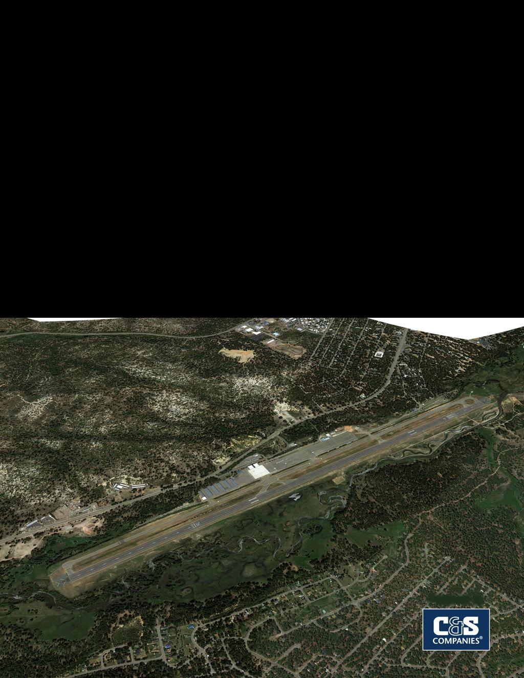
3 Existing Conditions Airport Setting Lake Tahoe Airport is a public use airport that lies within the southernmost boundaries of the City of South Lake Tahoe, CA. The Airport covers 348 acres and has one runway (Runway 18-36). The Airport is located on the eastern edge of El Dorado County in Northeastern California on the Nevada border. The City of South Lake is accessible from U.S. Route 50 from both the California and Nevada sides as it transits the City from north to south. The Airport s elevation is 6,269 feet above Mean Sea Level (MSL). The Airport is owned and operated by the City of South Lake Tahoe. The Airport Manager, responsible for oversight of the Airport and its day-to-day operations is hired by the City Manager, and is supported by full-time airport operations staff that primarily focus on the maintenance of the airport infrastructure (e.g., airfield and terminal). Airport Property Line Source: USGS Topographic Maps, Freel Creek, Echo Lake, Emerald Bay and South Lake Tahoe Quadrangles The Airport is classified as providing service to General Aviation (GA) aircraft; however, the City reserves the right to retain commercial service as discussed. FAA Federal Aviation Regulations (FAR) Part 139 sets rules that govern the certification and operation of airports that provide scheduled passenger operations of aircraft with more than nine seats and unscheduled passenger operations of an aircraft designed for at least 31 seats. There are 10 GA airports within a 30-nautical mile radius of Lake Tahoe Airport including six that are public use (i.e., not private). In addition, there are four commercial service airports that serve the South Lake Tahoe area; Reno/Tahoe International Airport (RNO), Sacramento International Airport (SMF), San Francisco International Airport (SFO) and Oakland International Airport (OAK). Lake Tahoe Airport Master Plan Draft Phase I Report 3


4 Existing Conditions Airport History Construction of the Airport began in 1958 by the County of El Dorado, CA, as part of the larger development of the community in preparation for the 1960 Winter Olympics. A building boom preceding the Olympics resulted in a flurry of commercial and residential development, and El Dorado County, along with the FAA, began operation of the Airport in the summer of Originally the runway measured 5,900 feet, but was extended to 8,541 feet in Both GA and commercial service operations peaked in the 1970s and early 1980s as the Airport became recognized by tourists as a convenient travel option. In 1983, the City of South Lake Tahoe purchased the airport from El Dorado County and became responsible for the management of its facilities and operations. The Airport maintained commercial service operations until Commercial operations peaked in 1978 with nearly 300,000 annual passenger enplanements. However, with airline deregulation later in that same year (1978) and restrictions adopted on the use of jet aircraft at the Airport those operations began to decrease. In 1992, the Airport s Master Plan Settlement Agreement was adopted and outlined additional limitations on aircraft noise, operations, and development on the airport property. The MPSA expired in October 2012 but certain provisions that addressed aircraft noise still apply to current operations. The Airport is currently home to GA activities and provides space for local businesses and City administrative needs. COMMERCIAL SERVICE CONCLUDED IN 2001 Notes: 1978 Airline deregulation and peak TVL enplanements 1992 Airport settlement agreement 2004 TVL Air traffic control tower closes 4
5 Existing Conditions Aviation Economic Impact The FAA published The Economic Impact of Civil Aviation on the U.S. Economy in December This report tabulates the impacts of both commercial (scheduled airline) and GA activity in each state and states that 5.2 percent (or $1.3 trillion) of the total U.S. Gross Domestic Product (GDP) can be attributed to civil aviation. According to this report, civil aviation generated 10.2 million jobs with a cumulative payroll of $394.4 Billion. Aviation represents 4.8 percent of the total GDP for California and percent of the GDP in Nevada based upon the individual state data in the report. Visitor expenditures from those utilizing the airports include $1.2 billion for GA facilities, including Lake Tahoe Airport. Aviation user taxes also generate $350 million in revenue each year in the State of California in which less than two percent is returned to support the state s Aeronautics Program. In 2007, the City prepared a study to review the potential off-airport revenues that could be generated by the Airport from a number of separate scenarios that included commercial service operations and general aviation only. The study concluded that without commercial service operations the Airport would still generate $2.8 million a year in cumulative revenue. This was based off of 18,916 annual operations that took place at the Airport in 2003 by GA aircraft only. With respect to current conditions, annual operations have increased 20 percent since 2003 to 23,540 annual operations. The Airport is an employment source for the local community with three full time staff. In addition to City staff, tenants contribute to the local job market by providing employment to over 36 employees (employee estimates provided via survey; not all tenants responded). These include: California Shock and Trauma Air Rescue (CalSTAR) Civil Air Patrol (The) Flight Deck Restaurant & Bar Renoe Tahoe Helicopters (scenic tours) Lake Tahoe Flight School Tahoe Mortgage Center Hertz Rent-a-Car The Airport is home to Mountain West Aviation, a full-service fixed-based-operator (FBO) located north of the airport terminal. Services provided by Mountain West include ramp parking and tie-downs, aircraft fueling, hangar leasing, aircraft de-icing, and sales and auto parking. Mountain West currently holds a 30-year lease with the City terminating in

6 Existing Conditions Landside Facilities Landside facilities at Lake Tahoe Airport include the following: Terminal In good condition with planned upgrades, the facility is used to serve GA activities, houses several businesses, and is used for City administration purposes including City Council chambers. Apron Approximately 80,790 square yards that is divided by use. The center and southern portions are in good to excellent condition. However, the northern portion adjacent to the FBO and used primarily for its services is in poor condition. There are 127 tie-downs available. Aircraft hangars Consists of a hangar complex (48 aircraft hangars and 7 storage areas; all in good condition), FBO Mountain West Aviation s facilities include an approximately 2,300-square-foot structure in fair condition. a maintenance/storage hangar (poor to fair condition), and a private aircraft storage hangar that is in good to fair condition. In addition, there are several support facilities including a fuel facility (with AvGas and Jet-A fuel), a joint ARFF and maintenance equipment storage facility, and vehicle parking areas. There are 154 parking spaces available in the main lot in front of the terminal. Although the southern portion of this lot was recently rehabilitated the northern portion and exit is in poor condition. There is an additional parking lot in poor condition operated by the FBO and used for long-term parking. Terminal Landside Facilities Not to scale Sources: Base map information like Roads, Streams, etc. are from Esri Base Map online service, Airport Property Line (APL) from C&S CAD data 6
7 Existing Conditions Airside Facilities Airside facilities at Lake Tahoe Airport include the following: Runway The Airport has one runway, designated 18-36, that has a physical length of 8,541 feet (both ends have displaced thresholds: Runway 18 is displaced 800 feet, while Runway 36 is displaced 2, feet, respectively) and is 100 feet wide, with a north-south orientation. Taxiways The taxiway system at the Airport consists of a full parallel taxiway (Taxiway A) and eight connecting taxiway segments, two of which are high speed exits. All taxiways are located west of the runway. Lighting Airfield lighting systems allow aircraft to use the Airport in periods of darkness and/or inclement weather. At Lake Tahoe Airport these include; Medium Intensity Runway Lights (MIRL) for Runway and Medium Intensity Taxiway Lighting (MITL) on all taxiways. Marking/Signage Airfield marking and signage are properly displayed at the Airport providing pilots with directional awareness to navigate the airfield. Navigational aids The navigations aids at the Airport include Precision Approach Path Indicators (PAPIs) on Runway 18, Runway End Identifier Lights (REILs) located at the threshold of Runway 36, three wind cones, segmented circle, rotating beacon and a Medium Intensity Approach Lighting System (MALSF) located on the approach end of Runway Airport Terminal BLAST PAD B REILs A 2033 DISPLACED THRESHOLD D F E F WIND CONE WIND CONE WITH SEGMENTED CIRCLE G H H PAPI ASOS WIND CONE 50 A J 800 DISPLACED THRESHOLD BLAST PAD K MALSF ROTATING BEACON LOCALIZER ANTENNA 7
8 Existing Conditions Financial Performance General aviation airports often require investment by the owning organization in order to remain financially viable. Communities view this investment as a sound economic development decision because of the direct and indirect economic impacts that aviation triggers. The Master Plan does not include a detailed economic study. However, the study team has examined the revenue and expenses associated with the Airport for use in capital improvement program planning purposes later in the study process. Information was provided by the airport manager based upon data tabulated in the City s accounting system. The City of South Lake Tahoe tracks revenue and expenses by those associated with administrative activities, the terminal building, and the airfield. Revenue is generated through a variety of sources including rents paid by tenants (e.g., office space in the terminal building, aircraft hangar storage space, and airfield lease hold tenants), landing fees paid by pilots using the facility and other sources. Revenues collected by the City of South Lake Tahoe in 2014 are projected to be $706,979 and is shown in the chart below. The largest portion of the revenue (57 percent) comes from existing rents. A transfer from the City General Fund into the airport account has been required over the last several years. The City has reduced this transfer over the last four years significantly through aggressive fiscal management and expense reductions. In Fiscal Year 2014, this transfer was $351,972 as shown in the chart below. Expenses associated with the Airport include such items as personnel (salaries, benefits, etc.), utilities, maintenance, capital projects, etc. The total expenses incurred in 2014 are $1,063,726. It is recommended that the City engage a qualified firm to conduct a detailed economic impact study in response to numerous comments received during the public meetings. Category 2014 Revenue Percentage of Total Revenue Rents $603, % Vending Machines $ % Utility/Phone Reimbursements $15, % Landing Fees $57, % Late Fees $ Fuel Flow Fees $29, % Interest/Dividend Revenue $ % Subtotal $706, Operating Transfers (General Fund) $351, % Total Revenue $1,058, Source: City of South Lake Tahoe. AIRPORT REVENUES 8
9 Critical Aircraft and FAA Design Standards Critical Aircraft The selection of appropriate FAA airport design criteria is based on the critical aircraft that utilizes the airport. The FAA defines this as the most demanding aircraft that performs or is projected to perform at least 500 annual operations at the facility. In order to determine the critical aircraft for Lake Tahoe Airport, operational data and landing fee reports were reviewed. The following table provides a summary of the based and transient aircraft fleet mix (excluding helicopters) that commonly operates at the Airport. AIRCRAFT CHARACTERISTICS Aircraft Type MTOW Approach Approach Design Wingspan Speed Category Group Cessna 172 SE 2, A I Cessna 182 SE 3, A I Piper 34 Seneca SE 4, A I Cirrus SR22 SE 3, A I Cessna 210 SE 4, A I Lake SE 3, A I Bellanca T 250 SE 3, A I Piper 31 Cheyenne TE 9, B I Beechcraft Bonanza SE 3, A I Piper PA 46 Malibu Meridian SE 4, A I Pilatus PC 6 SE 6, A II Piper PA 31T Cheyenne TP 9, B II Beech Super King Air 200 TP 12, B II Beechcraft 90 King Air TP 10, B II Cessna 525A Citation J 12, B II Cessna 560 Citation V J 16, B II Cessna 650 Citation 3/6/7 J 30, B II Dassault Falcon 2000 J 28, B II IAI 1124 Westwind J 23, C I Canadair Challenger 600 J 43, C II Gulfstream G400 J 73, C II Gulfstream V J 90, C III Source: Lake Tahoe Airport, FlightAware, FlightWise, and C&S Engineers, Inc. 9
10 Critical Aircraft and FAA Design Standards Existing Conditions Critical Aircraft The selection of appropriate FAA airport design criteria is based on the critical aircraft that utilizes the airport under existing conditions. This is defined by the FAA as the most demanding aircraft that performs at least 500 annual operations at the facility. In order to determine the critical aircraft for Lake Tahoe Airport, FlightWise data and landing fee reports were reviewed. These reports provide information as it relates to the type of aircraft operating at the airport and number of operations. Based on this information, a composite of B-II aircraft meets the FAA-defined threshold and is therefore selected as the existing critical family of aircraft. In order to address specific FAA design standards the Dassault Falcon 2000 was chosen as the representative aircraft.. Aircraft Characteristics The Dassault Falcon 2000 has a wingspan of feet, a tail height of feet, a Maximum Takeoff Weight (MTOW) of 28,660 pounds, and an approach speed of 107 knots. Thus, for design purposes, the Dassault Falcon 2000 is categorized as a member of Aircraft Approach Category B (approach speeds 91 knots or more but less than 121 knots) and Airplane Design Group II (aircraft with wingspans up to 49 feet but less than 79 feet and tail heights up to 20 feet but less than 30 feet). Dassault Falcon 2000 Existing Critical Aircraft Photograph Source: www. dassaultfalcon.com Design Standards An evaluation of the Airport considering FAA design standards for an ARC B-II shows that the following standards/guidelines are not met: Runway Object Free Areas (ROFA) extend 300 feet beyond the runway end and have a width of 500 feet under B-II design standards. The ROFA should be clear of above ground objects unless required by function. A tree line located along the Upper Truckee River is located within the ROFA that extends beyond the approach end of Runway 36. Runway Safety Areas (RSA) extend 300 feet beyond the runway end and have a width of 150 feet under B-II design standards. The RSA that extends beyond the approach end of Runway 36 extends off airport property, though the City has an easement over this property. Runway Protection Zones (RPZ) extend 1,000 feet have an inner-width of 500 feet and an outerwidth of 700 feet under B-II design standards. The departure RPZ begins 200 feet from the runway end and the approach RPZ begins 200 feet from the displaced threshold. The departure RPZ extends off airport property on Runway 18, though the City does has an easement over a portion of this area. The approach RPZ extends off airport property slightly (0.19 acres) on the approach end of Runway

11 Critical Aircraft and FAA Design Standards Future Conditions Critical Aircraft The selection of appropriate FAA airport design criteria for future conditions is based on the critical aircraft that is forecasted to utilize the airport. This is defined by the FAA as the most demanding aircraft that performs at least 500 annual operations at the facility. In order to determine the critical aircraft for future conditions at Lake Tahoe Airport, FlightWise data and landing fee reports were reviewed. Although the number of aircraft operations by the Gulfstream V does not currently meet the FAA-defined threshold for selection of a design aircraft (exceeding 500 annual itinerant operations), based on projected demand and aircraft operational trends at Lake Tahoe Airport the Gulfstream V was selected as the future design aircraft. Aircraft Characteristics The Gulfstream V has a wingspan of feet, a tail height of feet, a MTOW of 90,500 pounds, and an approach speed of 140 knots. Thus, for design purposes, the Gulfstream V is categorized as a member of Aircraft Approach Category C (approach speeds 121 knots or more but less than 141 knots) and Airplane Design Group III (aircraft with wingspans up to 79 feet but less than 118 feet and tail heights up to 30 feet but less than 45 feet). G-V (Future Critical Aircraft Photograph Source: v n691rc Design Standards An evaluation of the Airport considering FAA design standards for an ARC C-III shows that there are a number of standards/guidelines that are not met. The following highlights the most critical: The Gulfstream V has a maximum certified takeoff weight below 150,000 lbs. Runway widths to meet ARC C-III design standards should be at 100 feet which Runway currently complies with. Minimum separation distances between the runway centerline and taxiway centerline to meet ARC C-III design standards is 400 ft. The current separation distance varies from 285 feet to feet. Runway Safety Areas (RSA) extend 1,000 feet beyond the runway end and have a width of 500 feet under C-III design standards. The RSA extends into the Upper Truckee River on both ends of Runway making the RSA non-compliant to FAA design standards. Runway Object Free Areas (ROFA) extend 1,000 feet beyond the runway end and have a width of 800 feet under C-III design standards. The ROFA extends into the Upper Truckee River on both ends of Runway making the RSA non-compliant to FAA design standards. The parallel taxiway (Taxiway A) would be located within the ROFA. Runway Protection Zones (RPZ) extend 1,700 feet have an inner-width of 500 feet and an outerwidth of 1,010 feet under C-III design standards. The departure RPZ begins 200 feet from the runway end and the approach RPZ begins 200 feet from the displaced threshold. The departure and approach RPZs extend off airport property on both runway ends. 11

12 Aviation Demand Forecast Historical Aviation Activity An aircraft operation is a measure of activity that is defined as either a takeoff or a landing; a takeoff and a landing represent two operations. Aircraft activity at Lake Tahoe Airport has declined since a peak was reached in 1978 of 63,881 annual operations. The change in the availability of air service at the Airport contributed largely to this shift in activity. General aviation activity makes up nearly all of the current flights to and from the Airport and has remained mostly steady over the last several years at about 23,000 annual operations. 80,000 60,000 40,000 20,000 Annual Operations: Lake Tahoe Airport 63, Calendar Year Existing Mix of Activity Itinerant 79% Mix of Activity: 2012 Lake Tahoe Airport Military 2% Local 19% Operations are categorized as local (originating at the airport by an aircraft based there) or itinerant operations by visiting aircraft. The region s popularity as a destination for tourism is reflected in the mix of activity with most (79 percent) of the operations attributed to itinerant aircraft see the figure to the left. This is generally opposite of the experience of similar airports nationally. Forecast Methodology Several methodologies outlined in FAA Advisory Circular B, Airport Master Plans, were evaluated in consideration of the information available and nature of the airport. A trend analysis and extrapolation methodology combined with regression analysis was selected for the forecast development. This approach considers key historical data that may affect future growth opportunities within South Lake Tahoe s leisure and tourism industry while addressing the unique and sometimes volatile nature of the aviation market. Currently, over 75 percent of all traffic at the Airport is associated with itinerant traffic or traffic originating elsewhere with Lake Tahoe Airport as a destination, thus supporting the selection of this methodology. 12
13 $700 $600 $500 $400 $300 $200 $100 Visitor Spending Millions of Dollars Annually El Dorado County Trend: 1.7% Average year over year $ Calendar Year Draft Aviation Demand Forecast Based on the improving economy, continued marketing efforts of the South Lake Tahoe community, and the forecasted growth of the aviation industry, the number of operations at Lake Tahoe Airport is projected to increase by approximately 17 percent by It is anticipated that growth will continue but at a slower rate through the mid- and long-term planning periods after the initial surge subsides. A closer examination of the aircraft operations forecast reveals the growth will be led primarily by strong itinerant traffic and air taxi activity. It is believed that the Lake Tahoe market will parallel the broader national general aviation market. The strength of the market will be found in its ability to attract larger general aviation aircraft to support visitors to the areas many winter activities and summer eco-tourism. Visitor Economic Activity For the purpose of this forecast, the period from 2000 to July 2013 was considered. From 2000 through 2010 occupancy declined every year when measured on a year-over-year basis. Declines ranged from a low of 2.1 percent in 2001 to 12.5 percent in The average decline in rooms rented during the period was slightly more than seven percent. While the information gathered did not speculate about the contributors to this decline, it is likely driven by several variables including increased competition from similar destination markets and a general downturn in both economies of California and Nevada as well as the nation as a whole. The period 2010 through mid-2013 reflects a different trend, however. Although 2011 again saw a decline in occupancy of 4.2 percent, the period showed a positive trend averaging a nearly 4.5-percent annual growth. It is believed this growth is stimulated by improving economic conditions as well as a continued, revitalized marketing effort on the part of the community and the State of California. 32,000 30,000 28,000 26,000 24,000 22,000 Draft Annual Operations Forecast Lake Tahoe Airport 20, Calendar Year 13

14 Facility Requirements The following summarizes recommendations based Terminal on future demand and the ability of existing The General Aviation Terminal at the Airport facilities to meet that demand. Facility requirements provides adequate space for forecasted demand. are based on the criteria for the critical aircraft (the Should more space be needed for aeronautical G-V) and its Aircraft Design Group and Aircraft activities, reallocating space in the terminal for these Approach Category. activities should be undertaken. Airfield Support Facilities Many of the airfield components would need to Supporting infrastructure at the Airport is adequate be upgraded in order to meet C-III standards. This to meet forecasted demand. However, airport would include: recirculation should be considered so that airport traffic is not required to make left-hand turns onto Relocation of runway or taxiway to meet the public roadway. In addition, only a portion of separation standards the parking lot was recently rehabilitated. The Widening Runway shoulders to 20 feet remaining pavement is in poor condition. Clearing and grading of RSAs Removal of obstacles within ROFAs Acquisition or easement over land located Parking Lot within approach and departure RPZs Relocation of aircraft tie-downs Adjustments to airfield signage and markings Aircraft Parking Although existing capacity of aircraft storage is adequate, apron rehabilitation on the north apron should be undertaken to preserve the utility of this space. Additionally, hangar storage should be considered for transient aircraft. Management Initiatives North Apron There are a number of management initiatives that should be considered to improve efficiency and compliance of airport activity. These include: -Minimum Standards revision and enforcement -Airport Business Plan -Rates and Charges Analysis -Airport Rules and Regulations revision -Part 139 Certification Surrender These will be further explored through the development and analysis of the alternatives. 14
15 Environmental Considerations The objective of conducting an environmental overview as part of the master planning process is two-fold: a. to describe the existing environmental conditions, and b. to identify environmentally sensitive areas that may require special management, conservation and/or preservation during the planning, design and construction of proposed airport development projects. Based on a preliminary review of the airport property and surrounding area the following environmental resources were identified as having the potential for impacts as they relate to future airport development: Air Quality/Climate TRPA has established air quality thresholds for carbon monoxide, ozone, visibility (regional and sub-regional), nitrate deposition, and odor. Noise/Land Use Although the existing 65 db CNEL noise contour does not extend off airport property, proposed projects that could potentially alter aircraft operations, aircraft fleet mix, or change runway use would be subject to further review. The airport currently has an Airport Land Use Compatibility Plan (ALUCP) in place and will be updated after the Master Plan. Fish/Wildlife & Plants Six federal, state, or locally protected species have been identified with a high potential of occurring on or around the Airport. Floodplains According to the Federal Emergency Management Agency (FEMA), the western and southern portion of the airport property falls within a 100-year flood zone. Wetlands/SEZ Wetland and riparian habitats that are supported by the Upper Truckee River are potentially jurisdictional and proposed development within them would require coordination with U.S. Army Corps of Engineers (USACE). Areas located along the Upper Truckee River have also been designated as within a stream environment zone (SEZ). SEZs provide natural treatment, storage, and conveyance of surface runoff and development in these areas reduces their potential to filter sediment and nutrients, and also reduces the amount of surface runoff they can effectively treat. Historical Resources Although no currently listed cultural or historic places were documented on airport property, further cultural analysis would be required as part of the project-specific environmental compliance. Water Quality Proposed development at the Airport could potentially impact water quality due to erosion or contaminant exposure from construction. Updates and adherence to existing permits and best-management-practices (BMPs) would be required. Detailed impacts and mitigation as they relate to specific development projects would be addressed during the preparation of the appropriate National Environmental Policy Act (NEPA), California Environmental Quality Act (CEQA) and Tahoe Regional Planning Agency (TRPA) required documents. The Environmental Overview Map, shown on the following page, depicts various aspects of the Airport property and its vicinity including environmental features discussed in the previous sections. 15
16 Hold for Environment Overview Map 16
17 Sustainability Integrating Sustainability The City and its airport tenants have already integrated sustainability across many of their operations. For example, the City installed a CNG station in the vehicle parking lot; has adopted a limited mowing routine that reduces air emissions; currently recycles paper, cans and other materials at the Airport; and practices material reuse in construction projects. The City and the Airport also played a significant role in the Upper Truckee River restoration program by narrowing the dimensions of the runway by 50 ft. in 2008 and allowing for portions of the recently vacated land to be redesignated as SEZ. Based on feedback from the community and input provided by the City and its users, a number of sustainability goals have been identified for this Airport Master Plan: The FBO encourages transportation to and from the Airport by bicycle. Their fleet of bicycles (pictured) is available to patrons free of charge. Economic Viability Operational Efficiency Natural Resource Conservation Social Responsibility Goal 1: Become as self sufficient as possible Sub Goal 1a: Increase revenue Sub Goal 1b: Reduce resource consumption Sub Goal 1c: Minimize maintenance and operation costs Goal 2: Enhance aircraft capabilities Goal 3: Increase connectivity with the transportation system including alternative transportation Goal 4: Increase efficiency of Airport management / operation Goal 5: Protect wetlands and lake clarity Goal 6: Minimize air quality and noise impacts Goal 7: Ensure land use compatibility Sub Goal 7a: Minimize noise impacts (see Goal 6) Goal 8: Provide community benefits These will be considered in the evaluation of alternatives and identification of specific initiatives in the next chapter of the Airport Master Plan. Preliminary opportunities are discussed in the report for consideration. 17
18 Stakeholder Feedback Public Outreach In order to solicit feedback from the community two public meetings and one direct presentation to the City Council have been completed to date. The public meetings included a presentation, question and answer session, and an open public workshop. The meetings were advertised in the local paper, radio, and television. s and postcards were also sent to those that live in close proximity to the Airport and aircraft overflight zones or those that signed up to receive updates on the plans process. Key information was gathered from the meetings and primarily focused on the following themes: Master plan process Is the master plan addressing the right things? Airport benefit The Airport can be considered a vital regional asset for transportation and emergency services. How does the Airport benefit the community? Economic benefit/strain Is the Airport being fully utilized and are there better uses for the airport property? What is the return on investment from the Airport and can revenues be increased to offset costs to the taxpayer? Airport closure Should airport closure or reduction in size be considered? Environmental impacts What are the environmental impacts of the airport? Can noise impacts be reduced to the community? Commercial service Is the return of commercial service flights desired by the community and is a subsidy to the airlines needed? Safety What can be done to improve the safety of the airport? Key Issues Key issues can be described as airport development issues that the master plan process will review and attempt to resolve. Key issues and needs, summarized below, were identified through an inventory of existing conditions, environmental overview, and coordination with airport management, users and other stakeholders: Future ARC C-III design standards Taxiway configuration and nomenclature Density altitude Existing navigational aids Obstructions to navigable airspace Runway 36 instrument approach procedure visibility minimums Development constraints due to terrain No self-service fuel available for aircraft Existing vehicle parking lot pavement Airport entrance road location and signage Highest and best use of available apron space. Lack of airport perimeter road Airport Traffic Control Tower (ATCT) Large aircraft storage FBO maintenance services Environmental considerations Community perception of Airport Commercial service operations Economic cost to operate the Airport 18
Master Plan Report Lake Tahoe Airport Airport Master Plan Final Executive Summary
 Master Plan Report Lake Tahoe Airport Airport Master Plan Final Executive Summary City of South Lake Tahoe South Lake Tahoe, CA May 2017 FAA AIP #3 06 0249 033 Lake Tahoe Airport Master Plan Draft Phase
Lake Tahoe Airport Master Plan Public Meeting March 16, 2015
 Lake Tahoe Airport Master Plan Public Meeting March 16, 2015 What is an Airport Master Plan? a comprehensive study of an airport [that] usually describes the short, medium, and long term development plans
Lake Tahoe Airport Master Plan
 Lake Tahoe Airport Master Plan City Council Briefing October 20, 2015 What is an Airport Master Plan? a comprehensive study of an airport [that] usually describes the short, medium, and long term development
Executive Summary. MASTER PLAN UPDATE Fort Collins-Loveland Municipal Airport
 Executive Summary MASTER PLAN UPDATE Fort Collins-Loveland Municipal Airport As a general aviation and commercial service airport, Fort Collins- Loveland Municipal Airport serves as an important niche
CHAPTER 1 EXECUTIVE SUMMARY
 CHAPTER 1 EXECUTIVE SUMMARY 1 1 EXECUTIVE SUMMARY INTRODUCTION William R. Fairchild International Airport (CLM) is located approximately three miles west of the city of Port Angeles, Washington. The airport
Table of Contents. Overview Objectives Key Issues Process...1-3
 Table of Contents Chapter One Introduction Overview...1-1 Objectives...1-1 Key Issues...1-2 Process...1-3 Chapter Two Inventory of Existing Conditions Airport Setting...2-1 Locale...2-1 Airport Surroundings...2-5
Tallahassee International Airport Master Plan. Technical Advisory Committee Meeting #2 October 19, 2016
 Tallahassee International Airport Master Plan Technical Advisory Committee Meeting #2 October 19, 2016 Agenda Welcome / Introductions Master Plan Process and Project Status Forecast of Aviation Demand
DRAFT FINAL REPORT AIRPORT MASTER PLAN. Rifle Garfield County Airport Revised May 15, 2014
 DRAFT FINAL REPORT AIRPORT MASTER PLAN Rifle Garfield County Airport Revised May 15, 2014 As required by Paragraph 425.B(4) of FAA Order 5100.38C, Airport Improvement Program (AIP) Handbook: The preparation
MONTEREY REGIONAL AIRPORT MASTER PLAN TOPICAL QUESTIONS FROM THE PLANNING ADVISORY COMMITTEE AND TOPICAL RESPONSES
 MONTEREY REGIONAL AIRPORT MASTER PLAN TOPICAL QUESTIONS FROM THE PLANNING ADVISORY COMMITTEE AND TOPICAL RESPONSES Recurring topics emerged in some of the comments and questions raised by members of the
DRAFT MASTER PLAN UPDATE
 DRAFT MASTER PLAN UPDATE CHAPTER VI: AIRPORT LAYOUT PLAN NARRATIVE DRAFT REPORT APRIL 2017 PREPARED BY: Table of Contents WESTCHESTER COUNTY AIRPORT 6 AIRPORT LAYOUT PLAN NARRATIVE REPORT... 6-1 6.1 AGIS
Airport Master Plan. Brookings Regional Airport. Runway Runway 17-35
 Runway 17-35 Airport Master Plan Runway 12-30 Brookings Regional Airport Table of Contents Table of Contents Chapter 1: Master Plan Goals... 1-1 1.1. Introduction... 1 1.2. Objective 1 Identify improvements
1.0 Project Background Mission Statement and Goals Objectives of this Sustainable Master Plan
 TABLE OF CONTENTS CHAPTER 1 INTRODUCTION 10 Project Background 1-1 11 Mission Statement and Goals 1-1 12 Objectives of this Sustainable Master Plan 1-2 CHAPTER 2 INVENTORY 20 Airport Background 2-1 201
AIRSIDE CAPACITY AND FACILITY REQUIREMENTS
 AIRSIDE CAPACITY AND FACILITY REQUIREMENTS This Section investigates the capacity of the airport, its ability to meet current demand, and the facilities required to meet forecasted needs as established
CHAPTER 1: INTRODUCTION
 CHAPTER 1: INTRODUCTION Purpose and Scope The information presented in this report represents the study findings for the 2016 Ronan Airport Master Plan prepared for the City of Ronan and Lake County, the
Document prepared by MnDOT Office of Aeronautics and HNTB Corporation. MINNESOTA GO STATE AVIATION SYSTEM PLAN
 LAST UPDATE JULY 2013 Acknowledgements The preparation of this document was financed in part by a grant from the Federal Aviation Administration (Project No: 3-27-0000-07-10), with the financial support
Appendix D Project Newsletters. Tacoma Narrows Airport. Master Plan Update
 Appendix D Project Newsletters Tacoma Narrows Airport Master Plan Update This appendix contains the newsletters distributed throughout the project. These newsletters provided updates and information on
Dallas Executive Airport Town Hall Meeting April 3, 2014
 Dallas Executive Airport Town Hall Meeting April 3, 2014 Background 1,040 acre general aviation facility owned and operated by the City of Dallas 150 based aircraft including business jets and helicopters,
FACILITY REQUIREMENTS SUMMARY OF KEY ISSUES OVERVIEW
 FACILITY REQUIREMENTS SUMMARY OF KEY ISSUES OVERVIEW This summary is intended to provide a brief overview of the key issues associated with conformance to FAA standards at Methow Valley State Airport.
Addendum - Airport Development Alternatives (Chapter 6)
") Bowers Field Addendum - Airport Development Alternatives (Chapter 6) This addendum to the Airport Development Alternatives chapter includes the preferred airside development alternative and the preliminary
Bowers Field Addendum - Airport Development Alternatives (Chapter 6) This addendum to the Airport Development Alternatives chapter includes the preferred airside development alternative and the preliminary
STUDY WORK GROUP MEETING No. 3. November 29, 2016
 STUDY WORK GROUP MEETING No. 3 November 29, 2016 Agenda Welcome and introductions Update project schedule Brief overview of previous SWG meeting Update on aviation forecasts Introduction to airfield demand/capacity
CHAPTER 3 ALTERNATIVES CONSIDERED
 CHAPTER 3 ALTERNATIVES CONSIDERED 3.0 ALTERNATIVES The 2010 Stevensville Airport Master Plan contained five (5) airside development options designed to meet projected demands. Each of the options from
Merritt Island Airport
 TABLE OF CONTENTS CHAPTER 1 INTRODUCTION... 1-1 INTRODUCTION AND PROJECT OVERVIEW... 1-1 General Guidelines... 1-1 Prior Planning Documentation... 1-2 Key Issues... 1-2 Goals and Objectives... 1-2 Regulatory
General Aviation Master Plan Update
 Peter O. Knight Airport Public Meeting #2 Peter O. Knight Airport Agenda Welcome and Introductions HCAA System of Airports Purpose of Public Meetings Master Plan Status Update Next Steps Q & A 2 Our System
CHAPTER 1 BACKGROUND AND PROPOSED ACTION
 CHAPTER 1 BACKGROUND AND PROPOSED ACTION 1.0 INTRODUCTION An Environmental Assessment (EA) evaluates the effects of a proposed Federal action on the surrounding environment and is prepared in compliance
STUDY OVERVIEW MASTER PLAN GOALS AND OBJECTIVES
 INTRODUCTION An Airport Master Plan provides an evalua on of the airport s avia on demand and an overview of the systema c airport development that will best meet those demands. The Master Plan establishes
TABLE OF CONTENTS. Washington Aviation System Plan Update July 2017 i
 TABLE OF CONTENTS Chapter 1 Overview... 1-1 1.1 Background... 1-1 1.2 Overview of 2015 WASP... 1-1 1.2.1 Aviation System Performance... 1-2 1.3 Prior WSDOT Aviation Planning Studies... 1-3 1.3.1 2009 Long-Term
Westover Metropolitan Airport Master Plan Update
 Westover Metropolitan Airport Master Plan Update June 2008 INTRODUCTION Westover Metropolitan Airport (CEF) comprises the civilian portion of a joint-use facility located in Chicopee, Massachusetts. The
Safety, Infrastructure, and Tenant Improvement Project. Public Hearing Informational Brochure February 26, 2013
 New York State Department of Transportation Safety, Infrastructure, and Tenant Improvement Project Public Hearing Informational Brochure February 26, 2013 This DEIS/Draft EA evaluates the potential impacts
Milton. PeterPrinceAirportislocatedinSantaRosaCounty, approximatelythreemileseastofmilton.
 Milton GeneralAviationAirport PeterPrinceAirportislocatedinSantaRosaCounty, approximatelythreemileseastofmilton. Existing Facilities Peter Prince Airport is served by one runway, Runway 18/36, 3,700 feet
Prepared By: Mead & Hunt, Inc Port Lansing Road Lansing, MI 48906
 Master Plan The preparation of this document was financed in part through a planning grant from the Federal Aviation Administration (FAA) as provided under Section 505 of the Airport and Airway Improvement
Airport Master Plan Open House Front Range Airport February 23, 2017
 Airport Master Plan Open House Front Range Airport February 23, 2017 MASTER PLAN PROCESS AND OVERVIEW MASTER PLAN ELEMENTS The Master Plan is a 20-year plan to understand the needs of current and future
FORECASTING FUTURE ACTIVITY
 EXECUTIVE SUMMARY The Eagle County Regional Airport (EGE) is known as a gateway into the heart of the Colorado Rocky Mountains, providing access to some of the nation s top ski resort towns (Vail, Beaver
Airport Master Plan Update June 15, 2017
 Airport Master Plan Update June 15, 2017 www.harveyfield.com The Master Plan is a 20-year plan to understand the needs of current and future users of the Airport. This is important to ensure that safe
5. Facility Requirements
 5. Facility Requirements The purpose of this chapter is to compare existing airfield and adjacent landside facilities with the Airport operations and aircraft forecasts developed in the previous chapter
TABLE OF CONTENTS. General Study Objectives Public Involvement Issues to Be Resolved
 TABLE OF CONTENTS Description Page Number LIST OF ACRONYMS... a CHAPTER ONE INTRODUCTION General... 1-1 Study Objectives... 1-1 Public Involvement... 1-2 Issues to Be Resolved... 1-2 CHAPTER TWO EXISTING
New Opportunities PUBLIC WORKSHOP. Venice Municipal. Bringing g the pieces together
 Bringing g the PUBLIC WORKSHOP Venice Municipal Airport New Opportunities Presented for Venice City Council & Citizens of Venice September 25, 2009 Slide 1 Bringing g the Welcome & Introductions May 12th
ERIE INTERNATIONAL AIRPORT MASTER PLAN TABLE OF CONTENTS
 EXECUTIVE SUMMARY ERIE INTERNATIONAL AIRPORT MASTER PLAN TABLE OF CONTENTS PAGE NO. CHAPTER 1-INTRODUCTION... 1-1 1.01 General...1-1 1.02 Purpose and Scope of Study...1-1 1.03 The Planning Process...1-2
Airport Master Plan for. Brown Field Municipal Airport PAC Meeting #3
 Airport Master Plan for Brown Field Municipal Airport PAC Meeting #3 Public Meeting #1 > 8/24/17 from 5:30 to 8:00 pm > 41 attendees signed-in > Comments: > EAA area > Environmental constraints > Focus
Hartford-Brainard Airport Potential Runway Closure White Paper
 Hartford-Brainard Airport Potential Runway 11-29 Closure White Paper June 2012 In recent years there has been discussion regarding the necessity of Runway 11-29 to the Hartford- Brainard Airport (HFD)
Airport Master Plan Update June 15, 2017
 Airport Master Plan Update June 15, 2017 www.harveyfield.com The Master Plan is a 20-year plan to understand the needs of current and future users of the Airport. This is important to ensure that safe
Yolo County Airport. ALP Narrative Report. April Prepared by Mead & Hunt, Inc. for the County of Yolo, California
 Yolo County Airport ALP Narrative Report April 2016 Prepared by Mead & Hunt, Inc. for the County of Yolo, California Yolo County Airport ALP Narrative Report Prepared for the County of Yolo Mindi Nunes,
Punta Gorda Airport Master Plan Update
 Punta Gorda Airport Master Plan Update Draft Executive Summary Prepared for: The Charlotte County Airport Authority January 2018 Charlotte County Airport Authority James Herston, Chair Robert D. Hancik,
Chapter 2 FINDINGS & CONCLUSIONS
 Chapter 2 FINDINGS & CONCLUSIONS 2.01 GENERAL Dutchess County acquired the airport facility in 1947 by deed from the War Assets Administration. Following the acquisition, several individuals who pursued
Runway Length Analysis Prescott Municipal Airport
 APPENDIX 2 Runway Length Analysis Prescott Municipal Airport May 11, 2009 Version 2 (draft) Table of Contents Introduction... 1-1 Section 1 Purpose & Need... 1-2 Section 2 Design Standards...1-3 Section
Agenda: SASP SAC Meeting 3
 Agenda: SASP SAC Meeting 3 Date: 04/12/18 Public Involvement Plan Update Defining the System Recommended Classifications Discussion Break Review current system Outreach what we heard Proposed changes Classification
15 Precision Approach Path Indicator 33 None RSA 150 feet wide by 300 feet long 150 feet wide by 300 feet long
 The first (AMP) was completed in 1984 and updated in 2000. The current FAA approved Airport Layout Plan (ALP) is dated November 9, 2001. The FAA suggests updating the AMP every five year in accordance
Chapter 9 - AIRPORT SYSTEM DESIGN
 Chapter 9 - AIRPORT SYSTEM DESIGN 9.01 GENERAL This chapter discusses the development program for Dutchess County Airport to the year 2020. This airport system design is based upon the airport's existing
Airport Master Plan for Montgomery-Gibbs Executive Airport PAC Meeting #3
 Airport Master Plan for Montgomery-Gibbs Executive Airport PAC Meeting #3 Agenda > Introductions > Public Meetings Overview > Working Paper 3 - Facility Requirements > Working Paper 4 - Environmental Baseline
B GEORGIA INFRASTRUCTURE REPORT CARD AVIATION RECOMMENDATIONS DEFINITION OF THE ISSUE. Plan and Fund for the Future:
 2014 GEORGIA INFRASTRUCTURE REPORT CARD B + RECOMMENDATIONS Plan and Fund for the Future: While the system continues to enjoy excess capacity and increased accessibility it still needs continued focus
MASTER PLAN CONCEPT 1 DRAFT
 The Airport Master Plan Update for Dallas Executive Airport has included the development of aviation demand forecasts, an assessment of future facility needs, and the evaluation of airport development
ArcadiaMunicipalAirportislocatedonthesoutheast sideofarcadia,southofstateroute70,westofstate Route31,andisaccessiblefrom AirportRoad.
 Arcadia GeneralAviationAirport ArcadiaMunicipalAirportislocatedonthesoutheast sideofarcadia,southofstateroute70,westofstate Route31,andisaccessiblefrom AirportRoad.Arcadia islocatedapproximately30milesnortheastoftheport
Technical Memorandum. Synopsis. Steve Carrillo, PE. Bryan Oscarson/Carmen Au Lindgren, PE. April 3, 2018 (Revised)
") Appendix D Orange County/John Wayne Airport (JWA) General Aviation Improvement Program (GAIP) Based Aircraft Parking Capacity Analysis and General Aviation Constrained Forecasts Technical Memorandum To:
Appendix D Orange County/John Wayne Airport (JWA) General Aviation Improvement Program (GAIP) Based Aircraft Parking Capacity Analysis and General Aviation Constrained Forecasts Technical Memorandum To:
CHAPTER 3 AIRPORT FACILITY REQUIREMENTS
 CHAPTER 3 AIRPORT FACILITY REQUIREMENTS 3.1 Introduction The existing runway and taxiway system at Skyhaven Airport provides more than adequate operational capacity to accommodate future peak hour and
CHAPTER 5 - FACILITY REQUIREMENTS
 CHAPTER 5 - FACILITY REQUIREMENTS This chapter identifies the requirements for airfield and landside facilities to accommodate the forecast demand level. Facility requirements have been developed for the
Table of Contents. Master Plan March 2014 TOC i Spokane International Airport
 Table of Contents Page Chapter 1 Inventory 1. Introduction... 1 1 1.1 Community Profile... 1 2 1.1.1 Location and Setting... 1 1 1.1.2 Climate... 1 2 1.1.3 Socioeconomic Conditions... 1 5 1.1.4 Area Land
Draft Concept Alternatives Analysis for the Inaugural Airport Program September 2005
 Section 10 Preferred Inaugural Airport Concept 10.0 Introduction The Preferred Inaugural Airport Concept for SSA was developed by adding the preferred support/ancillary facilities selected in Section 9
JOHNSTON COUNTY AIRPORT AUTHORITY
 JOHNSTON COUNTY AIRPORT AUTHORITY REQUEST FOR QUALIFICATIONS FOR AIRPORT PLANNING SERVICES For JOHNSTON REGIONAL AIRPORT (JNX) 3149 Swift Creek Rd. Smithfield, NC 27577 PHIL LANIER AIRPORT DIRECTOR (919)
Chapter Three AIRPORT FACILITY REQUIREMENTS/ALTERNATIVES
 Chapter Three AIRPORT FACILITY REQUIREMENTS/ALTERNATIVES Airport Layout Plan Report In this chapter, existing components of the Airport are evaluated so that the capacities of the overall system are identified.
Burke Lakefront Airport (BKL) Master Plan Update
 Master Plan Update") Burke Lakefront Airport () Master Plan Update Public Workshop August 2, 2007 City of Cleveland Department of Port Control (DPC) City of Cleveland DPC Studies Currently In Progress Market Assessment & Feasibility
Burke Lakefront Airport () Master Plan Update Public Workshop August 2, 2007 City of Cleveland Department of Port Control (DPC) City of Cleveland DPC Studies Currently In Progress Market Assessment & Feasibility
Appendix C AIRPORT LAYOUT PLANS
 Appendix C AIRPORT LAYOUT PLANS Appendix C AIRPORT LAYOUT PLANS Airport Master Plan Santa Barbara Airport As part of this Airport Master Plan, the Federal Aviation Administration (FAA) requires the development
Technical Advisory Committee Meeting February 29, 2016
 Technical Advisory Committee Meeting February 29, 2016 Meeting Agenda Introduction Recap of Planning Process Project Status Goals and Objectives Forecasts of Aviation Demand Overview of Facility Requirements
Preliminary Findings of Proposed Alternative
 Preliminary Findings of Proposed Alternative The attached drawing provides a schematic layout of the proposed alternative that will be discussed on July 27, 2010. A full report will follow and should be
STAFF REPORT. Airport Land Use Plan Consistency Review: Santa Barbara Airport Master Plan. MEETING DATE: November 19, 2015 AGENDA ITEM: 7D
 STAFF REPORT SUBJECT: Airport Land Use Plan Consistency Review: Santa Barbara Airport Master Plan MEETING DATE: AGENDA ITEM: 7D STAFF CONTACT: Peter Imhof, Andrew Orfila RECOMMENDATION: Adopt findings
1.1.3 Taxiways. Figure 1-15: Taxiway Data. DRAFT Inventory TYPICAL PAVEMENT CROSS-SECTION LIGHTING TYPE LENGTH (FEET) WIDTH (FEET) LIGHTING CONDITION
 WIDTH (FEET) LIGHTING CONDITION") 1.1.3 Taxiways EWN has an extensive network of taxiways and taxilanes connecting the terminal, air cargo, and general aviation areas with the runways as listed in Figure 1-15. A 50-foot wide parallel taxiway
1.1.3 Taxiways EWN has an extensive network of taxiways and taxilanes connecting the terminal, air cargo, and general aviation areas with the runways as listed in Figure 1-15. A 50-foot wide parallel taxiway
Why are the underground fuel tanks being removed and replaced with above ground tanks?
 AIRPORT/CITIZEN FAQ This list of Frequently Asked Questions (FAQs) with responses are provided to share information related to airport topics with the Citizens of Georgetown. The questions / responses
Lopez Island Airport Master Plan Update. Public Meeting June 15, 2017
 Lopez Island Airport Master Plan Update Public Meeting June 15, 2017 Master Plan Update Team Reid Middleton/Everett, WA Shannon Kinsella, Project Manager Melania Haagsma, Project Engineer Mead & Hunt/Tulsa,
Chapter Seven COST ESTIMATES AND FUNDING A. GENERAL
 Chapter Seven COST ESTIMATES AND FUNDING A. GENERAL This chapter delineates the recommended 2005 2024 Sussex County Airport Capital Improvement Program (CIP). It further identifies probable construction
Public Information Meeting. September 2015
 W ki P O & T / Working Papers One & Two/ Public Information Meeting September 2015 Agenda Introductions and Opening Comments Project Overview, Process, and Schedule Review Materials from Working Papers
Preferred Alternative Summary
 Tacoma Narrows Airport Master Plan Update Preferred Alternative Summary The Preferred Alternative represents Pierce County s vision for the long-term development of the Tacoma Narrows Airport. This Alternative
Introduction DRAFT March 9, 2017
 Chapter Overview The City of Redmond (City) initiated an update to the Airport Master Plan ( Plan ) to assess the facility and service needs of the Redmond Municipal Airport ( the Airport ) throughout
Airport Master Plan Update
 Duttchessss Countty Airrporrtt Masstterr Plan Updatte Airport Master Plan Update Final Report Dutchess County Airport Town of Wappingers, New York C&S Engineers, Inc. 499 Col. Eileen Collins Blvd. Syracuse,
Aviation Planning in Maine and Our Region. Stacie Haskell Aviation Coordinator & Study Manager Maine Department of Transportation April 27, 2011
 Aviation Planning in Maine and Our Region Stacie Haskell Aviation Coordinator & Study Manager Maine Department of Transportation April 27, 2011 Overview The National Aviation System Maine s Economic Dependence
Chapter 4.0 Alternatives Analysis
 Chapter 4.0 Alternatives Analysis Chapter 1 accumulated the baseline of existing airport data, Chapter 2 presented the outlook for the future in terms of operational activity, Chapter 3 defined the facilities
The offers operators increased capacity while taking advantage of existing airport infrastructure. aero quarterly qtr_03 10
 The 747 8 offers operators increased capacity while taking advantage of existing airport infrastructure. 14 aero quarterly qtr_03 10 Operating the 747 8 at Existing Airports Today s major airports are
Draft Concept Alternatives Analysis for the Inaugural Airport Program September 2005
 Draft Concept Alternatives Analysis for the Inaugural Airport Program September 2005 Section 3 - Refinement of the Ultimate Airfield Concept Using the Base Concept identified in Section 2, IDOT re-examined
PLU Airport Master Plan. Master Plan Advisory Committee (MPAC) Meeting #4 March 19, 2018
 Meeting #4 March 19, 2018") PLU Airport Master Plan Master Plan Advisory Committee (MPAC) Meeting #4 March 19, 2018 Meeting Agenda 1. Master Plan Status [5 Minutes] 2. Preferred Forecasts [15 Minutes] 3. Runway Length Options [45
PLU Airport Master Plan Master Plan Advisory Committee (MPAC) Meeting #4 March 19, 2018 Meeting Agenda 1. Master Plan Status [5 Minutes] 2. Preferred Forecasts [15 Minutes] 3. Runway Length Options [45
CHAPTER 3 FACILITY REQUIREMENTS
 CHAPTER 3 FACILITY REQUIREMENTS 3.1 INTRODUCTION To properly plan for the future requirements of Newport News/Williamsburg International Airport, it is necessary to translate the forecasts of aviation
AIRPORT MASTER PLAN UPDATE
 AIRPORT MASTER PLAN UPDATE PENSACOLA INTERNATIONAL AIRPORT Technical Advisory Committee Meeting #2 June 20, 2017 Agenda» Introduction» Facility Requirements Airside Terminal Landside General Aviation Cargo
Appendix B Ultimate Airport Capacity and Delay Simulation Modeling Analysis
 Appendix B ULTIMATE AIRPORT CAPACITY & DELAY SIMULATION MODELING ANALYSIS B TABLE OF CONTENTS EXHIBITS TABLES B.1 Introduction... 1 B.2 Simulation Modeling Assumption and Methodology... 4 B.2.1 Runway
Source: Chippewa Valley Regional Airport ASOS, Period of Record
 Chapter 1 Inventory Runway wind coverage is the percentage of time a runway can be used without exceeding allowable crosswind velocities. Allowable crosswind velocities vary depending on aircraft size
BELFAST MUNICIPAL AIRPORT OVERVIEW
 BELFAST MUNICIPAL AIRPORT OVERVIEW LOCATION AND HISTORY Belfast Municipal Airport (Federal Aviation Administration (FAA) airport code BST, International Civil Aviation Organization airport code KBST, FAA
Study Committee Meeting. September 2015
 W ki P T / Working Paper Two/ Study Committee Meeting September 2015 Agenda Introductions and Opening Comments Project Overview, Process, and Schedule Review Materials from Working Paper Two Comments,
For Airport Environmental Services. Date Released: August 27, 2018 Deadline for Submission: 5:00pm, September 17, 2018
 COUNTY OF INYO REQUEST FOR QUALIFICATIONS For Airport Environmental Services Date Released: August 27, 2018 Deadline for Submission: 5:00pm, September 17, 2018 County of Inyo Public Works Department P.O.
CHAPTER D Capacity Analysis and Facility Requirements INTRODUCTION
 CHAPTER D Capacity Analysis and Facility Requirements INTRODUCTION The capacity of an airfield is primarily a function of the major aircraft operating surfaces that compose the facility and the configuration
Airport Master Plan. Rapid City Regional Airport. October 2015 FAA Submittal
 Airport Master Plan Rapid City Regional Airport October 2015 FAA Submittal Rapid City Regional Airport Master Plan Update Table of Contents Executive Summary... i Scope & Timeline... i Forecasts... i Preferred
Chapter Six ALP Drawings. Tacoma Narrows Airport. Master Plan Update
 Chapter Six ALP Drawings Master Plan Update The master planning process for the (Airport) has evolved through efforts in the previous chapters to analyze future aviation demand, establish airside and landside
Background Data: Blue Canyon Airport and Environs
 5 Background Data: and Environs INTRODUCTION serves as an important emergency landing field amid mountainous terrain. The airport has existed on the site since the 1930s or 40s. The facility was operated
3 INTRODUCTION. Chapter Three Facility Requirements. Facility Requirements PEAKING CHARACTERISTICS
 Chapter Three Facility Requirements 3 INTRODUCTION This chapter identifies the long-range airfield and terminal area facilities needed to satisfy the 20-year forecast of aviation demand at Monett Municipal
Chapter 8.0 Implementation Plan
 Chapter 8.0 Implementation Plan 8.1 Introduction This chapter is the culmination of the analytical work accomplished in the previous chapters. The result is a prioritized list of the essential projects.
Finance and Implementation
 5 Finance and Implementation IMPLEMENTATION The previous chapters have presented discussions and plans for development of the airfield, terminal, and building areas at Sonoma County Airport. This chapter
FORT LAUDERDALE-HOLLYWOOD INTERNATIONAL AIRPORT ENVIRONMENTAL IMPACT STATEMENT DRAFT
 D.3 RUNWAY LENGTH ANALYSIS Appendix D Purpose and Need THIS PAGE INTENTIONALLY LEFT BLANK Appendix D Purpose and Need APPENDIX D.3 AIRFIELD GEOMETRIC REQUIREMENTS This information provided in this appendix
SouthwestFloridaInternational Airport
 SouthwestFloridaInternational Airport SouthwestFloridaInternationalAirportislocatedinLee CountyalongtheGulfCoastofSouthFlorida,tenmiles southeastofthefortmyerscentralbusinessdistrict. Theprimaryhighwayaccesstotheairportfrom
According to FAA Advisory Circular 150/5060-5, Airport Capacity and Delay, the elements that affect airfield capacity include:
 4.1 INTRODUCTION The previous chapters have described the existing facilities and provided planning guidelines as well as a forecast of demand for aviation activity at North Perry Airport. The demand/capacity
C > Capacity Analysis and Facility Requirements
 Buchanan Field Buchanan Field Airport Master Planning Program C. CAPACITY ANALYSIS & FACILITY REQUIREMENTS C > Capacity Analysis and Facility Requirements INTRODUCTION. The capacity of an airfield is primarily
COMMERCIAL AND GENERAL AVIATION
 Existing Facilities Daytona Beach International Airport is served by a number of airside and landside facilities. The airport has three asphalt runways: Runway 07L/25R (10,500 feet long by 150 feet wide),
Input Efforts Online survey of tenants and users Focus group meetings with Tenants and users Agencies and stakeholders General Aviation Pilot
 Input Efforts Online survey of tenants and users Focus group meetings with Tenants and users Agencies and stakeholders General Aviation Pilot community Airport Advisory Board meetings Elected Officials
FRENCH VALLEY AIRPORT (F70) Sky Canyon Dr. Murrieta, CA. Phone: Riverside FAA FSDO Complaint Line: (951)
 Sky Canyon Dr. Murrieta, CA. Phone: Riverside FAA FSDO Complaint Line: (951)") FRENCH VALLEY AIRPORT (F70) 37600 Sky Canyon Dr. Murrieta, CA Phone: 951-600-7297 Riverside FAA FSDO Complaint Line: (951) 276-6701 Visit the F70 website for additional information regarding the airport
FRENCH VALLEY AIRPORT (F70) 37600 Sky Canyon Dr. Murrieta, CA Phone: 951-600-7297 Riverside FAA FSDO Complaint Line: (951) 276-6701 Visit the F70 website for additional information regarding the airport
HILLSBORO AIRPORT MASTER PLAN UPDATE Planning Advisory Committee Meeting 1
 HILLSBORO AIRPORT MASTER PLAN UPDATE Planning Advisory Committee Meeting 1 Feb. 27, 2017 HILLSBORO AIRPORT MASTER PLAN UPDATE Planning Advisory Committee Welcome Curtis Robinhold, Port of Portland 1 HILLSBORO
AIRPORT MASTER PLAN. Newport State Airport. Draft. (Colonel Robert F. Wood Airpark) THE Louis Berger Group, INC. Prepared for: Prepared by:
 THE Louis Berger Group, INC. Prepared for: Prepared by:") Draft AIRPORT MASTER PLAN Newport State Airport () Prepared for: 2000 Post Road Warwick, Rhode Island 02886-1533 THE Louis Berger Group, INC. 20 Corporate Woods Boulevard Albany, New York 12211-2370 Prepared
Draft AIRPORT MASTER PLAN Newport State Airport () Prepared for: 2000 Post Road Warwick, Rhode Island 02886-1533 THE Louis Berger Group, INC. 20 Corporate Woods Boulevard Albany, New York 12211-2370 Prepared
Chapter 5. Facility Requirements
 Chapter 5 Facility Requirements Chapter 5 Facility Requirements INTRODUCTION The Baseline Forecast was used to determine facility requirements. Chapter 4 produced a forecast of traffic volumes expected