SOUTHEASTERN BOX ELDER COUNTY 2017 ACTIVE TRANSPORTATION CONCEPT PLAN DRAFT
|
|
|
- Daisy Blair
- 5 years ago
- Views:
Transcription

1 SOUTHEASTERN BOX ELDER COUNTY 2017 ACTIVE TRANSPORTATION CONCEPT PLAN

 Willard City Project Partners Bear River Association of Governments Bear River Health Department Bear River Migratory Bird Refuge Bear River Water Conservancy District Bike")

2 SIGNATURE PAGE The following communities have participated in this trail planning process and approve the Southeastern Box Elder County Active Transportation Concept Plan. ACKNOWLEDGEMENTS The Southeastern Box Elder County Active Transportation Concept Plan was developed by the following communities for residents, visitors, and future generations. Contributing Communities Jeff Scott, Commission Chair Box Elder County Tyler Vincent, Mayor Brigham City Karen Cronin, Mayor Perry City Date Date Box Elder County Brigham City Perry City South Willard (unincorporated) Willard City Project Partners Bear River Association of Governments Bear River Health Department Bear River Migratory Bird Refuge Bear River Water Conservancy District Bike Utah Pine View Water Systems Uinta-Wasatch-Cache National Forest Utah Department of Transportation, Region 1 Utah Division of Water Resources Utah Division of Wildlife Resources Utah Forestry, Fire & State Lands Utah Transit Authority Wasatch Front Regional Council Weber Pathways Willard Bay State Park Southeastern Box Elder County Active Transportation Concept Plan 2017 Date Box Elder County Planning 1 South Main St Brigham City, Utah (435) Ken Braegger, Mayor Willard City Date Corridor Plan prepared by: i

3 TABLE OF CONTENTS Executive Summary III 1. Introduction... Vision... Goals & Objectives... Benefits of Active Transportation Regional Setting & Background... Southeastern Box Elder County... Existing Conditions... Opportunities & Constraints Proposed Active Transportation Corridors... Regional Map... Historic Orchard Pathway... FrontRunner Trail... Wetland Trail... Bonneville Shoreline Trail... Lower Bench Trail... Fire Break Trail... Eagle Mountain Trail... Brigham City Section... Perry Section... Willard Section... South Willard Section Active Transportation Facility Design Guide Trailheads... Surface Types... Slope... Crossings... Landscaping... Signage... American with Disabilities Act Compliance... Envrionmental Considerations Implementation... Partnerships & Coordination... Marketing & Tourism... Access and Easements... Potential Costs... Project Funding & Sources Corridor Regulatory & Management Administration Rules & Regulations Maintenance & Repairs Box Elder County Trails Committee References Appendice ii
4 EXECUTIVE SUMMARY III

5 Orchard Pathway Willard section 1 INTRODUCTION Vision Provide Information on Eduction, Health, A regional non-motorized active transportation system connecting the and Recreation communities of southeastern Box Elder County and adjacent counties safe opportunities for recreation, education, public health, alternative transportation, economic development, and resource sharing. Department, and Brigham Recreation Department Brigham City, and Box Elder School Districts Goals and Objectives Provide Local and Regional Connectivity recreation groups, and schools sites system through development standards Provide Recreational Amenities for with a safe and efficient trail system Residents and Visitors counties cycling Historic parks, natural areas, and public lands Provide Connections to Economic Centers and Tourism Destinations Create Partnership with Public and Private Land Owners, Agencies, and Organizations 1


6 Benefits of Active Transportation Active transportation any form of human-powered transportation, such as biking or walking is growing in popularity across the U.S. as more than Investing in active transportation can help create a safer, more connected, and accessible pedestrian network that yields economic, social, and environmental benefits. Economic Vitality & Tourism Active transportation can contribute to a healthy economy through direct impacts for users such as reduction in travel costs to more indirect impacts, such as growth in bicycle related businesses. Increasing the amount of active transportation infrastructure can benefit the local economy through: Growth in active transportation related industries (e.g. bike shops, bike and walking tour companies, rental shops) 1 Attracting tourist spending through restaurants, lodging and special events 2, 3 4 Providing access to employment 2 Providing more compact communities resulting in lower infrastructure and service costs 3 Improved livability and community attractiveness 4, 5 Figure 1-1. Businesses, such as Valerie Taylor Gallery along U.S. in Willard stand to gain from the economic activity active transportation can generate. Recreation Active transportation can support a range of activities from walking to bird They provide citizens and visitors with designated areas to recreate, and routes to recreation destinations, including municipal parks, Willard Bay State Park and the Uinta-Wasatch-Cache National Forest. Trails also act as a destination for visitors by taking them through community attractions and connecting them to different amenities. Multi-Modal Transportation & Air Quality Residents and visitors can recreate, exercise, travel or commute in attractive, safe, accessible and low or no-cost places along active transportation corridors. Corridors can also be incorporated into existing transportation networks to connect with public transit and parking. A diversity of travel options can also reduce the number of vehicles on the road thus reduces vehicle emissions. A reduction in vehicle emissions can lead to improved community health. 2 Figure 1-2. Bear River Migratory Bird Refuge located west of Brigham City is a regional recreation destination for hunting, bird watching, and hiking. Health & Wellness Active transportation can help people of all ages incorporate exercise into their daily routine by connecting them with places they want or need to go. Other health benefits include: Improved personal health and increased life expectancy 2, 7 Lower health care costs and enhance community wellbeing 8 Provides opportunity for families, friends, and neighbors to interact and * See appendix X for health statistics on Box Elder County. Community Engagement & Identity Active transportation corridors are community space where neighbors can meet, children can play, and community groups can gather for events. They provide a means to create strong, vibrant communities. They can also be the site of a fun run, bicycle race, or a location to celebrate a community s cultural heritage and geological history. Environment Active transportation corridors can be green corridors that benefit the living and physical environment as well. They can help protect natural lands needed for wildlife habitat and plants, and wetlands for improving water and air storage and filtration. 1 Travel Oregon, The economic significance of cycling on Oregon scenic bikeways, 2014 June 2015, uploads/2015/06/orscenicbikewaystudy2014.pdf 2 Victoria Transport Policy Institute, Evaluating active transport benefits and costs, September 2016, Community Cycles, Dollars and jobs: The Value of Boulder s Bicycle Related Economy, Results of Community Cycles Economic Survey, November 2011, 3 Sonoma County Transportation Authority, Economic impacts of walking & bicycling in Sonoma County, January 2013, default/files/suekelly/economic_impacts_of_walking_and_bicycling_in_sonoma_county_january_2013_scta.pdf 4 National Park Service, Economic Impacts of Protecting Rivers, Trails, and Greenway Corridors, 1995, 5 Ryan Snyder Associates, LLC, The economic value of active transportation, 2005, 6 Geoffery Godbey, Outdoor Recreation, Health, and Wellness: Understanding, and Enhancing the Relationship, outdoor-recreation-health-and-wellness-understanding-and-enhancing 7 U.S. Department of Health & Human Services, 2008 physical activity guidelines for Americans, 2008, 8 Guijing Want, Caroline Macera, Barbara Schudder-Soucie, Tom Schmid, Michael Pratt, & David Buchner, A Cost-Benefit Analysis of Physical Activity Using Bike/Pedestrian Trails, 2


7 2 REGIONAL SETTING & BACKGROUND Southeastern Box Elder County Southeastern Box Elder County is located in Northern Utah along the Wasatch Front metropolitan region, 45 minutes north of Salt Lake City. The region is confined by the Wasatch Mountains to the east and Willard Bay and the Great Salt Lake to the west. In between is a narrow strip of land that is beginning to grow significantly. The area is also known for the adjacent Bear River Bird Refuge for seasonal hunting and bird watching, Willard Bay State Park, a camping, boating and fishing haven, and historic fruit orchards and roadside produce stands. hunting grounds before the Mormon pioneers settled the region in the mid- 19th century. Communities established themselves on agriculture; grazing sheep and cattle, fruit orchards and row crops. With the transcontinental railroad meeting at Promontory, just northwest of the region, southeastern Box Elder County sustained itself exporting crops and produce. Today, the region has found regional economic success from manufacturing industries including, Orbital ATK Inc., an aerospace manufacturer, and Nucor Steel along with growth from Ogden and the rapidly expanding Wasatch Front. Communities of Southeastern Box Elder County Southeastern Box Elder County is made up of Brigham City, Perry, Willard and unincorporated South Willard. Established in 1853, Brigham City has a population of 18,752 people. 1 It is the largest city and the commercial hub for the region. Perry, just south of Brigham City has approximately 4,700 residents. The town s population had doubled in size since 2000 with additional housing developments in progress. Willard, located 3 miles north of the Weber County line, is home to roughly 1,800 people. The town is adjacent to Willard Bay State Park and the newly constructed Willard Creek Nature Park 1 and Debris Basin. Unincorporated South Willard located between Willard and Weber County, contains approximately 1,800 residents. It is a small expanding bedroom community before entering Weber County. Active Transportation Planning History As population has increased in the last fifteen years, local leaders have expressed a desire to improve local transportation conditions and the livability of southeastern Box Elder County for residents and visitors. Active transportation planning began in 2013 when Willard, Perry, Brigham City and Box Elder County officials, residents and staff began planning for a pathway along the historic Utah-Idaho Rail Corridor, locally referred to as the Bamberger Railroad. The corridor, once an electric rail service, connected Ogden to Logan, and eventually to Preston, Idaho. The railway was used primarily for passenger and freight services, moving fruits and other goods in and out of the region. The railway was abandoned and cleared of tracks in 1947 with sections of the corridor now owned by the towns and County. Figure 2-1. Utah-Idaho electric rail car from the early 1900s. To support the development of the rail corridor and other active transportation corridors in the region, Box Elder County applied for the National Park Service (NPS) Rivers, Trails, and Conservation Assistance Program (RTCA) program and received a planning assistance grant to draft an active transportation planning 3
, Box Elder County, Brigham City, Perry, and Willard has taken place to develop this")

8 document in Since receiving funding, a coordinated effort between NPS RTCA, Bear River Association of Governments (BRAG), Box Elder County, Brigham City, Perry, and Willard has taken place to develop this document. Existing Condition The following section covers the current conditions in southeastern Box Elder County for land use, roads, public transit, and active transportation along with in the region. A detailed inventory of existing conditions can be found in appendix X. Land Use Southeastern Box Elder County is a low density region primarily made up of Agriculture Residential Commercial Manufacturing/ Industrial PERRY BRIGHAM CITY WILLARD SOUTH WILLARD residential and agricultural uses (see figure 2-2). The region has seen commercial businesses develop along Main St and along 1100 South in Brigham City. Brigham City also has a thriving manufacturing and industrial area on the westside of town. Perry and Willard are bedroom communities with little commercial and manufacturing activities. Roads When the Mormons settled the region in the mid-1800s, they based their towns on the Plat of Zion. The Plat organized communities around a system of gridded streets. Most towns have grown following the Plat. This has helped the region develop a strong network of north-south and east-west arterial and collector roads, including 750 North in Willard and 1100 South and Forest Street in Brigham city (see figure 2-3). Interstate 15 provides regional north-south movement while U.S., another north-south arterial, provides local movement through each of the communities. 3/4 mile paratransit service area UTA Bus Route SOUTH WILLARD UTA Bus Stop Proposed UTA FrontRunner Stop Interstate Railroad PERRY BRIGHAM CITY WILLARD N 1/2 1 2 Miles N 0 1/2 1 2 Miles Figure 2-2. Land uses of southeastern Box Elder County. Figure 2-3. Public transportation routes and roads of southeastern Box Elder County. 4

9 Public Transportation With a small population, the region is only serviced by one bus route along the U.S. corridor looping in Brigham City. The route is operated by Utah Transit Authority. Figure 5 displays the route and stops along with a 3/4 mile buffer for paratransit services. The 3/4 mile buffer represents the approximate maximum distance paratransit needs to meet for American with Disabilities Act (ADA) compliance. UTA FrontRunner commuter rail service is planned along the Union Pacific rail corridor. The line has potential stops in Willard, Perry and Brigham City. Right-ofway analysis has been completed along the corridor and a local sales tax option for corridor preservation is being collected. There is no completion date for the rail service at this time. Active Transportation Similar to other small-town regions, southeastern Box Elder County has a limited active transportation network with isolated routes throughout the region. Brigham City has several bicycle lanes and a multi-use sidewalk connecting the Bird Refuge to Reese Pioneer Park. Willard has completed 1.5 miles of paved shared-use path and designated shoulder along the Historic Orchard Pathway as well as a recently built shared-use path circling the Willard Creek Nature Park & Retention Basin. Perry has funded 1.75 miles of the Historic Orchard Pathway from Davis Street to 1500 South and Commerce Way set to be completed by Nearby public lands, including the Bear River Migratory Bird Refuge offers loop single track trails. Willard Bay State Park has portions of its dike designated as trail (Pelican beach parking lot to Willard Bay South Marina). Brigham Face Wildlife Management Area and the Uinta-Wasatch-Cache National Forest have several miles of unofficial single track and unimproved road or jeep trail along the bench and up the canyons. Opportunities Tourism & Recreation Willard Bay State Park, Golden Spike National Monument, Bear River Migratory Bird Refuge, Brigham Face Wildlife Management Area, and Uinta-Wasatch- Cache National Forest are all located within or near southeastern Box Elder County. These recreation areas provide an opportunity to connect existing tourism and recreation amenities to communities. Utility & Railroad Corridors Water, sewer, electric, gas and other utilities often run through public rightof-ways or easements. These utility corridors can provide opportunities for trail development. Incorporating utilities with active transportation paths are an efficient way to combine uses and save on costs associated with path development. Railroad corridors are another excellent way to combine utilities and paths to reduce costs. They have established easements and uninterrupted linear corridors ideal for paths. Figure 2-4. Rail and utility corridors such as the Union Pacific railway are a great linear corridor for active transportation routes because of established easements. Existing Development Patterns Southeastern Box Elder County is largely undeveloped providing ample opportunities to plan corridors that will serve future land use and developments. The amount of undeveloped land also lends itself to determining high value conservation and historical areas. Constraints Auto-Dependent Land Use & Transportation Following WWII, transportation shifted towards the automobile, which is limited safe and efficient means of alternative or active transportation. For example, high-speed arterial roadways including, U.S. and 1100 South in Brigham City, provide limited crossings. Where crosswalks exist it is difficult for pedestrians and cyclists to move through the intersection safely. Land Ownership needed for active transportation corridors. Population Growth & Future Development Located on the north end of the 120-mile Wasatch Front metropolitan region, southeastern Box Elder County (Brigham City, Perry, Willard, South Willard) is projected to double to nearly 50,000 residents by 2050 (Utah Foundation, 2014). If trail easements and right-of-ways are not established early, residential developments could limit the regional active transportation network. 5

. The following table breaks down the rating system. Table 3-1.")
10 3 PROPOSED ACTIVE TRANSPORTATION CORRIDORS Southeastern Box Elder County Regional Active Transportation Concept Plan proposes to add over 112 miles of corridors connecting schools, businesses, churches, civic buildings, parks and public lands for residents and visitors. Corridor Use: Recommended activity for the trail, including pedestrian, Level of Difficulty: Easy, medium and hard represent the three levels of difficulty based on surface materials (tread) and slope (steepness). The following table breaks down the rating system. Table 3-1. Summary of Design Standards for Recreation Trails Access Routes Easy Moderate Difficult Paved: asphalt, concrete, Compacted The following section highlights the regional system and individual corridor Varies, but needs to Surface (tread) boardwalk with crushed rock or sections. Each corridor section will include the following: be firm and stable ramped or level compacted earth entry Corridor Description: A brief summary highlighting the corridor. Clear width (minimum) 48 in. 36 in. 28 in. Sustained running slope Corridor Type: The type of corridor recommended for each section. 5% 8.3% 12.5% (steepness) Maximum grade 8.3% 10%-14% 20% Shared-use path: paved or nonpaved corridor where more than one active transportation use can be found. Shared-use paths are separated from other For a maximum distance 30 ft. 50 ft. 50 ft. of transportation activities, such as roads. Cross slope (maximum) 2% 3% 5% Bicycle lane: a designated area for bicyclist to follow adjacent to roads. They Passing space interval 200 ft 300 ft 400 ft can be designated by stripes or barriers. Rest area interval 400 ft 900 ft 1,200 ft Small level changes 0.5 in. maximum 1 in. maximum 3 in. maximum Single track: a narrow natural surface trail typically 2-4 feet in width. *Note: No more than 20% of total length of the access route shall exceed the maximum sustained running grade **Note: Cross slop may not exceed 3% in maximum grade segments, or 5% in maximum grade segments on Unimproved Road or Jeep Trail: gravel or any other non-paved road material difficult access trails. typically 6-12 feet in width. ***Note: The measurement of a maximum grade and cross slope should be made over a 24 measurement interval to correspond to the footing of a wheelchair operating in that environment. Other: a broad classification of corridors that includes the following Source: Recreation Access Advisory Committee, Recommendations for Accessibility Guidelines: Recreation Facilities and Outdoor Developed Areas, U.S. Architectural and Transportation Barriers Compliance Board, July designations: Other, Sidewalk: a concrete path ranging from 5 to 10 feet depending on its Corridor Connections: Highlights important places the trail passes through location. or connects to. Other, Shoulder: a paved or unpaved Approximate Length: This figure represents the relative length of the section of road between the travel corridor and not an exact length. Length of the trail is subject to change as the lane and the edge of the road. corridor is further designed and developed. Shoulders are located on the right side of the road. Landowners are listed to help identify entities to contact for future land Other, Sharrow: a travel lane marking for bicyclist to follow and to alert Responsible Entities: A list of recommended agencies that would be motorist that bicyclist may be responsible for planning, designing, managing or maintaining sections of the present. Motorist yield to bicyclist. corridor. Figure 3-1. A pedestrian traveling along a shoulder. Figure 3-2. A bicyclist travel along a narrow shoulder. Existing Condition: Provides a brief list of completed or funded sections of the corridor, if they exist. Proposed Timeline: An estimated timeline to follow to plan, design and build the corridor. 6

11 Figure 3-3. Existing and proposed active transportation corridor for southeastern Box Elder County. To Weber County Rail Trail To To Weber County Bonneville Shoreline Trail Miles N 8300 SOUTH SOUTH WILLARD Willard Bay State Park Utah State Sovereign Lands Uinta-Wasatch-Cache National Forest School Trust Lands Municipal Parks 6850 SOUTH Brigham Face Wildlife Management Area Uinta-Wasatch-Cache National Forest Bear River Migratory Bird Refuge Water Road Municipal Building School WILLARD Proposed FrontRunner Stop EXISTING FACILITIES & FEATURES CENTER ST Willard Bay State Park Willard Canyon or single track) Other - Unofficial (sidewalk, shoulder, sharrow, path, Other (sidewalk, shoulder, sharrow, path, or single track) 750 NORTH Unimproved Road or Jeep Trail - Unofficial Unimproved Road or Jeep Trail 1200 WEST Single Track Bike Lane Shared-Use Path White Rock PROPOSED ACTIVE TRANSPORTATION CORRIDORS


12 HISTORIC ORCHARD PATHWAY Willard Bay 8700 South North Forest St PERRY 800 West WILLARD South SOUTH WILLARD 38 BRIGHAM CITY 91 Passing through the iconic orchards and farmlands of southeastern Box Elder County, the Historic Orchard Pathway, or HOP, follows the former Central Utah- Idaho Railway north from Weber County, linking South Willard, Willard, Perry and Brigham City. RECOMMENDED CORRIDOR TYPE: Paved shared-use path (separated) Figure 3-5. Recommended dimensions for the HOP shared-use path. RECOMMENDED CORRIDOR USES: LEVEL OF DIFFICULTY: Easy CORRIDOR CONNECTIONS: Community center, civic buildings, agricultural areas, commercial and manufacturing districts, existing parks APPROXIMATE CORRIDOR LENGTH: South Willard/Brigham County: 6.0 miles Willard: 3.5 miles Perry: 5.0 miles Brigham City: 4.0 miles Brigham City connector: 3.0 Miles TOTAL: 21.5 miles RESPONSIBLE ENTITIES: Box Elder County Brigham City Perry Willard EXISTING CONDITIONS: Paved shared-use: 1.5 miles Unpaved shoulder: 2.5 miles Funded sections: 1.75 miles PROPOSED TIMELINE: To Weber County Rail Trail Figure 3-4. The HOP provides a shared-use CORRIDOR TYPES Existing Shared-Use Funded Shared-Use Proposed Shared-Use Proposed Shared-Use Connector Other Proposed and Existing Corridors Miles EXISTING FACILITIES & FEATURES Municipal Parks Federal & State Public Lands Municipal Boundaries Water Roads N Figure 3-6. Paved HOP Willard section passing through a scenic agricultural area.


13 FRONTRUNNER TRAIL The FronterRunner Trail follows the Union Pacific railway from Willard to Reese Pioneer Park in Brigham City. The corridor would connect western portions of Willard, Perry and Brigham City with few road crossings. Forest St 3000 South 750 North Figure 3-7. The FrontRunner Trail provides connection to future development and FrontRunner stops. CORRIDOR TYPES Proposed Shared-Use Other Proposed and Existing Corridors PERRY WILLARD 6850 South BRIGHAM CITY South SOUTH WILLARD Miles EXISTING FACILITIES & FEATURES Municipal Parks Federal & State Public Lands Municipal Boundaries Water Roads Proposed FrontRunner Stops 0.5 N RECOMMENDED CORRIDOR TYPE: Paved shared-use path RECOMMENDED CORRIDOR USES: Pedestrian, bicycle Figure 3-8. Recommended dimensions for FrontRunner shared-use path. LEVEL OF DIFFICULTY: Easy CORRIDOR CONNECTIONS: FrontRunner stops, future development APPROXIMATE CORRIDOR LENGTH: Willard: 4.0 miles Perry: 3.0 miles Brigham City: 2.0 miles TOTAL: 9.0 miles RESPONSIBLE ENTITIES: Box Elder County Brigham City Perry Utah Transit Authority Union Pacific Willard PROPOSED TIMELINE: Figure 3-9. The FrontRunner Trail would follow the County s right-of-way along the current Union Pacific railway. 9


 Brigham City Perry City Utah Forestry, Fire & State Lands Willard City Willard Bay State Park EXISTING CONDITIONS: Unimproved")
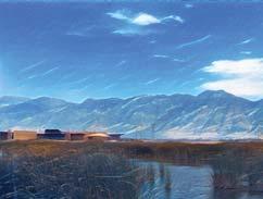
14 WETLAND TRAIL 8700 South 8700 South PERRY Forest St 750 North 13 BRIGHAM CITY 1100 South WILLARD SOUTH WILLARD 91 The Wetland Trail travels through Willard Bay State Park along the dike and a section of paved road. The trail leaves the park and follows an unimproved frontage road adjacent to farmlands and wetlands eventually connecting to the Bear River Migratory Bird Refuge (U.S. Fish and Wildlife Service). RECOMMENDED CORRIDOR TYPE: Other Unimproved sharrow (gravel) RECOMMENDED CORRIDOR USES: Figure Recommended dimensions for the unimproved sharrow Wetland Trail. LEVEL OF DIFFICULTY: Medium CORRIDOR CONNECTIONS: Willard Bay State Park, Bear River Migratory Bird Refuge APPROXIMATE CORRIDOR LENGTH: Willard Bay State Park: 6.0 miles Private lands: 4.5 miles Bear River Migratory Bird Refuge: 2.0 miles TOTAL: 12.5 miles RESPONSIBLE ENTITIES: Bear River Migratory Bird Refuge (USFWS) Brigham City Perry City Utah Forestry, Fire & State Lands Willard City Willard Bay State Park EXISTING CONDITIONS: Unimproved road: 4.5 miles PROPOSED TIMELINE: Figure The Wetland Trail connects Willard Bay State Park to the Bear River Migratory Bird Refuge. CORRIDOR TYPES Other* - Unofficial Proposed Other* Other Proposed and Existing Corridors *unimproved sharrow Miles EXISTING FACILITIES & FEATURES Municipal Parks Federal & State Public Lands Municipal Boundaries Water Roads 0.5 N Figure The Wetland Trail would follow an unimproved frontage road on the western side of I-15.


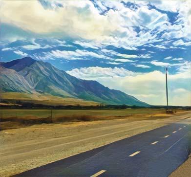
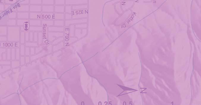
15 BONNEVILLE SHORELINE TRAIL 13 Forest St 38 BRIGHAM CITY The Bonneville Shoreline Trail (BST) follows the terraces formed by ancient Lake Bonneville 15,000-10,000 years ago. The trail connects to public lands and provides stunning views of the Great Salt Lake and Willard Bay as well as the entire southeastern Box Elder County area. RECOMMENDED CORRIDOR TYPE: Single Track PERRY 8700 South 750 North WILLARD 1100 South SOUTH WILLARD 91 To Weber County Bonneville Shoreline Trail Figure Recommended dimensions for the BST. RECOMMENDED CORRIDOR USES: Pedestrian, bicycle LEVEL OF DIFFICULTY: Medium to Difficult CORRIDOR CONNECTIONS: Uinta-Wasatch-Cache National Forest, Brigham Face Wildlife Management Area, Box Elder Canyon, Weber County BST APPROXIMATE CORRIDOR LENGTH: Private lands: 12.0 miles Utah Division of Wildlife Resources: 8.0 miles Uinta-Wasatch-Cache National Forest: 1.0 miles TOTAL: 21.0 miles RESPONSIBLE ENTITIES: Box Elder County Perry City Utah Division of Wildlife Resources Uinta-Wasatch-Cache National Forest Willard EXISTING CONDITIONS: Unofficial Single Track: 13.5 miles PROPOSED TIMELINE: Figure The Bonneville Shoreline Trail provides communities with access to public lands and stunning views of the Great Salt Lake and Willard Bay. CORRIDOR TYPES Single Track - Unofficial Proposed Single Track Other Proposed and Existing Corridors Miles EXISTING FACILITIES & FEATURES Municipal Parks Federal & State Public Lands Municipal Boundaries Water Roads N Figure Looking out over Willard Bay from the Bonneville Shoreline Trail. 11


16 LOWER BENCH TRAIL 1100 South BRIGHAM CITY 91 The Lower Bench Trail follows existing canal right-of-ways from Highway /91 to Weber County. The trail provides access to the lower foothills created by Lake Bonneville. RECOMMENDED CORRIDOR TYPE: Unimproved Road or Jeep Trail PERRY 8700 South 750 North WILLARD SOUTH WILLARD To Weber County Figure The Lower Bench Trail follows existing canal right-of-ways, and provides residents and visitors with an accessible route along the lower foothills. CORRIDOR TYPES Unimproved Road or Jeep Trail - Unofficial Proposed Unimproved Road or Jeep Trail Other Proposed and Existing Corridors Miles N Figure Recommended dimensions for the Lower Bench Trail. RECOMMENDED CORRIDOR USES: LEVEL OF DIFFICULTY: Medium CORRIDOR CONNECTIONS: Uinta-Wasatch-Cache National Forest, Brigham Face Wildlife Management Area, Box Elder Canyon, Weber County, Perry Canyon, Willard Canyon, White Rock APPROXIMATE CORRIDOR LENGTH: Private Lands: 9.0 miles Utah Division of Wildlife Resources: 1.0 miles Uinta-Wasatch-Cache National Forest: 0.5 miles TOTAL: 10.5 miles RESPONSIBLE ENTITIES: Box Elder County Perry City Pine View Water Systems Utah Division of Wildlife Resources Uinta-Wasatch-Cache National Forest Willard City EXISTING CONDITIONS: Unimproved Road or Jeep Trail - Unofficial: 10.5 miles PROPOSED TIMELINE: EXISTING FACILITIES & FEATURES Municipal Parks Federal & State Public Lands Municipal Boundaries Water Roads Figure View down the Lower Bench trail towards Brigham Face Wildlife Management Area. 12


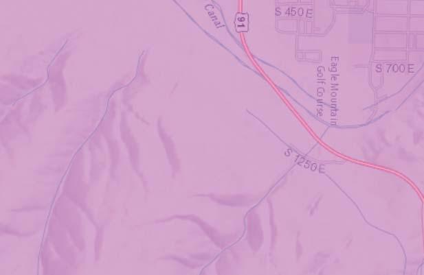
17 FIRE BREAK TRAIL BRIGHAM CITY LOWER BENCH CORRIDOR TYPES Unimproved Road or Jeep Trail - Unofficial Other Proposed and Existing Corridors PERRY 3000 South 1100 South Miles Figure The Fire Break Trail would connect Box Elder Canyon with White Rock through Brigham Face Wildlife Management Area. The Fire Break Trail follows Fire Break Road and White Rock Road through Brigham Face Wildlife Management Unit and the Uinta-Wasatch-Cache National Forest between US /91 and White Rock a prominent geologic feature between Willard and Perry Canyons. RECOMMENDED CORRIDOR TYPE: Unimproved Road or Jeep Trail 91 WHITE ROCK To Mantua N APPROXIMATE CORRIDOR LENGTH: Private lands: 1.5 miles Utah Division of Wildlife Resources: 6.5 miles Uinta-Wasatch-Cache National Forest: 1.0 miles TOTAL: 9.0 miles RESPONSIBLE ENTITIES: Box Elder County Perry City Utah Division of Wildlife Resources Uinta-Wasatch-Cache National Forest Willard City EXISTING CONDITIONS: Unimproved Road or Jeep Trail - Unofficial: 9.0 miles PROPOSED TIMELINE: EXISTING FACILITIES & FEATURES Municipal Parks Federal & State Public Lands Municipal Boundaries Water Roads Figure Recommended dimensions for the Fire Break Trail. RECOMMENDED CORRIDOR USES: LEVEL OF DIFFICULTY: Medium CORRIDOR CONNECTIONS: Uinta-Wasatch-Cache National Forest, Brigham Face Wildlife Management Area, Box Elder Canyon, Perry Canyon Figure View of the Fire Break Trail with the Bear River Migratory Bird Refuge and Promontory Mountains in the background. 13


18 EAGLE MOUNTAIN TRAIL BRIGHAM CITY 200 South 14 The Eagle Mountain Trail runs along an abandoned railroad spur along the north side of the 1100 South corridor and continues towards the mouth of Box Elder Canyon. After crossing 200 South the trail follows a utility easement on the north side of Box Elder Canyon connecting to Mantua. RECOMMENDED CORRIDOR TYPE: Shared-use path, unimproved road or jeep trail Figure Recommended dimensions for the shared-use Eagle Mountain Trail. RECOMMENDED CORRIDOR USES: Pedestrian, bicycle LEVEL OF DIFFICULTY: Easy to Medium CORRIDOR CONNECTIONS: 1100 South business district, Box Elder Canyon, Bonneville Shoreline Trail APPROXIMATE CORRIDOR LENGTH: Private lands: 3.5+ miles Utah Dept. of Transportation: 3.0 miles TOTAL: 6.5+ miles PROPOSED TIMELINE: Medical Dr Figure The Eagle Mountain Trail would connect to 6 other corridors along 1100 South South PERRY 700 South 91 EAGLE MOUNTAIN CORRIDOR TYPES Proposed Shared-Use Other* - Unofficial Other Proposed and Existing Corridors *Unimproved Road or Jeep Trail EXISTING FACILITIES & FEATURES Municipal Parks Federal & State Public Lands Municipal Boundaries Water Roads RESPONSIBLE ENTITIES: Brigham City Manuta Utah Department of Transportation EXISTING CONDITIONS: Unimproved Road or Jeep Trail - Unofficial: 3.5+ miles To Mantua 1 Miles Figure The Eagle Mountain Trail would follow an abandoned railroad bed adjacent to 1100 South in Brigham City. N

19 BRIGHAM CITY CORRIDORS NORTH HIGHLAND BLVD Figure North Connector links Willard Bay State Park to the Uinta-Wasatch-Cache National Forest. CORRIDOR TYPES Proposed Other* Proposed Shared-Use Single Track - Unofficial Proposed and Existing corridors * sidewalk, shoulder, sharrow 91 FOREST ST 700 SOUTH 300 WEST 1100 SOUTH 200 EAST BRIGHAM CITY SOUTH 3 EXISTING FACILITIES & FEATURES Municipal Parks Federal & State Public Lands Municipal Boundaries Roads Proposed FrontRunner Stop MANUTA Trail Corridor Map Key Recommended Corridor Type Recommended Corridor Use Difficulty Length (miles) US 38 1 Bike Lane Bicycles Easy North 2 Other* Pedestrian, bicycle Easy 2.5 Forest Street/200 South 3 Shared-use path Pedestrian, bicycle Easy 2.0 BST/Eagle Mountain Connector 4 Single track Pedestrian, bicycle Medium,Hard South 5 Other* Pedestrian, bicycle Easy 3.0 Flat Bottom Canyon 6 Single track Pedestrian, bicycle Medium, Hard TOTAL LENGTH 12.0 N Miles 15


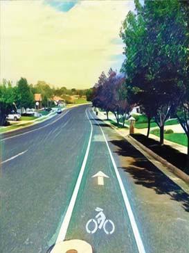
20 PERRY CORRIDORS Figure North Connector links Willard Bay State Park to the Uinta-Wasatch-Cache National Forest. Trail Corridor Recommended Corridor Type Davis Street Other* Bicycles 3000 South/ Osmond Lane/2950 South 91 DAVIS ST 3000 SOUTH PERRY BRIGHAM CITY Perry Canyon White Rock Recommended Corridor Use EXISTING FACILITIES & FEATURES Municipal Parks Federal & State Public Lands Municipal Boundaries Roads Proposed FrontRunner Stop School Civic building Three Mile Creek Gun Range Corridor Connections Dale Young Nature Park, Mountain View Park CORRIDOR TYPES Proposed Other* Other* Pedestrian, bicycle Three Mile Creek Gun Range, Perry Civic center N Miles Proposed and Existing corridors * sidewalk, shoulder, sharrow, or path Difficulty Length (miles) Easy 1.0+ Easy 2.5 TOTAL LENGTH 2.5 Figure View down Davis St where a future corridor would provide connections to Dale Young Nature Park and rodeo area. Figure View down Davis St where a future corridor would provide connections to Dale Young Nature Park and rodeo area. 16


21 WILLARD CORRIDORS 0 EXISTING FACILITIES & FEATURES CORRIDOR TYPES Proposed Shared-Use Proposed Other* Proposed Single Track Single Track - Unofficial Other Proposed and Existing Corridors *sidewalk, shoulder, sharrow, or path Miles Figure Proposed east-west corridors for the Willard area. Trail Corridor Municipal Parks Federal & State Public Lands Municipal Boundaries Roads Proposed FrontRunner Stop School Civic building N Willard Bay State Park Recommended Corridor Types 750 North Shared-Use, Single Track Pedestrian, bicycle Center Street Other*, Single Track Pedestrian, bicycle 750 North Center St WILLARD Recommended Corridor Use Corridor Connections Difficulty Length (miles) Willard Bay State Park, National Forest National Forest, Willard Elementary, Willard civic buildings Easy, Medium 1.0 Easy, Medium 2.5 Willard Canyon Single Track Willard Canyon Waterfall Medium, Hard 1.0 TOTAL LENGTH 4.5 Willard Canyon Figure Recommended dimensions for the shared-use section of the 750 North. Figure Proposed 750 North trail 17
 6850 South")

22 SOUTH WILLARD CORRIDORS South Marina 8700 SOUTH To Weber County Rail Trail Figure Propsed east-west corridors for South Willard SOUTH 8300 SOUTH SOUTH WILLARD To Weber County Bonneville Shoreline Trail Trail Corridor Recommended Corridor Types Recommended Corridor Use Difficulty Length (miles) 6850 South Other* Pedestrian, bicycle Easy, Medium 1.0 Center Street Other* Pedestrian, bicycle Easy, Medium N 2 Miles TOTAL LENGTH 3.0 EXISTING FACILITIES & FEATURES Municipal Parks Federal & State Public Lands Municipal Boundaries Roads CORRIDOR TYPES Proposed Other* Other Proposed and Existing Corridors *sidewalk, shoulder, sharrow, path or single track 1 Figure 29. View of South Willard s active transportation corridors. 18

23 4 ACTIVE TRANSPORTATION FACILITY DESIGN GUIDE There are several elements to consider when constructing bicycle and pedestrian facilities, including trailhead, trail type, surface type, sloped, grade, lighting, landscaping, etc. For a complete list of design guidelines and elements see the 2002 American Association of State Highway and Transportation Officials (AASHTO) Guide for the Planning, Design and Operation of Pedestrian Facilities, the 2002 AASHTO Guide for the Development of Bicycle Facilities, the National Association of City Transportation Official (NACTO) 2012 Urban Bikeway Design Guide, the 2013 NACTO Urban Street Design Guide, and the 2012 American with Disabilities Act (ADA) Standards for Accessible Design. The following design guidelines are important regional recommendations to create a consistent, safe, convenient and accessible community for bicyclists and pedestrians. They are guidelines and should not be substituted for a more thorough evaluation and site analysis. Trailhead Trailheads are access points, staging areas, and information stations for corridor users. Connections between the corridor and trailhead should be clear and obvious. Trailhead signs should be situated to clearly identify the trailhead from the parking lot and provide a visual clue of where the corridor starts. Convenient access to the corridor from surrounding residential areas and businesses is key to increasing trail use. Increased trail use raises the fitness level of County residents, improves the safety of corridor facilities by adding more eyes to the corridor, and encourages more concern by the public for the condition of the corridor. Trailhead locations might be incorporated into existing businesses, parks, schools, churches, government agencies, etc., which would avoid the need to build trailhead parking facilities other improvements. Other locations to consider for trailheads is where other transportation routes converge (e.g., bus stops, train stops, marinas). Trailhead considerations: Figure 4-1. Trailhead Surface Types Trailhead Graphic There are various surface materials available for the construction of corridor tread (e.g., woodchips, soil, gravel, concrete, asphalt). When selecting a surface material, it is important to consider the corridor setting, physical 19
24 features, constraints, needs of the intended user groups and the desired final appearance. Hard or semi-hard surfaces materials (asphalt, concrete, or crushed stone) are more practical and preferred for shared-use trails, where a high volume is expected. The hard surface material tend to be more expensive Crossings Crossings are legally designated places for pedestrians and bicyclist to safely cross a road or railroad. They can occur at intersections or midblock. Marked crossings indicate optimal locations to cross and help designate right-of-way for motorists to yield to pedestrians. Corridor surfaces should permit a variety of recreational uses and be easily maintained. Corridor surfaces shall be constructed from materials that provide a firm, smooth surface and comply with ADA guildlines, where applicable. Slope The slope or grade of a corridor is a key factor in tread stability and overall accessibility of the trail. Slopes are dependent on the designated users of the corridor. Table 1 is a summary of recommended design standards for recreation trails. cross slope Figure 4-2. Cross section of a typical corridor (e.g., path, trail) Table 4-1. Summary of Design Standards for Recreation Trails Access Routes Easy Moderate Difficult Paved: asphalt, Surfacing concrete, Compacted crushed Varies, but needs to boardwalk with rock or compacted be firm and stable ramped or level earth entry Clear width (minimum) 48 in. 36 in. 28 in. Sustained running slope 5% 8.3% 12.5% Maximum grade 8.3% 10%-14% 20% For a maximum distance of 30 ft. 50 ft. 50 ft. Cross slope (maximum) 2% 3% 5% Passing space interval 200 ft 300 ft 400 ft Rest area interval 400 ft 900 ft 1,200 ft Small level changes 0.5 in. maximum 1 in. maximum 3 in. maximum *Note: No more than 20% of total length of the access route shall exceed the maximum sustained running grade **Note: Cross slop may not exceed 3% in maximum grade segments, or 5% in maximum grade segments on difficult access trails. ***Note: The measurement of a maximum grade and cross slope should be made over a 24 measurement interval to correspond to the footing of a wheelchair operating in that environment. Source: Recreation Access Advisory Committee, Recommendations for Accessibility Guidelines: Recreation Facilities and Outdoor Developed Areas, U.S. Architectural and Transportation Barriers Compliance Board, July Elements to consider when assessing intersections and crossings include: Crossing designs vary in type and are subject multiple variables depending on location and modes of transportation. See appendix X for a complete guide on the different types of crossings and best practice for user safety and comfort. Landscaping Thoughtful landscaping provides shade for corridor users, creates wildlife positive user experience. It can also reduce headlight glare and traffic dust, prevent accidental vehicle crossover, and can provide a visual and physical barrier between bicyclist, pedestrians and automobile traffic. The right landscaping materials can also mitigate the discomforts of weather by protecting the user from rain, wind and extreme heat and cold. Below are a few simple landscaping considerations for corridors in southeastern Box Elder County: on the south and southwest sides of the trail. Benches with maintenance once established. maintenance costs and to keep the corridor clear of debris. or potentially injure corridor users. runoff and to allow water to naturally percolate into the ground. This might include surfaces such as gravel, mulch, or existing soils. areas that have been excavated for corridor construction. This will help avoid erosion issues in the future and make the trail more enjoyable. 20

25 Signage Clear and consistent signage should be used to designate trailheads, recommended use, directional information, educational or historic interpretation and rules. The most important aspect of signage is to provide corridor users with a safe and comfortable experience. Signs can be regulatory, interpretive, directional and road. Regulatory signs are used to identify corridor rules and regulations. Access points are good locations for regulatory signs including trailheads and other popular high use areas. Interpretive signs are used to identify and educate users about topics, including natural, cultural and historic resources. Interpretive signs should be placed in strategic areas such as trailheads, viewpoints and other points of interest. Directionals signs are used to identify location, direction, distance and places of interest for corridor users. Markers should be at strategic intervals such as every half-mile. Road signs are used to inform motorist of trailheads or provide warnings at road crossings. Sign Recommendation: space information intersections and crossings, overlooks and scenic resources, key roadways standards set in the Manual on Uniform Traffic Control Devices. To maintain consistent signage across corridor sections it is important that communities work closely with Box Elder County to help incorporate regional corridor logos into a community s signage. The following regional corridor have been agreed upon logos and should be added to each community s respective sections: Historic Orchard Pathway, FrontRunner Trail, Bonneville Shoreline Trail and the Wetland Trail. Bonneville Shoreline Trail Logo Figure 4-5. Bonneville Shoreline Trail logo. ADA Compliance The Americans with Disabilities Act (ADA) is a federal law that ensures that all Americans have the same basic right of access to services and facilities. The ADA prohibits discrimination on the basis of disability. The ADA Accessibility Guildlines (ADAAG) was created to provide design and construction standards that comply with the ADA and are updated continually (see appendix X). Active transportation corridors can be used for a variety of activities and by people with different levels of mobility. Accessibility shall be considered in the decision-making processes for planning, designing, constructing, maintaining, and managing active transportation corridors within the region. Environmental Considerations Wetland Trail Logo Corridor placement should provide opportunities for users to observe ecological features, such as rivers, creeks, wetlands and wildlife while protecting those and other sensitive areas from over-use, degradation or fragmentation. Other sensitive areas might include riparian areas, highly endangered and sensitive species habitat. If corridors do travel through sensitive areas, special location and construction methods should be used to minimize impacts. This might include, fencing, erosion control measures, vegetation buffers (e.g., grasses, shrubs), curving the corridor out and back and other best management practices. Appendix X provides other best practice examples in greater detail. Sensitive area example Figure 4-6. Wetland Trail Logo. Figure 4-3. FrontRunner Trail logo. Figure 4-4. Historic Orchard Pathway logo. Figure 4-7. Photo. 21

26 5 IMPLEMENTATION Implementation of this plan will help to preserve active transportation and trail corridors for generations to come. To be truly effective, the plan should be adopted by local governments, and the adopted corridors integrated into communities existing planning documents and general plans. As such, the concept plan will become a guiding document for future active corridor decisions. As this plan is implemented, active transportation corridors will align correctly from community to community, and be connected seamlessly, creating a succinct and effective network of pathways and trails. Partnerships & Coordination In order for communities to be able to create connected and seamless active transportation corridors, it is crucial they continue to coordinate efforts across jurisdictional boundaries and between various public and private lands. As project partners, reaching out to adjacent property managers and land owners will help tremendously to create more effective and useful corridors. Likewise, reaching out to the public is also encouraged to make sure planners and officials are representing their constituent s viewpoints and providing amenities which benefit the community as a whole. Below is a list of current project partners. This list is merely a starting point, and should grow as the need for active transportation corridors grows in the area. Contributing Communties Marketing & Tourism Box Elder County will advertise this active transportation concept plan through various means including the county and other websites, social media, printed materials, newspapers, and, of course, word of mouth. Local cities and towns are also encouraged to promote this plan and planned corridors, marketing for their corridor sections and the regional systems as a whole. Access & Easements of the Utah State Code was written to project landowners who allow public access on their property. The purpose of the chapter states the following: Project Partners The purpose of this chapter is to limit the liability of public and private land owners toward a person entering the owner s land as a trespasser or for recreational purposes, whether by permission or by 22
27 operation of Title 73, Chapter 29, Public Waters Access Act. If the landowner does not want to allow the public on their property, an easement can often be obtained, or the property can be purchased. One of the first steps toward improving public access is for local governments and project partners to secure right-of-ways. There are several legal instruments that may be used to transfer ownership or interest in property. The legal instrument may be temporary and have specific termination clauses, as with lease or access agreement, or permanent rights to the land may be conveyed through a conservation easements or fee simple title. All easements either side of the utility or tail corridor that serves as a buffer to adjacent land uses. Easement agreements for trails keep the property in private ownership while allowing public access. Property purchase transfers ownership of the land parcel to the organization or agency that plans to develop the trail. Potential Costs The cost of constructing corridors will vary depending on location, material, length and terrain among other considerations. The following table is an estimate of the cost of construction by corridor type, including local costs based on recent projects in northern Utah. Property procurement, design, engineering, repair, maintenance costs are not included in these estimates. Table 5-1. Estimated Costs (per mile) for Pedestrian & Bicycle Facilities Utah Bicycle and Facilities Local Estimated Pedestrian Master Plan Design Guide, ft. paved multi-use path $150,000-$420,000 $700,000 Sidewalk extension to 8 ft. - $700,000 Bicycle lane (on existing $12,000* $14,000 pavement or during repaving) Remove existing markings - $48,000 (lane removal or lane/ reduction 10 ft. crushed aggregate $70,000-$100,000* $80,000-$106,000 path Natural trail $0-$700 - Boardwalk $1,000,000** $1,000,000- $1,300,000 *Logan **Bear Lake Project Funding and Sources Implementation of a regionally connected active transportation system coordination between various stakeholders. More than one funding source can and should be utilized for the implementation of corridor sections. Most funding sources allow and encourage either cash or in-kind matches. The more match an applicant can provide, the more competitive the application for funding will be. To expedite grant-writing and fundraising efforts, this section presents a list of potential funding sources and summaries for each. Regional, state and federal sources: Bear River Health Department: Provides funding for cities and communities to support active transportation through wayfinding signage projects. Specifically, the funding should help low income populations increase their physical activity levels by walking. For more information contact BRHD at (435) Wasatch Front Regional Council Funding Sources: WFRC grants contact them at (801) Congestion Mitigation/Air Quality Program (CMAQ) Federal funds administered through WFRC for transportation projects, Surface Transportation Program (STP) STP provides funds used on Federal Aid Eligible freeways, highways, arterials or collectors for projects which reduce traffic demand, such as active transportation. Transportation Alternatives Program (TAP) TAP funds are provided by the Federal Highway Administration and administered through WFRC for the construction and planning of bicycle and pedestrian facilities. Transportation and Land Use Connection Program (TLC) TLC funds are used for technical assistance such as staff time, consulting and training to local communities for planning, implementation and visioning efforts that proactively address anticipated growth. Utah Department of Transportation (UDOT) Funding Sources: these grants contact UDOT Region 1 at (801) Safe Routes to School Program (SRTS) Provides funding for non-infrastructure (e.g., education and encouragement programs) and infrastructure (e.g., new sidewalks, signage, bicycle parking) 23
28 type projects. Safe Sidewalk Program Provides funding for the construction of new sidewalks adjacent to state routes where sidewalks do not currently exist and where major construction or reconstruction, at that location, is not planned for ten or more years. Utah Department of Natural Resources (UDNR) Funding Sources: for these grants contact UDNR Land & Water Conservation Grant Program Coordinator (801) or recreational-trails-program/ Land and Water Conservation Fund (LWCR) outdoor recreation areas, such as bicycle and pedestrian paths and trails, or Recreation Trails Program (RTP) RTP provides funding for the development and maintenance of trails and trail related facilities. Projects may include the development of trailheads and restroom facilities. Utah Governor s Office of Economic Development Funding Sources: these grants visit Office of Outdoor Recreation Grant: Outdoor Recreation Infrastructure Provides funding for building infrastructure projects that offer an economic opportunity for the community with the potential to attract or retain residents and/or increase visitation to region. Office of Outdoor Recreation Grant: Youth Outdoor Recreation Program Provides funding for projects that will increase participation in outdoor recreation among young people. U.S. Department of Transportation: Federal Lands Access Program (FLAP) Provides funding to improve transportation facilities that provide access to, are adjacent to, or are located within federal lands. Transportation Investments Generating Economic Recovery (TIGER) U.S. Department of Transportation funding for innovative projects, including multi-modal and multi-jurisdictional transportation projects. Other Sources: Doppelt Family Trail Development Fund - Community Support Grant Provides funding for local nonprofit organizations that need critical funding to help get trail development or improvement efforts off the ground. Dopplet Family Trail Development Fund - Project Transformation Grant Provides funding for trail development or improvement projects. For more information visit People for Bikes Community Grant Provides funding for bike paths, lanes, trails and bridges, mountain bike facilities, bike parks and pump tracks, BMX facilities, end-of-trip facilities such as bike racks, bike parking, and bike storage as well as programs that transform city streets and initiatives designed to increase ridership or the investment in bicycle infrastructure. Utah Conservation Corps Partnership organization that provides matching funds through tools and trained labor. For more information visit Consider reaching out to local corporate partners and private citizens for donation opportunities. Thousands of other private foundations with grant programs supporting parks and recreation funding also exist. The National Recreation and park Association ( and the Foundation Center ( maintain websites with such grant opportunities. 24

29 6 CORRIDOR REGULATIONS & MANAGEMENT Administration While Box Elder County will act as the central coordinating agency for this plan and related planning process, each participating community, agency, and organization is responsible for the coordination and implementation of active transportation facilities in their respective jurisdictions and/or properties. However, since this is a regional plan, stakeholders will need to work together to implement trail sections and coordinate efforts related to pathway and trail alignments that cross jurisdictional and/or property lines. Project implementation will be most effective as multiple partners coordinate efforts. Rules & Regulations Rules and regulations should be established on a community-by-community basis and align with local codes, ordinances, and standards. When creating regulations it is important to work with various stakeholders, including the public to properly balance the needs and expectations of all potential community members through newsletters or open houses can help prevent Willard City s trail ordinance, found in Appendix X, provides a good example of rules and regulation to consider in your own community or organization. Maintenance & Repair Appropriate repair and maintenance activities increase the safety and security of those corridors for users. It will reduce incidents of litter, graffiti and Liability will also be reduced. Maintenance, repair, and management of individual pathway and trail segments will be the responsibility of the jurisdiction, organization, or agency that manages or has responsibility. Maintenance costs can be lowered through community partnerships and volunteer groups. Tasks, such as brush clearing, litter clean-up or weed removal can be performed by volunteer groups and help promote stewardship. Memorandums of understanding (MOU s) can be signed between jurisdictions to share resources or responsibilities. Preventative maintenance will also reduce future repair costs by not letting minor repairs develop into major projects. Regular maintenance activities include mowing, weed control, litter and waste collection, snow removal, and general upkeep. Other maintenance tasks can also include trail resurfacing or grooming, re-striping, replacement of signage, and other long term upkeep, depending on needs. See Appendix X for a detailed guide on maintaining pedestrian facilities for enhanced safety. Box Elder County Trails Committee It is recommended that a Box Elder County Trails Committee be established to coordinate and advance the planning, construction, and maintenance of the regional active transportation networks in the county. In other areas, committees have been an effective way of promoting, protecting, and coordinating active transportation and trail corridors. Weber Pathways in northern Utah is a prime example..weber Pathways info (add info into appendices as well). 25

30 REFERENCES Clear Air Partnership, Bike Lanes, On-Street Parking and Businesses: A Study of Bloor Street in Toronto s Annex Neighborhood, February 2009, Community Cycles, Dollars and jobs: The Value of Boulder s Bicycle Related Economy, Results of Community Cycles Economic Survey, November 2011, Nov_2011.pdf Godbey, Geoffery, Outdoor Recreation, Health, and Wellness: Understanding, and Enhancing the Relationship, May 2009, org/research/publications/outdoor-recreation-health-andwellness-understanding-and-enhancing Jacobson, Chris, Wake the Bay: Your April Willard Bay Fishing Report, April 2016, ishing-report/ National Association of Home Builders, Economic & Housing Policy Group, What Home Buyers Really Want, May 2013, what-home-buyers-want-2013.aspx National Park Service, Economic Impacts of Protecting Rivers, Trails, and Greenway Corridors, 1995, rtca/econ_all.pdf U.S. Census Bureau, QuickFacts: Brigham City, Utah, September 2016, Want, Guijing; Macera, Caroline; Schudder-Soucie, Barbara; Schmid, Tom; Pratt, Michael; & Buchner, David, A Cost-Benefit Analysis of Physical Activity Using Bike/Pedestrian Trails, sienadeepservice.pbworks.com/f/cost+benefit+analysis+-- +Health.pdf 26 1 Chris Jacobson, Wake the Bay: Your April Willard Bay Fishing Report, April 2016,

31 APPENDIX A: EAST/WEST TRAIL ANALYSIS Elder County Trails Concept Plan. This process ensured proposed trails were justified based on community data and local knowledge and not just opinion. This approach followed three major step: identify origins and destinations, route analysis, and identify primary and alternative east/west trails. 1. Identify Origins and Destinations Origins where people begin their trip were determined based on housing units from address point data. These locations were further analyzed in ArcGIS using kernel density spatial analysis tool to identify where population centers were located. The kernel density tool took the point data and created a density map to show where a clustering of points is occurring. Points where placed over high density areas to represent population centers or origins. South Willard Population Density A site analysis was completed in Google Earth to determine destinations locations people would likely visit. Destinations included: Schools Civic buildings including, city halls, police departments, and hospitals Religious institutions Entertainment including, restaurants, shops, grocery stores, gas stations, and hotels Parks including, Willard Bay State Park, Bear River Migratory Bird Refuge, Cache National Forest, municipal park, and trailheads Transportation including, bus stops, and future Utah Transit Authority (UTA) Front Runner stations Destination points were imported into ArcGIS and kernel density spatial analyst tool was used to determine where clustering of destinations was occurring. Points where placed over the high density areas and other important destinations including schools, civic buildings, parks, and future UTA Front Runner stations, to represent regionally significant destinations. 2. Route Analysis Willard Origin map showing high densities of housing in city centers and the population centers (origins). Brigham City Next, the network analyst closet facility solver was used to find the shortest distance from origins to destinations using the current road and planned trail network. Perry Southeastern Box Elder County Trails Corridor Plan


32 Willard Perry Bear River Migratory Bird Refuge Brigham City Destination Point Density All Destination Points Regionally Mantua The destination map displaying higher densities of destinations in downtown Brigham City, southern Brigham City, and Willard s city center. Regionally significant signify important destination points. The results of the origin-destination solver displaying the shortest distance between each origin and destination. The result are a complex system of routes that shows the importance of the north/south corridor and the numerous potential east/west routes. The closest facility solver was then run for each origin. The results for each route were overlaid on top of each other to see where routes overlap. 28 Southeastern Box Elder County Trails Corridor Plan 2016

33 The results of the closest facility solver displaying all the routes that can be taken to get from each origin to every destination. The analysis begins to show the major east/west routes including, Mantua and the Bear River Migratory Bird Refuge. The results also show the need for further analysis in Willard, Perry and Brigham City due to the number amount of potential routes. 1-3 Routes 4-8 Routes Routes 9-17 Results of the closest facility solver for each route. The darker the line the more routes use that section of trail or road. This helped identify significant east/west routes especially within communities. Southeastern Box Elder County Trails Corridor Plan
34 3. Identify Primary and Alternative East/West Trails East/west trails were determined based on the following criteria: Connections to existing trails Compliance with existing trail plans The complexity of the route: is it linear, does it need to turn too many times? Safety: does it need to cross or parallel a major road or highway? Compatibility with neighborhood and existing development types The primary routes were the ones that considered most of the above criteria. Alternative routes were also identified to provide more than one option for communities to consider, especially as circumstance change. The final east/west trail proposal map display the primary and alternative trails that will best move people from origins to destinations in a safe, efficient and aesthetically cool way. 30 Southeastern Box Elder County Trails Corridor Plan 2016

35 SOUTHEASTERN BOX ELDER COUNTY PROPOSED EAST/WEST TRAILS Southeastern Box Elder County Trails Corridor Plan

 U.S.")
 Proposed Trails Primary")


36 SOUTH WILLARD SECTION Planned Trails Frontage Road Connector Bonneville Shoreline Trail (BST) U.S. Rout Shared Lane () Historic Orchard Pathway (HOP) Union Pacific Pathway (UP) Proposed Trails Primary Trails Alternative Trails WILLARD SECTION Planned Trails Frontage Road Connector Bonneville Shoreline Trail (BST) U.S. Rout Shared Lane () Historic Orchard Pathway (HOP) Union Pacific Pathway (UP) Proposed Trails Primary Trails Alternative Trails 32 Southeastern Box Elder County Trails Corridor Plan 2016


")
 Union")
 Proposed")


37 PERRY SECTION Planned Trails Frontage Road Connector Bonneville Shoreline Trail (BST) U.S. Rout Shared Lane () Historic Orchard Pathway (HOP) Union Pacific Pathway (UP) Proposed Trails Primary Trails Alternative Trails Proposed Trails Primary Trails Alternative Trails To Bird Refuge BRIGHAM CITY SECTION Planned Trails Frontage Road Connector Bonneville Shoreline Trail (BST) U.S. Rout Shared Lane () Historic Orchard Pathway (HOP) Union Pacific Pathway (UP) Proposed Trails Primary Trails Alternative Trails Southeastern Box Elder County Trails Corridor Plan 2016 To Mantua 33
City of Durango 5.8 FUNDING TRAILS DEVELOPMENT
 5.8 FUNDING TRAILS DEVELOPMENT The City has been successful in establishing dedicated local funding sources as well as applying for grants to develop the City s trail system, having received nearly $2.4
Chapter 6: POLICY AND PROCEDURE RECOMMENDATIONS
 Chapter 6 POLICY AND PROCEDURE RECOMMENDATIONS FOR SRRA Below are seven policy elements that should be considered for adoption by the Southwest Regional Recreation Authority of Virginia: 1. Develop strategies
FEASIBILITY CRITERIA
 This chapter describes the methodology and criteria used to evaluate the feasibility of developing trails throughout the study areas. Land availability, habitat sensitivity, roadway crossings and on-street
A CASE FOR COMPLETING THE JORDAN RIVER PARKWAY: A
 A CASE FOR COMPLETING THE JORDAN RIVER PARKWAY: A safe crossing at 9000 South and 850 West Proposed 9000 South Underpass Parkway Timeline Parkway, Trail, and Tourism Facts Blueprint Jordan River 1971 1973
Appendix 3. Greenway Design Standards. The Whitemarsh Township Greenway Plan
 Appendix 3 Greenway Design Standards This chapter discusses two design standards for the greenway types discussed above. First, trail design standards are presented together with trailhead facilities and
The Vision for the San Juan Islands Scenic Byway
 The Vision for the San Juan Islands Scenic Byway 2 Judd Cove, Orcas Island, Courtesy of Kurt Thorson (kurtthorson.com) and San Juan County Land Bank Vision for the San Juan Islands Scenic Byway The San
Georgetown-Lewes Rail/Trail Study. Rail/Trail Study: Cool Spring to Cape Henlopen State Park New Road Extension (House Resolution No.
 Georgetown-Lewes Rail/Trail Study Rail/Trail Study: Cool Spring to Cape Henlopen State Park New Road Extension (House Resolution No. 47) August 22, 2011 Presentation Outline Background Benefits Statewide
2. Goals and Policies. The following are the adopted Parks and Trails Goals for Stillwater Township:
 D. PARKS AND TRAILS 1. Introduction Stillwater Township s population is relatively low, with most residents living on rural residences on large lots. The need for active park space has been minimal in
Blueways: Rivers, lakes, or streams with public access for recreation that includes fishing, nature observation, and opportunities for boating.
 Parks, Open Space and Trails PRINCE WILLIAM COUNTY 2008 COMPREHENSIVE PLAN TRAILS PLAN CONTENTS The components of the trails plan are: Intent Definitions Goals, Policies, and Action Strategies Trails Map
Longmont to Boulder Regional Trail Jay Road Connection DRAFT FINAL REPORT
 Longmont to Boulder Regional Trail Jay Road Connection DRAFT FINAL REPORT December 2018 Project Summary Boulder County, Colorado, in partnership with the City of Boulder, is evaluating options for multi-use
Waukee Trailhead Public Art and Amenities Project
 Waukee - Trailhead Public Art and Amenities Project Sponsor Waukee Project Title Waukee Trailhead Public Art and Amenities Project Termini Description ( i.e. Park Avenue to 19th Street) NE Intersection
Those with Interest in the City of Cambridge Trail System
 Community Services Department City Hall 50 Dickson Street, P.O. Box 669 Cambridge ON N1R 5W8 Tel: 519-740-4681 July 20, 2010 To: Re: Those with Interest in the City of Cambridge Trail System City of Cambridge
CHAPTER III: TRAIL DESIGN STANDARDS, SPECIFICATIONS & PERMITS
 CHAPTER III Trail Design Standards, Specifications & Permits This chapter discusses trail standards, preferred surface types for different activities, permits, and other requirements one must consider
2016 Regional Transportation Alternatives Program (TAP) Grant Application
 Grant Application") 2016 Regional Transportation Alternatives Program (TAP) Grant Application PROJECT TITLE: Yelm-Tenino Trail Extension Feasibility Study TRPC use only GENERAL PROJECT INFORMATION Agency or Organization City
2016 Regional Transportation Alternatives Program (TAP) Grant Application PROJECT TITLE: Yelm-Tenino Trail Extension Feasibility Study TRPC use only GENERAL PROJECT INFORMATION Agency or Organization City
DATE: 23 March, 2011 TO: Communities FROM: BlazeSports America. RE: Accessible Trails Checklist 1
 M E M O R A N D U M DATE: 23 March, 2011 TO: Communities FROM: BlazeSports America RE: Accessible Trails Checklist 1 The purpose of the Accessible Trails Checklist (below) is to help the community review
Welcome to the Cross County Trail Public Input Session!
 Welcome to the Cross County Trail Public Input Session! Please sign in on the table below! What are we doing here? Camden County has proposed a bicycle and pedestrian trail spanning across the entire county.
BST Coalition Annual Report 2005
 BST Coalition Annual Report 2005 I. Introduction The Bonneville Shoreline Trail Coalition (Coalition) is an organization of entities, both citizen and governmental, representing the communities in Utah
Business Item No
 Metropolitan Parks and Open Space Commission Meeting date: February 6, 2018 For the Community Development Committee meeting of February 20, 2018 For the Metropolitan Council meeting of February 28, 2018
Non-Motorized Transportation
 Non-Motorized Transportation Non-motorized facilities are important components to the transportation system. They provide an environmentally-friendly, low-cost mode of travel. Some of the facilities can
Outdoor Developed Areas
 The United States Access Board is an independent federal agency that promotes equality for people with disabilities through leadership in accessible design and the development of accessibility guidelines
What s covered. What s not covered. Options for those not covered. ABA Coverage
 The United States Access Board is an independent federal agency that promotes equality for people with disabilities through leadership in accessible design and the development of accessibility guidelines
AGENDA ITEM 5 D WAKULLA ENVIRONMENTAL INSTITUTE (WEI) TRAIL FEASIBILITY STUDY
 TRAIL FEASIBILITY STUDY") March 19, 2018 AGENDA ITEM 5 D WAKULLA ENVIRONMENTAL INSTITUTE (WEI) TRAIL FEASIBILITY STUDY TYPE OF ITEM: Action STATEMENT OF ISSUE The Wakulla Environmental Institute (WEI) Trail is one of several trails
March 19, 2018 AGENDA ITEM 5 D WAKULLA ENVIRONMENTAL INSTITUTE (WEI) TRAIL FEASIBILITY STUDY TYPE OF ITEM: Action STATEMENT OF ISSUE The Wakulla Environmental Institute (WEI) Trail is one of several trails
METROPOLITAN COUNCIL 390 North Robert Street, St. Paul, MN Phone (651) TDD (651)
 TDD (651)") METROPOLITAN COUNCIL 390 North Robert Street, St. Paul, MN 55101 Phone (651) 602 1000 TDD (651) 291 0904 DATE: June 19, 2007 TO: Metropolitan Parks and Open Space Commission FROM: Jan Youngquist, Senior
METROPOLITAN COUNCIL 390 North Robert Street, St. Paul, MN 55101 Phone (651) 602 1000 TDD (651) 291 0904 DATE: June 19, 2007 TO: Metropolitan Parks and Open Space Commission FROM: Jan Youngquist, Senior
MORGAN CREEK GREENWAY Final Report APPENDICES
 APPENDICES MORGAN CREEK GREENWAY Appendix A Photos of Existing Conditions in Trail Corridor Photos of existing conditions Main trail corridor - February 2009 Photos of existing conditions south bank Morgan
DRAFT - APRIL 13, 2007 ROUTING STUDY FOR TRAIL CONNECTIONS BETWEEN CALAIS AND AYERS JUNCTION
 DRAFT - APRIL 13, 2007 ROUTING STUDY FOR TRAIL CONNECTIONS BETWEEN CALAIS AND AYERS JUNCTION Abstract The vision for the East Coast Greenway is an off-road urban trail system running from Calais, Maine
The Baker/Carver Regional Trail is intended to
 Section V Design Guidance The Baker/Carver Regional Trail is intended to safely accommodate 183,000 annual visits, an array of non-motorized uses, a variety of skill levels, and persons with special needs.
Airport Planning Area
 PLANNING AREA POLICIES l AIRPORT Airport Planning Area LOCATION AND CONTEXT The Airport Planning Area ( Airport area ) is a key part of Boise s economy and transportation network; it features a multi-purpose
Lafourche Parish Government REQUEST FOR QUALIFICATIONS. Landscape Architectural Services
 Lafourche Parish Government REQUEST FOR QUALIFICATIONS Landscape Architectural Services Bayou Lafourche Parish Multi-Use Path Feasibility Study Phase 1 And Bayou Lafourche Parish Multi-Use Path Feasibility
NEWBORO AND PORTLAND HARBOUR REDVELOPMENT PLANS
 INTRODUCTION The Municipal docks in both Newboro and Portland were transferred to the Township of Rideau Lakes by Parks Canada in 2002. Little has been done to improve the docks physical condition or role
Blue River Trail Master Plan JSA to Town Hall June 2004
 Blue River Trail Master Plan JSA to Town Hall June 2004 Prepared for: Silverthorne Town Council Silverthorne SPORT Committee Department of Recreation and Culture Silverthorne Public Works Silverthorne
University Region Non-Motorized Plan 2015
 Non-Motorized Transportation Non-motorized facilities are important components to the transportation system. They provide an environmentally-friendly, low-cost mode of travel. Some of the facilities can
Citrus Heights Creek Corridor Trail Project Trail Advisory Group Field Trip #2 September 11, :00 11:00 am Trellis Hall, Citrus Heights
 September 11, 2013 9:00 11:00 am Trellis Hall, Citrus Heights Project Overview The City of Citrus Heights is studying the feasibility of establishing a multi use trail system within the City s 26 miles
Committee. Presentation Outline
 CW-33-15 11/9/2015 Community and Corporate Services Committee November 10, 2015 1 Presentation Outline Background Vision and Objectives Study Process and Timeline Public and Stakeholder Engagement Organization
Auburn Trail / Ontario Pathways Trail Connector Feasibility Study Public Information Meeting Wednesday, August 22, 2012
 Auburn Trail / Ontario Pathways Trail Connector Feasibility Study Public Information Meeting Wednesday, August 22, 2012 Purpose of Feasibility Study Purpose Evaluate the feasibility of constructing a multiuse
Trail # NW Tuesday, June DESIGN. Provide an Review the Provide an. Project Goals: System system. wayfinding
 I. Welcome / Introductions Bethany Creek Trail #2 Segment 3 Neighborhood Meeting #1 Bethany Presbyterian Church 15505 NW Springville Road, Portland, OR 97229 Tuesday, June 26, 2018 @ 6:00PM Meeting Minutes
COASTAL CONSERVANCY. Staff Recommendation September 22, 2011 BAY AREA RIDGE TRAIL: HOOD MOUNTAIN TO HIGHWAY 12
 COASTAL CONSERVANCY Staff Recommendation September 22, 2011 BAY AREA RIDGE TRAIL: HOOD MOUNTAIN TO HIGHWAY 12 File No. 11-039-001 Project Manager: Betsy Wilson RECOMMENDED ACTION: Authorization to disburse
Business Item No XXX. Proposed Action That the Metropolitan Council approve the Coon Creek Regional Trail Master Plan.
 Business Item No. 2015-XXX Metropolitan Parks and Open Space Commission Meeting date: July 7, 2015 For the Community Development Committee meeting of July 20, 2015 For the Metropolitan Council meeting
Trail Feasibility Study
 VOLUSIA COUNTY MPO CITY OF NEW SMYRNA BEACH FINAL REPORT JUNE 30, 2009 Trail Feasibility Study What s inside? 1 Introduction 2 Project Purpose & Scope 3 Physical Inventory & Assessment of Right-of- Way
Segment 2: La Crescent to Miller s Corner
 goal of the USFWS refuges is to conserve, protect and enhance fish, wildlife and plants and their habitats for the continuing benefit of the American people. Refuge lands are used largely for fishing,
Gardner: overview. Santa Fe, Oregon, and California National Historic Trails UNINCORPORATED JOHNSON COUNTY OLATHE UNINCORPORATED JOHNSON COUNTY
 Santa Fe, Oregon, and California ational Historic Trails : overview 99: p.134 100: p.135 GARDER JUCTIO 102: p.137 56: p.126 EDGERTO Burlington orthern Intermodal and Logistics 98: p.133 101: p.136 S Waverly
MUNICIPALITY OF ANCHORAGE
 MUNICIPALITY OF ANCHORAGE ANCHORAGE PARKS & RECREATION Memorandum PRC 08-56 DATE: 5 August 2008 TO: FROM: SUBJECT: Parks & Recreation Commission Holly Spoth-Torres, Park Planner PRC 08-56 Far North Bicentennial
Non-motorized Trail Plan & Proposal. August 8, 2014
 Town of Star Valley Ranch, Wyoming and the Star Valley Ranch Association in partnership with the USDA Forest Service, Bridger-Teton National Forest, Greys River Ranger District Non-motorized Trail Plan
Rule Governing the Designation and Establishment of All-Terrain Vehicle Use Trails on State Land
 Rule Governing the Designation and Establishment of All-Terrain Vehicle Use Trails on State Land 1.0 Authority 1.1 This rule is promulgated pursuant to 23 V.S.A. 3506. Section 3506 (b)(4) states that an
National Recreation Trail Application for Designation
 National Recreation Trail Application for Designation Introduction Thank you for your interest in the National Recreation Trail (NRT) program. Completed NRT application packages must be submitted by December
Regional Wayfinding Sign Strategy Thurston County Trails 2017
 Regional Wayfinding Sign Strategy Thurston County Trails 2017 Partners: Members and partnering organizations of the Thurston Thrives Community Design Action Team City of Lacey, City of Olympia, City of
ANCLOTE COASTAL TRAIL ALTERNATIVES ANALYSIS STUDY
 ANCLOTE COASTAL TRAIL ALTERNATIVES ANALYSIS STUDY PASCO COUNTY MPO JULY 2015 PROJECT OVERVIEW... INTRODUCTION EXECUTIVE SUMMARY CONTEXT... TAMPA BAY AREA, PINELLAS, & PASCO COUNTY S MULTI-USE TRAIL PLANS
At the time, the portion of the line through Eagle County remains wholly under the ownership of Union Pacific Railroad (UP).
.") Chapter 5 The Railroad Corridor as a Trail Corridor The intent of this chapter is to identify how the rail corridor, if available for lease or purchase in all or part, could be incorporated into the core
Chapter 5 The Railroad Corridor as a Trail Corridor The intent of this chapter is to identify how the rail corridor, if available for lease or purchase in all or part, could be incorporated into the core
Preferred Recreation Recommendations Stemilt-Squilchuck Recreation Plan March 2018
 Preferred Recreation Recommendations Stemilt-Squilchuck Recreation Plan March 2018 Below are the recommended recreation ideas and strategies that package together the various recreation concepts compiled
CHAPTER 4 -- THE LAND USE PLAN: DESCRIPTIONS AND POLICIES FOR THIRTEEN PLANNING AREAS
 CHAPTER 4 -- THE LAND USE PLAN: DESCRIPTIONS AND POLICIES FOR THIRTEEN PLANNING AREAS NORTH CENTRAL CAC AREA LITTLE VALLEY ROAD TO JUG HANDLE CREEK PLANNING AREA This planning area includes Cleone, Noyo,
Hudson Highlands Fjord Trail Draft Master Plan. April 29, 2015
 Hudson Highlands Fjord Trail Draft Master Plan April 29, 2015 Agenda Route Overview Proposed Segment Results of Community Survey on that Segment Next Steps Municipal Endorsement Environmental Review Implementation
CHAPTER 5. Chapter 5 Recreation Element
 CHAPTER 5 Recreation Element Chapter 5 Recreation Element The Recreation Element of the Meyers Area Plan is a supplement to the Recreation Element of the TRPA Regional Plan and the El Dorado County General
Understanding user expectations And planning for long term sustainability 1
 Understanding user expectations And planning for long term sustainability 1 What is a natural surface trail? It can be as simple has a mineral soil, mulched or graveled pathway, or as developed as elevated
Section 1 Introduction
 BST Coalition Annual Report 2014 Section 1 Introduction The Bonneville Shoreline Trail has been designated as Utah's Millennium Legacy Trail, as part of a White House initiative on the basis of our Governor's
CITY COUNCIL AGENDA MEMORANDUM
 To: Mayor and City Council From: Charles Ozaki, City and County Manager Prepared By: Kevin Standbridge, Deputy City and County Manager Katie Allen, City and County Engineer David Shinneman, Community Development
System Group Meeting #1. March 2014
 System Group Meeting #1 March 2014 Meeting #1 Outcomes 1. Understand Your Role 2. List of Revisions to Existing Conditions 3. Information Sources Study Area The Purpose of Mountain Accord is to Preserve
Becker County Trail Routing Feasibility Study
 2016 Becker County Trail Routing Feasibility Study CONNECTING DETROIT MOUNTAIN AND MOUNTAIN VIEW RECREATIONAL AREA TO THE HEARTLAND TRAIL BECKER COUNTY ULTEIG ENGINEERS Contents Acknowledgements...2 INTRODUCTION...3
EXECUTIVE SUMMARY PROGRAM DEVELOPMENT REPORT PURPOSE EXISTING SETTING EXPANDING PARKLAND
 EXECUTIVE SUMMARY PROGRAM DEVELOPMENT REPORT PURPOSE As the culmination of the first phase of the master planning process, this Program Development Report creates the framework to develop the Calero County
Macleod Trail Corridor Study. Welcome. Macleod Trail Corridor Study Open House. Presentation of Proposed Design Concepts
 Macleod Trail Corridor Study Welcome Macleod Trail Corridor Study Open House Presentation of Proposed Design Concepts Study Purpose Develop a corridor plan for Macleod Trail that aligns with The City s:
Lake Apopka Trail Loop Design Guidelines
 November 2002 Prepared for 14908 Tilden Road Winter Garden, FL 34787 Prepared by 140 North Orlando Avenue Suite 295 Winter Park, FL 32789 November, 2002 I. INTRODUCTION...1 II. DESIGN GUIDELINES FOR TRAILS...3
Assessing Your Trails, Keeping Them Safe and Enjoyable
 Jon Wood, PLA, ASLA Associate Vice President Stewart Bert Lynn, PLA, ASLA, LEED AP Project Manager Mecklenburg County Asset and Facility Management Assessing Your Trails, Keeping Them Safe and Enjoyable
4.0 Context for the Crossing Project
 4.0 Context for the Crossing Project This section provides background information about key features of the North Douglas Crossing project area, and opportunities and constraints. This information is important
Dungeness Recreation Area County Park Master Plan
 Dungeness Recreation Area County Park Public Outreach Meeting October 10, 2007 Project Overview USFWS Site Dungeness Recreation Area County Park Meeting Objectives: Re-Introduce project; provide status
NORTHEAST CARLTON COUNTY BICYCLE ROUTE PLAN
 NORTHEAST CARLTON COUNTY BICYCLE ROUTE PLAN 5/31/2014 and St. Louis River Trail Plan Update Produced by the Arrowhead Regional Development Commission (ARDC) in Partnership with the State Health Improvement
Jefferson County Non-Motorized Transportation and Recreational Trails Plan 2010
 Chapter 8: Goals and objectives Plan Update: The following update presents general principles, goals, and objectives related to non-motorized transportation facilities as a component of the overall transportation
Logo Department Name Agency Organization Organization Address Information 5700 North Sabino Canyon Road
 Logo Department Name Agency Organization Organization Address Information United States Forest Coronado National Forest 5700 North Sabino Canyon Road Department of Service Santa Catalina Ranger District
Little River Trail Feasibility Study
 Final April, 2014 Prepared for the State Coastal Conservancy By the Natural Resources Services Division of Redwood Community Action Agency Table of Contents Executive Summary... 1 1. Project Purpose and
Northeast Quadrant Distinctive Features
 NORTHEAST QUADRANT Northeast Quadrant Distinctive Features LAND USE The Northeast Quadrant includes all the area within the planning area that is east of Interstate 5 and to the north of State Route 44.
ALBANY-HUDSON ELECTRIC TRAIL FEASIBILITY STUDY. Final Report OCTOBER 2011
 ALBANY-HUDSON ELECTRIC TRAIL FEASIBILITY STUDY Final Report OCTOBER 2011 ALBANY-HUDSON ELECTRIC TRAIL FEASIBILITY STUDY Prepared for: Town of East Greenbush 225 Columbia Turnpike Rensselaer, New York 12144
PROPOSED ACTION South 3000 East Salt Lake City, UT United States Department of Agriculture
 United States Department of Agriculture Forest Service Uinta-Wasatch-Cache National Forest Salt Lake Ranger District 6944 South 3000 East Salt Lake City, UT 84121 801-733-2660 File Code: 1950/2300 Date:
Mt. Hood National Forest
 United States Department of Agriculture Forest Service Mt. Hood National Forest Zigzag Ranger District 70220 E. Highway 26 Zigzag, OR 97049 503-622-3191 Fax: 503-622-5622 File Code: 1950-1 Date: June 29,
PURPOSE AND NEED (CONCURRENCE POINT 1) NEW CANADA ROAD PROJECT FROM STATE ROUTE 1 (U.S. HIGHWAY 70) TO U.S. INTERSTATE 40
 NEW CANADA ROAD PROJECT FROM STATE ROUTE 1 (U.S. HIGHWAY 70) TO U.S. INTERSTATE 40") PURPOSE AND NEED (CONCURRENCE POINT 1) NEW CANADA ROAD PROJECT FROM STATE ROUTE 1 (U.S. HIGHWAY 70) TO U.S. INTERSTATE 40 Project Description The primary purpose of this project is to improve the major
PURPOSE AND NEED (CONCURRENCE POINT 1) NEW CANADA ROAD PROJECT FROM STATE ROUTE 1 (U.S. HIGHWAY 70) TO U.S. INTERSTATE 40 Project Description The primary purpose of this project is to improve the major
Railroad Safety Trail
 2.1 INTRODUCTION AND PROJECT SETTING 2.1 Introduction & Project Setting Introduction This study is the result of a directed effort on the part of the City of San Luis Obispo to carry out previously established
Committee Report. Community Development Committee For the Metropolitan Council meeting of August 12, Business Item No.
 Committee Report Business Item No. 2015-168 Community Development Committee For the Metropolitan Council meeting of August 12, 2015 Subject: Coon Creek Regional Trail Master Plan, Anoka County Proposed
Port Gamble Shoreline Area Conceptual Trail Proposal
 The North Kitsap Trails Association is pleased to be a partner to the Kitsap Forest and Bay Project and assist Kitsap County, Forterra, Olympic Property Group, Great Peninsula Conservancy and the Port
$866,000. $1,400,000 Health Benefits $13,156,000 TOTAL ANNUAL DIRECT BENEFITS. $10,890,000 Economic Benefits
 SINGING RIVER TRAIL Trails Create Value + Generate Economic Activity Trails generate economic returns through improved health, safety, and environmental conditions, raise property values, and attract visitors.
MASTER PLAN EXECUTIVE SUMMARY
 Biscuit Run State Park Scottsville Road (State Route 20) Charlottesville, VA 22902 Biscuit Run State Park MASTER PLAN EXECUTIVE SUMMARY Department of Conservation and Recreation Division of Planning and
Procedure for the Use of Power-Driven Mobility Devices on Mass Audubon Sanctuaries 1 September 17, 2012
 Procedure for the Use of Power-Driven Mobility Devices on Mass Audubon Sanctuaries 1 September 17, 2012 Background As part of Mass Audubon s mission to preserve the nature of Massachusetts for people and
BST Coalition Annual Report 2012 Table of Contents
 BST Coalition Annual Report 2012 BST Coalition Annual Report 2012 Table of Contents Introduction... 2 Progress Reports... 4 BST Committee General Efforts... 4 County by County Progress Reports... 5 Cache
FINAL TESTIMONY 1 COMMITTEE ON RESOURCES UNITED STATES HOUSE OF REPRESENTATIVES. July 13, 2005 CONCERNING. Motorized Recreational Use of Federal Lands
 FINAL TESTIMONY 1 STATEMENT OF DALE BOSWORTH CHIEF Of the FOREST SERVICE UNITED STATES DEPARTMENT OF AGRICULTURE Before the SUBCOMMITTEE ON FORESTS AND FOREST HEALTH And the SUBCOMMITTEE ON NATIONAL PARKS,
EXECUTIVE SUMMARY FALL Introduction. Findings
 EXECUTIVE SUMMARY FALL 2004 Introduction Trails are one of the most popular and highly desirable recreational resources in communities of all sizes throughout the country. In addition to providing a safe
WASHINGTON STATE PARKS AND RECREATION COMMISSION POLICY/PROCEDURE
 WASHINGTON STATE PARKS AND RECREATION COMMISSION POLICY/PROCEDURE 65-13-1 Use of Other Power-Driven Mobility Devices by Persons with Mobility Disabilities at State Park Facilities See Also: 28 CFR 35 Title
11. Recreational Trails and Pathways Needs
 11. Recreational Trails and Pathways Needs Background Walking, biking, hiking, in-line skating, canoeing, and other trail- and pathway-related activities are important to Boiseans. This importance is demonstrated
Community Development Committee
 C Community Development Committee For the Metropolitan Council meeting of October 31, 2012 Committee Report Item:2012-316 ADVISORY INFORMATION October 16, 2012 Date Prepared: Subject: Intercity Regional
COASTAL CONSERVANCY. Staff Recommendation December 2, 2004 COYOTE HELLYER COUNTY PARK BAY AREA RIDGE TRAIL
 COASTAL CONSERVANCY Staff Recommendation December 2, 2004 COYOTE HELLYER COUNTY PARK BAY AREA RIDGE TRAIL File No. 04-057 Project Manager: Amy Hutzel RECOMMENDED ACTION: Authorization to disburse up to
Environment and Natural Resources Trust Fund 2019 Request for Proposals (RFP)
") Environment and Natural Resources Trust Fund 2019 Request for Proposals (RFP) Project Title: Glacial Edge Trail and Downtown Pedestrian Bridge Category: G. Land Acquisition for Habitat and Recreation ENRTF
Environment and Natural Resources Trust Fund 2019 Request for Proposals (RFP) Project Title: Glacial Edge Trail and Downtown Pedestrian Bridge Category: G. Land Acquisition for Habitat and Recreation ENRTF
B10. Agate Beach State Recreation Site
 B10. Agate Beach State Recreation Site Location Within the City of Newport, just south of the Yaquina Head Outstanding Natural Area. The park is located along the west side of Highway 101 at the mouth
Lake Windermere Westside Legacy Trail. A multi-use non-motorized paved trail promoting health, wealth and outdoor appreciation
 Lake Windermere Westside Legacy Trail A multi-use non-motorized paved trail promoting health, wealth and outdoor appreciation Jan 26, 2015 Executive Summary The Lake Windermere Westside Legacy Trail will
Chuckanut Ridge Fairhaven Highlands EIS Scoping Concerns
 Chuckanut Ridge Fairhaven Highlands EIS Scoping Concerns Coalition of Southside Neighborhoods CSN Comments for Fairhaven Highlands EIS Scope Hearing, Jan 16, 2008 1 Chuckanut Ridge Hilly Terrain: Potential
Proposed Action. Payette National Forest Over-Snow Grooming in Valley, Adams and Idaho Counties. United States Department of Agriculture
 United States Department of Agriculture Forest Service January 2012 Proposed Action Payette National Forest Over-Snow Grooming in Valley, Adams and Idaho Counties Payette National Forest Valley, Adams
Staff Report Sign Design
 Staff Report Sign Design July 29, 2014 Planning & Zoning Commission Meeting Report date July 23, 2014 Project type Sign Design Legal description Section 2, Township 5, Range 82 Lots 3&4, S1/2NW1/4, SW1/4
ROAD AND TRAIL PROJECT APPROVAL
 ROAD AND TRAIL PROJECT APPROVAL www.marincountyparks.org Marin County Parks, 3501 Civic Center Dr, Suite 260, San Rafael, CA 94903 DATE: July 12, 2017 PRESERVE: Gary Giacomini Open Space Preserve PROJECT:
Aspen Skiing Company Policy for Use of Other Power-Driven Mobility Devices And Service Animals
 Aspen Skiing Company Policy for Use of Other Power-Driven Mobility Devices And Service Animals Introduction New rules under the Americans with Disabilities Act (ADA), Titles II and III, went into effect
Permeable RECREATIONAL TRAILS
 SMART EARTH SOLUTIONS Permeable RECREATIONAL TRAILS GEOWEB GEOPAVE GEOTERRA Innovative Solutions for Designing & Building Trails. Trail Surface Stabilization The key to planning and building trails into
Section II. Planning & Public Process Planning for the Baker/Carver Regional Trail began in 2010 as a City of Minnetrista initiative.
 Section II Planning & Public Process Planning for the began in 2010 as a City of initiative. city staff began discussions with the Park District on the possibility of a north/south regional trail connection
MONTEREY REGIONAL AIRPORT MASTER PLAN TOPICAL QUESTIONS FROM THE PLANNING ADVISORY COMMITTEE AND TOPICAL RESPONSES
 MONTEREY REGIONAL AIRPORT MASTER PLAN TOPICAL QUESTIONS FROM THE PLANNING ADVISORY COMMITTEE AND TOPICAL RESPONSES Recurring topics emerged in some of the comments and questions raised by members of the
October 23, 2017 Council Workshop
 MAPLEWOOD VILLAGE CENTRE AND INNOVATION DISTRICT IMPLEMENTATION PLAN & DESIGN GUIDELINES October 23, 2017 Council Workshop COMMUNITY PLAN Purpose of Council Workshop Highlight What We Heard Phase 3 & Key
EAST DON TRAIL ENVIRONMENTAL ASSESSMENT. Community Liaison Committee Meeting #3 July 15, :30 to 8:30 pm Flemingdon Park Library
 EAST DON TRAIL ENVIRONMENTAL ASSESSMENT Community Liaison Committee Meeting #3 July 15, 2013 6:30 to 8:30 pm Flemingdon Park Library Agenda 1. Welcome 2. Housekeeping and Updates a) Housekeeping b) CLC
National Recreation Trail Update Form
 National Recreation Trail Update Form Introduction Thank you for taking the time to complete this form. Your assistance will help ensure that the National Recreation Trail (NRT) database is complete and
COMMENT PERIOD INTRODUCTION
 To: Interested Persons From: Tom Buford File: Del Rio Trail Project Date: June 8, 2018 Community Development Department Reference: NOTICE OF PREPARATION OF AN ENVIRONMENTAL IMPACT REPORT FOR THE DEL RIO
SOUTH INTERCHANGE AREA
 Santaquin City General Plan 1 Location and Characteristics The South Interchange Area of Santaquin is located west of Interstate 15 and south of 500 South (Figure 1). It includes properties already annexed