MONTGOMERY COUNTY PLANNING DEPARTMENT THE MARYLAND NATIONAL CAPITAL PARK AND PLANNING COMMISSION
|
|
|
- Prosper Dwain Dickerson
- 5 years ago
- Views:
Transcription
1 MONTGOMERY COUNTY PLANNING DEPARTMENT THE MARYLAND NATIONAL CAPITAL PARK AND PLANNING COMMISSION MCPB Item No. 3 Date: Planning Board Tour: Purple Line/Capital Crescent Trail (replacing the Georgetown Branch Trail) David Anspacher, Senior Planner, david.anspacher@montgomeryplanning.org, Tom Autrey, Supervisor, thomas.autrey@montgomeryplanning.org, Mary Dolan, Acting Chief, mary.dolan@montgomeryplanning.org, Summary We recommend transmitting the following comments to the Montgomery County Council: Lighting Tunnel Completed: 11/09/11 Description The Planning Board has been asked to make recommendations to the County Council on several items related to the Capital Crescent Trail. Staff from coordinating agencies will be in attendance, including the Planning Department, Department of Parks, Department of Transportation (MCDOT), and the Maryland Transit Administration (MTA). 1. Provide continuous lighting on the Capital Crescent Trail between Bethesda and Silver Spring to the Illuminating Engineering Society of North America (IESNA) standard for vertical illuminance and provide maximum protection for undesirable spillover. 2. It appears that more design work is needed before a recommendation can be made with confidence on whether to construct the Capital Crescent Trail in the tunnel. a. Should further engineering investigation reveal a much lower cost or risk differential or should a mechanism present itself to provide the funds to reduce the public outlay and/or risk to the Apex Building, constructing the trail may yet be found to be feasible. b. We recommend that MTA brief the County Council in six months time with updated cost estimates and risk comparisons so that this decision can be made with greater assurance. c. If the cost differential remains, the County Council should determine the tunnel route to be financially infeasible and concentrate more effort on building the planned surface trail to accommodate the volume and variety of user groups. 3. Create a CIP project for the Capital Crescent Trail. The CIP project should provide funds to: a. Evaluate MTA engineering drawings for the trail. b. Construct the trail in conjunction with the Purple Line. 1
2 Emergency Call Boxes 4. Emergency call boxes should be included in the design of the Capital Crescent Trail. Emergency call boxes should be located as follows: a. Where there is no access to other assistance, such as long stretches between access points. b. Where cell phone coverage is spotty, such as in tunnels. c. For other reasons as deemed necessary. 5. Emergency call box locations should be selected in consultation with the Montgomery County Police Department and the Maryland National Capital Park Police, Montgomery County Division. Rock Creek Trail 6. Continue to include the master planned switchback connection to the Rock Creek Trail on the east side of the creek in the design of the Capital Crescent Trail. Landscaping / Hardscaping 7. Include additional landscaping and hardscaping in the design of the Capital Crescent Trail. Landscaping and hardscaping (including benches and trash cans) should be provided along the community side of the trail, with enhanced landscaping at stations. a. The plant materials that are selected should establish an acceptable aesthetic character for trail users when the trail is constructed and should replace the existing tree canopy in the future. b. The landscaping plan should be consistent with CPTED principles so that appropriate materials are used, for instance so they do not block trail lighting or grow to interfere with trail lighting. c. Provide hardscaping that is consistent with a park like experience. d. Provide benches with uneven, non level seating. A Better Surface Alignment for the Capital Crescent Trail between Elm Street Park and Woodmont Ave If the tunnel route is not financially feasible, the surface route becomes much more important. The following steps should be taken to provide a premier surface route through Bethesda. Even if a way is found to retain the trail in the tunnel, a similar approach should be used to assure that local access to the trail is provided in the best possible way. 8. Implement a bold redesign of the area surrounding the Capital Crescent Trail surface alignment. 9. Convene an agency working group with the mandate to develop a design and circulation concept that prioritizes the trail along the surface alignment. 10. The working group will be composed of representatives from MCDOT, State Highway Administration (SHA), Department of Parks, Town of Chevy Chase and the Planning Department. 11. The priorities of the working group will include: a. Providing an off road path that is wide enough to accommodate anticipated demand (12 ft is recommended). b. Creating a continuous trail experience from Silver Spring to downtown Bethesda that extends the lighting, landscaping, benches, and other amenities to the surface alignment. c. Prioritizing pedestrians and cyclists crossing Wisconsin Ave to ensure a safe and convenient crossing, even if travel time for motorists must increase. 2
3 d. Separating trail users from non trail users in areas where a large number of non trail users are likely to be present. e. Minimizing the number of driveways that cross the trail. f. Completing the surface alignment prior to completion of the Purple Line as part of the Bethesda Bikeway and Pedestrian Facilities CIP project. 12. The following treatments are the level of investment that we recommend as the starting point for the working group: a. Evaluate the design of the surface alignment through Elm Street Park to ensure that it will safely accommodate the anticipated heavy use, and to minimize negative impacts to park users and facilities. b. The working group should identify a preferred location for the path on 47 th Street. c. At the intersection of 47 th Street and Willow Lane create a four way stop with a raised crosswalk due to the expected volumes of trail users. d. The working group will determine which side of the road to locate the trail on Willow Lane. e. Eliminate conflicts for pedestrians crossing Wisconsin Ave. This could be accomplished by: o Prohibiting left turns from Bethesda Ave to northbound Wisconsin Ave and prohibit right turns on red in the southbound direction to eliminate all conflicts between trail users and motor vehicles. o Providing a pedestrian only phase across Wisconsin Ave. f. Realign the crosswalk on the north leg of the Wisconsin Ave / Willow Lane intersection so that it connects directly to Willow Lane. g. On Bethesda Avenue: o Locate the trail on the north side of Bethesda Ave o Remove a row of parking on between Wisconsin Ave and Woodmont Ave as recommended in the sector plan. o Implement the following typical section on Bethesda Ave between the existing curbs: from north to south include a 12 ft trail, 2 ft buffer, two 11 ft traffic lanes, and an 8 ft row of parking. o Consolidate driveways to the extent possible. 13. The master planned surface route should remain on the north side of Bethesda Avenue and any private development or public projects potentially affecting that route will be required or advised, respectively, that the Bethesda Avenue bike route needs to be accommodated until: a. A better surface alignment is identified. b. We have assurance from other parties involved including SHA and MCDOT that they concur with the new surface alignment and will ensure that a high quality, safe route is feasible. c. The master plan is amended. 3
4 Introduction The Maryland Transit Administration (MTA) recently received permission from the Federal Transit Administration (FTA) to begin Preliminary Engineering for the Purple Line light rail project. During this phase, more detailed engineering of the Purple Line and the Capital Crescent Trail will be developed. The current cost estimate for the trail is $93.9 million in 2011 dollars (not including lighting, emergency call boxes and additional landscaping/hardscaping). While the trail will be largely funded by the County, there will be negotiations with MTA to determine those costs that are the responsibility of the County and those that are the responsibility of the State. MTA may ultimately cover some portion of the $93.9 million, but those negotiations have not yet begun. MTA is seeking guidance on whether to include five items in the design of the Capital Crescent Trail. They have prepared a white paper (Attachment A) discussing four of the items and their costs: Landscaping/hardscaping: $1.7 million Lighting: $7.3 million Emergency call boxes: $0.4 million Whether to construct the trail in the tunnel beneath Wisconsin Ave as currently planned: $40.5 million The first three items represent a cost of approximately $9.4 million, which is in addition to the $93.9 million cost estimate. The fourth item, the portion of the trail that runs in a tunnel under the Apex Building, Wisconsin Ave, and the Air Rights Building in Bethesda and above the Purple Line, represents about 43% of the total trail cost because of the change in grade that will require complex engineering solutions. A fifth item the connection between the Capital Crescent Trail and the Rock Creek Trail is not included in the white paper, but MTA has requested guidance on the type of connection to design. The $1.4 million cost of the master planned connection is included in the cost estimate for the trail, but there are three other alternatives that could be considered in lieu of the master planned connection. Background The Capital Crescent Trail is an off road multi use trail that forms a crescent as it travels from Georgetown to Silver Spring via Bethesda in the Georgetown Branch right of way. Montgomery County purchased the right of way in 1988 between the DC Line and the CSX tracks just west of Silver Spring. M NCPPC has jurisdiction over the portion between the DC Line and Bethesda and the Montgomery County Department of Transportation has jurisdiction over the portion between Bethesda and Silver Spring. In 1990, the National Park Service acquired the Georgetown Branch from Georgetown to the DC Line. The Capital Crescent Trail is paved from Georgetown to Bethesda. The right of way from Bethesda to Silver Spring is currently called the Interim Georgetown Branch Trail and has a gravel surface. It will be paved in conjunction with the Purple Line project, currently estimated to start construction in 2015 and be completed in 2020, at which time this segment will take the Capital Crescent Trail name as well. This segment will be 12 ft wide with 2 ft unpaved shoulders on each side, to the extent feasible 1. It will serve both a recreational and commuter function, as well as providing direct access to both the Purple Line and the Bethesda and Silver Spring metrorail stations. 1 Per County Council direction 4

5 The Capital Crescent Trail is an important part of the countywide and regional trail and bikeway network and will connect to four other major trails, as shown in the map below. The Silver Spring Green Trail is in various stages of completion and will run between Spring Street and Sligo Creek Trail along Second Ave and Wayne Ave, connecting to the Capital Crescent Trail at the Paul Sarbanes Transit Center. Some portions will also be constructed with the Purple Line. The Metropolitan Branch Trail is in various stages of completion and will run from the Paul Sarbanes Transit Center to Union Station in DC. The Rock Creek Trail is a north south trail that connects to the Capital Crescent Trail between Chevy Chase Lake and Lyttonsville. C&O Canal Towpath Illustration of Regional Trails 2 2 Note that the Rock Creek Trail in Montgomery County is distinct from the Rock Creek Park trails in Washington, DC. The Rock Creek Trail is an 18+ mile paved trail extending from Lake Needwood to the DC line. 5
6 Montgomery County has made several commitments to the Purple Line project: Georgetown Branch Right of Way: As noted above, the County purchased the right of way in Bethesda South Entrance: Provides a new south entrance to the Red Line metrorail station and the future Purple Line station on Elm Street west of Wisconsin Ave. The entrance would provide several elevators that connect Elm Street, the Purple Line station, and the Red Line station. This project is funded for $60 million in the CIP and constructed is expected to begin in FY 2013 (see Attachment B). Maintenance responsibility for bridges, structures, walls, pavement, and landscaping associated with the Capital Crescent Trail. Planning Board Tour of the Capital Crescent Trail On November 3, 2011, the Montgomery County Planning Board toured two segments of the Capital Crescent Trail. This included the surface and tunnel alignments of the trail in Bethesda and the connection to the Rock Creek Trail. A summary of the tour notes is provided in Attachment C. Overview The table below indicates the relative importance that staff has assigned to each of the five items, as well as the different aspects of the trail experience that each item affects. Lighting received the highest rank because it promotes physical safety and personal security throughout the entire 4.5 mile length of the trail, while enabling the trail to be used as a commuter/transportation route during hours of darkness. While the tunnel is an important part of the trail in Bethesda, it has less importance to trail users east of Bethesda, and so was ranked second. Emergency call boxes also provide an important role in creating a secure environment, though to a lesser extent than lighting. Both the Rock Creek Trail connection and landscaping/hardscaping are important to the trail, but should be secondary to lighting, the trail in the Bethesda tunnel, and emergency call boxes. In both instances their implementation could be delayed if necessary. Item Lighting Trail in the Bethesda Tunnel Emergency Call Boxes Rock Creek Trail Connection Landscaping / Hardscaping Staff Ranking Area of Trail Impacted Entire trail Bethesda Entire trail Rock Creek Park Entire trail Physical Safety X X Personal Security X X Travel Time X X Aesthetics X X X X Transportation Use X X X X Recreation Use X X X X Note: the costs for lighting, emergency call boxes, and enhanced landscaping/hardscaping have not been included in the $93.9 million cost estimate for the trail. 6
7 Lighting Lighting is not included in the existing cost estimate for the Capital Crescent Trail, but is integral to creating a safe and secure environment for trail users. Since the trail will provide local access to the Purple Line, it will serve a transportation function for commuters and others. Therefore, it is important that the trail be well lit during the Purple Line s hours of operation, which are assumed to be one hour before and one hour after the Washington Metropolitan Area Transit Authority s (WMATA) hours of operation 3. The Illuminating Engineering Society of North America s (IESNA) RP 8 00 Roadway Lighting publication is the current standard that most state departments of transportation (DOTs) and other municipalities adopt in either portion or entirety for their own lighting standards. This publication recommends that three criteria be satisfied when completing the lighting design for a shared walkway/bikeway: Average Horizontal Illuminance: This criterion measures how well users are able to see the path ahead of them to detect potholes, debris, puddles, etc, and therefore is an indication of physical safety. It measures the average light levels reaching all points on the surface of the trail. Minimum Vertical Illuminance: This criterion measures the ability to detect facial features and to see the front and backs of trail users. It is an indication of personal security. Uniformity Ratio: This criterion measures the consistency of the lighting and therefore applies to both physical safety and personal security. A lower uniformity ratio is preferable because it indicates a more consistent level of lighting. A higher uniformity ratio could mean that there are lighter and darker spots along the trail. According to the white paper, MCDOTs current practice is to light all trails within the public right of way that expect significant use during darkness. MCDOTs practice adheres to the IESNA standard for horizontal illuminance and uniformity ratio, but does not use the vertical illuminance standard. This is consistent with the lighting practices of other DOTs. While current practice might be sufficient for other trails, the Capital Crescent Trail will be different than a typical off road trail because it will serve a local access function to communities and to the Red Line and Purple Line stations at night. Applying the vertical illuminance standard to the Capital Crescent Trail is important part of providing security on the trail. Providing lighting to the vertical illuminance standard requires a closer spacing of light poles. Whereas current Montgomery County practice would space the poles 65 to 70 ft apart and have a capital cost of about $3.1 million, satisfying the IESNA standard would require pole spacing from 30 ft to 50 ft and would have a capital cost of about $7.3 million. Either of these options would add that cost to the $93.9 million estimated cost for the Capital Crescent Trail. We do not have an estimate of the annual operating costs for a lighting system. A concern of residents whose homes back up to the trail is that lighting will spill over into their homes. According to MTA s consultants, recommending closer pole spacing does not have to increase the amount of light that spills over if the lighting is designed appropriately. In fact, this spill over can be 3 The County has not made a formal decision on operating hours. WMATA opens at 5:00 am Monday to Friday and 7:00 am on Saturday and Sunday. It closes at midnight Sunday to Thursday and 3:00 am on Friday and Saturday night. 7
8 eliminated by installing fixtures that prevent the light from rising above the level of the fixture and from extending beyond the desired area. We recommend providing continuous lighting on the Capital Crescent Trail between Bethesda and Silver Spring to the Illuminating Engineering Society of North America (IESNA) standard for vertical illuminance and provide maximum protection for undesirable spillover. This standard of lighting is somewhat higher than the MCDOT practice for trails but is warranted because safe and secure local access is needed to the Red Line and the Purple Line and to function as a commuter trail during hours of darkness. 8

9 Tunnel Under the planned scenario, the Capital Crescent Trail would run in a tunnel in the Georgetown Branch right of way under the Apex Building, Wisconsin Ave, and the Air Rights Building in Bethesda and above the Purple Line, as shown in the figure below. Thirty five existing columns supporting the Apex Building would need to be reconstructed or strengthened and 3 bracing grade beams would need to be relocated/reconfigured along Elm Street. Temporary supports for the Apex Building would need to be constructed to allow the work to take place. The cost to construct the trail in the tunnel is about $40.5 million, or 43% of the total cost of the trail, even though it represents only about 4% of its length. The cost and concerns about risk associated with construction have caused some stakeholders to question whether both the Purple Line and the trail should be built in the tunnel or whether only the Purple Line should be built in the tunnel. Master Plan Guidance Several master plans have provided guidance on the Capital Crescent Trail: The Georgetown Branch Master Plan Amendment (1990) recommended that the Georgetown Branch right of way include a predominately single track trolley route and a 10 ft hiker/biker path. Four segments of the right of way were to be double tracked, one of which was the tunnel under Wisconsin Ave. 9

10 The 1994 Bethesda CBD Sector Plan (page 147) recommended that the Georgetown Branch consist of a light rail transit line and a recreational trail between the Central Business Districts of Bethesda and Silver Spring. The Capital Crescent Trail was recommended to be 10 ft wide and to include two permanent alignments in downtown Bethesda, shown in the map below. The tunnel alignment, shown as a solid blue line, starts at Woodmont Plaza and travels east beneath the Apex Building, Wisconsin Avenue, and the Air Rights Building before emerging at Elm Street Park. The tunnel alignment would be constructed in conjunction with the Purple Line. The tunnel alignment provides an efficient connection to downtown Bethesda and to the existing trail between Bethesda and Georgetown, as it avoids an at grade crossing at Wisconsin Avenue. The surface alignment, shown as a dashed red line, also starts at Woodmont Plaza, travels east on the north side of Bethesda Avenue, crosses Wisconsin Avenue at a signalized intersection, continues onto Willow Lane, and then heads north through Elm Street Park. Completion of the surface alignment is included in the County s Capital Improvement Program (CIP) as the Bethesda Bikeway and Pedestrian Facilities project (see Attachment D). This project is on hold for the construction of the Lot 31 joint development/mixed use project, at the southeast corner of the Woodmont Ave/Bethesda Ave intersection, and is scheduled to begin no earlier than FY On page 156, the Sector Plan recognized that the space in the tunnel is restricted, and states that: The tunnel area for the CCT may be greatly reduced or perhaps eliminated if double tracks for the trolley are needed there. In the event that the CCT does not run through the tunnel, the CCT will follow only a street route. Location of Capital Crescent Trail Tunnel Alignment and Surface Alignment The Purple Line Functional Master Plan (2010) recommended extending the dual track light rail systems to the Prince George s County line. It also recommended a width on the Capital Crescent Trail of 12 ft 10
11 with 2 ft shoulders on either side, to the extent feasible. The trail would be elevated above the Purple Line in the tunnel. Analysis The tunnel and surface alignments are compared below in three ways: user experience, cost, and risk. User Experience The tunnel and surface alignments do not provide equivalent experiences or accommodate the same user groups equally. Tunnel Alignment: The tunnel alignment travels beneath Wisconsin Ave, avoiding crossing a busy intersection and providing an uninterrupted route to/from downtown Bethesda. This would permit all types of users (pedestrians, cyclists, skaters, joggers, etc) and all levels of bicycling ability to use the trail. It also reduces travel time, especially for pedestrians. This alignment largely avoids conflicts between trail users and non trail users. Surface Alignment: The surface alignment traverses a park, travels along segments of two streets, and requires users to cross a busy signalized intersection at grade, as well as several driveways. The trail would be designed to accommodate pedestrians and most cyclists. Because the surface alignment provides a less direct path to downtown Bethesda and it crosses at a signal, travel time is greater, especially for pedestrians. Many users could be deterred from using the surface alignment, especially parents riding a bike with young children, though they still may use other sections. There are also likely to be conflicts between trail users and non trail users on busy sidewalks if the trail is not designed appropriately. The table below summarizes the differences between the surface and tunnel alignments based on user experience. Measure Tunnel Alignment Surface Alignment Conflicts with Wisconsin Ave Traffic None At a signalized intersection Directness of Route to Woodmont Plaza Excellent Good Bicyclists Not Accommodated None Conflicts with Non Trail Users Low High Most cycling families with young children Cost According to MTA s white paper, the cost of constructing the Capital Crescent Trail in the tunnel above the Purple Line is $40.5 million more than simply placing the Purple Line within the Georgetown Branch right of way. While we accept the cost estimates for constructing both the Purple Line and the Capital Crescent Trail in the tunnel, we have questions about the $40.5 million cost differential because the designs for only constructing the Purple Line in the tunnel have not been developed to the same level as constructing both the Purple Line and the Capital Crescent Trail in the tunnel. We see two main areas of concern: 11
12 First, as currently planned, the Capital Crescent Trail transitions from the north side of the tracks to above the tracks at the Air Rights Building, just before it enters the tunnel and there is a ramp connection to Elm Street Park in the tunnel. If the trail is not constructed in the tunnel, the trail will transition from the north side of the tracks near Pearl Street to the south side of the tracks at Elm Street Park and then follow the surface alignment. It is unclear though, whether the elevation of the Purple Line will be higher than currently planned under the Air Rights Building. While MTA has confirmed that there would be sufficient clearance under the Air Rights Building to fit the trail, it is unclear what the size and cost of the structure to carry the trail over the Purple Line would be. Second, if the design of only the Purple Line in the tunnel has not been fully developed, it is unclear how MTA can definitively state whether or not any of the columns or beams in the tunnel would have to be reconstructed/reconfigured. If there are impacts to the columns or beams, this would increase the cost of the Purple Line and should be subtracted from the cost of the trail in the tunnel. In addition, to estimate the cost difference between the Purple Line and the trail in the tunnel and the Purple Line only in the tunnel it is necessary to also include the costs for a surface alignment trail. If the Purple Line and trail are both constructed in the tunnel, we assumed that the surface alignment cost would be the amount programmed in the CIP, roughly $1.0 million. If the Purple Line is in the tunnel alone, then the funds programmed for the surface alignment would likely be insufficient to accommodate the volume of users, different types of use, and differing levels of ability that could be expected. We are unable to estimate the cost to enhance the surface alignment, but it could be substantial. In short, the following table provides a cost comparison for the two scenarios. While the Purple Line and Trail in the tunnel would cost about $95.0 million, using MTA s cost estimates and information from the CIP, the Purple Line Only in the tunnel would cost $54.5 million at a minimum. This represents a differential for the trail in the tunnel of as much as $40.5 million, but it could be reduced. Purple Line and Trail in Tunnel Purple Line Only in Tunnel Trail from Silver Spring to Air Rights Building $53.5 $53.5 Trail from Air Rights Building to Woodmont Plaza via Tunnel Tunnel under Apex Building $27.0 $0.0 Tunnel under MD 355 and Air Rights Building $13.5 $0.0 Total Tunnel Alignment $40.5 $0.0 Total Surface Alignment $1.0 $1.0 Total $95.0 $54.5 Difference $
13 Risk While there is a risk to constructing the Purple Line and Capital Crescent Trail in the tunnel, the level of risk if only the Purple Line is constructed in the tunnel is unclear. Conclusion In summary, staff finds that: Constructing just the Purple Line in the tunnel reduces the cost of the trail by as much as $40.5 million. The difference in cost could be less if: o The size of the structures that takes the trail over the tracks, from the north side to the south side of the tracks, needs to increase because the trail elevation is increased. o The columns and beams in the tunnel need to be reconstructed/reconfigured in a scenario with only the Purple Line in the tunnel. o Enhancements to the surface trail are needed beyond those funded in the CIP. o Other issues are identified. The added risk associated with constructing the trail above the Purple Line in the tunnel is undetermined. Whereas the tunnel alignment would accommodate all cyclists, the surface alignment would not accommodate most families cycling with young children. Using the surface alignment increases conflicts with motor vehicles and non trail users, and increases travel time in comparison to the tunnel alignment. The question is therefore whether the additional cost and risks to the Apex Building are warranted by the additional users that will be able to use the trail, reduced conflicts, and reduced travel time. Staff believes that the benefits of constructing the trail in the tunnel do not justify an additional cost of $40.5 million and the risk to the Apex Building. However, we do not believe that the level of analysis conducted for a scenario in which only the Purple Line is constructed in the tunnel has been developed to the same level as the Purple Line with the Trail in the tunnel. More design work is needed before a recommendation can be made with confidence on this issue at this time. Comparison to Medical Center Pedestrian Tunnel Comparisons might be made to the MD 355 Crossing project. This project will construct both deep elevators on the east side of Rockville Pike to the Medical Center Metro Station and a shallow tunnel beneath Rockville Pike that enables pedestrians to avoid an at grade crossing. The Department of Defense agreed to fund the project on November 1, 2011 as part of the transportation response to the Base Realignment and Closure Act (BRAC) move of Walter Reed Army Medical Center to the National Naval Medical Center campus. During the alternative analysis for the project, the shallow tunnel component was estimated to cost $28.0 million. While this component of the project was estimated to remove about 5,000 pedestrian crossings of Rockville Pike during the average weekday if constructed alone, it will likely experience far fewer pedestrian crossings when constructed with the deep elevators. Staff estimated that it would experience about 1,100 uses per weekday, or roughly 7,000 per week. This equates to $4,000 per weekly use. The Capital Crescent Trail in the tunnel is estimated to cost about $40.5 million. In 2006, the Coalition for the Capital Crescent Trail conducted a count of trail users. They estimated about 10,100 weekly uses where the trail passes by Elm Street Park and 23,000 weekly uses just south of the Bethesda Trailhead 13
14 located near the intersection of Woodmont Ave and Bethesda Ave. When the Purple Line is complete and the trail is paved, it is likely that the weekly uses where the trail passes by Elm Street Park will approach those of the Bethesda Trailhead. Conservatively, this could probably be expected to grow to 15,000 uses per week when the Purple Line and trail are complete, and perhaps 20,000 by This equates to $2,025 per weekly use. While the Capital Crescent Trail would be less expensive per use than the Medical Center pedestrian tunnel, the Medical Center pedestrian tunnel will be 100% federally funded in support of a unique and exclusively federal mission. In addition, the trail project still carries the added risk of potential damage to the Apex Building. Therefore, while the trail is justified by usage, the fact that it carries additional risks and that it will be largely funded by the County makes this comparison informative but difficult to apply directly. Recommendation While carrying the trail through the tunnel is recommended by the Master Plan and is a high County priority, current estimates indicate that the differential in cost and uncertainty about risks to the Apex Building between the trail plus the Purple Line and the Purple Line alone in the tunnel are too great to justify the public expense. However, it appears that more design work is needed both on the Purple Line alone in the tunnel and on a revised trail connection to Elm Street Park before a recommendation can be made with confidence on this issue. Should further engineering investigation reveal a much lower cost or risk differential or should a mechanism present itself to provide the funds to reduce the public outlay and/or risk to the Apex Building, constructing the trail may yet be found to be feasible. We recommend that MTA brief the County Council in six months time with updated cost estimates and risk comparisons so that this decision can be made with greater assurance. If the cost differential remains, the County Council should determine the tunnel route to be financially infeasible and concentrate more effort on building the planned surface trail to accommodate the volume and variety of user groups. The Montgomery County Capital Improvements Program (CIP) does not have a project for the Capital Crescent Trail. We therefore recommend creating a CIP project for the Capital Crescent Trail. The CIP project should provide funds to: Evaluate MTA engineering drawings for the trail. Construct the trail in conjunction with the Purple Line. 14
15 Emergency Call Boxes According to MTA, emergency call boxes are a successful way to create a safe environment on trails. However, the experience of the Maryland National Capital Park Police, Montgomery County Division and the DC Department of Transportation (DDOT) indicates that few calls made on the system are for emergencies. Of 369 Montgomery County calls placed at call boxes in Rock Creek Park and the Matthew Henson Trail, only one appears to have been for an emergency. DDOT did not report statistics but said that in consultation with other jurisdictions, they found that call boxes are often used for nonemergency or crank calls more often than for emergencies. For this reason and because the majority of trail users carry cell phones, DDOT decided not to install call boxes on the Metropolitan Branch Trail between Union Station and Catholic University, which opened in In addition, they stated that cell phones provide a better service because they can be used at any location, whereas call boxes would be spaced at fixed intervals. MTA estimated the cost of installing 25 call boxes on the Capital Crescent Trail at ¼ mile intervals and at key locations such as stairways and tunnels to cost about $400,000. This cost is in addition to the $93.9 million estimated cost for the Capital Crescent Trail. We recommend that emergency call boxes be included in the design of the Capital Crescent Trail. Our recommendation is based on the following reasons: Not everyone owns a cell phone. A recent survey 4 found this to be the case for 15% of adults. While this number is likely to decrease in the future, many cell phone owners do not carry their cell phone when they run or ride a bike. Call boxes inform the police where a call is being made, whereas cell phone users may not be able to pinpoint their location for police until GPS technologies become ubiquitous. Call boxes can provide a deterrent to crime. Emergency call boxes should be located as follows: Where there is no access to other assistance, such as long stretches between access points. Where cell phone coverage is spotty, such as in tunnels. For other reasons as deemed necessary. These locations should be selected in consultation with the Montgomery County Police Department and the Maryland National Capital Park Police, Montgomery County Division. 4 A closer look at generations and cell phone ownership, Pew Research Center's Internet & American Life Project, February 3,
16 Rock Creek Trail Since the final elevation of the Capital Crescent Trail will be about 36 to 42 ft above the Rock Creek Trail after the Purple Line and CCT are built, MTA is investigating four potential options to connect them. The type of connection is important, because it could impact the trail user experience, extend the travel time (especially for pedestrians), and have impacts on the Georgetown Branch right of way, the creek, the park, and the residential neighborhood. The four connections are described below and illustrated in Attachment E. MTA was not able to provide cost information on three of the potential connections. #1 Susanna Lane & #3 Grubb Road: A connection via Susanna Lane currently exists through a residential neighborhood, but there are no existing sidewalks and all cyclists and pedestrians currently share the road with motorized traffic. The connection requires an 1868 ft (0.35 mile) deviation from the trails. If this option is selected as a preferred connection, it would require a 990 ft shared use path (8 to 10 ft wide) or sidewalk (minimum 5 ft wide) to separate pedestrians from motor vehicles. A connection via Grubb Road currently exists, but requires a 1634 ft (0.31 mile) deviation from the trails through a residential neighborhood. Sidewalks are available, but they are not ADA compliant. Making this a permanent connection would require about 1250 ft of shared use path (8 to 10 ft wide) or at a minimum a 5 ft sidewalk along Terrace Drive and Freyman Drive. These connections should be constructed as a pair, since doing only one or the other causes longer travel distances and inconvenience for either eastbound CCT users wanting to travel north on Rock Creek Trail or westbound CCT users wanting to travel south on Rock Creek Trail (see Attachment F). #2 Master Planned Switchback: Current County policy in the approved Purple Line Functional Master Plan (2010) is to construct a switchback trail within the Georgetown Branch ROW on the east side of Rock Creek between the Capital Crescent Trail and the Rock Creek Trail. The Facility Plan for Capital Crescent and Metropolitan Branch Trails (2001) also includes this switchback. Drawings for the Locally Preferred Alternative (LPA) show the switchback on the south side of the Purple Line, but MTA is considering shifting the switchback to the north side of the Purple Line. The switchback would need to be about 797 ft (0.15 miles) long to meet grade requirements for ADA accessibility and would require extensive retaining walls. It is not clear how extensive the impacts associated with the switchback would be. If the limit of disturbance (LOD) for the Purple Line overlaps the switchback, the additional impacts associated with the trail could be limited. The estimated $1.4 million cost of the switchback is included in MTA s estimates. #4 Jones Mill Road Switchback Extension: MTA recently developed a fourth alternative that starts at the Jones Mill Road switchback and extends east along the Georgetown Branch, about 950 ft (0.18 miles) in length. It includes a new bridge across Rock Creek and a 740 ft shared use path. The cost of the connection would be high, due to retaining walls and the new bridge. Analysis Attachment G is a matrix for evaluating the Purple Line/Capital Crescent Trail Connector Options to Rock Creek Trail that was developed by the Parks Department using information provided by MTA and their own analysis. The Master Planned Switchback connection and the Jones Mill Road Switchback Extension provide the most direct connection between trails, are the most suitable for bicyclists, and provide the highest convenience for pedestrians and persons with disabilities, but are also likely to have the highest cost. 16
17 The impacts to Rock Creek Park and the Georgetown Branch right of way are likely to be limited with the Susanna Lane and Grubb Road connections, but we are unable to determine the impacts due to the Switchback connection and the Jones Mill Road Switchback Extension, since this depends on the limit of disturbance (LOD) of the Purple Line, which has not yet been determined. If the LOD is significant, it could extend beyond the Switchback connection and the Jones Mill Road Switchback Extension, limiting the impact of these two options. However, the new bridge over Rock Creek in the Jones Mill Road Extension option would have significant impacts to the creek. Overall, the matrix gives the highest ranking to the Master Planned Switchback connection. We recommend continuing to include the master planned switchback connection to the Rock Creek Trail on the east side of the creek in the design of the Capital Crescent Trail This connection is existing County policy and provides the most direct link between the two trails. There is no basis at this time to change County policy. If it is determined that the cost of the trail needs to be reduced, this connection could be constructed at a later time, although delay would likely increase the impacts to the stream and the park and the costs would be greater. Under this scenario, the two existing connections would serve as an interim connection without improvements much as they are today. While we are not asking the Planning Board to make a recommendation on the preferred connection, the Department of Parks believes that it is better to impact the stream valley and parkland (and disrupt trail users) only once, not twice. 17
18 Landscaping / Hardscaping The existing Capital Crescent Trail cost estimate includes landscaping and hardscaping (benches) in the area between the Purple Line and the Capital Crescent Trail. It does not include landscaping or benches between the trail and the adjacent community or enhanced landscaping at stations. MTA estimates that it would cost about $1.7 million to provide additional landscaping and hardscaping: $1.2 million for landscaping along the outside edge of the Capital Crescent Trail adjacent to the community. $0.4 million for landscaping at key locations such as trail connections and in the vicinity of stations. $0.1 million for 40 six foot benches. These costs are in addition to the $93.9 million estimated for the Capital Crescent Trail. According to MTA, plants would be native or adapted to the trail and be implemented to minimize maintenance. The cost estimate includes 2.5 cal. shade trees, 8 ft ornamental trees, and 6 ft evergreen trees and shrubs. We recommend that additional landscaping and hardscaping be included in the design of the Capital Crescent Trail. Landscaping and hardscaping (including benches and trash cans) should be provided along the community side of the trail, with enhanced landscaping at stations. The plant materials that are selected should establish an acceptable aesthetic character for trail users when the trail is constructed and should replace the existing tree canopy in the future. The landscaping plan should be reviewed for compliance to CPTED principles so that appropriate materials are used, for instance so they do not block trail lighting or grow to interfere with trail lighting. We also recommend providing hardscaping that is consistent with a park like experience and benches with uneven, non level seating. Benches should be sensitively located to avoid disturbance of nearby residents. If it is determined that the cost of the trail needs to be reduced, landscaping and hardscaping could be implemented at a later time. 18
19 A Better Surface Alignment for the Capital Crescent Trail between Elm Street Park and Woodmont Ave If the Planning Board recommends only constructing the Purple Line in the tunnel, the surface alignment will become the only connection to downtown Bethesda. It therefore becomes critical that the surface alignment be designed to prioritize trail users, even if travel time for motorists must increase. We recommend that the County implement a bold redesign of the area surrounding Capital Crescent Trail surface alignment, especially if the tunnel alignment is found infeasible. In either case, an agency working group should be convened with the mandate to develop a design and circulation concept that prioritizes the trail along the surface alignment. Some elements of the trail design may vary depending on whether the tunnel alignment is available. We recommend the working group be composed of representatives from MCDOT, State Highway Administration, Department of Parks, Department of Planning, and Town of Chevy Chase and report back to the Council within three months. The priorities should be to: Provide an off road path that is wide enough to accommodate anticipated demand (12 ft is recommended). Create a continuous trail experience from Silver Spring to downtown Bethesda that extends the lighting, landscaping, benches, and other amenities to the surface alignment. Prioritize pedestrians and cyclists crossing Wisconsin Ave to ensure a safe and convenient crossing, even if travel time for motorists must increase. Separate trail users from non trail users in areas where a large number of non trail users are likely to be present. Minimize the number of driveways that cross the trail. Complete the surface alignment prior to completion of the Purple Line as part of the Bethesda Bikeway and Pedestrian Facilities CIP project. The following treatments are the level of investment that we recommend to be the starting point for the working group: Elm Street Park: The surface alignment exits the Georgetown Branch right of way roughly in the middle of the park. A 10 ft trail is included in the planned redesign of Elm Street Park. However, if the trail in the tunnel is not constructed, more users can be expected on the surface alignment than is currently being planned for. We recommend evaluating the design of the surface alignment through Elm Street Park to ensure that the trail is designed to safely accommodate the anticipated use, and to minimize negative impacts to park users and facilities. 47 th Street: This road is owned by the Town of Chevy Chase. There are several options for including a trail along 47 th Street. Replace the sidewalk with a trail in the Town of Chevy Chase right of way parallel to Elm Street Park. Remove a row of parking along the east side of 47 th Street and replace it with a trail. Route the trail through Elm Street Park. As proposed by MCDOT, bicycles travel along 47 th Street in the northbound direction and on a contra flow bike lane in the southbound direction, and pedestrians travel along the existing sidewalk. We recommend the working group identify a preferred location for the path on 47 th Street. 19
20 Intersection of 47th Street and Willow Lane: This is currently an uncontrolled intersection within the Town of Chevy Chase. We recommend that the intersection of 47 th Street and Willow Lane become a four way stop with a raised crosswalk due to the expected volumes of trail users. Willow Lane: The Bethesda CBD Sector Plan recommends an 8 ft surface alignment on the north side of Willow Lane adjacent to a 4 ft sidewalk and a 5 ft tree panel (see figure below). DOT is recommending a trail on the north side of Willow Lane because there would be fewer impacts to the Farm Women s Cooperative, utilities would not have to be relocated, and to accommodate trucks turning left onto northbound 47 th Street. This would require the elimination of the row of parking on the south side of Willow Lane. Willow Avenue just east of Wisconsin Ave Source: Bethesda CBD Sector Plan (1994) We believe that trail users would be better accommodated by locating the trail on the south side of Willow Lane. This would enable trail users to proceed directly across Wisconsin Ave. However, it would require expensive relocation of utilities and would impact the ability of trucks to turn onto northbound 47 th Street as discussedd above. A third option could be to create a dedicated space for the trail separate from non trail users by routing the trail through the Montgomery Farm Women s Cooperative s parking lot. This would require permission from the Cooperative, result in a losss of parking onsite, and need to be approved by the Historic Preservation Commission, however, the result would be a trail segment that is less subject to conflicts, with non trail users and would provide a better alignment with the crosswalk on Wisconsin Ave. We recommend that an off road trail be located on Willow Lane and that the working group determine which side of the road to locate the trail. Intersection of Wisconsin Ave and Bethesda Ave: Crossing Wisconsin Ave is the greatest impediment to creating a viable surface alignment. Therefore, it is critical to prioritize pedestrians crossing Wisconsin Ave. We recommend eliminating the conflicts for pedestrians crossing Wisconsin Ave by either: Prohibiting left turns from Bethesda Ave to northbound Wisconsinn Ave and prohibiting right turns on red in the southbound direction to eliminatee all conflicts between trail users and motor vehicles Providing a pedestrian only phase. 20
21 Both of these modifications would likely require signal retiming along Wisconsin Ave. We also recommend realigning the crosswalk on the north leg of the Wisconsin Ave / Willow Lane intersection so that it connections directly to Willow Lane. This will eliminate the need to provide a trail for a short segment along the east side of Wisconsin Ave in front of the Montgomery Farm Women s Cooperative. Bethesda Ave: The Bethesda CBD Sector Plan recommends removing a row of parking and locating the trail on the north side of Bethesda Ave (see figure below). The plan recommends an 8 ft sidewalk adjacent to an 8 ft trail and separated from traffic by a 4 ft tree panel. Bethesda Avenue just east of Woodmont Ave Source: Bethesda CBD Sector Plan (1994) The Planning Board has already received a development application for a significant mixed use project on the north side of Bethesda Ave between Wisconsin Ave and Woodmont Avenue, and the applicant has indicated concerns about compatibility with the trail. We recommend locating the trail on the north side of Bethesda Ave because it connects directly to Woodmont Plaza and the entrancee to the Red Line and future Purple Line stations. We also recommend removing a row of parking on Bethesda Ave between Wisconsin Ave and Woodmont Ave as recommended in the sector plan. Due to the high number of pedestrians using this sidewalk, a different typical section should be used. We recommend a typical section on Bethesda Ave between the existing curbs starting on the north side of the road thatt includes a 12 ft trail, 2 ft buffer, two 11 ft traffic lanes, and an 8 ft row of parking. This will physically separate non trail driveways to the extent possible. pedestrians and motor vehicles from trail users. In addition, we recommend consolidating 21

22 Comparison of the Master Planned Surface Alignment with Other Surface Alignments There have been several proposals to move the master planned surface alignment from the north side of Bethesda Ave to another location. The following is an evaluation of three alternatives to the masterplanned surface alignment via Bethesda Ave. They are illustrated in the figure below and compared in the table below. The master planned surface alignment and the modified surface alignment travel along the same roads, but vary on the side of the road along Bethesda Ave. Master Planned Surface Alignment 47 th Street: Master planned shared use path. The path would either be constructed in the park or the Town of Chevy Chase right of way. Intersection of 47 th St / Willow Lane: Currently this is an uncontrolled intersection. Willow Lane: Master planned shared use path on the north side of the road. There are two driveways. Intersection of Wisconsin Ave / Willow Lane: crosswalk does not align properly with Willow Lane. Bethesda Ave: Master planned shared use path on the north side. Requires removing one lane of parking. There is one driveway. 22
23 Surface Alignment (modified) 47 th Street: Master planned shared use path. The path would either be constructed in the park or the Town of Chevy Chase right of way. Intersection of 47 th St / Willow Lane: Currently this is an uncontrolled intersection. Willow Lane: Master planned shared use path on the north side of the road. There are two driveways. Intersection of Wisconsin Ave / Willow Lane: crosswalk does not align properly with Willow Lane. Bethesda Ave: Shared use path on the south side would conflicts with plans for the Lot 31 mixed use/redevelopment project. There are two driveways. Alternative 1: 47 th St to Willow Ln to MD 355 to Miller Ln to Woodmont Ave 47 th Street: Master planned shared use path. The path would either be constructed in the park or the Town of Chevy Chase right of way. Intersection of 47 th St / Willow Lane: Currently this is an uncontrolled intersection. Willow Lane: Master planned shared use path on the north side of the road. There are two driveways. Intersection of Wisconsin Ave / Willow Lane: crosswalk does not align properly with Willow Ln. Wisconsin Ave: can only accommodate an off road trail if a lane of traffic is removed. Intersection of Wisconsin Ave / Miller Ave: This unsignalized intersection has a divided median that permits only right in, right out movements. Miller Ave: road and sidewalks are narrow and would not accommodate an off road trail. There are numerous driveways. Woodmont Ave: could potentially accommodate an off road trail with the removal of a lane of traffic; however it is master planned for bike lanes. Alternative 2: 46 th St to Leland St to Woodmont Ave 46 th St: within the Town of Chevy Chase. It is master planned as a signed shared roadway. The off road trail would need to be constructed on the west side of the road in the Town s right ofway or remove a row of parking from county owned parking lot. Leland St: Not a master planned bikeway. This road has multiple driveways on either side of the road. Intersection of Wisconsin Ave/ Leland St: This is a signalized intersection. Woodmont Ave: could potentially accommodate an off road trail with the removal of a lane of traffic, however it is master planned for bike lanes. A comparison of the surface alignment and alternatives is shown in the table below: 23
24 Measures Route Master Plan Guidance Travel Distance to Woodmont Plaza Travel Distance to Existing Capital Crescent Trail Master Planned Surface Alignment 47 th St Willow Lane north side of Bethesda Ave Shared Use Path on all roads Surface Alignment (modified) Alternative 1 Alternative 2 47th St 47th St 46th St Willow Lane Willow Lane Leland St south side of MD 355 Woodmont Ave Bethesda Ave Miller Ave Woodmont Ave Shared Use Path on 47 th St Shared Use Path on Willow Ln No guidance on south side of Bethesda Ave Shared Use Path on 47 th St Shared Use Path on Willow Ln No guidance on MD 355 or Miller Ave Bike Lanes on Woodmont Ave Signed Shared Roadway on 46th St; No guidance on Leland St Bike Lanes on Woodmont Ave 1700 ft 1800 ft 2050 ft 2500 ft 2200 ft 2200 ft 2350 ft 2650 ft # of Driveways # of Crossings at Intersections Impacts to other Public Projects None / 3 5 Lot 31 does not incorporate a regional bike trail on Bethesda Ave or Woodmont Ave None We believe that the north side of Bethesda Ave is the best location for several reasons: It has been in the Sector Plan since Compared with other alternatives the master planned connection has: o A shorter travel distance. o Fewer crossings at intersections. o Fewer conflicting driveways. Without a plan amendment the Planning Board could not require developers to accommodate the trail if additional right of way is required. The Capital Crescent Trail east of Woodmont Plaza will serve a commuter function. The surface alignment should therefore connect directly to Woodmont Plaza, where the entrance to the Purple Line station and the Red Line station will be located. If the trail is on the south side of Bethesda Ave, trail users would have to cross additional intersections to get to the stations. If the trail was shifted to a parallel road to the south, such as Leland Street or Miller Avenue, many trail users would continue to use the more direct path along the north side of Bethesda Avenue anyway. Some potential trail users may be deterred from using the trail at all. None 24
25 We recommend that the master planned surface route remain on the north side of Bethesda Avenue and any private development or public projects potentially affecting that route will be required or advised, respectively, that the Bethesda Avenue bike route needs to be accommodated until the following criteria are met: A better surface alignment is identified. There is assurance from other parties involved including SHA and MCDOT that they concur with the new surface alignment and will ensure that a high quality, safe route is feasible. Part of that feasibility determination would be based on what the impact will be on the properties along that new route. The master plan is amended. 25


26 Attachment A Capital Crescent Trail Considerations for Montgomery County October 2011
.")
27 I. Introduction The Capital Crescent Trail (CCT) is a mixed use trail that will be constructed from the Bethesda Station to the Silver Spring Transit Center where it will connect to the Metropolitan Branch Trail and the Silver Spring Green Trail (a Montgomery County Project that will likely be constructed at the same time as the CCT, but is not part of the project). The CCT is envisioned to be both a recreational trail and a commuter trail. As a commuter trail it will connect residential communities to proposed Purple Line stations at Bethesda, Connecticut Avenue/Chevy Chase Lakes, Lyttonsville, Woodside and Silver Spring Transit Center. The CCT is proposed to be adjacent to the Purple Line transitway along the north side from Bethesda to Lyttonsville. East of Lyttonsville the CCT and the Purple Line split and run on opposite sides of the CSX/WMATA corridor until it reaches the Silver Spring Transit Center. The trail will run along the north side of this corridor with the Purple Line running on the south side of the corridor. The trail will be paved, and will typically be 12 wide with 2-foot unpaved shoulders on each side. Refer to the typical sections below. Typical Section Bethesda to Lyttonsville 1
28 Typical Section Lyttonsville to Silver Spring Transit Center The current estimated total construction cost of the CCT is $68.25 M (2011 dollars). The total trail cost of $93.94 M (2011 dollars) includes engineering services (engineering through construction) and unallocated contingencies. Refer to Appendix 1 for the May 2011 trail cost breakdown that was presented in 2010 dollars and does not include updated costs covered in this paper. Appendix 1 also includes mapping that defines the components of the trail cost that are either costs assigned to the trail, costs shared between the trail and the Purple Line Transitway, or costs that are assigned fully to the Purple Line Transitway. This cost does not include provisions for trail lighting, emergency communications, and supplemental landscape and hardscape features. County decisions required on these topics are covered later in this white paper. A significant component of the trail cost is related to both the CCT and the Purple Line occupying the space beneath the existing Apex Building, Wisconsin Avenue and the Air Rights Building. Refer to the table below that summarizes the costs related to the various components of the trail. This white paper outlines updated costs, some of the risks associated with constructing both the CCT and the Purple Line in this space and new issues that have come to light upon further investigation and design of the Bethesda Station. 2
29 Location Neat Construction (Millions) Engineering Services (Millions) Unallocated Contingency (Millions) Total (Millions) % Total Apex Building $19.60 $6.27 $1.11 $ % Wisconsin and Air Rights Building $9.80 $3.14 $0.55 $ % Other Segments of Trail $38.85 $12.43 $2.19 $ % Total $68.25 $21.84 $3.85 $ % The Capital Crescent Trail will be planned and built as part of the Purple Line, but construction will be funded by sources to be identified by Montgomery County and MTA. This white paper is being prepared to assist Montgomery County in defining their ultimate vision for the permanent Capital Crescent Trail. The decisions made by the County will be coordinated with the Maryland Transit Administration (MTA) to ensure that the Purple Line is designed to accommodate this ultimate vision. They are meant to help define a long-term vision for the trail and some elements may be implemented over time. 3
30 II. Trail at Bethesda Station a. LPA Alignment Description Several alternatives have been investigated for the Bethesda Terminal Station for the Maryland Transit Administration s (MTA) Purple Line in Montgomery County, Maryland. The Locally Preferred Alternative (LPA) layout includes a station with two (2) curved platforms beneath the Apex Building with tail or run out tracks and bumping posts extending into the Woodmont East development parcel, located to the west of the Apex Building. Side platforms would be provided under the Apex Building, with access from the street level via elevators and stairs at the corner of Elm Street and Wisconsin Avenue, as well as pedestrian access from Woodmont East. The station will be constructed around the existing columns and caisson foundations, which would protrude through the platforms. These columns will impede pedestrian flow and boardings and alightings. In order to provide adequate platform length and to meet the required vehicle clearances, the platform requires a slight horizontal curve. Patrons would have access to the proposed Washington Metropolitan Area Transit Authority (WMATA) Bethesda South Access entrance at the corner of Elm Street and Wisconsin Avenue from the station. The Interim Capital Crescent Trail (CCT) currently runs along the former Georgetown Branch of the Baltimore & Ohio (B&O) Railroad corridor through Bethesda. As part of the LPA layout, the CCT would be on an aerial structure above the tracks that gained elevation through a switchback ramp in the Woodmont East plaza. The alignments then continue east, beneath the Maryland State Highway Administration bridge that carries MD 355 (Wisconsin Avenue) over the former Georgetown Branch corridor, on a proposed rigid box structure. Beneath the Air Rights Building, a bridge structure is included to carry the CCT out of the buildings and back down to grade. A connection between the CCT and Elm Street Park will be provided. Refer to the LPA roll map and typical sections that show the arrangement of the Purple Line at several key points of interest along the alignment. b. Goals & Challenges The goals of the Bethesda Station are to present a welcoming station experience; to provide platforms of sufficient width for the expected ridership of 11,500 weekday boardings; to maximize the available space; to minimize the impacts to the existing structures, the risks associated with construction and re-development of properties surrounding the station/alignment, and the 4
31 cost of the project; to include tail tracks or over run tracks beyond the platform for two (2) tracks to facilitate operational viability of the terminal station without sacrificing the efficiency of the station; and to accommodate the CCT. Accommodating the trail, while still meeting the other area project goals, is an extremely difficult task. Although technically feasible, the risks and costs associated with the proposed stacking of the CCT above the Purple Line are substantial, as demonstrated below. c. Investigation i. Apex Building A recent study was conducted to determine the viability of placing the station and the trail in the same footprint of the former Georgetown Branch right-ofway. In order to accommodate the construction of the trail above the Purple Line, but beneath the existing Apex Building, the reconstruction or strengthening of at least 35 existing columns would be required, as well as the relocation/reconfiguration of the 3 bracing grade beams along Elm Street to provide enough room for station platforms. The column foundations for the existing building are made up of unreinforced caissons that are founded on bedrock. The first floor of the Apex Building is a transfer slab to these columns, which means that the columns cannot be relocated in order to minimize impacts to the foundations/columns. In order to accommodate the CCT and the Purple Line, the ground surrounding the unreinforced caissons Typical Section through Apex Building and Station Platforms 5
32 Typical Section through Apex Building at WMATA Access Point would need to be lowered by approximately 8 to 10 feet, resulting in the need to modify and strengthen or replace the columns/caissons. The elevations of the tops of these caissons in the Apex Building are high enough such that the trail and the tracks cannot both be constructed without exposing the unreinforced caissons. These columns and caissons are near their intended structural capacities, which further complicates the process of lowering the grade while safely and effectively supporting the structure above it. Because the caissons are unreinforced, the surrounding ground is acting as the confining element that interacts with the structural element to provide the capacity. Removing this surrounding soil would compromise the caisson s structural integrity and require the construction of temporary foundations and support frames to transfer the loads off the columns and caissons while the grade is lowered and the columns/caissons are modified, strengthened, or reconstructed. Due to the type of construction, the caisson as constructed may be irregular in shape, orientation, and size, which may result in substantial structures/obstructions in the middle of the station platforms in order to make the necessary structural modifications. Rather than retrofitting the existing columns, another option is to replace the columns at the Apex Building and extend them to the existing caisson at a lower elevation than the track subgrade; this allows for smaller column sections coming through the platform compared to the retrofitting option, but larger columns than those that currently exist. Due to low overhead clearances, however, this is likely to be a very time-consuming, tedious, and expensive procedure that carries great risks. While all buildings within the vicinity will require some level of monitoring, the Apex building will need additional and more comprehensive monitoring for settlement and rotation throughout construction while daily building activities/operation takes place. Should settlement or rotation of the building occur, construction would be halted and the building evacuated. The 6
33 building would need to be inspected/stabilized/recertified for occupancy before construction could proceed. The costs of the modifications and the risks (structurally and due to the lost productivity/occupancy of the tenants) associated with the construction may exceed the appraisal of the existing building. Regardless of whether the columns and caissons are retrofitted or replaced, the exterior wall of the Apex Building along Elm Street needs to be underpinned for up to 20 + vertically due to the fact that the bottom of wall elevation is as high as at some locations at the east end. This elevation is significantly higher than the proposed platform elevation of required in order to accommodate the CCT. There are existing grade beams that are above the proposed platform location that require removal and reconstruction. Additionally, the wall on the south side of the railroad corridor along the parking garage is not structurally adequate to act as a crash wall as required by current MTA LRT design criteria. Therefore, a wall would need to be constructed to protect the existing structure, or guardrails would need to be provided. Due to the risks and costs associated with constructing the trail within the existing constraints of the Apex Building, the idea of waiting until the Apex Building redevelops and then constructing the trail at that time has been considered. The developer would be given an envelope to redevelop around the Purple Line station and incorporate the trail at that time. However, even under redevelopment of the Apex Building, the constraints for installing the CCT above the Purple Line are driven by the Wisconsin Avenue Bridge, thereby setting the profile under the Apex Building. Refer to the roll map for the relationship between the LPA station platforms and the modified building columns. 7
34 ii. Wisconsin Avenue As the Purple Line and CCT moves east, the tracks run inside of a concrete box structure that carries the trail above the tracks under the Wisconsin Avenue Bridge. Typical Section through Wisconsin Avenue Bridge The box structure would be supported on micropiles and would not compromise the structural integrity of the existing bridge. However, the existing Wisconsin Avenue Bridge was built around an older structure. The piers of the original bridge structure were to be cut off below grade during the construction of the existing structure, and they are likely in the vicinity of the proposed concrete box structure and its pile foundation. The presence of the previous foundations needs to be considered during design and construction. In addition, the clearances for installing the Purple Line and CCT in the same space beneath the bridge are very tight. The task of avoiding impact to the existing foundations while at the same time providing the absolute minimum operating clearances for the Purple Line and the catenary system, as well as the vertical clearance for the trail is extremely tedious. The construction will need to take place with low overhead equipment and will require significant structural reinforcement of the box due to span and foundation geometry to prevent loading effects from the proposed structure on to the existing foundations. Micropiles would be used to support the box to prevent these load effects by carrying the proposed loads directly to bedrock through a below ground pile cap. 8
35 iii. Air Rights Building Inside the Air Rights Building, the track elevation is such that the top of rail is above the top of the existing caissons and the existing crash walls are acceptable for the proposed tracks, resulting in no modifications to the existing building. iv. CCT Structure Typical Section through Air Rights Building The truss/bridge structures required to support the trail within the Apex and Air Rights buildings are significant structures. In order to support the CCT and minimize impacts on the Purple Line, the structures would need to span lengths of up to 240 in order to help minimize support locations on an already constrained platform and would require tighter engineering and construction controls to reduce deflections and camber due to tight construction clearances. The span lengths may possibly be reduced for the structures not over the platforms to optimize the costs of construction and the tighter tolerances required. Due to access requirements for construction, the CCT structures and their infrastructure beneath the Wisconsin Avenue Bridge and the Air Rights Building would need to be in place before the Purple Line could be built. The Apex and Air Rights Buildings and the Wisconsin Avenue Bridge surround the Purple Line, which make it impractical to construct these CCT structures once the Purple Line is in operation without taking the Bethesda Station out of service for an extended period of time. The structures would be expensive and inefficient because of the tight site constraints and limited clearances for deflection of the truss under load. The deflection limits are necessary in order to minimize the effect of the truss on the operations of the light rail vehicles as the pantograph travels along the catenary/trolley wire. The clearance between the truss and the top of rail is less than preferred by the MTA, making the deflection requirements even more pertinent. The box structure beneath the 9
36 Wisconsin Avenue Bridge will be heavily reinforced and require significant support of excavation and bracing during construction. All of these factors drive up the cost of the trail and Montgomery County s portion of the infrastructure costs to support the Purple Line beneath these buildings. The aforementioned items are unchangeable, whether the Apex Building is redeveloped or not. d. Summary and Cost Analysis In summary, below are the significant facts and costs for your consideration: i. The tight horizontal and vertical clearances within the Air Rights Building and underneath the Wisconsin Avenue Bridge, along with, more specifically, the control of the Wisconsin Avenue Bridge, drive the profile of the Purple Line for incorporating the CCT above. ii. The profile and existing building constraints require the use of inefficient, constrained and expensive temporary works in order to construct the project beneath the Apex Building and Wisconsin Avenue Bridge. This does not include the substantial and costly modifications required to the Apex Building columns/foundations, not to mention the associated risks. iii. In order to control the camber and deflections to maintain less-thanpreferred minimum clearances for the catenary/trolley wires for the Purple Line, the truss structures will need to be built outside the Air Rights Building on temporary supports, the deck placed to control the camber, and then adjusted prior to moving the structures into position within the Air Rights Building and jacking them into place. This is specialized construction that results in additional costs. Once the structures are in place, the catenary/trolley wire can be installed and the remainder of the Purple Line built. iv. Moving a structure of this size and weight into place within the tight constraints of the Air Rights Building will require specialized construction techniques and skilled labor, resulting in additional costs. v. The cost impacts associated with accommodating the trail with respect to the Apex Building and making the necessary modifications to the Apex Building are approximately $19.6 million (Neat Construction Costs in 2011 Dollars with allocated construction contingencies). This amount is in addition to the costs associated with simply placing the Purple Line within the Georgetown Branch right-of-way. 10
37 vi. The costs of accommodating the trail with respect to the Wisconsin Avenue Bridge and Air Rights Building are approximately $9.8 million (Neat Construction Costs in 2011 Dollars with allocated construction contingencies). This amount is in addition to the costs associated with simply placing the Purple Line within the Georgetown Branch right-of-way. vii. The total costs of accommodating the trail along its current alignment and above the Purple Line are approximately $29.4 million (Neat Construction Costs in 2011 Dollars with allocated construction contingencies). Escalating this cost out to Year 2020 (approximate average rate of 3% per year) and including Engineering Services (32% of neat construction cost) and unallocated contingencies (5% neat construction costs and 2% engineering services) the total cost is $53.16 million. Location 2011 Neat Construction Cost (with allocated Contingencies) Neat Construction Cost, Year 2020 Escalated Rate Engineering Services (32% of Neat Construction Cost, Escalated) Unallocated Contingency (5% of Neat Construction Cost, Escalated) Unallocated Contingency (2% of Engineering Services, Escalated) Total (Millions) Apex Building Wisconsin and Air Rights Building $19.6 $25.75 $8.24 $1.29 $0.16 $35.44 $9.8 $12.88 $4.12 $0.64 $0.08 $17.72 Total $29.4 $38.63 $12.36 $1.93 $0.24 $53.16 viii. The costs associated with constructing the CCT beneath the Wisconsin Avenue Bridge or the Air Rights Building do not change whether the Apex Building is redeveloped or not. If the Air Rights Building is redeveloped, other opportunities may become available. e. Questions for Consideration i. Does the trail have to be under the Wisconsin Avenue Bridge and over the Purple Line, or can the trail be planned for and integrated as a parallel alignment adjacent to the Purple Line with a separate 11
38 underpass beneath Wisconsin Avenue as part of future redevelopment of the Air Rights and Apex Buildings? ii. Can any other redevelopment opportunities, other than the Apex Building, be considered? iii. In light of the above constraints, risks and costs, does it make sense to consider a surface alignment as the permanent alignment? 12
39 III. Trail Lighting a. Background It is anticipated that the Purple Line will operate 1 hour before and after the hours of operation of the WMATA Metro due to the connections between the two systems. It is also anticipated that the Capital Crescent Trail will connect residential communities to the proposed Purple Line stations. Given the commuter use of the Capital Crescent Trail it is expected that pedestrians may be using it during hours of darkness. Current Montgomery County practice for a trail within public right of way that expects significant use during darkness would require that all portions of the trail be lit for safety concerns. Other options for consideration could include providing no lighting or only lighting select portions of the trail, such as in the vicinity of stations, at entrances to the trail or portions where use is expected to be highest. The Montgomery County Department of Transportation, Division of Traffic Engineering and Operations (DTEO) document Streetlight Installation Guidelines Underground Distribution (Policy LTG-2) indicates that the preferred light fixture for pathways in public maintained land is a post top fixture mounted from twelve to sixteen feet above ground. Three styles of post top fixtures are listed; colonial, contemporary and decorative Washington globe. The preferred lamp for use in each style of luminaire is a 70 watt high pressure sodium vapor lamp. All luminaires use an Illuminating Engineering Society of North America (IESNA) Type III distribution. The IESNA publication RP-8-00 Roadway Lighting is the current standard that most state departments of transportation and other municipalities adopt in its entirety or portions for establishing their own lighting standards. The publication recommends that three criteria be satisfied when completing the lighting design for a shared walkway/bikeway. These criteria are: Average Horizontal Illuminance An average of the light levels reaching all the points on the horizontal surface of the shared walkway/bikeway. Average horizontal illuminance criteria should be met or exceeded. Uniformity Ratio (Average Horizontal Illuminance to Minimum Horizontal Illuminance) A ratio between the average horizontal illuminance and the light level of the point with the minimum 13
40 horizontal illuminance level. This ratio indicates how even or uniform the lighting is. Lower uniformity ratios indicate more uniform light which is preferable. Minimum Vertical Illuminance The lowest light level of the set of points on a vertical plan set 4.9 feet above the surface of the shared walkway/bikeway. Minimum vertical illuminance criteria should be met or exceeded. Horizontal illuminance is what enables a user of a shared walkway/bikeway to see the path itself and any objects that may be within it. The uniformity ratio is an indication of the variance of lighting levels in the area of concern and is used to minimize the occurrence of very bright spots and very dark spots. Vertical illuminance helps light vertical surfaces which contribute to the brightness of the environment and aides in facial recognition for security considerations. Montgomery County s current practice is to light pathways to an average horizontal illuminance of 1.0 foot-candles. Criteria for the uniformity ratio and minimum vertical illuminance are not specified by Montgomery County standards. When providing an average horizontal illuminance of 1.0 foot-candles per Montgomery County standards, additional guidance from RP-8-00 for shared walkway/bikeway lighting suggests that a minimum vertical illuminance of 0.5 foot-candles at a height of 4.9 feet above the surface of the walkway/bikeway also be provided. Finally, a horizontal uniformity ratio (average illuminance: minimum illuminance) of 4.0:1 is recommended by RP In order to estimate a typical pole spacing that would be needed for continuous lighting along the trail, photometric calculations were completed for a twelve foot wide segment of the proposed trail representative of the typical section for several different options (light poles assumed on one side only). Using the luminaires described above from TEO Policy LTG-2 with 70 watt high pressure sodium vapor luminaires a pole spacing of approximately (all luminaire styles) feet provides an average illuminance of 1.0 foot-candles. In order to satisfy the minimum vertical illuminance criteria as recommended by RP-8-00 a pole spacing ranging from 30 feet (colonial/contemporary style) to 50 feet (decorative Washington 14

41 globe style) is required and the horizontal illuminance is typically increased by times the required 1.0 foot-candles. Under both scenarios the uniformity ratio is satisfied. Rendering 1 below illustrates the amount of light reaching a person when only horizontal illuminance levels are considered using a light pole spacing of 70 feet. Rendering 2 illustrates the amount of light reaching a person when horizontal and vertical illuminance levels are considered using a light pole spacing of 50 feet, which results in higher average horizontal illuminance compared to Rendering 1. A graphical interpretation of the differences is shown in Figures 1 and 2 below. In these figures, cooler colors (blue to green - Figure 1) represent a lower light intensity shown on the vertical plane, warmer colors (yellow to red Figure 2) represent higher light intensity. Rendering 1 Depiction of Average Horizontal Illuminance Only (70 foot light pole spacing) 15

42 Rendering 2 Depiction of Minimum Vertical Illuminance (50 foot light pole spacing) Figure 1 Depiction of Average Horizontal Illuminance Only (70 foot light pole spacing) 16
43 Figure 2 Depiction of Minimum Vertical Illuminance (50 foot light pole spacing) The proposed trail is approximately 4.5 miles long (23,760 feet). Additionally, there is approximately 4,500 feet of pathways that will be constructed to provide access/connections to the trail and Purple Line. In total, approximately 28,260 feet of trail is proposed. Using the pole spacings determined from the photometric calculation options above the following total number of poles would be required: For 70 watt high pressure sodium vapor lamps approximately 450 light poles (all luminaire styles) would be required to provide a horizontal illuminance of 1.0 foot-candles on all portions of the trail in accordance with current Montgomery County practice. This would add approximately $3.1 million (2011 dollars) to the total cost of the trail including engineering services and unallocated contingencies. If the vertical illuminance criteria recommended by RP-8-00 is considered, approximately 600 light poles would be required along the trail, dependent on the luminaire style chosen for use. This would add approximately $4.2 million (2011 dollars) to the total cost of the trail lighting noted above including engineering services and unallocated contingencies. 17
44 If only key areas were selected for lighting the total number of poles would be reduced significantly; however, this would leave segments of the trail unlit. b. Considerations i. Should the Capital Crescent Trail and the connections be designed with continuous lighting? If so, should the lighting be designed to Montgomery County s current practice or the higher IESNA standard? ii. If not, should the Capital Crescent Trail and the connections be designed with lighting only select portions of the trail, such as in the vicinity of stations, at entrances to the trail or portions where use is expected to be highest? If so, should the lighting be designed to Montgomery County s current practice or the higher IESNA standard? iii. If not, should the Capital Crescent Trail be designed without lighting? 18
45 IV. Emergency Communications a. Background Emergency communication is vital to creating a safe environment along trails, and emergency call boxes are a successful way to create a safe environment. It is Montgomery County s current practice to install emergency call boxes along trails. It is likely that at the time of construction, the type of call box that could be used will have solar power, wireless, two-way audio and strobe lights on the call boxes. A two-way audio box will allow for a person to have a conversation with security. The strobe light will flash to support quick location of the emergency. Generally the spacing for emergency call boxes on a trail of this type would be every ¼ mile with additional boxes placed at key points like stairwells and tunnels. A call box system consisting of 25 emergency call boxes would add approximately $400,000 (2011 dollars) to the total trail cost including engineering services and unallocated contingencies. b. Considerations Should the Capital Crescent Trail be designed with emergency call boxes? 19
46 V. Landscape and Hardscape Requirements a. Background The current trail cost estimate does not include extensive or specific landscaping along the outside of the trail adjacent to the community, but rather an allowance for general seeding and turf establishment. The landscaping between Purple Line and the CCT is accounted for in the trail cost. The following additional landscape and hardscape features could be considered for the Capital Crescent Trail: 1. Longitudinal landscape treatments for the Capital Crescent Trail could help knit the new Purple Line Transitway and trail improvements into the existing landscape. Trail plantings could be focused along the outside edges of the trail adjacent to the community. Plants would be selected that are native or adapted to the region and could be implemented in a manner to minimize maintenance. Including 2.5 cal. shade trees, 8 Ht. ornamental trees, 6 Ht. evergreen trees and shrubs as appropriate would add approximately $1.2M (2011dollars) to the total trail cost including engineering services and unallocated contingencies. 2. At key points along the alignment such as trail connections to the community and in the vicinity of stations, enhanced landscaping may be desired. In these areas a higher level of finish and detail may be utilized to highlight important connections and to provide for a variety of experiences along the length of the alignment. Including enhanced landscaping at 12 locations/connections would add approximately $400,000 (2011dollars) to the total trail cost including engineering services and unallocated contingencies. 3. Site furnishings such as benches could be installed at regular intervals along the outside edge of trail for users to rest and for general enjoyment. Including forty (40) 6-foot long benches would add approximately $100,000 (2011 dollars) to the total trail cost including engineering services and unallocated contingencies. 20
47 b. Considerations i. Should the Capital Crescent Trail be designed to include longitudinal landscape treatments along the outside edge of the trail adjacent to the community? ii. Should the Capital Crescent Trail be designed to include enhanced landscaping at key points such as connections and stations? iii. Should the Capital Crescent Trail be designed to include site furnishings adjacent to the trail? 21
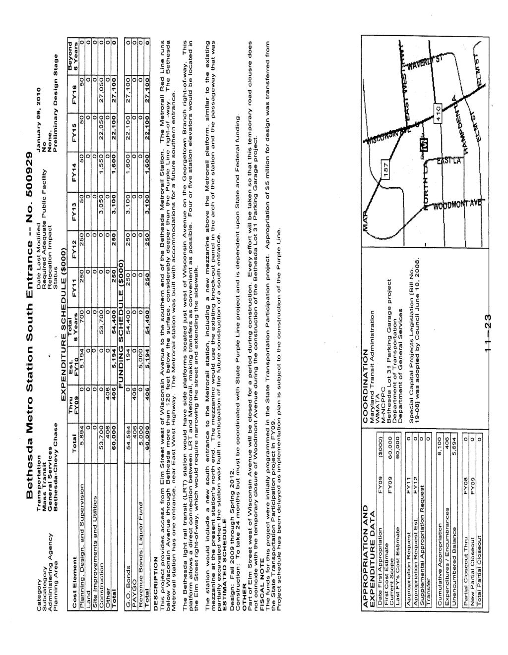
48 Attachment B
49 Attachment C: Summary of Major Points from Capital Crescent Trail Tour on November 3, 2011 Discussions at Bethesda: Tunnel: o The vertical clearance for the trail is between 8 9 ft in the tunnel. o The paved slopes under Wisconsin Ave are not part of the structure of the building. o The costs and risks in the tunnel without the trail would be much less, but MTA does not know how much less. o CSX provided a 32 ft high easement under the Apex. o The trail has to be boxed because of the transitway. o The trail would be about 10 ft above existing grade. o The access points to the trail in the tunnel are at Woodmont Plaza, the Purple Line Station just west of Wisconsin Ave, and Elm Street Park. o Security will be addressed by lighting and call boxes. Lighting o Capital Costs If lights are spaced every 70 ft, the cost is $3.1 million. If lights are spaced every 50 ft, the cost is $7.3 million. o Operational/maintenance costs MTA does not have any cost estimates on these costs Emergency call boxes o The cost of call boxes was developed based on an assumed spacing of every ¼ mile and at key locations. o The cost for the entire trail between Bethesda and Silver Spring is estimated to be $400,000. Landscaping o MCDOT will have the responsibility to maintain landscaping and trail. o Landscaping along the trail between the trail and the county will cost about $1.2 million. o Landscaping at 12 trail connections will cost about $400,000. Benches will cost about $100,000 Security o Security will be County responsibility o The County has not yet estimated the cost Who will build the trail? o MTA will design/build and will turn it over to the County Surface Trail o County CIP Street Park provided by Aruna 47 th Street is owned by the Town of Chevy Chase DOT proposed a shared use path along Willow Ave to 47 th Street, but this was rejected. DOT proposed contra flow bike lane on 47 th St, but this was also rejected. o County is looking at a premium surface trail along the north side of Bethesda Ave; want to maintain existing trees and brick sidewalks. Under the above proposal, on street parking 1
50 Attachment C: Summary of Major Points from Capital Crescent Trail Tour on November 3, 2011 o along the north side will be eliminated as there will be no need to provide on street parking with the Lot 31/31A development and its garage. JBG submitted a development application for Woodmont East. JBG is looking at alternative options to accommodate the trail. Discussions at Rock Creek Park Discussion points: o The Facility Plan for the Capital Crescent and Metropolitan Branch Trails (M NCPPC, 2001) identifies both the Susanna Lane Connector and the Freyman Drive/Grubb Road Connector as interim until the switchback is built. The street connectors are not intended to be permanent. o If the connectors are recommended to become permanent in lieu of building the switchback, many improvements would be needed to roadways along both routes. Additionally, the connectors should be considered a pair. o The trestle bridge would be replaced by a bridge for the Purple Line and a separate bridge for the Capital Crescent Trail o The new bridge for the Purple Line would be about 10 ft lower than the existing trail bridge elevation and the new trail bridge will be about 10 lower than the new transit bridge o The switchback on the east side of the creek and south side of the transit line is recommended by both the 2001 Facility Plan for the Metropolitan and Capital Crescent Trails and the 2010 Purple Line Functional Master Plan o Moving the switchback to the west side would result in an additional structure crossing the creek and be difficult to tie in to the Rock Creek trail without realigning the current Rock Creek Trail o Because the parkland for this section of the Rock Creek Stream Valley Park was purchased with federal funds under the Capper Cramton Act, NCPC has review authority o Shifting the switchback on the east side of Rock Creek to the north may result in parkland and wetland impacts, depending on its alignment. Any impacts to parkland, whether the switchback is on the north or south side, would trigger a federal 4f review (transportation impacts to parkland) o There is a smaller switchback at Jones Mill Road to provide trail access for local residents. The trail and the train travel under Jones Mill Road and the switchback brings trail users back to street level. 2
51 Attachment D
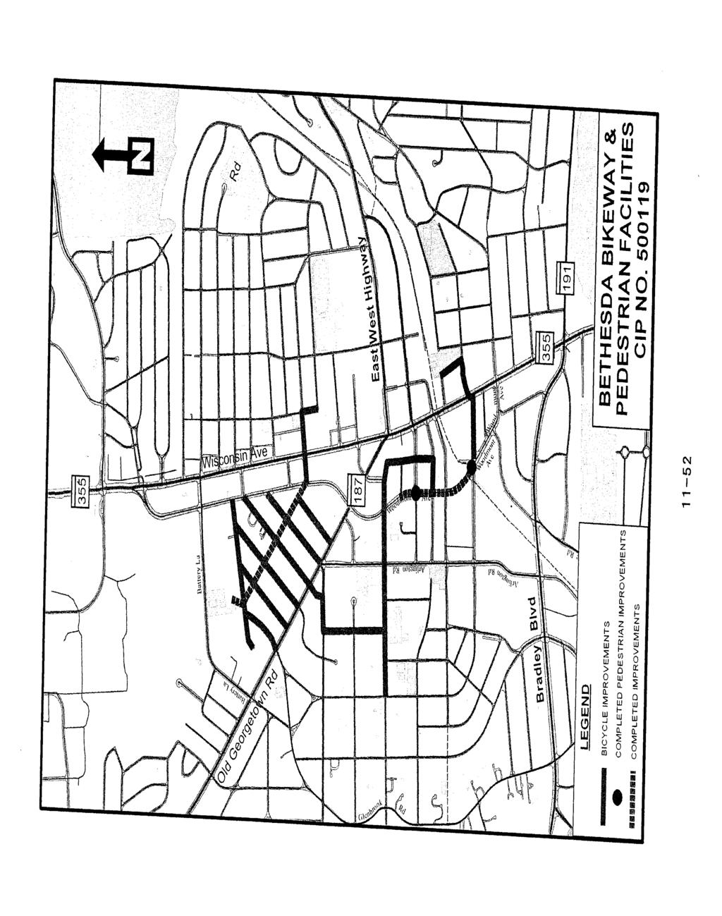
52


53 Attachment E LEGEND PROPOSED STRUCTURES N CAPITAL CRESCENT TRAIL ROCK CREEK TRAIL EXISTING RIGHT-OF-WAY / PROPERTY LINES PURPLE LINE MAINLINE PROPOSED RETAINING WALL PURPLE LINE YARD/SHOP TRACK PROPOSED NOISE WALL EXISTING ROCK CREEK TRAIL POSSIBLE PROPOSED CONNECTIONS TO ROCK CREEK TRAIL EXISTING ROUTE TO ROCK CREEK TRAIL 1 COUNTY BUS FACILITY SUSANNA L A JONE S MI LL R D WALNUT HI LL RD SHARED USE PATH/SIDEWALK AND MAINTENANCE YARD CAPITAL CRESCENT TRAIL LY ER I BR JONES BRI DGE RD ROCK CREEK PARK SUSANN A LA RETAINING WALL 4 CT BR OO KV I LL E 2 C O Q U E LI N RD P K W Y WB TRACK TRACKS DR T LE M HA NOISE WALL D R PL HAM LET PL 3 NA VA RR E RETAINING WALL / R D DR N MA EY R F G R UB B T E R R A C E EB TRACK DR YARD/SHOP DO NN YB RO OK PURPLE LINE FA RR EL L ROCK CREEK PARK D R PURPLE LINE ROC K C REE K NGDELL PL SPRI LL RD JONES MI N I EL QU CO P L COQUE LI N TER R TE WOODBROOK LA P R E S T O N SCALE: 1" = 300 CONTRACT NO. PURPLE LINE DRAFT WORK-IN-PROGRESS MARYLAND DEPARTMENT OF TRANSPORTATION DRAWING NO. Maryland DATE:OCTOBER 2011 PLAN SHEET SCALE:AS SHOWN SHEET NO. 2 OF 2 $DATE$ RCP-01 ROCK CREEK TRAIL CONNECTION OPTIONS ADMINISTRATION LEL$ $FI MARYLAND TRANSIT 1042 LIGHT RAIL STUDY INFORMATION SHOWN SHALL BE USED FOR GENERAL PLANNING /INFORMATION ONLY AND IS SUBJECT TO CHANGE DURING PRELIMINARY ENGINEERING

54 Attachment F. Why Freyman Dr./Grubb Rd. and Susanna La. connectors should be consider as a pair Circuitous routes required for trail users making connections using existing streets
7272 WISCONSIN AVENUE LOCAL AREA TRANSPORTATION REVIEW
 7272 LOCAL AREA TRANSPORTATION REVIEW AND TRANSPORTATION POLICY AREA REVIEW MONTGOMERY COUNTY, MARYLAND Submitted on behalf of Carr Properties Prepared by: Wells + Associates, Inc. Submission: July 1,
Georgetown-Lewes Rail/Trail Study. Rail/Trail Study: Cool Spring to Cape Henlopen State Park New Road Extension (House Resolution No.
 Georgetown-Lewes Rail/Trail Study Rail/Trail Study: Cool Spring to Cape Henlopen State Park New Road Extension (House Resolution No. 47) August 22, 2011 Presentation Outline Background Benefits Statewide
purple line F u n c t i o n a l P l a n
 Approved and Adopted September 2010 purple line F u n c t i o n a l P l a n Montgomery County Planning Department The Maryland-National Capital Park and Planning Commission P u r p l e L i n e F u n c
Maryland Transit Administration. Master Plan Alignment Trail
 Maryland Transit Administration Master Plan Alignment Trail Master Plan Alignment Byrne Kelly Concept Trail Analysis - North vs. South Trail Access & Crossings Aesthetics Master Plan Alignment Description
Lake Erie Commerce Center Traffic Analysis
 LOCATION: East of NYS Route 5 at Bayview Road Town of Hamburg Erie County, New York PREPARED BY: Wendel Companies 140 John James Audubon Parkway Suite 200 Amherst, New York 14228 January 2012 i ii Table
MONTGOMERY COUNTY PLANNING DEPARTMENT THE MARYLAND-NATIONAL CAPITAL PARK AND PLANNING COMMISSION
 MONTGOMERY COUNTY PLANNING DEPARTMENT THE MARYLAND-NATIONAL CAPITAL PARK AND PLANNING COMMISSION MCPB Item No. Date: 6/23/2016 Lucy V. Barnsley Elementary School Addition, Mandatory Referral MR2016027
A. CONCLUSIONS OF THE FGEIS
 Chapter 11: Traffic and Parking A. CONCLUSIONS OF THE FGEIS The FGEIS found that the Approved Plan will generate a substantial volume of vehicular and pedestrian activity, including an estimated 1,300
Non-Motorized Transportation
 Non-Motorized Transportation Non-motorized facilities are important components to the transportation system. They provide an environmentally-friendly, low-cost mode of travel. Some of the facilities can
AGENDA ITEM 5 D WAKULLA ENVIRONMENTAL INSTITUTE (WEI) TRAIL FEASIBILITY STUDY
 TRAIL FEASIBILITY STUDY") March 19, 2018 AGENDA ITEM 5 D WAKULLA ENVIRONMENTAL INSTITUTE (WEI) TRAIL FEASIBILITY STUDY TYPE OF ITEM: Action STATEMENT OF ISSUE The Wakulla Environmental Institute (WEI) Trail is one of several trails
March 19, 2018 AGENDA ITEM 5 D WAKULLA ENVIRONMENTAL INSTITUTE (WEI) TRAIL FEASIBILITY STUDY TYPE OF ITEM: Action STATEMENT OF ISSUE The Wakulla Environmental Institute (WEI) Trail is one of several trails
Construction Staging Adelaide Street West
 REPORT FOR ACTION Construction Staging Adelaide Street West Date: October 6, 2016 To: Toronto and East York Community Council From: Acting Director, Transportation Services, Toronto and East York District
Bloor Street West Rezoning Application for a Temporary Use By-law Final Report
 STAFF REPORT ACTION REQUIRED 3741 3751 Bloor Street West Rezoning Application for a Temporary Use By-law Final Report Date: June 12, 2007 To: From: Wards: Reference Number: Etobicoke York Community Council
5.1 Traffic and Transportation
 5.1 When it opens in 2009, the Bellevue Nickel Improvement Project will increase the number of vehicles able to travel through the study area, improve travel speeds, and improve safety by reducing the
Pedestrian Safety Review Spadina Avenue
 STAFF REPORT ACTION REQUIRED Pedestrian Safety Review Spadina Avenue Date: October 13, 2015 To: Toronto and East York Community Council From: Director, Transportation Services, Toronto and East York District
Proposed Bicycle Lanes on Yonge Street from Queens Quay to Front Street
 STAFF REPORT ACTION REQUIRED Proposed Bicycle Lanes on Yonge Street from Queens Quay to Front Street Date: March 12, 2007 To: From: Toronto and East York Community Council Director, Transportation Infrastructure
Welcome to the Cross County Trail Public Input Session!
 Welcome to the Cross County Trail Public Input Session! Please sign in on the table below! What are we doing here? Camden County has proposed a bicycle and pedestrian trail spanning across the entire county.
Frequently Asked Questions on the Route 29 Solutions Improvements Projects
 Frequently Asked Questions on the Route 29 Solutions Improvements Projects Background What are the Route 29 Solutions improvement projects? These projects include the Route 29/250 Interchange ( Best Buy
Longmont to Boulder Regional Trail Jay Road Connection DRAFT FINAL REPORT
 Longmont to Boulder Regional Trail Jay Road Connection DRAFT FINAL REPORT December 2018 Project Summary Boulder County, Colorado, in partnership with the City of Boulder, is evaluating options for multi-use
University Region Non-Motorized Plan 2015
 Non-Motorized Transportation Non-motorized facilities are important components to the transportation system. They provide an environmentally-friendly, low-cost mode of travel. Some of the facilities can
Madison Metro Transit System
 Madison Metro Transit System 1101 East Washington Avenue Madison, Wisconsin, 53703 Administrative Office: 608 266 4904 Fax: 608 267 8778 TO: FROM: SUBJECT: Plan Commission Timothy Sobota, Transit Planner,
EXHIBIT 1. BOARD AUTHORIZATION FOR PUBLIC HEARING AND SUBSEQUENT ISSUANCE OF A JOINT DEVELOPMENT SOLICITATION
 EXHIBIT 1. BOARD AUTHORIZATION FOR PUBLIC HEARING AND SUBSEQUENT ISSUANCE OF A JOINT DEVELOPMENT SOLICITATION Washington Metropolitan Area Transit Authority Board Action/Information Summary @Action O Information
Interstate 90 and Mercer Island Mobility Study APRIL Commissioned by. Prepared by
 Interstate 90 and Mercer Island Mobility Study APRIL 2017 Commissioned by Prepared by Interstate 90 and Mercer Island Mobility Study Commissioned by: Sound Transit Prepared by: April 2017 Contents Section
Auburn Trail / Ontario Pathways Trail Connector Feasibility Study Public Information Meeting Wednesday, August 22, 2012
 Auburn Trail / Ontario Pathways Trail Connector Feasibility Study Public Information Meeting Wednesday, August 22, 2012 Purpose of Feasibility Study Purpose Evaluate the feasibility of constructing a multiuse
The Baker/Carver Regional Trail is intended to
 Section V Design Guidance The Baker/Carver Regional Trail is intended to safely accommodate 183,000 annual visits, an array of non-motorized uses, a variety of skill levels, and persons with special needs.
Draft Concept Alternatives Analysis for the Inaugural Airport Program September 2005
 Section 10 Preferred Inaugural Airport Concept 10.0 Introduction The Preferred Inaugural Airport Concept for SSA was developed by adding the preferred support/ancillary facilities selected in Section 9
Blueways: Rivers, lakes, or streams with public access for recreation that includes fishing, nature observation, and opportunities for boating.
 Parks, Open Space and Trails PRINCE WILLIAM COUNTY 2008 COMPREHENSIVE PLAN TRAILS PLAN CONTENTS The components of the trails plan are: Intent Definitions Goals, Policies, and Action Strategies Trails Map
FEASIBILITY CRITERIA
 This chapter describes the methodology and criteria used to evaluate the feasibility of developing trails throughout the study areas. Land availability, habitat sensitivity, roadway crossings and on-street
DEMOGRAPHICS AND EXISTING SERVICE
 EXECUTIVE SUMMARY The Central Corridor light-rail transit (LRT) project will open in 2014 and operate between downtown Minneapolis and downtown St. Paul, serving the University of Minnesota and University
EXECUTIVE SUMMARY FALL Introduction. Findings
 EXECUTIVE SUMMARY FALL 2004 Introduction Trails are one of the most popular and highly desirable recreational resources in communities of all sizes throughout the country. In addition to providing a safe
12, 14 and 16 York Street - Amendments to Section 16 Agreement and Road Closure Authorization
 REPORT FOR ACTION 12, 14 and 16 York Street - Amendments to Section 16 Agreement and Road Closure Authorization Date: April 27, 2018 To: Toronto and East York Community Council From: Senior Strategic Director,
McLean Citizens Association Transportation Committee Project Briefing
 McLean Citizens Association Transportation Committee Project Briefing November 10, 2015 Project Map 2 Project Context Only Interstate in the Country limited to HOV only traffic during rush hours Stoplight
Crystal City Station Improvements. Project Overview. Table 2: North Entrance. Table 1: South Entrance. 20th St. S 18th St. S.
 Table 1: South Entrance Table 2: North Entrance 20th St. S 18th St. S Proposed Second Entrance Crystal Drive Existing Station Location Platform Future 4 th Track Future New Airport Connection (by others)
Washington Metropolitan Area Transit Authority Services Utilization Study
 Washington Metropolitan Area Transit Authority Services Utilization Study Maryland House Bill 300 Table of Contents Page 2 Executive Summary Slide 3 Notes Slide 4 Metro Systemwide Fact Sheet Slide 5 How
9 CONSTRUCTION OF BATHURST STREET FROM GREEN LANE WEST TO SOUTH OF HIGHWAY 11, TOWN OF EAST GWILLIMBURY AND TOWNSHIP OF KING
 Clause No. 9 in Report No. 9 of Committee of the Whole was adopted, without amendment, by the Council of The Regional Municipality of York at its meeting held on May 15, 2014. 9 CONSTRUCTION OF BATHURST
Other Principle Arterials Minor Arterial Major Collector Minor Collector Local
 CHAPTER 10 TRANSPORTATION Introduction The system of public roads in East Pikeland Township is decidedly rural in character. Since the 1984, the road network has remained much the same, with the addition
Route 29 Solutions Projects
 Your guide to the Route 29 Solutions Projects For full details & continued engagement please visit www.route29solutions.org The Route 29 Solutions Package is a $230 million investment into the improvement
Arlington County Board Meeting Project Briefing. October 20, 2015
 Arlington County Board Meeting Project Briefing October 20, 2015 Project Map 2 Project Context Only Interstate in the Country limited to HOV only traffic during rush hours Stoplight at the end of I-66
Site Location and Setting
 Memorandum Date: To: From: Subject: Kristy Le, Gary Black Steve Orem Santa Teresa County Park Historic Area Traffic and Parking Study Hexagon Transportation Consultants, Inc. has completed a traffic and
4. Safety Concerns Potential Short and Medium-Term Improvements
 NH Route 104 Access Management Study Page 19 4. Safety Concerns Potential Short and Medium-Term Improvements Potential safety improvement strategies are listed by priority based on field observations by
City of Durango 5.8 FUNDING TRAILS DEVELOPMENT
 5.8 FUNDING TRAILS DEVELOPMENT The City has been successful in establishing dedicated local funding sources as well as applying for grants to develop the City s trail system, having received nearly $2.4
SECTION 106 ACTIVITIES ANNUAL REPORT
 SECTION 106 ACTIVITIES ANNUAL REPORT FOR THE YEAR ENDING DECEMBER 31, 2011 Metropolitan Washington Airports Authority 1593 Spring Hill Road, Suite 300 Vienna, Virginia 22182 JANUARY 2012 Introduction The
Draft Concept Alternatives Analysis for the Inaugural Airport Program September 2005
 Draft Concept Alternatives Analysis for the Inaugural Airport Program September 2005 Section 3 - Refinement of the Ultimate Airfield Concept Using the Base Concept identified in Section 2, IDOT re-examined
Spencer Environmental Appendix A: Alternative Analysis for Construction Access Route
 Spencer Environmental Appendix A: Alternative Analysis for Construction Access Route February 2015 Valley ine-stage 1 RT EISA Update FINA REPORT Page A1 Memorandum AECOM ConnectEd Transit Partnership 10235
Silver Line Operating Plan
 Customer Service and Operations Committee Information Item IV-A December 6, 2012 Silver Line Operating Plan Washington Metropolitan Area Transit Authority Board Action/Information Summary Action Information
1 PROJECT STATUS UPDATE 2 ND CONCESSION FROM BRISTOL ROAD TO DOANE ROAD TOWNS OF EAST GWILLIMBURY AND NEWMARKET
 Report No. 3 of the Regional Council Meeting of March 28, 2013 1 PROJECT STATUS UPDATE 2 ND CONCESSION FROM BRISTOL ROAD TO DOANE ROAD TOWNS OF EAST GWILLIMBURY AND NEWMARKET The recommends: 1. Receipt
3. COLTA / HUGA CONNECTIONS - PRELIMINARY
 9 3. COLTA / HUGA CONNECTIONS - PRELIMINARY 3.1 COLTA The Chain of Lakes Trail Association (COLTA) trail, formerly identified as the Chester Spur Line, was completed and opened for use in June 2011. The
APPENDIX H MILESTONE 2 TRAFFIC OPERATIONS ANALYSIS OF THE AT-GRADE CROSSINGS
 Draft Environmental Impact Statement/Environment Impact Report Appendix H Milestone 2 Traffic Operations Analysis of the At-Grade Crossings APPENDIX H MILESTONE 2 TRAFFIC OPERATIONS ANALYSIS OF THE AT-GRADE
MONTGOMERY COUNTY PLANNING DEPARTMENT THE MARYLAND-NATIONAL CAPITAL PARK AND PLANNING COMMISSION
 MONTGOMERY COUNTY PLANNING DEPARTMENT THE MARYLAND-NATIONAL CAPITAL PARK AND PLANNING COMMISSION Three Sisters Road: Abandonment No. AB740 MCPB Item No. 11 Date: 5-1-14 Katherine Holt, Senior Planner,
PREFACE. Service frequency; Hours of service; Service coverage; Passenger loading; Reliability, and Transit vs. auto travel time.
 PREFACE The Florida Department of Transportation (FDOT) has embarked upon a statewide evaluation of transit system performance. The outcome of this evaluation is a benchmark of transit performance that
Appendix 4.1 L. No-Build Project Descriptions
 Appendix 4.1 L No-Build Project Descriptions No-Build Projects New Bedford A new traffic signal system was installed and activated in early 2009 at the intersection of King s Highway and Mount Pleasant
SAN FRANCISCO MUNICIPAL TRANSPORTATION AGENCY
 THIS PRINT COVERS CALENDAR ITEM NO. : 10.4 DIVISION: Sustainable Streets BRIEF DESCRIPTION: SAN FRANCISCO MUNICIPAL TRANSPORTATION AGENCY Approving various parking and traffic modifications associated
Preliminary Findings of Proposed Alternative
 Preliminary Findings of Proposed Alternative The attached drawing provides a schematic layout of the proposed alternative that will be discussed on July 27, 2010. A full report will follow and should be
Appendix 3. Greenway Design Standards. The Whitemarsh Township Greenway Plan
 Appendix 3 Greenway Design Standards This chapter discusses two design standards for the greenway types discussed above. First, trail design standards are presented together with trailhead facilities and
Figure 1: Little Dry Creek Trail Crossing
 Figure 1: Little Dry Creek Trail Crossing Figure 2: Little Dry Creek Trail Crossing Northwest Rail Environmental Evaluation Temporary Trail Detour Concurrence Form Adams County, Little Dry Creek Trail
Resolution No.: Introduced: July 24, 2018 Adopted: July 24, 2018
 Resolution No.: 18-1215 Introduced: July 24, 2018 Adopted: July 24, 2018 COUNTY COUNCIL FOR MONTGOMERY COUNTY, MARYLAND SITTING AS THE DISTRICT COUNCIL FOR THAT PORTION OF THE MARYLAND-WASHINGTON REGIONAL
Trail # NW Tuesday, June DESIGN. Provide an Review the Provide an. Project Goals: System system. wayfinding
 I. Welcome / Introductions Bethany Creek Trail #2 Segment 3 Neighborhood Meeting #1 Bethany Presbyterian Church 15505 NW Springville Road, Portland, OR 97229 Tuesday, June 26, 2018 @ 6:00PM Meeting Minutes
Community Development Committee
 C Community Development Committee For the Metropolitan Council meeting of October 31, 2012 Committee Report Item:2012-316 ADVISORY INFORMATION October 16, 2012 Date Prepared: Subject: Intercity Regional
Becker County Trail Routing Feasibility Study
 2016 Becker County Trail Routing Feasibility Study CONNECTING DETROIT MOUNTAIN AND MOUNTAIN VIEW RECREATIONAL AREA TO THE HEARTLAND TRAIL BECKER COUNTY ULTEIG ENGINEERS Contents Acknowledgements...2 INTRODUCTION...3
TABLE OF CONTENTS. Coral Springs Charter High School and Middle School Job No Page 2
 Job No. 15-019 Page 2 TABLE OF CONTENTS 1.0 INTRODUCTION... 4 2.0 EXISTING CONDITIONS... 5 3.0 TRAFFIC GENERATION... 7 4.0 TRIP DISTRIBUTION... 8 5.0 FUTURE CONDITIONS... 8 6.0 SITE ACCESS...13 7.0 CONCLUSION...13
Attachment No. 20 RRLRT No. 1. Committee. Busway Grade Crossings STATUS/DATE OF ACTION
 Attachment No. 20 RRLRT No. 1 TECHNICAL COMMITTEE: Railroad / Light Rail Transit Technical Committee TOPIC: Busway Grade Crossings STATUS/DATE OF ACTION RRLRT TC Draft: 06/23/2011 RRLRT TC Approval: 06/27/2014
Construction Staging Area Blue Jays Way (357 King Street West)
") REPORT FOR ACTION Construction Staging Area Blue Jays Way (357 King Street West) Date: June 8, 2018. To: Toronto and East York Community Council From: Acting Director, Transportation Services, Toronto
REPORT FOR ACTION Construction Staging Area Blue Jays Way (357 King Street West) Date: June 8, 2018. To: Toronto and East York Community Council From: Acting Director, Transportation Services, Toronto
Chapter 4.0 Alternatives Analysis
 Chapter 4.0 Alternatives Analysis Chapter 1 accumulated the baseline of existing airport data, Chapter 2 presented the outlook for the future in terms of operational activity, Chapter 3 defined the facilities
Section 106 Update Memo #1 Attachment D. Traffic Diversion & APE Expansion Methodology & Maps
 Section 106 Update Memo #1 Attachment D Traffic Diversion & APE Expansion Methodology & Maps I-65/I-70 North Split Interchange Reconstruction Project (Des. Nos. 1592385 & 1600808) Traffic Diversion and
Parking Amendments - Bay Street, between Harbour Street and Queens Quay West (York Street, Bay Street, and Yonge Street Ramp Removal)
") REPORT FOR ACTION between Harbour Street and Queens Quay West (York Street, Bay Street, and Yonge Street Ramp Removal) Date: October 26, 2017 To: Toronto and East York Community Council From: Acting Director,
REPORT FOR ACTION between Harbour Street and Queens Quay West (York Street, Bay Street, and Yonge Street Ramp Removal) Date: October 26, 2017 To: Toronto and East York Community Council From: Acting Director,
8 CROSS-BOUNDARY AGREEMENT WITH BRAMPTON TRANSIT
 8 CROSS-BOUNDARY AGREEMENT WITH BRAMPTON TRANSIT The Transportation Services Committee recommends the adoption of the recommendations contained in the following report dated May 27, 2010, from the Commissioner
3.0 LEARNING FROM CHATHAM-KENT S CITIZENS
 3.0 LEARNING FROM CHATHAM-KENT S CITIZENS An important aspect in developing the Chatham-Kent Trails Master Plan was to obtain input from stakeholders and the general public. Throughout the course of the
Tallahassee-St. Marks Historic Railroad Trail
 Revitalizing a Historic Trail Designated as a National Recreation Trail, the 16-mile Tallahassee-St. Marks Historic Railroad Trail has been enjoyed by countless bicyclists, runners, and outdoor enthusiasts
MEMORANDUM. Lynn Hayes LSA Associates, Inc.
 MEMORANDUM To: Lynn Hayes LSA Associates, Inc. Date: May 5, 217 From: Zawwar Saiyed, P.E., Senior Transportation Engineer Justin Tucker, Transportation Engineer I Linscott, Law & Greenspan, Engineers LLG
Traffic Management Plan 2018
 Traffic Management Plan 2018 Jesuit College Preparatory School of Dallas Amendment to Planned Development No. 353 Dallas, Texas June 6, 2018 Prepared for Jesuit College Preparatory School of Dallas Prepared
Citrus Heights Creek Corridor Trail Project Trail Advisory Group Field Trip #2 September 11, :00 11:00 am Trellis Hall, Citrus Heights
 September 11, 2013 9:00 11:00 am Trellis Hall, Citrus Heights Project Overview The City of Citrus Heights is studying the feasibility of establishing a multi use trail system within the City s 26 miles
MEMORANDUM. for HOV Monitoring on I-93 North and the Southeast Expressway, Boston Region MPO, November, 2011.
 MEMORANDUM Date: January 12, 2012 To: Congestion Management Process Files From: Seth Asante, Ryan Hicks, and Efi Pagitsas MPO Staff Re: Historical Trends: Travel Times and Vehicle Occupancy Levels for
As the Toronto Transit Commission (TTC) operates a transit service on Bay Street, City Council approval of this report is required.
 operates a transit service on Bay Street, City Council approval of this report is required.") REPORT FOR ACTION Construction Staging Area - 81 Bay Street Date: December 11, 2017 To: Toronto and East York, Community Council From: Acting Director, Transportation Services Toronto and East York District
REPORT FOR ACTION Construction Staging Area - 81 Bay Street Date: December 11, 2017 To: Toronto and East York, Community Council From: Acting Director, Transportation Services Toronto and East York District
Rural Rustic Road Program
 Virginia Department of Transportation s Rural Rustic Road Program Prepared by the Local Assistance Division Virginia Department of Transportation 1401 East Broad Street Richmond, Virginia 23219 Michael
user s guide to Transportation Improvements in Astoria Planning Efforts outside Astoria for more information, contact:
 The Miles Crossing/ Jeffers Garden transportation plan (underway), will identify needed improvements to the Warrenton Astoria Highway and local street improvements to serve expected growth in the Miles
Union Station Queens Quay Transit Link Study
 Welcome Union Station in 1899. Image: City of Toronto Archives Union Station today. Image: Camil Rosiak Activity along Queens Quay. Image: Waterfront Toronto For more information or to comment, visit toronto.ca/waterfronttransit
Stage 2 ION: Light Rail Transit (LRT) from Kitchener to Cambridge
 from Kitchener to Cambridge") Stage 2 ION: Light Rail Transit (LRT) from Kitchener to Cambridge Public Consultation Centre (PCC) No. 3 Please Sign-in Cambridge City Hall November 21, 2017 2:00 to 8:00pm Preston Memorial Auditorium
Stage 2 ION: Light Rail Transit (LRT) from Kitchener to Cambridge Public Consultation Centre (PCC) No. 3 Please Sign-in Cambridge City Hall November 21, 2017 2:00 to 8:00pm Preston Memorial Auditorium
Arvidson, Adam R. Adam,
 Arvidson, Adam R. From: Andrew Hestness Sent: Wednesday, May 18, 2016 5:39 PM To: Arvidson, Adam R. Cc: Renee Spillum; Schroeder, Michael Subject: RE: Park Dedication Attachments: FranklinPlan - Bystrom
Business Item No
 Metropolitan Parks and Open Space Commission Meeting date: February 6, 2018 For the Community Development Committee meeting of February 20, 2018 For the Metropolitan Council meeting of February 28, 2018
Memorandum. Roger Millar, Secretary of Transportation. Date: April 5, Interstate 90 Operations and Mercer Island Mobility
 Memorandum To: From: The Honorable Dow Constantine, King County Executive; The Honorable Ed Murray, City of Seattle Mayor; The Honorable Bruce Bassett, City of Mercer Island Mayor; The Honorable John Stokes,
DEVELOPMENT OF TOE MIDFIELD TERMINAL IROJECT CAPACITY ENHANCEMENT REPORT DEPARTMENT OF AVIATION TOM FOERSTER CHAIRMAN BARBARA HAFER COMMISSIONER
 PETE FLAHERTY COMMISSIONER TOM FOERSTER CHAIRMAN DEPARTMENT OF AVIATION BARBARA HAFER COMMISSIONER STEPHEN A. GEORGE DIRECTOR ROOM M 134, TERMINAL BUILDING GREATER PITTSBURGH INTERNATIONAL AIRPORT PITTSBURGH,
Trail Use in the N.C. Museum of Art Park:
 Trail Use in the N.C. Museum of Art Park: New Connections, New Visitors Jacqueline MacDonald Gibson, PhD Daniel Rodriguez, PhD Taylor Dennerlein, MSEE, MCRP, EIT Jill Mead, MPH Evan Comen University of
Community Development
 Community Development City & Borough of Juneau Community Development 155 S. Seward Street Juneau, AK 99801 (907) 586 0715 Phone (907) 586 4529 Fax DATE: February 11, 2016 TO: FROM: Planning Commission
HIGHWAY RAIL GRADE CROSSING CONSOLIDATION PROGRAM
 HIGHWAY RAIL GRADE CROSSING CONSOLIDATION PROGRAM To decrease unnecessary train traffic exposure to life and property, promote public safety, and improve traffic conditions, the Texas Department of Transportation
COASTAL CONSERVANCY. Staff Recommendation December 2, 2004 COYOTE HELLYER COUNTY PARK BAY AREA RIDGE TRAIL
 COASTAL CONSERVANCY Staff Recommendation December 2, 2004 COYOTE HELLYER COUNTY PARK BAY AREA RIDGE TRAIL File No. 04-057 Project Manager: Amy Hutzel RECOMMENDED ACTION: Authorization to disburse up to
PURPOSE AND NEED (CONCURRENCE POINT 1) NEW CANADA ROAD PROJECT FROM STATE ROUTE 1 (U.S. HIGHWAY 70) TO U.S. INTERSTATE 40
 NEW CANADA ROAD PROJECT FROM STATE ROUTE 1 (U.S. HIGHWAY 70) TO U.S. INTERSTATE 40") PURPOSE AND NEED (CONCURRENCE POINT 1) NEW CANADA ROAD PROJECT FROM STATE ROUTE 1 (U.S. HIGHWAY 70) TO U.S. INTERSTATE 40 Project Description The primary purpose of this project is to improve the major
PURPOSE AND NEED (CONCURRENCE POINT 1) NEW CANADA ROAD PROJECT FROM STATE ROUTE 1 (U.S. HIGHWAY 70) TO U.S. INTERSTATE 40 Project Description The primary purpose of this project is to improve the major
CONGESTION REPORT 1 st Quarter 2018
 CONGESTION REPORT 1 st Quarter 2018 A quarterly update of the National Capital Region s traffic congestion, travel time reliability, top-10 bottlenecks and featured spotlight Feburary 11, 2019 ABOUT TPB
Railroad Safety Trail
 2.1 INTRODUCTION AND PROJECT SETTING 2.1 Introduction & Project Setting Introduction This study is the result of a directed effort on the part of the City of San Luis Obispo to carry out previously established
Re: Item 7- PR13.{)35 - Region of York Municipal Parbtership Grant Application and Approval of Two Grade-Separated Underpasses
35 - Region of York Municipal Parbtership Grant Application and Approval of Two Grade-Separated Underpasses") Office of the Clerk John D. Leach Director of Customer and Legislative Servicesffown Clerk 905-727-3123 ext. 4771 jleach@aurora.ca Town of Aurora 100 John West Way, Box 1000 Aurora, ON L4G 6J1 August 14,
Office of the Clerk John D. Leach Director of Customer and Legislative Servicesffown Clerk 905-727-3123 ext. 4771 jleach@aurora.ca Town of Aurora 100 John West Way, Box 1000 Aurora, ON L4G 6J1 August 14,
Blackburn Road Blackburn Level Crossing Removal. Frequently Asked Questions August 2014 GENERAL
 Frequently Asked Questions August 2014 Blackburn Road Blackburn Level Crossing Removal GENERAL What is the project? The Victorian Government has committed to eliminating a number of the busiest level crossings
MORGAN CREEK GREENWAY Final Report APPENDICES
 APPENDICES MORGAN CREEK GREENWAY Appendix A Photos of Existing Conditions in Trail Corridor Photos of existing conditions Main trail corridor - February 2009 Photos of existing conditions south bank Morgan
BOARD OF SUPERVISORS AND VIRGINIA DEPARTMENT OF TRANSPORTATION JOINT PUBLIC HEARING
 BOARD OF SUPERVISORS AND VIRGINIA DEPARTMENT OF TRANSPORTATION JOINT PUBLIC HEARING Date of Hearing: September 14, 2016 #1 SUBJECT: ELECTION DISTRICT: Proposed FY2017-FY2022 Secondary Road Six-Year Plan
CHAPTER 4: ALTERNATIVES
 MSP Long Term Comprehensive Plan Update Metropolitan Airports Commission 4.1 INTRODUCTION CHAPTER 4: ALTERNATIVES Several alternatives were developed and evaluated based on their capability to meet the
ANCLOTE COASTAL TRAIL ALTERNATIVES ANALYSIS STUDY
 ANCLOTE COASTAL TRAIL ALTERNATIVES ANALYSIS STUDY PASCO COUNTY MPO JULY 2015 PROJECT OVERVIEW... INTRODUCTION EXECUTIVE SUMMARY CONTEXT... TAMPA BAY AREA, PINELLAS, & PASCO COUNTY S MULTI-USE TRAIL PLANS
Chapter 6: POLICY AND PROCEDURE RECOMMENDATIONS
 Chapter 6 POLICY AND PROCEDURE RECOMMENDATIONS FOR SRRA Below are seven policy elements that should be considered for adoption by the Southwest Regional Recreation Authority of Virginia: 1. Develop strategies
LUDWIG RD. SUBDIVISION PROJECT TRAFFIC IMPACT ANALYSIS
 LUDWIG RD. SUBDIVISION PROJECT TRAFFIC IMPACT ANALYSIS Prepared for Skip Coddington GSC Development, Inc PO Box 1623 Woodinville WA 9872 Prepared by 1141 NE 124 th St., #59 Kirkland, WA 9834 425.522.4118
Palm Beach County Traffic Report July 13 through July 20, 2012
 For Immediate Release July 13, 2012 Meredith Cruz, (561) 641-6440 mcruz@corradino.com Palm Beach County Traffic Report July 13 through July 20, 2012 Palm Beach County Palm Beach County traffic will be
TRANSPORTATION ELEMENT
 Transportation TRANSPORTATION ELEMENT Data, Inventory, and Analysis Prepared by Contents 1.0 INTRODUCTION... 1 2.0 EXISTING CONDITIONS... 1 2.1 Roadways... 1 2.1.1 Jurisdiction... 1 2.1.2 Functional Classification...
Table of Contents. List of Tables
 Table of Contents 1. Introduction... 1 2. Service Recommendations... 1 A. Extend Service on Fort Belvoir to New Post Exchange/Commissary Complex... 1 B. Improve Service Frequencies on Sunday from Current
Sheraton Centre Toronto Hotel Motor Court - Relocation of Taxi Facilities
 Sheraton Centre Toronto Hotel Motor Court - Relocation of Taxi Facilities (City Council on July 4, 5 and 6, 2000, adopted the following recommendation: It is recommended that the report dated June 6, 2000,
Gold Coast. Rapid Transit. Chapter twelve Social impact. Chapter content
 Gold Coast Rapid Transit Chapter twelve Social impact Chapter content Social impact assessment process...235 Existing community profile...237 Consultation...238 Social impacts and mitigation strategies...239
The Chu property is a 6.57 acre parcel located in the Town of Superior on the west side of McCaslin Boulevard. In 2014, the Town of Superior acquired
 1 The Chu property is a 6.57 acre parcel located in the Town of Superior on the west side of McCaslin Boulevard. In 2014, the Town of Superior acquired the Chu property for open space with a contribution