THE SME AVALANCHE TRAGEDY OF JANUARY 20, 2003: A SUMMARY OF THE DATA. Dick Penniman* Snowbridge Associates Frank Baumann Baumann Engineering
|
|
|
- Malcolm Jennings
- 6 years ago
- Views:
Transcription
1 THE SME AVALANCHE TRAGEDY OF JANUARY 20, 2003: A SUMMARY OF THE DATA Dick Penniman* Snowbridge Associates Frank Baumann Baumann Engineering ABSTRACT: On January 20, 2003 guided skiers and snowboarders with the Selkirk Mountain Experience (SME) Company climbed a 310 meter long, avalanche slope on Tumbledown Mountain in the Durrand Glacier area in the Northern Selkirks of British Columbia. In switch back fashion two groups of 10 and 11 each followed one after the other. The individuals within each group were told to space themselves approximately five feet apart. As several members of the lead group reached a convex roll at the top of the slope, a large avalanche released catching thirteen people below. Seven were killed. This paper presents the significant terrain, snowpack, weather, and human factor data that contributed to this tragic avalanche event. Keywords: couloir, wind-loading, weak layer, terrain risk 1. INTRODUCTION On January 20, 2003, seven ski tourers, under the leadership of Reudi Beglinger, a Swiss-trained mountain guide and member of the Association of Canadian Mountain Guides (ACMG) and the Canadian Avalanche Association (CAA), died when they were buried by an avalanche in the Durrand Glacier area, 35 km north northeast of Revelstoke, B.C., Canada (Figure 1). The victims were part of a group of 21 skiers that had departed that morning from the Durrand Chalet, a remote, helicopteraccessed mountain lodge located at the headwaters of Cairns Creek, on the west side of the Selkirk Mountains, and owned by Ruedi Beglinger s company, Selkirk Mountain Experience. The La Traviata couloir, where the fatal avalanche occurred, is a 310 meter long, shallow, steep, wind-loaded gully with a 37 starting zone. For weeks prior to the avalanche, warnings of the presence of a widespread, persistent weak layer of faceted crystals in the winter snowpack and an overlying snow slab that could produce large avalanches, were being widely reported in public bulletins issued by the Canadian Avalanche Association and the Avalanche Control Section of Parks Canada at Rogers Pass. The Canadian Avalanche Association s private Corresponding Author Address: Dick Penniman, Snowbridge Associates, P.O. Box 34004, Truckee, California tel: ; fax ; dpenniman@snowbridge.org km Vancouver DURRAND GLACIER Revelstoke Figure 1: Location of the accident site near Revelstoke, British Columbia, Canada. data exchange system (Infoex) was also warning of the hazard. 2. CHRONOLOGY OF EVENTS 2.1 The Ascent Route At about 8:00 am on January 20, 2003, two groups of skiers (12 led by SME owner, Ruedi Beglinger, and a second group of 7 skiers led by assistant guide Ken Wylie), left the Durrand Chalet (1940 m elevation) and headed north 520
, they put on climbing skins and then ski toured up across the south face of Tumbledown Mountain, heading for a relatively low-angled wooded area at")
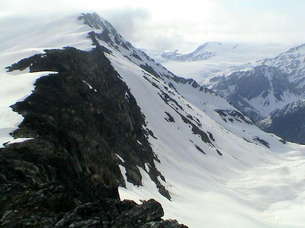
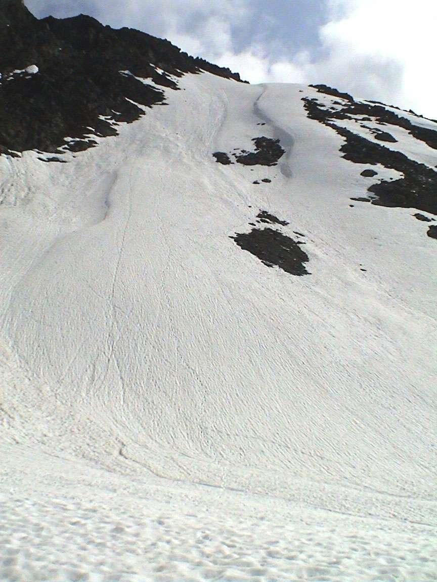
2 down into the headwaters of Cairns Creek. At the bottom of the valley (about 1620 m), they put on climbing skins and then ski toured up across the south face of Tumbledown Mountain, heading for a relatively low-angled wooded area at timberline known as Swiss Meadows (about 1900 m). Both the headwaters of Cairns Creek, and especially the south face of Tumbledown Mountain, are areas where the lack of trees and the terrain configuration indicates that frequent snow avalanche activity occurs (Figure 2). Tumbledown Mountain Glarona Peak Fronalp Peak Fatal Avalanche June 19, 2003 Figure 2: Route taken across the south face of Tumbledown Mountain en route to La Traviata couloir On the route up to Swiss Meadows, according to one of the ski tourers, the group crossed at least one slide track with evidence of recent avalanche activity. From Swiss Meadows, the touring group continued up through relatively gentle-sloping and open terrain at the base of the steeper slopes that go up to the long west ride of Tumbledown Mountain. The ascending route was close enough to the base of the slope that it was subsequently overrun by the avalanches that occurred later that day. At about 2240 meters, the lead group took a rest break near the base of a shallow gully (the La Traviata couloir) that goes up to the west ridge of Tumbledown Mountain. Apparently, the objective up to this point had been to tour up to Fronalp Peak, a small 2500 m high summit near the west end of the Tumbledown west ridge and the normal, low angle ascent route as depicted on the SME Guide Map. At this juncture, however, Ruedi Beglinger made the decision to go up the La Traviata couloir instead. After a short break at the same location, the second group followed on the heels of the first group. The two groups of tourers first traversed across the base of the slope, and then continued up the couloir as far as they could until they were under a group of rock bluffs on the west side. They kick turned and traversed back across the couloir to the rocky ridge on the east side. At this point they continued to zigzag up the couloir, making several more kick turns before they reached the top (Figure 3). According to the Coroner s Report, the skiers were told to stay two meters apart as they ascended the couloir. At the top of the couloir, Ruedi Beglinger, who was well above and ahead of the next ski tourer, exited to the east crossing from deep, 521

3 Durrand Glacier 310 m (1017 feet) 37 upper slope Chalet Uphill track June 19, 2003 Figure 3: Looking east at the approximate route taken up the La Traviata couloir by the SME touring group. wind-deposited snow in the couloir to more shallow, low angled snow to climber s right. Seven other members of his group soon followed him onto the shallower snow. 2.3 The Avalanche At about 10:45 am according to mountain guide and avalanche instructor Larry Stanier in his technical report to the Coroner, the seven ski tourers who were above the La Traviata couloir heard a sudden whumpf and noticed a shift of the snowpack. Then a slab avalanche estimated to be about 50 m wide, 400 m long, and 50 cm deep moved down the approximately 39 slope to the southeast of where this group was located. At the bottom of the slope, it spread out across flat terrain, crossing the uphill track made by the group earlier. At about the same time, the Report states that a second smaller slide started lower down on the slope, in rocky terrain between the first avalanche and the La Traviata couloir where all of the remaining skiers were ascending. A crack also ran across the entire top of the La Traviata couloir to the southwest. Where it crossed through wind-deposited snow in the gully, it broke out a 65-meter wide snow slab that varied from 63 cm to 260 cm in depth with an average depth of 150 cm. The exact sequence of the three avalanches is not known. The Coroner s Report suggests that the southeasterly slide occurred first, but it is possible that all three slides occurred at about the same time. It is also not certain where the fatal avalanche was triggered. Although the Coroner s Report stated that it was started by the first seven ski tourers above the La Traviata couloir, it is also possible that it was started in 522
4 the couloir itself by the weight of the rest of the ascending party. According to the Coroner s Report the dimensions of the avalanche debris the La Traviata couloir was about 185 meters long across the slope, and about 85 meters wide, with an apparent depth of about 300 cm. If these figures are correct, the volume of the debris totaled about 47,000 cubic meters. Using a density of 0.4 tonnes per cubic meter, the weight of the debris would have totaled approximately 19,000 tonnes. 2.3 The Rescue Ruedi Beglinger was above the La Traviata couloir and some distance off to the east side when the avalanches occurred. It is not possible to determine his exact position, but most likely he was about 70 meters north northeast of the couloir avalanche crown line. One skier estimated that he was about 20 meters from the next person in the track, and that person was about 50 meters up beyond the crown line. From the area where Beglinger stood, he could not have seen the avalanche crown or look down the couloir and see the avalanche path or even the debris where his clients were buried. There was a short delay as word reached him of what had happened. Once the realization of what had happened was apparent, however, he and the seven other survivors moved quickly down the icy, 37 bed surface to where the victims were buried. Radio communications were attempted to get assistance with the rescue effort. At 11:05 am Selkirk Tangiers Heli-Skiing (STHS) personnel overheard the radio conversations and volunteered to send three guides to help. They were picked up by Selkirk Mountain Helicopters at 11:23 but were unable to land until 11:41 because of bad weather. They arrived too late to help find any but the last victim who was pulled out of the avalanche debris at 11:45. Of the 13 skiers who were caught in the avalanche, six survived and seven died. There is some inconsistency about how many people were totally buried; most likely eight were fully buried, and five were partially buried. Only one of the eight skiers who were totally buried survived; he was found 280 centimeters down in 30 minutes. Those who died were buried from 130 to 280 cm deep. 3. THE TERRAIN The La Traviata couloir where the fatal avalanche occurred is a steep, wind loaded, 310 meter long, shallow gully with a 37 starting zone. It is a classic side-loaded gully with a large fetch to windward. 3.1 Slope Description The La Traviata couloir is a south facing trough-like feature that starts on flat-lying glacial till deposits located at about 2300 m elevation. The base of the couloir consists of a concave talus apron that is about 71 meters long, and is sloped at an average angle of about 27. Above this, the slope is steeper and more uniform and consists of colluvial deposits (scree) that go up for 204 meters at an angle of about 36, and then an additional 36 meters at an average angle of about 37 to a convex roll-over (See Appendix 1). Above the convex rollover at the top of the couloir, the angle of the scree slope decreases slightly to 34 for 26 meters. Above this, the ground consists of broken rock and bluffs that continue up to the ridge crest for 16 meters at an average slope angle of 51. The top of the ridge is located at an elevation of about 2500 meters. The total length of the slope from the ridge crest to the flat valley bottom is about 350 meters with an average slope angle of about High Risk Terrain Features The specific features of this avalanche path that were indicators of high risk terrain are the following: a) The slope steepness. 60% of all avalanches initiate on slopes of between 35 and 40. The starting zone for the La Traviata couloir is 36 to 37. b) Lee slope cross loading. Most avalanches occur on slopes where winds cause snow to accumulate to form dense potentially dangerous snow slabs. The La Traviata couloir is cross-loaded for nearly its entire length and has a large area to windward (the fetch) from which significant amounts of snow can be transported with moderate wind speeds. c) A convex roll at the top. At such places of convex curvature, a snow slab resting on a persistent weak layer would be in tension due to the difference in the rate of 523
5 snow creep above and below the roll. A skier traversing such a place is more likely to trigger a release as compared to a flat or concave slope. On the day of the fatal avalanche, the route taken by Reudi Beglinger and his clients traversed directly into the wind-loaded convex roll at the top of the La Traviata couloir. d) Relatively smooth underlying terrain (no anchors). A smooth, scree-covered slope does not provide any significant anchoring of the snowpack. The La Traviata couloir was such a slope. e) Connectivity to an area of shallow snow. In areas where there is continuous snow cover connecting areas of shallow and deep snow the weight of a person skiing into the shallower snow where faceted snow is more likely to develop can cause a collapse of the weaker faceted snow. This collapse can then propagate to the slope with a deeper snow slab, triggering an avalanche. This is more likely to happen if the snow slab rests on a persistent weak layer such as existed in the Durrand Glacier area at the time of the fatal avalanche. The La Traviata couloir was adjacent to and connected by snow cover to the shallower snow of the fetch and upper bench area. A collapse of the faceted layer in this area could easily propagate to the couloir. f) A sudden transition to flat terrain in the runout. An avalanche path with a sudden transition from steep to flat terrain creates a relatively inefficient flow of avalanche debris in the run out zone. The vast majority of the energy of the avalanche is dissipated at the transition, causing deep accumulations of debris at that point. The likelihood of a deep burial is increased on such slopes when skiers are caught in an avalanche from above. The terrain of the La Traviata couloir had just such a sudden transition at its base where the slope decreased from 27 to nearly 0 over only a few meters. With skiers ascending at various elevations up the couloir, even a small avalanche triggered from above was likely to cause deep burials. 4. THE SNOWPACK In the Coroner s Report a succinct description of the history of the snowpack in the Selkirk Mountains was provided based on data obtained from the Mt. Fidelity remote weather station located at about 1905 meters and some 20 km east of the Durrand Glacier and the Selkirk Mountain Experience (SME) operation area. No formal pre-avalanche snowpack data was available or is known to exist from SME as of this writing. However, snowpack data from the investigation of the crown face of the La Traviata couloir avalanche was available. 4.1 History of the Winter Snowpack in the Selkirk Mountains Winter started in the North Columbia mountains on about November 1, 2002, and by November 19, there were 118 cm of snow on the ground at the Mt. Fidelity study plot. On November 20, 21, and 22, temperatures remained above freezing and significant amounts of rain, and rain mixed with snow at higher elevations fell. On November 23, temperatures dropped, and a melt-freeze crust formed on the surface of the snow. This curst was extremely widespread geographically and was particularly pronounced in the Northern Selkirk Mountains. Temperatures remained cold from November 23 until December 6, when light snow fell and was deposited on the crust. Cold, clear conditions prevailed until December 10, which allowed the light snow to change and develop faceted crystals. When new snow started to fall on December 10, winds were light, which allowed the faceted crystals to remain intact and to be buried by new snow that fell between December 10 and 27 (including 40 cm that fell between December 25 and 27). The preserved faceted layer is believed to have formed the failure plane on which many subsequent avalanches, including the ones in the Durrand Glacier area, ran. 4.2 Snowpack Data at the SME Durrand Chalet SME started operations for the season on December 28, On that date, they reported a total snow depth of 161 cm, including 20 cm of new snow. An additional 11 cm of snow was recorded between December 28, and January 4, 2003, 12 cm between January 12 and 14, and one centimeter of new snow on January 20 (the date of the fatal avalanche). 524
6 On January 20, 2003, the total snow depth at the Durrand Chalet was reported to be 148 cm, indicating that a considerable amount of settlement had taken place since weather and snowpack observation were started on December 28, There is no indication in Larry Stanier s report to the Coroner that standard snow profiles were prepared by SME at the Durrand Chalet study plot, or that any stability tests were done. To date no standard snow profiles from Selkirk Mountain Experience have been forthcoming. There is no indication in the Coroner s Report that SME reviewed any of the publicly available avalanche reports for the North Columbia Mountains. Nor was it reported whether SME discussed snow stability with other nearby operations such as Selkirk Tangiers Heli-Skiing. Therefore, it is not known what, if anything, was done by SME to evaluate snow stability before the group left the Durrand Chalet on the morning of January 20, Public Avalanche Bulletin and Other Warnings of Avalanche Hazard On January 20, 2003 (the day of the fatal avalanche) the Canadian Avalanche Association s Public Avalanche Bulletin for the North Columbia Mountains (which includes the SME operating area) warned of a deep-seated instability in the snowpack. The Bulletin warned that natural avalanches were possible and that skier-triggered avalanches were probable. The overall avalanche hazard rating was Considerable, midway in the five-class hazard scale. The warning associated with this rating stated, Be very cautious in steeper terrain, on lee slopes, or where temperatures are likely to increase. The Bulletin for January 17 to January 20 provided additional snowpack and avalanche information as follows: SNOWPACK: The cm of new snow that fell early in the week continues to settle and bond to the previous surfaces. This new snow has formed wind slab in exposed areas. Moderate to hard shears are still occurring on two surface hoar layers down 70 to 100 cm. Watch for cornices failing with forecasted warm temperatures, particularly as they can be a trigger for a deep instability, which we certainly have this year. AVALANCHES: Several size 1 to 1.5 natural and human triggered avalanches, at tree line and in the alpine, were reported as recent[ly] as Wednesday. These occurrences are now becoming isolated as recent storm snow continues to bond. A few remotely triggered size 2.5 avalanches failed in the Eastern Selkirks, some triggered from over 100 meters away. Widespread whumpfing continues to be observed in all areas. The Bulletin also posted the following advisory: TRAVEL ADVISORY: It is important to remember that this El Nino year is producing a complex and unusual snowpack for the mountains of BC. We have two deeply buried problem layers that are slow to heal and need our continued attention. Be alert for remote triggering and continue to be vigilant about avoiding those tempting big steep alpine faces. Any avalanche triggered on the older weaknesses may propagate extensively into a large and dangerous avalanche event. Be aware of how stresses penetrate deeper into the snowpack as you group up. At Rogers Pass in Glacier National Park, about 30 km from the SME operating area, the Avalanche Control Section of Parks Canada was also warning of Considerable avalanche hazard. Snow profiles from the Avalanche Control Section were also publicly available from both Mt. Fidelity and Mt. MacDonald. In addition to the Public Avalanche Bulletin and the publicly available information from Rogers Pass, the Canadian Avalanche Association s private Information Exchange system (Infoex) provided substantial additional information. SME was not a subscriber to this service, however, and did not have access to this information on the day of the fatal avalanche. The presence of the persistent weak layer of faceted crystals described in both Bulletins and Infoex was noted in the snow profiles dug in the vicinity of the La Traviata couloir area by investigators working after the fatal avalanche. 5. WEATHER The La Traviata couloir faces approximately southwest, and the snow pillows and wind rolls present indicate that it would be wind loaded most heavily by southeasterly winds that blow across the south face of Tumbledown Mountain. 525
7 The snow profiles recorded immediately after the fatal avalanche show that a considerable amount of wind deposition in the La Traviata couloir had occurred. Snow depths of up to 260 cm were found in the couloir (2475 m elevation), while only 148 cm were recorded at the sheltered snow study plot at the Durrand Chalet (1940 m elevation). The Canadian Avalanche Association s Public Bulletin for the North Columbia Mountains (which includes the SME operating area) stated weather conditions between January 17 and 20, 2003 as follows: WEATHER: The strong ridge of high pressure over the south coast and interior BC will persist through Friday and Saturday, bringing mainly clear skies in the alpine and extensive valley fog. The ridge will begin to give way on Sunday. Expect cooler temperatures in the valley and temperatures above freezing in the alpine. Winds will be light to moderate from NW throughout the weekend. According to the Coroner s Report, significant winds (those having velocities of more than 25 km/h) were reported on eight separate occasions between January 1 and 19 on the Infoex system by ski operations in the Northern Selkirks. Moderate winds are those with speeds of between 26 and 40 km/h, and strong winds are those with speeds of greater than 40 km/h. The significant wind events that occurred were on January 2 (strong southwest winds); January 3 (strong south and southwest winds); January 4 (moderate southwest winds); January 7 (strong southwest winds); January 8 (moderate northwest winds); January 12 (moderate west wind); and January 19 (moderate to strong southwest winds). 6. THE HUMAN FACTOR Numerous avalanche books describe basic weather, snowpack, and terrain features that are likely to increase the risk of avalanches. These books also describe basic safe travel techniques that minimize the risk of being caught or killed in an avalanche. These precepts are universal. The following are some of the most common: a) Before heading out into the backcountry, check and heed the advice of public avalanche bulletins and other sources. b) Be aware of the underlying ground surface of potential avalanche slopes and whether terrain features provide any substantial anchoring of the snowpack. c) Track the history of the winter snowpack so that potentially unstable layers or conditions that might cause unusual avalanche activity can be recognized and managed. d) Be extra cautious after storms. Most avalanches occur during or immediately after storm activity, especially if more than 25 cm of snow has fallen in a short period of time, strong winds have been present, there is a rapid rise in temperatures, or other unusual weather or snowpack conditions have occurred. e) Be extra cautious of lingering weak layers caused by early season cold spells. Faceted crystals inhibit the natural strengthening of the snowpack. f) Be wary of wind-loaded lee slopes where winds have caused larger amounts of dense snow to form slabs. Note the size of the windward slope or fetch as compared to the area of wind deposit. A small gully or couloir can be loaded quickly by snow transported from a relatively large fetch even with moderate wind speeds. g) Be wary in areas where stresses in the snowpack may be greater, such as steep slopes greater than 30, convex rolls, and wind loaded slopes. h) Always consider what would happen to a person if a slope does slide. Deep burials can occur in areas of sudden transition such as benches, creek beds, and flat valley bottoms. i) Before considering whether or not to cross a slope, consider the remoteness of the location and whether help is near. Consider safer alternatives if the area is remote. j) If an avalanche slope that may slide must be crossed, a complete stability assessment is critical. All members of the group should check rescue equipment, do up clothing, and assure that a minimum number of people at a time are exposed to the avalanche hazard. Take advantage of islands of safety, move as quickly as safely possible, and be prepared to carry out a rescue should it be necessary. k) Stay away from the base of large avalanche slopes when traveling in the valley bottom. Try to stay out of the 526
8 potential run out zone where possible. Where it is not, move quickly, exposing as few people to the hazard as possible. From the information available, it appears that both the SME guides and the clients ignored nearly all of these precepts. 6. DISCUSSION It is clear from the data that the La Traviata couloir presented high-risk terrain to the SME touring group. Considering the public bulletins that warned of one or more lingering weak layers in the snowpack at isolated locations throughout the Selkirk Mountains, the wisdom of deciding to ascend the La Traviata couloir must be examined critically so as to avoid, if possible, tragedies of this magnitude in the future. Clearly the SME guides did not heed the warning signs or at the very least, did not feel that they were applicable to their group or the La Traviata couloir on January 20, Neither did they feel the need to follow long established precepts in safe winter travel. Placing the weight of as many as 21 closely spaced people on such a slope seems a flagrant violation of the most basic of safe winter travel precepts. Yet one must consider the context within which this tragedy unfolded. Commercial back country operations, whether they be heli-skiing companies or ski touring operations like the Selkirk Mountain Experience must be profitable to survive. There is competition from other companies to consider. Sudden illness, injury, and equipment failure are additional worries. Differences in skill and fitness levels among clients complicate matters further. A high client-to-guide ratio allows the largest number of people to participate in these activities at the lowest possible monetary cost. But with increased group size comes slower movement and a higher risk that if there is a mishap, more people will be affected. Finding a balance between profit and safety is the challenge all backcountry operators face, and it is arguably not an easy one. Another central question that arises from the La Traviata tragedy is what responsibility a client has for his or her own safety while being in a guided group. In unfamiliar terrain, and especially with glacier travel or inclement weather conditions, the client is quite dependent on the guide to select the safest routes. Even were a client to be familiar enough with the terrain to be able to make independent assessments and decisions for personal safety, guides do not normally tolerate any independent action by the clients. From the first author s personal experience, this is especially true of the Selkirk Mountain Experience where the guide s word is law, and if a client falters, he often is quite literally left behind. At least two of the SME clients involved in the fatal avalanche in the La Traviata couloir on January 20, 2003 were former students of avalanche safety courses personally conducted by the first author. They both had been taught and knew the basic precepts of recognizing avalanche terrain and of safe winter travel. Both practiced these precepts successfully in their personal back county endeavors. Yet they both consciously decided to surrender their own decision-making abilities to the SME guides on January 20, One paid for that decision with her life. 7. CONCLUSION As much as one might believe in taking personal responsibility for ones own actions in all circumstances, this is not always possible. A classic example of this fact is found in public transportation. Once one makes the decision to board an airplane (or helicopter) for example, virtually all safety concerns are handed over to the pilots, flight attendants, and the mechanics who serviced it. This is true of trains, buses, boats, and even taxis where passengers consciously or otherwise give the engineers, drivers, and captains significant responsibility for their safety. While it may seem different in a guided ski touring or heli-skiing setting where one is moving under one s own power, it is not. Especially where there may be hidden crevasses or obscured visibility or white-out conditions, the client must place his or her complete trust in the guide to choose safe routes through the terrain and be up to speed on current snowpack conditions and avalanche potential. The technology does not yet exist, however, to monitor and measure the snowpack everywhere and at all times. The mountain snowpack is infinitely variable over time and space and is, by definition, unknowable. What is knowable is the terrain. Nearly always, simple measurements of slope angle, and observations 527
9 of wind-loading and slope configuration can be used to identify and avoid high-risk avalanche terrain. When there is any doubt about the strength of the snowpack, terrain must dictate proper route selection. The CAA and Rogers Pass warnings provided ample doubt about snowpack strength in the SME operating area on January 20, It is clear that the SME guides had not been recording snowpack data for the area of the La Traviata couloir and did not know of (or chose to ignore) the weak layer(s) in the snowpack on that day. But the high-risk nature of the terrain was obvious from even cursory observations. By any standard, choosing to ascend the La Traviata couloir with 21 closely spaced people on that day was a human failure. This avalanche tragedy demonstrates that like anyone, on any given day, at any given time, and for any reason (no matter how grand or trivial) even the best guide may not be paying as much attention to client safety as is necessary. In most cases surrendering one s own decisionmaking abilities to those of the guide is demanded and is arguably the single greatest risk-decision one makes when choosing to partake in commercial, guided outdoor activities. Lessons from the SME avalanche tragedy of January 20, 2003 need to be studied, understood, learned, and passed on to the professional guiding community and to students through avalanche safety courses. Those who participate as clients in guided back-country activities must understand the risks they are choosing to take not only involve avalanche terrain, weather, and snowpack, but most importantly include placing absolute and complete faith and trust for their safety in those who may or may not be competent or knowledgeable enough on any given day to be worthy of that trust. 8. ACKNOWLEDGEMENTS Most of the terrain data presented in this paper were collected during a site visit to the La Traviata couloir in June of 2003 by the authors and Peter Millar, brother-in-law of one of the victims of this avalanche, Kathy Polucha Kessler. Kathy was a former avalanche student and friend of the first author. She is the only one of his former students known by this author to have perished in an avalanche in over twentytwo years of teaching avalanche safety. Kathy s tragic death and her family s and friends courage and commitment to trying to understand why she died while under the professional guidance of one of the most respected mountain guides in Canada was the driving force behind this paper. It is the sincere hope of Kathy s family and friends that the lessons learned from Kathy s death and the death of the other six victims will cause positive changes in the professional guiding community and the manner in which they conduct their professional guiding activities in the future. 9. REFERENCES Association of Canadian Mountain Guides and American Mountain Guides Association Technical Handbook for Professional Mountain Guides. Association of Canadian Mountain Guides and the American Association of Mountain Guides. Brugger H, Durrer B, Adler-Kastner L, Falk M, Tschirky F. Field Management of Avalanche Victims. Resuscitation 2001; 51: Canadian Avalanche Association Avalanche Tutorial and Information Resource on their Web site at accident/index.html. Canadian Avalanche Association, Peter Weir, Editor Observation Guidelines and Recording Standards for Weather, Snowpack and Avalanches. Canadian Avalanche Association. Daffern, Tony Avalanche Safety for Skiers, Climbers and Snowboarders. Rocky Mountain Books. Ferguson, Sue and LaChapelle, Edward The ABC s of Avalanche Safety, 3 rd Edition. The Mountaineers Books. Fredston, Jill and Fessler, Doug Snow Sense. Alaska Mountain Safety Center, Anchorage, AK. Jamieson, Bruce Backcountry Avalanche Awareness, 7 th Edition. Canadian Avalanche Association. Johnson III, Benjamin Crane Remotely Triggered Slab Avalanches. A thesis submitted to the faculty of graduate studies in partial fulfillment of the requirements for the degree of Master of Science. University of Calgary. McClung, David and Schaerer, Peter The Avalanche Handbook. The Mountaineers. Purse, Charles. September 23, Judgment of Inquiry into the Death of Kathleen Kessler. B.C. Coroner s Service case 2003:528:0008. PSS No
10 Stanier, Larry. March, Coroners Report from the Avalanche Accident on La Traviata, Durrand Glacier Avalanche Area, Northern Selkirks, January 20 th, Prepared for the B.C. Coroner s Service. Tremper, Bruce Staying Alive in Avalanche Terrain. Mountaineer Books. Weir, Peter Snow Avalanche Management in Forested Terrain. British Columbia Ministry of Forests. 529
11 530
SYNOPSIS WEATHER AND SNOWPACK
 Peak 6996 Avalanche Fatality Incident Report Glacier National Park, MT Date of Avalanche: 31 March 2010 Date of Investigation: 2 April 2010 Investigation Team: Erich Peitzsch (USGS), Ted Steiner (Chugach
Typical avalanche problems
 Typical avalanche problems The European Avalanche Warning Services (EAWS) describes five typical avalanche problems or situations as they occur in avalanche terrain. The Utah Avalanche Center (UAC) has
Henderson Mountain Avalanche Accident Two riders caught, one partially buried, one fully buried
 Henderson Mountain Avalanche Accident Two riders caught, one partially buried, one fully buried Custer-Gallatin National Forest 28 November 2014 Synopsis A group of 6 or 7 snowmobilers (part of a larger
Excelsior Pass Avalanche Accident January 1, 2008
 Excelsior Pass Avalanche Accident January 1, 2008 Accident Summary Time: 1 January 2008, approximately 13:00 hrs Location: Near Excelsior Pass to east of Church Mt, Northern Washington Cascades WA Activity:
ENVIRONMENTAL HAZARDS OF AVALANCHES: PRELIMINARY RESEARCH IN GLACIER NATIONAL PARK
 ENVIRONMENTAL HAZARDS OF AVALANCHES: PRELIMINARY RESEARCH IN GLACIER NATIONAL PARK Site Focus: Balu Pass, Glacier National Park, B.C. Avalanche path near Balu Pass. (Photo Courtesy of: www.leelau.net/2007/rogerspass/day1/1)
Twin Lakes Avalanche Incident 1/31/2016
 Twin Lakes Avalanche Incident 1/31/2016 Location: Place State Published by: Dave Bingaman (PAC), George Halcom (PAC), and Kent May (PAC) Twin Lakes, Salmon River Mountains Idaho Date 01/31/2016 Time Summary
International Snow Science Workshop
 A PRACTICAL USE OF HISTORIC DATA TO MITIGATE WORKER EXPOSURE TO AVALANCHE HAZARD Jake Elkins Jackson Hole Mountain Resort, Teton Village, Wyoming Bob Comey* Jackson Hole Mountain Resort, Teton Village,
Avalanche Awareness and Leading a Companion Rescue
 Avalanche Awareness and Leading a Companion Rescue Introduction: Traveling in the backcountry is a great way to enjoy the outdoors and friends. It s important that when we travel in the backcountry we
American Avalanche Association Forest Service National Avalanche Center Avalanche Incident Report: Long Form
 American Avalanche Association Forest Service National Avalanche Center Avalanche Incident Report: Long Form Please send to: CAIC; 325 Broadway WS1; Boulder CO 80305; caic@qwest.net; Fax (303) 499-9618
Morning Star Peak Avalanche Accident
 Morning Star Peak Avalanche Accident Saturday, December 4, 2010 Date: 2010-12-13 Submitted by: Oyvind Henningsen Everett Mountain Rescue and Mark Moore NWAC Place: Morning Star Peak, north-central WA Cascades
Swede Creek Avalanche Incident Report Swede Creek, Whitefish Range, MT Date of Avalanche: 23 January 2016 Date of Site Visit: 24 January 2016
 Swede Creek Avalanche Incident Report Swede Creek, Whitefish Range, MT Date of Avalanche: 23 January 2016 Date of Site Visit: 24 January 2016 INCIDENT SYNOPSIS On Saturday, January 23, 2016, three snowmobilers
Avalanche Accident Report
 Hatcher Pass Avalanche Center POB 1223 Chickaloon, AK 99674 907-746-4566 info@hatcherpassavalanchecenter.org Avalanche Accident Report January 2, 2016 Avalanche Accident in Grubstake Gulch, Talkeetna Mountains,
Slot Couloir Accident, Snoqualmie Mt
 Body Page 1 Slot Couloir Accident, Snoqualmie Mt 4-27-14 Date and Time: estimated 12 pm, Sunday 4/27/14 Location: Slot Couloir, Snoqualmie Mt Number in Party: 2 backcountry skiers Number hurt: 1 backcountry
2/16/2014 Idaho Frenchman Creek Published by Scott Savage, SAC
 Location: Place Frenchman Creek drainage, Smoky Mountains State Idaho Date 2/16/2014 Time 2:00pm Summary 4 snowmobilers buried, 1 killed, 1 injured Number: Caught 4 Fully Buried 4 Injured 1 Killed 1 Avalanche
Part 1: Introduction to Decision Making
 Part 1: Introduction to Decision Making 1.1 - Anatomy of a Decision ABOUT AIARE Learning Outcomes Identify that backcountry decision making involves five key components: Plan, Observe, Teamwork, Choose
Avalanche accident case study: Persistent buried weak layer in the Central Idaho Mountains
 Avalanche accident case study: Persistent buried weak layer in the Central Idaho Mountains Doug Abromeit* Forest Service National Avalanche Center Bozo Cardozo Sun Valley Helicopter Ski Guides Ketchum,
Twin Peaks Near Miss Report Turnagain Pass, Kenai Mountains, Alaska
 Twin Peaks Near Miss Report Turnagain Pass, Kenai Mountains, Alaska Location: East Face, Twin Peaks Lat/Lon: 60.71343N, -149.38205E Date: February 3, 2018, Time: 3:50 pm Report by: Chugach National Forest
Proceedings, International Snow Science Workshop, Breckenridge, Colorado, 2016
 AVALANCHE FORECASTING AND MESSAGING FOR UNUSUAL AVALANCHE CONDITIONS IN A MARITIME SNOW CLIMATE-BURIED SURFACE HOAR INTERNATIONAL SNOW SCIENCE WORKSHOP 2016 IN BRECKENRIDGE, CO Steve A. Reynaud Sierra
NWAC Blog. Cornices - don't walk the line! Written by Robert Hahn on March 14, Last update on May 15, 2017.
 NWAC Blog Cornices - don't walk the line! Written by Robert Hahn on March 14, 2017. Last update on May 15, 2017. Human-triggered cornice fall avalanche from March 10th, 2017. The crown release exposed
AVALANCHE TERRAIN. Bill Glude Alaska Avalanche Specialists All photos and graphics Bill Glude unless otherwise noted.
 Bill Glude Alaska Avalanche Specialists 20111202 All photos and graphics Bill Glude unless otherwise noted. AVALANCHE TERRAIN The Key Questions 1.) Could the terrain produce an avalanche?! a.) Where you
Avalanches and the Mount Whitney Basin
 Avalanches and the Mount Whitney Basin 10 April 2006 by Bob Rockwell Prelude Avalanches are a fact of life in high mountains in winter, and we take courses to find out about them. We learn how to assess
Elevation Bands Description of terrain characteristics to which the avalanche danger ratings apply.
 1 Definition of Terms used in Daily Trip Forms This document is part of Decision Making in Avalanche Terrain: a fieldbook for winter backcountry users by Pascal Haegeli, Roger Atkins and Karl Klassen and
Avalanche danger high in parts of NCW
 3/23/2017 Avalanche danger high in parts of NCW THURSDAY, MARCH 23, 2017 Avalanche danger high in parts of NCW by Christine Pratt Public Safety Feb. 9, 2017, 4:52 p.m. Photo provided An avalanche hit the
Avalanche Safety Guidelines
 Introduction Avalanche Safety Guidelines Worldwide, avalanches kill more than 150 people annually and thousands more are partly buried or injured. Although highway motorists and others can be involved
VISITOR RISK MANAGEMENT APPLIED TO AVALANCHES IN NEW ZEALAND
 VISITOR RISK MANAGEMENT APPLIED TO AVALANCHES IN NEW ZEALAND Don Bogie*, Department of Conservation, Christchurch, New Zealand Mike Davies, Department of Conservation, Wellington, New Zealand ABSTRACT:
NivoTest : a personal assistant for avalanche risk assessment
 NivoTest : a personal assistant for avalanche risk assessment R.Bolognesi METEISK, CP 993, CH-1951 SION. www.meteorisk.com Introduction About avalanche risk Every mountaineer knows that avalanche hazard
AVALANCHE FLOTATION DEVICES
 AVALANCHE FLOTATION DEVICES 1. ISSUE In the Coroner s Report into the deaths of Ms. Kimberly Anne Manchip and Mr. Daisuke Matsui, both of whom were caught in an avalanche and died from asphyxiation, the
Number Caught: 2 Partially Buried, Non-Critical: 1 Partially Buried, Critical: 0 Fully Buried: 1 Injured: 1 Killed: 1
 South Waldron Creek Avalanche Fatality 2 snowmobilers caught, 1 carried and injured, 1 fully buried and killed. Teton River, MT Helena-Lewis and Clark National Forest January 5 th, 2019 Avalanche Details
AN AVALANCHE CHARACTERIZATION CHECKLIST FOR BACKCOUNTRY TRAVEL DECISIONS. Roger Atkins* Canadian Mountain Holidays
 AN AVALANCHE CHARACTERIZATION CHECKLIST FOR BACKCOUNTRY TRAVEL DECISIONS Roger Atkins* Canadian Mountain Holidays ABSTRACT: This paper presents a checklist to assess the character of likely avalanche activity
Avalanche Safety Guidelines This guideline is intended as a general introduction to this topic.
 Introduction Worldwide, avalanches kill more than 150 people annually and thousands more are partly buried or injured. Although highway motorists and others can be involved in an avalanche, climbers, backcountry
Proceedings, International Snow Science Workshop, Breckenridge, Colorado, 2016 ANALYSIS OF UTAH AVALANCHE FATALITIES IN THE MODERN ERA
 ANALYSIS OF UTAH AVALANCHE FATALITIES IN THE MODERN ERA Drew Hardesty 1 * 1 Utah Avalanche Center ABSTRACT: The Utah Avalanche Center (UAC) has records of Utah avalanche fatalities for the modern era,
Ski / Sled tracks as an expression of avalanche risk Jordy Hendrikx 1 & Jerry Johnson 2,1 1.
 Ski / Sled tracks as an expression of avalanche risk Jordy Hendrikx 1 & Jerry Johnson 2,1 1 Snow and Avalanche Laboratory, Montana State University, Bozeman, Montana, USA 2 Political Science, Montana State
Twin Wildcat Lakes Avalanche Wednesday, February 1, 2012 Incident Report
 Twin Wildcat Lakes Avalanche Wednesday, February 1, 2012 Incident Report February 17, 2012 Location: (See Appendix A-1 Maps) Hungry Horse Ranger District Flathead National Forest -Region One Flathead County
Guidelines for Snow Avalanche Risk Determination and Mapping. David McClung University of British Columbia
 Guidelines for Snow Avalanche Risk Determination and Mapping David McClung University of British Columbia Why do we need guidelines? Costs: 14 fatalities/year, $0.5 M/year property damage, $10 M/year avalanche
Corona Bowl Avalanche Incident, December 6th, 2015
 Corona Bowl Avalanche Incident, December 6th, 2015 Report prepared by NWAC and Stevens Pass Pro Patrol Incident snapshot Time and Date: 11:48 AM, December 6 th, 2015 Location: Corona Bowl, Chief Mountain,
AVIATION INVESTIGATION REPORT A05P0032 SETTLING WITH POWER ROLL-OVER
 Transportation Safety Board of Canada Bureau de la sécurité des transports du Canada AVIATION INVESTIGATION REPORT A05P0032 SETTLING WITH POWER ROLL-OVER TASMAN HELICOPTERS LTD. BELL 212 (HELICOPTER) C-GEEC
American Avalanche Association Forest Service National Avalanche Center Avalanche Incident Report: Short Form
 American Avalanche Association Forest Service National Avalanche Center Avalanche Incident Report: Short Form Occurrence Date (YYYYMMDD): 20170205 and Time (HHMM): 1100 Comments: Most avalanche characterists
THRESHOLD GUIDELINES FOR AVALANCHE SAFETY MEASURES
 BRITISH COLUMBIA MINISTRY OF TRANSPORTATION & INFRASTRUCTURE AVALANCHE & WEATHER PROGRAMS THRESHOLD GUIDELINES FOR AVALANCHE SAFETY MEASURES British Columbia Ministry of Transportation & Infrastructure
Avalanche Mountain Incident March 4 th, 2017
 Avalanche Mountain Incident March 4 th, 2017 Report by Dennis D Amico, Robert Hahn and Jeremy Allyn Incident snapshot Occurrence Time and Date: Approximately 3 pm on March 4th, 2017 Time First Reported
Self-Guided Group Organization - Recommendations
 Self-Guided Group Organization - Recommendations Introduction The purpose of this document is to offer a template to self-guided groups with respect to pre-trip and on-trip planning. The ultimate goal
Crystal Mountain Snow Safety Union Creek Avalanche Accident Report December 2, 2007
 Crystal Mountain Snow Safety Union Creek Avalanche Accident Report December 2, 2007 Prepared by Paul Baugher, Chris Morin, Crystal Mt Ski Patrol/ Snow Safety and Mark Moore, NWAC Accident Summary Time:
In southern Upper Valais a very high avalanche danger will be encountered in some regions Edition: , 08:00 / Next update: 9.1.
 Page 1/6 In southern Upper Valais a very high avalanche danger will be encountered in some regions Edition: 9.1.2018, 08:00 / Next update: 9.1.2018, 17:00 Avalanche danger updated on 9.1.2018, 08:00 region
BLASTING GLACIAL ICE AND SNOW ABSTRACT
 BLASTING GLACIAL ICE AND SNOW HERB BLEUER ABSTRACT This presentation, with the aid of slides, is about methods of blasting large quantities of glacial ice and snow. The project illustrated here involved
Draft II - Trip Report by Kurt Wibbenmeyer
 Draft II - Trip Report by Kurt Wibbenmeyer COLORADO MOUNTAIN CLUB FAIRWEATHER MOUNTAIN EXPEDITION 2010 TEAM Rich McAdams Leader Mike Butyn Wayne Herrick Gerry Roach Bill Blazek Dave Covill Jim Rickard
Proceedings, 2012 International Snow Science Workshop, Anchorage, Alaska
 I-90 SNOQUALMIE PASS: OPERATING A HIGHWAY AVALANCHE PROGRAM DURING A MAJOR CONSTRUCTION PROJECT John Stimberis, Washington State Department of Transportation ABSTRACT: Snoqualmie Pass, WA (921m) receives
FRANCE : HOW TO IMPROVE THE AVALANCHE KNOWLEDGE OF MOUNTAIN GUIDES? THE ANSWER OF THE FRENCH MOUNTAIN GUIDES ASSOCIATION. Alain Duclos 1 TRANSMONTAGNE
 FRANCE : HOW TO IMPROVE THE AVALANCHE KNOWLEDGE OF MOUNTAIN GUIDES? THE ANSWER OF THE FRENCH MOUNTAIN GUIDES ASSOCIATION ABSTRACT : Alain Duclos 1 TRANSMONTAGNE Claude Rey 2 SNGM The French Mountain Guides
Alaska Heli Skiing. Leadership & Guide Training Course Information 12 days. Course Location
 Alaska Heli Skiing Leadership & Guide Training Course Information 12 days Course Location The town of Skagway, Alaska at the northern end of Alaska s inside passage is surrounded by an extremely jagged,
23 rd National Avalanche School Snowbird Ski and Summer Resort, UT October 27-31,2013. Student Prework
 23 rd National Avalanche School Snowbird Ski and Summer Resort, UT October 27-31,2013 Student Prework MOUNTAIN SNOWPACK PRE-WORK (Ethan Greene) NOTE: For an introduction to the material to be covered read
Avalanche Forecasting for Transportation Corridor and Backcountry in Glacier National Park (BC, Canada)
") Avalanche Forecasting for Transportation Corridor and Backcountry in Glacier National Park (BC, Canada) Jürg Schweizer and J. Bruce Jamieson Department of Civil Engineering, University of Calgary, 5 University
Avalanche Forecasting for Transportation Corridor and Backcountry in Glacier National Park (BC, Canada) Jürg Schweizer and J. Bruce Jamieson Department of Civil Engineering, University of Calgary, 5 University
Avalanche Incident on Twin Peaks Flint Creek Range December 24, 2013
 Avalanche Incident on Twin Peaks Flint Creek Range December 24, 2013 On December 24, 2013, a group of snowmobilers were riding in familiar terrain in the Flint Creek Range 8 miles southeast of Phillipsburg,
THE DANGERATOR: A METHOD FOR ESTIMATING AVALANCHE DANGER IN AREAS WITH NO PUBLIC AVALANCHE FORECAST
 THE DANGERATOR: A METHOD FOR ESTIMATING AVALANCHE DANGER IN AREAS WITH NO PUBLIC AVALANCHE FORECAST James A. Floyer 1,2 *, Mark A. Bender 1 1 Avalanche Canada, Revelstoke, BC, Canada 2 Simon Fraser University,
Guide Training Ski TAP APPLICATION PACKAGE. Hello and thank you for your interest in applying to the ACMG Training and Assessment Program (TAP).
.") Hello and thank you for your interest in applying to the ACMG Training and Assessment Program (TAP). As of April 30, 2018, the ACMG will be running the program for an undetermined period. For any courses
Hello and thank you for your interest in applying to the ACMG Training and Assessment Program (TAP). As of April 30, 2018, the ACMG will be running the program for an undetermined period. For any courses
Park Butte Avalanche Fatality March 10 th, 2018
 Park Butte Avalanche Fatality March 10 th, 2018 Report by Lee Lazzara and Dennis D Amico, Northwest Avalanche Center Recovery details provided by Whatcom County Sheriff s Office Incident snapshot Occurrence
Guthega to Mt Twynam. 2183m. 1583m. 6 hrs 45 mins 14.8 km Return. Experienced only. 913m
 Guthega to Mt Twynam 6 hrs 45 mins 14.8 km Return Experienced only 5 913m This walk starts from Guthega and makes its way along the Snowy River to the Illawong Lodge, via the Blue Cow Creek flying fox.
The Kendall Trap. Charlie Hagedorn
 This photo-essay is neither a route-description nor a guide; it is intended to raise, among skiers already familiar with the area, awareness of hazards, to suggest not doing something. Take accredited
AVALANCHE INSTRUCTOR S MANUAL TAB: TEST BANK CHAPTER 9. UPDATED VERSION AVALANCHE TEST BANK (without answers) January 1999
 January 1999") AVALANCHE INSTRUCTOR S MANUAL TAB: TEST BANK CHAPTER 9 UPDATED VERSION AVALANCHE TEST BANK (without answers) January 1999 This document replaces the October 1995 version in Chapter 9 of your Avalanche
AVALANCHE INSTRUCTOR S MANUAL TAB: TEST BANK CHAPTER 9 UPDATED VERSION AVALANCHE TEST BANK (without answers) January 1999 This document replaces the October 1995 version in Chapter 9 of your Avalanche
PERUVIAN ANDES ADVENTURES. ARTESONRAJU CLIMB 6025m (19767 ft) Grade: D+ to TD/ Technical. Routes: The two routes to climb Artesonraju are;
 Grade: D+ to TD/ Technical. Routes: The two routes to climb Artesonraju are;") PERUVIAN ANDES ADVENTURES ARTESONRAJU CLIMB 6025m (19767 ft) Grade: D+ to TD/ Technical Routes: The two routes to climb Artesonraju are; *Via the Paron Valley South East Ridge 5 days (option for 6 with
PERUVIAN ANDES ADVENTURES ARTESONRAJU CLIMB 6025m (19767 ft) Grade: D+ to TD/ Technical Routes: The two routes to climb Artesonraju are; *Via the Paron Valley South East Ridge 5 days (option for 6 with
Introduction to Safety on Glaciers in Svalbard
 Introduction to Safety on Glaciers in Svalbard Content Basic info on Svalbard glaciers Risk aspects when travelling on glaciers Safe travel on glaciers UNIS safety & rescue equipment Companion rescue in
RE: Extreme Avalanche Hazard at New Jumbo Glacier Resort (JGR) Daylodge Building Site
 Daylodge Building Site") To: Ms. Autumn Cousins Manager, Policy and Compliance BC Environmental Assessment Office, via Email to autumn.cousins@gov.bc.ca and eao.compliance@gov.bc.ca PO Box 9426 Stn Prov Govt Victoria, BC V8W 9V1
To: Ms. Autumn Cousins Manager, Policy and Compliance BC Environmental Assessment Office, via Email to autumn.cousins@gov.bc.ca and eao.compliance@gov.bc.ca PO Box 9426 Stn Prov Govt Victoria, BC V8W 9V1
TUPPER DESIGNATED ACCESS ROUTE
 TUPPER DESIGNATED ACCESS ROUTE 1 FOR ACCESS/EGRESS TO CONNAUGHT, LOOKOUT, STONE ARCH, PORTAL PATHS AND TUPPER TRAVERSE EGRESS Length: 2.6km Vertical Gain: +162m / -83m (Values are for access. For egress,
Example of the layout of a Fieldwork Atlas
 Example of the layout of a Fieldwork Atlas Example of a Worksite with multiple facilities and work goals in one area: Map Center 49 3 46 N 117 3 11 W Noname Area with typical travel route marked. Avalanche
Alaska Avalanche Information Center (AAIC) Season Summary Statewide AAIC Outreach Stats: ANCHORAGE (AAC)
 Season Summary Statewide AAIC Outreach Stats: ANCHORAGE (AAC)") Alaska Avalanche Information Center (AAIC) 2015-16 Season Summary Alaska experienced another unseasonably warm winter with heightened avalanche activity across many parts of the state in late November
Alaska Avalanche Information Center (AAIC) 2015-16 Season Summary Alaska experienced another unseasonably warm winter with heightened avalanche activity across many parts of the state in late November
International Snow Science Workshop
 Chinook Pass: 25 Years On John Stimberis*, Washington State Department of Transportation, Snoqualmie Pass, Washington, USA ABSTRACT: Washington State Route 410 over Chinook Pass (1656 m) is generally closed
Route #2) Mt. Massive - Southwest Slopes
 Mt. Massive - Southwest Slopes") Route #2) Mt. Massive - Southwest Slopes Difficulty: Class 2 Ski: Advanced, D6 / R2 / III Exposure: Summit Elevation: Trailhead Elevation: Elevation Gain: Round-trip Length: Trailhead: County Sheriff:
Route #2) Mt. Massive - Southwest Slopes Difficulty: Class 2 Ski: Advanced, D6 / R2 / III Exposure: Summit Elevation: Trailhead Elevation: Elevation Gain: Round-trip Length: Trailhead: County Sheriff:
Proceedings, International Snow Science Workshop, Banff, 2014
 TRAVEL ADVICE FOR THE AVALANCHE PROBLEMS: A PUBLIC FORECASTING TOOL Wendy Wagner 1 * and Drew Hardesty 2 1 Chugach National Forest Avalanche Center, Girdwood, Alaska 2 Utah Avalanche Center, Salt Lake
Avalanche Safety Basics By Sandy K. Ott
 Avalanche Safety Basics By Sandy K. Ott For Mountain Riders, or Those Going Into the Mountains to Ride There is one common theme when the avalanche experts go investigate avy incidents. The responses they
2016 Snowcraft Course Information
 2016 Snowcraft Course Information Dates Beginner 21 st 23 rd July, 28 th 30 th July, 18 th 20 th August Intermediate 18 th 20 th August, 25 th 27 th August Advanced 25 th 27 th August Beginner Course Information
Washington Explorer Search and Rescue Pierce County Unit February 2013
 Washington Explorer Search and Rescue Pierce County Unit February 2013 Part I Winter Training Logistics Gear for Winter Training Building Snow Caves & Other Snow Shelters Winter Training Logistics - 2013
The height of Machu is 6630m on the Swiss map, 6612m on the Russian map and 6603m on Google Earth.
 Hispar Expedition 2017 Expedition Final Report MEF reference: 17-42 Country and region visited: Pakistan, Hunza Valley, Karakoram. Objective To make the first ascent of Machu (6630m) by the southwest and
Snow Lake Divide Avalanche Fatality February 25th, 2018
 Snow Lake Divide Avalanche Fatality February 25th, 2018 Report by Jeremy Allyn and Dennis D Amico, Northwest Avalanche Center Incident snapshot: Occurrence Time and Date: February 25, 2018 (estimated time:
International Snow Science Workshop
 IMPROVING K-9 AVALANCHE TEAM PERFORMANCE AND COMMUNICATION IN BACKCOUNTRY AVALANCHE MISSIONS: A COLLABORATIVE APPROACH BETWEEN SKI PATROL AND K-9 SEARCH AND RESCUE (SAR) TEAMS Susan Purvis *1 Patti Burnett
GLACIER STUDIES OF THE McCALL GLACIER, ALASKA
 GLACIER STUDIES OF THE McCALL GLACIER, ALASKA T John E. Sater* HE McCall Glacier is a long thin body of ice shaped roughly like a crescent. Its overall length is approximately 8 km. and its average width
e. Artificial avalanche release. This usually consists of delivering explosives to avalanche starting 2.5 AVALANCHE MITIGATION
 2.5 AVALANCHE MTGATON 2.5.1 General considerations Several alternative forms of avalanche mitigation are in use around the world. The selection of the best form of avalanche protection in a given area
Cottonwood Lake Avalanche Fatality February, 25th 2018
 Cottonwood Lake Avalanche Fatality February, 25th 2018 Report by Josh Hirshberg and Dennis D Amico, Northwest Avalanche Center Incident snapshot Occurrence Time and Date: Approximately 12:00pm Feb 25,
Route #1) Mt. of the Holy Cross - North Ridge
 Mt. of the Holy Cross - North Ridge") Climbing 14ers can be very dangerous, please read the Mountaineering Safety Page and make sure you have a map+compass and can use them effectively, without the help of electronic devices. Route #1) Mt.
Climbing 14ers can be very dangerous, please read the Mountaineering Safety Page and make sure you have a map+compass and can use them effectively, without the help of electronic devices. Route #1) Mt.
Risk Management Plan
 Risk Management Plan Revised June 14, 2011 by Bela G. Vadasz Technical Director Alpine Skills International 11400 Donner Pass Rd. Truckee, CA 96161 (530) 582-9170 w w w. a l p i n e s k i l l s. c o m
Jumbo Glacier Resort Master Plan Appendix 2-A
 Jumbo Glacier Resort Master Plan Appendix 2-A Avalanche Studies and Reports prepared by P. Schaerer of Stetham & Associates Pheidias Project Management Corp. Copyright June, 2005 JUMBO
GOLDEN EARS PROVINCIAL PARK
 GOLDEN EARS PROVINCIAL PARK Trail Information as of October 10 th 2015 Do not underestimate the mountainous wilderness of Golden Ears Provincial Park. The combination of rugged terrain and rapidly changing
Proceedings, 2012 International Snow Science Workshop, Anchorage, Alaska
 HISTORICAL ANALYSIS OF AVALANCHE FATALITIES IN DENALI NATIONAL PARK Kevin Wright 1,2 and Tucker Chenoweth 1,3 1 Denali National Park Mountaineering Program, Talkeetna, AK, USA 2 Chugach National Forest
BACKCOUNTRY SKIING COURSE NEW ZEALAND 2017 COURSE NOTES
 BACKCOUNTRY SKIING COURSE NEW ZEALAND 2017 COURSE NOTES Backcountry Skiing & Snowboarding Course 2017 Course Notes All material Copyright Adventure Consultants Ltd 2016/2017 Welcome to Adventure Consultants
Granite Mountain Avalanche Fatality, December 31st, 2015 Report prepared by NWAC
 Granite Mountain Avalanche Fatality, December 31st, 2015 Report prepared by NWAC Incident snapshot (All avalanche fields estimated from interview with Seattle Mountain Rescue) Time and Date: Mid-day or
2010 International Snow Science Workshop
 200 International Snow Science Workshop TEN YEARS OF AVALANCHE DEATHS IN THE UNITED STATES, 999/00 TO 2008/09 Dale Atkins* RECCO AB ABSTRACT: After reaching a twenty-year low in the late 980s avalanche
Opportunities for Snowmobile Avalanche Education: An Exploration of the Current State of Snowmobiling in the Backcountry
 Opportunities for Snowmobile Avalanche Education: An Exploration of the Current State of Snowmobiling in the Backcountry Proposal of Final Project by Miranda Murphy Master of Arts - Integrated Studies
Chasing Skylines in Kyrgyzstan BMC Reference: 15/ 02
 Chasing Skylines in Kyrgyzstan 2015 BMC Reference: 15/ 02 21/02/2015 to 15/03/2015 Contact: Sophie Nunn Email: Sophienunn@gmail.com, Phone: 07540454054 Address: 7 Richmond Lodge, 6 Victoria Avenue, Swanage,
2.08 AVALANCHE SEARCH AND RESCUE. Q: What is the process to provide feedback on the Interim Policy and Avalanche Safety Plan?
 2.08.1 RELATED DOCUMENTS 2.08 Avalanche Search and Rescue Policy 2.08 AVALANCHE SEARCH AND RESCUE 2.08.2 FREQUENTLY ASKED QUESTIONS AVALANCHE SAFETY PLANNING Q: Are SAR Groups required to develop their
Course Information. Required Text: AIARE Student Manual. (Instructor will provide on Day 1 of the course)
") Red Rocks Community College Spring 2017 Outdoor Studies OUT 168 Avalanche Awareness I Course Information Instructor: John MacKinnon, Outdoor Education- Adjunct Faculty Cell # 970 236 6130 Email: john.mackinnon@rrcc.edu
Red Rocks Community College Spring 2017 Outdoor Studies OUT 168 Avalanche Awareness I Course Information Instructor: John MacKinnon, Outdoor Education- Adjunct Faculty Cell # 970 236 6130 Email: john.mackinnon@rrcc.edu
Proceedings, International Snow Science Workshop, Breckenridge, Colorado, 2016
 THE WHITE PASS AND YUKON ROUTE AVALANCHE PROGRAM, FORECASTING AND RISK MAN- AGEMENT FOR A HISTORICAL RAILROAD Bill Glude Alaska Avalanche Specialists, Juneau, AK The White Pass and Yukon Route (WPYR) is
AVALANCHE SAFETY PLAN
 AVALANCHE SAFETY PLAN MUNICIPALITY OF VALTOURNENCHE Valtournenche is a town located at the foot of the Mount Cervin, whose beauty attracts a large number of tourists. The morphology of the territory, characterized
LEVEL 1 - AVALANCHE OVERVIEW HANDOUT
 Bill Glude Alaska Avalanche Specialists 20111202 All photos and graphics Bill Glude unless otherwise noted. LEVEL 1 - AVALANCHE OVERVIEW HANDOUT Summary of Key Points Statistics 1 2 3 Urban Avalanches
HIA-RP Data Residential Land Report
 HIA-RP Data Residential Land Report March Qtr 29 Land s Back on the Rise The latest HIA-RP Data Residential Land Report highlights a rebound in raw land values following some moderation over 28. Median
New Motorized Level I Avalanche Class!
 New Motorized Level I Avalanche Class! New guidelines by American Avalanche Association. Fast paced 24 hour class with minimum of 60% of hours on snow. This is a snowmobile/snow bike specific class and
ANUMC Ski Mountaineering Expedition. Classic Haute Route ANUMC Expedition Fund Application By Andrew Gough
 ANUMC Ski Mountaineering Expedition Classic Haute Route 2010 ANUMC Expedition Fund Application By Andrew Gough Introduction: The Haute route (or High Mountaineers Route ) is one of the worlds most famous
Skyland Avalanche Saturday, February 25, 2012 Incident Report
 Skyland Avalanche Saturday, February 25, 2012 Incident Report April 12, 2012 Location: (See Appendix A-1 Maps) Hungry Horse Ranger District Flathead National Forest - Region One Flathead County, Montana
Trail Phasing Plan. Note: Trails in the Clear Creek Canyon area (Segments will be finalized in the future to minimize wildlife impacts
 Note: Trails in the Clear Creek Canyon area (Segments 2 5 and a future JCOS connection) will be finalized in the future to minimize wildlife impacts Trail Phasing Plan P Parking 3 Easy Trail Intermediate
2010 International Snow Science Workshop
 MAPPING EXPOSURE TO AVALANCHE TERRAIN Cam Campbell* and Peter Marshall Canadian Avalanche Centre, Revelstoke, British Columbia ABSTRACT: During the winter of 2009-10, several signs were created in collaboration
Risk Assessment in Winter Backcountry Travel
 Wilderness and Environmental Medicine, 20, 269 274 (2009) ORIGINAL RESEARCH Risk Assessment in Winter Backcountry Travel Natalie A. Silverton, MD; Scott E. McIntosh, MD; Han S. Kim, PhD, MSPH From the
Mountain Goats and Winter Recreation November 17, 2011
 Mountain Goats and Winter Recreation November 17, 2011 Summary Mountain goats need protection from disruption and displacement in their winter feeding areas by motorized and non-motorized recreationists
Merritts Traverse. 1928m
 Merritts Traverse 3 hrs Hard track 5.8 km Circuit 4 167m This walk starts with a scenic journey to the top of the hill on the chairlift. Starting along Merritts Nature walk, this walk soon detours down
Scottish Mountain Rescue Avalanche Burial Organised Rescue Response SCOTTISH MOUNTAIN RESCUE AVALANCHE BURIAL - ORGANISED RESCUE RESPONSE
 Scottish Mountain Rescue Avalanche Burial Organised Rescue Response SCOTTISH MOUNTAIN RESCUE AVALANCHE BURIAL - ORGANISED RESCUE RESPONSE The International Commission for Alpine Rescue (ICAR) recommends
GRAPHIC AVALANCHE INFORMATION FOR THE NEW MEDIA. Bruce Tremper and Jim Conway * Utah Avalanche Center
 GRAPHIC AVALANCHE INFORMATION FOR THE NEW MEDIA Bruce Tremper and Jim Conway * Utah Avalanche Center ABSTRACT: As recently as ten years ago, the only way to deliver avalanche information to the public