Park Butte Avalanche Fatality March 10 th, 2018
|
|
|
- Patience Perry
- 5 years ago
- Views:
Transcription
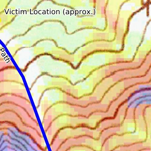
1 Park Butte Avalanche Fatality March 10 th, 2018 Report by Lee Lazzara and Dennis D Amico, Northwest Avalanche Center Recovery details provided by Whatcom County Sheriff s Office Incident snapshot Occurrence Time and Date: am (estimated) on March 10th, Call: 1015 am Recovery: Afternoon of March 10 th by Snohomish County Helicopter Rescue Team Lat/Lon: (Avalanche Crown) Location: Park Butte, Whatcom Co., Mount Baker National Recreation Area, MBS NF, WA Number in Party: snowmobilers were on-scene, unknown if all were in same party Number Caught: 1 Snowmobiler Number Partially Buried, Critical: 1 (Critical means the head was buried) Number Killed: 1 Duration of Burial: 20 min (estimated) Avalanche Type: Hard Slab (HS) Trigger: Snowmobile (AM) Size: R3 / D3 Start Zone Aspect: Northeast Start Zone Angle: Average 45 Start Zone Elevation: 5400 ft Height of Crown Face (estimated): 4 ft (1.2 m) average, 5 ft (1.5 m) maximum Width of Fracture (estimated): 200 ft (60 m) average Vertical Fall: 1000 ft (300 m) average Slab Characteristics: 4F- to 1F+ Hardness, grain type/size not measured Weak Layer Characteristics: 4F Hardness, Facets (2 mm), 3 cm thick Bed Surface Characteristics: K Hardness, Melt Freeze Crust Burial involved a terrain trap: Yes, Trees Number of people that crossed start zone before avalanche: 0 Avalanche occurred during: Descent Avalanche Rescue Gear Carried by Group: Transceivers, shovels, probes. The victim reportedly was wearing an airbag pack and deployed the airbag. Avalanche Training and Experience at Activity: Unknown level of training. Expert Rider. Cause of death: Unknown (Pending coroner s report, trauma suspected) Avalanche Classification: HS-AMu-R3-D3-O Northwest Avalanche Center
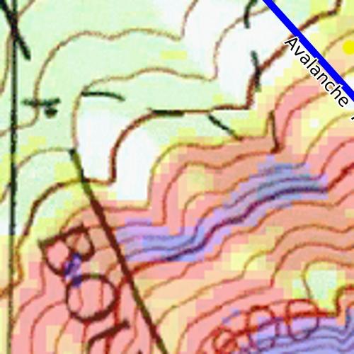
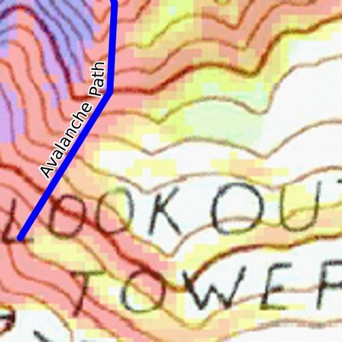
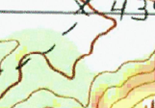
2 NWAC Forecast Zone: West Slopes North Canadian Border to Skagit River (includes Mt. Baker) Avalanche Danger Rating (All Elevation Bands): Considerable Avalanche and Terrain The accident site investigation was carried out by NWAC Professional Observer Lee Lazzara and Simon Trautman (NAC/NWAC) on March 11th. They departed from the designated snowpark on USFS Road 13 to Schriebers Meadow at 8:30 am. They traveled by snowmobile and then skis to the accident site. Due to the overhead hazard at the accident site, NWAC staff members were not able to record a complete crown profile. The avalanche on Park Butte occurred on a NE facing slope at The small bowl where it was triggered is initially very steep at the top with an average slope angle of 45 degrees. The slope angle quickly eases to around 35 degrees or less in the first few hundred feet of the path before becoming steeper again as it rolls over into a shallow gully. This gully opens up and flattens out into a narrow debris fan (4500 ) as it falls to the path terminus. Sparse small trees intrude into the path in this lower section. Trees up to 6 in diameter were snapped during the avalanche. A small amount of debris spilled over the right side of the gully into more densely treed terrain in the bottom third of the path. Signs of wind loading around Park Butte included cornices extending from the summit ridge over the path (around Park Butte fire lookout in photos) and wind scoured surfaces on the ridgeline above the avalanche and on south facing slopes on the backside of Park Butte. The path had avalanched recently; old debris was covered with storm snow adjacent to the new debris from the fatal avalanche. The avalanche had an average crown depth of 4 ft (120 cm) with some sections reaching 5 ft (150 cm) in depth. The crown was 200 wide and the flanks extended down to the stauchwall 100 vertical feet. It released on a 2-3 cm thick layer of 2 mm facets above a knife-hard melt-freeze crust. The slab itself was fairly uniform with a 4F- layer of new snow in the top 6 (15 cm), with slightly harder 4F layer below to 18 (45 cm) down from the surface. The remainder of the slab was 1F+ to the facet interface above the melt-freeze crust. It s worth noting the bed surface, the 2/8 crust, was 4 ft down in this location but was found deeper (~6 ft) in other parts of the zone at similar elevations and aspect. Snowpack and Weather The month leading up to the Park Butte avalanche began with a period of very warm, wet precipitation and high freezing levels. Precipitation beginning on February 2 nd fell primarily as rain, switching to snow in the evening of February 8 th at the Heather Meadows weather 4210 (Mt. Baker Ski Area ~12 miles to the NE of accident site). Cold temperatures along with the diminishing but cold snowfall created a strong melt-freeze crust found in below and near treeline areas throughout the Cascades. The few inches of light density snow that fell on top of the freezing crust in turn faceted during the following period of cold temperatures and clear skies. The following weeks were marked by short periods of intense snowfall between long stretches of cold weather. Northwest Avalanche Center
3 During this period, there was at least one snowmobile triggered avalanche in the Mt. Baker backcountry that appeared to be new snow and wind slab releasing on facets above the February 8 th melt-freeze crust. Regionally, 7 avalanche fatalities in 5 separate incidents occurred in the Washington Cascades over 3 consecutive weekends, all involving some combination of faceted snow over melt-freeze crusts. The Park Butte fatality was the last in this series of tragic incidents. On March 8th, a strong low pressure system with significant precipitation moved into the region. The Heather Meadows 4210 (see attached graph) registered 22 of snow with 2.4 of water equivalent from the morning of March 8 th to the morning of March 9 th. Most of this snow fell with near freezing temperatures at 4200 and with sustained moderate to strong winds from the south. The NRCS SNOTEL site in the Middle Fork of the Nooksack (Lookout ~8 miles to the NW of accident site) showed a 10 increase in snow depth from March 8 th to 9 th. The morning of March 10 th began mostly clear and cold. Temperatures at Heather Meadows warmed from the 500hrs to 1300hrs. Despite the rapid warm up, moderate south winds kept snow surfaces cool near ridgeline and on shaded aspects at most elevations. Cold snow surface conditions were noted adjacent to the avalanche path on March 11 th. Light snow transport was noted throughout the region on March 10 th due to south winds. Accident Summary The avalanche occurred on the morning of March 10th, 2018, estimated between am. A group of snowmobilers were riding in a small bowl just east of and below the Park Butte Lookout. The victim and/or other members of this group had leveled out a runway to facilitate jumping from the ridgeline onto the slope below. The avalanche was triggered when the victim, the first snowmobiler to use the runway, jumped and landed on the slope. The vertical fall from the takeoff to the point of impact was estimated at 40 vertical feet. The victim and snowmobile were both caught and carried to near the toe of the avalanche path. Rescue Summary Due to the complex nature of the terrain between where the avalanche was triggered and where the victim was buried, observed snowmobile tracks indicate many members of the group who went to the burial location traveled an indirect route around Cathedral Crag. Cathedral Crag is small rocky peak 0.5 mi NE of Park Butte. The Whatcom County Sheriff s Office interviewed two members of the party following the incident. 911 was called at 10:15 am on March 10 th. The victim s burial duration was roughly 20 minutes. He was found with a transceiver search, the top of his helmet barely visible below the snow surface. According to party members who were interviewed, the victim was wrapped around a tree and showed signs of trauma. The victim was airlifted from the accident site by the Snohomish Helicopter Rescue Team on the afternoon of March 10th. Northwest Avalanche Center


4 All Photos by Lee Lazzara, March 11 th 2018 Victim s landing spot is visible above crown. Unknown whether the tracks on left occurred before or after the slide. Overview of start zone and upper track. Park Butte is to the right of the avalanche path. Northwest Avalanche Center

5 Looking down at the landing spot and avalanche start zone from ridge (5440 ). The crown is visible below the small tree. Northwest Avalanche Center


6 Looking down lower path Looking uphill at the avalanche path. Elev 4440 ft. Northwest Avalanche Center


7 Sled burial location near the toe of the debris. Elev 4320 ft. Northwest Avalanche Center
8 Northwest Avalanche Center


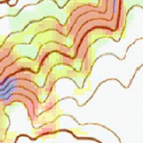
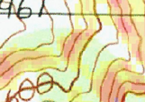
9 Slope Angle Shading: X


10 West Slopes North - Canadian Border to Skagit River Issued: 6:45 PM PST Friday, March 9, 2018 by Robert Hahn NWAC avalanche forecasts apply to backcountry avalanche terrain in the Olympics, Washington Cascades and Mt Hood area. These forecasts do not apply to developed ski areas, avalanche terrain affecting highways and higher terrain on the volcanic peaks above the Cascade crest level. The Bottom Line: Several overlapping avalanche problems will create dangerous avalanche conditions Saturday. Avoid steep slopes over 35 degrees where avalanches start. Expect changing conditions through the day as warming and a strong sun effect the snow surface making it easier to trigger all avalanches. Elevation Saturday Outlook for Sunday Above Treeline Considerable Near Treeline Considerable Below Treeline Considerable Dangerous avalanche conditions. Careful snowpack evaluation, cautious route-finding and conservative decision-making essential. Considerable Dangerous avalanche conditions. Careful snowpack evaluation, cautious route-finding and conservative decision-making essential. Considerable Dangerous avalanche conditions. Careful snowpack evaluation, cautious route-finding and conservative decision-making essential. Considerable Avalanche Problems for Saturday Wind Slab Wind slabs can take up to a week to stabilize. They are confined to lee and cross-loaded terrain features and can be avoided by sticking to sheltered or wind scoured areas. Avalanche Problem Aspect/Elevation Likelihood Size Loose Wet Loose wet avalanches occur where water is running through the snowpack, and release at or below the trigger point. Avoid terrain traps such as cliffs, gullies, or tree wells. Exit avalanche terrain when you see pinwheels, roller balls, a slushy surface, or during rain-on-snow events. Avalanche Problem Aspect/Elevation Likelihood Size Persistent Slab Persistent slabs can be triggered by light loads and weeks after the last storm. You can trigger them remotely and they often propagate across and beyond terrain features that would otherwise confine wind and storm slabs. Give yourself a wide safety buffer to handle the uncertainty. Avalanche Problem Aspect/Elevation Likelihood Size


11 Persistent Deep Slab Deep, persistent slabs are destructive and deadly events that can take months to stabilize. You can triggered them from well down in the avalanche path, and after dozens of tracks have crossed the slope. Give yourself a wide safety buffer to handle the uncertainty, potentially for the remainder of the season. Avalanche Problem Aspect/Elevation Likelihood Size
12 Avalanche Forecast for Saturday A new persistent slab avalanche problem has been observed in the Stevens Pass area and in locations along the Eastern Cascades. Newly buried surface hoar and facets have resulted in several avalanches on a variety of aspects (E, SE, S, NW) between feet. Current observations have not found this layer in other Western Regions. However, use caution. If you experience sudden collapses, shooting cracks, or whumping noises, avoid all nearby avalanche terrain. You will be able to trigger wind slabs on lee slopes and cross-loaded features. Use visual clues such as snow drifts, uneven snow surfaces, and fresh cornices to identify and avoid nearby slopes where the wind has deposited snow. Expect new rollerballs, pinwheels, and small loose wet avalanches to occur on sunny aspects throughout the day. These conditions will occur first on steep rocky slopes receiving direct sunshine. Stay off of steep slopes where you see signs of wet surface snow conditions. Persistent and deep persistent slab avalanche may still occur. To avoid these low likelihood - high consequence situations, stay out of large open slopes that may harbor this difficult to predict and manage avalanche problem. While it is difficult to trigger these types of avalanches, smaller surface avalanches such as loose wet and wind slabs may step down, failing into deeper older layers. Avalanche Summary Several new avalanches were reported Friday. Small natural wind slab avalanches were observed near Alpental Ski area on steep NE facing terrain at A cornice triggered wind slab was observed in the Crystal Backcountry on a E slope at Several very large new crowns estimated to be 4-5' tall were observed in the Sourdough Mountains NE of Mt Rainier. These avalanches were seen on NE facing slopes around Most of these avalanches occurred Thursday night into Friday morning. New snow fell across the western regions of the Cascades Thursday night and Friday. Significant changes in snow totals were experienced with elevation. Wet heavy snow and rain was observed in up to 5500 Crystal, 4400 Snoqualmie, and 4300 farther north. Above these elevations, inches of new storm snow accumulated. Generally SW winds transported the snow in all regions forming new wind slabs on lee slopes and cross-loaded mid-slope features. This new snow has fallen on a variety of old snow surfaces including settled cold snow and new melt-freeze crusts. There is potential in some locations that surface hoar and/or near surface facets were buried. Several older persistent weak layers exist within the snowpack. On E-S-W aspects a thin facet-crust combo (2/23) can be found. Snowpack test results show this layer healing but it has been reactive in some snowpack tests. An older deeper and more widespread persistent weak layer has been observed for several weeks. Weak sugary facets (2/13) sit just above a firm crust formed and buried in early February (2/8). This crust is generally found about 3-4 feet below the snow surface. There are no other significant layers of concern below the 2/8 crust. Observations Baker An avalanche professional at Heather Meadows reported significant wind transportation of snow. He did not find a buried persistent weak layer below the recent storm snow in the locations he observed. Snoqualmie An avalanche professional at Alpental reported rain up to 4400 feet Thursday night. Two new natural wind slabs were observed in steep NE facing terrain. South NWAC professional observer Jeremy Allyn traveled in the Crystal Backcountry Friday. He found significant wind transportation of the new snow above A cornice failure triggered a widely propagating wind slab 2 feet deep on an E aspect of East Peak. Observations generally demonstrated the new snow was bonding well to the old snow surface. Crystal Mountain ski patrol reported several new large crowns seen across the White River valley in the Sourdough Mountains. Avalanches occurred on NE aspects and were estimated to be 4-5 feet deep. Wind transported snow was observed on the upper mountain. Mountain Weather Synopsis for Saturday & Sunday A fine weekend is in store for the Pacific Northwest with a fair helping of sunshine and rising freezing levels. Upper level ridging over eastern Washington/Oregon will slowly slide east today. A pair of weak upper level shortwaves embedded in SW flow aloft will traverse across Mt. Hood and the south Cascades late this afternoon and tonight. This may bring a stray shower, but most likely just result in an increase in high clouds over the area. Upper level ridging will further amplify as it retrogrades over the western US on Sunday. This will allow freezing levels to climb further. Offshore flow may create some local temperature inversions in the Cascades Passes today and tomorrow but overall easterly flow is not expected to have a large impact on temperatures/freezing levels. Dry and mild weather will continue Sunday night, but offshore flow will increase as a weak N-S oriented frontal boundary approaches 130W.
13 24 Hour Quantitative Precipitation ending at 4 am Location Sun Mon Hurricane Ridge 0 0 Mt Baker Ski Area 0 0 Washington Pass 0 0 Stevens Pass 0 0 Snoqualmie Pass 0 0 Mission Ridge 0 0 Crystal Mt 0 0 Paradise 0 0 White Pass 0 0 Mt Hood Meadows lt.10 0 Timberline lt.10 0 LT = less than; WE or Water equivalent is the liquid water equivalent of melted snow in hundredths of inches. As a rough approximation 1 inch of snow = about.10 inches WE, or 10 inches of snow = about 1 inch WE. Snow Level/Freezing Level in feet Day Olympics Northwest Northeast Cascades Cascades Central Cascades South Cascades Easterly Flow in Passes Saturday Afternoon 6000' 5500' 5000' 5500' 6500' * Saturday Night 6000' 5500' 1000' 3000' 4500' * Sunday Morning 6000' 5500' 1000' 3000' 4500' * Sunday Afternoon 7000' 6500' 6500' 7000' 8000' * Sunday Night 8000' 7000' 4000' 6500' 8000' * Cascade Snow / Freezing Levels noted above refer to the north (approximately Mt Baker and Washington Pass), central (approximately Stevens to White Pass) and south (near Mt Hood). Freezing Level is when no precipitation is forecast. * Note that surface snow levels are common near the passes during easterly pass flow and may result in multiple snow / freezing levels. USE AT YOUR OWN RISK This Backcountry Avalanche Forecast is provided in conjunction with the US Forest Service, and is intended for personal and recreational purposes only. Safe backcountry travel requires preparation and planning, and this information may be used for planning purposes but does not provide all the information necessary for backcountry travel. Advanced avalanche education is strongly encouraged. The user acknowledges that it is impossible to accurately predict natural events such as avalanches in every instance, and the accuracy or reliability of the data provided here is not guaranteed in any way. This forecast describes general avalanche conditions and local variations will always occur. This forecast expires 24 hours after the posted time unless noted otherwise.
 visited the incident site the day after the fatality.")
14 American Avalanche Association Forest Service National Avalanche Center Avalanche Incident Report: Short Form Occurrence Date (YYYYMMDD): and Time (HHMM): 945 Comments: Lee Lazzara (NWAC) and Simon Trautman (NAC/NWAC) visited the incident site the day after the fatality. Details related to the recovery and the accident summary were provided to NWAC from the Whatcom County Sheriff's Office. The Sheriff's Office interviewed two party members. The time of the avalanche is estimated to have occurred between am. Reporting Party Name and Address: Northwest Avalanche Center 7600 Sandpoint Way NE Seattle, WA Avalanche Characteristics: Type: HS Aspect: NE Trigger: AM Slope Angle: 45 deg avg Size: R 3 \ D 3 Elevation: 5400 m / ft Sliding surface (check one): In new New/old In old Ground Group Number of People Depth to Face m / ft Location: State: WA County: Whatcom Forest: Mt Baker National Recreation Area, Mt Baker-Snoqualmie NF Peak, Mtn Pass, or Drainage: Park Butte Site Name: Lat/Lon or UTM: (Avalanche Crown) Time Duration Dimensions Caught 1 recovered of burial m / ft Partially Average Maximum Buried Height of Crown Face 1.2 m 1.5 m Not critical Width of Fracture 60 m Partially 1 N/Av 20 min N/Av Vertical Fall 300 m Buried-- (estimated) Snow Hardness Grain Type Grain Size (mm) Critical Slab 4F- to 1F+ N/Av N/Av Completely Weak 4F FC 2 Buried Layer Number of people injured: Number of people killed: 1 Bed K MFcr Surface Thickness of weak layer: 3 mm / cm / in Burial involved a terrain trap? no yes type: Trees Number of people that crossed start zone before the avalanche: 0 Location of group in relation to start zone during avalanche: high middle low below all unknown Avalanche occurred during ascent descent Subject Name Age Gender Address Phone Activity 1 27 M Snowmobile Snowmobilers Unclear if all were in same gropu Snowmobile Equipment Carried Transceiver Shovel Probe Experience at Activity Unknown Novice Intermediate Advanced Expert Avalanche Training Unknown None Some Advanced Expert Signs of Instability Noted by Group Unknown Injuries Sustained None Extent of Injuries or Cause of Death Asphyxiation 1
15 None Recent avalanches Shooting cracks Collapse or whumphing Low test scores First Aid Doctor s care Hospital Stay Fatal Damage Number of Vehicles Caught:1 Number Structures Destroyed: Estimated Loss: $ Head Trauma Spinal Injury Chest Trauma Skeletal Fractures Other: Trauma suspected but not confirmed Accident Summary Include: events leading to accident, group s familiarity with location, objectives, route, hazard evaluation, etc. The avalanche occurred on the morning of March 10th, 2018, estimated between am. A group of snowmobilers were riding in a small bowl just east of and below the Park Butte Lookout. The victim and/or other members of this group had leveled out a runway to facilitate jumping from the ridgeline onto the slope below. The avalanche was triggered when the victim, the first snowmobiler to use the runway, jumped and landed on the slope. The vertical fall from the takeoff to the point of impact was estimated at 40 vertical feet. The victim and snowmobile were both caught and carried to near the toe of the avalanche path. Rescue Summary Include: description of initial search, report of accident, organized rescue, etc. Due to the complex nature of the terrain between where the avalanche was triggered and where the victim was buried, observed snowmobile tracks indicate many members of the group who went to the burial location traveled an indirect route around Cathedral Crag. Cathedral Crag is small rocky peak 0.5 mi NE of Park Butte. The Whatcom County Sheriff s Office interviewed two members of the party following the incident. 911 was called at 10:15 am on March 10th. The victim s burial duration was roughly 20 minutes. He was found with a transceiver search, the top of his helmet barely visible below the snow surface. According to party members who were interviewed, the victim was wrapped around a tree and showed signs of trauma. The victim was airlifted from the accident site by the Snohomish Helicopter Rescue Team on the afternoon of March 10th. Rescue Method Attach additional pages as needed. Include weather history, snow profiles, reports from other agencies, diagram of site, photographs, and any other supporting information Self rescue Transceiver Spot probe Probe line Rescue dog Voice Object Digging Other: Please see full report at Please send to: CAIC; 325 Broadway WS1; Boulder CO 80305; caic@state.co.us and to the nearest Avalanche Center. 2
American Avalanche Association Forest Service National Avalanche Center Avalanche Incident Report: Long Form
 American Avalanche Association Forest Service National Avalanche Center Avalanche Incident Report: Long Form Please send to: CAIC; 325 Broadway WS1; Boulder CO 80305; caic@qwest.net; Fax (303) 499-9618
American Avalanche Association Forest Service National Avalanche Center Avalanche Incident Report: Short Form
 American Avalanche Association Forest Service National Avalanche Center Avalanche Incident Report: Short Form Occurrence Date (YYYYMMDD): 20170205 and Time (HHMM): 1100 Comments: Most avalanche characterists
Corona Bowl Avalanche Incident, December 6th, 2015
 Corona Bowl Avalanche Incident, December 6th, 2015 Report prepared by NWAC and Stevens Pass Pro Patrol Incident snapshot Time and Date: 11:48 AM, December 6 th, 2015 Location: Corona Bowl, Chief Mountain,
Avalanche danger high in parts of NCW
 3/23/2017 Avalanche danger high in parts of NCW THURSDAY, MARCH 23, 2017 Avalanche danger high in parts of NCW by Christine Pratt Public Safety Feb. 9, 2017, 4:52 p.m. Photo provided An avalanche hit the
Avalanche Mountain Incident March 4 th, 2017
 Avalanche Mountain Incident March 4 th, 2017 Report by Dennis D Amico, Robert Hahn and Jeremy Allyn Incident snapshot Occurrence Time and Date: Approximately 3 pm on March 4th, 2017 Time First Reported
Morning Star Peak Avalanche Accident
 Morning Star Peak Avalanche Accident Saturday, December 4, 2010 Date: 2010-12-13 Submitted by: Oyvind Henningsen Everett Mountain Rescue and Mark Moore NWAC Place: Morning Star Peak, north-central WA Cascades
Cottonwood Lake Avalanche Fatality February, 25th 2018
 Cottonwood Lake Avalanche Fatality February, 25th 2018 Report by Josh Hirshberg and Dennis D Amico, Northwest Avalanche Center Incident snapshot Occurrence Time and Date: Approximately 12:00pm Feb 25,
Excelsior Pass Avalanche Accident January 1, 2008
 Excelsior Pass Avalanche Accident January 1, 2008 Accident Summary Time: 1 January 2008, approximately 13:00 hrs Location: Near Excelsior Pass to east of Church Mt, Northern Washington Cascades WA Activity:
Snow Lake Divide Avalanche Fatality February 25th, 2018
 Snow Lake Divide Avalanche Fatality February 25th, 2018 Report by Jeremy Allyn and Dennis D Amico, Northwest Avalanche Center Incident snapshot: Occurrence Time and Date: February 25, 2018 (estimated time:
Granite Mountain Avalanche Fatality, December 31st, 2015 Report prepared by NWAC
 Granite Mountain Avalanche Fatality, December 31st, 2015 Report prepared by NWAC Incident snapshot (All avalanche fields estimated from interview with Seattle Mountain Rescue) Time and Date: Mid-day or
Typical avalanche problems
 Typical avalanche problems The European Avalanche Warning Services (EAWS) describes five typical avalanche problems or situations as they occur in avalanche terrain. The Utah Avalanche Center (UAC) has
Henderson Mountain Avalanche Accident Two riders caught, one partially buried, one fully buried
 Henderson Mountain Avalanche Accident Two riders caught, one partially buried, one fully buried Custer-Gallatin National Forest 28 November 2014 Synopsis A group of 6 or 7 snowmobilers (part of a larger
Twin Lakes Avalanche Incident 1/31/2016
 Twin Lakes Avalanche Incident 1/31/2016 Location: Place State Published by: Dave Bingaman (PAC), George Halcom (PAC), and Kent May (PAC) Twin Lakes, Salmon River Mountains Idaho Date 01/31/2016 Time Summary
Slot Couloir Accident, Snoqualmie Mt
 Body Page 1 Slot Couloir Accident, Snoqualmie Mt 4-27-14 Date and Time: estimated 12 pm, Sunday 4/27/14 Location: Slot Couloir, Snoqualmie Mt Number in Party: 2 backcountry skiers Number hurt: 1 backcountry
SYNOPSIS WEATHER AND SNOWPACK
 Peak 6996 Avalanche Fatality Incident Report Glacier National Park, MT Date of Avalanche: 31 March 2010 Date of Investigation: 2 April 2010 Investigation Team: Erich Peitzsch (USGS), Ted Steiner (Chugach
Swede Creek Avalanche Incident Report Swede Creek, Whitefish Range, MT Date of Avalanche: 23 January 2016 Date of Site Visit: 24 January 2016
 Swede Creek Avalanche Incident Report Swede Creek, Whitefish Range, MT Date of Avalanche: 23 January 2016 Date of Site Visit: 24 January 2016 INCIDENT SYNOPSIS On Saturday, January 23, 2016, three snowmobilers
Lane Peak, Fly Couloir Avalanche 2/25/2017
 Lane Peak, Fly Couloir Avalanche 2/25/2017 NWAC Report by Jeremy Allyn and Dennis D Amico Incident snapshot: Occurrence Time and Date: 1234 pm, February 25, 2017 Lat/Lon: 46.7581, -121.7531 (estimated,
Avalanche Awareness and Leading a Companion Rescue
 Avalanche Awareness and Leading a Companion Rescue Introduction: Traveling in the backcountry is a great way to enjoy the outdoors and friends. It s important that when we travel in the backcountry we
Number Caught: 2 Partially Buried, Non-Critical: 1 Partially Buried, Critical: 0 Fully Buried: 1 Injured: 1 Killed: 1
 South Waldron Creek Avalanche Fatality 2 snowmobilers caught, 1 carried and injured, 1 fully buried and killed. Teton River, MT Helena-Lewis and Clark National Forest January 5 th, 2019 Avalanche Details
Proceedings, International Snow Science Workshop, Breckenridge, Colorado, 2016
 AVALANCHE FORECASTING AND MESSAGING FOR UNUSUAL AVALANCHE CONDITIONS IN A MARITIME SNOW CLIMATE-BURIED SURFACE HOAR INTERNATIONAL SNOW SCIENCE WORKSHOP 2016 IN BRECKENRIDGE, CO Steve A. Reynaud Sierra
2/16/2014 Idaho Frenchman Creek Published by Scott Savage, SAC
 Location: Place Frenchman Creek drainage, Smoky Mountains State Idaho Date 2/16/2014 Time 2:00pm Summary 4 snowmobilers buried, 1 killed, 1 injured Number: Caught 4 Fully Buried 4 Injured 1 Killed 1 Avalanche
NWAC Blog. Cornices - don't walk the line! Written by Robert Hahn on March 14, Last update on May 15, 2017.
 NWAC Blog Cornices - don't walk the line! Written by Robert Hahn on March 14, 2017. Last update on May 15, 2017. Human-triggered cornice fall avalanche from March 10th, 2017. The crown release exposed
Avalanche Accident Report
 Hatcher Pass Avalanche Center POB 1223 Chickaloon, AK 99674 907-746-4566 info@hatcherpassavalanchecenter.org Avalanche Accident Report January 2, 2016 Avalanche Accident in Grubstake Gulch, Talkeetna Mountains,
Part 1: Introduction to Decision Making
 Part 1: Introduction to Decision Making 1.1 - Anatomy of a Decision ABOUT AIARE Learning Outcomes Identify that backcountry decision making involves five key components: Plan, Observe, Teamwork, Choose
Avalanche Safety Guidelines
 Introduction Avalanche Safety Guidelines Worldwide, avalanches kill more than 150 people annually and thousands more are partly buried or injured. Although highway motorists and others can be involved
Crystal Mountain Snow Safety Union Creek Avalanche Accident Report December 2, 2007
 Crystal Mountain Snow Safety Union Creek Avalanche Accident Report December 2, 2007 Prepared by Paul Baugher, Chris Morin, Crystal Mt Ski Patrol/ Snow Safety and Mark Moore, NWAC Accident Summary Time:
Avalanche Safety Guidelines This guideline is intended as a general introduction to this topic.
 Introduction Worldwide, avalanches kill more than 150 people annually and thousands more are partly buried or injured. Although highway motorists and others can be involved in an avalanche, climbers, backcountry
Twin Wildcat Lakes Avalanche Wednesday, February 1, 2012 Incident Report
 Twin Wildcat Lakes Avalanche Wednesday, February 1, 2012 Incident Report February 17, 2012 Location: (See Appendix A-1 Maps) Hungry Horse Ranger District Flathead National Forest -Region One Flathead County
Twin Peaks Near Miss Report Turnagain Pass, Kenai Mountains, Alaska
 Twin Peaks Near Miss Report Turnagain Pass, Kenai Mountains, Alaska Location: East Face, Twin Peaks Lat/Lon: 60.71343N, -149.38205E Date: February 3, 2018, Time: 3:50 pm Report by: Chugach National Forest
Proceedings, International Snow Science Workshop, Breckenridge, Colorado, 2016 ANALYSIS OF UTAH AVALANCHE FATALITIES IN THE MODERN ERA
 ANALYSIS OF UTAH AVALANCHE FATALITIES IN THE MODERN ERA Drew Hardesty 1 * 1 Utah Avalanche Center ABSTRACT: The Utah Avalanche Center (UAC) has records of Utah avalanche fatalities for the modern era,
International Snow Science Workshop
 A PRACTICAL USE OF HISTORIC DATA TO MITIGATE WORKER EXPOSURE TO AVALANCHE HAZARD Jake Elkins Jackson Hole Mountain Resort, Teton Village, Wyoming Bob Comey* Jackson Hole Mountain Resort, Teton Village,
Elevation Bands Description of terrain characteristics to which the avalanche danger ratings apply.
 1 Definition of Terms used in Daily Trip Forms This document is part of Decision Making in Avalanche Terrain: a fieldbook for winter backcountry users by Pascal Haegeli, Roger Atkins and Karl Klassen and
Avalanche accident case study: Persistent buried weak layer in the Central Idaho Mountains
 Avalanche accident case study: Persistent buried weak layer in the Central Idaho Mountains Doug Abromeit* Forest Service National Avalanche Center Bozo Cardozo Sun Valley Helicopter Ski Guides Ketchum,
ENVIRONMENTAL HAZARDS OF AVALANCHES: PRELIMINARY RESEARCH IN GLACIER NATIONAL PARK
 ENVIRONMENTAL HAZARDS OF AVALANCHES: PRELIMINARY RESEARCH IN GLACIER NATIONAL PARK Site Focus: Balu Pass, Glacier National Park, B.C. Avalanche path near Balu Pass. (Photo Courtesy of: www.leelau.net/2007/rogerspass/day1/1)
AVALANCHE TERRAIN. Bill Glude Alaska Avalanche Specialists All photos and graphics Bill Glude unless otherwise noted.
 Bill Glude Alaska Avalanche Specialists 20111202 All photos and graphics Bill Glude unless otherwise noted. AVALANCHE TERRAIN The Key Questions 1.) Could the terrain produce an avalanche?! a.) Where you
The Kendall Trap. Charlie Hagedorn
 This photo-essay is neither a route-description nor a guide; it is intended to raise, among skiers already familiar with the area, awareness of hazards, to suggest not doing something. Take accredited
Skyland Avalanche Saturday, February 25, 2012 Incident Report
 Skyland Avalanche Saturday, February 25, 2012 Incident Report April 12, 2012 Location: (See Appendix A-1 Maps) Hungry Horse Ranger District Flathead National Forest - Region One Flathead County, Montana
Washington Explorer Search and Rescue Pierce County Unit February 2013
 Washington Explorer Search and Rescue Pierce County Unit February 2013 Part I Winter Training Logistics Gear for Winter Training Building Snow Caves & Other Snow Shelters Winter Training Logistics - 2013
In southern Upper Valais a very high avalanche danger will be encountered in some regions Edition: , 08:00 / Next update: 9.1.
 Page 1/6 In southern Upper Valais a very high avalanche danger will be encountered in some regions Edition: 9.1.2018, 08:00 / Next update: 9.1.2018, 17:00 Avalanche danger updated on 9.1.2018, 08:00 region
Avalanche Observations
 Avalanche Observations Avalanche Observations 3.1 Introduction Observations of past and present avalanche activity are of the utmost importance for any avalanche forecasting operation. These data should
2010 International Snow Science Workshop
 200 International Snow Science Workshop TEN YEARS OF AVALANCHE DEATHS IN THE UNITED STATES, 999/00 TO 2008/09 Dale Atkins* RECCO AB ABSTRACT: After reaching a twenty-year low in the late 980s avalanche
International Snow Science Workshop
 Chinook Pass: 25 Years On John Stimberis*, Washington State Department of Transportation, Snoqualmie Pass, Washington, USA ABSTRACT: Washington State Route 410 over Chinook Pass (1656 m) is generally closed
Self-Guided Group Organization - Recommendations
 Self-Guided Group Organization - Recommendations Introduction The purpose of this document is to offer a template to self-guided groups with respect to pre-trip and on-trip planning. The ultimate goal
New Motorized Level I Avalanche Class!
 New Motorized Level I Avalanche Class! New guidelines by American Avalanche Association. Fast paced 24 hour class with minimum of 60% of hours on snow. This is a snowmobile/snow bike specific class and
Avalanche Safety Basics By Sandy K. Ott
 Avalanche Safety Basics By Sandy K. Ott For Mountain Riders, or Those Going Into the Mountains to Ride There is one common theme when the avalanche experts go investigate avy incidents. The responses they
NivoTest : a personal assistant for avalanche risk assessment
 NivoTest : a personal assistant for avalanche risk assessment R.Bolognesi METEISK, CP 993, CH-1951 SION. www.meteorisk.com Introduction About avalanche risk Every mountaineer knows that avalanche hazard
Ski / Sled tracks as an expression of avalanche risk Jordy Hendrikx 1 & Jerry Johnson 2,1 1.
 Ski / Sled tracks as an expression of avalanche risk Jordy Hendrikx 1 & Jerry Johnson 2,1 1 Snow and Avalanche Laboratory, Montana State University, Bozeman, Montana, USA 2 Political Science, Montana State
Going-to-the-Sun Road, Glacier National Park, MT, USA Avalanche Path Atlas
 Going-to-the-Sun Road, Glacier National Park, MT, USA Avalanche Path Atlas Erich H. Peitzsch Daniel B. Fagre USGS Northern Rocky Mountain Science Center West Glacier, MT, USA Introduction... 2 Overview
Chasing Skylines in Kyrgyzstan BMC Reference: 15/ 02
 Chasing Skylines in Kyrgyzstan 2015 BMC Reference: 15/ 02 21/02/2015 to 15/03/2015 Contact: Sophie Nunn Email: Sophienunn@gmail.com, Phone: 07540454054 Address: 7 Richmond Lodge, 6 Victoria Avenue, Swanage,
AVALANCHE FLOTATION DEVICES
 AVALANCHE FLOTATION DEVICES 1. ISSUE In the Coroner s Report into the deaths of Ms. Kimberly Anne Manchip and Mr. Daisuke Matsui, both of whom were caught in an avalanche and died from asphyxiation, the
Example of the layout of a Fieldwork Atlas
 Example of the layout of a Fieldwork Atlas Example of a Worksite with multiple facilities and work goals in one area: Map Center 49 3 46 N 117 3 11 W Noname Area with typical travel route marked. Avalanche
THE SME AVALANCHE TRAGEDY OF JANUARY 20, 2003: A SUMMARY OF THE DATA. Dick Penniman* Snowbridge Associates Frank Baumann Baumann Engineering
 THE SME AVALANCHE TRAGEDY OF JANUARY 20, 2003: A SUMMARY OF THE DATA Dick Penniman* Snowbridge Associates Frank Baumann Baumann Engineering ABSTRACT: On January 20, 2003 guided skiers and snowboarders
Avalanches and the Mount Whitney Basin
 Avalanches and the Mount Whitney Basin 10 April 2006 by Bob Rockwell Prelude Avalanches are a fact of life in high mountains in winter, and we take courses to find out about them. We learn how to assess
THRESHOLD GUIDELINES FOR AVALANCHE SAFETY MEASURES
 BRITISH COLUMBIA MINISTRY OF TRANSPORTATION & INFRASTRUCTURE AVALANCHE & WEATHER PROGRAMS THRESHOLD GUIDELINES FOR AVALANCHE SAFETY MEASURES British Columbia Ministry of Transportation & Infrastructure
Oregon Region Report from the Oregon Mountain Rescue Council
 Oregon Region Report from the Oregon Mountain Rescue Council More current information can be found on each team s web site or at the Oregon Mountain Rescue Council s web site at http://corvallismountainrescue.org/omrc/
Avalanche Incident on Twin Peaks Flint Creek Range December 24, 2013
 Avalanche Incident on Twin Peaks Flint Creek Range December 24, 2013 On December 24, 2013, a group of snowmobilers were riding in familiar terrain in the Flint Creek Range 8 miles southeast of Phillipsburg,
TUPPER DESIGNATED ACCESS ROUTE
 TUPPER DESIGNATED ACCESS ROUTE 1 FOR ACCESS/EGRESS TO CONNAUGHT, LOOKOUT, STONE ARCH, PORTAL PATHS AND TUPPER TRAVERSE EGRESS Length: 2.6km Vertical Gain: +162m / -83m (Values are for access. For egress,
MP : the top of the bottom switchback
 MP 237 238: the top of the bottom switchback For reference this section of U S Highway 40 has been called the top of the bottom switchback on the Grand County side of the Pass. It is here that the proposed
Mountain Rescue Council England & Wales. Incident Report 2003
 Mountain Rescue Council Charity No. Mountain Rescue Council & Incident Report Copyright Mountain Rescue Council (First Revision -Jun-) All enquiries please direct to: - Ged Feeney MRC Statistics Officer
Proceedings, International Snow Science Workshop, Banff, 2014
 TRAVEL ADVICE FOR THE AVALANCHE PROBLEMS: A PUBLIC FORECASTING TOOL Wendy Wagner 1 * and Drew Hardesty 2 1 Chugach National Forest Avalanche Center, Girdwood, Alaska 2 Utah Avalanche Center, Salt Lake
LEVEL 1 - AVALANCHE OVERVIEW HANDOUT
 Bill Glude Alaska Avalanche Specialists 20111202 All photos and graphics Bill Glude unless otherwise noted. LEVEL 1 - AVALANCHE OVERVIEW HANDOUT Summary of Key Points Statistics 1 2 3 Urban Avalanches
GOLDEN EARS PROVINCIAL PARK
 GOLDEN EARS PROVINCIAL PARK Trail Information as of October 10 th 2015 Do not underestimate the mountainous wilderness of Golden Ears Provincial Park. The combination of rugged terrain and rapidly changing
Scenario #1 - GROUND SEARCH
 Scenario #1 - GROUND SEARCH An elderly male dementia patient has walked away from a residence in a rural area. He has done this before. It is now 1900hrs. He has been missing for four hours and needs medication.
Scottish Mountain Rescue Avalanche Burial Organised Rescue Response SCOTTISH MOUNTAIN RESCUE AVALANCHE BURIAL - ORGANISED RESCUE RESPONSE
 Scottish Mountain Rescue Avalanche Burial Organised Rescue Response SCOTTISH MOUNTAIN RESCUE AVALANCHE BURIAL - ORGANISED RESCUE RESPONSE The International Commission for Alpine Rescue (ICAR) recommends
AN AVALANCHE CHARACTERIZATION CHECKLIST FOR BACKCOUNTRY TRAVEL DECISIONS. Roger Atkins* Canadian Mountain Holidays
 AN AVALANCHE CHARACTERIZATION CHECKLIST FOR BACKCOUNTRY TRAVEL DECISIONS Roger Atkins* Canadian Mountain Holidays ABSTRACT: This paper presents a checklist to assess the character of likely avalanche activity
Introduction to Safety on Glaciers in Svalbard
 Introduction to Safety on Glaciers in Svalbard Content Basic info on Svalbard glaciers Risk aspects when travelling on glaciers Safe travel on glaciers UNIS safety & rescue equipment Companion rescue in
2010 International Snow Science Workshop
 MAPPING EXPOSURE TO AVALANCHE TERRAIN Cam Campbell* and Peter Marshall Canadian Avalanche Centre, Revelstoke, British Columbia ABSTRACT: During the winter of 2009-10, several signs were created in collaboration
AVALANCHE SKILLS TRAINING 1 MOUNT CAIN
 Thank you for choosing Island Alpine Guides for your Avalanche Skills Training. This package contains some background information to help you prepare, including meeting times and places, and a complete
Proceedings, 2012 International Snow Science Workshop, Anchorage, Alaska
 HISTORICAL ANALYSIS OF AVALANCHE FATALITIES IN DENALI NATIONAL PARK Kevin Wright 1,2 and Tucker Chenoweth 1,3 1 Denali National Park Mountaineering Program, Talkeetna, AK, USA 2 Chugach National Forest
2.08 AVALANCHE SEARCH AND RESCUE. Q: What is the process to provide feedback on the Interim Policy and Avalanche Safety Plan?
 2.08.1 RELATED DOCUMENTS 2.08 Avalanche Search and Rescue Policy 2.08 AVALANCHE SEARCH AND RESCUE 2.08.2 FREQUENTLY ASKED QUESTIONS AVALANCHE SAFETY PLANNING Q: Are SAR Groups required to develop their
Trail Phasing Plan. Note: Trails in the Clear Creek Canyon area (Segments will be finalized in the future to minimize wildlife impacts
 Note: Trails in the Clear Creek Canyon area (Segments 2 5 and a future JCOS connection) will be finalized in the future to minimize wildlife impacts Trail Phasing Plan P Parking 3 Easy Trail Intermediate
AVALANCHE INSTRUCTOR S MANUAL TAB: TEST BANK CHAPTER 9. UPDATED VERSION AVALANCHE TEST BANK (without answers) January 1999
 January 1999") AVALANCHE INSTRUCTOR S MANUAL TAB: TEST BANK CHAPTER 9 UPDATED VERSION AVALANCHE TEST BANK (without answers) January 1999 This document replaces the October 1995 version in Chapter 9 of your Avalanche
AVALANCHE INSTRUCTOR S MANUAL TAB: TEST BANK CHAPTER 9 UPDATED VERSION AVALANCHE TEST BANK (without answers) January 1999 This document replaces the October 1995 version in Chapter 9 of your Avalanche
Route #2) Mt. Massive - Southwest Slopes
 Mt. Massive - Southwest Slopes") Route #2) Mt. Massive - Southwest Slopes Difficulty: Class 2 Ski: Advanced, D6 / R2 / III Exposure: Summit Elevation: Trailhead Elevation: Elevation Gain: Round-trip Length: Trailhead: County Sheriff:
Route #2) Mt. Massive - Southwest Slopes Difficulty: Class 2 Ski: Advanced, D6 / R2 / III Exposure: Summit Elevation: Trailhead Elevation: Elevation Gain: Round-trip Length: Trailhead: County Sheriff:
23 rd National Avalanche School Snowbird Ski and Summer Resort, UT October 27-31,2013. Student Prework
 23 rd National Avalanche School Snowbird Ski and Summer Resort, UT October 27-31,2013 Student Prework MOUNTAIN SNOWPACK PRE-WORK (Ethan Greene) NOTE: For an introduction to the material to be covered read
Risk Management Plan
 Risk Management Plan Revised June 14, 2011 by Bela G. Vadasz Technical Director Alpine Skills International 11400 Donner Pass Rd. Truckee, CA 96161 (530) 582-9170 w w w. a l p i n e s k i l l s. c o m
AVALANCHE SAFETY PLAN
 AVALANCHE SAFETY PLAN MUNICIPALITY OF VALTOURNENCHE Valtournenche is a town located at the foot of the Mount Cervin, whose beauty attracts a large number of tourists. The morphology of the territory, characterized
Proceedings, International Snow Science Workshop, Breckenridge, Colorado, 2016
 THE WHITE PASS AND YUKON ROUTE AVALANCHE PROGRAM, FORECASTING AND RISK MAN- AGEMENT FOR A HISTORICAL RAILROAD Bill Glude Alaska Avalanche Specialists, Juneau, AK The White Pass and Yukon Route (WPYR) is
Draft II - Trip Report by Kurt Wibbenmeyer
 Draft II - Trip Report by Kurt Wibbenmeyer COLORADO MOUNTAIN CLUB FAIRWEATHER MOUNTAIN EXPEDITION 2010 TEAM Rich McAdams Leader Mike Butyn Wayne Herrick Gerry Roach Bill Blazek Dave Covill Jim Rickard
FRANCE : HOW TO IMPROVE THE AVALANCHE KNOWLEDGE OF MOUNTAIN GUIDES? THE ANSWER OF THE FRENCH MOUNTAIN GUIDES ASSOCIATION. Alain Duclos 1 TRANSMONTAGNE
 FRANCE : HOW TO IMPROVE THE AVALANCHE KNOWLEDGE OF MOUNTAIN GUIDES? THE ANSWER OF THE FRENCH MOUNTAIN GUIDES ASSOCIATION ABSTRACT : Alain Duclos 1 TRANSMONTAGNE Claude Rey 2 SNGM The French Mountain Guides
Route #1) Mt. of the Holy Cross - North Ridge
 Mt. of the Holy Cross - North Ridge") Climbing 14ers can be very dangerous, please read the Mountaineering Safety Page and make sure you have a map+compass and can use them effectively, without the help of electronic devices. Route #1) Mt.
Climbing 14ers can be very dangerous, please read the Mountaineering Safety Page and make sure you have a map+compass and can use them effectively, without the help of electronic devices. Route #1) Mt.
Seven mountain peaks you must admire in Washington state
 Seven mountain peaks you must admire in Washington state heraldnet.com /life/seven-mountain-peaks-you-must-admire-in-washington-state/ From a distance, the mountains of the Cascade and the Olympic ranges
SHELTER DESIGN: IGLOO SNOW SHELTER
 CONSTRUCTION: CHALLENGING 2 to 3 hours for two people. EQUIPMENT: Sawing instrument SEASON: Winter The Igloo shelter is not a shelter that should be built in an emergency situation as they are hard to
Proceedings, 2012 International Snow Science Workshop, Anchorage, Alaska
 I-90 SNOQUALMIE PASS: OPERATING A HIGHWAY AVALANCHE PROGRAM DURING A MAJOR CONSTRUCTION PROJECT John Stimberis, Washington State Department of Transportation ABSTRACT: Snoqualmie Pass, WA (921m) receives
AVIATION INVESTIGATION REPORT A05P0032 SETTLING WITH POWER ROLL-OVER
 Transportation Safety Board of Canada Bureau de la sécurité des transports du Canada AVIATION INVESTIGATION REPORT A05P0032 SETTLING WITH POWER ROLL-OVER TASMAN HELICOPTERS LTD. BELL 212 (HELICOPTER) C-GEEC
Mt. Thielsen Trip Report: April 29, 2012
 Mt. Thielsen Trip Report: April 29, 2012 Outing Organizer: Geoff Hance, with Brent McGregor Elevation Gain: 3,800 feet, over warming snow, with an exposed summit block Distance: About 9 miles round trip
Guthega to Mt Twynam. 2183m. 1583m. 6 hrs 45 mins 14.8 km Return. Experienced only. 913m
 Guthega to Mt Twynam 6 hrs 45 mins 14.8 km Return Experienced only 5 913m This walk starts from Guthega and makes its way along the Snowy River to the Illawong Lodge, via the Blue Cow Creek flying fox.
THE DISEQUILBRIUM OF NORTH CASCADE, WASHINGTON GLACIERS
 THE DISEQUILBRIUM OF NORTH CASCADE, WASHINGTON GLACIERS CIRMOUNT 2006, Mount Hood, OR Mauri S. Pelto, North Cascade Glacier Climate Project, Nichols College Dudley, MA 01571 peltoms@nichols.edu NORTH CASCADE
Incident Report 2014
 MOUNTAIN RESCUE ENGLAND AND WALES PATRON HRH THE DUKE OF CAMBRIDGE ISSN -7 (Print) ISSN - (Online) Mountain Rescue ( and ) Incident Report Copyright Mountain Rescue ( and ) (Release May ) Registered Charity
TriPyramids via Slide Trails
 AMC August 12, 2010 TriPyramids via Slide Trails 0 2999 ft 2007, Appalachian Mountain Club. All rights reserved. Notes Created by AMC White Mountain Guide Online wmgonline.org 1 Distance Time Elev Change
Alaska Avalanche Information Center (AAIC) Season Summary Statewide AAIC Outreach Stats: ANCHORAGE (AAC)
 Season Summary Statewide AAIC Outreach Stats: ANCHORAGE (AAC)") Alaska Avalanche Information Center (AAIC) 2015-16 Season Summary Alaska experienced another unseasonably warm winter with heightened avalanche activity across many parts of the state in late November
Alaska Avalanche Information Center (AAIC) 2015-16 Season Summary Alaska experienced another unseasonably warm winter with heightened avalanche activity across many parts of the state in late November
International Snow Science Workshop
 IMPROVING K-9 AVALANCHE TEAM PERFORMANCE AND COMMUNICATION IN BACKCOUNTRY AVALANCHE MISSIONS: A COLLABORATIVE APPROACH BETWEEN SKI PATROL AND K-9 SEARCH AND RESCUE (SAR) TEAMS Susan Purvis *1 Patti Burnett
10 YEARS OF AVALANCHE DEATHS IN THE UNITED STATES. 2003/04 to 2012/13. Part I. Dale Atkins RECCO AB Avon, Colorado USA
 LEARNING OBJECTIVES 2003/04 to 2012/13 Part I Dale Atkins RECCO AB Avon, Colorado USA Lecture At the conclusion of this lecture students will be able to: I. Describe recent trends in US avalanche accidents
GLACIER STUDIES OF THE McCALL GLACIER, ALASKA
 GLACIER STUDIES OF THE McCALL GLACIER, ALASKA T John E. Sater* HE McCall Glacier is a long thin body of ice shaped roughly like a crescent. Its overall length is approximately 8 km. and its average width
Route Combo) Mt. Bierstadt - Bierstadt, Sawtooth, Evans
 Mt. Bierstadt - Bierstadt, Sawtooth, Evans") Climbing 14ers can be very dangerous, please read the Mountaineering Safety Page and make sure you have a map+compass and can use them effectively, without the help of electronic devices. Route Combo)
Climbing 14ers can be very dangerous, please read the Mountaineering Safety Page and make sure you have a map+compass and can use them effectively, without the help of electronic devices. Route Combo)
AIRCRAFT ACCIDENT REPORT AND EXECUTIVE SUMMARY
 Section/division Accident and Incident Investigations Division Form Number: CA 12-12a AIRCRAFT ACCIDENT REPORT AND EXECUTIVE SUMMARY Aircraft Registration Type of Aircraft Reference: CA18/2/3/9350 ZU-UBB
GRAPHIC AVALANCHE INFORMATION FOR THE NEW MEDIA. Bruce Tremper and Jim Conway * Utah Avalanche Center
 GRAPHIC AVALANCHE INFORMATION FOR THE NEW MEDIA Bruce Tremper and Jim Conway * Utah Avalanche Center ABSTRACT: As recently as ten years ago, the only way to deliver avalanche information to the public
American Conservation Experience
 ACE Project Report For Tonto National Forest, Arizona Trail Association and Arizona State Parks Title of Project: 4 Peaks Trail Maintenance Award Contract Number: ASP NM11021 Project Partner: Paul Burghard
Annual Report
 Sawtooth Avalanche Center Annual Report 2014-2015 Photo: Jennifer Hulme PO Box 2356-206 Sun Valley Rd Ketchum, ID 83340 208.622.0095 - info@sawtoothavalanche.com Table of Contents Acknowledgements...ii
THE DANGERATOR: A METHOD FOR ESTIMATING AVALANCHE DANGER IN AREAS WITH NO PUBLIC AVALANCHE FORECAST
 THE DANGERATOR: A METHOD FOR ESTIMATING AVALANCHE DANGER IN AREAS WITH NO PUBLIC AVALANCHE FORECAST James A. Floyer 1,2 *, Mark A. Bender 1 1 Avalanche Canada, Revelstoke, BC, Canada 2 Simon Fraser University,
FLATHEAD AVALANCHE CENTER ANNUAL REPORT
 FLATHEAD AVALANCHE CENTER 2013-2014 ANNUAL REPORT Erich Peitzsch, Interim Director and Avalanche Specialist, Flathead National Forest 1 Table of Contents Background... 4 Website... 5 Media... 9 Weather,