Gap of Dunloe. Bouldering Guide. -Main Face Area -Head of Gap Area -Black Valley Area. Eoin Kennedy 07/04/09
|
|
|
- Laura Reynolds
- 6 years ago
- Views:
Transcription
1 Gap of Dunloe Bouldering Guide -Main Face Area -Head of Gap Area -Black Valley Area Eoin Kennedy 07/04/09 1
2 2
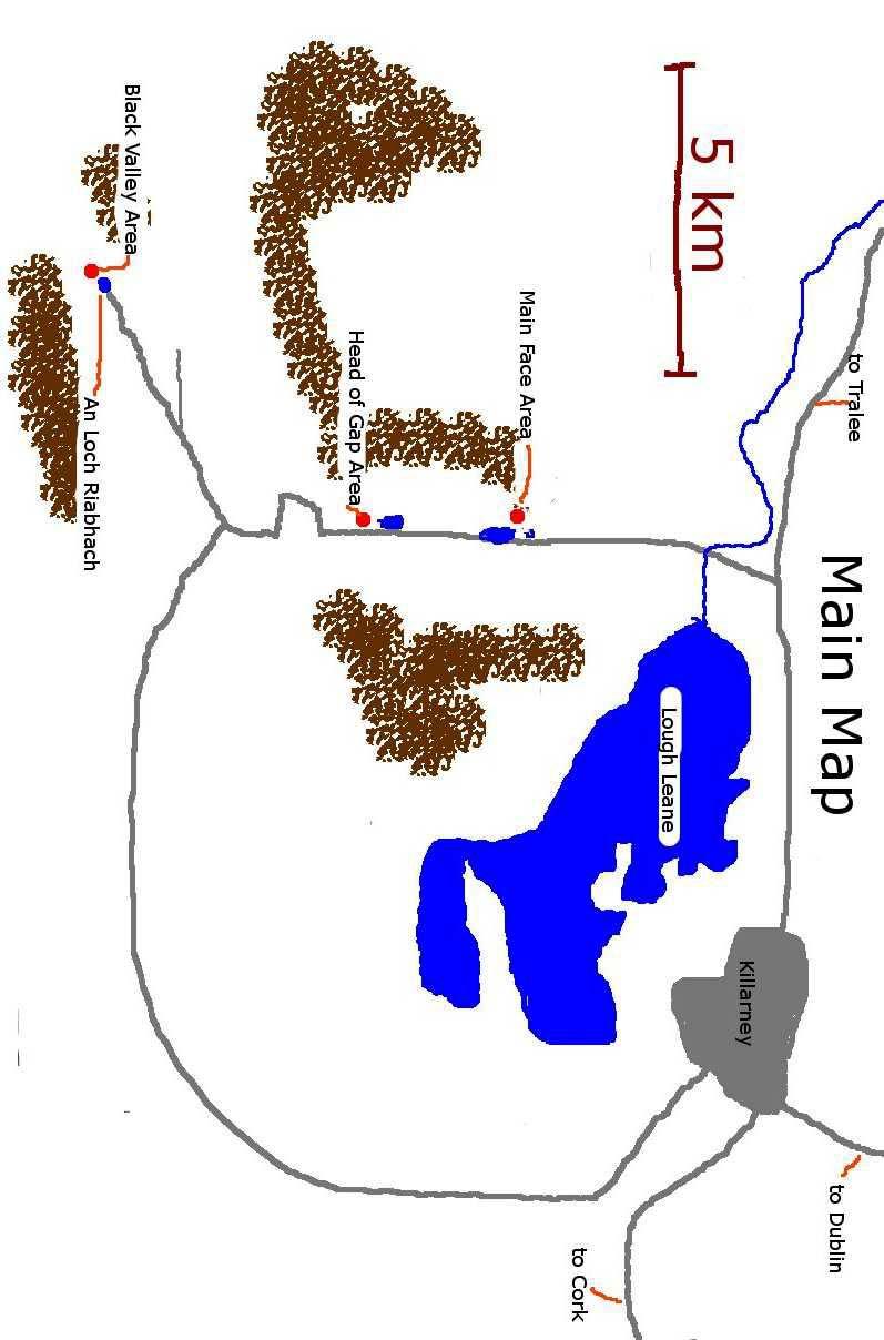
3 Introduction This is a basic guide for the some of the bouldering that has been done in the Gap of Dunloe and the Black Valley, in Co Kerry. It is not comprehensive and many of the problems have been left out. Grades, maps and descriptions may be inaccurate. It is really a preliminary guide before we put a better one together, with the intention of letting people know about the areas and how to get to them. Notes on this Guide. Equipment: A bouldering mat is essential, two mats with spotters are recommended. Many of the landings are rocky and uneven. Boots are also recommended as the walk-ins tend to be boggy. Access: Access can be touchy with the farmers. Please be courteous and respectful to locals you meet. Don t park your cars in lay-bys intended for cars to pass each other. If going through a gate then open and close it, do not climb over it. If possible do not bring dogs with you, especially in spring/early summer when it is lambing season. If you are asked to leave any area then explain to the farmer what you are doing, and ask if you can stay. If he/she still wants you to leave then do so quietly. The Main Face area never has any problem with access and can be used as a fallback. Maps: The maps were drawn by overlaying images from google earth and while the outlines of boulders and cliffs 3
4 are not entirely accurate, the maps are definitely good enough to find the boulders. First Ascents: First ascents are mostly unrecorded. Many people have bouldered in the Gap, most (but not all) of whom I would know. If one of your first ascents has been named and you feel particularly strongly about it then please let me know in writing and it can be changed in time for the next edition. Names of Boulders/Routes: I named a lot of boulders and routes while putting this guide together. I reasoned that it would be easier for people to reference them. These names can be changed. Grades: Fontainbleau system. Unfortunately are a bit all over the place, So let it be known if you feel they are wrong. Geology: Old red sandstone, look it up on the internet if you are interested. It is an excellent rock-type for climbing. When it is well weathered the friction is almost too good The rock is generally very solid and the boulders rarely require cleaning or brushing. Descriptions: Routes are described in the format of Number>Name>Grade>Sit-start/standing>Desciption. With a corresponding picture. SS means sit-start. A question mark (? ) means I m not entirely sure. If I don t know then I leave a blank space. Much thanks to my lovely assistant Brian McSweeney! 4
5 Main Face Area. 5
6 Main Face Area This is a great area. The routes tend to be shorter with better landings and not as much highballs. Its also close to the road and the crags. There are lots of easier problems about the place that are not described and there is potential for a significant number of new problems and variations. Parking can found beside the Brennans Leap roadside crag (room for 3 cars). Or else just past the bridge between Black Lake and Echo Lake, (room for 4/5). The bouldering is about a 10 minute walk from the road. I ve described to boulders from Elbow across to An Puc Fada (south to north) 6


7 Elbow Boulder M1: Four B Double D, 5, SS, up the left side of the arete on jugs. M2: 5, SS?. M3: Left Elbow, 5, SS. M4: The Craic Attack, 5, SS, use edges on the sides or a pair of meaty fists! M5: Right Elbow, 5, SS. The Coffin M6:?, SS. There are a few variations on this, some using the two side boulders, others without. Watch out for a small loose block near the roof edge. 7


8 Micks Magic M7: 5 M8: Micks Magic, 6c, use underclings & poor footholds reach/slap for the slopey edge. Good Problem. M9: 5 Carraig Eire, so called cos it looks like Ireland! M10: West Coast, 5 M11: Mizen to Malin, 6a+, This is a highball with the hard moves near the bottom, Good problem but watch the landing! M12: The Pale, 5, again watch the landing. There are a number of easier problems on the back of this. 8

 SS.")
9 Hup-Hup M13: Hup-Hup. 6b+, SS. Good strenous problem with a hard start. The other line in this photo is a problem where you throw a heel hook out right to enable you to make a long move/mantle. The landing is terrible though and so is not recommended. The Boar M14: 5, SS, traverse out along the lip. M15: Snout Wrestling, 6b+ (using the back boulder that has the green circle) SS. The route normally finishes with a dyno to the lip, good fun. This line without the back boulder is a project estimated at 7c. M16: An Collach, 6b, SS. Good line. 9


10 Piglet M17: 4 M18: 4 M19: 5 M20: An Srón, 6b, SS. Great prob using an interesting sloper. It requires good feel as opposed to brute strength to get up. Croc, backside. M21: 5, SS M22: 5, SS M23: Pobal na Páirti, 6a, SS, crimpy M24: 4, SS. 10


11 Croc, so called because of the scaly quartz pattern on this side. M25: Jug arete, 4, SS,. M26: 6b. SS, 5 from standing. M27: Scale Scaler, 6c, SS Reading Problems M28: Reading Problems, 6a+, SS. An excellent problem that can be jammed or laybacked, it finishes with an awkward flop of a top-out 11


12 An Puc Fada M29: An Puc Fada, 6b, SS. Up along the juggy rail, then make a long throw out to the rounded arete, re-arrange the feet to get to the jug and then finish up the arete. Brilliant. M30: Juan is a Langer!, 7a+/7b, SS. Same start as an Puc Fada but go right and power up the wall on small holds. The Anvil M31: 5, Traverse out and back along the lip. 12
13 Watchtower The guide for this area can be found on However access is very bad here at the moment and we would ask people not to go to this area at all. Head of the Gap Area This area is the least developed of the three. There is a lot of potential for new routes, especially as one walks back towards Auger Lake. The boulders here tend to be large and two mats are especially recommended for this area. Because of its position in a deep valley, it tends to be shady and windy and would be a good option during the summer. There is room for two or three cars to park 30m past the Turnpike boulders. If there is no space here then it would be best to park back 0.5km back down the hill beside the old barracks. All the boulders are within 200m of the road. 13
14 14

15 Turnpike Boulders H1: 6b+, a low start in the hole makes this route good & long. You climb up the arete on small positive holds until a big dyno/throw is needed to grab a big flat edge. It can also be done from sitting at 6c/6c+. Great problem. H2: Edge of the Onion, 6a+, Up along the arete until a scary mantle. H3: Roadkill, 6b, from standing grab the sideways jug and power up. H4: Kenton is a Langer, 6c. SS. Up the right arete until you reach a line of holds leading out across the face. Awkwardly reach the aforementioned sideways jug, swing your feet down and then power as for Roadkill. Excellent H5: Right Arete, 6a, SS H6: 4, fun moves up the slab. The green lines mark a Dyno at 6c? 15


16 H7: Under the Red Sky, 6c+, Up the arete, watch the landing! Deadly highballs possible on the right Four Boulder This boulder is 100m west of the Turnpike boulders. It has three fun little problems H8: 4 H9: Yoda Yoga, 4 H10: 4 16

.")
17 The large boulder in the background has no problems on it, and is another candidate for serious highballs. Big Big Boulder- This is the back of the Big Big boulder, which is unmissable from the road. While we have climbed on the front of this boulder the landings are diabolical so I decided to leave it out. H11: 4, fun slab H12: 4, funner slab This boulder is just to the left of Big Big (as seen from the road). H13: 4 H14: 4 The line in the bottom right of the picture is a steep 6a+ with a SS. 17

18 Hex Boulder This boulder has really good friction. The huge highball slab can just be seen in this picture on the right. H15: 6b, up the seam & on to the slab. H16: Marcels Problem, 6c, up the face finishing with a big slap H17: Help the Blind, 6b, SS H18: 5 H19: Batman, 4. H20: 5 18
19 Black Valley Area The Black Valley has a number of outstanding problems in a beautiful setting. There is again a large potential for new routes but not so many untouched boulders. The boulders here tend to be very large and relatively spread out (100m between boulders). The farmer who owns the land seems to reasonable enough. He is used to walkers crossing his land. Again please open and close the three or four gates you will have to go through, you have to walk past his sheep pen on the way in so if he is there then be polite and not too loud. For this area there should be no dogs. Parking for four to five cars can be found just past a concrete bridge. This bridge is literally 40m from the track shown on my map. I describe the Flashdance area first, then back along to the Wave & Jurgen Myers. 19
20 20

21 Flashdance A great highball slab B1: Left Feet, 6a, up the lefthand side of the slab. B2: Flashdance, 6a+, A brilliant line with a psychologically difficult move right at the top. Its quite high so two mats on top of each other required along with a couple of astute spotters. Highly recommended. 21


22 Cracked B3: Cracked, 5?, fun little prob that can also be done from SS Gritty. Its exactly that! B4: Grated Cheese, 6b+, SS. Start with one hand inside and the other on the lip. Imagine your way around on to the slab. Astounding friction. B5: Gritty, 6a+, get up the nose from a standing start 22


23 This problem is on a wall 100m NE of Flashdance. B6: Little Miss, 6c. Sequency problem, finishing with a deadpoint from a small hold to a good jug. Rock & Lock B7: Rock & Lock, 6a+, SS B8: Balance, 6b, SS 23

24 Distant Faces B9: Distant Faces project, estimated at 7b. Escape out left at halfway is possible giveing a balancey problem of 6c. The gem would be to stick to the central line. B10: Arete, right side. 6a+, this is quite high so watch the landing. B11: Underbalance, 6b+, a balancey problem going up underclings, again watch the landing. B12: Half, 5+/6a. A shorter line on the right. B13: 6a, SS B14: 5+ The green circles and line show a 6b+ Dyno. 24


25 Shout B15: 6a+, crimpy problem that is not topped out B16: Shout!, 6b+. SS. Powerful problem, start with left foot on small hold and right leg dangling beneath the boulder. Brute your way up to an awkward top-out. B17: The Kerry Wave, 5. Start low on the left and heel hook your way along to the apex, then mantle out. The Bone Yard Arete is on the back of the Kerry Wave. 25

26 The Bone Yard Arete The best bouldering problem in the Black Valley and possibly the entire Gap of Dunloe area. It has two variations which both start from sitting The green circle shows a small boulder that may or may not be used for a footlock at the start. B18 Var: Bone Yard Arete, 6c+, SS. Using the small boulder for a footlock, start with your hands on a large down-sloping hold. Sequence your way up and out on to the slab, using a bewildering amount of different handholds. The trick is in figuring out which to use and which to skip. Brilliant. B18: From Cali with Love, 7b, SS. The same problem, except without using the footlock. Instead a terrible heel-hook must be used, this makes the start sloping handhold much worse. First ascended by Damon Corso. 26


27 This problem is on the side of the Jurgen Myers boulder. B19: Ziggy, 6a+, Good prob. B20: 6b+, SS. Powerful start, awkward finish. B21: 7a+, SS. Bit awkward to start with the small boulder in the way. B22: 6a, SS. Start on big jugs and get yourself out and up the slab. The End 27
Topos curated by The Climbing Academy, Ring Road Boulders
 Ring Road Boulders Location and Approach There are various approaches to get to the bouldering. The one described here takes about 10 minutes. Park on Hartford drive, approached by turning right off the
The Nest Bouldering Guide By Marc Eveleigh Updated March 24 th, 2016
 The Nest Bouldering Guide By Marc Eveleigh Updated March 24 th, 2016 Introduction The Nest is a small bouldering area set in a neat section of canyon with a rushing stream. Originally called Mophead a
CRANBERRY. Introduction
 Introduction Introduction The Cranberry Boulders are a group of 60 problems set in a beautiful mossy forest above the Cranberry Creek. The boulders are located approximately 36km south of Revelstoke on
The Flu sits on a west facing hillside and doesn t get as much sun as the other areas. The stone tends to hold moisture much longer and becomes
 The Flu sits on a west facing hillside and doesn t get as much sun as the other areas. The stone tends to hold moisture much longer and becomes brittle when wet. So please refrain form climbing in the
4 - Flight of the Osprey - V1+ * Climb the nice arête on the far right from a sit start on an awesome side pull feature. Fun!
 Cave The first boulder(s) you encounter on the trail down, 2 minutes from the car. Home to some of the best boulder problems in Nelson, a little here for everyone. The Axe traverse should not be missed!
Ilkley Buckstones. Ilkley Buckstones. Unknown Stones. Climbs 60 (Font 4 to7b). Altitude 390m asl. Faces All directions but mostly north.
. Altitude 390m asl. Faces All directions but mostly north.") Ilkley Buckstones Climbs 60 (Font 4 to7b). Altitude 390m asl. Faces All directions but mostly north. Other condition info: A group of boulders set high on the moors above Ilkley and the Aire Valley but
Ilkley Buckstones Climbs 60 (Font 4 to7b). Altitude 390m asl. Faces All directions but mostly north. Other condition info: A group of boulders set high on the moors above Ilkley and the Aire Valley but
Hong Kong Bouldering. Steven Yip treading a Rocky Road (V6). Photo: Stuart Millis. HongKongClimbing.com. Page 36
. Photo: Stuart Millis. HongKongClimbing.com. Page 36") Hong Kong Bouldering Steven Yip treading a Rocky Road (V6). Photo: Stuart Millis Page 36 S hek Lung Kung General A fine set of boulders on very high friction rock. This area has the added bonus of a stunning
Hong Kong Bouldering Steven Yip treading a Rocky Road (V6). Photo: Stuart Millis Page 36 S hek Lung Kung General A fine set of boulders on very high friction rock. This area has the added bonus of a stunning
Burley Moor Crags THE BURLEY MOOR CRAGS. Coldstone Beck Crag SE Unknown Stones Page 1
 THE BURLEY MOOR CRAGS SE145451 Coldstone Beck Crag is the obvious quarried area at the top of the footpath leading up from the parking spot on the Moor Road between Burley Woodhead and Ilkley. There is
Keeper Crack Area. Brimham Northern Edges. Unknown Stones. Climbs - 20 Altitude 270m Faces North, South, West and East
 Keeper Crack Area Climbs - 20 Altitude 270m Faces North, South, West and East Other condition info: Recently developed and redeveloped quality bouldering in the Keeper Crack area of Brimham North Edges.
12 Plantation Crack Area.
 12 Plantation Crack Area. There has always been some good, though limited, bouldering at Plantation Crack. Over the years this has been developed and now adds up to a fairly substantial area spread along
Lund Stones. Lund Stones. Unknown Stones. Climbs - 40 Altitude 300m Faces South, South West Grid ref SE
 Climbs - 40 Altitude 300m Faces South, South West Grid ref SE 175713 Lund Stones Other condition info: An isolated edge with good rock, that, once cleaned, reveals fine and distinctive problems, across
Long Crag. Long Crag. Unknown Stones. Other condition info: Excellent rock and a spectacular position make the boulders wellworth
 General Information OS Ref. GPS See Map See Map Long Crag Long Crag Other condition info: Excellent rock and a spectacular position make the boulders wellworth a visit. Altitude Aspect Conditions 400m
Eskdale Granite Bouldering Copyright Philip Wake
 Eskdale Granite Bouldering Copyright Philip Wake Directions (from the south) From the M6 motorway leave at junction 36 for Kendal/Lakes. Follow signs for Barrow. Before you reach Barrow, turn right to
Hong Kong Bouldering. Lai Chi Wai takes flight on Superhardness (V6). Photo: Stuart Millis HongKongClimbing.com. Page 42
. Photo: Stuart Millis HongKongClimbing.com. Page 42") Hong Kong Bouldering Lai Chi Wai takes flight on Superhardness (V6). Photo: Stuart Millis Page 42 L in Fa Shan General A superb set of boulders with problems of exceptional quality above generally flat
Hong Kong Bouldering Lai Chi Wai takes flight on Superhardness (V6). Photo: Stuart Millis Page 42 L in Fa Shan General A superb set of boulders with problems of exceptional quality above generally flat
Bear Mountain Bouldering A guide by Trent Hoover
 Bear Mountain Bouldering A guide by Trent Hoover The windmills of the Bear Mountain Wind Farm are a distinctive feature of the Bear Mountain climbing area 1 Bear Mountain Bouldering (August 2012) Bear
1/ Clatterjack 7a * SDS under right side of the roof. Out to lip, left to the arête and up before stepping back right to finish
 14 Crow Crag The potential of Crow Crag has gradually come to light though lines still remain unexplored. Despite the woodland location the excellent rock dries pretty quickly and there are some strong
Crimpy Roof Hare Heads
 Crimpy Roof Hare Heads General Information Grid Ref SE 213 651 Parking GPS 54.08003-1.676450 Altitude 272M Aspect All SW Conditions Quick drying, afternoon sun and all the wind Plod Time 5 Mins Landings
CAPE ST. FRANCIS SEASIDE BOULDERING IN THE INDEPENDENT STATE OF THE EASTERN CAPE. 1st Edition NIEL MOSTERT
 CAPE ST. FRANCIS SEASIDE BOULDERING IN THE INDEPENDENT STATE OF THE EASTERN CAPE 1st Edition NIEL MOSTERT On the Cover: Martin Renz on Spongebob (7A), The Cove Cape St. Francis Seaside Bouldering in the
Brimham - The Central Area
 Brimham - The Central Area A fine circuit with some of the most travelled problems at Brimham and some neglected goodies. A varied array of edge and block challenges. Walking up the main track towards
Bouldering Guide. The Shrine. February 06, 2010 Jason Allemann Kristal Dubois.
 The Shrine Bouldering Guide February 06, 2010 Jason Allemann Kristal Dubois www.topout.org The Shrine contains the largest concentration of developed boulders in the Ottawa/ Gatineau region. Most of the
Little Simon s Seat. Little Simon s Seat. Unknown Stones. Climbs 32 Altitude 450m a.s.l. Faces North West
 Climbs 32 Altitude 450m a.s.l. Faces North West Other condition info: A jumble of boulders that are composed of good, silvery grit, set high on Simon s Seat. Problems have been done over the years but
EAGLE PASS. Introduction
 Introduction Introduction The Eagle Pass Boulders are located west of Revelstoke, BC above the Trans-Canada Highway on the south flank of the aptly named Boulder Mountain. Development started in the summer
House Area: Frank Slide Bouldering
 House Area: Frank Slide Bouldering Trent Hoover and Kyle Marco The House Boulder Area, located at the northwest edge of Frank Slide, is one of the most easily accessible sectors at the Slide. From a large
Doolin - Bouldering DOOLIN B OULDERING. Al Sarhan on Fireworks 7b. Al Sarhan on Fireworks 7b
 Doolin - Bouldering replace front.pdf 14/09/2007 09:29:23 Al Sarhan on Fireworks 7b Doolin - Bouldering Al Sarhan on Fireworks 7b This is sample pdf download from the upcoming Burren and Aran Island Rock
Rowantree Tor. Rowantree Tor. Unknown Stones. Climbs - 50 Altitude 300m Faces South west
 Climbs - 50 Altitude 300m Faces South west Rowantree Tor Other condition info: Set in a fine position overlooking the upper section of Fosse Gill and at the end of Rowantree Crag Ridge, the area consist
Yeadon Crag. Parking and Approach: Boots or wellies are a must as the approach has a small, unavoidable boggy patch.
 Yeadon Crag Yeadon Crag is the southernmost end of the crag series which runs south from Sypeland and is unquestionably one of the most significant Wild Bouldering developments of recent years in Yorkshire.
The Southern Pinnacles. Go uphill a short way along the path. Just after it levels out and in a depression down to the left is:
 Brimham South Area This 2-part circuit takes in the Southern Pinnacles and blocks that lay alongside the snaking Pinnacles Path. This starts at the Main Car Park and follows it as far as the obvious grassy
Lost Causes. A Climbing Guide to the Mesilla Valley. Installment 2.4. Dona Ana Mountains Pizza Boulders. By: Charles Cundiff
 Lost Causes A Climbing Guide to the Mesilla Valley Installment 2.4 Dona Ana Mountains Pizza Boulders By: Charles Cundiff Pizza Boulders Legend has it that back in the day (somewhere between 1960 and 1986)
Eastby. Eastby. Climbs 50+ Altitude 320m Faces South
 Eastby Climbs 50+ Altitude 0m Faces South Other condition info: Good all year venue. The crag is a big sprawling affair with many good areas. Generally the problems are quite high and some landings are
Far Crag. Far Crag. Unknown Stones. Heather Top Wall. Other condition info: A fine little bouldering area in a pleasant location.
 Far Crag General Information Other condition info: A fine little bouldering area in a pleasant location. It OS Ref. SE152637 faces west and provides a number of very GPS good problems. Ideal for a few
Kangaroo Point Bouldering Guide
 Kangaroo Point Bouldering Guide Introduction KP is the home of Queensland finest contrived boulder problems. So if you don t like contrived problems, please stop reading this page. The grades we have given
The First Wall is a good place to get warmed up with several short pleasant wall climbs and one tricky sitter.
 Gate House Crag This is an excellent and long overlooked moorland bouldering venue with good rock and flat landings. It is generally south facing, though with walls of varying aspect, and an easy 25 minute
A popular area with Joker s Wall offering steep and fingery problems for the strong with a few other good bits here and there.
 Cubic Area Brimham A popular area with Joker s Wall offering steep and fingery problems for the strong with a few other good bits here and there. Parking and approach Easily accessible in 2 minutes from
High Crag (Stump Cross)
") High Crag (Stump Cross) Climbs - 25 Altitude 410m Faces North West Other condition info: Smart little edge and boulders with a useful collection of routes and problems in a convenient and fine location.
High Crag (Stump Cross) Climbs - 25 Altitude 410m Faces North West Other condition info: Smart little edge and boulders with a useful collection of routes and problems in a convenient and fine location.
Twin Towers. Unknown Stones. Twin Towers. Climbs - 26 Altitude 230m Faces North West
 Climbs - 26 Altitude 230m Faces North West Twin Towers Twin Towers A small crag, which makes up what it lacks in volume with the striking quality of its highball routes each constructed of the finest Slipstones
Hudeshope Pennines
 408 Pennines 409 Monk's Moor Boulders OS Landranger Sheet: 92 Map Reference: NZ962289 Aspect: West to North West Altitude: 560m Approach: 30 minutes Mod - Severe 0 HS - HVS 0 E1 - E3 0 E4 and above 0 Bouldering
Jenny Binks Boulders
 Climbs - 20 Altitude 370m Faces South Jenny Binks Boulders Jenny Binks Boulders Other condition info: A fine, quite high wall of perfect grit that is very Slipstones like and faces south in a fine position
WaihekeIsland STU KURTH ON THE TIGER V2 BYSTERLINGANDSTEADASSOCIATES
 WaihekeIsland BOULDERGuide STU KURTH ON THE TIGER V2 BYSTERLINGANDSTEADASSOCIATES PROBLEMSBYAREA FIRSTROUNDAREA First Round Boulder 1. Sleepy Girl V0 PAGE 08 2. First Round V0 PAGE 08 Chunky Boulder 3.
ENGLISHMAN. Introduction
 Introduction The Englishman Boulders are a collection of roughly 150 problems situated on the banks of Englishman Creek. The boulders are located approximately 20km west of Revelstoke on the 3 Valley/
Gate House Crag. Unknown Stones. Gate House Crag (A4 Feb 17)
") Gate House Crag This is an excellent and long overlooked moorland bouldering venue with good rock and flat landings. It is generally south facing, though with walls of varying aspect, and an easy 25 minute
Gate House Crag This is an excellent and long overlooked moorland bouldering venue with good rock and flat landings. It is generally south facing, though with walls of varying aspect, and an easy 25 minute
Tan y Grisiau Boulders
 Tan y Grisiau Boulders Area: Blaenau Ffestiniog Aspect: South Rock type: Rhyolitic Tuff Approach: 10 15 minutes Altitude: 400m OS grid ref: 679 454 Hippocampus New Noise 8A/+ 8A/+ Flick of the Wrist 7C/+
Routes Third Friend Lucky E2 5c 8m * The right edge. Problems Green Wing V4 * A varied low traverse from right to left.
 West Chevin Boulders Situation and Character A woodland situation, just below the Chevin summit. It is fair to say these boulders will never achieve classic status due to the prevailing greenery (but don
Below is an example of a well laid-out template of a route card used by the Sionnach Team which is a good format to begin with.
 Route Card A route card is used as a navigational aid to hill walkers by setting out a step by step plan for an intended hike. It is good practice to make out a route card before every hike you or your
Sigsworth Crags. Unknown Stones
 Crags Crags Amongst the most significant Wild Bouldering developments of late, this fine collection of boulders, set above the hamlet of Wath, enjoy a stunning outlook over Upper Nidderdale. The walk in
Clint Quarry History Overview Approach
 Clint Quarry History The quarry has spiked the interest of various people over the years though recent additions by Steve Dunning, Dave Sutcliffe, Neil McCallum, Steven Phelps and Martin Whitton have renewed
2017/08/27. Derek Marshall 1
 0/0/ Derek Marshall General St Francis is a seaside fun-in-the-sun holiday resort town. Bouldering is part of the fun, keep it fun! Directions & Map Get smart, use Google to get there! http://www.easterncaperockclimbing.co.za/location/cape-st-francis
It s going to be minute clean up minimum. You re going to be running late today for sure.
 ***IMPORTANT DISCLAIMER*** Please DO NOT copy and paste directly to your site without changing the article considerably to suit your niche site's original angle (Google WILL penalize duplicate content)
Waterproof Debris Shelter
 Bushcraft Video Series: David Styles, creator of 'Deep Nature Mentoring' presents Waterproof Debris Shelter Transcript Of Video 1. How Do We Make A Debris Shelter? Today we are going to learn about how
Axe and Saw Permit: Safe Use of Axes
 Page 1 of 7 Objective: The objective of this workshop guide is for the Scout Leader and/or Scout youth to be able to describe and demonstrate safe use of the Axe. Axe or Hatchet: What s the difference?
Lad Stones Bouldering. By Greg Chapman
 Lad Stones Bouldering By Greg Chapman Introduction Approach & Overview Map Aspect Situated on the southern flanks of Wetherlam, east of Levers Water and the Coppermines Valley, the mighty Lad Stones sit
McKenzie Pond, New York This guide book originally came into existance merely as a means to make discussing the bouldering here easier. It was not int
 M c K e n z i e b o u l d e r i n g P o n d g u i d e a l s o k i P p Y g R o o V e R k i D d o s u a V e McKenzie Pond, New York This guide book originally came into existance merely as a means to make
Setting Your Mirrors
 Setting Your Mirrors Mirrors are crucial to the safe driving of an RV. After all, the RV is usually significantly larger (longer, wider, and higher) than your normal daily vehicle. So even if you do not
(west) onto Charleston Boulevard. Drive 16 miles on Charleston and turn right into Red Rock
 onto Charleston Boulevard. Drive 16 miles on Charleston and turn right into Red Rock") Hike: North Peak and Ice Box Overlook up and back Trailhead: 2.5 miles up the Rocky Gap Road not mark Distance: 5 miles round trip Elevation gain: 2,694 feet Elevation Peak: 7,094 feet Time: 3 to 5 hours
Hike: North Peak and Ice Box Overlook up and back Trailhead: 2.5 miles up the Rocky Gap Road not mark Distance: 5 miles round trip Elevation gain: 2,694 feet Elevation Peak: 7,094 feet Time: 3 to 5 hours
User s Manual Trampoline 8
 User s Manual Trampoline 8 Model! WARNING Read all precautions and instructions in this manual before using this equipment. Save this manual for future reference. Maximum user weight 17 lbs. ASSEMBLY IMPORTANT
CENTER PIVOT TRACK MANAGEMENT OPTIONS
 Proceedings of the 28th Annual Central Plains Irrigation Conference, Kearney, Nebraska, February 23-24, 2016 Available from CPIA, 760 N. Thompson, Colby, Kansas CENTER PIVOT TRACK MANAGEMENT OPTIONS Steven
Canopy Tour & Aerial Adventure Course Selection Guide
 Canopy Tour & Aerial Adventure Course Selection Guide The Adventure Network offers a wide range of Canopy Tour and Aerial Adventure Course options for any size program. Whether your goal is to create a
Mt. Sneffels (from Yankee Boy Basin) - A Cool Fourteener
 - A Cool Fourteener") Mt. Sneffels (from Yankee Boy Basin) - A Cool Fourteener Difficulty: Difficult Class 3 Exposure: Summit Elev.: 14,150 feet Trailhead: Yankee Boy Basin Climbers: Rick Crandall; Shan Stuart; Laura Welch
Mt. Sneffels (from Yankee Boy Basin) - A Cool Fourteener Difficulty: Difficult Class 3 Exposure: Summit Elev.: 14,150 feet Trailhead: Yankee Boy Basin Climbers: Rick Crandall; Shan Stuart; Laura Welch
Mt. Eolus and North Eolus
 Mt. Eolus and North Eolus Difficulty: Class 3 Exposure: Summit Elev.: Mt. Eolus: 14,083 feet N. Eolus: 14,039 feet Camp Elev.: 11,100 feet Elevation Gain: 3,200' starting at Chicago Basin 6,300' starting
Sponsored by. statestreet.com
 /STATESTREETISLANDWALK #ISLANDWALKJSY Sponsored by statestreet.com Important Information If you forget everything else PLEASE remember the following.» Remember to check OUT of every checkpoint» If you
Darwin s gigantic blunder
 Trail Darwin s gigantic blunder Explore how ice shaped the landscape and why Charles Darwin made a nice mess of Glen Roy Time: 1hr 10 mins Distance: 2 miles Landscape: rural At Glen Roy a curious feature
CAHSEE on Target UC Davis, School and University Partnerships Student Workbook: Writing Applications Strand
 The Hiking Trip I never wanted to come on this stupid old hiking trip anyway! His voice echoed, shrill and panicked, across the narrow canyon. His father stopped, chest heaving with the effort of the climb,
A Basic Manual on Knife Throwing
 A Basic Manual on Knife Throwing By J. B. Wood Illustrated by Roy Pelz The author of this manual, Mr. J. B. "The Old Man of the Hills" Wood (Kentucky) is a well known writer on firearms and the outdoors.
11 Bat Buttress. Do not access this crag by crossing the wall from the National Trust Estate.
 11 Bat Buttress Bat Buttress is a series of walls and block set amid a bigger edge that has some fine routes. The rock is generally very good and the south facing aspect means it gets plenty of sunshine.
Foreword. Loch Ness from the summit of the High Route
 Foreword 4 The Great Glen Way runs for just over 77 miles (125 km) from Fort William to Inverness. It starts beside Britain s highest mountain, Ben Nevis; follows its greatest geological fault along the
3rd GRADE MINIMUM CONTENTS UDI 1: LANDSCAPES (5)
") 3rd GRADE MINIMUM CONTENTS UDI 1: LANDSCAPES (5) DIFFERENT LANDSCAPES A landscape is all the things that we see in a place. There are different types of landscapes. Mountain landscapes have mountains and
3rd GRADE MINIMUM CONTENTS UDI 1: LANDSCAPES (5) DIFFERENT LANDSCAPES A landscape is all the things that we see in a place. There are different types of landscapes. Mountain landscapes have mountains and
Carrock Fell Bouldering. By Greg Chapman
 Carrock Fell Bouldering By Greg Chapman N Introduction: Aspect & Conditions Quietly nestling on the Eastern flank of a remote North Lakes fell side lies a truly magical boulderering paradise. Countless
Kindergarten-2nd. July 4-5, Joseph. Genesis 37-48; Jeremiah 29:11. God wants our obedience.
 Kindergarten-2nd July 4-5, 2015 Joseph Genesis 37-48; Jeremiah 29:11 God wants our obedience. Connect Time (15 minutes): Five minutes after the service begins, split kids into groups and begin their activity.
West Kingdom Thrust and Throw Example Weapon Construction
 West Kingdom Thrust and Throw Example Weapon Construction Javelin Construction method by Dauid ap Morgant Dinefwr - Axe construction method by Owen Flechyr Javelin Construction Method Parts: 1- Five foot
ID: 283 Distance: 6.2 miles Height gain: 500 Metres Map: Explore OL 19 Contributor David and Chris Stewart
 Walkingworld Wild Boar Fell ID: 283 Distance: 6.2 miles Height gain: 500 Metres Map: Explore OL 19 Contributor David and Chris Stewart Features Birds, Great Views, Hills or Fells Description: Wild Boar
Mount Daly a Most Prominent Peak via South Ridge
 Mount Daly a Most Prominent Peak via South Ridge Difficulty: Class 3 Exposure: Exposed in places along the ridge Summit Elevation: 13,305 Elevation Gain: 4100 from trailhead; 1800 from Capitol Lake camp
Tiger Mountain State Forest:
 98 60 hikes within 60 miles: SEATTLE 20 Tiger Mountain State Forest: West Tiger Mountain Three Loop i KEY AT-A-GLANCE INFORMATION Length: 5.1 miles round-trip Configuration: Loop Difficulty: Moderate difficult
Short Wall Hog's Back Caves 1. East Land 1332 and 2. King of Swing 1. Unnamed YankOnThis.com 2. Unnamed Lost and Alone Buttress 3. K7 4.
 12 Short Wall Short wall between black slabs and the buttress. East Land 1332 SDS - Start left of big bowl shaped hueco on large low pocket, traverse right into hueco, and then straight up. 2. King of
Wicklow Mountains Path Survey
 Wicklow Mountains Path Survey Glenmacnass Tonelagee Start to Finish: O 114 030 to O 085 016 Altitude (lowest highest): 370m 817m Weather: Sunny day, hot Access: Military Road, Glenmacnass Surveyed by:
Self-Guided Walk Langdale Pikes. Start & Finish: NT car park (free to members) at Sticklebarn - on the right just beyond the New Dungeon Ghyll hotel.
 at Sticklebarn - on the right just beyond the New Dungeon Ghyll hotel.") Self-Guided Walk Langdale Pikes Key Information These mountains form a collection of spires and cliffs on the north side of Langdale. This walk visits four of the main tops Pavey Ark, Harrison Stickle,
Self-Guided Walk Langdale Pikes Key Information These mountains form a collection of spires and cliffs on the north side of Langdale. This walk visits four of the main tops Pavey Ark, Harrison Stickle,
The Cleo s Bath North Side Hike
 The Cleo s Bath North Side Hike This hike is a cross-country hike from Pinecrest Lake to the north side of Cleo s Bath. It is quieter and much less crowded than the normal route, which goes up the south
PERUVIAN ANDES ADVENTURES. ARTESONRAJU CLIMB 6025m (19767 ft) Grade: D+ to TD/ Technical. Routes: The two routes to climb Artesonraju are;
 Grade: D+ to TD/ Technical. Routes: The two routes to climb Artesonraju are;") PERUVIAN ANDES ADVENTURES ARTESONRAJU CLIMB 6025m (19767 ft) Grade: D+ to TD/ Technical Routes: The two routes to climb Artesonraju are; *Via the Paron Valley South East Ridge 5 days (option for 6 with
PERUVIAN ANDES ADVENTURES ARTESONRAJU CLIMB 6025m (19767 ft) Grade: D+ to TD/ Technical Routes: The two routes to climb Artesonraju are; *Via the Paron Valley South East Ridge 5 days (option for 6 with
Guide Book Excerpts. Wham Ridge 2006
 Guide Book Excerpts Wham Ridge 2006 Approach: Molus Lake / Elk Park / Vestal Creek Roach and Roach Description Take the Durango & Silverton Narrow Gauge train from either Durango or Silverton and get off
Skiing and Snowshoes on Un-groomed Fernan Saddle Terrain
 Skiing and Snowshoes on Un-groomed Fernan Saddle Terrain Three ski or snowshoe routes are available from the Fernan Saddle Parking Lot which either do not cover routes ordinarily groomed for snow machine
Location: Height: Access: Distance: Elevation: Season: Difficulty: Lat/Long: Directions:
 Upper Eagle Falls Upper Eagle Falls (~20 ft.) is a short hike up from the roadside at the Eagle Falls picnic area. It is very difficult to get a parking spot here during the day, so it is recommended to
COSTA BLANCA MOUNTAIN WALKERS - WALK DESCRIPTION. Visit for more walks descriptions in Spain
 COSTA BLANCA MOUNTAIN WALKERS - WALK DESCRIPTION Visit www.walksinspain.org for more walks descriptions in Spain Walk description originally prepared by:- Ralph Phipps Last Updated 25th Sep 2015 Title
Girrakool to Wondabyne station
 Girrakool to Wondabyne station 4 hrs Hard track 9.5 km One way 4 438m This walk starts from the Girrakool picnic area and winds south, through the Brisbane Waters National Park. The walk crosses some long
Typical avalanche problems
 Typical avalanche problems The European Avalanche Warning Services (EAWS) describes five typical avalanche problems or situations as they occur in avalanche terrain. The Utah Avalanche Center (UAC) has
Measurements, Weight and Pictures Please read all of this, will take you 5 minutes. : )
") Measurements, Weight and Pictures Please read all of this, will take you 5 minutes. : ) Below is the information for how you submit your measurements to track your progress and your pictures for the 6-week
Measurements, Weight and Pictures Please read all of this, will take you 5 minutes. : ) Below is the information for how you submit your measurements to track your progress and your pictures for the 6-week
Erskine Creek via Pisgah Rock and Jack Evans
 Erskine Creek via Pisgah Rock and Jack Evans 4 hrs 30 mins 7.1 km Circuit Very experienced only 6 421m This walk visits some great lookouts and explores the lower section of Erskine Creek. Most of the
Installation manual. Awning. V480 Cannes
 Installation manual Awning V480 Cannes Installation manual awning V480 Cannes Content 1. Awning * 2. Wall supports 3. Extra support(s) (with an awning bigger than 350 cm) 4. Mounting plates (optional)
Note: Coordinates are provided as Universal Transverse Mercator UTM Zone U21, North American Datum 1983 (NAD 83).
.") Northern Traverse Route Description The Northern Traverse (formerly the North Rim Traverse) is an unmarked and rugged backcountry hiking route. It is known be a demanding hike, because of its terrain and
Northern Traverse Route Description The Northern Traverse (formerly the North Rim Traverse) is an unmarked and rugged backcountry hiking route. It is known be a demanding hike, because of its terrain and
Deborah Padovan Tuesday, September 05, :41 PM Steve Padovan FW:
 Attachment 9 Steve Padovan From: Sent: To: Subject: Deborah Padovan Tuesday, September 05, 2017 4:41 PM Steve Padovan FW: From: jim basiji [mailto:jimbasiji@gmail.com] Sent: Tuesday, September 05, 2017
Runway Roughness Evaluation- Boeing Bump Methodology
 FLIGHT SERVICES Runway Roughness Evaluation- Boeing Bump Methodology Michael Roginski, PE, Principal Engineer Boeing Airport Compatibility Engineering ALACPA XI Seminar, Santiago, Chile September 1-5,
Victoria Falls Lookout to Blue Gum Forest
 Victoria Falls Lookout to Blue Gum Forest 8 hrs Experienced only 13.8 km One way 5 112m This long day-walk follows a remote track down from Victoria Falls lookout, passing the waterfall, and into the Grose
Battleship Beach. About 500m. Portland Heights Hotel. The George. Blacknor Fort p.56. Easton. Weston. Blacknor Beach p.60 GPS
 78 79 Blacknor Fort p.56 Blacknor Beach p.60 p.80 The George Reap Ln Weston Southwell Weston Rd Wide St Portland Heights Hotel Easton GPS 50.534080-2.449243 Wes ton St About 500m scan for map is typified
You can also park on the side of the highway for a shorter approach; if you don t mind having your car towed. I was ticketed once and towed once.
 ARBUTUS GROVE Good problems, good views and closer than Squamish make this an attractive climbing spot for a few hours of fun. The freeway makes it a little noisy. Low vegetation (due to power line clearing)
Camp Jack Wright PERMANENT ORIENTEERING COURSE (2004)
") Camp Jack Wright PERMANENT ORIENTEERING COURSE (2004) WHAT IS ORIENTEERING? The skill which enables a person to navigate with a map. In the competitive sport, the winner is the person who finishes in the
Camp Jack Wright PERMANENT ORIENTEERING COURSE (2004) WHAT IS ORIENTEERING? The skill which enables a person to navigate with a map. In the competitive sport, the winner is the person who finishes in the
Hiking Las Vegas.com
 Hike: Mt. Wilson via First Creek Canyon route Trailhead: First Creek marked Distance: 10 miles up and back Elevation gain: 3,400 feet Elevation of Peak: 7,070 feet Time: 7 to 9 hours (up and back) Difficulty:
OMH Trail Data / History
 Lake Sylvia Loop Ouachita National Forest (AR) This is a five-mile loop with several variations for Saturday hikes. The basic loop starts at Lake Sylvia campground and goes south to meet the Ouachita Trail
Baggy Point, Croyde, North Devon
 Baggy Point, Croyde, North Devon A walk using the South West Coast Path that is likely to be suitable for people with impaired mobility or with a pushchair, wheelchair, or mobility scooter. The Coast Path
September Newsletter. Search for Ayios Georgios. Sharing experiences as we journey together
 Sharing experiences as we journey together Search for Ayios Georgios This is my third newsletter this year and comes 6 months after I published the last one. I decided to change the format for this edition
HB/VS-078 Üssers Barrhorn
 HB/VS-078 Üssers Barrhorn Paul HB9DST, August 23, 2015 Summary: This was a HB9SOTA club project, an activation of the highest summit in Europe you can hike up without ropes or other equipment. The headline
10x10 LogoTent SETUP INSTRUCTIONS. The Triple Threat
 10x10 LogoTent SETUP INSTRUCTIONS The Triple Threat THANK YOU FOR YOUR PURCHASE! INCLUDING: 1 10x10 Canopy 1 10x10 LogoTent Frame 1 Back Full Wall 1 Right Half Wall 1 Left Half Wall 2 Half Wall Bars LogoTent
The Folding Carton Specialists
 The Folding Carton Specialists CCL Healthcare now offers customers a new range of products: Digital Folding Cartons. Our equipment is designed to print, cut and glue almost every type of digital folding
MINI M DULES. Photography by Lee Thomas and Josef Ferguson
 MINI M DULES O Article by Bob Ferguson Photography by Lee Thomas and Josef Ferguson Like many model-railroaders (inall-scales) I have been frustrated for years by lack of space and the limitations of having