Cape Cod Biking Trails
|
|
|
- Lee Kennedy
- 6 years ago
- Views:
Transcription


1 Cape Cod Biking Trails Cape Cod Rail Trail Cape Cod Canal Bike Hike Nickerson State Park Cape Cod National Seashore Town of Barnstable Trails Shining Sea Bike Path The 26-mile paved trail begins in South Dennis and follows an old railroad bed to Wellfleet. The flat paved service roads on each side of the Cape Cod Canal are each 7 miles long, with views of the canal and the canal bridges. Ten minutes away from Onset. Bike rental close by in Buzzards Bay. This popular Brewster state park has an extensive network of bicycle trails, with many steep hills and winding paths. The federally designated Seashore, a vast swath of land on the Outer Cape, has three main paved bike trails, including one at the Head of the Meadow Beach in Truro and the mile Province Lands Trail in Provincetown. Barnstable, the Cape's largest town and located in the Mid- Cape area, has a good number of different conservation trails available. We profile them below for you. This path in Falmouth is an easy flat ride that goes from tidal marsh, then right along the beach for quite a bit, down to Woods Hole. Bike rental nearby in Falmouth at start of trail. Quick thirty minute drive from Onset

2 Cape Cod Rail Trail Biking on the Cape Cod Rail Trail Dennis/Wellfleet The Cape Cod Rail Trail follows a former railroad right-of-way for 22 miles through the towns of Dennis, Harwich, Brewster, Orleans, Eastham and Wellfleet. Its paved surface, few hills, and well-marked automobile crossings make it ideal for cyclists. The trail has a wide unpaved shoulder on one side to accommodate horseback riding, walkers, and runners. There are many opportunities to get off the trail and visit a beach. Food and water are also readily available and public restrooms can be found at Nickerson State Park, Salt Pond Visitors Center at Cape Cod National Seashore and the National Seashore Headquarters. If you do not have a bike, bike rentals are available at many points along the way. For people with disabilities, a limited number of hand-cycles are available for rent at specific bike concessions. For more information call Nickerson State Park at History Before the first railroad tracks were laid, the Cape was a relatively isolated area, accessible only by packet boat or stagecoach. By 1848, the Old Colony Railroad Company laid tracks that connected Boston and Sandwich. Railroad track extensions continued and by 1873, Old Colony had linked Boston with Cape Cod s outermost point of Provincetown, offering a miraculously short, five-hour journey. As the Cape s popularity as a summer resort increased, the railroad was heavily used to transport visitors from New York and Connecticut, as well as other parts of Massachusetts. With the growing number of visitors came train-loads of food and other provisions needed to meet their needs. But the railroad s importance was soon surpassed by the automobile. Bridges to carry cars over Cape Cod Canal were opened in 1935, and in 1937 passenger service to the towns east of Dennis ended. Trains continued to haul freight until the mid-1960 s, but then the tracks were torn up and the station-houses were razed or vandalized. If you look carefully as you ride along the trail, you can still see occasional relics of the Cape s rail days. Park Directions The Cape Cod Rail Trail is located in the mid- Cape area, in southeastern Massachusetts. Free parking for trail users is available at: The trailhead at Route 134 in South Dennis Headwaters Drive in Harwich Route 137 in Brewster Nickerson State Park in Brewster Orleans Center Cape Cod National Seashore at the Salt Pond Visitors Center in Eastham, one-half mile from the Locust Road intersection with the trail National Seashore at Marconi Area The trailhead at LeCount Hollow Road in South Wellfleet

3

 side or the South (Cape) side, traveling East towards Cape Cod Bay or West towards Buzzards Bay, biking all or part of the service road, this guide will serve")
4 Cape Cod Canal Bike Hike The U.S. Army Corps of Engineers welcomes you to the Cape Cod Canal. You re invited to exercise your body and mind as you journey along the waterway. Discover the Canal s unique history and features while you bike, skate, or walk along the service roads on either side. Take this guide with you to explore the various points of interest along your way. Whether you re on the North (mainland) side or the South (Cape) side, traveling East towards Cape Cod Bay or West towards Buzzards Bay, biking all or part of the service road, this guide will serve as an informative companion. Where do I stop? Look for pole numbers. These are numbers that are posted on the navigational lighting poles that run the entire length of the service roads. The numbers start on the east end near Cape Cod Bay and increase as you head west towards Buzzards Bay. This guide may be used no matter where you start, just match up the points of interest with the pole numbers. Numbered poles are about 500 feet apart Safety First! In order to ensure the safety of yourself and other visitors when bicycling or in-line skating along the Canal s service roads there a few things to keep in mind: Always wear the recommended safety equipment, and be sure it fits properly Go slow Stay to the right side of the road When passing slower moving traffic, make sure to announce that you are about to pass on the left side Winds on the Canal can be strong at times. Be careful not to tire yourself out Drink plenty of water, and rest often When stopping, move to side of the road Be safe, respect others, and have fun! Points of Interest Pole #10: Scusset Beach Breakwater In May of 1909, The Boston, Cape Cod & New York Canal Company, owned by August Belmont, with Chief Engineer William Parsons, began work on the Cape Cod Canal. Large boulders were placed at the east end of the Canal to help control sediment build up across the Canal s eastern entrance. This marked the first phase of the Canal s creation. The first one-ton chunk of granite


5 brought in from Maine, was placed in forty feet of water on June 19, The final length of the breakwater is 3,000 feet, and it weighs about 325,000 tons. Pole #35 East Mooring and East Boat Basin : In stormy or foggy weather, ships that need to wait for improving weather conditions will use the wooden pilings called dolphins at the mooring basin. The East Boat Basin or what is now known as Sandwich Marina, provides a variety of services for both commercial and recreational boaters. The facilities at Sandwich Marina include a boat ramp, a fuel dock, and boat slips for commercial and recreational vessels. It is also the home for one of the most lucrative commercial fishing fleets on the east coast. To the west of the marina is the Canal Electric Plant. The privately owned and operated power plant generates most of its electricity by burning crude oil. It is also capable of burning natural gas from pipes that run under the Canal. It is not uncommon to see a large tanker docked at the plant unloading oil. Power generated by the plant is used by many homes and businesses around Massachusetts. Pole #110: Old Sagamore Bridge Abutment and Keith Car Works Co. The Keith Car Works Manufacturing Corporation was once the largest employer on Cape Cod. At their peak the company employed up to 1400 people and their factory buildings stretched for about 1 mile. Keith Car Company began making sleds which were towed by horses, and later patented and produced the 40-8 boxcar design used by trains. Keith Car Company manufactured products at their Sagamore location from the mid 1800 s until The last Keith Car Co. building was removed in the 1930s when the Canal was widened. The concrete wall with an A-framed house on it is the last remaining piece of the original Sagamore Bridge, in use from 1913 to The other abutment cannot be seen because it was removed when improvements were made to the Canal after the Government purchased it in Pole #130: Sagamore Bridge The Sagamore Bridge and Bourne Bridges are similar in many ways. They were built between the years Their elevated design was chosen to replace Belmont s drawbridges as a way to improve the movement of vehicle and vessel traffic. They have a vertical clearance of 135 feet and a horizontal clearance of 480 feet for vessels traveling under them. The only difference between the two highway bridges today is that the


6 Sagamore Bridge is shorter, with a total length of 1,408 feet. Pole #195: The Herring Run River Herring make their spring migration up the Herring River into Great Herring Pond in Plymouth to lay their eggs each year. Unlike other species of fish, adult herring return to the ocean after spawning. Juveniles enter the ocean at the end of the summer. Herring are an important part of the ocean food web and they also play an important role in the economy. They are used for all kinds of products from fertilizer to food. The Corps of Engineers built the run in 1936 in order to restore herring populations that were cut off from their spawning grounds by Belmont s Canal. happiness and prosperity to our country and save some of the misery which the waters of the Cape have caused in thepast. Then Belmont and Parsons shook hands, removed a shovelful of earth and allowed the waters from each bay to meet for the first time. Pole #260: Radar Tower The primary mission at the Cape Cod Canal is to ensure safe movement of vessels through the waterway. The Corps ofengineers utilizes a Centralized Marine Traffic Control (MTC) System to help accomplish this task. The radar tower here is part of the fully integrated system that includes radar and camera surveillance, VHF radio communications and wind, air and water temperature and tidal current sensors. The conical shaped disks that you see are microwave dishes used to transmit the information. An alert team of marine traffic controllers monitor the MTC on a 24-hour basis. Pole #215: Digging in the Dry Progress building the Canal was slowed when huge 100-ton boulders were found throughout this area. In order to make up for lost time, the Chief Engineer Parsons recommended utilizing steam shovels and railed dump cars to dig in this dry section, in addition to the dredges that were already digging from either end. Just to the east of pole 235 is the location where Belmont ceremoniously mixed the waters of Cape Cod and Buzzards Bays on April 29, This was where the last earthen dike separating the two bays was located. Belmont stated May the meeting of these waters bring Pole #290: Stephen. R. Jones On June 28th 1942, while on route from Virginia to Boston, the Stephen.R. Jones struck ground on the northern bank of the Canal. The 354-foot ship carrying coal, sank to the Canal s bottom at this location. During World War II, the Canal was an important navigation route for U.S. Navy ships. The sinking of the Jones made the Canal impassable. An immediate resolution to this problem was needed. It was determined that dynamite was the best means to remove the submerged ship. On July 4th 1942, people gathered along the Canal to watch a special kind of fireworks display. They watched as the first charges of dynamite were placed upon the sunken ship.


7 Work to remove the wreck began with a bang! After 28 days of explosions the Canal was once again fully operational. The total length of the Bourne Bridge is 2,384 feet making it almost 1,000 ft longer than the Sagamore Bridge. Pole #340: Old Bourne Bridge Abutment The large concrete wall is the the old Bourne Bridge abutment, built by Belmont in The Canal s original bridges were drawbridges, which were raised for passing ships. The Bourne Bridge had trolley tracks, providing service from Monument Beach to New Bedford. The bridges over the Canal were completed in They replaced the older drawbridges to accommodate the improvements, such as the widening of the Canal, made in the 1930s. The older bridges only provided an opening of 140 feet for vessels to pass. Today s bridges provide a horizontal vessel clearance of 480 feet. It was the time of the Great Depression. The reconstruction efforts along the Canal provided much needed jobs. More than 700 people were hired to work on the bridges. Pole #355: Aptucxet Trading Post Before the Canal s existence, the Manamet River flowed through much of this isthmus. Located at this point along the river, was the first trading post established outside of the Plymouth Colony (1627). The Post provided a place for Wampanoag Indians and Dutch settlers (from NY) to trade with the Pilgrims. Miles Standish of Plymouth Colony recoginized the importance of this route to trade, and was the first known to propose a Canal through this isthmus.today, The Bourne Historical Society operates the Aptucxet Trading Post as a museum.
 using a single counterweight.")

8 Pole #375: The Vertical Lift Railroad Bridge The Railroad Bridge, completed in 1935, replaced the original railroad bridge over the Canal. The original had two tracks and lifted to one-side (north side) using a single counterweight. With a center span of 544 feet, the current railroad bridge was the largest vertical lift bridge in the world when constructed. It is still one of the longest today. The bridge is operated by Bay Colony Railroad, and is owned by the Army Corps of Engineers. Its usage has varied over the years. Today, its primary use is to haul trash off-cape daily to a waste to energy facility in Rochester, MA. Four, 200 hp engines are used to raise and lower the bridge. As the 2,200 ton center span is lowered, 1,100 ton counterweight blocks rise in each tower. Purpose of the Cape Cod Canal The primary purpose of the Cape Cod Canal is to provide a safe navigation channel for vessels seeking the shorter and safer Canal route through the isthmus of Cape Cod. On average, the Canal saves 135 miles of open sea travel out and around the Cape Cod peninsula. Since 1928 the U.S. Army Corps of Engineers has operated the waterway toll free to vessels adequately powered for canal passage.

9 Nickerson State Park Rte. 6A, Brewster Travel the road to the upper campgrounds in Nickerson State Park and you may think for a moment that you have been magically transported to the Berkshire Hills or the piney woods of the Carolinas. Nowhere in sight are the sand dunes and salt marshes usually associated with Cape Cod. Instead, you are surrounded by woods that slope down to the banks of eight crystal clear fresh water ponds. Yet, if you walk or bicycle through the woods, you will find no rivers or streams feeding the ponds. These are kettle ponds, among more than 300 formed as glaciers retreated from the Cape over 10,000 years ago. Completely dependent on groundwater and precipitation, the water level in the ponds fluctuates from season to season and year to year. Nickerson's 1900 acres offers more than 420 campsites, including yurt camping, an amphitheater, eight miles of roads, hiking trails, an eight mile bike path that connects to the 22 mile Cape Cod Rail Trail, and ponds stocked year-round with trout. Cape Cod Bay is within walking or bicycling distance. You can swim and canoe at Flax Pond; birdwatch or catch-and-release fish at Higgins Pond, or participate in the many seasonal interpretive and recreational programs offered by park staff. Park Directions Nickerson State Park is located in southeastern Massachusetts on the mid-cape, near Brewster. From Boston: take Rte. 3 south to the Sagamore Bridge, then Rte. 6 to exit 12 in Orleans, turn left off the ramp onto Rte. 6A West towards Brewster. Continue for about 2 miles. Park Entrance is on left.

10

. 5.5 mile loop with about 2 miles in spurs.")
11 Cape Cod National Seashore Nauset Trail, Salt Pond Visitor Center, Eastham. 1.6 miles. Head of the Meadow Trail, Head of the Meadow Beach to High Head Rd, Truro. 2 miles. Province Lands Trail, Access points (all in Provincetown): Beech Forest parking area; Province Lands Visitor Center; Race Point Beach parking area; Herring Cove Beach parking area (beach fees may apply at the latter two). 5.5 mile loop with about 2 miles in spurs. CAUTION: Old trail, not designed for speeds over 10MPH.

12 Town of Barnstable Ph Hello. Yes all the trails are open to bicycle. We might have mentioned it for the ones that offer the most to mountain biking, in our original descriptions. The best ones for riding are West Barnstable Conservation Area and Otis Atwood. They offer the most trails. In West Barnstable we have new trail signs posted to help locate where you are. Darcy Karle Conservation Agent.

13

14

15


16 Old Jail Lane Conservation Area Overview: The Old Jail Lane area is a collection of wide walking trails with small but frequent semi-hardpack rises on the network's perimeter. Its inner cross trails can be both wide or narrow singletrack, with pervasive thorn vines throughout. Parking & Directions: Area Details: Parking is located directly off Old Jail Lane. Take Phinneys Lane from the 132 intersection and travel approximately 1 mile. Just beyond the Route 6 overpass, Old Jail Lane angles off sharply to your left. The lot is a 1/2 mile down on the left. Be sure to watch closely for the sign, as you can easily drive past it inadvertently. This parcel has a heavy mixture of pitch pine, scrub oak and white pine vegetation, along with thick briars and American holly bushes. Most routes are wide, with subtle rises and depressions occurring regularly. There are copious waterbar steps built into these small climbs/descents, making Old Jail Lane a good spot to practice bunny hopping and tabletops (if you're so inclined). There is one relatively hilly trail through the middle with two steeper ascents to conquer, as well as several smaller ones. All routes are well-marked with numerous map kiosks. Be sure to watch carefully for dog walkers and casual hikers in this area, as it is surrounded by residential homes.

17

18

19


20 Hyannis Ponds Conservation Area - Willow Street Network Overview: Located directly off Willow St. near the Yarmouth/Hyannis line, these trails were originally cut by local motocrossers back in the '70s. They are not very regularly maintained, but new sections have been recently added to by some Mid Cape-area trailmasters. The most distinguishing feature about this network is its mildly trials riding flavor Parking & Directions: Area Details: Getting here is a snap, mainly due to the trailhead's immediate proximity to Route 6. From the highway, get off at Exit 7 and head north (bearing right at the offramp from either direction) onto Willow St. Then, look for a set of overpasses to your left. Parking is located directly underneath these structures in the form of a makeshift dirt lot. Hyannis Ponds is heavily (and illegally) used by motocrossers on weekends, so be ready for lots of loose soil and rutted out climbing/descents. You can access the trails from one of two directions: directly behind the parking lot (over the railroad tracks) is a clearly marked entrance (pictured right). This is the older main trail with singletrack branching off in several direction about 3/4 of the way in. **Update: Local authorities recently blocked off this trailhead to prevent motocrossers and ATVs from using the trail network. Mountain bikers can still legally traverse the obstacles and enter here. Due to the extensive dirt bike abuse, we ask that you avoid riding the most eroded sections (typically rain-rutted hills) of this singletrack. The second entrance (pictured right) lies about feet to the right of the above marked entrance on the same side of the tracks. The trail immediately forks in two directions - going left brings you up to the checkered watertower above Mary Dunn Rd. Head right and you encounter a myriad of crisscrossing trails, most leading out towards Willow St. or Route 6. Some also border the backyards of private homes. Please be respectful of these homeowners' privacy and avoid trespassing on their property. The terrain itself consists of a combination of hard dirt, semi-hardpack and loam, with soft soil patches thrown in for good measure. There are copious roots, as well. It's a somewhat rough ride, even technical in certain spots, with many twists and turns. There are several small/medium-sized hills on the main lefthand trail, so be prepared for some strenuous burst climbing. A distinct trials theme is found in several newer sections on both sides of this network. You'll notice trails cut in an obstacle-laden manner, which basically means that you're forced to ride over, instead of around, most anything you encounter on the singletrack. There is one section wandering off towards the Barnstable Municipal Airport that leads you on a 7 1/2-mile trek into an area called Bushwood. It begins as an extension to the left of the main trail about 3/4 of the way through. Be ready to ride for several hours in order to complete the whole route.


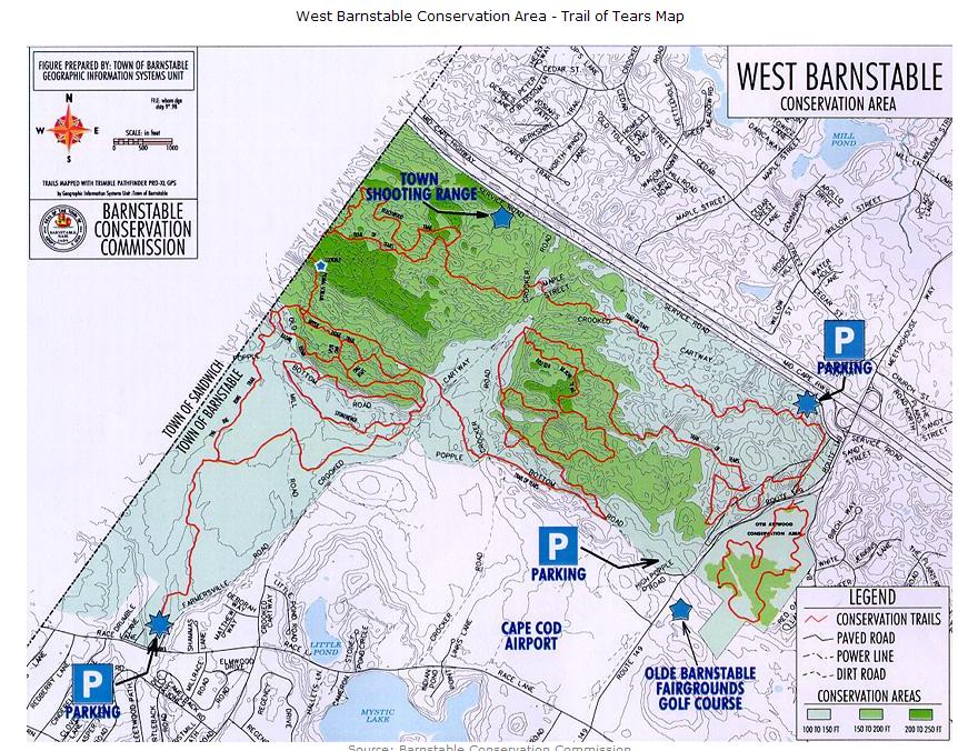
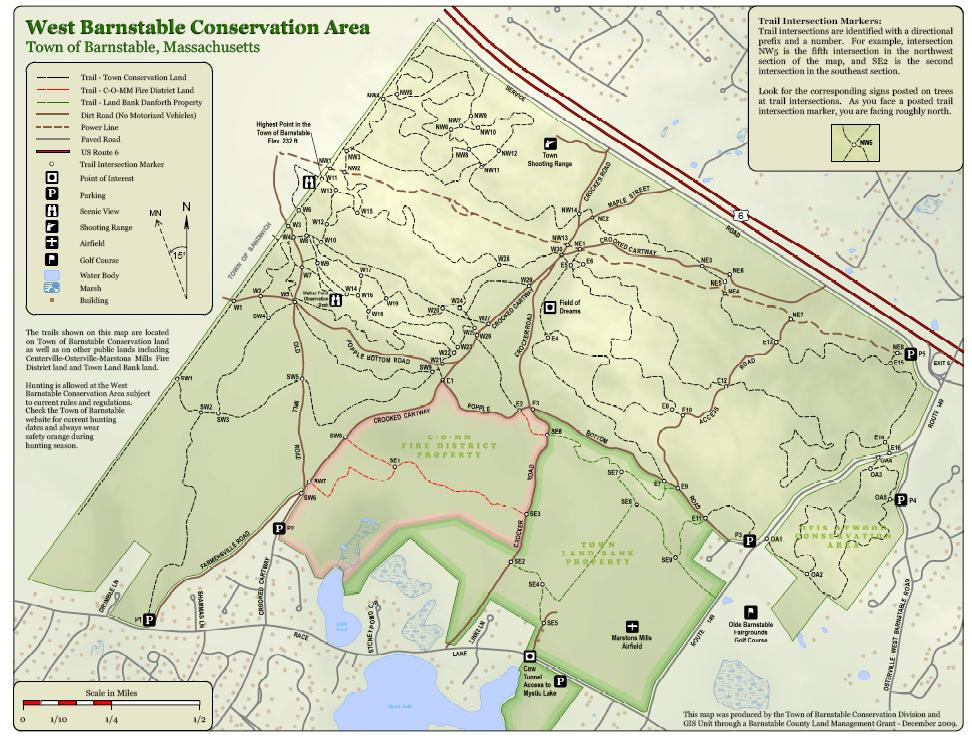
21 West Barnstable Conservation Area - Trail of Tears Overview: The Trail of Tears is one of the most popular riding spots on Cape Cod. Located within the West Barnstable Conservation area, it is a 15-mile network of twisty rolling singletrack, complete with big ring downhills and short, technical climbs. One of these trails' most amazing attributes is the variety of terrain one can encounter in any given ride. From loamy singletrack with pine needles and roots to hardpack rock gardens and deep soft sand, there's always something to surprise and challenge you around every turn... Parking & Directions: Three trailhead parking areas provide easy access to the network. the largest being the Service Rd. entrance located off Rt. 149 just south of Route 6 (pictured left). Take the Service Road and drive about 1/10 of a mile - the trailhead is located on the left under the powerlines. The second lot is at Farmersville Rd. off Race Lane. Take Rt. 149 to Race Ln. and head west. After about 1 1/2 miles, look for the parking area on the right. The third area is on Popple Bottom Road, just north of the Olde Barnstable Fairgrounds Golf Course. Take Popple Bottom Rd. off Rt. 149 and look for the entrance on your right. Area Details: Comprising 1,114 acres, the West Barnstable Conservation Area is Barnstable's largest dedicated conservation tract. As previously mentioned, these trails offer various types of terrain, both smooth, technical and in-between. The forest is a mixture of pine and oak, along with small amounts of fir and other tree species. This network follows the Barnstable powerlines down to the Sandwich border at Chase Rd. Doubletrack and fire roads also crisscross the entire parcel, providing even more riding opportunities. Be aware that hunting is allowed within the area in-season. A Town-operated shooting range is also in close proximity, and gunfire is not an uncommon ride soundtrack. When at the Service Rd. entrance, follow the powerlines for about 30 yds. until you see a small trail angling off the left (pictured right). This will take you into the beginning of the network on the Rt. 149 side. The trail will then fork - the right trail is more smooth and rolling with loam/pine needle-type singletrack. The left will take you on a much more technical, hardpack route. Keep in mind that both trails are very twisty, with s-curves and short, steep climbs. From either of these you can go in any number of directions on outlets and completely different trails. Have fun but remember to respect the rights of others - horseback riders and hikers also frequent this network often.
22


23 Shining Sea Bikeway Overview: Parking & Directions: Area Details: The Shining Sea Bikeway was named for the line in the song America The Beautiful, written by Falmouth native Katharine Lee Bates. It follows the original route of the New York, New Haven and Hartford Railroad that used to run from Buzzards Bay, through North and West Falmouth, around Woods Hole and into Falmouth Station. In the early 1970's the Town of Falmouth purchased the right of way, tore up the tracks and officially opened the Bikeway in To reach the Shining Sea Bikeway, take Rt. 24 south to south to the Bourne Bridge. From points north, take Rt. 3 south to the Sagamore Bridge rotary. Follow the signs to Buzzards Bay/Falmouth, then cross over the Bourne Bridge. From Bourne Bridge: travel Rt. 28 south to Falmouth. Fork right onto Locust Road. Entry to the bikeway parking area is a mile down on the right just past Pin Oak Way. The Shining Sea Bikeway follows the coast from Falmouth to Woods Hole, winding along the Vineyard Sound shoreline. Ideal for casual and beginner cyclists, it was built on a former railroad right-of-way, and is level nearly the entire 3.3-mile distance. Lined with familiar Cape Cod flower and tree species, it makes for a wonderful ride from Falmouth to scenic Woods Hole.This route avoids much of Falmouth's notorious summer traffic by winding down along the beach, through marshes and through the Salt Pond Bird Sanctuary. This is a frequently used area in-season, so be sure to respect the rights of others, especially inline skaters and runners.

24
2.8 SUB-REGIONAL ISSUES
 2.8 SUB-REGIONAL ISSUES Each town, village, business district, and even each neighborhood will have a slightly different (and in a handful of cases a drastically different) set of options and conditions
FFY Development. Transportation Improvement Program (TIP) March 11, 2016 Cape Cod Joint Transportation Committee
 March 11, 2016 Cape Cod Joint Transportation Committee") FFY 2017-2021 Transportation Improvement Program (TIP) Development March 11, 2016 Cape Cod Joint Transportation Committee Transportation Improvement Program (TIP) + The TIP is a five-year schedule of regional
FFY 2017-2021 Transportation Improvement Program (TIP) Development March 11, 2016 Cape Cod Joint Transportation Committee Transportation Improvement Program (TIP) + The TIP is a five-year schedule of regional
the cape cod bike pdf Cape Cod Canal: Paved Bike Path Cape Cod Bike Guide Cape Cod Rail Trail: Paved Bike Path Cape Cod Bike Guide
 DOWNLOAD OR READ : THE CAPE COD BIKE BOOK A COMPLETE GUIDE TO THE BIKE TRAILS OF CAPE COD CAPE COD RAIL TRAIL NICKERSON PARK TRAILS FALMOUTH WOODS HOLE TRAIL NATIONAL SEASHORE TRAILS PDF EBOOK EPUB MOBI
A Publication of Friends of Sleeping Bear Dunes
 A Publication of Friends of Sleeping Bear Dunes 2014, Friends of Sleeping Bear Dunes, P.O. Box 545, Empire, MI 49630 www.friendsofsleepingbear.org info@friendsofsleepingbear.org Learn more about the Friends
Non-motorized Trail Plan & Proposal. August 8, 2014
 Town of Star Valley Ranch, Wyoming and the Star Valley Ranch Association in partnership with the USDA Forest Service, Bridger-Teton National Forest, Greys River Ranger District Non-motorized Trail Plan
Crystal Lake Area Trails
 Lake Area Trails Welcome to the Lake area of the Big Snowy Mountains! This island mountain range in central Montana features peaks reaching to 8,600 feet and long, high ridges from which vistas of the
The gorges of Mohican Park in Ohio create a hiker's paradise Sunday, May 22, 2011 By Bob Downing, Akron Beacon Journal
 Pittsburgh Post-Gazette The gorges of Mohican Park in Ohio create a hiker's paradise Sunday, May 22, 2011 By Bob Downing, Akron Beacon Journal Bob Downing Big Lyons Falls drops 80 feet into a shady U-shaped
FLEX - Harwich to Provincetown WINTER/SPRING 2018
 CAPE COD'S PUBLIC TRANSIT SYSTEM FLEX - Harwich to Provincetown WINTER/SPRING 2018 January 27, 2018 through June 22, 2018 Hyannis Transportation Center Pick-up/drop-off area located at Main and Center
Section 7: Pick Up Where You Left Off! S-Tree Road over the Todd Road
 2018 TRACE NOTES Helpful information for your adventure on Section 7 of the Hiker Challenge. Start Point S-Tree Rd. End Point Intersection Todd Rd. / Hale Ridge Rd. WEATHER DECISION Weather Alert!!!! Potential
GOLDEN EARS PROVINCIAL PARK
 GOLDEN EARS PROVINCIAL PARK Trail Information as of October 10 th 2015 Do not underestimate the mountainous wilderness of Golden Ears Provincial Park. The combination of rugged terrain and rapidly changing
Provincetown - North Truro Shuttle FALL/WINTER
 CAPE COD'S PUBLIC TRANSIT SYSTEM Provincetown - North Truro Shuttle FALL/WINTER 2018 2019 September 4, 2018 through January 25, 2019 Hyannis Transportation Center Pick-up/drop-off area located at Main
Provicetown - North Truro Shuttle SUMMER 2018
 CAPE COD'S PUBLIC TRANSIT SYSTEM Provicetown - North Truro Shuttle SUMMER 2018 June 23, 2018 through September 3, 2018 Hyannis Transportation Center Pick-up/drop-off area located at Main and Center Street.
What are you getting into?
 Overnight Camping What are you getting into? You will be hiking with your gear to a campground about ½ mile away and spending 1 night camping You will help to prepare a meal over an open flame You will
Difficult Run Stream Valley Park
 Difficult Run Stream Valley Park The more intense mountain bikers have known about for Difficult Run for some time. Equestrians have known it longer. Eight miles of unpaved trail, the Rails to River Trail
Black Hill Regional Park, Little Seneca Lake
 Black Hill Regional Park, ittle Seneca ake ittle Seneca ake, in Black Hill Regional Park, is a reservoir created after a previous drought struck the Washington area. The park is under Maryland-National
Stephens State Park Trails
 TRAILS OF ALLAMUCHY MOUNTAIN & STEPHENS STATE PARKS Allamuchy Mountain and Stephens State Parks contain 28 marked trails providing access to diverse landscapes for walking, hiking, biking, bird-watching,
HIKING/BIKING IN MERRITT AREA
 HIKING/BIKING IN MERRITT AREA Coquihalla Lakes: Just inside the southern boundary of BC Park's Coquihalla Summit Park, a nice little twin lakes paddle with a private campground & lodge is the Coquihalla
Other Agencies and Organizations
 Daniel Boone National Forest 1700 Bypass Road WInchester, KY 40391 859-745-3100 Location Northern terminus is near Morehead, Kentucky. Southern terminus is located in the Big South Fork NRRA in Tennessee.
Santa Clara South Hills Recreation Park Project Development and Management Plan
 Santa Clara South Hills Recreation Park Project Application for Land for Recreation or Public Purposes, City of Santa Clara, Utah Prepared for: Bureau of Land Management, St. George Field Office 345 East
Subj: POLICY FOR MAINSIDE TRAIL USE AT MARINE CORPS BASE QUANTICO
 UNITED STATES MARINE CORPS MARINE CORPS BASE QUANTICO, VIRGINIA 22134-5001 MCBO 5090.4 B 04 MARINE CORPS BASE ORDER 5090.4 From: Commander To: Distribution List Subj: POLICY FOR MAINSIDE TRAIL USE AT MARINE
Procedure for the Use of Power-Driven Mobility Devices on Mass Audubon Sanctuaries 1 September 17, 2012
 Procedure for the Use of Power-Driven Mobility Devices on Mass Audubon Sanctuaries 1 September 17, 2012 Background As part of Mass Audubon s mission to preserve the nature of Massachusetts for people and
SOL VS.2a, 2b, 2c, 10b
 What are the characteristics of the Coastal Plain? 1. Also known as Tidewater 2. Located near the Atlantic Ocean and the Chesapeake Bay 3. Includes the Eastern Shore, a peninsula between the Atlantic Ocean
Telluride-to-Moab Alternative Singletrack Options
 Telluride-to-Moab Alternative Singletrack Options Day 1 Day 1 Alternate 1: Galloping Goose to Deep Creek. 18.4 miles, ascent 3,530ft, descent 1,388ft. This is fun, flowey, moderate to intermediate singletrack
SDTrucksprings. Arkansas Off-roading/4x4 Guide Copyright 2015 We Specialize In:
 SDTrucksprings Arkansas Off-roading/4x4 Guide Copyright 2015 We Specialize In: Helper Springs Air Bags Leaf Springs Body Lift Kits Coil Springs Timbren Kits Hellwig Springs Lift Blocks And More! Visit
BRYCE CANYON COUNTRY Boulder Mountain Scenic backways itinerary
 BRYCE CANYON COUNTRY Boulder Mountain Scenic backways itinerary Boulder Mountain Area The high plateaus of the Aquarius Plateau (Boulder Mountain), are heavily forested and covered in countless winding
MASTER PLAN EXECUTIVE SUMMARY
 Biscuit Run State Park Scottsville Road (State Route 20) Charlottesville, VA 22902 Biscuit Run State Park MASTER PLAN EXECUTIVE SUMMARY Department of Conservation and Recreation Division of Planning and
San Luis Obispo. Bishop Peak Felsman Loop Eagle Rock Maino Open Space Poly Canyon Poly P Other Areas
 San Luis Obispo Bishop Peak Felsman Loop Eagle Rock Maino Open Space Poly Canyon Poly P Other Areas 1 JCT. ELEV. 72 400 00 0 FELSMAN LOOP GATE LOOP RIDGE 600 FENCE JCT. ELEV. 860 1000 1200 BISHOP PEAK
PROJECT REPORT Alaska Volunteer Trip Juneau Ranger District, Tongass National Forest and Klondike Gold Rush National Historical Park June 12-22, 2017
 PROJECT REPORT Alaska Volunteer Trip Juneau Ranger District, Tongass National Forest and Klondike Gold Rush National Historical Park June 12-22, 2017 SUMMARY Sixteen Conservation Volunteers International
Table of Contents. page 3 Long term Goals Project Scope Project History. 4 User Groups Defined Trail Representative Committee. 5 Trail Users Breakdown
 Launched April 27th, 2010 1 Table of Contents page 3 Long term Goals Project Scope Project History 4 User Groups Defined Trail Representative Committee 5 Trail Users Breakdown 13 Trail Users Desires 16
The Bourne Run WINTER/SPRING 2019
 CAPE COD'S PUBLIC TRANSIT SYSTEM The Bourne Run WINTER/SPRING 2019 January 26, 2019 through June 21, 2019 Hyannis Transportation Center Pick-up/drop-off area located at Main and Center Street. Parking
Appendix 3. Greenway Design Standards. The Whitemarsh Township Greenway Plan
 Appendix 3 Greenway Design Standards This chapter discusses two design standards for the greenway types discussed above. First, trail design standards are presented together with trailhead facilities and
A CASE FOR COMPLETING THE JORDAN RIVER PARKWAY: A
 A CASE FOR COMPLETING THE JORDAN RIVER PARKWAY: A safe crossing at 9000 South and 850 West Proposed 9000 South Underpass Parkway Timeline Parkway, Trail, and Tourism Facts Blueprint Jordan River 1971 1973
Segment 2: La Crescent to Miller s Corner
 goal of the USFWS refuges is to conserve, protect and enhance fish, wildlife and plants and their habitats for the continuing benefit of the American people. Refuge lands are used largely for fishing,
Understanding user expectations And planning for long term sustainability 1
 Understanding user expectations And planning for long term sustainability 1 What is a natural surface trail? It can be as simple has a mineral soil, mulched or graveled pathway, or as developed as elevated
Piestewa Peak/Dreamy Draw Trail Guide
 Piestewa Peak/Dreamy Draw Trail Guide Trail #1A - Perl Charles Memorial Trail Length: 4.8 miles Elevation: 2,200 ft. - 1,340 ft. Difficulty: Moderate to difficult The Perl Charles trailhead is located
MORGAN CREEK GREENWAY Final Report APPENDICES
 APPENDICES MORGAN CREEK GREENWAY Appendix A Photos of Existing Conditions in Trail Corridor Photos of existing conditions Main trail corridor - February 2009 Photos of existing conditions south bank Morgan
Lake Wissota Access Locations within the LaFayette Township. By Chad Martin
 Lake Wissota Access Locations within the LaFayette Township By Chad Martin Anson/ Wissota Access Point # 1 Road: 195 th St. Associated Fire Numbers: 13294 Defining Characteristics: Forested from road
SDTrucksprings. Indiana Off-roading/4x4 Guide Copyright 2015 We Specialize In:
 SDTrucksprings Indiana Off-roading/4x4 Guide Copyright 2015 We Specialize In: Helper Springs Air Bags Leaf Springs Body Lift Kits Coil Springs Timbren Kits Hellwig Springs Lift Blocks And More! Visit www.sdtrucksprings.com
The Sandwich Line SUMMER 2018
 CAPE COD'S PUBLIC TRANSIT SYSTEM The Sandwich Line SUMMER 2018 June 23, 2018 through September 3, 2018 Hyannis Transportation Center Pick-up/drop-off area located at Main and Center Street. CCRTA Hyannis
BRACEVILLE NATURE PRESERVE Introductions History Present Conditions Future Development Plans Implementation Strategies Statistics
 BRACEVILLE NATURE PRESERVE Introductions History Present Conditions Future Development Plans Implementation Strategies Statistics Introduction Braceville Nature Preserve is one of MetroParks largest preserves.
Region 1 Piney Woods
 Region 1 Piney Woods Piney Woods 1. This ecoregion is found in East Texas. 2. Climate: average annual rainfall of 36 to 50 inches is fairly uniformly distributed throughout the year, and humidity and temperatures
KETTLE CREEK CONSERVATION AUTHORITY TRAIL GUIDE.
 KETTLE CREEK CONSERVATION AUTHORITY TRAIL GUIDE www.kettlecreekconservation.on.ca EXPLORE OUR TRAILS HIKE OUR TRAILS Kettle Creek Conservation Authority (KCCA) proudly supports and promotes an active lifestyle
SAXON HARBOR REDEVELOPMENT SURVEY
 SAXON HARBOR REDEVELOPMENT SURVEY SEPTEMBER, 2016 1,173 RESPONSES 1 BACKGROUND 1. WHAT TYPES OF ACTIVITIES DO YOU ENGAGE IN AT SAXON HARBOR Sightseeing Swimming Picnicing Fishing Camping Photography Motorized
Griffith Park Trail Run Trail Guide Click for
 The Griffith Park Trail Run by Hike- LosAngeles.com Griffith Park Trail Run Trail Guide Click for downloadable cell phone guide and map from EveryTrail. DISTANCE: 4.55 Miles ELEVATION: 1280' ELEVATION
TART Trails, Inc. (231)
") TART Trail System TART Trails, Inc. www.traversetrails.org (231) 941-4300 Leelanau Trail Stretching 15 miles along a former railroad corridor, the TART-owned Leelanau Trail connects Traverse City and Suttons
TART Trail System TART Trails, Inc. www.traversetrails.org (231) 941-4300 Leelanau Trail Stretching 15 miles along a former railroad corridor, the TART-owned Leelanau Trail connects Traverse City and Suttons
Rogue Gorge (Mt. Stella) Roadless Area-- T30S R3E (primarily in portions of Sections 23, 26, 33, 34 & 35)
 Roadless Area-- T30S R3E (primarily in portions of Sections 23, 26, 33, 34 & 35)") Rogue Gorge (Mt. Stella) Roadless Area-- T30S R3E (primarily in portions of Sections 23, 26, 33, 34 & 35) Rogue River-Siskiyou National Forest--High Cascades Ranger District Upper, higher elevation trail
Rogue Gorge (Mt. Stella) Roadless Area-- T30S R3E (primarily in portions of Sections 23, 26, 33, 34 & 35) Rogue River-Siskiyou National Forest--High Cascades Ranger District Upper, higher elevation trail
Tiger Mountain State Forest:
 98 60 hikes within 60 miles: SEATTLE 20 Tiger Mountain State Forest: West Tiger Mountain Three Loop i KEY AT-A-GLANCE INFORMATION Length: 5.1 miles round-trip Configuration: Loop Difficulty: Moderate difficult
Hyannis to Orleans FALL/WINTER
 CAPE COD'S PUBLIC TRANSIT SYSTEM Hyannis to Orleans FALL/WINTER 2018 2019 September 4, 2018 through January 25, 2019 Hyannis Transportation Center Pick-up/drop-off area located at Main and Center Street.
The Croatan MST Segment 16B
 1 Mountains-to-Sea Trail Last Updated 1/1/2017 A sandy road through longleaf pine savanna in the Croatan National Forest Photo by PJ Wetzel, www.pjwetzel.com The Croatan MST Segment 16B STELLA TO THE NEUSIOK
throu Booth Hill Green Belt
 s k r a p s l l u b m u r T Explore gh Geocaching throu Booth Hill Green Belt This was originally a concept to try and preserve some of the land in our town, without hurting the developers that are creating
THOMAS A. SWIFT METROPARK Introductions History Present Conditions Future Development Plans Implementation Strategies Statistics
 THOMAS A. SWIFT METROPARK Introductions History Present Conditions Future Development Plans Implementation Strategies Statistics Introduction As an open meadow park positioned along the Mahoning River,
WATER PETALUMA TRAIL WATER WAYS PROJECT PORTFOLIO. petalumawaterways.org OVERVIEW
 WATER TRAIL PROJECT PORTFOLIO OVERVIEW Thirteen miles upstream of San Pablo Bay, Petaluma is the northern point on the San Francisco Bay Water Trail, a network of access points throughout the region. Most
Hazlet. 1. Overview of Hazlet and Its Waterfront. Hazlet Township. 1.1 Geographic Overview
 Hazlet 1. Overview of Hazlet and Its Waterfront 1.1 Geographic Overview Hazlet Township is located in Monmouth County. The Township has a land area of 5.6 square miles. Situated in the Bayshore region
Beaver Creek State Park
 GENERAL INFORMATION Name of Park/Forest/Facility: Beaver Creek State Park County: Columbiana (St. Clair Township) Address: 12816 Sprucevale Road (ie County Rd 428) (street #, city) East Liverpool, Ohio
2019 DAY HIKE AT IRON MOUNTAIN SATURDAY, JANUARY 19
 WHERE? In Google Maps, paste the following coordinates for Iron Mountain: 32.978215,-116.972593 or CLICK ON THIS LINK. I. Purpose of the Day Hike A. THE WBC Day Hike is a relatively short trail hike to
Note: Coordinates are provided as Universal Transverse Mercator UTM Zone U21, North American Datum 1983 (NAD 83).
.") Northern Traverse Route Description The Northern Traverse (formerly the North Rim Traverse) is an unmarked and rugged backcountry hiking route. It is known be a demanding hike, because of its terrain and
Northern Traverse Route Description The Northern Traverse (formerly the North Rim Traverse) is an unmarked and rugged backcountry hiking route. It is known be a demanding hike, because of its terrain and
VOLUME II APPENDIX F DETAILED PHYSICAL DESCRIPTION OF PROJECT RESERVOIRS AND LANDS
 VOLUME II APPENDIX F DETAILED PHYSICAL DESCRIPTION OF PROJECT RESERVOIRS AND LANDS THE CENTRAL NEBRASKA PUBLIC POWER AND IRRIGATION DISTRICT FERC PROJECT NO. 1417 PHYSICAL DESCRIPTION OF PROJECT LANDS
FEASIBILITY CRITERIA
 This chapter describes the methodology and criteria used to evaluate the feasibility of developing trails throughout the study areas. Land availability, habitat sensitivity, roadway crossings and on-street
Miner & Silverstein Appraisal Company Division of Miner & Silverstein, LLP
 Miner & Silverstein Appraisal Company Division of Miner & Silverstein, LLP Marina Market Analysis Upper Connecticut River Marina Market Study Winter 2005-2006 The following presents a winter 2005-06 market
ASRA 2018 Hike Schedule
 ASRA 2018 Hike Schedule Date/Day Destination Hike Info Meeting Info Leader Feb 10, Saturday Stagecoach and 9:00 at the Confluence kiosk. Manzanita trails Parking fee required. We ll hike along the trail
Greater Minnesota Regional Parks and Trails Commission Designation Application
 Greater Minnesota Regional Parks and Trails Commission Designation Application General Section Designation Application #: 15-059D Date Submitted: 06/16/2015 Park or Trail Name: Mesabi Trail District #:
TRAILS WHERE TO FIND TRAILS IN NOVA SCOTIA
 TRAILs SIGNAGE Know the Signs............................ 44 WHERE YOU CAN RIDE Roads and Highways........................ 46 Designated Trails........................... 47 Established Trails...........................
Hyannis to Orleans SUMMER 2018
 CAPE COD'S PUBLIC TRANSIT SYSTEM Hyannis to Orleans SUMMER 2018 June 23, 2018 through September 3, 2018 Hyannis Transportation Center Pick-up/drop-off area located at Main and Center Street. CCRTA Hyannis
SDTrucksprings. Massachusetts Off-roading/4x4 Guide Copyright 2015 We Specialize In:
 SDTrucksprings Massachusetts Off-roading/4x4 Guide Copyright 2015 We Specialize In: Helper Springs Air Bags Leaf Springs Body Lift Kits Coil Springs Timbren Kits Hellwig Springs Lift Blocks And More! Visit
APPENDIX D: SUSTAINABLE TRAIL DESIGN. APPENDICES Town of Chili Parks and Recreation Master Plan Update
 APPENDIX D: SUSTAINABLE TRAIL DESIGN APPENDICES Town of Chili Parks and Recreation Master Plan Update Sustainable Trail Construction Sustainable trails are defined by the US Forest Service as trails having
Skiing and Snowshoes on Un-groomed Fernan Saddle Terrain
 Skiing and Snowshoes on Un-groomed Fernan Saddle Terrain Three ski or snowshoe routes are available from the Fernan Saddle Parking Lot which either do not cover routes ordinarily groomed for snow machine
Trail Beginning Elevation: 7553 ft The Poison Creek Trailhead is located at the end of National Forest Road 646E (NF-646E).
.") West Mountain Trails Poison Creek Trail #134 Length: 2.9 miles (4.7 km) Difficulty Horseback: A good trail for the first time west mountain rider, some steep sections Hiking: Most Difficult USGS Maps:
West Mountain Trails Poison Creek Trail #134 Length: 2.9 miles (4.7 km) Difficulty Horseback: A good trail for the first time west mountain rider, some steep sections Hiking: Most Difficult USGS Maps:
CHAPTER 5. Chapter 5 Recreation Element
 CHAPTER 5 Recreation Element Chapter 5 Recreation Element The Recreation Element of the Meyers Area Plan is a supplement to the Recreation Element of the TRPA Regional Plan and the El Dorado County General
The 50th Anniversary Challenge
 Friends Of The Cape Cod National Seashore Presents The 50th Anniversary Challenge Highland Light Bike Trails Old Harbor Station Atwood- Higgins House Doane Rock Salt Pond Atlantic White Cedar Swamp Trail
Trail Etiquette. Hours of Operation. Trail Accessibility
 Trail Guide The Elmhurst Park District, with 28 parks and over 460 acres of land, offers nearly six miles of paved or asphalt park trails and maintains an additional 3.6 miles of trails within Elmhurst.
National Recreation Trail Update Form
 National Recreation Trail Update Form Introduction Thank you for taking the time to complete this form. Your assistance will help ensure that the National Recreation Trail (NRT) database is complete and
CIEC 9 PEAKS AWARD SUPPLEMENT POSSIBLE ROUTES FOR THE 9 PEAKS AWARD TRIP
 CIEC 9 PEAKS AWARD SUPPLEMENT POSSIBLE ROUTES FOR THE 9 PEAKS AWARD TRIP As you plan your trip, be aware of 3 regulations in this wilderness: 1. Camp only in designated campsites. 2. No campfires allowed.
F.O.K.O.S. Friends of Kingston Open Space A GUIDE TO KINGSTON OPEN SPACE
 F.O.K.O.S. Friends of Kingston Open Space A GUIDE TO KINGSTON OPEN SPACE Friends of Kingston Open Space (FOKOS) was formed when a handful of concerned citizens joined together to learn what could be done
CARVER S FALLS. Cumberland County s Natural Beauty. What s Included In This Information Packette
 Cumberland County s Natural Beauty What s Included In This Information Packette History of the Falls Boy Scouts have acquired Right of Use Guidelines for Usage Application Check-out Report HISTORY AND
Hyannis Loop FALL/WINTER
 CAPE COD'S PUBLIC TRANSIT SYSTEM Hyannis Loop FALL/WINTER 2018 2019 September 4, 2018 through January 25, 2019 Hyannis Transportation Center Pick-up/drop-off area located at Main and Center Street. CCRTA
Marilla Reservoir to Chestnut Ridge via Marilla Trails and Bullis Hollow Trail east to west
 USGS topographic maps useful to this hike are the Bradford and Stickney 7.5 minute sectionals. These notes are designed to assist in identifying distance and location using geophysical and man-made characteristics
Nov. 19 th Public Workshop Summary
 On November 19 th, more than 60 community members attended an Open Space Matters workshop at the Linen Building in downtown Boise for over two hours. Participants learned about reserves, discussed the
Photographing Upper Peninsula Waterfalls
 Photographing Upper Peninsula Waterfalls Tod Poirier Freelance Photographer Photography is one of my passions. The following spread showcases several Upper Peninsula waterfalls. At times a single drop
National Recreation Trail Application for Designation
 National Recreation Trail Application for Designation Introduction Thank you for your interest in the National Recreation Trail (NRT) program. Completed NRT application packages must be submitted by December
Kostenlose Ebooks Biking Ohio's Rail Trails
 Kostenlose Ebooks Biking Ohio's Rail Trails An indispensable book for bikers, hikers, walkers, joggers and families who want to enjoy Ohio's trails. --This text refers to an out of print or unavailable
What Is An Ecoregion?
 Ecoregions of Texas What Is An Ecoregion? Ecoregion a major ecosystem with distinctive geography, characteristic plants and animals, and ecosystems that receives uniform solar radiation and moisture Sometimes
HARBOR INFRASTRUCTURE INVENTORIES Buffalo Harbor, New York
 HARBOR INFRASTRUCTURE INVENTORIES Buffalo Harbor, New York Harbor Location: Buffalo Harbor is located on the Eastern shore of Lake Erie in the City of Buffalo, NY. Authority: River & Harbor Acts of 1826,
C E N T R A L C A T S K I L L S
 120 C E N T R A L C A T S K I L L S Central Catskills Once out of the southern parts of the Catskills, the Long Path enters the more well traveled and civilized regions. The trail joins the Devil s Path,
Location: Height: Access: Distance: Elevation: Season: Difficulty: Lat/Long: Directions:
 Upper Eagle Falls Upper Eagle Falls (~20 ft.) is a short hike up from the roadside at the Eagle Falls picnic area. It is very difficult to get a parking spot here during the day, so it is recommended to
Blueways: Rivers, lakes, or streams with public access for recreation that includes fishing, nature observation, and opportunities for boating.
 Parks, Open Space and Trails PRINCE WILLIAM COUNTY 2008 COMPREHENSIVE PLAN TRAILS PLAN CONTENTS The components of the trails plan are: Intent Definitions Goals, Policies, and Action Strategies Trails Map
Group similar facilities together separate dissimilar facilities.
 Park design Principle #1 Group similar facilities together separate dissimilar facilities. Why do we do this? Safety Differences in admission fees Differences in seasonal use Reduce user conflicts Principle
System Group Meeting #1. March 2014
 System Group Meeting #1 March 2014 Meeting #1 Outcomes 1. Understand Your Role 2. List of Revisions to Existing Conditions 3. Information Sources Study Area The Purpose of Mountain Accord is to Preserve
beach. Make the ford and follow the trail out to the junction with Red Creek Tr in an open grassy area.
 Description: This is a moderate to slightly strenuous 22.8 mile backpack (add 2.6 miles if you do the packless out and back to the Lion s Head) that will have you exploring nearly every thing that is The
1 2 O N T H E B A S I N
 12 ON THE BASIN ½ PAST EIGHT Shrub-ridden coastlines and a family of mallard ducks. Wind-struck entanglements. A passage of air leads east. How do I get from the other side? Two shoes submerged in mud,
Final Recreation Report. Sunflower Allotment Grazing Analysis. July 2015
 Final Recreation Report Sunflower Allotment Grazing Analysis July 2015 Table of Contents Introduction... 3 Affected Environment... 3 Four Peaks Wilderness Area... 3 Dispersed Recreation... 3 Environmental
THE RESERVE III AT SUGAR MOUNTAIN, NORTH CAROLINA
 THE RESERVE III AT SUGAR MOUNTAIN, NORTH CAROLINA Information Memorandum AUGUST 2015 THE RESERVE III Contents I. THE PROPERTY... 3 OVERVIEW... 3 READY TO BUILD... 4 INEXPENSIVE CONSTRUCTION... 5 ADDITIONAL
Lava Mountain Trail Distance: Elevation Range: Trail Type: Difficulty: Season: Driving Distance: Driving Time: USGS Maps: Pros Cons
 Lava Mountain Trail Distance: 13.4 miles (including the side trip to North Star Lake) Elevation Range: 5900'-8330' Trail Type: singletrack Difficulty: moderate Season: late June-October Driving Distance:
AGENDA ITEM 5 D WAKULLA ENVIRONMENTAL INSTITUTE (WEI) TRAIL FEASIBILITY STUDY
 TRAIL FEASIBILITY STUDY") March 19, 2018 AGENDA ITEM 5 D WAKULLA ENVIRONMENTAL INSTITUTE (WEI) TRAIL FEASIBILITY STUDY TYPE OF ITEM: Action STATEMENT OF ISSUE The Wakulla Environmental Institute (WEI) Trail is one of several trails
March 19, 2018 AGENDA ITEM 5 D WAKULLA ENVIRONMENTAL INSTITUTE (WEI) TRAIL FEASIBILITY STUDY TYPE OF ITEM: Action STATEMENT OF ISSUE The Wakulla Environmental Institute (WEI) Trail is one of several trails
Day 1 History & Wildlife
 Welcome to our 3 Day Newberry, MI Itinerary brought to you by America s Best Value Inn Tahquamenon Country of Newberry. Day 1 History & Wildlife The Luce County Historical Museum Drive time: 5 minutes
ENVIRONMENTAL SYSTEMS LESSONS High School level DRAFT
 ENVIRONMENTAL SYSTEMS LESSONS High School level DRAFT Project: Data Sets and Inquiry in Geoscience Environmental Restoration Studies (NSF GEO- 0808076) Authors: Daniel Zalles, Center for Technology in
Bankhead Lake TWO PARCELS AND 1 LOT FOR SALE
 OVERVIEW NORTH PARCEL ACRES: 46 WATERFRONT: 1,227 Front Feet PRICE: $350,000 PER ACRE: $7574 PER FRONT FT. $285 SOUTH PARCEL ACRES: 22 WATERFRONT: 1,381 Front Feet PRICE: $295,000 PER ACRE: $13,170 PER
Supplemental No. 8 AGENDA ITEM #6.B Distributed 9/19/17
 Supplemental No. 8 AGENDA ITEM #6.B Distributed 9/19/17 18 Sept, 2017 To: Los Altos Hills Mayor Waldeck and Members of the Los Altos Hills City Council Re: 27333 Ursula Lane request for pathway removal
West Orange Trail. Clean, Green, Fun!
 West Orange Trail Clean, Green, Fun! The West Orange Trail - when completed - will be a 36-mile, multipurpose recreational greenway containing a 14-foot wide paved surface to be enjoyed by walkers, joggers,
13.1 REGIONAL TOURISM ISSUES AND SUMMARY OF FINDINGS
 13 REGIONAL TOURISM T he County of Mariposa s recreation needs and facilities fall within two categories: regional tourism and local recreation. This Element focuses on regional tourism issues related
MPRB: Southwest LRT Community Advisory Committee Issues and Outcomes by Location Current to: 12 November 2010
 MPRB: Southwest LRT Community Advisory Committee Issues and Outcomes by Location Current to: 12 November 2010 This is a compilation of issues and outcomes identified by the CAC. It is a work in progress,