HIGH LINE CANAL PRESERVATION AND ENHANCEMENT PLANNING STUDY SECTION NO.7 SIGNAGE IMPROVEMENT AND STANDARDIZATION ANALYSIS
|
|
|
- Stephanie Strickland
- 5 years ago
- Views:
Transcription
1 HIGH LINE CANAL PRESERVATION AND ENHANCEMENT PLANNING STUDY SECTION NO.7 SIGNAGE IMPROVEMENT AND STANDARDIZATION ANALYSIS
2 HIGH LINE CANAL PRESERVATION AND ENHANCEMENT PLANNING STUDY SECTION NO.7 SIGNAGE IMPROVEMENT AND STANDARDIZATION ANALYSIS INTRODUCTION: August 21, 2012 Objective: The High Line Canal signage improvement and standardization analysis was undertaken to evaluate the way-finding information available to trail users along the study corridor, and to identify ways to improve the information presented. This discussion necessarily begins with an exceptional and unique aspect of the High Line Canal, that being its very size. As it meanders along the contours from the southwest boundary to the northeast limit of the Denver metropolitan area, it passes through four counties and seven cities, all of which have individual design standards for trail signage, and all of which are interested in establishing and promoting their individual brands. As a consequence of this multi-jurisdictional fabric, with numerous agencies investing in and responsible for the maintenance of the canal trail through their own communities, we see a segmented and provincial approach to signage along the canal. Contributing to this segmented and provincial approach is the fact that Denver Water has taken a passive approach to signage along the canal, not developing or setting forth any standards that would bring all of the canal signage under the umbrella of one agency. As a consequence, virtually none of the signage along the canal trail recognizes the contribution of Denver Water in making its maintenance access road available to trail users for their pleasure and use. Finally and most significantly, in a glaring omission, none of the signage along the High Line Canal trail is specific to the High Line Canal. None of the signage shows the entire length of the system, and nowhere is its rich and important historical legacy recognized or celebrated. Considerations: All of the municipalities that have placed signage on the canal have developed, adopted and codified standards for signage. All of the signage standards promote the municipal brand of the respective community, in an effort to communicate to constituents the maintenance contribution that each municipality makes to the High Line Canal trail, which is a perfectly legitimate endeavor. We are here to advocate for the canal, and with the understanding that the High Line Canal is different from the High Line Canal trail, we are recommending that in the short term two series of signs be developed and installed specifically for the High Line Canal. 1) The first series of signs for development and installment are trail signs that show the local quadrant of the canal with detailed way-finding information and a system-wide inset showing the entire High Line Canal system, as well as rules and regulations information. 2) The second series of signs for development and installment are interpretative signs that recognize and celebrate the rich and important historical contribution of the High Line Canal to all of the communities along its course. This new High Line Canal-specific signage should be mounted on custom standards that begin to develop a High Line Canal-specific brand as part of a larger canal-specific family of design elements. In the long term, a set of signage guidelines needs to be developed in cooperation with Denver Water and the municipalities responsible for trail maintenance. Supporting Documentation: For a detailed analysis and discussion of the signage improvement and standardization analysis, please see: High Line Canal signage inventory report pages No.1 through No.2. High Line Canal signage inventory plan sheets No.S1 through No.S5. High Line Canal signage improvement report pages No.1 through No.2. High Line Canal sample trail sign. High Line Canal sample interpretative sign. Transit system signage concept sheet. Signage is expensive to design, fabricate and install. In an effort to manage costs, and take advantage of economies of scale, in the design, fabrication/reproduction, and installation of signage, individual signs are produced from standard templates adopted by each municipality. Developing and adopting new signage templates is a considerable undertaking. Conclusions: As we see in the signage inventory report, there is redundant, confusing, conflicting and dated information in the variety of signs along the canal. The existing signage along the canal trail needs to be simplified, streamlined and standardized. However, the municipalities investing public monies in the maintenance of the High Line Canal trail should also be recognized for that effort through the signage placed along the canal trail. 1
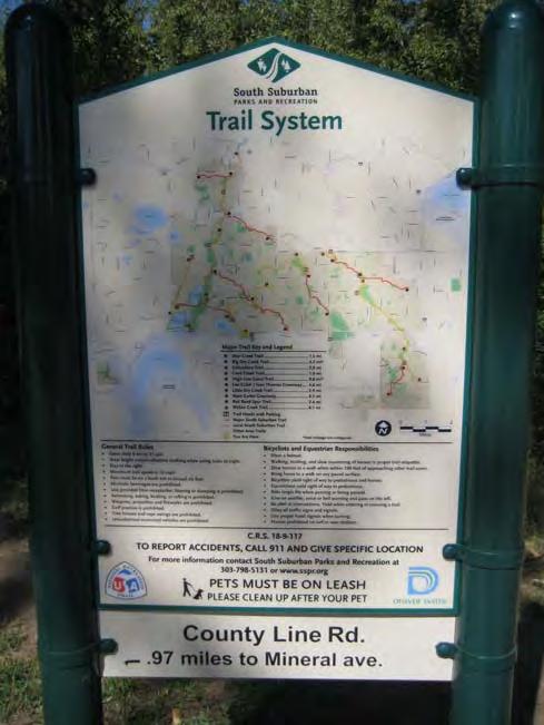
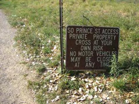
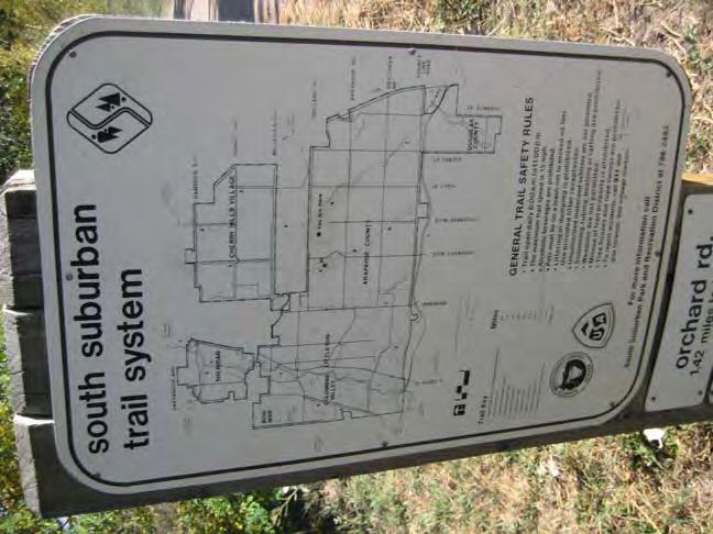
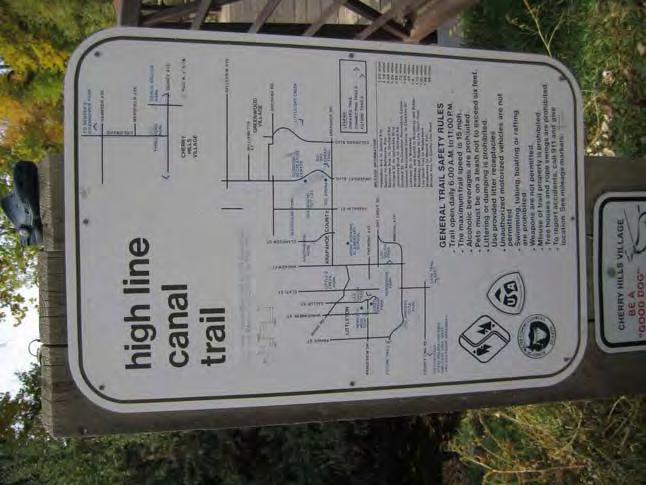
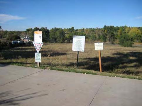
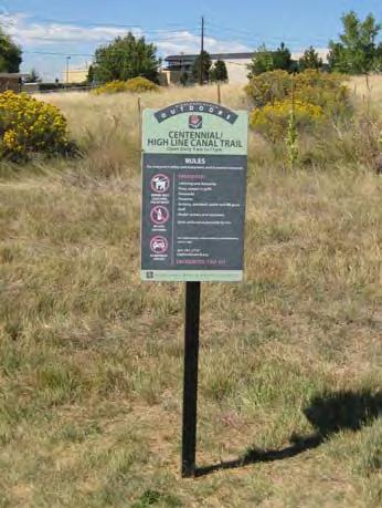
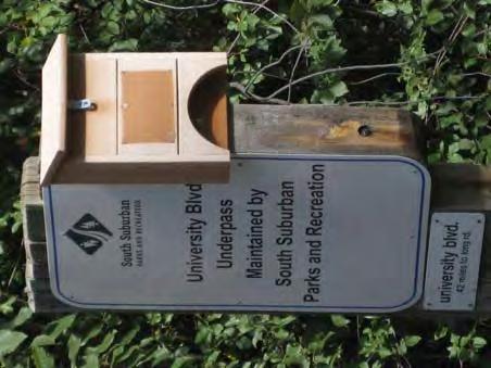
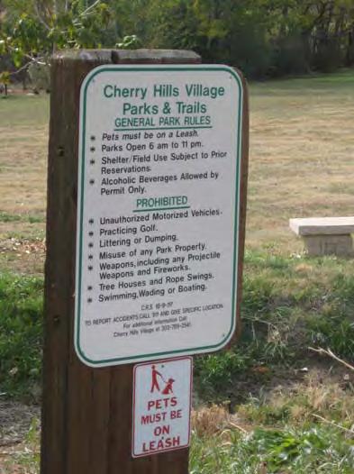
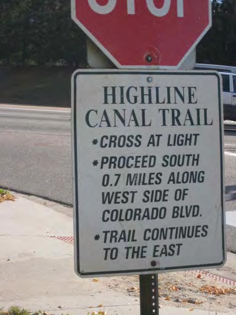
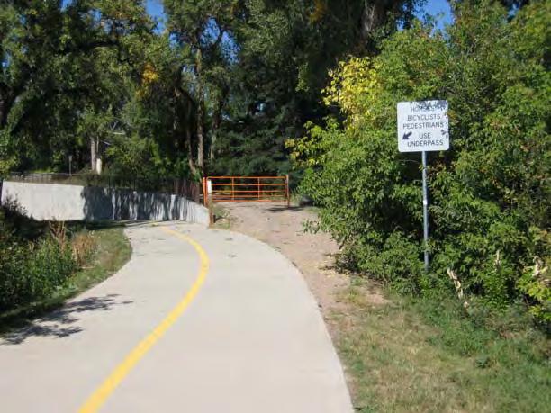
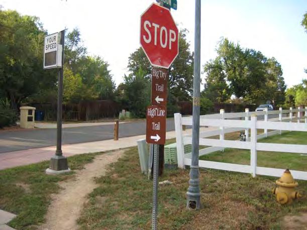
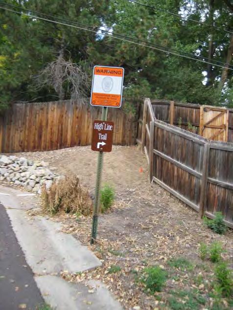
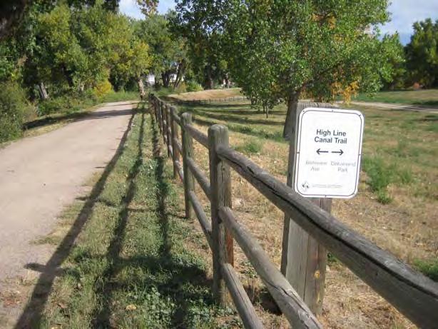
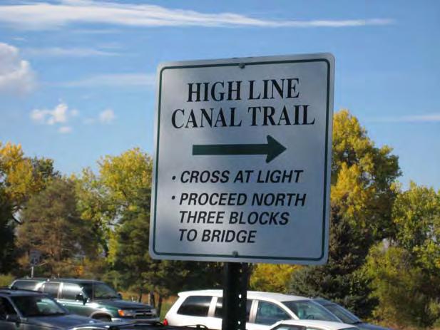
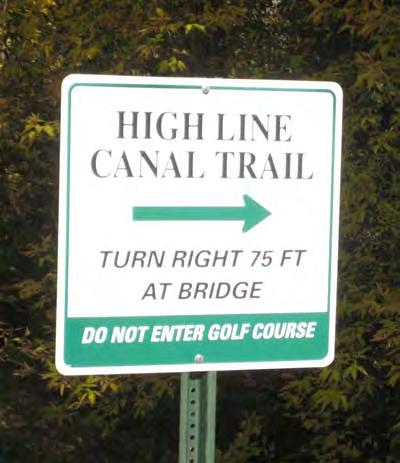
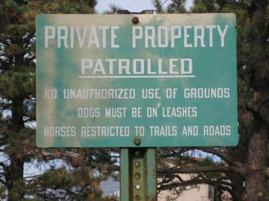
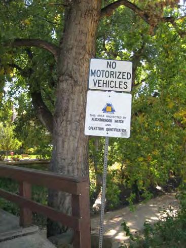
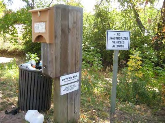
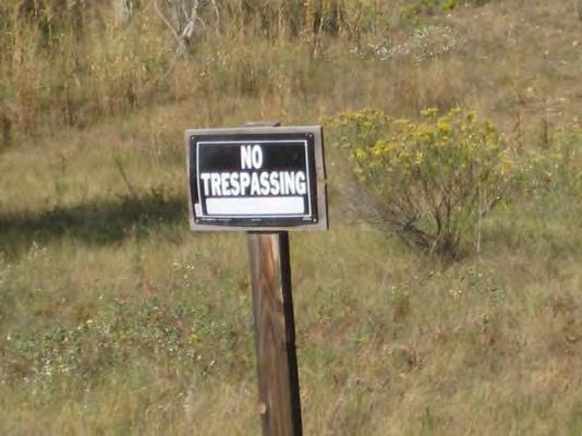
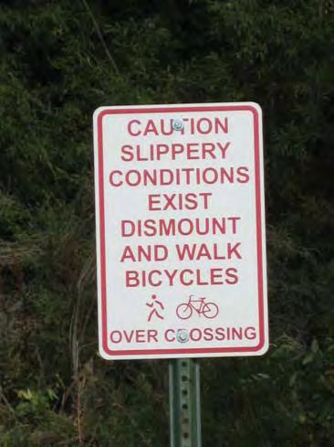
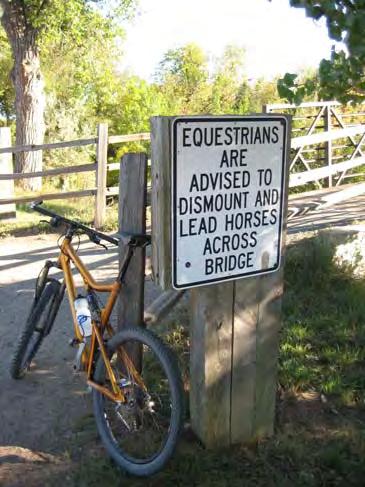
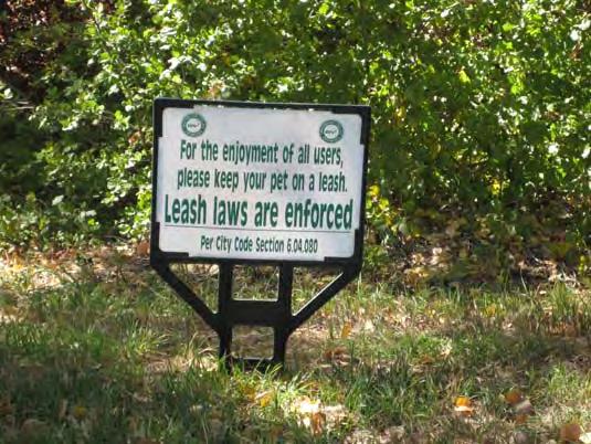
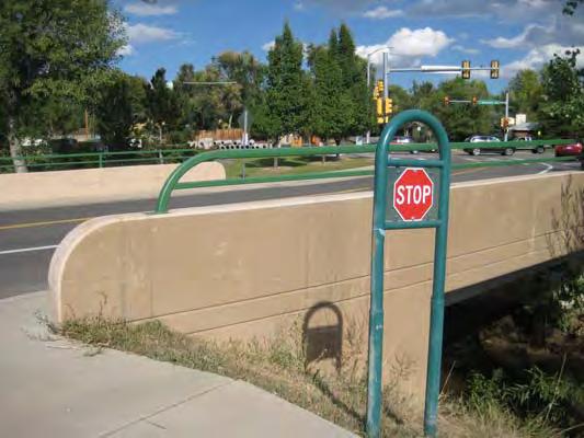
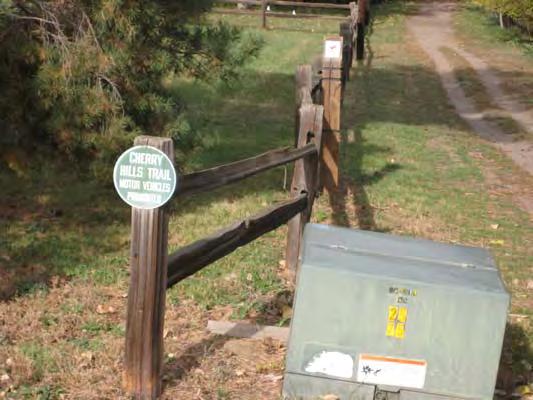
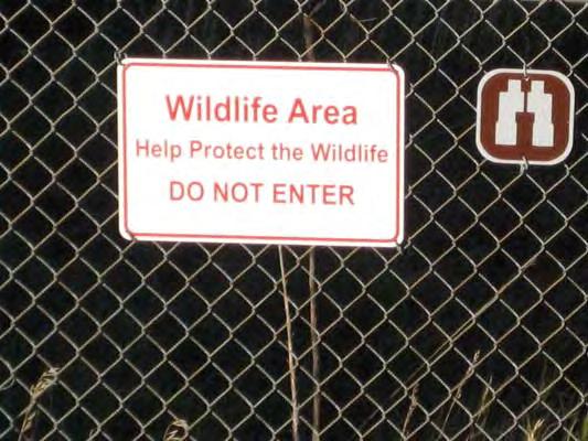
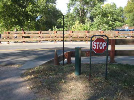
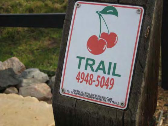
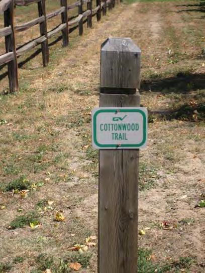
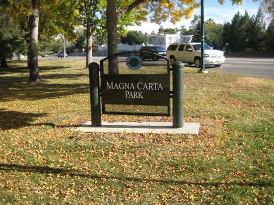
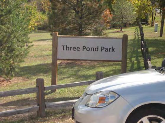
3 Signage Inventory Report Introduction The purpose of the Signage Inventory is to identify the locations and conditions of the map signs, directional signs, and mile markers to evaluate the wayfinding information currently provided for trail users along the trail. In addition, the inventory notes the design and condition of all signage to evaluate the way all information is presented to trail users. Evaluation Criteria Map signage, directional signage and mile markers were mapped along the High Line Canal Trail within the study area. Regulatory signage and identification signage was not mapped or noted on the plans, however, a photographic inventory of examples of all existing signage was prepared. Findings Existing signage along the High Line Canal can generally by categorized in five groups: informational signs, directional signs, identification signs, regulatory signs, and mile markers. Along the study area, there are numerous designs, uses, and locations for each type of sign, creating a cluttered and sometimes confusing set of information to trail users. Often, there are multiple signs installed at the same location, sometimes giving the same information. This adds to the cluttered appearance. Informational Signs Informational signage consists of maps, rules, and user information such as coyote safety information. Along the canal, the various trail management agencies install their own map and rule signs. Therefore, the sign structures vary in appearance and the content of the signs varies along the canal. Almost none of the informational signs include the words High Line Canal Trail and are not focused on the trail itself. For example, signs are labeled South Suburban Trail System or Cherry Hills Village s and Trails General Rules. As a general rule, the information provided on the signs is not focused on the High Line Canal but on the jurisdiction that installed the sign. In general, none of the map signs are particularly helpful for trail users. Many of the signs are printed at too small of a scale to be legible or useful for most users. Most of the map signs only indicate map features within the boundaries of the jurisdiction that installed the sign, with few or no features shown outside those limits. This lack of context on the maps makes it very difficult to understand where the trail will take you, and often gives no indication of how the trail fits into the local street grid, let alone the regional trail system. Rules vary from jurisdiction to jurisdiction as well. While some of the rules are similar, the variety of rules make it very difficult for users to know what the rules are at various locations along the trail. The location of informational signs also varies along the canal. They are installed at many street intersections, but not all. They are installed at some major trail intersections, but not all. Directional Signs Directional signs are utilized in several ways along the High Line Canal. Some of the signs are placed at local trail intersections to indicate which direction along the High Line Canal a user should travel to get to a certain destination (typically a street crossing, park, or regional trail). Directional signs are also used to indicate which direction trail users should go to follow the High Line Canal Trail where it varies from the alignment of the canal itself. This occurs at a few street intersections, and at the north end of the study area where the trail leaves the canal south of Hampden Ave. At these locations, the directional information is often incomplete and does not provide directional information for trail users at all locations where they need it. Identification Signs There are no signs along the study area that are in place solely to identify the High Line Canal Trail to either trail users or motorists. Most of the identification signs located along the study area are used to identify parks and other trails that are adjacent to the High Line Canal. Again, these signs vary in appearance significantly based on what jurisdiction the sign is located in. Regulatory Signs Regulatory signs are used at many locations along the study area. Their use and appearance however, is not consistent. Sign panels look different at various locations along the canal, and they are mounted on different types of structures. The cluttered and inconsistent appearance and use of regulatory signs does not deliver a clear and consistent message to trail users, making it more difficult to adhere to the regulations. Mile Markers There are various types of mile markers located along the canal. Most of the mile markers do not clearly indicate where the mileage count begins. a. High Line Canal Preservation Association mile markers: indicate every 1.0 mile; mileage count begins at Waterton Canyon. b. South Suburban s and Recreation District mile markers: indicate every 0.5 miles, mileage count begins at County Line Road and ends at Orchard Road. c. Wood bollard mile markers: these are located at various points along the study area, indicate every 0.5 miles, it is unclear where the mileage count begins, several markers are missing 1
4 These various mile markers are measuring the same segments of the High Line Canal, but measuring from different locations creating a very confusing series of mile markers. For example, along one 3 mile segment of the High Line Canal, a trail user would pass the following mile markers: 24 (HLCPA), 7.0 (SSPRD), 7.5 (SSPRD), 25 (HLCPA), 8.0 (SSPRD), 8.5 (SSPRD), 26 (HLCPA), 1.5 (Wood bollard), 27 (HLCPA). Conclusion The information compiled in this inventory will be used as a basis for the recommendations for the signage improvements. 2


 Regulatory Directional")
5 Types of Signs Used Along the High Line Canal Trail Informational (maps, rules, etc.) Identification (trailheads, parks, trails, etc.) Regulatory Directional Mile Marker Interpretive (not used in study area)

6 Informational Sign Inventory S2

7 Directional Sign Inventory S3

8 Regulatory Sign Inventory S4


9 Mile Marker and Identification Sign Inventory S5
10 Signage Improvements Report Introduction The Signage Improvements Report details the recommendations for the signage along the High Line Canal. Recommendations are made regarding the content of the signage, the design of the signage structures, and how signage is used along the canal. These recommendations are schematic and will require more detailed design work prior to implementation. Signage Design Standard The primary conclusion based on the signage inventory is that signage along the High Line Canal is very inconsistent, both in content and appearance. The result is an ineffective signage program that does not clearly convey consistent information to trail users. The solution is to develop a standard for all signage used along the High Line Canal corridor. Goals of the signage standard should include: Providing signage structures that are unique to the High Line Canal Providing a consistent appearance of all signs Providing consistent use of signage Reducing visual clutter Delivering information to users more clearly Delivering a unified message Providing signage that is easily identifiable, simple, and intuitive The signage standard should provide detailed information on the sign plaques as well as the sign structure for each type of sign used along the canal. Example Signage Design Standard The Cherry Creek Working Group recently adopted a signage standard for signage along the Cherry Creek Trail. The design utilizes a standard green color with a compass design for all of the signage structures. The same green color is used to represent the Cherry Creek Trail on the map. The design is unique to the Cherry Creek Trail and when implemented will be a visual cue for users that when they see those structures they are on the Cherry Creek Trail. This example is shown on the Signage Plans. Potential Signage Design Standards for the High Line Canal One option is to adopt a similar design to what was adopted for the Cherry Creek Trail, but with different colors. The intent would be to develop a regional transit style system where each regional trail would be identified by a specific color (i.e. Cherry Creek Trail = green, South Platte River Trail = yellow, etc.). This concept would utilize a similar design to the Cherry Creek Trail example, but use different colors for the sign structures. Example images of this option are shown on the Signage Plans. The intent would be for other regional trails to adopt a similar design in the future. Other options could be developed taking inspiration from the history, use, natural resources, or some other aspect of the canal. Utilizing a similar design and materials that are selected for the other structures such as bridges, shelters, etc. would further integrate the signage into the unique structure design for the High Line Canal corridor. Recommendations for Sign Uses/Locations As a general rule, signage should only be installed where it is absolutely necessary. Opportunities should be explored to combine multiple signs onto single posts or structures in an effort to reduce the visual clutter that numerous signs can create. For example, depending on the design of the structure, mile markers could be combined with posts for regulatory signs. Or a single signs post can hold multiple signs facing different directions. Newer technology could also be utilized on some of the signage. QR codes allow smart phone users to scan a symbol and be directed to a website with additional content. These could be included on map signs to provide a downloadable map, or on interpretive signs to deliver more indepth information. Informational Signs Informational signs (maps, rules, etc) should be installed at locations where large numbers of people are likely to enter the trail. These locations include trailheads, major street crossings, and intersections with other regional trails. They should also be installed at destination rest areas. It is not necessary to install the signs at all local street intersections because most people who access the trail at these locations are local users. Informational signs should be clearly labeled High Line Canal. Identification Signs These signs should be used to identify numerous items for both trail users and motorists. They should be used to identify the locations of trailheads for motorists. They should identify the High Line Canal Trail for motorists and pedestrians where the trail intersects major streets. The circuitous nature of the High Line Canal corridor, along with the many street crossings (often several crossings of the same street) can make it very difficult for trail users to have a good understanding of where they are in the context of the street grid. Therefore signs should be installed to identify the names of all streets that the trail crosses for trail users. Identifications signs should also be used to identify any parks, recreation centers, open spaces, or other public lands encountered along the trail. Directional Signs Directional signs should be used at intersections with other regional trails. They should also be used at any locations where the trail deviates from the alignment of the canal itself. The signs should provide sufficient directional information so that trail users can easily follow the route. 1
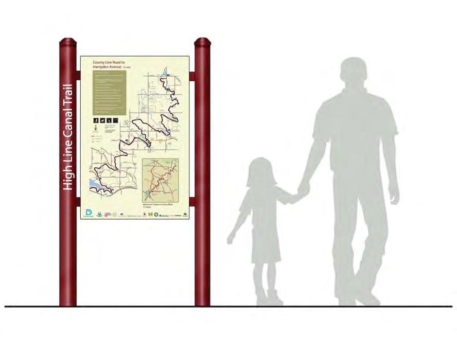
11 Regulatory Signs Regulatory signs should be installed as needed along the trail. The primary use for regulatory signage is likely to be at street intersections to warn motorists and trail users, prohibit unauthorized vehicles on the trail, etc. Interpretive Signs There currently aren t any interpretive signs along the High Line Canal within the study area. However, the rich history and cultural significance of the High Line Canal are topics that many trail users would find of interest. Interpretive signage will also provide users with a deeper appreciation for the canal, the trail, and their use of the corridor. Potential topics for interpretive signage include: the history of the canal, the construction of the canal, how water from the canal was/is used, the recreational legacy of the canal, governmental partnerships, interpretation of some of the historic structures along the canal, information about the flora and fauna that can be found along the corridor, and the ecological significance of the canal corridor. Interpretive signs should be installed at rest areas, trailheads, and other locations where users can stand off of the trail to observe the signage. Mile Markers Due to the high number of walkers and runners who utilize the trail, mile markers should be installed every ½ mile. The mileage count should start at Waterton Canyon and continue downstream. The mileage count should follow the trail rather than the canal. Map Design One of the primary goals of the signage improvements should be to improve the map signs provided along the trail. As described in the Signage Inventory Report, the current signs are generally too small, do not provide sufficient context, and are very difficult to read. along the High Line Canal Trail, location of parks near the trail corridor, locations of restrooms, trailheads, drinking water, along the trail, a simplified street map for context and to show on-street connections. The inset regional map should show the entire extent of the High Line Canal Trail and all of the regional trails that intersect the High Line Canal. It also shows major streets and landmarks such as state parks and downtown Denver. It is important to show trail users the full extent of the trail and the regional connections that can be made. This inset regional map will be the same on all of the signs. Map signs can also provide additional information such as rules and regulations and emergency phone numbers. The logos of Denver Water and all agencies responsible for providing recreation along the canal should be featured on every sign, regardless of the location of the sign. Again, the intent is develop a standard to be used along the entire corridor, and shared by all of the recreation providers. Conclusion/Next Steps The next logical step with these recommendations is to develop and adopt a detailed set of design guidelines for all signage along the High Line Canal Trail. The guidelines should provide specific requirements for the design of sign structures including construction materials, colors, dimensions, etc. They should also detail where signs should be installed, and what the sign panels will look like. A standard set of rules and a standard map design should be adopted as well. Once new signs are ready for installation, it is important to remember to remove old signage that is outdated, duplicated, or no longer pertinent. It is critical for the maps to show the regional context of the trail, but are also detailed enough to show the local connectivity. To provide this level of detail the map signs need to be much larger than the existing map signs, a minimum of 24 x36. The example map includes a main map of the local area and an inset regional map. The High Line Canal Trail is simply too long to adequately show on a single map and still provide sufficient local detail. In an effort to show sufficient detail at the local level, the main maps should show only a portion of the trail. The trail could be broken into 4 segments of approximately 15 to 20 miles of trail. Where map signs are installed, they will show only that segment of trail that the sign is installed. The 4 segments could be: Waterton Canyon to County Line Road, County Line Road to Hampden Ave., Hampden Ave. to I-225, I-225 to Pena Boulevard. The example sign developed as part of this study show the County Line Road to Hampden Ave segment. The maps should emphasize the information that trail users most need. The signs should show: the location of the High Line Canal Trail, the location and name of other regional trails, mileage 2

12 County Line Road to Hampden Avenue 19 miles Be friendly and courteous. Share the trail. Ride, walk, or run on the right, pass on the left. E. HAMPDEN AVE. Wellshire Golf Course Magna Carta High Line Canal Trail Jackass Hill Stay on the trail. Creating your own trail creates erosion, damages habitat, and causes new trails which cannot be maintained. Bicyclists yield to runners and hikers. All users yield to equestrians. Keep your bike under control and at a safe speed. Downhill traffic should yield to uphill traffic. When in doubt, give the other user the right-of-way. Announce or alert when you are planning to pass. Anticipate other trail users around corners and blind spots. Respect wildlife by keeping your distance. Use caution when using headphones. You may not be able to hear people trying to warn you. Respect private property. N March, 2012 Map is not to scale High Line Canal Trail Other regional trails Mileage marker Trail hours: dawn to dusk To report an emergency call 911 To report unsafe conditions or maintenance issues call 303-XXX-XXXX E. MINERAL AVE. S. BROADWAY S. PRINCE ST. TO SOUTH PLATTE RIVER TRAIL W. RANGEVIEW DR. Writer s Vista Lower Ridgewood Southbridge 18m/ 29.0k Carbone W. GEDDES AVE. W. CALEY AVE. S. ELATI ST. CLARKSON ST. E. DRY CREEK RD. W. COUNTY LINE RD. E. ARAPAHOE RD. E. ORCHARD RD. E. BELLEVIEW AVE. BEAR CREEK TRAIL S. UNIVERSTIY BLVD. 76 DRY GULCH TRAIL S. PLATTE RIVER TRAIL S. SANTA FE DR. 25 Downtown Denver BIG DRY CREEK TRAIL E. QUINCY AVE. E. LONG RD. BIG DRY CREEK TRAIL 36 CHERRY CREEK TRAIL S. COLORADO BLVD. SAND CREEK GREENWAY TRAIL Cherry Creek Reservoir S. COLORADO BLVD. S. UNIVSERSITY BLVD. S. FRANKLIN ST. S. CLARKSON ST. S. VINE ST. S. STEELE ST. S. FRANKLIN ST. S. WINDEMERE ST. Ashbaugh 19m/ 30.6k S. WINDEMERE ST. LEE GULCH TRAIL Horseshoe 17m/ 27.4k S. ELATI ST. Little s Creek 21m/ 33.8k 20m/ 32.2k S. BROADWAY S. BROADWAY 22m/ 35.4k BIG DRY CREEK TRAIL Brookridge 23m/ 37.0k E. GEDDES AVE. Horsemans Milliken E. COSTILLA AVE. Puma You Are Here LEE GULCH TRAIL S. CLARKSON ST. Clarkson S. CLARKSON ST. 27m/ 43.5k Southglenn Country Club DeKoevend 24m/ 38.6k Cherry Hills Country Club Woody Hollow 26m/ 41.9k Curtis John Meade 25m/ 40.2k 28m/ 45.1k CENTENNIAL REGIONAL LINK TRAIL BIG DRY CREEK TRAIL Cherry Knolls 30m/ 48.2k Glenmoor Country Club E. CALEY AVE. Chapel Hill Memorial Gardens 36m/ 57.9k 35m/ 56.3k Three Pond 31m/ 49.9k 29m/ 46.7k Rocky Mountain Arsenal National Wildlife Refuge Little Dry Creek m/ 54.7k Cherry Creek State EAST TOLLGATE CREEK TRAIL Dahlia Hollow CHERRY CREEK TRAIL Marjorie Perry Nature Preserve LITTLE DRY CREEK TRAIL PENA BLVD. 33m/ 53.1k 32m/ 51.5k E-470 HAPPY CANYON RD. C-470 TRAIL C-470 TRAIL C-470 C-470 Chatfield Reservoir Chatfield State County Line Rd. to Hampden Ave. 19 miles E-470 To Castlewood Canyon State Waterton Canyon to Pena Blvd. 71 miles City of CHERRY HILLS VILLAGE


13 Origins and Legacy Agricultural Vision James Duff, a Colorado resident and businessman developed the idea for constructing a canal to serve land owners on the plains in His vision was to develop a commercial venture that would convert the arid plains east of Denver into profitable agricultural land. He secured English investors and the canal started construction in the spring of The canal was constructed by the Northern Colorado Irrigation Company. The Canal Runs Dry High Line Canal Facts Years Built: 1880 to 1883 Cost to Construct: $650,000 As history would show, the High Line Canal would never reach its potential as an irrigation ditch. The owners of the canal were never able to secure more than junior water rights. In fact, 74 other canals in the South Platte River watershed held more senior water rights than the High Line Canal. As a result, the High Line Canal did not provide a reliable source of water, and sometimes ran dry. While the agricultural development that was meant to be fed by the High Line Canal never materialized, water from the canal did encourage the growth of Denver and its suburbs. Why High Line? The High Line Canal is named for the engineering principle that allows the canal to transport water 71 miles from Waterton Canyon to NE Denver entirely by gravity flow thus eliminating the need for pumps. Using the high line principle, the canal follows the contour of the land to minimize the drop in elevation along it course. This results in the curvilinear course of the canal. Recreational Legacy Over the years, water flowing through the High Line Canal has created its own ecosystem. Towering cottonwoods and willow trees along with an understory of shrubs and grasses now grow where they could not without the canal. Hundreds of species of birds, and dozens of species of mammals and lizards live along the long, narrow ecosystem. A ditch rider s maintenance road follows along the canal for its entire length. For years, this road was closed to the public. Starting in 1970, Denver Water worked with local municipalities to open the ditch rider s road as a public trail. Today, nearly 60 miles of that road have been improved for use as a recreation trail. While Duff s original vision for the canal was a failure, he unknowingly left us an important legacy a wonderful serpentine trail and open space corridor through our community. Original Length: 71 miles Starting Elevation: 5,542 Ending Elevation: 5,410 Average Drop in Elevation per Mile: 2 Total Drop in Elevation along Canal: 132 Average Width: 30 Year Denver Water began managing the canal: 1924 Year canal corridor was opened to the public for trail use: 1970


14 Transit System Concept Directional Signs Informational Signs SIGNAGE RECOMMENDATIONS Mile Marker Mile Marker with Regulatory Sign S7
Regional Wayfinding Sign Strategy Thurston County Trails 2017
 Regional Wayfinding Sign Strategy Thurston County Trails 2017 Partners: Members and partnering organizations of the Thurston Thrives Community Design Action Team City of Lacey, City of Olympia, City of
Longmont to Boulder Regional Trail Jay Road Connection DRAFT FINAL REPORT
 Longmont to Boulder Regional Trail Jay Road Connection DRAFT FINAL REPORT December 2018 Project Summary Boulder County, Colorado, in partnership with the City of Boulder, is evaluating options for multi-use
Business Item No XXX. Proposed Action That the Metropolitan Council approve the Coon Creek Regional Trail Master Plan.
 Business Item No. 2015-XXX Metropolitan Parks and Open Space Commission Meeting date: July 7, 2015 For the Community Development Committee meeting of July 20, 2015 For the Metropolitan Council meeting
EXECUTIVE SUMMARY PROGRAM DEVELOPMENT REPORT PURPOSE EXISTING SETTING EXPANDING PARKLAND
 EXECUTIVE SUMMARY PROGRAM DEVELOPMENT REPORT PURPOSE As the culmination of the first phase of the master planning process, this Program Development Report creates the framework to develop the Calero County
Staff Report Sign Design
 Staff Report Sign Design July 29, 2014 Planning & Zoning Commission Meeting Report date July 23, 2014 Project type Sign Design Legal description Section 2, Township 5, Range 82 Lots 3&4, S1/2NW1/4, SW1/4
TORONTO TRANSIT COMMISSION REPORT NO. SUBJECT: TORONTO-YORK SPADINA SUBWAY EXTENSION STATION NAMES IN THE CITY OF VAUGHAN
 TORONTO TRANSIT COMMISSION REPORT NO. MEETING DATE: February 29, 2011 SUBJECT: TORONTO-YORK SPADINA SUBWAY EXTENSION STATION NAMES IN THE CITY OF VAUGHAN ACTION ITEM RECOMMENDATIONS It is recommended that
City of Durango 5.8 FUNDING TRAILS DEVELOPMENT
 5.8 FUNDING TRAILS DEVELOPMENT The City has been successful in establishing dedicated local funding sources as well as applying for grants to develop the City s trail system, having received nearly $2.4
MPRB: Southwest LRT Community Advisory Committee Issues and Outcomes by Location Current to: 12 November 2010
 MPRB: Southwest LRT Community Advisory Committee Issues and Outcomes by Location Current to: 12 November 2010 This is a compilation of issues and outcomes identified by the CAC. It is a work in progress,
MUNICIPALITY OF ANCHORAGE
 MUNICIPALITY OF ANCHORAGE ANCHORAGE PARKS & RECREATION Memorandum PRC 08-56 DATE: 5 August 2008 TO: FROM: SUBJECT: Parks & Recreation Commission Holly Spoth-Torres, Park Planner PRC 08-56 Far North Bicentennial
FEASIBILITY CRITERIA
 This chapter describes the methodology and criteria used to evaluate the feasibility of developing trails throughout the study areas. Land availability, habitat sensitivity, roadway crossings and on-street
Waukee Trailhead Public Art and Amenities Project
 Waukee - Trailhead Public Art and Amenities Project Sponsor Waukee Project Title Waukee Trailhead Public Art and Amenities Project Termini Description ( i.e. Park Avenue to 19th Street) NE Intersection
Trails Technical Committee
 Trails Technical Committee Winter 2017 Draft Report Alignment Proposals for the Inyo National Forest and the Town of Mammoth Lakes Map ID #S18 February 08, 2017 Map ID #S18 Key Agreements As of February
FINAL TESTIMONY 1 COMMITTEE ON RESOURCES UNITED STATES HOUSE OF REPRESENTATIVES. July 13, 2005 CONCERNING. Motorized Recreational Use of Federal Lands
 FINAL TESTIMONY 1 STATEMENT OF DALE BOSWORTH CHIEF Of the FOREST SERVICE UNITED STATES DEPARTMENT OF AGRICULTURE Before the SUBCOMMITTEE ON FORESTS AND FOREST HEALTH And the SUBCOMMITTEE ON NATIONAL PARKS,
Committee Report. Community Development Committee For the Metropolitan Council meeting of August 12, Business Item No.
 Committee Report Business Item No. 2015-168 Community Development Committee For the Metropolitan Council meeting of August 12, 2015 Subject: Coon Creek Regional Trail Master Plan, Anoka County Proposed
The Chu property is a 6.57 acre parcel located in the Town of Superior on the west side of McCaslin Boulevard. In 2014, the Town of Superior acquired
 1 The Chu property is a 6.57 acre parcel located in the Town of Superior on the west side of McCaslin Boulevard. In 2014, the Town of Superior acquired the Chu property for open space with a contribution
Dungeness Recreation Area County Park Master Plan
 Dungeness Recreation Area County Park Public Outreach Meeting October 10, 2007 Project Overview USFWS Site Dungeness Recreation Area County Park Meeting Objectives: Re-Introduce project; provide status
URBAN DESIGN REPORT. Proposed Residential Development, Old Church Road, Caledon East
 Proposed Residential Development, Old Church Road, Caledon East TABLE CONTENTS: 1.0 DEVELOPMENT 1.1 Introduction-Analysis of Guiding Principles and Documents 1.2 Community Design and Architectural Design
The Vision for the San Juan Islands Scenic Byway
 The Vision for the San Juan Islands Scenic Byway 2 Judd Cove, Orcas Island, Courtesy of Kurt Thorson (kurtthorson.com) and San Juan County Land Bank Vision for the San Juan Islands Scenic Byway The San
PROPOSED ACTION South 3000 East Salt Lake City, UT United States Department of Agriculture
 United States Department of Agriculture Forest Service Uinta-Wasatch-Cache National Forest Salt Lake Ranger District 6944 South 3000 East Salt Lake City, UT 84121 801-733-2660 File Code: 1950/2300 Date:
Nov. 19 th Public Workshop Summary
 On November 19 th, more than 60 community members attended an Open Space Matters workshop at the Linen Building in downtown Boise for over two hours. Participants learned about reserves, discussed the
Tracy Ridge Shared Use Trails and Plan Amendment Project
 Tracy Ridge Shared Use Trails and Plan Amendment Project Scoping Document Forest Service Allegheny National Forest Bradford Ranger District McKean, County, Pennsylvania In accordance with Federal civil
Wayfinding and Signage Study
 Wayfinding and Signage Study This appendix provides background information regagarding wayfinding and signage nees along the Bayshore Heritage Byway route. Billboards, other off- premise signs and similar
Appendix 3. Greenway Design Standards. The Whitemarsh Township Greenway Plan
 Appendix 3 Greenway Design Standards This chapter discusses two design standards for the greenway types discussed above. First, trail design standards are presented together with trailhead facilities and
RUSHMORE CONNECTOR TRAIL PROPOSAL
 PURPOSE AND NEED Background The U.S. Forest Service, Black Hills National Forest (Forest Service) has received a special use permit application from the State of South Dakota Department of Game, Fish and
Continental Divide National Scenic Trail Legislative History and Planning Guidance
 Continental Divide National Scenic Trail Legislative History and Planning Guidance Legislation, Policy, and Direction Regarding National Scenic Trails The National Trails System Act, P.L. 90-543, was passed
America s Great Outdoors: Feasibility Study for Connecting Urban Refuges to the Rocky Mountain Greenway Trail Network
 Case 1:18-cv-01017-PAB Document 7-17 Filed 05/31/18 USDC Colorado Page 1 of 42 America s Great Outdoors: for Connecting Urban Refuges to the Rocky Mountain Greenway Trail Network Rocky Flats and Two Ponds
Colorado s Instream Flow Program at 40. ICWP Annual Conference October 16, 2013 Denver, Colorado
 Colorado s Instream Flow Program at 40 ICWP Annual Conference October 16, 2013 Denver, Colorado ISF Program established in 1973 by Senate Bill 97 Recognized the need to correlate the activities of mankind
HIGHWAY 17 WILDLIFE and REGIONAL TRAIL CROSSINGS
 HIGHWAY 17 WILDLIFE and REGIONAL TRAIL CROSSINGS Agenda and Meeting Format 7:00-7:15 Welcome 7:15-8:00 Presentation 8:00-8:30 Open House 8:30 Recap 9:00 Conclusion 2 Meeting Goals: Introduce the project
County of Elgin Tourism Signage Policy Addendum A
 1.0 INTRODUCTION County of Elgin Tourism Signage Policy Addendum A 1.1 PURPOSE OF ELGIN TOURISM SIGNAGE POLICY To define the eligibility, use, design and authority for tourism oriented directional signage
2. Goals and Policies. The following are the adopted Parks and Trails Goals for Stillwater Township:
 D. PARKS AND TRAILS 1. Introduction Stillwater Township s population is relatively low, with most residents living on rural residences on large lots. The need for active park space has been minimal in
Greening Project Status Report: Grand Canyon National Park
 Greening Project Status Report: Grand Canyon National Park Prepared for the Federal Energy Management Program U.S. Department of Energy February 2001 iii Contents Page 1. Introduction... 1 2. Context of
Stephens Rd. Nature Preserve
 Stephens Rd. Nature Preserve History Stephens Road Nature Preserve (SRNP) is a 350-acre nature preserve in Huntersville that comprises nine properties purchased between 1994 and 2008. Parcels included
TORONTO TRANSIT COMMISSION REPORT NO.
 Form Revised: February 2005 TORONTO TRANSIT COMMISSION REPORT NO. MEETING DATE: November 23, 2011 SUBJECT: TORONTO-YORK SPADINA SUBWAY EXTENSION STATION NAMES FOLLOW-UP REPORT ACTION ITEM RECOMMENDATIONS
Welcome to the Cross County Trail Public Input Session!
 Welcome to the Cross County Trail Public Input Session! Please sign in on the table below! What are we doing here? Camden County has proposed a bicycle and pedestrian trail spanning across the entire county.
2018 Service Changes Ada County
 2018 Service Changes Ada County System Benefits 15 minute headways on State Street during peak hours o 30 minutes on Saturdays 30 minute headways on Emerald all day on weekdays More frequent and direct
SECTION ARAPAHOE COUNTY SCHEDULE 2 STREAM MANAGEMENT SCHEDULE
 SECTION 01320 ARAPAHOE COUNTY SCHEDULE 2 STREAM MANAGEMENT SCHEDULE CONTACTOR: VALLES CONSTRUCTION STREAM MANAGEMENT AGREEMENT NO. 18-01.04 Week starting on Monday of: BEAR CREEK Reach: Confl. w/s. Platte
Chapter 6: POLICY AND PROCEDURE RECOMMENDATIONS
 Chapter 6 POLICY AND PROCEDURE RECOMMENDATIONS FOR SRRA Below are seven policy elements that should be considered for adoption by the Southwest Regional Recreation Authority of Virginia: 1. Develop strategies
Centennial Airport Flight school practice areas. A PowerPoint Presentation By Michael Shannon Chief Flight Instructor Aspen Flying Club
 Centennial Airport Flight school practice areas A PowerPoint Presentation By Michael Shannon Chief Flight Instructor Aspen Flying Club The Denver metro area airspace is very complex and congested. Centennial
Council Policy Tourist Oriented Destination Signs
 POLICY 373 APPROVED @ City of Kelowna 1435 Water Street Kelowna, BC V1Y 1J4 250 469-8500 kelowna.ca Council Policy Tourist Oriented Destination Signs Contact Department: Civic Operations Traffic Operations
CHAPTER 5. Chapter 5 Recreation Element
 CHAPTER 5 Recreation Element Chapter 5 Recreation Element The Recreation Element of the Meyers Area Plan is a supplement to the Recreation Element of the TRPA Regional Plan and the El Dorado County General
2012 Mat Su Valley Collision Avoidance Survey
 Table of Contents Table of Contents 1 INTRODUCTION Measurement Objectives 3 Methodology and Notes 4 Key Findings 5 PILOT LOCATION Activity in the Area 7 Pilot Location 8 Altitudes Flown 9 SAFETY IN THE
ARAPAHOE COUNTY TOTAL FUNDS- $1,747,290 10/13/2017
 2018 Steam Management Work Plan ARAPAHOE COUNTY TOTAL FUNDS- 1,747,290 10/13/2017 Vegetation Management and Debris Removal General Services PLAN DRAINAGEWAY NAME- LOCAL NEARBY PLAN 1 BEAR CREEK SHERIDAN
Preferred Recreation Recommendations Stemilt-Squilchuck Recreation Plan March 2018
 Preferred Recreation Recommendations Stemilt-Squilchuck Recreation Plan March 2018 Below are the recommended recreation ideas and strategies that package together the various recreation concepts compiled
Greenbelt Route Signage Guidelines
 Greenbelt Route Signage Guidelines Revised March 31, 2015 Waterfront Regeneration Trust (416) 943-8080 info@wrtrust.com Greenbelt Foundation (416) 960-0001 info@greenbelt.ca www.greenbeltcycles.com Greenbelt
Business Item No
 Metropolitan Parks and Open Space Commission Meeting date: February 6, 2018 For the Community Development Committee meeting of February 20, 2018 For the Metropolitan Council meeting of February 28, 2018
Thornton Water Project. Larimer County Route Study and Project Update September 12, 2017
 Thornton Water Project Larimer County Route Study and Project Update September 12, 2017 Purpose of Meeting Provide information on the Thornton Water Project Present the results of the pipeline routing
Committee. Presentation Outline
 CW-33-15 11/9/2015 Community and Corporate Services Committee November 10, 2015 1 Presentation Outline Background Vision and Objectives Study Process and Timeline Public and Stakeholder Engagement Organization
Establishing a National Urban Park in the Rouge Valley
 STAFF REPORT ACTION REQUIRED Establishing a National Urban Park in the Rouge Valley Date: March 29, 2012 To: From: Wards: Reference Number: Executive Committee Deputy City Manager, Cluster B All p:\2012\cluster
Welcome KROSNO CREEK DIVERSION PROJECT CLASS ENVIRONMENTAL ASSESSMENT
 Welcome KROSNO CREEK DIVERSION PROJECT PUBLIC INFORMATION CENTRE # 1 Tonight s Presentation Study Overview Background Existing Conditions Alternative Solutions Preliminary Preferred Solution Next Steps
Section II. Planning & Public Process Planning for the Baker/Carver Regional Trail began in 2010 as a City of Minnetrista initiative.
 Section II Planning & Public Process Planning for the began in 2010 as a City of initiative. city staff began discussions with the Park District on the possibility of a north/south regional trail connection
BACKCOUNTRY TRAIL FLOOD REHABILITATION PROGRAM
 BACKCOUNTRY TRAIL FLOOD REHABILITATION PROGRAM Backcountry Trail Flood Rehabilitation A June 2013 Flood Recovery Program Summary In June 2013, parts of Southern Alberta were devastated from significant
Trans Canada Trail Signage Guidelines MADE BY CANADA
 Trans Canada Trail Signage Guidelines MADE BY CANADA Mission: We will promote and assist in the development and use of the Trans Canada Trail by supporting success at the local level in the creation of
January 14, Orange County Transportation Authority Attn: M2 NCCP/HCP 550 South Main Street P.O. Box Orange, CA
 Equestrian Trails, Inc. Corral 357 P.O. Box 1026 Trabuco Canyon, CA 92678 http://saddlebackcanyonriders.com/ President: James Iacono... 714-612-1789 January 14, 2016 Orange County Transportation Authority
ROAD AND TRAIL PROJECT APPROVAL
 ROAD AND TRAIL PROJECT APPROVAL www.marincountyparks.org Marin County Parks, 3501 Civic Center Dr, Suite 260, San Rafael, CA 94903 DATE: July 12, 2017 PRESERVE: Gary Giacomini Open Space Preserve PROJECT:
Committee Report. Community Development Committee For the Metropolitan Council meeting of April 13, Business Item No.
 Committee Report Business Item No. 2016-48 Community Development Committee For the Metropolitan Council meeting of April 13, 2016 Subject: Harriet Island-South St. Paul Regional Trail Master Plan, Saint
Trail Assessment Report
 Trail Assessment Report Trail Options for the Bear Creek Canyon located in Pikes Peak Ranger District, Pike National Forest and on Colorado Springs Utility Lands Due to the presence of a unique species
Parkland County Municipal Development Plan Amendment Acheson Industrial Area Structure Plan
 Parkland County Municipal Development Plan Amendment Acheson Industrial Area Structure Plan New Plan Acheson Industrial Area Structure Plan Amendment Parkland County Municipal Development Plan Board Reference
RE: Access Fund Comments on Yosemite National Park Wilderness Stewardship Plan, Preliminary Ideas and Concepts
 September 30, 2016 Superintendent Yosemite National Park Attn: Wilderness Stewardship Plan P.O. Box 577 Yosemite, CA 95389 RE: Access Fund Comments on Yosemite National Park Wilderness Stewardship Plan,
Proposal to Redevelop Lower Kananaskis River-Barrier Lake. Bow Valley Provincial Park
 Frequently Asked Questions Proposal to Redevelop Lower Kananaskis River-Barrier Lake Bow Valley Provincial Park Frequently Asked Questions What has been decided? What are the details of the plan? What
DRAFT - APRIL 13, 2007 ROUTING STUDY FOR TRAIL CONNECTIONS BETWEEN CALAIS AND AYERS JUNCTION
 DRAFT - APRIL 13, 2007 ROUTING STUDY FOR TRAIL CONNECTIONS BETWEEN CALAIS AND AYERS JUNCTION Abstract The vision for the East Coast Greenway is an off-road urban trail system running from Calais, Maine
COMMUNITY GUIDE & REPORT
 Arapahoe County Open Spaces COMMUNITY GUIDE & REPORT Dear Arapahoe County Citizens, Did you know that for every $100 you spend in Arapahoe County, 25 cents is reinvested into our beautiful parks, trails
Chapel Hill Transit: Short Range Transit Plan. Preferred Alternative DRAFT
 : Short Range Transit Plan Preferred Alternative August 2018 Table of Contents Executive Summary... 1 Preferred Alternative... 3 Best Practices for Route Design... 3 Project Goals... 4 Preferred Alternative...
AGENDA ITEM 5 D WAKULLA ENVIRONMENTAL INSTITUTE (WEI) TRAIL FEASIBILITY STUDY
 TRAIL FEASIBILITY STUDY") March 19, 2018 AGENDA ITEM 5 D WAKULLA ENVIRONMENTAL INSTITUTE (WEI) TRAIL FEASIBILITY STUDY TYPE OF ITEM: Action STATEMENT OF ISSUE The Wakulla Environmental Institute (WEI) Trail is one of several trails
March 19, 2018 AGENDA ITEM 5 D WAKULLA ENVIRONMENTAL INSTITUTE (WEI) TRAIL FEASIBILITY STUDY TYPE OF ITEM: Action STATEMENT OF ISSUE The Wakulla Environmental Institute (WEI) Trail is one of several trails
Figure 1: Little Dry Creek Trail Crossing
 Figure 1: Little Dry Creek Trail Crossing Figure 2: Little Dry Creek Trail Crossing Northwest Rail Environmental Evaluation Temporary Trail Detour Concurrence Form Adams County, Little Dry Creek Trail
Hermosa Area Preservation The Colorado Trail Foundation 4/11/2008
 Hermosa Area Preservation The Colorado Trail Foundation 4/11/2008 Legend d o Tr ail NPA - National Protection Area ra NCA - National Conservation Area o e C Th The Colorado Trail lo FS inventoried Roadless
13.1 REGIONAL TOURISM ISSUES AND SUMMARY OF FINDINGS
 13 REGIONAL TOURISM T he County of Mariposa s recreation needs and facilities fall within two categories: regional tourism and local recreation. This Element focuses on regional tourism issues related
CHAPTER 1 TRANSIT MARKET AREAS AND EXISTING SERVICE
 CHAPTER 1 TRANSIT MARKET AREAS AND EXISTING SERVICE Transit Market Areas While several factors influence the propensity to use transit, the primary predictors of transit productivity are the density of
Stephens State Park Trails
 TRAILS OF ALLAMUCHY MOUNTAIN & STEPHENS STATE PARKS Allamuchy Mountain and Stephens State Parks contain 28 marked trails providing access to diverse landscapes for walking, hiking, biking, bird-watching,
1 PROJECT STATUS UPDATE 2 ND CONCESSION FROM BRISTOL ROAD TO DOANE ROAD TOWNS OF EAST GWILLIMBURY AND NEWMARKET
 Report No. 3 of the Regional Council Meeting of March 28, 2013 1 PROJECT STATUS UPDATE 2 ND CONCESSION FROM BRISTOL ROAD TO DOANE ROAD TOWNS OF EAST GWILLIMBURY AND NEWMARKET The recommends: 1. Receipt
CITY COUNCIL AGENDA MEMORANDUM
 To: Mayor and City Council From: Charles Ozaki, City and County Manager Prepared By: Kevin Standbridge, Deputy City and County Manager Katie Allen, City and County Engineer David Shinneman, Community Development
The Future of the Road to Revolutions. A Battle Road Scenic Byway Public Forum November 9, 2010
 The Future of the Road to Revolutions A Battle Road Scenic Byway Public Forum November 9, 2010 Who is the Battle Road Scenic Byway? Four Towns: Arlington, Lexington, Lincoln, Concord Minute Man National
Trail Etiquette. Hours of Operation. Trail Accessibility
 Trail Guide The Elmhurst Park District, with 28 parks and over 460 acres of land, offers nearly six miles of paved or asphalt park trails and maintains an additional 3.6 miles of trails within Elmhurst.
Chatsworth Branch Library Devonshire Street, Chatsworth, CA Thursday, November 16, :00-8:00 pm
 Chatsworth Branch Library 21052 Devonshire Street, Chatsworth, CA 91311 Thursday, November 16, 2017 6:00-8:00 pm Project Team County of Los Angeles Department of Parks and Recreation Kathline King Chief
LESLIE BARNS & CONNECTION TRACK. Project Update Construction and Traffic Management Consultation
 LESLIE BARNS & CONNECTION TRACK Project Update Construction and Traffic Management Consultation PRESENTATION SUMMARY Part 1 Brief Project Update (New Streetcars & Streetscape Improvements) Part 2 Construction
Bibbulmun Track. Cape to Cape Track. Two of the world s great long distance walking tracks. 973 km. 135 km km Off-road cycle touring
 Trail revitalising Western Australia Bibbulmun Track 973 km Cape to Cape Track 135 km Two of the world s great long distance walking tracks 1062 km Off-road cycle touring Trail revitalising 1. Framework
A CASE FOR COMPLETING THE JORDAN RIVER PARKWAY: A
 A CASE FOR COMPLETING THE JORDAN RIVER PARKWAY: A safe crossing at 9000 South and 850 West Proposed 9000 South Underpass Parkway Timeline Parkway, Trail, and Tourism Facts Blueprint Jordan River 1971 1973
Welcome and thank you for being here! Kick-Off Public Workshop November 19, 2014
 Welcome and thank you for being here! Kick-Off Public Workshop November 19, 2014 OPEN SPACE MATTERS: Boise s First Reserve Master Plan Julia Grant Foothills and Open Space Manager City of Boise Ellen Campfield
Logo Department Name Agency Organization Organization Address Information 5700 North Sabino Canyon Road
 Logo Department Name Agency Organization Organization Address Information United States Forest Coronado National Forest 5700 North Sabino Canyon Road Department of Service Santa Catalina Ranger District
Coronado National Forest Santa Catalina Ranger District
 United States Department of Agriculture Forest Service Coronado National Forest Santa Catalina Ranger District File Code: 1950 Date: October 14, 2015 Dear Interested Party: The Santa Catalina Ranger District
Trail Use in the N.C. Museum of Art Park:
 Trail Use in the N.C. Museum of Art Park: New Connections, New Visitors Jacqueline MacDonald Gibson, PhD Daniel Rodriguez, PhD Taylor Dennerlein, MSEE, MCRP, EIT Jill Mead, MPH Evan Comen University of
NCUTCD Proposal for Changes to the Manual on Uniform Traffic Control Devices
 1 2 3 4 5 6 7 8 9 10 11 12 13 14 15 16 17 18 19 20 21 22 23 24 25 26 27 28 29 30 31 32 TECHNICAL COMMITTEE: ITEM NUMBER: TOPIC: ORIGIN OF REQUEST: AFFECTED SECTIONS OF MUTCD: NCUTCD Proposal for Changes
Airport Planning Area
 PLANNING AREA POLICIES l AIRPORT Airport Planning Area LOCATION AND CONTEXT The Airport Planning Area ( Airport area ) is a key part of Boise s economy and transportation network; it features a multi-purpose
ANCLOTE COASTAL TRAIL ALTERNATIVES ANALYSIS STUDY
 ANCLOTE COASTAL TRAIL ALTERNATIVES ANALYSIS STUDY PASCO COUNTY MPO JULY 2015 PROJECT OVERVIEW... INTRODUCTION EXECUTIVE SUMMARY CONTEXT... TAMPA BAY AREA, PINELLAS, & PASCO COUNTY S MULTI-USE TRAIL PLANS
Restore and implement protected status that is equivalent, or better than what was lost during the mid-1990 s
 THE ROSSLAND RANGE, OLD GLORY AREA. Executive summary. The Friends of the Rossland Range Society, on behalf of the local outdoor community, seeks to accomplish the following with respect to the Old Glory
Stevenson Ranch Library The Old Road, Stevenson Ranch, CA Thursday, November 9, :00-8:00 pm
 Stevenson Ranch Library 25950 The Old Road, Stevenson Ranch, CA 91381 Thursday, November 9, 2017 6:00-8:00 pm Project Team County of Los Angeles Department of Parks and Recreation Kathline King Chief of
Hudson Highlands Fjord Trail Draft Master Plan. April 29, 2015
 Hudson Highlands Fjord Trail Draft Master Plan April 29, 2015 Agenda Route Overview Proposed Segment Results of Community Survey on that Segment Next Steps Municipal Endorsement Environmental Review Implementation
National Recreation Trail Application for Designation
 National Recreation Trail Application for Designation Introduction Thank you for your interest in the National Recreation Trail (NRT) program. Completed NRT application packages must be submitted by December
GOLDEN BACKCOUNTRY RECREATION ADVISORY COMMITTEE (GBRAC)
") GOLDEN BACKCOUNTRY RECREATION ADVISORY COMMITTEE (GBRAC) MINUTES from November 1, 2006 Meeting Attending: Sector / Stakeholder GBRAC Commercial Aerial Motorized Sector GBRAC Habitat Protection; Sport Fishing
GOLDEN BACKCOUNTRY RECREATION ADVISORY COMMITTEE (GBRAC) MINUTES from November 1, 2006 Meeting Attending: Sector / Stakeholder GBRAC Commercial Aerial Motorized Sector GBRAC Habitat Protection; Sport Fishing
K SIGNAGE & TRAFFIC CONTROL. Table of Contents
 Table of Contents K1. ACCOMMODATION OF TRAFFIC... 1 K2. MINIMUM CONSTRUCTION SIGNING... 1 K3. SUBDIVISION SIGNS... 2 K4. TRAFFIC CONTROL DEVICES... 2 K4.1 Traffic Signs Regulations... 2 K4.2 Materials...
Kit Carson-Challenger Ridge Trail Project Annual Performance Report-2014 October 22, 2014
 1 Kit Carson-Challenger Ridge Trail Project Annual Performance Report-2014 October 22, 2014 Willow Lake and Kit Carson Peak 2 SUMMARY The Rocky Mountain Field Institute began Phase 1 of a multi-phase,
Decision Memo for Desolation Trail: Mill D to Desolation Lake Trail Relocation
 for Salt Lake County, Utah Uinta-Wasatch-Cache National Forest Salt Lake Ranger District 1. Background The present location of the Desolation Trail (#1159) between Mill D and Desolation Lake follows old
Flow Stand Up Paddle Board Parkway Plan Analysis
 Regional Parks Department Jeffrey R. Leatherman, Director County of Sacramento Divisions Administration Golf Leisure Services Maintenance Rangers Therapeutic Recreation Services Flow Stand Up Paddle Board
Thank you for the opportunity to comment on the proposed action to add trails and trailheads to the Red Rock District trail system.
 July 14, 2010 Jennifer Burns Red Rock Ranger District PO Box 20429 Sedona, AZ 86341 Flagstaff Biking Organization PO Box 23851 Flagstaff, AZ 86002 Dear Jennifer- Thank you for the opportunity to comment
Discussion Paper: Development of a Plan for Trails on Public Land
 Discussion Paper: Development of a Plan for Trails on Public Land APRIL 2017 The purpose of this Discussion Paper is to summarize the status & issues relating to District trails and feedback to date, and
Georgetown-Lewes Rail/Trail Study. Rail/Trail Study: Cool Spring to Cape Henlopen State Park New Road Extension (House Resolution No.
 Georgetown-Lewes Rail/Trail Study Rail/Trail Study: Cool Spring to Cape Henlopen State Park New Road Extension (House Resolution No. 47) August 22, 2011 Presentation Outline Background Benefits Statewide
Assessing Your Trails, Keeping Them Safe and Enjoyable
 Jon Wood, PLA, ASLA Associate Vice President Stewart Bert Lynn, PLA, ASLA, LEED AP Project Manager Mecklenburg County Asset and Facility Management Assessing Your Trails, Keeping Them Safe and Enjoyable
Proposal to Redevelop Lower Kananaskis River-Barrier Lake. Bow Valley Provincial Park. Frequently Asked Questions
 Proposal to Redevelop Lower Kananaskis River-Barrier Lake Bow Valley Provincial Park Frequently Asked Questions What is being proposed? What are the details of the proposal? Where is the project area located?
CONTENTS. 1 Introduction Always Moving Forward while Building on the Past A Dynamic Destination... 5
 2010 STRUCTURE PLAN - 2 - CONTENTS 1 Introduction... 5 1.1 Always Moving Forward while Building on the Past... 5 1.2 A Dynamic Destination... 5 2 Map A... 6 Exhibition Place and its Neighbours... 7 3 Demonstration
Williamson Rock/Pacific Crest National Scenic Trail (PCT) Project EIS. Notice of intent to prepare an Environmental Impact Statement.
 Project EIS. Notice of intent to prepare an Environmental Impact Statement.") [3411-15-P] DEPARTMENT OF AGRICULTURE Forest Service Angeles National Forest; Los Angeles County, CA Williamson Rock/Pacific Crest National Scenic Trail (PCT) Project EIS AGENCY: ACTION: Forest Service,
[3411-15-P] DEPARTMENT OF AGRICULTURE Forest Service Angeles National Forest; Los Angeles County, CA Williamson Rock/Pacific Crest National Scenic Trail (PCT) Project EIS AGENCY: ACTION: Forest Service,
PSP 75 Lancefield Road. Northern Jacksons Creek Crossing Supplementary Information
 PSP 75 Lancefield Road Northern Jacksons Creek Crossing Supplementary Information September 2017 The northern crossing of Jacksons Creek proposed within the Lancefield Road PSP is a key part of the ultimate