Instructions for Claiming Passport Prizes
|
|
|
- Jeremy Cunningham
- 5 years ago
- Views:
Transcription

1

2

 of the 12 hikes in this booklet.")
 will then show on page 32.")
3 Instructions for Claiming Passport Prizes The Wegmans Hit The Trail Passport is designed to encourage people to explore hiking and, more specifically, the Finger Lakes Trail. Wegmans has contributed generously to this project, because they feel that healthy living is important, and we all know that hiking is good exercise. Another goal is to encourage more young people to develop their own love for the outdoors. To encourage participation in this program, we and our sponsor are offering incentives to hike at least four (4) of the 12 hikes in this booklet. To verify that you did a hike, we are asking you to do a rubbing of the trail marker on page 32 of your Passport booklet, where you will find 12 spaces for rubbings. Simply lay that page of your booklet over the lower, right corner of the trail maker and rub gently with a pencil or crayon. The image (map number) will then show on page 32. If you complete at least four of the hikes, you may send in that page, and we will give you a special FLT patch indicating that you participated in this Passport. If you do at least 10 of the 12 hikes, you will be eligible for a prize from Wegmans. You may send in only one prize registration form from this Passport, so we encourage you to wait until you have done all of the hikes you intend to do before mailing it. If you do any of the hikes in the other two Passport booklets (Eastern and Western portions of the FLT), you may also submit a page of rubbings from those Passport booklets for a special patch if you complete at least four hikes in each of them; completing at least 10 in each of those Passports will also qualify you for a prize from Wegmans. Send your rubbings on page 32 to the Finger Lakes Trail Conference, 6111 Visitor Center Road, Mt. Morris, NY FLT Patches: Passport West (left), Passport Central (middle) and Passport East (right) FingerLakesTrail.org 1
4 Welcome to the Finger Lakes Trail! by Irene Szabo What is it? Where is it? How do I find it? How did it get here? This hiking trail system crosses upstate NY from the Pennsylvania border in Allegany State Park all the way to the Catskills, where it meets up with other hiking trails. With its north-south branch trails added, the whole system offers about 1000 miles of toll-free, walking pleasure that will give you a far greater appreciation of your state s varied geography and fabulous scenery than a ride on the Thruway will ever provide. Continuous, marked miles of trail with published maps lead hikers through state forests, state parks, and, yes, even private back woods and farm fields. The continuing generosity of over 600 private landowners makes it possible for the Finger Lakes Trail to pass through the natural treasures of New York State. This is truly the nicest way to visit New York s great back country. The brilliant idea for local hiking clubs to build sections across upstate NY was kicked off in 1962, but the last gap wasn t completed until 1992 near Cortland. So every mile you enjoy today was built by VOLUNTEERS and continues to be tidied and tended by them. Each one of those hundreds of miles requires annual maintenance to help you find your way on the trail s route, as opposed to wandering aimlessly through trackless woods. The Finger Lakes Trail Conference (FLTC), a not-for-profit organization, administers this large trail system, publishes maps, provides helpful information and keeps all the trail caretakers and host landowners on the same page. Also, the western half of our main, east-west trail is part of the seven-state, 4600-mile North Country National Scenic Trail, so if you turn the wrong way, you ll be on your way to North Dakota! The Wegmans Hit The Trail Passport was created to introduce people to this immense, free resource in our back woods by publishing this series of easy, introductory hikes, with small maps that are portions of our larger, published maps. Due to the healthy benefits of merely taking a walk, the FLTC has joined with Wegmans to share this set of introductory hikes with you to introduce more people to this treasure that is available all across upstate NY. We urge you to patronize our sponsor. Using the directions and maps in the Wegmans Hit The Trail Passport, find a trailhead. A trailhead is a place on the road where the trail can be accessed. FLT trailheads are marked by a yellow FLT sign, 11 square. There will also be a special, yellow sign indicating that this is a Passport Hike. Follow the blazes of the color indicated on the map and described in the trail notes for that map. Blazes? These are 2 x 6 paint marks of the proper color on intermittent trees, placed so that you can see the next blaze. A double blaze, one atop the other, means that a turn is coming up, so pay attention! Note: If you are color blind, do not try an orange-blazed trail by yourself, because you may have a hard time seeing those blazes against brown bark, plus you ll be confused if doing a hike where blue and orange trails meet. Pick a walk; start easy and close to home. Try it out, do your rubbing of the passport stamp to show you did it (hurray for you!) and then, we hope, get hooked. Many people who started merely by taking a little saunter have ended up getting thoroughly bitten by the hiking bug, to the point that they have walked the entire trail across New York. So far, 444 (as of May 4, 2018) of us have done so, including several people over seventy, parents with their young children and many couples. Go ahead. Tempt fate and take that first step. We welcome you. 2 FingerLakesTrail.org
5 FingerLakesTrail.org Hints for New Hikers by Irene Szabo For YOU: * Bring twice the amount of water you would expect to drink, and hope it s enough. Don t drink from streams without treating the water! * Consider bringing lunch or at least snacks. Carry all this stuff in a fanny pack or day pack. * Weather changes. Take another layer for chilly conditions, plus a raincoat or poncho. * Pack insect repellent and sunscreen. * Bring this Passport booklet and a pencil or crayon to do the rubbing. * Take care of your feet: preferably two layers of socks, and wear good, solid shoes or boots, NOT new ones that aren t broken in. Painful feet will ruin your day. Crocs or sandals will leave you miserable in a very short distance. * Carry a spare set of car keys. Keep them in your pocket, not in the car. * During hunting season, which is from mid-october until mid-december, there should be no problem with any of the hikes, because all are in non-hunting areas. * Give yourself plenty of time to finish your hike before darkness falls. Depending on your condition and the hilliness of the hike, allow 3/4 hour per mile, and then add some. For the TRAIL: * This is a footpath. Do not bring your bicycle, ATV, garden tractor, snowmobile, horse, mule or jeep. * Leave no trash, and always respect private property. Our permissions from landowners depend on hikers being considerate, so do not leave the trail. * Park only where there is a circled P on the map, and stay well off the road for safety. Do not block driveways, do not park on private land and do not park in front of homes. Sensible parking shows gratitude and consideration to participating landowners and their neighbors. * Pick nothing, take only pictures, and never, ever wound a tree. * Never pester animals. You are not likely to encounter wildlife more startling than a bird or squirrel, but, if you do, give the animal space. * If you take your cell phone, be aware that cell service is not always available in remote areas or where there are steep hills and valleys. For OTHERS: * If you include the family dog in your hike, keep him under control at all times, and don t let him leave a mess in the path. * The same advice goes for you: Get well off the trail for a break, bring your own toilet paper, and then cover it with soil and leaves. Nobody wants to share. * Keep noise levels to a minimum. Loud talk and noise from a radio, for example, are unwelcome in a setting where most hikers go for peace and quiet. For YOUR PASSPORT: * Look for a Trail Register Box on a post somewhere in the middle of the hike you are doing. On the top of that post will be a special, metallic marker. Do a rubbing of the raised portion in the lower right corner of that passport marker with a pencil or crayon on page 32 of your booklet. * Sign and date our register notebook. Leave a note about interesting things you ve seen! Other hikers will enjoy reading your observations, so please make your comments appropriate for all to read. If you encounter problems with trail markers or trail conditions, please report them to the FLTC via (trailreport@fingerlakestrail.org) or phone ( ). We would also enjoy seeing photographs of you and your friends and family hiking on the FLT. They may be ed to us as well. 3


6 General Instructions The map to the right of this page shows the approximate location of each of the twelve hikes in the Central Passport. The shaded rectangles represent various FLT maps. For example, you will see that Hike 4 is located on map M9 and Hike 9 is on M16. M stands for Main Trail maps. There are 64 maps that cover the nearly 1000-mile FLT system. The maps and descriptions that follow on pages 6-29 should be adequate for you to complete any of the Passport hikes in this booklet, but, if you wish to explore the FLT further than is shown, you may want to purchase the regular FLT maps. See page 30 for more information about ordering maps. This Passport is one of three booklets of hikes that introduce people to the FLT. Each booklet consists of 12 hikes and covers approximately one-third of the trail as it crosses Upstate New York. The Eastern and Western Passports are available as downloads from the FLTC s website at You may print the PDFs to make your own booklet. Hikes in this booklet range in distance from 1.2 to 5.0 miles depending on the options you choose while hiking. All of the hikes are rated easy to moderate. We have chosen hikes that will be friendly to families and beginners. As explained previously, you should easily be able to follow the blazes with the aid of the maps in this booklet. Our standard trailhead signs are 11 square and bright yellow with green lettering. In addition, look for a special 7.5 square yellow and green sign identifying the hike as a Passport hike. See the photo above. At some point in your hike, you will come upon a post with a Trail Register Box and a trail marker on the top of the post (refer to page 15 for a photo). Inside the Trail Register Box will be a trail register. We hope you will take a couple of minutes to sign in and perhaps read some of the comments others have made. We also hope that you will do a rubbing on page 32 of your passport booklet of the trail marker number from the top of the post. This will be your proof that you did the hike. There is a page of instructions for redeeming your prizes. Mission Statement The mission of the Finger Lakes Trail Conference is to build, protect, enhance, and promote a continuous footpath across New York State. Forever! Photos by Scott Geiger, Anna Keeton, David Priester, Jackson Jet Thomas and Jacqui Wensich 4 FingerLakesTrail.org


7 Syracuse Warsaw L1 L2 M6 2 Fillmore Portageville M M8 Swain 3 4 M9 390 B1 5 B3 M10 M11 Canandaigua Lake Italy Prattsburg M12 B2 Keuka Lake M13 Howard Bradford 6 90 Rochester 7 Seneca Lake 8 M14 I1 M15 QCMLT MFHLT 86 Cayuga Lake 9 10 M16 Danby M17 M18 Virgil Dryden Onondaga Rochester Wyoming Castile Angelica Perry Nunda Wellsville Geneseo Mount Morris Alfred Almond Dansville Canaseraga Arkport Hornell Miles / Naples Avoca Bath CH2 CH3 Canandaigua Savona CH1 Penn Yan Corning Geneva Dundee Seneca Falls Lodi Burdett Watkins Glen Montour Falls Elmira Skaneateles M Auburn FLT Main Trail B Bristol Hills Trail Interloken Trail CH Crystal Hills Trail L Letchworth Trail FLT trail maps Tully The sample hikes in this booklet are from maps L1, L2, M8, M9, B1, B3, M12, M14, M16, M18, and M19. These maps are not necessary, but may be helpful in finding the trailhead and hiking other portions of the FLT in the same area. To order FLT maps see page Trumansburg Overview Map FLT Central Passport Hikes ") Newfield Ithaca Spencer 81 M19 Slaterville Springs 11 Candor Cortland 12 Owego McGraw Newark Valley I
8 " 1 Miles Mount Morris Dam / Genesee River Mount Morris Dam Visitor Center Start/Finish!( P
9 Letchworth Mount Morris Dam Distance: 1.8 miles out and back Hiking Time: 1 hour Difficulty: Easy and level 1 This hike follows the east rim of the Letchworth gorge, with spectacular views of the gorge and the Genesee River below. Parking GPS Coordinates: N W Directions to the trailhead: The trail is near Mount Morris, which is off I-390 about 40 miles south of Rochester. From downtown Mount Morris, drive south on NY 408 for 1.8 miles. Turn right at the sign for Mount Morris Dam Visitor Center. Follow Visitor Center Road to the end and park in the visitor center parking lot. The trail leaves from access point B at the west end of the parking lot (to your left as you face the gorge). MILES DESCRIPTION 0.0 Follow the yellow-blazed trail along the rim of the gorge, with spectacular views. 0.3 The yellow trail jogs left (east) away from the river and across a boardwalk through a small wet area. An alternate orange-blazed trail skips this jog and continues along the rim. Both trails join together again in 0.2 miles. 0.9 Reach Hogsback Overlook (access point C), which is a paved pull-out from Visitor Center Road. There is a spectacular view of the river gorge overlooking the Hogsback formation. Turn around and retrace your route back to the Visitor Center. 1.8 Back to your vehicle. Other nearby hikes: This hike is part of the Letchworth Trail (a branch of the Finger Lakes Trail), which runs for 25 miles from Mount Morris to Portageville along the east side of the Genesee River gorge. For additional hiking in the area, order FLT maps L1 and L2. Other nearby attractions: The Mount Morris Dam Visitor Center at this parking spot has fascinating displays about the river gorge, the construction of the dam, and historic floods before and after the dam. The FLTC service center is in a separate building to the right and beyond the Visitor Center. You can purchase maps, T-shirts, hats, hiking books and more. The service center is generally open weekdays from 9:00 to 2:00, but hours are subject to change. Call ahead at if you wish to be sure they will be open. FingerLakesTrail.org 7
10 Pa " 2 Genesee River Start/FInish
11 Letchworth Falls Distance: Hiking Time: Difficulty: Access: 2.5 miles out and back 1 hour, 30 minutes Mostly easy, with one short, muddy section The entrance road into Letchworth State Park for this hike may be closed in winter. 2 This hike follows the east rim of the Letchworth gorge (Portage Canyon), with spectacular views of Middle Falls and Upper Falls. Parking GPS Coordinates: N W Directions to the trailhead: Enter Letchworth State Park at the Parade Grounds entrance, which is off NY 436 between Nunda and Portageville. From the intersection of NY 436 and NY 408 in Nunda, travel west on NY miles, and turn right at the sign for Letchworth State Park, Parade Grounds entrance. Or, from Portageville, travel east on NY 436 for 0.9 miles, and turn left at the sign. Follow Park Road for 0.6 miles, past the Parade Grounds, to where the trail crosses the road, marked by a large FLT sign and a signboard with map. Park on the wide, grassy shoulder of the road. There is no park entrance fee at this entrance, or for any use of the park on the east side of the river. MILES DESCRIPTION 0.0 Hike west following the yellowblazed trail into the woods and along the rim of the gorge. There are many spots where you can view the gorge and river below. You are walking along the abandoned towpath of the Genesee Valley Canal and its successor, the Pennsylvania Railroad, Rochester Division. 0.5 Outstanding view of Middle Falls and Upper Falls in the distance. The trail turns left and begins to cross the slide area. This section of the trail is usually wet and muddy. At one time there was a wooden aqueduct that carried the canal across this section. 0.7 End of the slide area, and return to the old canal and RR bed. You are about even with Middle Falls. Across the river is the Glen Iris Inn. 1.2 Upper Falls. The high railroad bridge overhead is new as of December 2017, a single arch bridge to replace the spidery 1875 bridge built after a fire. Turn around here and retrace your path back to Park Road. 2.5 Back to your vehicle. Winter access: The Parade Ground entrance is officially closed in winter, and the sign marking this entrance has been removed. If the gate is closed (usually only when there is snow on the ground), you can park outside the gate and hike from there. This adds 1.2 miles total to the hike distance, with a noticeable drop toward the river, in addition to a climb back out afterwards. Other nearby hikes: This hike is part of the Letchworth Trail (a branch of the Finger Lakes Trail), which runs for 25 miles from Mount Morris to Portageville along the east side of the Genesee River gorge. For additional hiking along this trail, order FLT maps L1 and L2. The Letchworth Trail connects to the main Finger Lakes Trail just south of Portageville. Order FLT maps M6 and M7 for additional hiking along the FLT. FingerLakesTrail.org 9
12 !( P!(R " 3 ") Norfolk Southern Railroad Canaseraga Creek Canaseraga 1500 Start/FInish 1300 Monegan Rd!( 15B Swain Miles / Dansville Isaman Hill Rd ") 70 ") 36 Swain Canaseraga ") 70 Old RR Grade (Pittsburg Shawmut & Northern) ")

13 Robinson Loop Distance: 3.2 mile loop Hiking Time: 1 hour, 45 minutes Difficulty: Moderate, mostly level 3 This hike through a private wildlife preserve travels through forest and near Canaseraga Creek. Parking GPS Coordinates: N W Directions to the trailhead: This hike is near Garwoods, which is between Canaseraga and Swain. From NY 70, turn southwest onto county route 15B. Go 0.7 mile and turn right onto Monegan Road. Go 0.3 mile and park on your left in the pull-out. Do not use this parking spot during snow-plow season. MILES DESCRIPTION 0.0 Walk back down the road 400 feet and turn left (north) on the driveway. Follow the whiteblazed trail up the driveway. 0.3 Turn right off the driveway and down the steps into the forest. 0.4 Turn right on the yellow-blazed trail. Descend about 150 across a switchback. As you exit the woods, turn left and hike along the edge of a field. You soon enter the woods again, with Canaseraga Creek to your right. 1.4 Pass another yellow-blazed side trail that goes left and up the hill. Continue straight ahead and level. 1.7 Head left uphill, and then turn sharply left onto the white-blazed main Finger Lakes Trail. The FLT now follows the old grade of the Pittsburg Shawmut & Northern Railroad. 1.9 The trail descends to your right to go around a now-missing railroad bridge. It then ascends again and continues along the railroad grade. 2.8 Pass the yellow trail on your left, where you began the loop. 2.9 Go up the steps to the driveway. Follow the driveway and road back to the parking area. 3.2 Back to your vehicle. Other nearby hikes: You can create loop hikes of various distances by combining trails in the Robinson Loops. Order FLT map M8 for additional information. FingerLakesTrail.org 11
14 " ") 36 Rd ") ") 17 ") 21!( 2 HORNELL ") 36 ALMOND Start/FInish Piped Spring " Gate ") -5-!( P Bully Hill Rd Karr Rd 2100 Bully Hill State Forest Karr Rd Andrew Ferry Rd Gate!( R 1900 Turn Ryan Rd / Karr Valley Rd!( 2 Karr Valley Creek Miles ")

15 Bully Hill State Forest Distance: Hiking Time: Difficulty: Access: 3.2 miles out and back 2 hours Easy Roads in Bully Hill State Forest are seasonal and are not plowed in winter. This pleasant hike next to a creek through the woods is entirely in Bully Hill State Forest. The trees along the trail are large evergreens near the beginning, then virtually all hardwoods. The trail is fairly dry. Parking GPS Coordinates: N W Directions to the trailhead: This hike is near Hornell. Take I-86 to exit 33 for Almond. Turn west on County Route 2, Karr Valley Road. Go 1.5 miles and turn right on Bully Hill Road. Go 2.1 miles to the end of Bully Hill Road and turn left on Karr Road. Go 0.1 mile where the road bends to the left. Park here on the right (north) shoulder where the white-blazed Finger Lakes Trail emerges from the hill to the west. MILES DESCRIPTION 0.0 Walk east on Karr Road for 150 over the bridge. On the left (north) side of the road, notice the remnants of James Karr s home the periwinkle (myrtle) ground cover and the lilac bush. Turn right (south) into the woods following the white-blazed FLT. Follow the trail gently downhill through the forest, with the creek on your right. 0.2 At a stone wall which intersects the trail, stop to explore. To your right, go to the creek to see the remnants of an old road and bridge. To the left about 200 is an area of relatively new growth that was once a farm. You can find orchard trees, the foundations of a large barn and other outbuildings, and the dirt ramp to the barn s second story hay loft. You may also see a concrete trough, old iron strap hinges, and milk cans. This farm belonged to S. Karr in 1869, but nothing was here on the 1856 county map. As recently as 1938, aerial photos show this area to be open fields. Continue to hike southward parallel to the stream, occasionally crossing small tributaries. The woods change frequently from reforestation pines to mixed native hardwoods. Notice how the individual farmers styles change as you go from paralleling that once neat stone wall to following loosely piled stones that were merely dumped at the edge of the field. 1.6 Reach Bully Hill Road. Turn around and retrace your path back to your car. 3.2 Back at your vehicle. Optional: Follow the blue blazes 0.2 mile down Karr Road to a piped spring on the right. Do not drink the water unless you purify it. 4 Other nearby hikes: The FLT traverses more of Bully Hill State Forest in both directions from this sample hike. Order FLT map M9 for additional information. FingerLakesTrail.org 13
16 " 5
17 Ontario County Park Jump-Off Distance: 2.6 miles out and back Hiking Time: 1 hour, 30 minutes Difficulty: Easy to moderate Access: Park gate may be closed in winter, adding 1.6 miles to the hike distance. 5 This hike features dramatic views of the Bristol Hills. It reaches the highest point on the Bristol Hills Trail (a branch of the Finger Lakes Trail) near the summit of Gannett Hill. Parking GPS Coordinates: N W Directions to the trailhead: The trail is about 40 miles south of downtown Rochester, and 10 miles north of downtown Naples. Access is from NY 64 in Bristol Springs, which is 13.1 miles south of NY 5 & US 20 on NY 64, or 7.1 miles north of Naples following NY 21 and NY 64. In Bristol Springs, turn west onto W. Gannett Hill Road, which is marked with a sign for Ontario County Park. Drive up the hill 1.4 miles to the stop sign. Turn right into Ontario County Park. Continue around the one-way park road for 0.8 mile to the signs for the Finger Lakes Trail and the Jump-off. Park at the side of the road. When you leave the park, continue straight ahead on the one-way road. At the exit, continue straight ahead on W. Gannett Hill Rd. MILES DESCRIPTION 0.0 Turn right (west) from the park road and follow the orange-blazed trail. 0.2 Reach the jump-off viewpoint area with a pavilion, kiosk and water. Enjoy the spectacular view of the Bristol Hills and the valley to the west. The trail turns left (south) and continues near the edge of the dropoff. 0.4 The trail moves away from the edge and begins to climb. 1.3 Reach the Passport stamping post for this hike. This is the highest point on the Bristol Hills Trail (2250), near the summit of Gannett Hill. Turn around at this point and retrace your steps to your car. Optional (strenuous): Continue along the trail down a long, steep hill 1.0 mile to a scenic beaver pond on your right. Return up the hill, a climb of Back to your vehicle. Other nearby hikes: Ontario County Park has over 10 miles of hiking trails. The Bristol Hills Trail traverses West Hill Nature Preserve a short distance south of here. Just east of Naples the trail runs through High Tor Wildlife Management Area, where you can create loop hikes of various distances. Order FLT map B1 for information on these hikes. Other nearby attractions: Ontario County Park has playgrounds, picnic sites, lodges, a fishing pond, and camping with electric hookups and hot showers. Winter access: The gate at the park entrance is closed from mid-october to mid-may. You can park outside the gate and walk around it, but you will need to hike an additional 0.8 mile (one-way) to get from the parking spot to the trailhead, making the total out and back length 4.2 miles. FingerLakesTrail.org 15
18 1800 " 6 PRATTSBURGH NY ") -16-!( P Start/Finish " Covell Cemetery "6 s Evangeline Shelter 1600 Bean Station Rd ") 53 Dineh arts Crossing R d!( 77 Bean Station Rd!( 77!( 77!( R K a n e Rd Bog " Bog Observation Deck 1800 Stone School House Rd Glen Brook Rd ") -17-!( R Miles URBANA STATE FOREST / Wixom Hill Rd

19 Huckleberry Bog Nature Trail Distance: 4.5 mile loop Hiking Time: 3 hours Difficulty: Moderate easy and level except for an initial climb 6 This loop hike features a nature trail around a bog, with an interpretive nature guide. Parking GPS Coordinates: N W Directions to the trailhead: From Prattsburgh, take NY 53 south for 2.6 miles to Bean Station Road. From the south, exit Interstate 86 at the Kanona exit and take NY 53 north for 8.8 miles to Bean Station Road. Turn east on Bean Station Road at the site of a large, white warehouse for onions. Go 2.6 miles to the yellow trailhead sign on the right (south) side of the road at a little footbridge over the roadside ditch. Park on the opposite shoulder, NOT on the lawn, or pull into a small mowed spot marked FLT Parking about 200 feet farther east on the left (north) side of the road. MILES DESCRIPTION 0.0 Follow the orange-blazed Bristol Hills Trail south through private property, passing a restored old cemetery on your left. Just beyond the cemetery is Evangeline Shelter, one of the nicest camping shelters on the entire FLT trail system, provided by a cooperative project between the landowner and trail volunteers. Continue uphill through oak and hemlock to Urbana State Forest. 0.8 Reach a box with nature trail booklets and sign-in. Make the most of your walk today and carry a booklet with you, stopping at each numbered tag to see what the booklet tells you about that spot. Please return the booklet to this box, not the box at the other end. Stay on the orange trail, turning left onto an old road just past the box. 1.3 Turn right off the old road and follow the path curving around the bog at the top of the hill. 1.5 Pass a bog observation deck, and then a blue-blazed spur trail on your right. This optional blue spur to nowhere is a short 0.1 mile through great oaks, several large chestnuts, lots of lowbush blueberry and yellow birch, to azalea blooming in May. Retrace your steps back to the orange trail. 2.3 Cross an abandoned road. 2.5 Pass another box at the south end of the nature trail, keeping your booklet to return to the first box. Turn right onto the blue-blazed trail and cross the abandoned road again. 3.7 The blue trail ends at the first booklet box. Return your booklet, then turn left on the orange trail to return to Bean Station Road. 4.5 Back to your vehicle. Other nearby hikes: The Bristol Hills Trail runs north and south of this hike. Order FLT map B3 for more hiking in this area. FingerLakesTrail.org 17
20 1700 S " 7 HAMMONDSPORT MITCHELLSVILLE!( 13 ") 54 Two Rod Rd !( Ne wton Rd !( 88!( !( 13 / Miles MITCHELLSVILLE Start/Finish 1800!( 113 ") 54!( P ") -5- BATH!( 88 Mitchellsville Cree k Mitchellsville Rd Brewer Hill Rd !( 13 Mitchellsville 1300 Hammondsport!( 89!( 88 Mitchellsville Rd 1500 Rd Hill Keuka Inlet!( R 1 hour, 30 minutes Easy This hike features dramatic views down into the gorge of Mitchellsville Creek. You may hike it gently downhill one way (recommended, but requiring two vehicles for the 2.")
21 Mitchellsville Gorge Distance: Hiking Time: Difficulty: 2.5 miles one way (However, you may turn around at the Passport post, about halfway, for 2.0 miles out and back.) 1 hour, 30 minutes Easy This hike features dramatic views down into the gorge of Mitchellsville Creek. You may hike it gently downhill one way (recommended, but requiring two vehicles for the 2.5 miles distance). If you have only one vehicle, you can turn around at the Passport stamping post, which is nearly halfway for a 2.0 mile hike. Parking GPS Coordinates: N W Directions to the trailhead: From I-86/NY 17 take Exit 38 into Bath. Follow NY 54 (Washington Street) 1.1 miles to where NY 54 veers a little to the right; here bear slightly left onto County Road 13 (Haverling Street). Continue 4.8 miles to the trailhead on the right, marked with an FLT yellow and green trailhead sign. Park on the right (east) side of the road. Directions to the end (if parking vehicles at each end): From Exit 38 of I 86/NY 17, take NY 54 northeast 5.6 miles. Turn left on County Road 88 and drive 0.2 mile to shoulder parking on left (west) side of the road at the telephone pole with the FLT yellow and green trailhead sign. MILES DESCRIPTION 0.0 Hike to your right (east) following the white-blazed Finger Lakes Trail through a field. 0.1 Climb a stile (a set of wooden steps) to go over a fence. Enter a mature hemlock forest. 0.2 At the edge of the gorge, turn right (south) following the edge through hemlocks with nice views down into the gorge for the next 1.3 miles. 0.6 Pass a trail register on your left; please sign in! There are nice views down into the gorge near here. Descend to a field; follow the trail across the field (please do not follow the road down to a creek!). 1.0 The Passport stamping post is near here. If you do not have a vehicle at the finish on County Route 88, you may do your rubbing and turn around here. However, you will miss some nice trail ahead! 1.7 You are now at the level of Mitchellsville Creek; the gorge is behind you. The trail turns right, away from the creek. 1.9 Turn left on the railroad tracks (RR not in use) and then turn right off the tracks in 250 feet. 2.2 Cross Keuka Inlet on a large bridge built by an FLTC Alley Cat Crew in June Soon pass through an old vineyard and pasture land. 2.5 County Route 88 and your vehicle (if you left a second vehicle here). 7 Other nearby hikes: Order FLT map M12. Nearby Attractions: Microbreweries, wineries, the Glenn Curtiss Air Museum, the Finger Lakes Boat Museum, and a public swimming beach are in the area. FingerLakesTrail.org 19
22 " 8 N Branch Glen Creek Old Stone Bridge Abutment " "6 s Buck Settlement Lean-to Glen Creek Ebenezer's Crossing and Waterfall Templar Rd!( P Abandoned Locust Lane Gate " Turn ") -3- Main FLT Sugar Hill State Forest 1400 Old Section of FLT Buck Settlement Cemetery !( P Start/Finish !( 21!(!( 28 23!( 28!( 17 ") !( 21!( 16!( 16 ") 14 ") 409 ") 414 ") 14 Locust L n ") 329 Seneca Lake WATKINS GLEN Cross Rd County Line Rd VanZandt Hollow Rd Rd Templar Townsend Rd / 0 Miles Watkins Glen State Park Race Track Locust Lane

23 Buck Settlement Loop Distance: 3.1 miles - loop with short out and backs Hiking Time: 1 hour, 45 minutes Difficulty: Easy to moderate Access: Some roads may not be plowed November - April. 8 This hike in Sugar Hill State Forest has a historic cemetery, a waterfall and a backpacker s leanto. A community with a schoolhouse, sawmill, gristmill and animal pastures existed here between 1850 and Now it is mainly hardwoods with some conifers. Parking GPS Coordinates: N W Directions to the trailhead: From downtown Watkins Glen (N. Franklin Street and E. 4th Street) follow NY 14 south 0.6 mile to a right on NY 414. Go 1.6 miles to a right on CR 16. Go 5.2 miles to a right on CR 21, 1.2 miles to a left (still on CR 21), and finally in 0.3 mile make a right on Locust Lane. Go 1.1 miles to the gate and shoulder parking (do not block driveways). MILES DESCRIPTION 0.0 From the parking at the gate, proceed east on abandoned Locust Lane. 0.2 At the T, turn left and go 100 yards, then turn right onto a narrower trail that was once part of the FLT (note the brown paint marks that cover the old blazes). 0.4 Meet the white-blazed FLT and hike downhill (right) for an interesting short out-and-back to a cemetery and waterfall. 0.6 Buck Settlement Cemetery is on the left; it s worth a visit. 0.7 Glen Creek and Ebenezer s Crossing and Waterfall. Retrace your steps the way you came. 0.9 Back at the junction of the abandoned section of the FLT with the main FLT, turn right (east) on the white-blazed FLT, following a pre-1850 s road. 1.4 Buck Settlement Lean-to is on your right with picnic table, fire ring, bench and outhouse. This is a good place for a break as you are now nearly half-finished with this hike. This lean-to was built by an FLTC Alley Cat Trail Crew in A solid rock foundation next to a branch of Glen Creek; historians do not know what this was for, but perhaps this was part of a bridge across the creek. 1.7 Turn left uphill on short switchbacks. 2.1 Turn left uphill away from the stream and now heading west. 2.4 Turn left (south) on old Locust Lane and follow this back to your vehicle. Until the Great Depression, this road had houses and farmlands along it. 2.9 Pass the abandoned section of the FLT on your left. 3.1 Back to your vehicle. Other nearby hikes: For nearby hiking trails in the area, order FLT map M14. Other nearby attractions: Watkins Glen State Park is several miles to the east. Its gorges and waterfalls have been billed as the Eighth Wonder of the World. FingerLakesTrail.org 21
24 " 9 Black Oak Rd 2000 Radio Tower "!( P Main FLT Start/Finish 2000 Cayutaville Rd Robert H. Treman State Park Bob Cameron Loop Tower Rd 1900 Connecticut Hill Wildlife Management Area !( 136 Millard Hill R Cayutaville Rd TRUMBULL CORNERS!( 133 Rd Trumbull Corne rs Elmira / Robert H. Treman State Park d!( 134!( 133 ") 13 Ithaca NEWFIELD Carter Crk Rd TOMPKINS CO. SCHUYLER CO. Black Oak Rd Rd Tower Connecticut Hill Rd 1700!( 6 0 Miles
 and travels through beautiful hardwoods, pine and hemlock forests. Parking GPS Coordinates: N 42 23.159 W 76 40.")
25 Bob Cameron Loop Distance: 2.6 miles - loop Hiking Time: 1 hour, 40 minutes Difficulty: Moderate Access: Some roads may not be plowed November - April. 9 This hike is near the highest point in Tompkins County (2099 ) and travels through beautiful hardwoods, pine and hemlock forests. Parking GPS Coordinates: N W Directions to the trailhead: From the southwest corner of the large hamlet of Newfield on NY 13 (between Ithaca and Elmira about 8 miles southwest of downtown Ithaca), turn west (and soon north) on Trumbull Corners Road (CR 133) for 3.2 miles. At the tiny hamlet of Trumbull Corners, turn left (west) on Cayutaville Road for 2.0 miles. Turn left (south and then west) on Black Oak Road for 0.7 mile. Turn right (north) on Tower Road for 0.2 mile. Look for shoulder parking where the white-blazed main Finger Lakes Trail (FLT) crosses the road. There is more parking a little farther north. MILES DESCRIPTION 0.0 From Tower Road take the white-blazed main FLT west for 50 yards to the orangeblazed Bob Cameron Loop. Turn left (west) on the panhandle section of the loop. 0.3 At the double blazes, continue straight ahead, now traversing the loop counter-clockwise. 0.5 Begin descent. 0.9 Note the old fence along a row of large oak trees on the right. 1.2 Pass a glacial erratic (a glacier-transported boulder that differs from the local bedrock) in the middle of the trail. 1.4 Cross an inlet tributary from Cayuta Lake in a beautiful hemlock-forested ravine. Note the old machinery on the left from a previous mining operation. 1.6 Cross a stream on stone steps. 1.8 Cross another small stream. 2.3 Return to the loop panhandle and turn right, retracing your earlier steps. 2.6 Turn right on the main FLT and return to your vehicle. Other nearby hikes: For nearby hiking trails in the area, order FLT map M16. Hike #10 in this booklet is nearby to the east in upper Robert Treman State Park. Other nearby attractions: Lower Robert Treman State Park features a nice campground and a beautiful swimming area below a waterfall. FingerLakesTrail.org 23
26 " 10!( 134 Enfield 1100 Elmira!( 137 Gray Rd Millard Hill Rd 1200 F alls Rd Bostwick Rd ") 327 ") 13 ") 34 ") 34 ") 13A ") 13 ITHACA ") 96B VanDorn Rd / Miles Enfield Falls Rd ") 327 Gray Rd Robert H. Treman State Park Gate 1000 Woodard Rd Upper Park Rd Enfield Creek Old Mill Start/Finish Gate!( W!( P " Rim Gorge Trail Tr ail Gate 9 00 Lucifer Falls
27 Upper Robert Treman State Park Distance: 1.2 miles out and back. Add 0.6 mile for an out and back to spectacular 150 Lucifer Falls. Hiking Time: 1 hour, 15 minutes, if also out and back to Lucifer Falls Difficulty: Easy to moderate Parking Fee: State Parks require $7 for day use, when booth is open. 10 This hike has historic sites such as the Old Mill and the old CCC camp. It also has beautiful old-growth trees and an optional side trip to spectacular 150 Lucifer Falls on park trails (park trails are closed in winter). Parking GPS Coordinates: N W Directions to the trailhead: The trail is 7 miles southwest of downtown Ithaca. From Ithaca, take NY 13 southwest for 3.7 miles. Turn right (west) on NY 327 for 3.0 miles. Turn left on Upper Park Road for 0.7 mile to Treman Upper Park parking area. Be prepared to pay the park entrance fee when the pay booth is open. MILES DESCRIPTION From the parking area, hike west (uphill) following white blazes past the Old Mill, then turn left (south) up a few steps. Public restrooms are inside the Old Mill building. An interesting exhibit can also be found inside. Pass through a field, long ago the mill pond. Turn right, then left uphill. 0.4 Enter the remains of the Civilian Conservation Corps (CCC) camp that existed here from Accommodating up to 200 young men, the crews from the CCC built trails, bridges, buildings, and structures within this park as well as at Buttermilk Falls and Taughannock State Parks. They also operated a stone quarry, supplying stone for many state parks in the Finger Lakes region. Note the historic artifacts, including a stone stairway, a stately row of old cedar trees, and a former swimming hole behind the remains of the dam. 0.5 Reach the CCC memorial plaque on a large stone. Walk right and uphill toward gravel Woodard Road. This road was constructed by the CCC down to the creek and across a bridge (now demolished). 0.6 Reach the gate at the end of the park road at Woodard Road. Either turn around and go back the way you came or turn right on Woodard Road and walk to the parking booth just before the Old Mill. 1.2 Return to parking. For the short 0.6 mile round-trip hike to 150 high Lucifer Falls, follow white blazes to hike east (downhill), but at the junction of the Gorge Trail and Rim Trail stay left on the Gorge Trail. 1.5 View of Lucifer Falls from stone steps! 1.8 Back to your vehicle in the parking area. Other nearby hikes: For nearby hiking trails in the area, order FLT map M16. Hike #9 in this booklet is nearby to the west on the Bob Cameron Loop. Other nearby attractions: Lower Treman Park features a nice campground and a beautiful swimming area at the base of Lower Falls. FingerLakesTrail.org 25
28 " 11 Smith Rd South Rd!( Rs Waterfall " #EB Gulf Creek R d Jeep Trail h Start/Finish "6 s Shindagin Lean-to !( P Unusual Stone Pile " " Outhouse Turn Shindagin Hollow State Forest / Miles Ellis Hollow ") 79 ") 79 Rd Ithaca Boiceville Rd Central C hapel Coddington Rd BROOKTONDALE SLATERVILLE SPRINGS 1400 Rd Shindagin H ollo w Rd Braley Hill Rd Shindagin Hollow Rd 1400

29 Shindagin Hollow Distance: Hiking Time: Difficulty: Access: 2.8 miles out and back 1 hour, 45 minutes Moderate Shindagin Hollow Road is a seasonal, unplowed road that may be closed from November to April. This hike has hardwoods, conifers, views into a deep gorge, waterfalls and Shindagin Lean-to with picnic tables, fire rings, tenting spots and an outhouse. Parking GPS Coordinates: N W Directions to the trailhead: The trail is 13 miles southeast of downtown Ithaca. From downtown Ithaca take NY 79 east 8.0 miles. Turn right (south) on Boiceville Road (0.2 mile after passing Ellis Hollow Road on the left) for 0.6 mile. Turn left on Central Chapel Road for 2.0 miles. At the Y bear left on seasonal Shindagin Hollow Road for 2.6 miles. The white-blazed Finger Lakes Trail (FLT) crosses Shindagin Hollow Road 100 yards after passing Gulf Creek Road on the left. Proceed 0.1 mile farther south to a parking area on the left (where the FLT leaves the road on the right). MILES DESCRIPTION 0.0 From the parking area, hike north on the white-blazed FLT along Shindagin Hollow Road for 200, and then turn left (west) off the road following the white blazes. 0.1 Cross the road and a stream on a foot bridge and soon turn right uphill on an old logging road. 0.2 Turn left off the logging road and climb steps. 0.3 Turn left on the logging road. 0.5 Turn left off the logging road. 0.7 Reach the scenic edge of a deep gorge with tenting spots, benches and a fire ring. Soon pass Shindagin Lean-to on the right with a picnic table, fire ring and an outhouse. An FLTC Alley Cat Trail Crew built this replacement lean-to in Pass a scenic waterfall on the left. 1.3 Pass an unusual stone pile on the left. 1.4 Reach South Road. Turn around and retrace your steps to your vehicle. 2.8 Return to your vehicle. 11 Other nearby hikes: This hike is on the main FLT. For additional hiking trails in the area, order FLT map M18. FingerLakesTrail.org 27
30 " 12 Cortland ") 13 FREEVILLE ") 38 ") 392 ") 13 Pipeline Daisy Hollow Rd Hollow Rd W Meeting House Rd DRYDEN Ithaca Miles / 1700 d Lake R Daisy ") 38 Start/Finish 170 0!( P!( Rs Irvin Trail
31 Spanish Loop - Irvin Trail Distance: 2.2 mile crossing loops (incl. 0.2 mi. out & back to falls) Hiking Time: 1 hour, 15 minutes Difficulty: Easy, as gentle switchbacks make the uphills easy 12 This short hike has hardwoods, conifers, a waterfall, a campsite and a view. Parking GPS Coordinates: N W Directions to the trailhead: The trail is near Dryden, which is on NY 13 midway between Ithaca and Cortland. From downtown Dryden, drive east on NY 392 for 3.8 miles. At the bottom of the hill, turn right on W. Meeting House Road for 0.3 mile. At the T turn right on Daisy Hollow Road and go 2.1 miles to trailhead parking in a grassy area on the right (note white blazes for 0.5 mile as the main Finger Lakes Trail [FLT] follows this road for that distance). MILES DESCRIPTION 0.0 Follow the white-blazed FLT 100 west to the bank of Rowland Creek. Turn left onto the orangeblazed Spanish Loop Trail (SLT), staying on the same side of the creek. 0.1 Cross Daisy Hollow Road and enter a conifer tree farm. After 100 bear right on blue-blazed Irvin Trail, which soon runs next to Cristina Creek. 0.4 Pass junction with yellow-blazed Eric s Path (which quickly reaches the Thomas B. Irvin Memorial Bivouac Area with bench and fire ring and in 300 connects with the SLT). Continue on the Irvin Trail as it crosses Cristina Creek, passes by a lower cascade (with a pair of stone seats), and then recrosses the creek. 0.5 Junction with yellow-blazed Cristina Creek Falls Spur Trail. Take it up the gorge 0.1 mile to its end within view of several modest waterfalls collectively known as Upper Falls. Do not hike any farther upstream as you will be trespassing on private land. Return to the blue-blazed Irvin Trail, and continue on it out of the gorge and onto switchbacks that climb the gorge s rim. 1.0 Trail levels off and reaches a junction with the SLT at a trail register; please sign. Continue straight on the Irvin Trail and soon come to a viewpoint at some power lines with a good view of Rowland Ridge to the west. 1.3 Final junction with orange-blazed SLT; turn right on it. In 100 cross a junction of gas and power lines. 1.6 Trail register again and cross Irvin Trail. 1.8 Reach the junction with yellow-blazed Eric s Path, which in 300 descends to the bivouac area mentioned above and connects with the Irvin Trail, but continue on the SLT. 2.1 Pass Irvin Trail on your left and cross Daisy Hollow Road. 2.2 Return to your vehicle. Other nearby hikes: There are a number of other loop hikes near here ranging from 3.3 to 9.0 miles. Order FLT map M19. FingerLakesTrail.org 29
 \") \") -C- -3- Trail access point (number/letter each) View!")
 produces up-to-date trail maps for the entire system.")
32 Finger Lakes Trail - white blazes Side trail - orange blazes Side trail - blue blazes Side trail - yellow blazes Non FLT trail ( P Parking ( R Trail register ( W Water, potable ( Rs Reliably running stream or spring (treat) ") ") -C- -3- Trail access point (number/letter each) View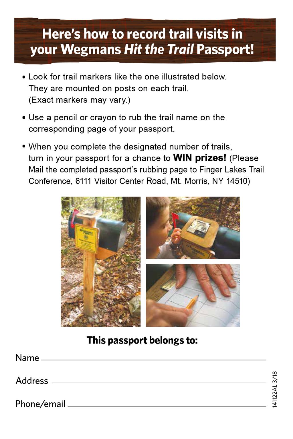
35

36
Passport. to family wellness. from Letchworth to Rt. 81. Adirondack. Park. Catskill Park. New Jersey. Pennsylvania. New York. Allegany State.
 to family wellness Passport from Letchworth to Rt. 81 Co-sponsored by: Long Path Great Eastern Trail North Country Trail Adirondack Park Niagara Falls Canada Buffalo Batavia Letchworth Rochester Canandaigua
beach. Make the ford and follow the trail out to the junction with Red Creek Tr in an open grassy area.
 Description: This is a moderate to slightly strenuous 22.8 mile backpack (add 2.6 miles if you do the packless out and back to the Lion s Head) that will have you exploring nearly every thing that is The
blood pressure know your 5-20 points 8-14 points 4-9 points 2-8 points 2-4 points Hypertension - optimal - pre-hypertension-hypertension
 know your blood pressure Hypertension - optimal - pre-hypertension-hypertension Optimal Less than 120/80 Pre-hypertension 120-139/80-90 Hypertension 140/90 or greater Lifestyle Change Lose weight! For
Marilla Reservoir to Chestnut Ridge via Marilla Trails and Bullis Hollow Trail east to west
 USGS topographic maps useful to this hike are the Bradford and Stickney 7.5 minute sectionals. These notes are designed to assist in identifying distance and location using geophysical and man-made characteristics
C E N T R A L C A T S K I L L S
 120 C E N T R A L C A T S K I L L S Central Catskills Once out of the southern parts of the Catskills, the Long Path enters the more well traveled and civilized regions. The trail joins the Devil s Path,
Stephens State Park Trails
 TRAILS OF ALLAMUCHY MOUNTAIN & STEPHENS STATE PARKS Allamuchy Mountain and Stephens State Parks contain 28 marked trails providing access to diverse landscapes for walking, hiking, biking, bird-watching,
Black Hill Regional Park, Little Seneca Lake
 Black Hill Regional Park, ittle Seneca ake ittle Seneca ake, in Black Hill Regional Park, is a reservoir created after a previous drought struck the Washington area. The park is under Maryland-National
Discover the Finger Lakes Trail EASTERN PORTION (MOSTLY EAST OF I-81) Co-sponsored by:
 Co-sponsored by:") Discover the Finger Lakes Trail EASTERN PORTION (MOSTLY EAST OF I-81) Co-sponsored by: know your blood pressure Hypertension - optimal - pre-hypertension-hypertension Optimal Less than 120/80 Pre-hypertension
Discover the Finger Lakes Trail EASTERN PORTION (MOSTLY EAST OF I-81) Co-sponsored by: know your blood pressure Hypertension - optimal - pre-hypertension-hypertension Optimal Less than 120/80 Pre-hypertension
Tiger Mountain State Forest:
 98 60 hikes within 60 miles: SEATTLE 20 Tiger Mountain State Forest: West Tiger Mountain Three Loop i KEY AT-A-GLANCE INFORMATION Length: 5.1 miles round-trip Configuration: Loop Difficulty: Moderate difficult
Suggested Day Hikes. Mount Greylock State Reservation 3, 4 1, 2. Take a Hike! Things to remember:
 Suggested Day Hikes Mount Greylock State Reservation Take a Hike! This guide offers suggested day hike routes in two parts: 1) Year-round Hikes and 2) Seasonal Hikes (late-may to Nov.1). Use this guide
This Passport: Revised October 20, 2017, EAM # Discovering the Trails of Webster, NY
 This Passport: Revised October 20, 2017, EAM #161923 Discovering the Trails of Webster, NY The Town of Webster invites you to explore and experience our diverse outdoor adventures! Here s your opportunity
AOTA ArtTrek Locations
 AOTA ArtTrek Locations ArtTrek is a summer-long Grand County, CO art adventure. Highlighted by snow-covered mountain vistas and rolling meadows threaded with sparkling streams and rivers, numerous sites
Difficult Run Stream Valley Park
 Difficult Run Stream Valley Park The more intense mountain bikers have known about for Difficult Run for some time. Equestrians have known it longer. Eight miles of unpaved trail, the Rails to River Trail
Leaden Boot Challenge ROUTE INSTRUCTIONS
 Leaden Boot Challenge ROUTE INSTRUCTIONS Section 1 Alstonefield to Ilam From the village hall car park turn R then L and pass through the village keeping to the R to enter Church Street. Pass the Church
This Passport: Revised October 20, 2017, EAM # Discovering the Trails of Penfield, NY
 This Passport: Revised October 20, 2017, EAM #161922 Discovering the Trails of Penfield, NY The Town of Penfield is fortunate to have a wide variety of natural resources which make for many unique and
A Publication of Friends of Sleeping Bear Dunes
 A Publication of Friends of Sleeping Bear Dunes 2014, Friends of Sleeping Bear Dunes, P.O. Box 545, Empire, MI 49630 www.friendsofsleepingbear.org info@friendsofsleepingbear.org Learn more about the Friends
CRAZY HORSE TRAIL GUIDE
 CRAZY HORSE TRAIL GUIDE Abridged Version: July 2016 This is a short form of our interpretive trail guide for the Crazy Horse Trail. The full version of the guide has a more detailed description of the
GIFFORD PINCHOT NATIONAL FOREST
 GIFFORD PINCHOT NATIONAL FOREST 9341 Wright Meadow 93 Spencer Meadow Spencer Butte 4247' 30 30A 19 24 80 31C Lewis River Lower Falls 5 Quartz Creek 90 Taidnapam Falls Upper Falls 31 Spencer Peak 3861'
Telluride-to-Moab Alternative Singletrack Options
 Telluride-to-Moab Alternative Singletrack Options Day 1 Day 1 Alternate 1: Galloping Goose to Deep Creek. 18.4 miles, ascent 3,530ft, descent 1,388ft. This is fun, flowey, moderate to intermediate singletrack
Leaden Boot Challenge 2016 ROUTE INSTRUCTIONS
 Leaden Boot Challenge 2016 ROUTE INSTRUCTIONS Section 1 Alstonefield to Ilam (CP2) From the village hall car park turn R then L and pass through the village keeping to the R to enter Church Street. Pass
Matthiessen State Park Dells Area Hike
 90 Easy Hikes Close to Home At the south end of the hike, you ll climb on top of a mound left over from a former coal-mining operation in the park. Not far from Goose Lake Prairie, the town of Morris hosts
S H A W A N G U N K R I D G E T R A I L
 214 Shawangunk Ridge Trail The Shawangunk Ridge Trail was originally conceived as a relocation of the Long Path from Harriman State Park to Minnewaska State Park. Now part of the Long Path system, the
Beaver Creek State Park
 GENERAL INFORMATION Name of Park/Forest/Facility: Beaver Creek State Park County: Columbiana (St. Clair Township) Address: 12816 Sprucevale Road (ie County Rd 428) (street #, city) East Liverpool, Ohio
Hiking Trail Descriptions
 Hiking Trail Descriptions For ye shall go out with joy. And be led forth with peace. The mountains and the hills shall break forth before you in singing. And all the trees of the fields shall clap their
Other Agencies and Organizations
 Daniel Boone National Forest 1700 Bypass Road WInchester, KY 40391 859-745-3100 Location Northern terminus is near Morehead, Kentucky. Southern terminus is located in the Big South Fork NRRA in Tennessee.
Rogue Gorge (Mt. Stella) Roadless Area-- T30S R3E (primarily in portions of Sections 23, 26, 33, 34 & 35)
 Roadless Area-- T30S R3E (primarily in portions of Sections 23, 26, 33, 34 & 35)") Rogue Gorge (Mt. Stella) Roadless Area-- T30S R3E (primarily in portions of Sections 23, 26, 33, 34 & 35) Rogue River-Siskiyou National Forest--High Cascades Ranger District Upper, higher elevation trail
Rogue Gorge (Mt. Stella) Roadless Area-- T30S R3E (primarily in portions of Sections 23, 26, 33, 34 & 35) Rogue River-Siskiyou National Forest--High Cascades Ranger District Upper, higher elevation trail
Beautiful Walks from the Blue Ball Inn
 Walk No. 5 RIVER VALLEYS AND MOOR Countisbury, Watersmeet, Hillsford Bridge, Cheriton, Shilstone Hill, Rockford and Chiselcombe. 8.5 MILES APPROX. Walking time four and a half hours approx. OS 1;25,000
This Passport: Revised March 20, 2017, EAM # Discover the Trails of Perinton, NY
 This Passport: Revised March 20, 2017, EAM #161921 Discover the Trails of Perinton, NY The Town of Perinton invites you to explore and experience our diverse outdoor adventures! Here s your opportunity
SECTION 1: MARYLAND TO PA nd CROSSING MASON DIXON LINE TO RAINSBURG GAP BUCHANAN STATE FOREST, PRIVATE LAND, SGL 97
 SECTION 1: MARYLAND TO PA 326 2 nd CROSSING MASON DIXON LINE TO RAINSBURG GAP BUCHANAN STATE FOREST, PRIVATE LAND, SGL 97 Web Update, August 2010 http://www.hike mst.org Section 1 follows Tussey Mountain
Crystal Lake Area Trails
 Lake Area Trails Welcome to the Lake area of the Big Snowy Mountains! This island mountain range in central Montana features peaks reaching to 8,600 feet and long, high ridges from which vistas of the
CELEBRATE WEST GREENWICH GEOCACHING THROUGHOUT WEST GREENWICH
 CELEBRATE WEST GREENWICH GEOCACHING THROUGHOUT WEST GREENWICH The West Greenwich Land Trust (WGLT) is sponsoring Celebrate West Greenwich, an event designed to celebrate the beauty and history of scenic
Section 7: Pick Up Where You Left Off! S-Tree Road over the Todd Road
 2018 TRACE NOTES Helpful information for your adventure on Section 7 of the Hiker Challenge. Start Point S-Tree Rd. End Point Intersection Todd Rd. / Hale Ridge Rd. WEATHER DECISION Weather Alert!!!! Potential
Skiing and Snowshoes on Un-groomed Fernan Saddle Terrain
 Skiing and Snowshoes on Un-groomed Fernan Saddle Terrain Three ski or snowshoe routes are available from the Fernan Saddle Parking Lot which either do not cover routes ordinarily groomed for snow machine
Welcome to North Harpersfield NY Pg 1. General Information Directions Map of Property.Lodging.Area Attractions. General Information
 Welcome to North Harpersfield NY Pg 1 General Information Directions Map of Property.Lodging.Area Attractions General Information Welcome to North Harpersfield. George Rand and Pamela Ryder invite Fyke
CWMGIEDD FROM ABERCRAVE
 Abercrave to Cwmgiedd Walk Page 1 Starting from The Abercrave Inn. Grid Ref: SN 824128 From the Abercrave Inn, an 11.3km (7 miles) walk to the foothills of the Cribarth Mountain, then through forest to
BOOK 2. Discover Wayne County Trails. Trail Works, Inc. is a volunteer group dedicated to trail development and use.
 Trail Works, Inc. is a volunteer group dedicated to trail development and use. Your membership in Trail Works insures that healthy programs like this continue to thrive. Join today at www.trailworks.org
Milwaukee River (Washington County) Segment. Kewaskum. Æÿ B. Æÿ D Southern. Kewaskum. Segment.
 Segment. Kewaskum. Æÿ B. Æÿ D Southern. Kewaskum. Segment.") Ice Age Trail Washington County Washington County FOND DU LAC WASHINGTON Æ% 28 Æÿ H Milwaukee River (Washington County) Æÿ B Æÿ S State Forest Northern Kettle Moraine Æÿ H Æ% 28 Ice Age Trail Alliance
Ice Age Trail Washington County Washington County FOND DU LAC WASHINGTON Æ% 28 Æÿ H Milwaukee River (Washington County) Æÿ B Æÿ S State Forest Northern Kettle Moraine Æÿ H Æ% 28 Ice Age Trail Alliance
INTERMEDIATE. mayorsmtbchallenge.org
 mayorsmtbchallenge.org Redding s second local Mountain Bike Challenge uniting current and new bicyclists in a friendly self-competition highlighting our diverse trail system. INTERMEDIATE Mule Ridge Cosmos
UMASS CROSS-COUNTRY Trails
 UMASS CROSS-COUNTRY Trails 1) EGG (43 min) (A) From Cage proceed to North Pleasant street (by campus pond). Make left and head toward LGRT and pass School of Education. Pass Puffton Apt complex (on left)
Best Hikes on Orcas Island
 Published on San Juan Islands Washington Visitors Bureau Orcas Island Lopez Island Friday Harbor San Juan Island (https://www.visitsanjuans.com) Best Hikes on Orcas Island The Emerald Isle offers big trees,
KETTLEBOWL - Distance: Approximately 13 miles Highway 52 to Polar at Highway 64.
 LANGLADE COUNTY ICE AGE NATIONAL SCENIC TRAIL CONDITIONS (As of September 7, 2017) Due to situations beyond the control of the Langlade County Chapter of the Ice Age Trail Alliance, conditions are constantly
Western Commission Track to Dubbo Gully
 This two day walk follows a series of historic roads along clear and wide management trails. This walk explores the great views from Western Commission Track, the sandstone handicraft on the Old Great
GOLDEN EARS PROVINCIAL PARK
 GOLDEN EARS PROVINCIAL PARK Trail Information as of October 10 th 2015 Do not underestimate the mountainous wilderness of Golden Ears Provincial Park. The combination of rugged terrain and rapidly changing
Caledon Hills Bruce Trail Club Discovery Hike Series Badge
 Caledon Hills Bruce Trail Club Discovery Hike Series Badge To earn this Discovery Badge you must complete all the hikes listed below, either on your own or on an organized hike. You will have fun discovering
Trail Beginning Elevation: 7553 ft The Poison Creek Trailhead is located at the end of National Forest Road 646E (NF-646E).
.") West Mountain Trails Poison Creek Trail #134 Length: 2.9 miles (4.7 km) Difficulty Horseback: A good trail for the first time west mountain rider, some steep sections Hiking: Most Difficult USGS Maps:
West Mountain Trails Poison Creek Trail #134 Length: 2.9 miles (4.7 km) Difficulty Horseback: A good trail for the first time west mountain rider, some steep sections Hiking: Most Difficult USGS Maps:
Asheville & WNC Hikes
 Asheville & WNC Hikes Amazingly, we have 3,000+ miles of free public hiking trails near Asheville, including 1,600 miles in the Pisgah and Nantahala National Forests, 850 miles in Great Smokey Mountains
Merritts Traverse. 1928m
 Merritts Traverse 3 hrs Hard track 5.8 km Circuit 4 167m This walk starts with a scenic journey to the top of the hill on the chairlift. Starting along Merritts Nature walk, this walk soon detours down
Southern Utah University Hike Brochure
 Southern Utah University Hike Brochure Taylor Creek Trail Twenty minutes from Cedar City Red Hollow An hour and a half from Cedar City Fees: Entrance fee to Kolb Canyon Length: 5 miles round trip Length:
(/ 12 (/ 18 (/ 18 (/ 12 (/ 51 (/ 14 Æ%106 Æ% 106 Æ% 213 Æ% 104 Æ% 89 Æ% 26 Æ% 73 Æ% 59 Æ% 138 Æ% 92 Æ% 26 Æ% 67 Æ% 11 Æ% 11 Æ% 11. Æÿ H Æÿ Z.
 WAUKESHA Existing Ice Age Trail, subject to change as it evolves toward completion Glacial Drumlin Rail-Trail 94 Ice Age Trail Rock, Walworth and Jefferson Counties Other Trail Unofficial Connecting Route
Piestewa Peak/Dreamy Draw Trail Guide
 Piestewa Peak/Dreamy Draw Trail Guide Trail #1A - Perl Charles Memorial Trail Length: 4.8 miles Elevation: 2,200 ft. - 1,340 ft. Difficulty: Moderate to difficult The Perl Charles trailhead is located
Hike at Pico Blanco Labor Day Weekend!
 Hike at Pico Blanco Labor Day Weekend! The Pico Blanco Hymn Here among the trees majestic Pleasures you will find On the trails of Pico Blanco With your friends and mine Trail the Eagle ever onward This
HIGH POINT STATE PARK
 State of New Jersey, Department of Environmental Protection Division of Parks and Forestry State Park Service njparksandforests.org HIGH POINT STATE PARK TRAILS OF HIGH POINT STATE PARK There are thirteen
Self-Guided Walk Langdale Pikes. Start & Finish: NT car park (free to members) at Sticklebarn - on the right just beyond the New Dungeon Ghyll hotel.
 at Sticklebarn - on the right just beyond the New Dungeon Ghyll hotel.") Self-Guided Walk Langdale Pikes Key Information These mountains form a collection of spires and cliffs on the north side of Langdale. This walk visits four of the main tops Pavey Ark, Harrison Stickle,
Self-Guided Walk Langdale Pikes Key Information These mountains form a collection of spires and cliffs on the north side of Langdale. This walk visits four of the main tops Pavey Ark, Harrison Stickle,
Hiking Waterfalls In New York: A Guide To The State's Best Waterfall Hikes By Randi Minetor
 Hiking Waterfalls In New York: A Guide To The State's Best Waterfall Hikes By Randi Minetor A Guide to the State's Best Waterfall Hikes Randi Minetor Hiking Waterfalls in New York provides driving directions
Camp Geronimo Rainbow Trails
 Camp Geronimo Rainbow Trails With over 5,000 acres of surrounding national forest, the possibilities of getting out and seeing the wilderness are almost limitless. Camp Geronimo offers some of the greatest
To Wellness. To Wellness PASSPORT PASSPORT. Partners. Partners. Ashland County Health & Human Services 630 Sanborn Avenue, Ashland, WI
 Partners Ashland County Health & Human Services 630 Sanborn Avenue, Ashland, WI Ashland Bretting Center 320 4th Avenue W., Ashland, WI PASSPORT Bayfield County Health Department 117 E. 6th Street, Washburn,
See Explorer Camp Brochure/ for Ages Ages 4-9
 www.tinmountain.org See Explorer Camp Brochure/ www.tinmountain.org for Ages 10-16 Ages 4-9 SUMMER CAMP 2011 CELEBRATING 27 YEARS OF SUMMER CAMP FOR CHILDREN AGES 4-16 YEARS Tin Mountain s mission is to
PASSPORT. Discovering the Trails of Webster, NY
 PASSPORT to family wellness Discovering the Trails of Webster, NY Join the Friends of Webster Trails, Webster Health and Education Network, The Town of Webster and Wegmans to get moving more and enjoy
Hiking Las Vegas.com
 Hike: Mt. Wilson via First Creek Canyon route Trailhead: First Creek marked Distance: 10 miles up and back Elevation gain: 3,400 feet Elevation of Peak: 7,070 feet Time: 7 to 9 hours (up and back) Difficulty:
Great Falls National Park, Virginia
 Great Falls National Park, Virginia Despite having grown-up in the area, I had not seen Great Falls until I was near an adult. I used to think places like Great Falls only existed someplace else that you
Listing of Campsites on the Manigotagan River
 Listing of Campsites on the Manigotagan River This document lists and describes the campsites along the Manigotagan River between Highway #314 and the government dock in the community of Manigotagan. The
On The Trail. Twelve Mile Run and Kunes Camp Trail ---splendid solitude! By Gary Thornbloom
 On The Trail Twelve Mile Run and Kunes Camp Trail ---splendid solitude! By Gary Thornbloom Twelve Mile Run is about as isolated as you can get in the Quehanna Wild Area. You will find solitude and silence
Camp Jack Wright PERMANENT ORIENTEERING COURSE (2004)
") Camp Jack Wright PERMANENT ORIENTEERING COURSE (2004) WHAT IS ORIENTEERING? The skill which enables a person to navigate with a map. In the competitive sport, the winner is the person who finishes in the
Camp Jack Wright PERMANENT ORIENTEERING COURSE (2004) WHAT IS ORIENTEERING? The skill which enables a person to navigate with a map. In the competitive sport, the winner is the person who finishes in the
The Mendip Way. Route Directions and Maps Uphill to Wells
 The Mendip Way Route Directions and Maps Uphill to Wells Website: www.mendiphillsaonb.org.uk Email: mendip@mendiphillsaonb.org.uk Facebook & Twitter: @MendipHillsAONB Phone: 01761462338 1 Uphill to Loxton
ASRA 2018 Hike Schedule
 ASRA 2018 Hike Schedule Date/Day Destination Hike Info Meeting Info Leader Feb 10, Saturday Stagecoach and 9:00 at the Confluence kiosk. Manzanita trails Parking fee required. We ll hike along the trail
The gorges of Mohican Park in Ohio create a hiker's paradise Sunday, May 22, 2011 By Bob Downing, Akron Beacon Journal
 Pittsburgh Post-Gazette The gorges of Mohican Park in Ohio create a hiker's paradise Sunday, May 22, 2011 By Bob Downing, Akron Beacon Journal Bob Downing Big Lyons Falls drops 80 feet into a shady U-shaped
National Recreation Trail Application for Designation
 National Recreation Trail Application for Designation Introduction Thank you for your interest in the National Recreation Trail (NRT) program. Completed NRT application packages must be submitted by December
H U D S O N P A L I S A D E S
 14 H U D S O N P A L I S A D E S Hudson Palisades The southernmost sections of the Long Path follow the Hudson River and the Hudson Palisades north, staying close to the river and to civilization. Although
Androscoggin River Trail Access Sites. North Woods. 168 miles from its source at Lake Umbagog to Merrymeeting Bay
 Androscoggin River Trail Access Sites North Woods 168 miles from its source at Lake Umbagog to Merrymeeting Bay Trail Under Construction More than 40 Public Access Sites Available Androscoggin River Watershed
Kitimat. Pacific Inland Coast. Hiking Guide Kitimat, British Columbia, Canada
 Kitimat Pacific Inland Coast Hiking Guide Kitimat, British Columbia, Canada 2010-2011 Sites and Trails Emergency Call 911 Police - Fire - Medical 2 Welcome to Kitimat This information was produced to assist
Location: Height: Access: Distance: Elevation: Season: Difficulty: Lat/Long: Directions:
 Upper Eagle Falls Upper Eagle Falls (~20 ft.) is a short hike up from the roadside at the Eagle Falls picnic area. It is very difficult to get a parking spot here during the day, so it is recommended to
Arches of the. Sandflats Area. By Virginia Allen
 Arches of the Sandflats Area By Virginia Allen TABLE OF CONTENTS Introduction Dedication Road Log Arches 1. Perforated View Arch 2. Fee Booth Arch 3. Windsong Arch 4. Weird Arch 5. Resting Arch 6. Bike
Explore your Town With The Kingston Area Trail Passport
 Explore your Town With The Kingston Area Trail Passport Don t forget to stop at the children's room in the library for your prize when you collect 5 Passport Stamps! For more natural resource related information,
CIEC 9 PEAKS AWARD SUPPLEMENT POSSIBLE ROUTES FOR THE 9 PEAKS AWARD TRIP
 CIEC 9 PEAKS AWARD SUPPLEMENT POSSIBLE ROUTES FOR THE 9 PEAKS AWARD TRIP As you plan your trip, be aware of 3 regulations in this wilderness: 1. Camp only in designated campsites. 2. No campfires allowed.
Rock Creek Park, MD - Lake Needwood
 ock Creek Park, MD - Lake Needwood Lake Needwood, is a reservoir located at the end of the north end of the ock Creek hiker-biker trail. At the other end, ock Creek empties into the Potomac iver near Thompson
A DESERT CAMPING GUIDE FOR ANZA BORREGO DESERT STATE PARK
 A DESERT CAMPING GUIDE FOR ANZA BORREGO DESERT STATE PARK With over 500,000 acres of beautiful terrain, Anza Borrego Desert State Park offers endless opportunities for Boy Scout Troops, Venture Crews and
LANGLADE COUNTY ICE AGE NATIONAL SCENIC TRAIL CONDITIONS (As of May 18, 2017)
") LANGLADE COUNTY ICE AGE NATIONAL SCENIC TRAIL CONDITIONS (As of May 18, 2017) Due to situations beyond the control of the Langlade County Chapter of the Ice Age Trail Alliance, conditions are constantly
LANGLADE COUNTY ICE AGE NATIONAL SCENIC TRAIL CONDITIONS (As of May 18, 2017) Due to situations beyond the control of the Langlade County Chapter of the Ice Age Trail Alliance, conditions are constantly
Greenbush Town Hall / Fire Station
 Page 1 of 18 Course Description Greenbush Town Hall / Fire Station Both races start in front of the Greenbush Town Hall / Fire Station, just south of Highway 23 on Sugarbush Road. Parking will be in the
Topsham Trail Guide.
 Topsham Trail Guide A guide to the walking, hiking, biking, water and ATV trails of Topsham, Maine and surrounding towns $4.95 Developed by the www.greatertopshamtrailalliance.org The Greater Topsham Trail
43 STONE MOUNTAIN LOOP
 204 60 hikes within 60 miles: atlanta 43 STONE MOUNTAIN LOO i KEY AT-A-GLANCE INFORMATION LENGTH: 5.5 miles CONFIGURATION: Loop DIFFICULTY: Easy SCENERY: Views of Stone Mountain and Confederate Memorial;
HIKING/BIKING IN MERRITT AREA
 HIKING/BIKING IN MERRITT AREA Coquihalla Lakes: Just inside the southern boundary of BC Park's Coquihalla Summit Park, a nice little twin lakes paddle with a private campground & lodge is the Coquihalla
National Recreation Trail Update Form
 National Recreation Trail Update Form Introduction Thank you for taking the time to complete this form. Your assistance will help ensure that the National Recreation Trail (NRT) database is complete and
Lake Wissota Access Locations within the LaFayette Township. By Chad Martin
 Lake Wissota Access Locations within the LaFayette Township By Chad Martin Anson/ Wissota Access Point # 1 Road: 195 th St. Associated Fire Numbers: 13294 Defining Characteristics: Forested from road
Anderson Mt. Proposed Wilderness Additions to the Rogue-Umpqua Divide Wilderness-- T30S R3E (mostly) Sections 4 & 9, and T29S R3E Section 33
 Sections 4 & 9, and T29S R3E Section 33") Anderson Mt. Proposed Wilderness Additions to the Rogue-Umpqua Divide Wilderness-- T30S R3E (mostly) Sections 4 & 9, and T29S R3E Section 33 When the 35,701 acre Rogue-Umpqua Divide Wilderness was designated
Anderson Mt. Proposed Wilderness Additions to the Rogue-Umpqua Divide Wilderness-- T30S R3E (mostly) Sections 4 & 9, and T29S R3E Section 33 When the 35,701 acre Rogue-Umpqua Divide Wilderness was designated
Brinker Creek Ranch. Colorado - Routt County - Yampa
 Located at the base of the Flattops Range in the Steamboat/Vail corridor, Brinker Creek Ranch consists of 1,451 acres ideally suited for high country grazing and native grass hay production. Traditionally
Trail Notes Palouse Region Hikes
 Trail Notes Palouse Region Hikes Campus Recreation 875 Perimeter Drive MS 1230 Moscow, Idaho 83844-1230 Ph: 208.885.6810 Rentals: 208.885.6170 Fax: 208.885.6879 uidaho.edu/outdoorprogram 0 PALOUSE REGION
Cincinnati Nature Center s
 120 60 hikes within 60 miles: cincinnati 24 Cincinnati Nature Center s Rowe Woods i KEY AT-A-GLANCE INFORMATION Length: 8.9 miles Configuration: Loop Difficulty: Difficult Scenery: Forest, ponds, prairie,
West Trails Trek Guide. Chief Pontiac Trail Credential Hikes
 West Trails Trek Guide Kensington Start Edition Chief Pontiac Trail Credential Hikes RDS.WTW.110609 WP# Dist. Accum. Dist. Accum. Feet Miles Meters Meters 1 0 0.0 0 0 2 410 0.1 125 125 3 164 0.1 150 275
Griffith Park Trail Run Trail Guide Click for
 The Griffith Park Trail Run by Hike- LosAngeles.com Griffith Park Trail Run Trail Guide Click for downloadable cell phone guide and map from EveryTrail. DISTANCE: 4.55 Miles ELEVATION: 1280' ELEVATION
Lava Mountain Trail Distance: Elevation Range: Trail Type: Difficulty: Season: Driving Distance: Driving Time: USGS Maps: Pros Cons
 Lava Mountain Trail Distance: 13.4 miles (including the side trip to North Star Lake) Elevation Range: 5900'-8330' Trail Type: singletrack Difficulty: moderate Season: late June-October Driving Distance:
Region 7 Western Panhandle Apalachicola River to Deer Lake Junction
 Region 7 Western Panhandle Apalachicola River to Deer Lake Junction Description Dist S-N Wypt N-S Cross Apalachicola River on SR 20 bridge. 1.5 0.0 8-2 175.4 Eastern/Central Time Zone change. Pass restaurant
Trail Phasing Plan. Note: Trails in the Clear Creek Canyon area (Segments will be finalized in the future to minimize wildlife impacts
 Note: Trails in the Clear Creek Canyon area (Segments 2 5 and a future JCOS connection) will be finalized in the future to minimize wildlife impacts Trail Phasing Plan P Parking 3 Easy Trail Intermediate
throu Booth Hill Green Belt
 s k r a p s l l u b m u r T Explore gh Geocaching throu Booth Hill Green Belt This was originally a concept to try and preserve some of the land in our town, without hurting the developers that are creating
Walk 1. Cotswold Water Park. Gateway Centre to Cerney Wick, railway track to Lake 6, Gateway Centre.
 Cotswold Water ark Walk way A Swindon/ Cirencester Thomas and Severn Canal way to Cerney Wick, railway track to Lake, way. Spine Road East Hotel Time: hours (short walk km) Distance: km A level walk along
Description Dist S-N Wypt N-S Region 7 Western Panhandle Apalachicola River to Deer Lake Junction
 Region 7 Western Panhandle Apalachicola River to Deer Lake Junction Description Dist S-N Wypt N-S Cross Apalachicola River on SR 20 bridge. 1.5 0.0 8-2 175.4 Eastern/Central Time Zone change. Pass restaurant
2019 DAY HIKE AT IRON MOUNTAIN SATURDAY, JANUARY 19
 WHERE? In Google Maps, paste the following coordinates for Iron Mountain: 32.978215,-116.972593 or CLICK ON THIS LINK. I. Purpose of the Day Hike A. THE WBC Day Hike is a relatively short trail hike to
BRYCE CANYON COUNTRY Boulder Mountain Scenic backways itinerary
 BRYCE CANYON COUNTRY Boulder Mountain Scenic backways itinerary Boulder Mountain Area The high plateaus of the Aquarius Plateau (Boulder Mountain), are heavily forested and covered in countless winding
Cleveland Photographic Society Amish Country Field Trip Saturday, August 15, 2015
 Cleveland Photographic Society Amish Country Field Trip Saturday, August 15, 2015 Trip Coordinator: Rob Erick 440-570-3352 Feel free to call or text along the way with any questions This trip is planned
Cataloochee. Fishing Species Rainbow Trout and Brook Trout. Recreation
 Cataloochee River Information The Cataloochee River is located in the historic Cataloochee Valley--a relatively remote part of Smoky Mountain National Park. The campground is a secluded setting and offers
Embrace New York s Finger Lakes Area Sun-Sat, Oct & Oct , 2017
 Embrace New York s Finger Lakes Area Sun-Sat, Oct. 15-21 & Oct. 22-28, 2017 According to Native American legend, the Great Spirit laid his hands on this land to bless it, leaving imprints of his fingers,