Stakeholder Engagement Session Report Motorized Trail Users Evergreen TEC Centre April 27,, 2010
|
|
|
- Noreen York
- 5 years ago
- Views:
Transcription

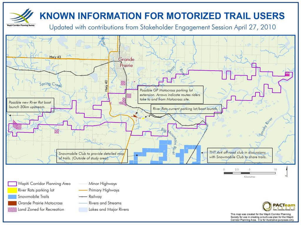
1 Avenue Clairmont, AB T0H 0W0 Tel Web site: Stakeholder Engagement Session Report Motorized Trail Users Evergreen TEC Centre April 27,, 2010 Introduction The Wapiti River Valley corridor, which extends from Pipestone Creek to the Smoky River, is a beautiful natural area used for recreational, agricultural, industrial, educational and ecological purposes. With the growth in population, this area is seeing increasing activity; therefore it is important that the local community and resource users (stakeholders) take steps to ensure that the best decisions are made about how the area is used, now and in the future, to ensure the safety, security and benefit for everyone. The Wapiti Corridor Planning Society (WCPS) is creating- through an open, transparent and inclusive process- a vision and multi-use land use plan for the Wapiti River Valley corridor that accommodates, protects, and balances the current and future needs of the area and its people. As such the WCPS is working with stakeholders to cooperatively develop a set of recommendations and implementation actions to guide the use and development of the Wapiti River Valley corridor. The ultimate goal is to develop a multi-use plan that meets the needs of all land users. On April 27, 2010 the WCPS held a stakeholder engagement session with motorized trail users of the Wapiti River Valley. The Society invited representatives from organized quading, motocross riding, power boat driving and other off-road user groups to a session aimed at contributing to the development of the multi-use plan for the Wapiti River Valley corridor. During the session a map with current state of knowledge about Motorized Trails was used to validate and document new information. The session focused on uses of the area; the concerns users have over how the area is used; and their vision for the future of the area. The session started at 06:50 p.m. and ended at 09:00 p.m. 1
2 In Attend A ttendance ance: Bob Scott Christine Schlief Dan Wong David Pochailo Jim Smith Ken Langstaff Lauranie Howatt Lesley VanDemark Lou Maffret Mike Brekkans Randy Gulick Rick Bennett Wade Bloomer Barry Hunter Carlos Salinas Camp Wapiti Board Trustee; Wapiti Peace School WCPS, City of Grande Prairie Public Lands Officer; SRD President; WCPS Evergreen Park Board; WCPS Treasurer, WCPS; Wapiti Dunes Development Society (WDDS) Councillor, MD Greenview; WCPS President, Grande Prairie Moto Cross Association; WCPS Trapper Grande Prairie River Rats Swan City Snowmobile Club Wapiti Dunes Development Society (WDDS); WCPS Planning Consultant to WCPS Planning Consultant to WCPS 1. Concerns and Challenges There are no guidelines or direction on how to use the trails right now. The quads and ATVs are taking over all the sand dunes from border to border, both sides. There is a large number of riders under 16 years of age. Enforcement of underage riders should start from the city. RCMP and county officers should be patrolling in the dunes area. Significant damage to forests by pine beetles and fires. No identified representation from the quad riders group to be included in the board. Quad manufacturers and dealers may help to create these groups as they are approached by these users. 2. Land Use Priorities and Strategies There must be respect to all users: horseback riders, hikers, etc. The use of sand dunes should be accessible again to horse riders and hikers as with was in the past. Designate suitable areas for horseback riders and hikers, for example, areas west to Highway 40. There should be trail signage for direction and safety warning messages. In addition, education campaigns for the use of a trail system. Due to the magnitude of easy-access related problems, fencing should be brought up as a solution for some of the users needs (i.e. trappers, parks). 2
3 A boat launch should be constructed on the East side of Highway 40 bridge. Likewise, the River Rats Club would like to have a river boat launch 30 miles upstream from Pipestone. Signage, education and enforcement activities should be implemented as part of the strategies of the plan. Invitation to enforcement groups to inform about the WCPS and to see what their enforcement plans are. Waste disposal and garbage on the river valley: Dumpsters should be installed in staging areas. Areas east to Resources Road should be designated for quad riders and areas west to Highway 40 for horseback riders and hikers. Controlled access of quad riders to all trails and areas can be done by setting better staging areas. The existing motocross track and future 50 cc tracks are to be included in the WCPS plan. Rather than point fingers to unorganized groups, encourage them to participate and help to manage the area. Keeping doors open for participation to all users, even to unorganized users, and create as many opportunities as we can for participation. Exploring bikers: Not a big concern. They have low impact on environment. 3. Management Areas Recreational Areas: o Trail system for motorized users in the eastern side should be designed for different users; these can be multi trail or single trail systems according to the users. o Area east of the bridge can be converted by SRD into a big grass area for people to use. Protected Areas: o Areas with ecological value: swamps. o Some trapping lines may be preserved at the end of leasing period. o There are closed facilities to off road riders in the area (winter range areas). Industrial Development: o It is important to ensure that residential development in the river valley does not affect the recreational value that the wapiti river valley corridor represents for the people of Grande Prairie. 3

4 4. Organized Groups, Mission Statements and Codes of Conduct Motorized user organizations have mission statements, codes of conduct which consider the sharing of trails with other users. The quad problem is not a problem restricted to Grande Prairie. The Province of Alberta is trying to come up with some guidelines, it is one of the priority subjects under the land use framework, it seems that nobody from the meeting was involved in the development of those ALUF guidelines. 5. Long Term Goals and Vision There is a motocross track and there are plans to set some more tracks for the use of 50 cc motorbike racers, basically for kids on an adjacent 18 acre parcel. Appropriate trails to allow various users to enjoy their sport safely. 6. Other Issues There are no organized groups of quad riders, except for one called TNT, which comprises small off-road vehicles. Western side of planning area is not so appealing to off-road drivers as most of it does comprise private lands. What size of loop can be a reasonable ride for a horseback riders and/or for a motorized off road vehicle? Off-road traffic nearby traplines directly and negatively affects the trappers activities. 4
5 5
Land Management Summary
 photo credit: ANGAIR Anglesea Heath Land Management Summary The Anglesea Heath (6,501 ha) was incorporated into the Great Otway National Park in January 2018. This provides an opportunity to consider the
Tabor Mountain Recreation Society Who We Are What We Do Regional Park The Ask. Photo by Ken Hodges
 Tabor Mountain Recreation Society Who We Are What We Do Regional Park The Ask Photo by Ken Hodges 1 TMRS History 1961 logging and the Grove Fire activities resulted in many of the existing trails 1961
BACKCOUNTRY TRAIL FLOOD REHABILITATION PROGRAM
 BACKCOUNTRY TRAIL FLOOD REHABILITATION PROGRAM Backcountry Trail Flood Rehabilitation A June 2013 Flood Recovery Program Summary In June 2013, parts of Southern Alberta were devastated from significant
Table of Contents. page 3 Long term Goals Project Scope Project History. 4 User Groups Defined Trail Representative Committee. 5 Trail Users Breakdown
 Launched April 27th, 2010 1 Table of Contents page 3 Long term Goals Project Scope Project History 4 User Groups Defined Trail Representative Committee 5 Trail Users Breakdown 13 Trail Users Desires 16
As outlined in the Tatshenshini-Alsek Park Management Agreement, park management will:
 Management Strategy General Strategy The priority management focus for the park is to ensure that its internationally significant natural, cultural heritage and recreational values are protected and that
PROPOSAL FOR RECLASSIFICATION, BOUNDARY AMENDMENT AND DRAFT CONCEPT PLAN FOR SASKATOON MOUNTAIN NATURAL AREA. Frequently Asked Questions
 PROPOSAL FOR RECLASSIFICATION, BOUNDARY AMENDMENT AND DRAFT CONCEPT PLAN FOR SASKATOON MOUNTAIN NATURAL AREA 1. Why is this proposal being put forward? Frequently Asked Questions For many years, Alberta
STONE MOUNTAIN PROVINCIAL PARK Purpose Statement and Zoning Plan
 1 STONE MOUNTAIN PROVINCIAL PARK Purpose Statement and Zoning Plan Stone Mountain Provincial Park is situated 140 km west of Fort Nelson at Kilometre 595 of the Alaska Highway. The 25 690 ha park is located
FINAL TESTIMONY 1 COMMITTEE ON RESOURCES UNITED STATES HOUSE OF REPRESENTATIVES. July 13, 2005 CONCERNING. Motorized Recreational Use of Federal Lands
 FINAL TESTIMONY 1 STATEMENT OF DALE BOSWORTH CHIEF Of the FOREST SERVICE UNITED STATES DEPARTMENT OF AGRICULTURE Before the SUBCOMMITTEE ON FORESTS AND FOREST HEALTH And the SUBCOMMITTEE ON NATIONAL PARKS,
APPENDIX. Alberta Land Stewardship Act AMENDMENTS TO THE SOUTH SASKATCHEWAN REGIONAL PLAN
 APPENDIX Alberta Land Stewardship Act AMENDMENTS TO THE SOUTH SASKATCHEWAN REGIONAL PLAN 1 All references to Alberta Environment and Sustainable Resource Development, Environment and Sustainable Resource
Preferred Recreation Recommendations Stemilt-Squilchuck Recreation Plan March 2018
 Preferred Recreation Recommendations Stemilt-Squilchuck Recreation Plan March 2018 Below are the recommended recreation ideas and strategies that package together the various recreation concepts compiled
Boyne Valley Provincial Park. Interim Management Statement
 Boyne Valley Provincial Park Interim Management Statement January 20, 1995 REGIONAL DIRECTOR'S APPROVAL STATEMENT This Interim Management Statement will provide interim direction for the management of
Attendance Presentation
 TO The Community of Saanich FROM District of Saanich DATE January 30, 2017 RE Meeting Notes Haro Woods Jan 28th Community Engagement Goward House, 2495 Arbutus Road, Victoria BC Attendance In total, 18
Marchand Provincial Park. Management Plan
 Marchand Provincial Park Management Plan 2 Marchand Provincial Park Table of Contents 1. Introduction... 3 2. Park History... 3 3. Park Attributes... 4 3.1 Natural... 4 3.2 Recreational... 4 3.3 Additional
CHAPTER 5. Chapter 5 Recreation Element
 CHAPTER 5 Recreation Element Chapter 5 Recreation Element The Recreation Element of the Meyers Area Plan is a supplement to the Recreation Element of the TRPA Regional Plan and the El Dorado County General
Paiute Trail Hatfield-McCoy Highwood Mountains
 Paiute Trail Hatfield-McCoy Highwood Mountains Located in Central Utah Main trail is 238 miles 550 miles of designated side trails Links 16 communities in 4 counties Ranges from 5,200 to 11,500 feet Great
Strengthening the Ontario Trails Strategy. Report on Consultations and the Environmental Bill of Rights Registry
 Strengthening the Ontario Trails Strategy Report on Consultations and the Environmental Bill of Rights Registry Purpose To report on the feedback and information received through the regional consultations,
112th CONGRESS. 1st Session H. R. 113 IN THE HOUSE OF REPRESENTATIVES
 HR 113 IH 112th CONGRESS 1st Session H. R. 113 To provide for additions to the Cucamonga and Sheep Mountain Wilderness Areas in the Angeles and San Bernardino National Forests and the protection of existing
2. Goals and Policies. The following are the adopted Parks and Trails Goals for Stillwater Township:
 D. PARKS AND TRAILS 1. Introduction Stillwater Township s population is relatively low, with most residents living on rural residences on large lots. The need for active park space has been minimal in
Recreation in the Battle River Basin: Overview. John Thompson, Watrecon Consulting
 Recreation in the Battle River Basin: Overview John Thompson, Watrecon Consulting Recreation Rates for Alberta & Battle Basin Households 1996 2004 Battle Basin Alberta Battle Basin Alberta Bird Watching
Committee. Presentation Outline
 CW-33-15 11/9/2015 Community and Corporate Services Committee November 10, 2015 1 Presentation Outline Background Vision and Objectives Study Process and Timeline Public and Stakeholder Engagement Organization
Pillar Park. Management Plan
 Pillar Park Management Plan January 2014 Pillar Park Management Plan Approved by: Jeff Leahy Regional Director Thompson Cariboo Region BC Parks January 9, 2014 Date Brian Bawtinheimer Executive Director
Welcome and thank you for being here! Kick-Off Public Workshop November 19, 2014
 Welcome and thank you for being here! Kick-Off Public Workshop November 19, 2014 OPEN SPACE MATTERS: Boise s First Reserve Master Plan Julia Grant Foothills and Open Space Manager City of Boise Ellen Campfield
Rogue River Access and Management Plan Draft Alternatives
 Rogue River Access and Management Plan Draft Alternatives The Rogue River Access and Management Plan was initiated in December, 2011 and is being led by Jackson County Parks (JCP) and Oregon Department
S Central Coast Heritage Protection Act APRIL 21, 2016
 STATEMENT OF GLENN CASAMASSA ASSOCIATE DEPUTY CHIEF, NATIONAL FOREST SYSTEM U.S. FOREST SERVICE U.S. DEPARTMENT OF AGRICULTURE BEFORE THE UNITED STATES SENATE COMMITTEE ON ENERGY AND NATURAL RESOURCES
MANAGEMENT DIRECTION STATEMENT
 Skeena District MAAGEMET DIRECTIO STATEMET August 2000 for Driftwood Extension to Babine Mountains Park Ministry of Environment Lands and Parks BC Parks Division This management direction statement was
Wyoming Public Lands Initiative in Carbon County
 Wyoming Public Lands Initiative in Carbon County THE CARBON COUNTY WPLI ADVISORY COMMIT TEE WANTS YOUR INPUT Wilderness Study Area: A special designation that applies to lands managed to protect wilderness
Hiawatha National Forest St. Ignace Ranger District. File Code: 1950 Date: August 5, 2011
 United States Department of Agriculture Forest Service Hiawatha National Forest St. Ignace Ranger District W1900 West US-2 St. Ignace, MI 49781 906-643-7900 File Code: 1950 Date: August 5, 2011 Dear National
MANAGEMENT DIRECTION STATEMENT June, 1999
 Thompson River District MANAGEMENT DIRECTION STATEMENT June, 1999 for Roche Lake Provincial Park Ministry of Environment Lands and Parks BC Parks Division Table of Contents I. Introduction A. Setting
Steps in the Management Planning Process
 Steps in the Management Planning Process Developing a management plan for Kalamalka Lake Park will follow a multi-stage process. The planning process for this park is currently in the Draft Management
Blueways: Rivers, lakes, or streams with public access for recreation that includes fishing, nature observation, and opportunities for boating.
 Parks, Open Space and Trails PRINCE WILLIAM COUNTY 2008 COMPREHENSIVE PLAN TRAILS PLAN CONTENTS The components of the trails plan are: Intent Definitions Goals, Policies, and Action Strategies Trails Map
Use of the Rail Corridor as Trail - Report #17/10/17/1102 Deferred from April AMENDED
 Request for Decision Meeting Date Decision Required Direction United Townships of Head, Clara & Maria Council Type of Decision Tuesday, October 17, 2017 X Yes No X Information Only Report Date Priority
Approval Statement. Brian Pfrimmer, Central Zone Manager Ontario Parks
 Approval Statement I am pleased to approve this Interim Management Statement for Dividing Lake Provincial Nature Reserve. This Nature Reserve contains biological features of provincial significance and
Wallace Falls State Park Classification and Management Planning Stage 3 Preliminary Recommendations July 18, 2018 Sultan City Hall
 Wallace Falls State Park Classification and Management Planning Stage 3 Preliminary Recommendations July 18, 2018 Sultan City Hall Thanks for coming! This document contains State Parks preliminary recommendations
Prior to contacting the Whitecourt Trailblazers Snowmobile Club, applicants must:
 WHITECOURT TRAILBLAZERS Box 607 Whitecourt, AB T7S 1N7 www.whitecourttrailblazers.ca CNT AMENDMENT Restriction Code 710: See Comments Comments All applicants are required to contact: Whitecourt Trailblazers
TRAILS WHERE TO FIND TRAILS IN NOVA SCOTIA
 TRAILs SIGNAGE Know the Signs............................ 44 WHERE YOU CAN RIDE Roads and Highways........................ 46 Designated Trails........................... 47 Established Trails...........................
DRAFT - APRIL 13, 2007 ROUTING STUDY FOR TRAIL CONNECTIONS BETWEEN CALAIS AND AYERS JUNCTION
 DRAFT - APRIL 13, 2007 ROUTING STUDY FOR TRAIL CONNECTIONS BETWEEN CALAIS AND AYERS JUNCTION Abstract The vision for the East Coast Greenway is an off-road urban trail system running from Calais, Maine
MANAGEMENT DIRECTION STATEMENT June, 1999
 Thompson River District MANAGEMENT DIRECTION STATEMENT June, 1999 for Clearwater River Corridor (Addition to Wells Gray Park) Ministry of Environment Lands and Parks BC Parks Division ii Table of Contents
RATTLESNAKE HILL PHILLIPS, HARRIS FARM, LIME KILN & QUARRY
 Town of, MA Trails Map 6a SPLIT ROCK PRIMARY SECONDARY PRIVATE PRIVATE PROPERY STAY ON HEAD FUTURE TO SKINNER (NOT MARKED) 0 miles 0.25 0.250 0.5 Mapbox, Data Odbl, OpenStreetMap contributors primary use
BOAT DOCKS AND LAUNCHES. Public Engagement Report July 2015
 BOAT DOCKS AND LAUNCHES Public Engagement Report July 2015 TABLE OF CONTENTS BACKGROUND 3 STAKEHOLDER CONSULTATION 6 PARTICIPANT PROFILE 7 RESPONSE THEMES 8 CONCLUSION 16 BACKGROUND The North Saskatchewan
MANAGEMENT DIRECTION STATEMENT
 Skeena District MAAGEMET DIRECTIO STATEMET July, 2000 for Driftwood Canyon Provincial Park Ministry of Environment Lands and Parks BC Parks Division i Table of Contents Driftwood Canyon Park Approvals
Gold Coast. Rapid Transit. Chapter twelve Social impact. Chapter content
 Gold Coast Rapid Transit Chapter twelve Social impact Chapter content Social impact assessment process...235 Existing community profile...237 Consultation...238 Social impacts and mitigation strategies...239
COUNCIL REPORT Meeting Date: December 10, 2013
 Subject: Highway 63/881 Corridor Area Structure Plan Amendment Bylaw No. 13/037 APPROVALS: Felice Mazzoni, Director Henry Hunter, Executive Director Glen Laubenstein, Chief Administrative Officer COUNCIL
Media Release For Immediate Release Tuesday, April 17, 2018
 Media Release For Immediate Release Tuesday, April 17, 2018 2018 Budget focuses on enhancements to roads and infrastructure Investing in roads and infrastructure is a priority for the County s 2018 budget.
The following trails completed their work utilizing funds awarded by the Greenways Foundation:
 The Greenways Foundation Grant Awards 2013 and 2014 Our grant program has been in place since 2012 and is funded entirely by the proceeds received through our Indiana BMV specialty license plate. Please
A BOAT RAMP TO NOWHERE
 A BOAT RAMP TO NOWHERE A PROPOSAL FOR ACCESS TO HARVIE PASSAGE A Presentation to the City of Calgary December 2017 Presented by: Peter Crowe-Swords Bow River Trout Foundation Background: The Bow River
Visitor s Survey Summary for the Pismo State Beach and Oceano Dunes State Vehicular Recreation Area Public Works Plan and Environmental Impact Report
 January 2019 Visitor s Survey Summary for the Pismo State Beach and Oceano Dunes State Vehicular Recreation Area Public Works Plan and Environmental Impact Report Prepared for: California Department of
Section 3.6 Recreation
 3.6 RECREATION This section evaluates the potential impacts of the proposed project on recreation within MTRP. The evaluation is based on field observations, a review of maps of MTRP and the MTRP Master
Public Review on Proposed Changes to Trapping Policy
 Public Review on Proposed Changes to Trapping Policy in Manitoba s Provincial Parks and Other Crown Lands With Recreational Developments In December 2012, two dogs were killed in traps while they were
ONE ISLAND LAKE PROVINCIAL PARK Purpose Statement and Zoning Plan
 ONE ISLAND LAKE PROVINCIAL PARK Purpose Statement and Zoning Plan Primary Role The primary role of One Island Lake Provincial Park is to provide recreational opportunities to regional and residential area
Priscilla Davenport, Saluda District
 AT A MEETING OF THE MIDDLESEX COUNTY PLANNING COMMISSION HELD ON THURSDAY, NOVEMBER 13, 2003, IN THE PUBLIC MEETING ROOM OF THE COOK S CORNER OFFICE COMPLEX, COOK S CORNER, VIRGINIA. Present: Absent: John
NAPAIMUTE TRIBAL SAFETY PLAN Tribal Transportation Program
 Adopted and Approved April 30, 2015 Amended August 2016 NAPAIMUTE TRIBAL SAFETY PLAN Tribal Transportation Program Native Village of Napaimute Napaimute Traditional Council INTRODUCTION The Native Village
MASTER PLAN EXECUTIVE SUMMARY
 Biscuit Run State Park Scottsville Road (State Route 20) Charlottesville, VA 22902 Biscuit Run State Park MASTER PLAN EXECUTIVE SUMMARY Department of Conservation and Recreation Division of Planning and
Emily to Blind Lake Trail PROPOSED TRAIL DEVELOPMENT APPLICATION SUMMARY
 Emily to Blind Lake Trail PROPOSED TRAIL DEVELOPMENT APPLICATION SUMMARY Township 137 Range 26 (Fairfield Township) sections 2 & 3 Township 138 Range 26 (City of Emily) sections 27, 34, 35, & 36 Township
The Problem. The Problem. The Sylvan Lake Management Committee
 Partners: Town of Sylvan Lake Lacombe County Red Deer County Alberta Environment and Water Alberta Sustainable Resource Development Summer Village of Birchcliff Summer Village of Half Moon Bay Summer Village
Court Ordered Sale ASKING PRICE 2,950,000. DISTRICT LOT 4501 WESTSIDE ROAD 279 ACRES, LAKE OKANAGAN WATERFRONT Central Okanagan Regional District
 Court Ordered Sale DISTRICT LOT 4501 WESTSIDE ROAD 279 ACRES, LAKE OKANAGAN WATERFRONT Central Okanagan Regional District ASKING PRICE 2,950,000 For more information please contact: Brian Tattrie Vice
Public Comment. Comment To consider extending State Park lands above River Mile 7.0
 Public To consider extending Park lands above River Mile 7.0 on the Little Spokane River for the conservation and limited recreation qualities they contain is this request. Could this be included in your
PROUDLY BRINGING YOU CANADA AT ITS BEST. Management Planning Program NEWSLETTER #1 OCTOBER, 2000
 PROUDLY BRINGING YOU CANADA AT ITS BEST VUNTUT NATIONAL PARK Management Planning Program NEWSLETTER #1 OCTOBER, 2000 INTRODUCTION This newsletter launches the development of the first management plan for
Port Bruce. Interim Management Statement
 Port Bruce Interim Management Statement Port Bruce Interim Management Statement August 3, 1999 This Port Bruce Provincial Park Interim Management Statement provides direction for the custodial management
Fédération Québécoise des Clubs Quads. Danny Gagnon General manager (FQCQ)
") Fédération Québécoise des Clubs Quads Danny Gagnon General manager (FQCQ) Mission and objectives Our organism was created in 1985, by a group on ATV riders, and was sponsored, at the time, by the AMMQ
Fédération Québécoise des Clubs Quads Danny Gagnon General manager (FQCQ) Mission and objectives Our organism was created in 1985, by a group on ATV riders, and was sponsored, at the time, by the AMMQ
PURPOSE AND NEED. Introduction
 Public Scoping: Allocation of Recreation Capacity for Commercial Outfitter Guide Services on North Kruzof Island Trails (Kruzof Island Outfitter Guide) PURPOSE AND NEED Introduction The U.S. Department
March 14, SUBJECT: Public input to the Bureau of Land Management, Gunnison Field Office, Travel Management Plan
 March 14, 2019 Delivered via email to ewaters@blm.gov Elijah Waters Field Manager BLM Gunnison Field Office Gunnison, CO 81230 SUBJECT: Public input to the Bureau of Land Management, Gunnison Field Office,
Draft Concept Plan. for the. Proposed Saskatoon Mountain Provincial Recreation Area
 Draft Concept Plan for the Proposed Saskatoon Mountain Provincial Recreation Area April 2014 Table of Contents INTRODUCTION... PROPOSAL SUMMARY... 1.0 DESCRIPTION OF THE PROPOSED SASKATOON MOUNTAIN PROVINCIAL
Nakina Moraine Provincial Park. Interim Management Statement. Ontario. Ministry of Natural Resources
 Nakina Moraine Provincial Park Interim Management Statement Ontario Ministry of Natural Resources 1999, Queen's Printer for Ontario Printed in Ontario, Canada Additional copies of this publication can
MAIN LAKE PROVINCIAL PARK
 MAIN LAKE PROVINCIAL PARK PURPOSE STATEMENT AND ZONING PLAN March 2003 MAIN LAKE PROVINCIAL PARK Purpose Statement and Zoning Plan Primary Role The primary role of Main Lake Park is to protect a biologically
Welcome to the future of Terwillegar Park a Unique Natural Park
 Welcome to the future of Terwillegar Park a Unique Natural Park 1 Introduction The Terwillegar Park Concept Plan study will develop an overall concept plan, management objectives and development guidelines
TRAIL PLAN for Hubert Lake Wildland Provincial Park, Northeast Region
 TRAIL PLAN for Hubert Lake Wildland Provincial Park, Northeast Region October 2017 PLAN APPROVAL The undersigned hereby approves of the Trail Plan for Hubert Lake Wildland Provincial Park. It is recognized
Economic Development and Tourism
 SECTION 4 SECTION 4 Economic Development and Tourism 4. Economic Development and Tourism Tourism plays a very important role in Niagara s economy, providing employment and generating business for support
The Vision for the San Juan Islands Scenic Byway
 The Vision for the San Juan Islands Scenic Byway 2 Judd Cove, Orcas Island, Courtesy of Kurt Thorson (kurtthorson.com) and San Juan County Land Bank Vision for the San Juan Islands Scenic Byway The San
Trails. Lois Jensen Nature Preserve is a 30 acre parcel on the north end of the city. It provides unspoiled wooded paths.
 Trails Lois Jensen Nature Preserve is a 30 acre parcel on the north end of the city. It provides unspoiled wooded paths. TRAIL S, PATHS, ROUTES AND CONNECTORS Citizen input pointed to trails, paths, bike
MINUTES. for the meeting of the TOWN OF MONO POLICE SERVICES BOARD. In the Board Room of the Mono Municipal Offices
 MINUTES for the meeting of the TOWN OF MONO POLICE SERVICES BOARD Held on Wednesday November 15 th, 2017 at 7:00 p.m. In the Board Room of the Mono Municipal Offices 1. Call to Order at 7:00 pm Meeting
Overview. ONE Properties
 Overview Border Business Park is a unique development located at the centre of Alberta s industrial hub. The Park is focused on the needs of end users and provides outstanding access, high visibility and
3.0 LEARNING FROM CHATHAM-KENT S CITIZENS
 3.0 LEARNING FROM CHATHAM-KENT S CITIZENS An important aspect in developing the Chatham-Kent Trails Master Plan was to obtain input from stakeholders and the general public. Throughout the course of the
PIONEER PARK. City of Des Peres Parks Master Plan. SWT Design 46 INTRODUCTION
 PIONEER PARK INTRODUCTION Pioneer Park is a 7 acre neighborhood park located east of Interstate 270 and south of Manchester Road along Tallie Road. The park is situated in a residential neighborhood with
Silver Lake Park An Environmental Jewel for the Citizens of Prince William County
 Silver Lake Park An Environmental Jewel for the Citizens of Prince William County The Prince William Park Authority Mission Statement states: The Prince William County Park Authority will create quality
1. That Council approve the pilot project for the City designated toboggan hill at Uplands Golf and Ski Club;
 COMMITTEE OF THE WHOLE OCTOBER 19, 2009 PILOT PROJECT FOR CITY DESIGNATED TOBOGGAN HILLS Recommendation Regional Councillor Mario Ferri and Councillor Sandra Yeung Racco, Co-Chairs of the Recreational
ANAGEMENT P LAN. February, for Elk Lakes and Height of the Rockies Provincial Parks. Ministry of Environment, Lands and Parks BC Parks Division
 M ANAGEMENT P LAN February, 1999 for Elk Lakes and Height of the Rockies Provincial Parks Ministry of Environment, Lands and Parks BC Parks Division Elk Lakes & Height of the Rockies Provincial Parks M
AGENDA ITEM 5 D WAKULLA ENVIRONMENTAL INSTITUTE (WEI) TRAIL FEASIBILITY STUDY
 TRAIL FEASIBILITY STUDY") March 19, 2018 AGENDA ITEM 5 D WAKULLA ENVIRONMENTAL INSTITUTE (WEI) TRAIL FEASIBILITY STUDY TYPE OF ITEM: Action STATEMENT OF ISSUE The Wakulla Environmental Institute (WEI) Trail is one of several trails
March 19, 2018 AGENDA ITEM 5 D WAKULLA ENVIRONMENTAL INSTITUTE (WEI) TRAIL FEASIBILITY STUDY TYPE OF ITEM: Action STATEMENT OF ISSUE The Wakulla Environmental Institute (WEI) Trail is one of several trails
APPENDIX A PUBLIC MEETINGS AND COMMENTS
 TOWN OF ALPINE MUNICIPAL MASTER PLAN APPENDIX A PUBLIC MEETINGS AND COMMENTS SUMMARY OF DISCUSSION AND COMMENTS OVERVIEW OF DRAFT PLAN AND STRATEGY WORKSHOP WITH TOWN OF ALPINE April 27, 2006 SUMMARY OF
Subj: POLICY FOR MAINSIDE TRAIL USE AT MARINE CORPS BASE QUANTICO
 UNITED STATES MARINE CORPS MARINE CORPS BASE QUANTICO, VIRGINIA 22134-5001 MCBO 5090.4 B 04 MARINE CORPS BASE ORDER 5090.4 From: Commander To: Distribution List Subj: POLICY FOR MAINSIDE TRAIL USE AT MARINE
Port Gamble Shoreline Area Conceptual Trail Proposal
 The North Kitsap Trails Association is pleased to be a partner to the Kitsap Forest and Bay Project and assist Kitsap County, Forterra, Olympic Property Group, Great Peninsula Conservancy and the Port
MANAGEMENT DIRECTION STATEMENT March 2003
 Skeena Region MAAGEMET DIRECTIO STATEMET March 2003 for Meziadin Lake Provincial Park Ministry of Water, Land and Air Protection Environmental Stewardsh Division This page left blank on purpose ii Table
MASTER PLAN UPDATE Toronto Pearson International Airport. City of Toronto Planning and Growth Management Committee September 5, 2007
 MASTER PLAN UPDATE Toronto Pearson International Airport City of Toronto Planning and Growth Management Committee September 5, 2007 Connecting Toronto 59 non-stop International destinations 8.5 million
OMINEACA PROVINCIAL PARK
 OMINEACA PROVINCIAL PARK AND PROTECTED AREA PURPOSE STATEMENT AND ZONING PLAN March 2003 OMINECA PROVINCIAL PARK AND PROTECTED AREA Purpose Statement and Zoning Plan Omineca Park and Omineca Protected
Restore and implement protected status that is equivalent, or better than what was lost during the mid-1990 s
 THE ROSSLAND RANGE, OLD GLORY AREA. Executive summary. The Friends of the Rossland Range Society, on behalf of the local outdoor community, seeks to accomplish the following with respect to the Old Glory
Yard Creek Provincial Park. Management Plan
 Yard Creek Provincial Park Management Plan Draft January 2010 Yard Creek Provincial Park Management Plan Approved by: telàlsemkin/siyam/chief Scott Benton Bill Williams Squamish Executive Director ation
Meeting Report. Listening Session for Greenways + Blueways May 27, LaPorte County Solid Waste & Water Conservation Office, 6:00 8:00
 May 27, 2015 LaPorte County Solid Waste & Water Conservation Office, 6:00 8:00 Of the three meeting participants, two filled out the participant survey. The demographic results were as follows: o Caucasian:
Cascade River State Park Management Plan Amendment
 This document is made available electronically by the Minnesota Legislative Reference Library as part of an ongoing digital archiving project. http://www.leg.state.mn.us/lrl/lrl.asp Cascade River State
Bayview Escarpment. Interim Management Statement
 Bayview Escarpment Interim Management Statement Bayview Escarpment Provincial Nature Reserve Interim Management Statement January 15, 1995 REGIONAL DIRECTOR'S APPROVAL STATEMENT This Interim Management
Northern Rockies District Value of Tourism Research Project December 2007
 Northern Rockies District Value of Tourism Research Project December 2007 Project Partners: Northern Rockies Regional District, Tourism British Columbia, Northern Rockies Alaska Highway Tourism Association,
TOURISM & PUBLIC SERVICES RURAL SIGNAGE POLICY
 Policy and Procedures Subject Title: Tourism and Public Services Rural Signage Policy Corporate Policy (Approved by Council): X Policy Ref. No.: ROADS-01-07 Administrative Policy (Approved by CAO): By-Law
Group similar facilities together separate dissimilar facilities.
 Park design Principle #1 Group similar facilities together separate dissimilar facilities. Why do we do this? Safety Differences in admission fees Differences in seasonal use Reduce user conflicts Principle
Corabelle Park. Inventory. Future Development
 Corabelle Park Size: Approximately 4 acres Site Description: Corabelle Park is a relatively new park within the Murray County Park System. It is located on the south side of Corabelle Lake just off gravel
Strategic Plan. Manassas Battlefield Trust
 Manassas Battlefield Trust m Strategic Plan 2018-2020 M a n a s s a s B a t t l e f i e l d T r u s t, 1 2 5 2 1 L e e H i g h w a y, M a n a s s a s, V A 2 0 1 0 9 Manassas Battlefield Trust Manassas,
Coast to Coast Connector Summit
 Project Partners Welcome to the Coast to Coast Connector Summit Winter Garden, Florida City Hall October 1, 2014 1 Why are we here? Objectives 1. Inform key stakeholders on the current state of the C2C
Bighorn Backcountry Access Management Plan
 Bighorn Backcountry Access Management Plan Monitoring: Standing Committee June 27, 2011 FINAL COPY Super 8 Motel - Rocky Mountain House In Attendance Wayne Crocker Gordon Sanders Neil Godlonton Jim Duncan
Operating Principles Tourism Dawson Creek will operate on the following operating principles:
 Vision Statement That Tourism Dawson Creek be recognized as a provincial leader and innovator in destination development and marketing while leading the City of Dawson Creek towards sustainable economic
5.0 OUTDOOR RECREATION OPPORTUNITIES AND MANAGEMENT
 5.0 OUTDOOR RECREATION OPPORTUNITIES AND MANAGEMENT 5.1 Introduction This section describes the range of recreational activities that currently take place in Marble Range and Edge Hills Parks, as well
Opportunities for additional ownership would also be available for the future phases of the resort development.
 The Dakota Dunes Hotel is the next proposed phase of the Dakota Dunes Resort development at the Whitecap Dakota First Nation. WDFN is interested in leasing a site located adjacent to the Dakota Dunes Casino
Federation News. Volume 7, Issue NBATVF Executive. Inside this Issue: Page 1
 The Federation newsletter will be issued on the first of every month featuring the activities that occurred in the previous month. If you do not wish to receive it or would like it sent to your personal
Weston County, Wyoming
 The Sweet 200-Acre Property Weston County, Wyoming A unique opportunity to own a little piece of the old West, where one can experience unparalleled scenery, adventure and history walk in the footsteps