Development of New Types of Glacier Dynamics Maps
|
|
|
- Alyson Johnston
- 5 years ago
- Views:
Transcription
1 Development of New Types of Glacier Dynamics Maps Manfred F. Buchroithner, Sebastian Walther, Klaus Habermann TU Dresden Institute for Cartography
2 Background The Project OMEGA Measurement of Glacier Movements using SAR Map Generation Glacier Marginal Changes Glacier Strain Rate Glacier Velocity Conception and Generation of a True-3D Map
3 The Project OMEGA Development of an Operational Monitoring System for European Glacial Areas Synthesis of Earth Observation Data of the Present, the Past and the Future Research project of the European Commission with participation of several institutes und companies Period: April 2001 April 2004 Funding: 3,24 M
4 The Project OMEGA, ctd. Changes of the European glaciers induced by climatic changes Development of a European Monitoring System for the European glaciated areas Using of preferably versatile basic data sets Development of new evaluation methods Publishing of the results Sensitisation of the public


5 OMEGA Test Sites - Requirements Existing long-time glaciological and meteorological observations Reference points available Reachability Rating of the influence of climatic changes Svartisen Ice Caps Hintereisferner
6 SAR - Basics SAR: Sending & receiving of microwaves Tilted receiving geometry Azimuth along track (synthetic aperture), range across track InSAR: Elimination of sensor geometry effects and ambiguousness One range of phase differences between π and π: Fringe D-InSAR: 3 or 4 SAR Images 2 Interferograms: One consists only topographic fringes One consists fringes with topographic changes

7 Gradient Approach InSAR GINSAR Partial derivation of wrapped phase = partial derivation of unwrapped phase Subtraction of an interferogram from the transformed interferogram A. Sharov: Topogram 3 channels: gradients in azimuth, range and total Subtraction of 2 topograms Fluxogram 4 channels: differences in azimuth, range, total and direction of differential movement
8 Map Generation Initial Situation Requirements Copies Size Topic Purpose Original Data Topography Topographic map Elevation contours DEM/DTM Topic-related data Interferograms Satellite images Software ESRI ArcInfo 8.1 Erdas Imagine 8.4 Macromedia Freehand 10 Adobe Illustrator 9.0 Further sources: Colour tables World Wide Web
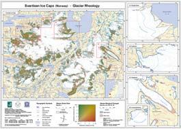
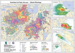
9 Map Design Title and Content Svartisen Ice Caps (Norway) Glacier Rheology Hintereisferner (Austria) Glacier Rheology Title Glacier Marginal Changes Glacier Strain Rate Glacier Velocity Original Interferogram EROS Orthoimage Map Topic 2 nd glacier stadium Areas of in- and decrease Rates of deformation Flow velocity Interferogram EROS satellite image Topography Coast line Glacier area Hydrography Elevation contours Spot heights Lettering
10 Map Design Scale & Geodetic Parameters Base maps/ scale Geodetic parameters Glacier actuality Digital elevation data Topics Scale Grid width Svartisen Ice Caps Topografisk Hovedkartserie M711 1 : Main maps Differential Interferogram Glacier Strain Rate 1 : km Ellipsoid WGS 84 Projection: UTM Grid: UTM 1997/2000 Raster data, resolution 25 m Detailed maps Glacier Velocity Glacier Marginal Changes 1 : km Main map Glacier Marginal Changes 1 : km Hintereisferner Österreichische Karte 1 : ÖK 50 Ellipsoid: Bessel Projection: Gauss-Krueger Grid: Austrian Bundesmeldenetz (BMN) 1998 Elevation contours Secondary maps Eros Orthoimage Map Original Interferogram Glacier Velocity Glacier Strain Rate 1 : km

11 Map Design Layout Svartisen Ice Caps Format 55 cm * 40 cm landscape Area 370 km² 30 km N-S 40 km W-E 0.5 cm margins 0.5 cm frame for coordinates Foldable to smaller than A4

12 Map Design Layout Hintereisferner Format 55 cm * 40 cm portait Area 8 km² 8 km N-S 8 km W-E 0.5 cm margins 0.5 cm frame for coordinates Foldable to smaller than A4

13 Glacier Marginal Changes Areas of in- and decrease of glacier Comparison of two known stadia 1st stadium: digitised from topographic map 2nd stadium: classified from satellite images Generalisation Area > 2500 m² Area/Perimeter > 10 m

14 Glacier Strain Rate Based on the fluxograms Strain rate in x- and y- direction Green: y-direction Red: x-direction IHS colour space: Intensity: Hue: Saturation:


15 Glacier Velocity Based on velograms Intensity increases proportional to hue helix in IHS colour space IHS colour space: Intensity: Hue: Saturation: 0.85

16 The Map Series

17 Proposal I: Useful Glacier Strain Rate Maps Realised presentation: Without classification Continuous colour gradient Direction-dependent Indicative for crevasses

18 Proposal I: Useful Glacier Strain Rate Maps - I Proposed classification with three classes of strain rate Value-dependent No perceptibility of direction of crevasses Highly generalised

19 Proposal I: Useful Glacier Strain Rate Maps - II Proposed classification with five classes of strain rate Direction-dependent 5 classes Perceptibility of direction of crevasses
20 Proposal II: 3D-Visualisation Intention & Realisation Objective: Visualisation of highly-complex phenomena in a user-friendly way suitable for fieldwork. OMEGA: Not only the changes in glacier coverage are of interest, also the alterations in thickness, and, hence, in the mass-household are important!

21 Principle of Lenticular Foil Technology lenticular sheet f = focal length R = lens radius interlaced image


22 Interlacing of Stereo-Mates thickness M r M: centre of the lens r: lens radius image-/focal plane right central left stereo-mate width
23 Effects of lenticular displays 2D Effects Flip Morphing Zoom Animation Changed after MICRO LENS TECHNOLOGY D Effects True-3D Combined Effects All combinations of 2D- and 3D Effects
24 Workflow and Software Modelling Publishing Display MatLab/C++ Magic Interlacer Flashband Generator
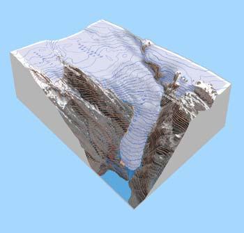
25 3D-Modelling
26 Virtual Camera Disposition convergent vs. parallel
27 ... to sum it up: True-3D hardcopies: a new subject in scientific cartography with a high potential for tourism and outdoor activities. To be investigated in more detail: cognitive, syntactic and semantic aspects of cartographic models perceived in true-3d as well as geometric and material aspects of lens foils.
28 Acknowledgements The initiative of the work presented, the input-data provision and the eager interest in our map design of Dr. Alexej Sharov, Institute of Digital Image Processing of Joanneum Research, Graz, Austria, is thankfully acknowledged. So are the valuable contributions, both in terms of brainwork and hands-on work, carried out by Sebastian Walther, Sven-Heico Etzold and Thomas Gruendemann, IfC, TU Dresden.
29 The presented types of new glacier dynamics maps allow to cartographically visualise areas which are potentially dangerous due to the occurrence of crevasses, even under a hiding cover of snow. In connection with the increasing winter outdoor-tourism in glaciated areas these types of maps may help to increase safety in alpine and polar regions. For further questions please contact: Manfred.Buchroithner@tu-dresden.de KlausHabermann@tu-dresden.de
30 USPs Unique Selling Propositions In contrast to anaglyphs, chromo-stereoscopy, active and passive polarisation: No glasses required No active or special illumination required Spontaneous stereoscopic perception Multi-user capability Multi-scene-displays Short animations possible Easily portable No energy (electric power) required Bendable (even foldable) displays
3D SURVEYING AND VISUALIZATION OF THE BIGGEST ICE CAVE ON EARTH
 CO-015 3D SURVEYING AND VISUALIZATION OF THE BIGGEST ICE CAVE ON EARTH BUCHROITHNER M.F., MILIUS J., PETTERS C. Dresden University of Technology, DRESDEN, GERMANY ABSTRACT The paper deals with the first
Satellite-based measurement of the surface displacement of the largest glacier in Austria
 Conference Volume 4 th Symposium of the Hohe Tauern National Park for Research in Protected Areas September 17 th to 19 th, 2009, Castle of Kaprun pages 145-149 Satellite-based measurement of the surface
Observations of glacier dynamics with PALSAR DATA
 Observations of glacier dynamics with PALSAR DATA Tazio Strozzi, Urs Wegmüller and Charles Werner Gamma Remote Sensing, Gümligen, Switzerland Rhodes, Greece, 3 to 7 November 2008 Outline ESA GLOBGLACIER
Land Figures & Spatial Data Infrastructure in KOSOVO
 Land Figures & Spatial Data Infrastructure in KOSOVO Idriz SHALA idriz.shala@gmail.com GIS -expert Afrim SHARKU afrim.sharku@gmail.com Land Management - Expert Kick-off meeting of the Regional Expert Advisory
Active Glacier Protection in Austria - An adaptation strategy for glacier skiing resorts
 in Austria - An adaptation strategy for glacier skiing resorts Presented by Marc Olefs Ice and Climate Group, Institute of Meteorology And Geophysics, University of Innsbruck Centre for Natural Hazard
EVALUATION OF DIFFERENT METHODS FOR GLACIER MAPPING USING LANDSAT TM
 EVALUATION OF DIFFERENT METHODS FOR GLACIER MAPPING USING LANDSAT TM Frank Paul Department of Geography, University of Zurich, Switzerland Winterthurer Strasse 190, 8057 Zürich E-mail: fpaul@geo.unizh.ch,
Ground Deformation Monitoring at Natural Gas Production Sites using Interferometric SAR
 Ground Deformation Monitoring at Natural Gas Production Sites using Interferometric SAR By: Kanika Goel, Robert Shau, Fernando Rodriguez Gonzalez, Nico Adam Remote Sensing Technology Institute (IMF), German
Evolution of Ossoue glacier, French Pyrenees: Tools and methods to generate a regional climate-proxy
 Evolution of Ossoue glacier, French Pyrenees: Tools and methods to generate a regional climate-proxy Renaud MARTI ab, Simon GASCOIN a, Thomas HOUET b, Dominique LAFFLY b, Pierre RENE c a CESBIO b GEODE,
GEOSPATIAL ANALYSIS OF GLACIAL HAZARDS PRONE AREAS OF SHIGAR AND SHAYOK BASINS OF PAKISTAN. By Syed Naseem Abbas Gilany
 GEOSPATIAL ANALYSIS OF GLACIAL HAZARDS PRONE AREAS OF SHIGAR AND SHAYOK BASINS OF PAKISTAN By Syed Naseem Abbas Gilany PRESENTATION OUTLINE Introduction Problem Statement / Rationale Objectives Material
Glaciers. Reading Practice
 Reading Practice A Glaciers Besides the earth s oceans, glacier ice is the largest source of water on earth. A glacier is a massive stream or sheet of ice that moves underneath itself under the influence
CRYOSPHERE ACTIVITIES IN SOUTH AMERICA. Bolivia. Summary
 WORLD METEOROLOGICAL ORGANIZATION GLOBAL CRYOSPHERE WATCH (GCW) CryoNet South America Workshop First Session Santiago de Chile, Chile 27-29 October 2014 GCW-CNSA-1 / Doc. 3.1.2 Date: 20 October 2014 AGENDA
Public-Private Partnership (PPP)
") Public-Private Partnership (PPP) between the State of Bavaria and the German Alpine Association (DAV) to produce topographic maps of the Bavarian Alps in the scale of 1:25 000 Walter HENNINGER Overview
Public-Private Partnership (PPP) between the State of Bavaria and the German Alpine Association (DAV) to produce topographic maps of the Bavarian Alps in the scale of 1:25 000 Walter HENNINGER Overview
EO-based services to support humanitarian operations: monitoring population and natural resources in refugee/idp camps
 How satellites can help to save lives Vienna, Austria 23 February 2016 EO-based services to support humanitarian operations: monitoring population and natural resources in refugee/idp camps Petra FÜREDER
Glaciers Earth 9th Edition Chapter 18 Mass wasting: summary in haiku form Glaciers Glaciers Glaciers Glaciers Formation of glacial ice
 1 2 3 4 5 6 7 8 9 10 11 12 13 14 15 Earth 9 th Edition Chapter 18 Mass wasting: summary in haiku form Ten thousand years thence big glaciers began to melt - called "global warming." are parts of two basic
Chapter 16 Glaciers and Glaciations
 Chapter 16 Glaciers and Glaciations Name: Page 419-454 (2nd Ed.) ; Page 406-439 (1st Ed.) Part A: Anticipation Guide: Please read through these statements before reading and mark them as true or false.
Data Origination, Management and WGS 84. ICAO PBN Seminar Data Origination & Management and WGS 84
 Data Origination, Management and WGS 84 1 Learning Objectives Overview Understand the implication of publishing incorrect navigational data in the State s AIP Identify why it is essential to use a common
Geomorphology. Glacial Flow and Reconstruction
 Geomorphology Glacial Flow and Reconstruction We will use simple mathematical models to understand ice dynamics, recreate a profile of the Laurentide ice sheet, and determine the climate change of the
Platform and Products
 International Partnership Space Programme Earth Observation for the Preservation of Ecological Bacalar Corridor Platform and Products Terri Freemantle, Raffaella Guida, Paula Marti, Pasquale Iervolino
Glaciers and Glaciation Earth - Chapter 18 Stan Hatfield Southwestern Illinois College
 Glaciers and Glaciation Earth - Chapter 18 Stan Hatfield Southwestern Illinois College Glaciers Glaciers are parts of two basic cycles: 1. Hydrologic cycle 2. Rock cycle A glacier is a thick mass of ice
Overview ICAO Standards and Recommended Practices for Aerodrome Mapping Data reported to AIM
 Overview ICAO Standards and Recommended Practices for Aerodrome Mapping Data reported to AIM References ICAO SARPS Annex 14 Vol. I, 7 th Edition, July 2016 ICAO SARPS Annex 15, 15 th Edition, July 2016
STATE -OF-ART OF GEODESY IN THE REPUBLIC OF MACEDONIA
 STATE -OF-ART OF GEODESY IN THE REPUBLIC OF MACEDONIA Prof. Zlatko Srbinoski PhD Faculty of Civil Engineering Chair for high geodesy VIENNA, JULY 2008 REPUBLIC OF MACEDONIA Center of Balkan Peninsula a2
Changing Landscapes: Glaciated Landscapes. What are glaciers?
 Changing Landscapes: Glaciated Landscapes What are glaciers? What you need to know Types of ice mass at a range of scales including cirque glaciers, valley glaciers, highland ice field, piedmont glaciers,
New measurements techniques
 2 nd Asia CryoNetWorkshop New measurements techniques Xiao Cunde (SKLCS/CAS and CAMS/CMA) Feb.5, 2016, Salekhard, Russia Outline Definition of New Some relative newly-used techniques in China -- Eddy covariance
MIDDLE SCHOOL CURRICULUM TR AILING ICE AGE M YST ERI E S ICE AGE TREKKING
 MIDDLE SCHOOL CURRICULUM TR AILING ICE AGE M YST ERI E S ICE AGE TREKKING CONTENTS I. Enduring Knowledge... 3 II. Teacher Background... 3 III. Before Viewing this Video... 5 IV. Viewing Guide... 5 V. Discussion
MIDDLE SCHOOL CURRICULUM TR AILING ICE AGE M YST ERI E S SEARCHING GLACIAL FEATURES
 MIDDLE SCHOOL CURRICULUM TR AILING ICE AGE M YST ERI E S SEARCHING GLACIAL FEATURES CONTENTS I. Enduring Knowledge... 3 II. Teacher Background... 3 III. Before Viewing the Video... 5 IV. Viewing Guide...
TEACHER PAGE Trial Version
 TEACHER PAGE Trial Version * After completion of the lesson, please take a moment to fill out the feedback form on our web site (https://www.cresis.ku.edu/education/k-12/online-data-portal)* Lesson Title:
The Potentially Dangerous Glacial Lakes
 Chapter 11 The Potentially Dangerous Glacial Lakes On the basis of actively retreating glaciers and other criteria, the potentially dangerous glacial lakes were identified using the spatial and attribute
Tidewater Glaciers: McCarthy 2018 Notes
 Tidewater Glaciers: McCarthy 2018 Notes Martin Truffer, University of Alaska Fairbanks June 1, 2018 What makes water terminating glaciers special? In a normal glacier surface mass balance is always close
along a transportation corridor in
 Rockfall hazard and risk assessment along a transportation corridor in the Nera Valley, Central Italy Presentation on the paper authored by F. Guzzetti and P. Reichenbach, 2004 Harikrishna Narasimhan Eidgenössische
Using of space technologies for glacierand snow- related hazards studies
 United Nations / Germany international conference on International Cooperation Towards Low-Emission and Resilient Societies Using of space technologies for glacierand snow- related hazards studies Bonn,
Investigation on Development of Agricultural Monitoring System Using Satellite Data
 Investigation on Development of Agricultural Monitoring System Using Satellite Data Genya SAITO (1), Daisuke KUNII (1), Naoki ISHITSUKA (2) (1) Tohoku University, 1-1,Tsutsumidori Amamiya-machi Aoba-ku,
MEASUREMENT OF THE RETREAT OF QORI KALIS GLACIER IN THE TROPICAL ANDES OF PERU BY TERRESTRIAL PHOTOGRAMMETRY ABSTRACT
 MEASUREMENT OF THE RETREAT OF QORI KALIS GLACIER IN THE TROPICAL ANDES OF PERU BY TERRESTRIAL PHOTOGRAMMETRY Henry H. Brecher and Lonnie G. Thompson Byrd Polar Research Center, The Ohio State Univessity
CRYOSPHERE NEPAL. BIKRAM SHRESTHA ZOOWA Sr. Hydrologist Department of Hydrology and Meteorology NEPAL 2016
 CRYOSPHERE NEPAL BIKRAM SHRESTHA ZOOWA Sr. Hydrologist Department of Hydrology and Meteorology NEPAL 2016 ORGANISATIONAL STRUCTURE Ministry of Science, Technology and Environment DEPARTMENT OF HYDROLOGY
Recent Changes in Glacier Tongues in the Langtang Khola Basin, Nepal, Determined by Terrestrial Photogrammetry
 Snow and Glacier Hydrology (Proceedings of the Kathmandu Symposium, November 1992). IAHSPubl. no. 218,1993. 95 Recent Changes in Glacier Tongues in the Langtang Khola Basin, Nepal, Determined by Terrestrial
PHY 133 Lab 6 - Conservation of Momentum
 Stony Brook Physics Laboratory Manuals PHY 133 Lab 6 - Conservation of Momentum The purpose of this lab is to demonstrate conservation of linear momentum in one-dimensional collisions of objects, and to
Retreating Glaciers of the Himalayas: A Case Study of Gangotri Glacier Using Satellite Images
 Retreating Glaciers of the Himalayas: A Case Study of Gangotri Glacier Using 1990-2009 Satellite Images Jennifer Ding Texas Academy of Mathematics and Science (TAMS) Mentor: Dr. Pinliang Dong Department
Development of Sea Surface Temperature in the Baltic Sea in 2010
 HELCOM Baltic Sea Environment Fact Sheets 2011 1 Development of Sea Surface Temperature in the Baltic Sea in 2010 Authors: Herbert Siegel and Monika Gerth Baltic Sea Research Institute Warnemünde (IOW)
I. Types of Glaciers 11/22/2011. I. Types of Glaciers. Glaciers and Glaciation. Chapter 11 Temp. B. Types of glaciers
 Why should I care about glaciers? Look closely at this graph to understand why we should care? and Glaciation Chapter 11 Temp I. Types of A. Glacier a thick mass of ice that originates on land from the
Using LiDAR to study alpine watersheds. Chris Hopkinson, Mike Demuth, Laura Chasmer, Scott Munro, Masaki Hayashi, Karen Miller, Derek Peddle
 Using LiDAR to study alpine watersheds Chris Hopkinson, Mike Demuth, Laura Chasmer, Scott Munro, Masaki Hayashi, Karen Miller, Derek Peddle Light Detection And Ranging r t LASER pulse emitted and reflection
Paracentesis Incision Knives
 Paracentesis Incision ClearPort Paracentesis Technology = Superior r Wound Architec ture Exceptional Wound Architecture Created for consistent and accurate wound architecture to achieve self-sealing wounds
CONTROL IS EVERYTHING THE SURGEON S EDGE
 CONTROL IS EVERYTHING THE SURGEON S EDGE Sharpoint Microsurgical Knives Catalog Innovative Designs Proprietary Finishing Technology Trusted In Ophthalmology Paracentesis Incision Knives ClearPort Paracentesis
M i c r o s u r g i c a l K n i v e s
 Microsurgical Knives Paracentesis Incision Knives ClearPort Paracentesis Knives Technology = Superior Wound Architecture Exceptional Wound Architecture Created for consistent and accurate wound architecture
agis a brief overview
 agis a brief overview Steve Welebny Photogrammetrist Keystone Aerial Surveys Villanova University 1 Villanova University 2 Nav Aid Cost VOR Install = $250,000 20 year life cycle cost = $1,100,000 ILS Install
Regional implementation of Electronic Terrain and Obstacle data (e-tod) (Presented by Jeppesen)
 (Presented by Jeppesen)") International Civil Aviation Organization SAM/IG/13-WP/39 South American Regional Office 5/04/14 Thirteenth Workshop/Meeting of the SAM Implementation Group English only (SAM/IG/13) - Regional Project
International Civil Aviation Organization SAM/IG/13-WP/39 South American Regional Office 5/04/14 Thirteenth Workshop/Meeting of the SAM Implementation Group English only (SAM/IG/13) - Regional Project
MODAIR. Measure and development of intermodality at AIRport
 MODAIR Measure and development of intermodality at AIRport M3SYSTEM ANA ENAC GISMEDIA Eurocontrol CARE INO II programme Airports are, by nature, interchange nodes, with connections at least to the road
THE NET VOLUMETRIC LOSS OF GLACIER COVER WITHIN THE BOW VALLEY ABOVE BANFF, /
 THE NET VOLUMETRIC LOSS OF GLACIER COVER WITHIN THE BOW VALLEY ABOVE BANFF, 1951-1993 1/ ABSTRACT CHRIS HOPKINSON 2/ Three methods have been used to explore the volumetric change of glaciers in the Bow
Visitor Management Plan innovative and hospitable
 Visitor Management Plan 2015-2020 innovative and hospitable Outline of policy, objectives, and enabling conditions Drawn up on 19 March 2015 1. Introduction The Visitor Management Plan 2015-2020 outlines
J. Oerlemans - SIMPLE GLACIER MODELS
 J. Oerlemans - SIMPE GACIER MODES Figure 1. The slope of a glacier determines to a large extent its sensitivity to climate change. 1. A slab of ice on a sloping bed The really simple glacier has a uniform
2. (1pt) From an aircraft, how can you tell the difference between a snowfield and a snow-covered glacier?
 From an aircraft, how can you tell the difference between a snowfield and a snow-covered glacier?") 1 GLACIERS 1. (2pts) Define a glacier: 2. (1pt) From an aircraft, how can you tell the difference between a snowfield and a snow-covered glacier? 3. (2pts) What is the relative size of Antarctica, Greenland,
1 GLACIERS 1. (2pts) Define a glacier: 2. (1pt) From an aircraft, how can you tell the difference between a snowfield and a snow-covered glacier? 3. (2pts) What is the relative size of Antarctica, Greenland,
Chapter 7 Snow and ice
 Chapter 7 Snow and ice Throughout the solar system there are different types of large ice bodies, not only water ice but also ice made up of ammonia, carbon dioxide and other substances that are gases
Lidar Imagery Reveals Maine's Land Surface in Unprecedented Detail
 Maine Geologic Facts and Localities December, 2011 Lidar Imagery Reveals Maine's Land Surface in Unprecedented Detail Text by Woodrow Thompson, Department of Agriculture, Conservation & Forestry 1 Introduction
Field Report Snow and Ice Processes AGF212
 Field Report 2013 Snow and Ice Processes AGF212 (picture) Names... Contents 1 Estimation of ice thickness and snow distribution using Ground Penetrating Radar 1 1.1 Introduction..................................................
Guidance for Complexity and Density Considerations - in the New Zealand Flight Information Region (NZZC FIR)
") Guidance for Complexity and Density Considerations - in the New Zealand Flight Information Region (NZZC FIR) Version 1.0 Director NSS 14 February 2018 Guidance for Complexity and Density Considerations
Guidance for Complexity and Density Considerations - in the New Zealand Flight Information Region (NZZC FIR) Version 1.0 Director NSS 14 February 2018 Guidance for Complexity and Density Considerations
RACOON PROJECT Daniele Teotino - ENAV. RACOON Project Manager Head of SESAR JU Activity Coordination
 RACOON PROJECT Daniele Teotino - ENAV RACOON Project Manager Head of SESAR JU Activity Coordination RACOON in a Nutshell SESAR JU Very Large Scale Demonstration First Italian initiative on Remote TWR solutions
GLACIER INVENTORY OF JAMES ROSS AND VEGA ISLANDS, ANTARCTIC PENINSULA*
 Annals of Glaciology 3 1982 International Glaciological Society GLACIER INVENTORY OF JAMES ROSS AND VEGA ISLANDS, ANTARCTIC PENINSULA* by Jorge Rabassa, (Comisi6n de Investigaciones Cientificas, Provincia
CONTROL IS EVERYTHING THE SURGEON S EDGE
 CONTROL IS EVERYTHING THE SURGEON S EDGE Sharpoint Microsurgical Knives Catalog Innovative Designs Proprietary Finishing Technology Trusted In Ophthalmology Paracentesis Incision Knives ClearPort Paracentesis
Glaciers. Chapter 17
 Glaciers Chapter 17 Vocabulary 1. Glacier 2. Snowfield 3. Firn 4. Alpine glacier 5. Continental glacier 6. Basal slip 7. Internal plastic flow 8. Crevasses 9. Glacial grooves 10. Ice shelves 11. Icebergs
ICAO Big Data Project ADS-B Data as a source for analytical solutions for traffic behaviour in airspace
 ICAO Big Data Project ADS-B Data as a source for analytical solutions for traffic behaviour in airspace ICAO/IATA/CANSO PBN/2 San Jose December 8, 2016 Big Data process Quantitative Quantitative / Qualitative
A high resolution glacier model with debris effects in Bhutan Himalaya. Orie SASAKI Kanae Laboratory 2018/02/08 (Thu)
") A high resolution glacier model with debris effects in Bhutan Himalaya Orie SASAKI Kanae Laboratory 2018/02/08 (Thu) Research flow Multiple climate data at high elevations Precipitation, air temperature
A high resolution glacier model with debris effects in Bhutan Himalaya Orie SASAKI Kanae Laboratory 2018/02/08 (Thu) Research flow Multiple climate data at high elevations Precipitation, air temperature
EA-12 Coupled Harmonic Oscillators
 Introduction EA-12 Coupled Harmonic Oscillators Owing to its very low friction, an Air Track provides an ideal vehicle for the study of Simple Harmonic Motion (SHM). A simple oscillator assembles with
Mountain Peak Platform Top of Tyrol
 Project Mountain Peak Platform Top of Tyrol Site Mount Isidor Stubai glacier in Tirol, Austria. 3200m. Accessible by cable car [8h 16h] Client Wintersport Tirol AG & Co, Stubaier Bergbahnen KG CEO Reinhard
Integration Of Reflectance To Study Glacier Surface Using Landsat 7 ETM+: A Case Study Of The Petermann Glacier In Greenland
 Integration Of Reflectance To Study Glacier Surface Using Landsat 7 ETM+: A Case Study Of The Petermann Glacier In Greenland Félix O. Rivera Santiago Department Of Geology, University Of Puerto Rico, Mayaguez
E-9093 Ice Class Ship Structures
 E-9093 Ice Class Ship Structures by Claude Daley Professor of Ocean and Naval Architectural Engineering Part 1 Overview of Arctic Shipping Topics Ice Class Ships 1 Overview of Arctic Shipping Ice What
COSMO-Coast. L Aquila. La Sapienza. Tor Vergata. Dipartimento di Architettura ed Urbanistica. Dipartimento di Informatica, Sistemi e Produzione,
 COSMO-Coast Tor Vergata Dipartimento di Informatica, Sistemi e Produzione, L Aquila Dipartimento di Architettura ed Urbanistica La Sapienza Dipartimento Ingegneria Civile, Edile ed Ambientale Introduction
THE DEPARTMENT OF HIGHER EDUCATION UNIVERSITY OF COMPUTER STUDIES FIFTH YEAR
 THE DEPARTMENT OF HIGHER EDUCATION UNIVERSITY OF COMPUTER STUDIES FIFTH YEAR (B.C.Sc./B.C.Tech.) RE- EXAMINATION SEPTEMBER 2018 Answer all questions. ENGLISH Time allowed: 3 hours QUESTION I Glaciers A
STUDY OF ALAQI SECONDARY CHANNEL IN LAKE NASSER
 ABSTRACT STUDY OF ALAQI SECONDARY CHANNEL IN LAKE NASSER GamalSallam 1, Mohamed Ihab 2, and Waleed Emary 3 Associate Professor, National Water Research Center, Email: gasallam@yahoo.com Civil Engineer,
Assessment of the ice throw and ice fall risks nearby wind energy installations
 Assessment of the ice throw and ice fall risks nearby wind energy installations Michaela Kaposvari, Thorsten Weidl TÜV SÜD Industrie Service GmbH, Winterwind, February 4 th, 2015 Folie 2 Initial Situation
VERSION 1.0. CREATED 2014
 VISUAL IDENTITY GUIDELINES VERSION 1.0. CREATED 2014 VALLETTA 2018 I VISUAL IDENTITY GUIDELINES 1 2 VALLETTA 2018 I VISUAL IDENTITY GUIDELINES CONTENTS The Valletta 2018 brandmark 5 How the use our brandmark
Observation of cryosphere
 Observation of cryosphere By Sagar Ratna Bajracharya (email: sagar.bajracharya@icimod.org) Samjwal Ratna Bajracharya Arun Bhakta Shrestha International Centre for Integrated Mountain Development Kathmandu,
Contextual note SESAR Solution description form for deployment planning
 Purpose: Release 5 SESAR Solution ID #12 Contextual note SESAR Solution description form for deployment planning This contextual note introduces a SESAR Solution (for which maturity has been assessed as
Egg-streme Parachuting Flinn STEM Design Challenge
 Egg-streme Parachuting Flinn STEM Design Challenge 6 07, Flinn Scientific, Inc. All Rights Reserved. Reproduced for one-time use with permission from Flinn Scientific, Inc. Batavia, Illinois, U.S.A. No
Location: 2. It shows on at least two more places an example of the principle of dichotomy,
 Problem 1 - Requirements Discovery for a Mars formation flying mission (45 minutes, 24 points) Delft University of Technology Course: Systems Engineering & Technical Time: Management Techniques (AE3-S01)
UAS to GIS Utilizing a low-cost Unmanned Aerial System (UAS) for Coastal Erosion Monitoring
 for Coastal Erosion Monitoring") UAS to GIS Utilizing a low-cost Unmanned Aerial System (UAS) for Coastal Erosion Monitoring Agenda Scope of today s presentation Demonstration Objectives Wrightsville Beach Test Area Masonboro Inlet Jetties
UAS to GIS Utilizing a low-cost Unmanned Aerial System (UAS) for Coastal Erosion Monitoring Agenda Scope of today s presentation Demonstration Objectives Wrightsville Beach Test Area Masonboro Inlet Jetties
Figure Pre- and post-disaster satellite topographical maps
 2.1.3 Image analysis by JAXA JAXA conducted ongoing emergency observations using Daichi in the wake of the Great East Japan Earthquake, releasing reporting of its analysis of eastern Japan and Hokkaido
NivoTest : a personal assistant for avalanche risk assessment
 NivoTest : a personal assistant for avalanche risk assessment R.Bolognesi METEISK, CP 993, CH-1951 SION. www.meteorisk.com Introduction About avalanche risk Every mountaineer knows that avalanche hazard
REPUBLIC OF SOUTH AFRICA
 REPUBLIC OF SOUTH AFRICA SAN HYDROGRAPHIC OFFICE NATIONAL REPORT TO THE IHO HYDROGRAPHIC COMMISSION ON ANTARCTICA (HCA) 11 TH MEETING, HOBART, AUSTRALIA 05-07 OCTOBER 2011 2 11 TH HCA MEETING REPORT BY
Revised Draft: May 8, 2000
 Revised Draft: May 8, 2000 Accepted for publication by the International Association of Hydrological Sciences. Paper will be presented at the Debris-Covered Glaciers Workshop in September 2000 at the University
Effect of Support Conditions on Static Behavior of 1400m main span and 700m side span Cable-stayed Bridge
 Effect of Support Conditions on Static Behavior of 1400m main span and 700m side span Cable-stayed Bridge Prof. G. M. Savaliya Department of Civil Engineering Government Engineering College, Surat, Gujarat,
Glacial lakes as sentinels of climate change in Central Himalaya, Nepal
 Glacial lakes as sentinels of climate change in Central Himalaya, Nepal Sudeep Thakuri 1,2,3, Franco Salerno 1,3, Claudio Smiraglia 2,3, Carlo D Agata 2,3, Gaetano Viviano 1,3, Emanuela C. Manfredi 1,3,
USING REMOTE SENSING AND RPAS FOR ARCHAEOLOGY AND MONITORING IN WESTERN GREENLAND
 USING REMOTE SENSING AND RPAS FOR ARCHAEOLOGY AND MONITORING IN WESTERN GREENLAND K. Pavelka*, J. Šedina, E. Matoušková, M. Faltýnová, I.Hlaváčová Department of Mapping and Cartography, Faculty of Civil
LAB P - GLACIAL PROCESSES AND LANDSCAPES
 Introduction LAB P - GLACIAL PROCESSES AND LANDSCAPES Ice has been a significant force in modifying the surface of the earth at numerous times throughout Earth s history. Though more important during the
Climate Change Impact on Water Resources of Pakistan
 Pakistan Water and Power Development Authority (WAPDA) Climate Change Impact on Water Resources of Pakistan Glacier Monitoring & Research Centre Muhammad Arshad Pervez Project Director (GMRC) Outline of
Interreg Vb /Prowad Link WP6.5. Feasibilitystudy, nature tourism routes around the North Sea Region Project description
 Interreg Vb, North Sea Region Prowad Link project Feasibility study: Nature tourism route around the North Sea Region, 2019 / specification 06.02.2019 Background Interreg Vb, North Sea Region, project
Contextual note SESAR Solution description form for deployment planning
 Purpose: Release 5 SESAR Solution #13 Contextual note SESAR Solution description form for deployment planning This contextual note introduces a SESAR Solution (for which maturity has been assessed as sufficient
PCH Hotels and Resorts Delivers State-of-the-Art Guest Experience
 PCH Hotels and Resorts Delivers State-of-the-Art Guest Experience Renaissance Montgomery Hotel and Spa Relies on Cisco Network to Return to Grand Tradition of Southern Hospitality EXECUTIVE SUMMARY PCH
TWENTY-SECOND MEETING OF THE ASIA/PACIFIC AIR NAVIGATION PLANNING AND IMPLEMENTATION REGIONAL GROUP (APANPIRG/22)
") INTERNATIONAL CIVIL AVIATION ORGANIZATION TWENTY-SECOND MEETING OF THE ASIA/PACIFIC AIR NAVIGATION PLANNING AND IMPLEMENTATION REGIONAL GROUP (APANPIRG/22) Bangkok, Thailand, 5-9 September 2011 Agenda
INTERNATIONAL CIVIL AVIATION ORGANIZATION TWENTY-SECOND MEETING OF THE ASIA/PACIFIC AIR NAVIGATION PLANNING AND IMPLEMENTATION REGIONAL GROUP (APANPIRG/22) Bangkok, Thailand, 5-9 September 2011 Agenda
Airport Safety Initiative Networking Session Initiated by the Airport Safety Cluster. Helsinki, IST Event /11/ 2006,16:00-17:30
 Airport Safety Initiative Networking Session Initiated by the Airport Safety Cluster Helsinki, IST Event 2006 22/11/ 2006,16:00-17:30 Agenda 16:00 Welcome (Andrea Kurz, Airport Safety Cluster) 16:05 Setting
Ensemble methods for ice sheet init.
 Ensemble methods for ice sheet model initialisation Bertrand Bonan 1 Maëlle Nodet 1,2 Catherine Ritz 3 : INRIA Laboratoire Jean Kuntzmann (Grenoble) 2 3 1 : Université Joseph Fourier (Grenoble) : CNRS
AIRBORNE SCIENCE FLIGHT REQUEST National Aeronautics and Space Administration
 AIRBORNE SCIENCE FLIGHT REQUEST National Aeronautics and Space Administration LOG NUMBER Investigation Title: Rationale for use of NASA Facilities: NASA RTOP If checked, RTOP Number/Grant or Contract #
Federal GIS Conference February 10 11, 2014 Washington DC. ArcGIS for Aviation. David Wickliffe
 Federal GIS Conference 2014 February 10 11, 2014 Washington DC ArcGIS for Aviation David Wickliffe What is ArcGIS for Aviation? Part of a complete system for managing data, products, workflows, and quality
Aircraft Noise. Why Aircraft Noise Calculations? Aircraft Noise. SoundPLAN s Aircraft Noise Module
 Aircraft Noise Why Aircraft Noise Calculations? Aircraft Noise Aircraft noise can be measured and simulated with specialized software like SoundPLAN. Noise monitoring and measurement can only measure the
Appendix 8: Coding of Interchanges for PTSS
 FILE NOTE DATE 23 October 2012 AUTHOR SUBJECT Geoffrey Cornelis Appendix 8: Coding of Interchanges for PTSS 1. Introduction This notes details a proposed approach to improve the representation in WTSM
Capturing that perfect landscape shot with your camera is a thrill and satisfaction everyone should experience.
 Phil North FODCC 1 Introduction Camera Settings JPEG vs. Raw ISO White Balance Colour Filters Depth of Field Camera Position Composition Lighting Conditions Lens Choice Phil North FODCC 2 Phil North FODCC
Borough High Street Low Emission Neighbourhood
 Borough High Street Low Emission Neighbourhood Colourful Crossings Design Brief Better Bankside Business Improvement District Brief for Graphic Consultants December 2017 Page 1 of 10 1. Introduction Borough
AUTOMATIC GLACIER SURFACE ANALYSIS FROM AIRBORNE LASER SCANNING
 IAPRS Volume XXXVI, Part 3 / W52, 2007 AUTOMATIC GLACIER SURFACE ANALYSIS FROM AIRBORNE LASER SCANNING M.P. Kodde a, N. Pfeifer b, B.G.H. Gorte c, T. Geist d, B. Höfle e a. Fugro-Inpark, Dillenburgsingel
The dynamic response of Kolohai Glacier to climate change
 Article The dynamic response of Kolohai Glacier to climate change Asifa Rashid 1, M. R. G. Sayyed 2, Fayaz. A. Bhat 3 1 Department of Geology, Savitribai Phule Pune University, Pune 411007, India 2 Department
Shrinkage of the Khumbu Glacier, east Nepal from 1978 to 1995
 Debris-Covered Glaciers (Proceedings of a workshop held at Seattle, Washington, USA, September 2000). IAHS Publ. no. 264, 2000. 235 Shrinkage of the Khumbu Glacier, east Nepal from 1978 to 1995 TSUTOMU
The Northeast: America's Gateway to the World
 The Northeast: America's Gateway to the World Living in the Shadow of the Ice a lesson on the impact of glaciation on Northeast landscapes INTRODUCTION: The region we call the Northeast has a very long
Optimizing trajectories over the 4DWeatherCube
 Optimizing trajectories over the 4DWeatherCube Detailed Proposal - SES Awards 2016 Airbus Defence and Space : dirk.schindler@airbus.com Luciad : robin.houtmeyers@luciad.com Eumetnet : kamel.rebai@meteo.fr
Place Glacier terrain modeling and 3D laser imaging
 Place Glacier terrain modeling and 3D laser imaging Report prepared for the National Glaciology Program of the Geological Survey of Canada In fulfillment of contract # TSD051603X By Dr. Chris Hopkinson,