Lower Eau Claire River Water Trail
|
|
|
- Norah Patrick
- 5 years ago
- Views:
Transcription


1 Lower Eau Claire River Water Trail The Adventure in Our Own Backyard


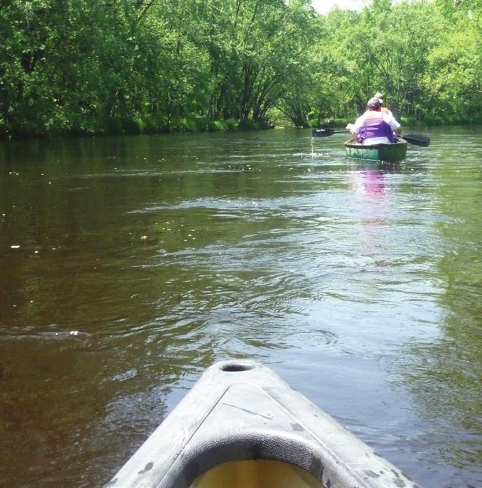
2 Our Vision Our vision is for an enhancement of a Lower Eau Claire River Water Trail that Expands opportunities for safe and fun paddling and floating. Grows recreational-based tourism development in the Wausau-Weston-Ringle area. Builds on related initiatives, like Wausau s master plan for the Eau Claire River Conservancy. Includes safe and well-marked put-in and take-out spots along the river, and advises people on how to get to these spots and navigate once there. Connects to and enhances destinations along the river, including parks and conservancies, campgrounds, school forests, and neighborhoods. Advances opportunities for land-based trails, picnic spots, and other activities along the river. Provides a consistent and appealing image through signage and informational materials. timers and tubers. Starting in Ringle, then Weston, then Wausau, and finally Schofield, the character of the river shifts. In most places, the views from the water are similar to what they might have been 00 years ago. There are already several launch sites that many people use each warm summer day. Some, like the County s launch site along Ringle Avenue in Ringle, are well-marked, include at least basic parking, a picnic spot, and a reasonable launch site. Others, like a spot at the County Highway J bridge in Weston, are very informal and t always safe in their present condition. Safety deficiencies at this and other spots often result from little to parking, heavier car and truck traffic, and very informal or hidden put-in/take-out locations. The communities along the river, Marathon County, local outfitters, and others also recognize the value and potential of the river in their efforts and plans. For example, the City of Wausau has recently established a master plan for its Eau Claire River Conservancy City-owned land on the rthern shore of the river. The land has a series of oxbow lakes, making it an ideal place to kayak and cae. The Village of Weston has, through its 05 Comprehensive Outdoor Recreation Plan, identified the water trail as a priority initiative. To advance that initiative, the Village will construct a modern launch and parking lot at the Ross Avenue Bridge (see Fig. ). This project is being supported through grants from Marathon County, the B.A. and Esther Greenheck Foundation, and the Community Foundation of North Central Wisconsin. The Village is exploring similar improvements at Yellowbanks Park and the County Highway J bridge area, which are in need of funding support. What is a water trail? A designated route for paddling or floating along a waterway with strategically located access points; similar to hiking trails and bikeways but with one difference: the trail already exists. Benefits: Recreation Ecomic Quality of Life/Health Education/Information Resource Stewardship Community Identity Finding A Put-in Spot Paddling and floating down the lower Eau Claire River is a rite of summer for many residents in the Weston-Wausau-Ringle area. The river offers a natural escape, a range of experiences, a path to healthy living, and most of all, fun! To date, most paddling occurs on an informal basis, sometimes offering a mixed quality of experience and safety. Many area residents are t aware of what the lower Eau Claire River has to offer, and others may be reluctant to cae or kayak the river. Further, paddling down the river is t on the navigation chart of most visitors to the area. Much of the proposed water trail goes through the Village of Weston. The trail also goes though parts of Wausau, Schofield, and Ringle, and passes by lands in the hands of scouting organizations, the D.C. Everest School District, and other organizations. This calls for an intergovernmental, collaborative approach to trail conception, development, and implementation. *Johnson, Lindsy Case Studies of Water Trail Impacts on Rural Communities. Masters Thesis, University of Oregon, 00. p.0. Ecomic Benefit The ecomic impact of recreation water trails has been documented by a number of studies since the early 000s. For example, in 0 the Outdoor Industry Foundation estimated that the annual national active outdoor recreation ecomy, including resources such as hiking trails and water trails, contributed $646 billion to the U.S. ecomy. In a 009 study of the ecomic impact of the Rogue River in Oregon, ECONorthwest found that river-based recreation contributed at least $0 million annually to the surrounding local ecomies. In 008, the North Carolina Paddle Tourism Study estimated that paddlers spent more than $ million dollars annually on paddle trips in North Carolina. The Outdoor Recreation Ecomy. 0. Outdoor Industry Association. pdf/oia_outdoorrececomyreport0.pdf May 0. Helvoigt, Ted L. ECONorthwest. 009 Regional Ecomic Impacts on the Wild and Scenic Rogue River. Beedle, Jennifer. 008 Paddle Tourism Study: North Carolina State Trails Program June 0. Going with the Flow The idea of a water trail is t a new one, and paddling or floating down the river already provides a special experience for many people each summer. The river, itself, is of course the most valuable asset. It is navigable from spring until late summer, and has few obstructions. During spring and early summer, when water levels are higher, the river provides an exhilarating experience for beginners and a test for more experienced paddlers. Later in the summer, the river takes on a lazier character, bringing out more first- Caeists on the Kickapoo spent over $. million in rural southwest Wisconsin.* (999) Figure : Engineering drawings for Ross Avenue Bridge river access point, including parking area, ramp and river launch, guide upcoming improvements at this site and may be a model for parking and access improvements at other spots.


")


3 Eau Claire River Conservancy rth we ste rn S Camp Del O Claire Kersten Road YMCA Camp Sturtevant.7 mi. X Ross Avenue The Lower Eau Claire River Water Trail Existing or Proposed Access Point Existing Land Trail Proposed Land Trail Public Park Town of WESTON Private Recreational Land School District Land 7 nue Ave s s Ro Eau Claire River Land Trail Mesker Street Drott Street.5 mi. Eau Claire River Nature Center 5 Kellyland Park Town of RINGLE 0.8mi.. mi. 6 Schofileld Avenue J Riverside Elementary School River Road Jelinek Avenue Schofie ld Aven Ryan Street Village of WESTON X ue mi. 0.7 mi.. mi. Mountain-Bay State Trail Mountain Bay Elementary School 9 9 This page shows the 5-mile extent of the Lower Eau Claire River Water Trail, existing and proposed access points, distances between points, other key spots along the river, and improvement opportunities. These opportunities focus on parking, ramp, picnic, restroom, and signage/wayfinding improvements for each of the access (put-in/take-out) spots--see details on next page. Some access points require minimal improvements; others require more significant investments to ensure safe and visible access. The map also shows key road and land trail connections, both existing and proposed. Because lands, trails, roads, and other facilities associated with the water trail are under different ownerships, collaborative action is required to realize the full potential of the water trail. J Ross Avenue Camp Phillips Road Grand Avenue Samoset Boy Scout Council 0 Brooks & Ross Dam 8. mi..5 mi. City of SCHOFIELD ek Yellowbanks Park Ave nu e C re enue Ringle Av DC Everest Middle School Current Condition of River Access # on map Access Point Name Parking Ramp Picnic Restrooms Signs / Wayfinding Edwin s Park on shoulder Riverside School Area on street Mountain- Bay Trail on shoulder of Ringle Ave 4 County Road J on shoulder of County J 5 Planned Park current public access 6 Ryan Street current public access at Kellyland Park 7 Ross Ave on shoulder 8 Yellowbanks Park recently improved 9 Eau Claire Conservancy 0 Brooks & Ross Dam porto-let - Edwin s Park 7 - Ross Ave. - Mountain-Bay Trail 8 - Yellowbanks Park 4 - County Road J 9 - Eau Claire Conservancy 6 - Ryan Street 0 - Brooks & Ross Dam Club House Road No E. Kent Street y and Kramer Street City of 9 WAUSAU


.")
4 Sharing Our Float Plan Scouting the Route Each access location should ideally be developed with: Specific efforts to develop the water trail include: The Value of Signage Informational, directional, and wayfinding signage is an important amenity for trail users and provides a visible benefit to the surrounding community. A good signage system increases user comfort, assists in navigation, warns of approaching obstacles, and guides users through unfamiliar terrain. Signage can direct people from road or parking to water, advise on current location and destinations, and provide directions and distances. (continued on next page) A parking lot or safe pull-off area, ideally for at least 0 motor vehicles including a few with trailers (See Fig., on earlier page). Wayfinding signage to get to each parking area, and from there to the launch (Fig. -A). A permanent display near the put-in spot that would include a you are here map showing other put-in/take-out spots, distances, other riverfront destinations, and navigation tips (Fig. -B). A launch, designed with a firm surface (despite changes in sedimentation levels), a launch area of 5 to 5 feet long and 6 to feet wide, slopes of t more than 5 percent (or 8. percent where possible to meet ADA accessibility standards), and water level of at least two feet. Handrails, step-down designs, or ropes can help paddlers balance their weight during put-in and take-out (See Fig. on earlier page). An area with a picnic table or two and a bench overlooking the river. Along the river, minimal signage is advised to provide a navigational aid while maintaining the natural experience. Each bridge should be signed, and a sign indicating the location and distance to each upcoming take-out spot should be included (Fig. -C). Some other modest navigational signage may be beneficial, particularly for beginners and emergency service personnel. These may include ¼ or ½ mile markers (Fig. -D), and arrows to help users avoid n-navigable forks (Fig. -E). Alongside the river, land trails should be developed and possibly co-branded with the water trail (See map on earlier page). Signage should be developed and installed in accordance with a unified theme. The accompanying conceptual graphics provide a starting point for more detailed design work (Fig. and Fig. ). Adaptation of this document to serve as a project brochure, including an accompanying route map. Final signage plan, including final types, logo, design, placements, and you are here route map, and then build and install the signage. Engineering design and development of put-in/take-out points some require minimal improvement while others require more significant time and investment. An annual community riverfest event, including introductions to the river for first-time users and fun activities like a rubber ducky race. Educational and promotional programming, such as a YouTube video, on river use and paddling skills. Collaboration with and among riverfront organizations and businesses, and encouragement of more. The Village of Weston cant complete these efforts or develop the Lower Eau Claire River Water Trail alone. Intergovernmental partnership with Marathon County, City of Wausau, City of Schofield, Town of Ringle, Town of Weston, and Wisconsin Department of Natural Resources is essential, and partnerships with other riverfront recreational land owners and outfitters are desired. Potential funding sources include local health care and wellness organizations, paddlers, Marathon County s Environmental Impact Fund, State Stewardship and Federal LAWCON (River Protection and Enhancement) grants, the Community Foundation of North Central Wisconsin, and the B.A. and Esther Greenheck Foundation. Figure : Visualizations of water trail signage in context. A. E. B. C. Figure : Examples of wayfinding and informational signage incorporating a unified graphical identity. D. The Value of Signage (continued from previous page) The signage system must be visible but t obtrusive, and distinctive but t distracting. It should provide information in an understandable and logical way. The user should understand at a glance what information is being conveyed. The system must also harmonize with the environment it inhabits or it will detract from its surroundings. Providing clear, concise and consistent wayfinding has many benefits. Good signage, by increasing user comfort level, can lead to increased usage. By providing a better experience, users are more likely to return. Good signage also makes for better and easier management of trails. By providing appropriate information at access points and on the water, the incidence of user conflict and negative resource impact can be reduced. Accurate location information, at predictable intervals, also provides improved EMS response and maintenance access.


5 Lower Eau Claire River Water Trail The Adventure in Our Own Backyard Prepared with assistance by: studio drxnl.com / mdroffers.com October 05
AGENDA ITEMS FOR CONSIDERATION (All items listed may be acted upon)
") OFFICIAL NOTICE AND AGENDA of a meeting of a City Board, Commission, Department, Committee, Agency, Corporation, Quasi- Municipal Corporation, or Sub-unit thereof. Meeting of the: Date/Time: Location:
OFFICIAL NOTICE AND AGENDA of a meeting of a City Board, Commission, Department, Committee, Agency, Corporation, Quasi- Municipal Corporation, or Sub-unit thereof. Meeting of the: Date/Time: Location:
The Vision for the San Juan Islands Scenic Byway
 The Vision for the San Juan Islands Scenic Byway 2 Judd Cove, Orcas Island, Courtesy of Kurt Thorson (kurtthorson.com) and San Juan County Land Bank Vision for the San Juan Islands Scenic Byway The San
Rogue River Access and Management Plan Draft Alternatives
 Rogue River Access and Management Plan Draft Alternatives The Rogue River Access and Management Plan was initiated in December, 2011 and is being led by Jackson County Parks (JCP) and Oregon Department
If we make accessibility an up-front consideration that guides our planning & design efforts.
 Cindy Burkhour, MA, CTRS, CPRP AccessRecreationGroup@juno.com 616-560-2378 Accessibility invites more trail users & their $$ to your community! If we make accessibility an up-front consideration that guides
Regional Wayfinding Sign Strategy Thurston County Trails 2017
 Regional Wayfinding Sign Strategy Thurston County Trails 2017 Partners: Members and partnering organizations of the Thurston Thrives Community Design Action Team City of Lacey, City of Olympia, City of
A Vision for South Skunk River and Chichaqua Bottoms Greenbelt
 A Vision for South Skunk River and Chichaqua Bottoms Greenbelt Photo: Jim Pease Chichaqua Bottoms Booklet 7 of 8 Greater Des Moines Water Trails and Greenways 1 2016 Table of Contents Booklet 1: Water
Willamette River Water Trail Implementation Plan June 2004
 Willamette River Water Trail Implementation Plan June 2004 Prepared by the Willamette Restoration Initiative in cooperation with Summary The Willamette River Water Trail is an opportunity waiting to happen
ROYAL GORGE PARK and RECREATION AREA. A Feat of Natural and Man-Made Engineering
 ROYAL GORGE PARK and RECREATION AREA A Feat of Natural and Man-Made Engineering As Growth Resumed in the 1870 s Town Leaders Began to Envision a Tourist Industry. The Arkansas River Canyon was advertised
Lafourche Parish Government REQUEST FOR QUALIFICATIONS. Landscape Architectural Services
 Lafourche Parish Government REQUEST FOR QUALIFICATIONS Landscape Architectural Services Bayou Lafourche Parish Multi-Use Path Feasibility Study Phase 1 And Bayou Lafourche Parish Multi-Use Path Feasibility
Chapter 6. Trail Design. Trail Design
 Chapter 6 Trail Design Trail Design The trail winds through a region rich in scenic beauty, cultural, and natural history. Volunteer landscape architects working with the Core and Planning Teams, have
Proposal to Redevelop Lower Kananaskis River-Barrier Lake. Bow Valley Provincial Park
 Frequently Asked Questions Proposal to Redevelop Lower Kananaskis River-Barrier Lake Bow Valley Provincial Park Frequently Asked Questions What has been decided? What are the details of the plan? What
Blue Trails: Protecting Rivers, Fostering Stewardship
 Blue Trails: Protecting Rivers, Fostering Stewardship What Are Blue Trails? Blue Trails are the water equivalent of hiking trails. They are created to facilitate recreation in and along rivers and water
SUMMER QUARTERLY MEETING JULY 21, Tri-State Trails is made possible by the generous support of Interact for Health.
 SUMMER QUARTERLY MEETING JULY 21, 2017 Tri-State Trails is made possible by the generous support of Interact for Health. AGENDA Welcome, introductions, and updates around the room Tri-State Trails Announcements
Wilds. Headwaters. Lakes. Oxbows. Falls
 56 5 4 3 Wilds Headwaters Lakes Oxbows Falls 57 Zones It could be said the on-the-ground essence of this master plan appears within the next 6 pages of this report. As we learned in the preceding Cultural
The Future of the Road to Revolutions. A Battle Road Scenic Byway Public Forum November 9, 2010
 The Future of the Road to Revolutions A Battle Road Scenic Byway Public Forum November 9, 2010 Who is the Battle Road Scenic Byway? Four Towns: Arlington, Lexington, Lincoln, Concord Minute Man National
COUNTY COMPREHENSIVE PLAN
 50 : Policy Statement Lewis County has a unique and attractive rural character, which makes it a wonderful place to visit and explore. The region abounds with recreation opportunities that attract visitors
Understanding the caring capacity of the visitor experience Provide facilities to support a high level user experience Address visual quality through
 Understanding the caring capacity of the visitor experience Provide facilities to support a high level user experience Address visual quality through recreation ecological restoration opportunities Collaboration
Chapter 6: POLICY AND PROCEDURE RECOMMENDATIONS
 Chapter 6 POLICY AND PROCEDURE RECOMMENDATIONS FOR SRRA Below are seven policy elements that should be considered for adoption by the Southwest Regional Recreation Authority of Virginia: 1. Develop strategies
Trails. Lois Jensen Nature Preserve is a 30 acre parcel on the north end of the city. It provides unspoiled wooded paths.
 Trails Lois Jensen Nature Preserve is a 30 acre parcel on the north end of the city. It provides unspoiled wooded paths. TRAIL S, PATHS, ROUTES AND CONNECTORS Citizen input pointed to trails, paths, bike
The Baker/Carver Regional Trail is intended to
 Section V Design Guidance The Baker/Carver Regional Trail is intended to safely accommodate 183,000 annual visits, an array of non-motorized uses, a variety of skill levels, and persons with special needs.
Welcome to the future of Terwillegar Park a Unique Natural Park
 Welcome to the future of Terwillegar Park a Unique Natural Park 1 Introduction The Terwillegar Park Concept Plan study will develop an overall concept plan, management objectives and development guidelines
Androscoggin River Trail Access Sites. North Woods. 168 miles from its source at Lake Umbagog to Merrymeeting Bay
 Androscoggin River Trail Access Sites North Woods 168 miles from its source at Lake Umbagog to Merrymeeting Bay Trail Under Construction More than 40 Public Access Sites Available Androscoggin River Watershed
CHAPTER 5. Chapter 5 Recreation Element
 CHAPTER 5 Recreation Element Chapter 5 Recreation Element The Recreation Element of the Meyers Area Plan is a supplement to the Recreation Element of the TRPA Regional Plan and the El Dorado County General
Header i
 Header i 048285014.10 Header Sub Title Body Text here. Body text here. Body text here. Section 1... 1 Executive Summary... 1 Opportunities and Constraints... 3 Overall Opportunities and Constraints Map
Camping (Primitive) Camping (RV) Electrical Potable Water Grill Established Fire Pit Picnic Table
 Camping (RV) Electrical Potable Water Grill Established Fire Pit Picnic Table") Alden - 9th Road River Mile 777 Map: 38.20833, -98.32031 Managing Agency: Kansas Department of Wildlife, Parks & Tourism Nearest Community: Alden, Rice County Kansas Developed Amenities Provided Parking
Alden - 9th Road River Mile 777 Map: 38.20833, -98.32031 Managing Agency: Kansas Department of Wildlife, Parks & Tourism Nearest Community: Alden, Rice County Kansas Developed Amenities Provided Parking
Proposal to Redevelop Lower Kananaskis River-Barrier Lake. Bow Valley Provincial Park. Frequently Asked Questions
 Proposal to Redevelop Lower Kananaskis River-Barrier Lake Bow Valley Provincial Park Frequently Asked Questions What is being proposed? What are the details of the proposal? Where is the project area located?
Appalachian Trail Community
 Harpers Ferry, West Virginia Appalachian Trail Community A Designation Program of the Appalachian Trail Conservancy The Appalachian Trail Conservancy (ATC) mission is to preserve and manage the Appalachian
O REGON TRAILS SUMMIT. Oregon Trails Summit. Rogue River National Forest
 O REGON TRAILS SUMMIT Oregon Trails Summit 2014 Rogue River National Forest OREGON TRAILS 2015: A VISION FOR THE FUTURE The 2015-2024 Oregon Statewide Trails Plan Why do a trails plan? 2005-2014 Oregon
East Carolina Council Facility Study East Carolina Scout Reservation Camp Boddie Pamlico Sea Base
 East Carolina Council Facility Study East Carolina Scout Reservation Camp Boddie Pamlico Sea Base 1 VISION OF CAMP BODDIE EAST CAROLINA SCOUT RESERVATION 1. Attract Out Of Council Troops Use our natural
Georgetown-Lewes Rail/Trail Study. Rail/Trail Study: Cool Spring to Cape Henlopen State Park New Road Extension (House Resolution No.
 Georgetown-Lewes Rail/Trail Study Rail/Trail Study: Cool Spring to Cape Henlopen State Park New Road Extension (House Resolution No. 47) August 22, 2011 Presentation Outline Background Benefits Statewide
Conexus is committed to innovation and bringing financial services to market with speed. We have a long history of innovation, including:
 Corporate Profile Saskatchewan's largest and Canada's sixth largest credit union, Conexus has been serving its members for over 80 years. Today we manage more than $7.14 billion in funds and our 900 plus
Blueways: Rivers, lakes, or streams with public access for recreation that includes fishing, nature observation, and opportunities for boating.
 Parks, Open Space and Trails PRINCE WILLIAM COUNTY 2008 COMPREHENSIVE PLAN TRAILS PLAN CONTENTS The components of the trails plan are: Intent Definitions Goals, Policies, and Action Strategies Trails Map
TWO NIGHT AGENDA. Wednesday Oct Big Ideas, Big Goals Who wants to eat the cake?
 TWO NIGHT AGENDA Wednesday Oct. 27 - Big Ideas, Big Goals Who wants to eat the cake? Survey and background info Case studies Promising projects Thursday Oct. 28 - Making it Real Who wants to help make
The Recreational Trail along Cushing Park road has been a successful addition to the city
 The Recreational Trail along Cushing Park road has been a successful addition to the city Trails TRAILS, PATHS, ROUTES AND CONNECTORS Citizen input pointed to trails, paths, bike routes, and other non-motorized
Committee. Presentation Outline
 CW-33-15 11/9/2015 Community and Corporate Services Committee November 10, 2015 1 Presentation Outline Background Vision and Objectives Study Process and Timeline Public and Stakeholder Engagement Organization
Chapter 3: Livability & Recreation
 Chapter 3: Livability & Recreation Livability & Recreation Vision A thriving community that builds upon its rich foundation of agriculture, while also providing a high quality of life through its family-friendly
Village of Weston Comprehensive Plan Conditions and Issues Volume
 Village of Weston Conditions and Issues Volume Recommended by Village Plan Commission: DATE Adopted by Village of Weston Board: DATE It s Right Here. Weston welcomes families, businesses, and sustainable
Port Gamble Shoreline Area Conceptual Trail Proposal
 The North Kitsap Trails Association is pleased to be a partner to the Kitsap Forest and Bay Project and assist Kitsap County, Forterra, Olympic Property Group, Great Peninsula Conservancy and the Port
TOURISM & PUBLIC SERVICES RURAL SIGNAGE POLICY
 Policy and Procedures Subject Title: Tourism and Public Services Rural Signage Policy Corporate Policy (Approved by Council): X Policy Ref. No.: ROADS-01-07 Administrative Policy (Approved by CAO): By-Law
A BOAT RAMP TO NOWHERE
 A BOAT RAMP TO NOWHERE A PROPOSAL FOR ACCESS TO HARVIE PASSAGE A Presentation to the City of Calgary December 2017 Presented by: Peter Crowe-Swords Bow River Trout Foundation Background: The Bow River
LANGLADE COUNTY ICE AGE NATIONAL SCENIC TRAIL CONDITIONS (As of May 18, 2017)
") LANGLADE COUNTY ICE AGE NATIONAL SCENIC TRAIL CONDITIONS (As of May 18, 2017) Due to situations beyond the control of the Langlade County Chapter of the Ice Age Trail Alliance, conditions are constantly
LANGLADE COUNTY ICE AGE NATIONAL SCENIC TRAIL CONDITIONS (As of May 18, 2017) Due to situations beyond the control of the Langlade County Chapter of the Ice Age Trail Alliance, conditions are constantly
Calgary River Access Strategy Priority Sites and Proposed Funding
 Calgary River Access Strategy Priority Sites and Proposed Funding CPS2017-0103 ATTACHMENT 2 A total of $7,660,000 (Class 5 estimate) is required to implement all sites within the Calgary River Access Strategy;
County of Elgin Tourism Signage Policy Addendum A
 1.0 INTRODUCTION County of Elgin Tourism Signage Policy Addendum A 1.1 PURPOSE OF ELGIN TOURISM SIGNAGE POLICY To define the eligibility, use, design and authority for tourism oriented directional signage
Rating: 5.0 (scale of 1-10)
") 95 Community Trail System Groundcover: 2-metre paved path, 1- metre grass buffer on either side. Location: Fort St. John Ownership: City of Fort St. John Rating: 5.0 (scale of 1-10) Strategic value: Linear
95 Community Trail System Groundcover: 2-metre paved path, 1- metre grass buffer on either side. Location: Fort St. John Ownership: City of Fort St. John Rating: 5.0 (scale of 1-10) Strategic value: Linear
Public Comment. Comment To consider extending State Park lands above River Mile 7.0
 Public To consider extending Park lands above River Mile 7.0 on the Little Spokane River for the conservation and limited recreation qualities they contain is this request. Could this be included in your
Chambers of Commerce and Lake Groups advertised this NCWRPC created online survey that was : Opened: August 22, 2012; and Closed: October 4, 2012.
 Vilas County Outdoor Recreation Survey Chambers of Commerce and Lake Groups advertised this NCWRPC created online survey that was : Opened: August 22, 202; and Closed: October 4, 202. Q What Vilas County
Waterfront Concept Plan: Community Survey Summary
 Waterfront Concept Plan: Community Survey Summary Published April 20, 2016 #1100085 Introduction The survey was one component of the public consultation process endorsed by Council in October, 2015. This
Jefferson County Non-Motorized Transportation and Recreational Trails Plan 2010
 Chapter 8: Goals and objectives Plan Update: The following update presents general principles, goals, and objectives related to non-motorized transportation facilities as a component of the overall transportation
Survey Summary. 1. Overview. Pilot Implementation Survey Toronto Parks & Trails Wayfinding Strategy (Phase II) September 30 November 6, 2017
 September 30 November 6, 2017") Survey Summary Pilot Implementation Survey Toronto Parks & Trails Wayfinding Strategy (Phase II) September 30 November 6, 2017 1. Overview Between September 30 and November 6, 2017, the City of Toronto
Survey Summary Pilot Implementation Survey Toronto Parks & Trails Wayfinding Strategy (Phase II) September 30 November 6, 2017 1. Overview Between September 30 and November 6, 2017, the City of Toronto
TRUCKEE TAHOE AIRPORT DISTRICT BOARD OF DIRECTOR STAFF REPORT
 AGENDA ITEM: 11 TRUCKEE TAHOE AIRPORT DISTRICT BOARD OF DIRECTOR STAFF REPORT AGENDA TITLE: MEETING DATE: January 24, 2018 PREPARED BY: NTPUD Agency Partnership Opportunity, Multi-Use Trailhead Access
Mississippi River Parkway Commission of Minnesota
 Mississippi River Parkway Commission of Minnesota Bluffs Region (Hastings to Iowa Border) September 23, 2016 10:00 11:30 a.m. Red Wing Ignite 419 Bush Street, Red Wing, MN Bluffs Region Agenda I. Welcome
3.0 LEARNING FROM CHATHAM-KENT S CITIZENS
 3.0 LEARNING FROM CHATHAM-KENT S CITIZENS An important aspect in developing the Chatham-Kent Trails Master Plan was to obtain input from stakeholders and the general public. Throughout the course of the
Sponsorship vermonthuts.org
 Sponsorship 2017-18 vermonthuts.org info@vermonthuts.org 802-881-3284 Vermont Huts Association is a tax-exempt 501(c)(3) nonprofit organization Enhancing Recreation Vermont Huts Association is working
CAMPER CHARACTERISTICS DIFFER AT PUBLIC AND COMMERCIAL CAMPGROUNDS IN NEW ENGLAND
 CAMPER CHARACTERISTICS DIFFER AT PUBLIC AND COMMERCIAL CAMPGROUNDS IN NEW ENGLAND Ahact. Early findings from a 5-year panel survey of New England campers' changing leisure habits are reported. A significant
Pier Enhancements April 6, 2017
 Pier Enhancements April 6, 2017 Pier Enhancement Categories Pier Plaza Improvements Contingency Play Elements Destination Differentiators Water Recreation Zone Furniture, Fixtures & Equipment Transportation
Trail Towns Using Trail Systems To Leverage Place, Tourism, and Economic Development
 Trail Towns Using Trail Systems To Leverage Place, Tourism, and Economic Development Harry Burkholder, AICP Community Planner II 324 Munson Avenue Traverse City, MI 49686 231-929-3696 burkholder@liaa.org
RIVER ACCESS STRATEGY
 RIVER ACCESS STRATEGY The River Access Strategy is a 10-year plan the City of Edmonton is developing to inform future programming, operations and infrastructure improvements that support access to the
Logo Department Name Agency Organization Organization Address Information 5700 North Sabino Canyon Road
 Logo Department Name Agency Organization Organization Address Information United States Forest Coronado National Forest 5700 North Sabino Canyon Road Department of Service Santa Catalina Ranger District
CHAPTER 3 PLANNING GOALS
 CHAPTER 3 PLANNING GOALS AND PUBLIC INPUT INTRODUCTION This portion of the Algonac Master Plan is intended to outline a course for action in achieving the community s vision for the future. Throughout
Council Policy Tourist Oriented Destination Signs
 POLICY 373 APPROVED @ City of Kelowna 1435 Water Street Kelowna, BC V1Y 1J4 250 469-8500 kelowna.ca Council Policy Tourist Oriented Destination Signs Contact Department: Civic Operations Traffic Operations
KETTLEBOWL - Distance: Approximately 13 miles Highway 52 to Polar at Highway 64.
 LANGLADE COUNTY ICE AGE NATIONAL SCENIC TRAIL CONDITIONS (As of September 7, 2017) Due to situations beyond the control of the Langlade County Chapter of the Ice Age Trail Alliance, conditions are constantly
State Park Visitor Survey
 State Park Visitor Survey Methods, Findings and Conclusions State s Department of Recreation, Park and Tourism Management surveyed state park visitor and trip characteristics, and collected evaluations
2009 RIVER TOWN OF THE YEAR AWARD APPLICATION Supplemental Material Images
 2009 RIVER TOWN OF THE YEAR AWARD APPLICATION Supplemental Material Images Our History The earliest record of settlement along the river is in 1854; one of the earliest in Carroll County. About this time
Strengthening the Ontario Trails Strategy. Report on Consultations and the Environmental Bill of Rights Registry
 Strengthening the Ontario Trails Strategy Report on Consultations and the Environmental Bill of Rights Registry Purpose To report on the feedback and information received through the regional consultations,
Okanogan Borderlands Historical Society : ;:!
 Okanogan Borderlands Historical Society : ;:! 1210 Ironwood Street Orovllle, WA 98844 ~.'.'.-f:'e~i'" "k :... November 18, 2008 Kimberly D. Bose, Secretary Federal Energy Regulatory Commission 888 First
COMMUNICATIONS DEPARTMENT (Lisa Belsanti, Director) (Joshua Schare, Public Information Officer)
 (Joshua Schare, Public Information Officer)") CITY COUNCIL UNFINISHED BUSINESS AUGUST 21, 2017 SUBJECT: INITIATED BY: SUNSET STRIP ENTERTAINMENT SHUTTLE - PILOT PROGRAM HUMAN SERVICES & RENT STABILIZATION DEPARTMENT (Elizabeth Savage, Director) 'fj1f'..
CITY COUNCIL UNFINISHED BUSINESS AUGUST 21, 2017 SUBJECT: INITIATED BY: SUNSET STRIP ENTERTAINMENT SHUTTLE - PILOT PROGRAM HUMAN SERVICES & RENT STABILIZATION DEPARTMENT (Elizabeth Savage, Director) 'fj1f'..
MEETING CONCLUSIONS. Andean South America Regional Meeting Lima, Peru 5-7 March ECOTOURISM PLANNING
 MEETING CONCLUSIONS Andean South America Regional Meeting Lima, Peru 5-7 March 2002 1.0 ECOTOURISM PLANNING 1.1 Protected Areas Ecotourism in Protected Areas is part of an integrated vision of tourism
Acquisition in fee simple of approximately one-half acre of property on the shore of Spring Lake to expand the Lakeside Beach Park.
 Lakeside Beach TF00-136 $122,550.00 in fee simple of approximately one-half acre of property on the shore of Spring Lake to exp the Lakeside Beach. 2000 River Ravines TF00-150 $910,000.00 in fee simple
Exploring State Water Trail Programs
 National Park Service U.S. Department of the Interior Rivers, Trails, and Conservation Assistance Program Exploring State Water Trail Programs Barbara Nelson- Jameson Corita Waters Jessie Egan E X P E
OREGON TOURISM LISTENING SESSION SUM M ARY
 OREGON TOURISM LISTENING SESSION SUM M ARY June 2018 T O U R I S M L I S T E N I N G S E S S I O N O V E R V I E W Travel Oregon, in partnership with the Central Oregon Visitors Association, hosted an
Silver Lake Park An Environmental Jewel for the Citizens of Prince William County
 Silver Lake Park An Environmental Jewel for the Citizens of Prince William County The Prince William Park Authority Mission Statement states: The Prince William County Park Authority will create quality
Directional Tourism Signage Programme Policies
 Directional Tourism Signage Programme Policies Introduction Directional tourism signage also known as a pay-to-play programme provides an opportunity for tourism attractions and tourism-based businesses
Design Charrette Public Meeting
 Design Charrette Public Meeting Citizen Advisory Committee Members of the Public November 2, 2011 - Theodore Wirth Chalet - 6:30-8:30 p.m. Park Background: Visitation Estimation 2010 Regional Visitation
Meeting Report. Listening Session for Greenways + Blueways May 27, LaPorte County Solid Waste & Water Conservation Office, 6:00 8:00
 May 27, 2015 LaPorte County Solid Waste & Water Conservation Office, 6:00 8:00 Of the three meeting participants, two filled out the participant survey. The demographic results were as follows: o Caucasian:
Assessing Your Trails, Keeping Them Safe and Enjoyable
 Jon Wood, PLA, ASLA Associate Vice President Stewart Bert Lynn, PLA, ASLA, LEED AP Project Manager Mecklenburg County Asset and Facility Management Assessing Your Trails, Keeping Them Safe and Enjoyable
Trans Canada Trail Signage Guidelines MADE BY CANADA
 Trans Canada Trail Signage Guidelines MADE BY CANADA Mission: We will promote and assist in the development and use of the Trans Canada Trail by supporting success at the local level in the creation of
13.1 REGIONAL TOURISM ISSUES AND SUMMARY OF FINDINGS
 13 REGIONAL TOURISM T he County of Mariposa s recreation needs and facilities fall within two categories: regional tourism and local recreation. This Element focuses on regional tourism issues related
POLICY DCS-04: Tourism Directional Sign Policy. Development and Cultural Services
 DCS-04 Page 1 of 8 POLICY DCS-04: Tourism Directional Sign Policy Development and Cultural Services Approval Date: March 11, 2008 Approval Authority: Council, Resolution No. 7 Effective Date: March 11,
Corabelle Park. Inventory. Future Development
 Corabelle Park Size: Approximately 4 acres Site Description: Corabelle Park is a relatively new park within the Murray County Park System. It is located on the south side of Corabelle Lake just off gravel
Villages at Buffalo Run East
 Villages at Buffalo Run East Neighborhood Park Subhead to title page goes here. Public Design Meeting April 9, 2015 Capital Improvement Program Commerce City s $137 million CIP is the result of a 2013
Village of Holden Strategic Priorities
 Village of Holden 20162019 Strategic Priorities 1) The Village effectively communicates its attractions and businesses to residents and visitors. 2) Holden promotes and markets itself including events
PARKS CANADA SIGNING ALONG PROVINCIAL HIGHWAYS
 Page 1 of 5 RECOMMENDED PRACTICES PART SECTION SUB-SECTION HIGHWAY SIGNS GUIDE AND INFORMATION General National Parks, National Historic Sites, and National Marine Conservation Areas are present across
MUNICIPALITY OF ANCHORAGE
 MUNICIPALITY OF ANCHORAGE ANCHORAGE PARKS & RECREATION Memorandum PRC 08-56 DATE: 5 August 2008 TO: FROM: SUBJECT: Parks & Recreation Commission Holly Spoth-Torres, Park Planner PRC 08-56 Far North Bicentennial
Emily to Blind Lake Trail PROPOSED TRAIL DEVELOPMENT APPLICATION SUMMARY
 Emily to Blind Lake Trail PROPOSED TRAIL DEVELOPMENT APPLICATION SUMMARY Township 137 Range 26 (Fairfield Township) sections 2 & 3 Township 138 Range 26 (City of Emily) sections 27, 34, 35, & 36 Township
Advertising, Sponsorship, Directional, and Wayfinding Signage on Multi-Use Trails Policy
 DRAFT ( ) Advertising, Sponsorship, Directional, and Wayfinding Signage on Multi-Use Trails Policy Prepared for: SATS Multi-Use Trails Jurisdictions Committee Table of Contents Introduction... 3 Signage
Historic Highway Advisory Committee To Meet in The Dalles
 In This Issue Get Involved Highway Gets Major Endorsement New Life for the Old Road Bike Pods and Hubs Time Travel on the Historic Highway Gorge Ride 2014 The Historic Columbia River Highway News is your
RE: Access Fund Comments on Yosemite National Park Wilderness Stewardship Plan, Preliminary Ideas and Concepts
 September 30, 2016 Superintendent Yosemite National Park Attn: Wilderness Stewardship Plan P.O. Box 577 Yosemite, CA 95389 RE: Access Fund Comments on Yosemite National Park Wilderness Stewardship Plan,
Topsham Trail Guide.
 Topsham Trail Guide A guide to the walking, hiking, biking, water and ATV trails of Topsham, Maine and surrounding towns $4.95 Developed by the www.greatertopshamtrailalliance.org The Greater Topsham Trail
BACKCOUNTRY TRAIL FLOOD REHABILITATION PROGRAM
 BACKCOUNTRY TRAIL FLOOD REHABILITATION PROGRAM Backcountry Trail Flood Rehabilitation A June 2013 Flood Recovery Program Summary In June 2013, parts of Southern Alberta were devastated from significant
County of Peterborough Active Transportation Master Plan
 The TMP developed a conceptual AT/cycling network for Peterborough County that identified both on-road and off-road (trail) AT facilities. This was a coarse network based on the existing trails and off-road
Bibbulmun Track. Cape to Cape Track. Two of the world s great long distance walking tracks. 973 km. 135 km km Off-road cycle touring
 Trail revitalising Western Australia Bibbulmun Track 973 km Cape to Cape Track 135 km Two of the world s great long distance walking tracks 1062 km Off-road cycle touring Trail revitalising 1. Framework
IL 390 Station. Wood Dale Open House Summary 5/18/17
 Wood Dale Open House Summary 5/18/17 The first public open house for the Wood Dale Comprehensive Plan took place on May 18 th, 2017. The program was conducted as a fun community event and there were 216
Map 1.1 Wenatchee Watershed Land Ownership
 Map 1.1 Wenatchee Watershed Land Ownership Map 1.1 Wenatchee Watershed Land Ownership The Wenatchee watershed lies in the heart of Washington state in Chelan County. Just larger than the state of Rhode
WATER PETALUMA TRAIL WATER WAYS PROJECT PORTFOLIO. petalumawaterways.org OVERVIEW
 WATER TRAIL PROJECT PORTFOLIO OVERVIEW Thirteen miles upstream of San Pablo Bay, Petaluma is the northern point on the San Francisco Bay Water Trail, a network of access points throughout the region. Most
DATE: 23 March, 2011 TO: Communities FROM: BlazeSports America. RE: Accessible Trails Checklist 1
 M E M O R A N D U M DATE: 23 March, 2011 TO: Communities FROM: BlazeSports America RE: Accessible Trails Checklist 1 The purpose of the Accessible Trails Checklist (below) is to help the community review
2. Goals and Policies. The following are the adopted Parks and Trails Goals for Stillwater Township:
 D. PARKS AND TRAILS 1. Introduction Stillwater Township s population is relatively low, with most residents living on rural residences on large lots. The need for active park space has been minimal in
Colorado Springs & Pikes Peak Region Destination Master Plan
 Colorado Springs & Pikes Peak Region Destination Master Plan Overview June 19, 2018 DESTINATION MASTER PLAN What is Destination Master Planning? Focus on infrastructure, facilities, services, attractions
GLASS HOUSE MOUNTAINS PEAKS WALK, BEERBURRUM TRAILHEAD DRAFT CONCEPT PLAN
 GLASS HOUSE MOUNTAINS PEAKS WALK, BEERBURRUM TRAILHEAD DRAFT CONCEPT PLAN GLASS HOUSE Figure 1 REGIONAL WALK/RIDE OVERVIEW Aspirational Goal Create an interconnected nature-based recreation trail network
FY19 Colorado Tourism Office Marketing Matching Grant Recipients
 $25,000 Colorado Campground and Lodging Owners Association A marketing plan centered on the Camp Colorado Guide, and expanding the use of digital marketing and social media channels in order to inspire
10. Parks. Existing Parks, Trails and Open Space
 10. Parks Marathon County has an exceptional system of County parks, with a history dating back to the early decades of the twentieth century of providing well designed and maintained parks for the enjoyment