PROPERTY REPORT. ADDRESS: 0 Black Mountain Truck Trail, Santa Ysabel, CA 92070
|
|
|
- Gordon Bell
- 5 years ago
- Views:
Transcription

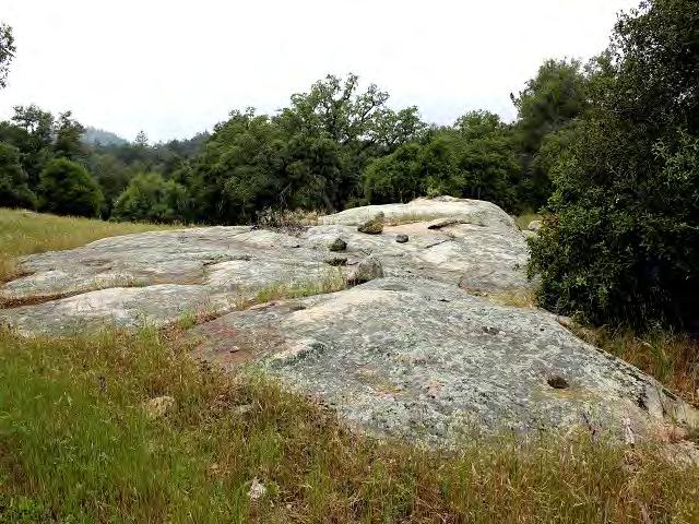
1 PROPERTY REPORT ADDRESS: 0 Black Mountain Truck Trail, Santa Ysabel, CA DESCRIPTION: lush desirable acres! Located in one of the most desired backcountry communities in Southern California, spans this beauty lush acres off of Black Mountain Truck Trail in Mesa Grande! Accessed through a gated entry and situated between soft meadows and beautiful, varied terrain, this pristine property is a beautiful visual description of some of the most sought-after acreage on Mesa Grande! Nearly all usable acreage, this partially fenced, flat and gently sloped landscape is a dream property complete with a water well and electricity! PRICE: $450,000 APN: MLS: CONTACT: Donn Bree; Donn@Donn.com;


2 36.88 Lush Desirable Acres! Located in one of the most desired backcountry communities in Southern California, spans this beauty lush acres off of Black Mountain Truck Trail in Mesa Grande! Accessed through a gated entry and situated between soft meadows and beautiful, varied terrain, this pristine property is a beautiful visual description of some of the most sought-after acreage on Mesa Grande! Nearly all usable acreage, this partially fenced, flat and gently sloped landscape is a dream property complete with a water well and electricity! Amongst the soft meadows, this property is teeming with its beautiful native foliage and various rock outcroppings. What makes this landscape so desirable is its usability, easy and gentle access and the picturesque topography that lends itself to multiple, supreme building sites. A rare property and priced to sell quickly. For more information, please contact us:


3

4 Donn Bree, Ph.D., G.R.I. POB 188 Santa Ysabel, CA PROPERTY DESCRIPTION Mesa Grande Acreage Black Mountain Truck Trail Santa Ysabel, CA Page: 1 of 2
5 Donn Bree, Ph.D., G.R.I. POB 188 Santa Ysabel, CA INTRODUCTION & OVERVIEW Lush Desirable Acres! Located in one of the most desired backcountry communities in Southern California, spans this beauty lush acres off of Black Mountain Truck Trail in Mesa Grande! Accessed through a gated entry and situated between soft meadows, and beautiful, varied terrain, this pristine property is a beautiful visual description of some of the most sought-after acreage on Mesa Grande! Nearly all usable acreage, this partially fenced, flat and gently sloped landscape is a dream property complete with a water well and electricity! The property is located off of Black Mountain Truck Trail. The Mesa Grande area is known for its beauty and proximity to a variety of recreational options, including the nearby Warner Springs Ranch and Santa Ysabel Preserve, in addition to Lake Henshaw. NATURAL SETTING The surrounding area is sparsely populated with large ranches blending into a landscape of rolling hills. Wildlife is abundant in the area: deer and turkey, bobcats and fox roam freely, while raptors and other rare species of animals can still be found here because of the abundance of water and cover in this rural area. AREA INFORMATION Agriculture is still the dominant economic activity in the Santa Ysabel area. Horse and cattle ranches are the backdrop for the landscape of light residential development. Gaming and tourism are important financial contributors, signaling the transition from agriculture into a more varied and stable economic base in the immediate area. There are many fine restaurants and lodging accommodations in the surrounding area of this centrally, yet privately located property. This beautiful site is located a short distance off of State Highway 76, with major shopping about 20 minutes driving time. Recreation & Lifestyle There are many recreational activities available in the area: The California Riding and Hiking Trail and the Pacific Crest Trail for riding, golfing at Warner s Ranch - which is presently undergoing a 50-milliondollar renovation, and Borrego Springs, hunting and fishing, dining, wine tasting along the nearby San Diego-Temecula wine country corridor, and a variety of other opportunities for each family member. The newly opened Santa Ysabel Open Space Preserve offers excellent riding trails connecting the Santa Ysabel, Wynola, and Julian communities. The famous Hale Observatory on Palomar Mountain is less than 30 minutes away. Page: 2 of 2

6

7 Disclaimer: This report is completed on a regional level with conservative data. The information provided is to be used as screening criteria only. All data is subject to review and may be verified through project site visits. This report may also include user generated static output from an internet mapping site. The information in this preliminary report may or may not be accurate, current, or reliable and may need to be changed on the basis of a more specific review. Report Run Date/Time: 5/6/ :44:03 PM Project Manager: Land Development Manager: Project Record ID: Project Environmental Review (ER) ID: Assessor's Parcel Number(s): Project Name: General Information USGS Quad Name/County Quad Number: Mesa Grande/44 Section/Township/Range: 29/11S/02E Tax Rate Area: Thomas Guide: 1093/0 Site Address: 0 Black Mountain Truck Trl Ramona Parcel Size (acres): Board of Supervisors District: 5 Water/Irrigation District: Public Service and Utility Districts ne Sewer District: Fire Agency: ne ne School District: Gen Elem Julian Union; High Julian Union 1 of 5
8 General Plan Regional Category: General Plan Land Use Designation: General Plan Information Rural Rural Lands (Rl-80) 1 Du/80 Ac Community Plan: rth Mountain Rural Village Boundary: Village Boundary: Special Study Area : ne ne ne Zoning Information Use Regulation: A72 Animal Regulation: O Density: - Minimum Lot Size: 8Ac Maximum Floor Area Ratio: - Floor Area Ratio: - Building Type: C Height: G Setback: C Lot Coverage: - Open Space: - Special Area Regulations: - The site is located within one mile of a State Scenic Highway. The site contains steep slopes > 25%. The site is located within Dark Skies "Zone A". Aesthetic Agricultural Resources The site is a Farmland Mapping and Monitoring Program (FMMP) designated farmland. The site contains Prime Soils. There is evidence of active agriculture on the project site. Please Refer To Aerial Imagery Sunset Zone: 18 The site is located within an Agricultural Preserve. The site is in a Williamson Act Contract. 2 of 5
9 Eco-Region: Biological Resources rthern Mountains Vegetation Map rthern Mixed Chaparral; Foothill/Mountain Perennial Grassland; Dense Engelmann Oak Woodland; Mixed Oak Woodland The site may contain rare/listed plants and animals found in the Sensitive Species matrix. The site is located within a Quino Checkerspot Butterfly Survey Area. The site contains Wetlands. The site is within one mile of Biological Easements. The site is within one mile of Multiple Species Conservation Program (MSCP) Pre- (Draft: East) Approved Mitigation Area (PAMA). The site is within MSCP Boundaries. The site is outside of MSCP and within 500 feet of: Coastal Sage Scrub Maritime Succulent Scrub Diegan Coastal Sage Scrub Inland Form (>1,000 ft. elevation) Coastal Sage - Chaparral Scrub Flat-Topped Buckwheat/Montane Buckwheat Scrub ne of the above The site is located within the rth County Habitat Evaluation Map. If yes, list the Habitat Value. The site is located within the Ramona Grassland area. The site is located within three miles of a National Wildlife Refuge. If yes, list the name of the Refuge. (Draft: East) Geological Formation: Cultural and Paleontological Resources (*always confirm with Cultural and Paleontology Specialists) Cretaceous Plutonic Paleo Sensitivity: Paleo Monitoring: Zero Monitoring Required Alquist-Priolo Zone: County Special Study Zone: Quaternary/Pre-Quaternary Fault: Potential Liquefaction Area: Soils Hydrologic Group: The site is located in a Landslide Susceptibility Area. If yes, list the Landslide Category. The site is located within a High Shrink Swell Zone (Expansive Soil). The site is located within an area categorized as high or moderate potential for unique geologic features. If yes, name the unique geologic features. Geology C : 3 of 5
10 The site is located within a Mineral Resource Category Mineral Resources Mrz ( Alluvium/ Mines) The site is located within a FEMA flood area. The site is located within 1/2 mile from a FEMA flood area. The site is located within a County Flood Plain area. The site is located within 1/2 mile from a County Flood Plain area. The site is located within a County Floodway. The site is located within 1/2 mile from a County Floodway. The site is located within a Dam Inundation Zone. Hazard Flooding Hazardous Materials Schools are located within 1/4 mile of the project. The site is located on or within 250 feet of the boundary of a parcel containing a historic waste disposal/burn site. The site is located within one mile of a property that may contain military munitions (UXO- Unexploded Ordnance). The site is located within 1000 feet of buried waste in a landfill. The site is listed in the Hazardous Material Establishment Listing. If yes, list name, establishment number, and permit number. The site is located within 2000 feet of a listing in DTSC's Site Mitigation and Brownfields Reuse Program Database ("CalSites" EnviroStor Database). The site is listed on the Geotracker listing. The site is listed on the Resource Conservation and Recovery Act Information (RCRAInfo) listing for hazardous waste handlers. The site is listed in the EPA's Superfund CERCLIS database. The site shows evidence that prior agriculture, industrial use, or a gas station or vehicle repair shop existed onsite. The site contains existing homes or other buildings constructed prior to Please Refer To Aerial Imagery Please Refer To Aerial Imagery The site is located in a FAA tification Zone. If yes, list the height restrictions. Airport Hazards The site (or portion of the site) is located within an Airport Influence Area. If yes, list the name of the airport. The site is located within an airport safety zone. If yes, list the zone number. The site is located within an Airport Land Use Compatibility Plan Area (Z.O. Section 5250, "C" Designation). The site is within one mile of a private airport. If yes, list the name of the airport. : Loma Madera Ranch 4 of 5
11 Hydrologic Unit: Sub-basin: The site is tributary to an already impaired waterbody, as listed on the Clean Water Act Section 303(d) list? If yes, list the impaired waterbody. The site is tributary to an Environmentally Sensitive Area. The site is located in a Source Water Protection Area Hydrology and Water Quality San Dieguito /Pamo : Pacific Ocean Shoreline (San Dieguito Hu); San Dieguito River; Lake Hodges The site is located outside (east) of the County Water Authority boundary. The site is in Borrego Valley. The project is groundwater dependent. Annual rainfall: The site is within noise contours. The site is located in an Urban-Wildland Interface Zone. FRA/LRA/SRA: The site is located within 150 feet of Mexican Border. The site is located within a Resource Conservation Area. The site is located in a Special Area. There are existing or proposed trails on site or adjacent properties. The site is located in an urbanized area as defined by the U.S. Census Bureau. The population has a density of 1,000 per square mile or greater. The site APN is listed in the GP Housing Element inventory. Water Supply/Groundwater 21 To24Inches ise Fire Services Sra Additional Information The site is located in the Desert. The site is located east of the County Water Authority boundary. All or a portion of the site is east of the Tecate Watershed Divide. The site is located immediately adjacent to a State Highway or Freeway. The site is located south of State Highway 78. The site is located in the Coastal Zone requiring a Coastal Development Permit. The site is located in the Sweetwater Basin. The site is located within 2640 feet (1/2 mile) of the Cleveland National Forest. There are State Parks that are located within 1/2 mile of the site, or may be substantially affected by the project. If yes, list the name of State Park(s). CEQA-Public Review Distribution Matrix 5 of 5
12 SOIL DESCRIPTION CAP CLASS STORIE INDEX SHRINK/SWELL EROSION INDEX HnE Holland stony fine sandy loam, 5 to 30 percent slopes 6e-7(20) 32 Moderate Severe 16
13 MSCP ANGEL MOU NT AIN RD PRIVATE RD PRIVATE RD ± MESA GRA NDE TRUCK T RL PRIVATE RD PRIVATE RD ME SA GRANDE RD QUAIL SPRINGS R D P RIVA TE RD Legend: PROJECT AREA EMSCP (DRAFT) DESCRIPTION Agriculture or Natural Upland within FCA County Owned Preserves Agriculture or Natural Upland outside FCA Riparian/Wetland Habitat and Transition Zone within FCA Riparian/Wetland Habitat and Transition Zone outside of FCA RMS 1 - Highest Level of Ecological Protection RMS 2 - Land managed with Ecological Protection RMS 3 - Land managed as Open Space RMS 4 - Other Public/Semi-Public Lands Developed Lands Tribal Lands BLACK MOUNTAIN TRUCK TRL PRIV ATE R D BLACK CANYO N RD Miles NAD 1983 StatePlane California VI FIPS 0406 Feet Planning and Development Services ± This map is generated automatically from an internet mapping site and is for reference only. Data layers that appear on this map may or may not be accurate, current, or otherwise reliable. THIS MAP IS NOT TO BE USED FOR NAVIGATION. tes: MSCP = Multiple Species Conservation Program

14

15
16
17 A72 GENERAL AGRICULTURAL USE REGULATIONS 2720 INTENT. The provisions of Section 2720 through Section 2729, inclusive, shall be known as the A72 General Agricultural Use Regulations. The A72 Use Regulations are intended to create and preserve areas for the raising of crops and animals. Processing of products produced or raised on the premises would be permitted as would certain commercial activities associated with crop and animal raising. Typically, the A72 Use Regulations would be applied to areas distant from large urban centers where the dust, odor, and noise of agricultural operations would not interfere with urban uses, and where urban development would not encroach on agricultural uses PERMITTED USES. The following use types are permitted by the A72 Use Regulations: a. Residential Use Types. Family Residential b. Civic Use Types. Essential Services Fire Protection Services (see Section 6905) Law Enforcement Services (see Section 6905) c. Agricultural Use Types. Horticulture (all types) Tree Crops Row and Field Crops Packing and Processing: Limited Packing and Processing: Wholesale Limited Winery (Amended by Ord (N.S.) adopted ) (Amended by Ord (N.S.) adopted ) (Amended by Ord (N.S.) adopted ) (Amended by Ord (N.S.) adopted ) (Amended by Ord (N.S.) effective (Urg. Ord.)) (Amended by Ord (N.S.) adopted ) (Amended by Ord (N.S.) adopted ) 2723 PERMITTED USES SUBJECT TO LIMITATIONS. The following use types are permitted by the A72 Use Regulations subject to the applicable provisions of Section The number in quotes following the use type refers to the subsection of Section 2980 which applies. a. Residential Use Types Mobile home Residential "18" b. Commercial Use Types Animal Sales and Services: Veterinary (Large Animals) "6" Animal Sales and Services: Veterinary (Small Animals) "6" Cottage Industries "17" (see Section 6920) Recycling Collection Facility, Small "2" Recycling Processing Facility, Wood and Green Materials "3" c. Agricultural Use Types Packing and Processing: Boutique Winery "22" (see Section 6910) (Amended by Ord (N.S.) adopted )
18 (Amended by Ord (N.S.) adopted ) (Amended by Ord (N.S.) adopted ) (Amended by Ord (N.S.) adopted ) (Amended by Ord (N.S.) adopted ) (Amended by Ord (N.S.) adopted ) (Amended by Ord (N.S.) adopted ) 2724 USES SUBJECT TO A MINOR USE PERMIT. The following use types are permitted by the A72 Use Regulations upon issuance of a Minor Use Permit. a. Residential Use Types. Farm Labor Camps (See Section 6906); except that a Minor Use Pemiit shall not be required for a Farm Labor Camp for which a Use Permit is prohibited under Section or Section of the California Health and Safety Code. b. Civic Use Types. Minor Impact Utilities Small Schools (Amended by Ord (N.S.) adopted ) (Amended by Ord (N.S.) adopted ) (Amended by Ord (N.S.) adopted ) (Amended by Ord (N.S.) effective (Urg. Ord.)) (Amended by Ord (N.S.) adopted ) (Amended by Ord (N.S.) adopted ) (Amended by Ord (N.S.) adopted ) (Amended by Ord (N.S.) adopted ) (Amended by Ord (N.S.) adopted ) 2725 USES SUBJECT TO A MAJOR USE PERMIT. The following use types are permitted by the A72 Use Regulations upon issuance of a Major Use Permit. a. Residential Use Types. Group Residential b. Civic Use types. Administrative Services Ambulance Services Child Care Center Clinic Services Community Recreation Cultural Exhibits and Library Services Group Care Lodge, Fraternal and Library Services Major Impact Services and Utilities Parking Services Postal Services Religious Assembly c. Commercial Use Types. Agricultural and Horticultural Sales (all types) Animal Sales and Services: Auctioning Explosive Storage (see Section 6904) Gasoline Sales
19 Participant Sports and Recreation: Outdoor Transient Habitation: Campground (see Section 6450) Transient Habitation: Resort (see Section 6400) d. Agricultural Use Types. Agricultural Equipment Storage Animal Waste Processing (see Section 6902) Packing and Processing: Winery Packing and Processing: General Packing and Processing: Support e. Extractive Use Types. Mining and Processing (see Section 6550) (Amended by Ord (N.S.) adopted ) (Amended by Ord (N.S.) adopted ) (Amended by Ord (N.S.) adopted ) (Amended by Ord (N.S.) adopted ) (Amended by Ord (N.S.) adopted ) (Amended by Ord (N.S.) adopted )
PROPERTY REPORT. ADDRESS: 0 Highway 78, Ramona, CA DESCRIPTION: Incredible view property! Located high up on the hilltop, near the Golden Eagle
 PROPERTY REPORT ADDRESS: 0 Highway 78, Ramona, CA 92065 DESCRIPTION: Incredible view property! Located high up on the hilltop, near the Golden Eagle Thoroughbred Farm in eastern Ramona s, Ballena Valley,
PROPERTY REPORT. ADDRESS: Hwy 76, Pauma Valley, CA 92061
 PROPERTY REPORT ADDRESS: 20083 Hwy 76, Pauma Valley, CA 92061 DESCRIPTION: Rare, affordable horse property on 3+ acres with 1 bd, 1 ba home in desirable Cuca Ranch! This 3.58-acre fully usable parcel offers
PROPERTY REPORT. ADDRESS: 3803 Wynola Rd., Julian, CA 92036
 PROPERTY REPORT ADDRESS: 3803 Wynola Rd., Julian, CA 92036 DESCRIPTION: Beautiful, custom home on 2.5 acres in the welcoming community of Wynola. Formerly a working apple orchard, the property includes
PROPERTY REPORT DESCRIPTION:
 PROPERTY REPORT DESCRIPTION: Remarkable opportunity for discovery awaits at this exclusive 376+ acre estate, nestled high above one of Southern California s most highly sought-after metropolitan areas.
PROPERTY REPORT. ADDRESS: 0 Silver Cloud Pass, Julian, CA 92036
 PROPERTY REPORT ADDRESS: 0 Silver Cloud Pass, Julian, CA 92036 DESCRIPTION: Forever views await at this stunning 12 acre hilltop property located in the desirable Pine Hills area of Julian. Breathtaking
South Mesa Drive. Offered At $750,000. Address: South Mesa Drive Pauma Valley, CA APN #:
 South Mesa Drive Address: 17562 South Mesa Drive Pauma Valley, CA 92061 Offered At $750,000 APN #: 132 170 44-00 Description: Lovely custom built three-bedroom, three-bath home with alternate fourth room
SUTTER COUNTY. General Plan Update Technical Background Report
 SUTTER COUNTY General Plan Update Technical Background Report February 2008 SUTTER COUNTY GENERAL PLAN UPDATE TECHNICAL BACKGROUND REPORT PREPARED FOR: SUTTER COUNTY PREPARED BY: PBS&J IN PARTNERSHIP
2.0 Physical Characteristics
 _ 2.0 Physical Characteristics 2.1 Existing Land Use for the Project The site is comprised of approximately 114 acres bounded by Highway 101 to the north, the existing town of Los Alamos to the east, State
Roduner Ranch FOR SALE. 5,878± Acres Potential Development Land. Merced County, California. Offices Serving The Central Valley
 FOR SALE 5,878± Acres Potential Development Land Merced County, California Offices Serving The Central Valley F R E S N O V I S A L I A B A K E R S F I E L D 7480 N. Palm Ave, Ste 101 3447 S. Demaree Street
BROCHURE. APPLE HILL WOODS 118 +/- Acres Camino, California. Presented by Jim Copeland
 BROCHURE APPLE HILL WOODS 118 +/- Acres Camino, California Presented by Jim Copeland 1 The Property This 118 acre is a rare gem in the Sierra Nevada foothills. Covered with lush forestland and scattered
STORNETTA BROTHERS COASTAL RANCH
 STORNETTA BROTHERS COASTAL RANCH Location: Surrounding Point Arena Lighthouse and immediately south of Manchester State Park Mendocino Co., CA Acres: 1,860 Resources: Over two miles of Pacific Ocean coastline
Town of Oakfield Agricultural and Farmland Protection Plan
 SECTION III COMMUNITY OVERVIEW A. Regional Setting / Location The Town of Oakfield is located in the northwestern portion of Genesee County. Located west of New York's Finger Lakes, the Town is uniquely
Airport Land Use Compatibility Plan (ALUCP) Update. Public Information Meeting #4 June 8 & 9, 2016
 Update. Public Information Meeting #4 June 8 & 9, 2016") Airport Land Use Compatibility Plan (ALUCP) Update Public Information Meeting #4 June 8 & 9, 2016 Agenda 1. Study Process 2. Noise Complaint Patterns 3. Proposed Overflight Areas (AOA) 4. Proposed Land
Airport Land Use Compatibility Plan (ALUCP) Update Public Information Meeting #4 June 8 & 9, 2016 Agenda 1. Study Process 2. Noise Complaint Patterns 3. Proposed Overflight Areas (AOA) 4. Proposed Land
b. Minimum Site Area. Recreational vehicle parks shall be located on a parcel of land not less than 3 acres in area.
 6450 RECREATIONAL VEHICLE PARK REGULATIONS 6450 TITLE AND PURPOSE. The provisions of Section 6450 through 6499, inclusive, shall be known as the Recreational Vehicle Park Regulations. The purpose of these
BROCHURE Sierra Foothills Ranch 55 Acres Pilot Hill, California. Presented by Jim Copeland
 BROCHURE Sierra Foothills Ranch 55 Acres Pilot Hill, California Presented by Jim Copeland 1 The Property This 55 acres is located midway between the historic California gold rush towns of Placerville and
WORKSHEET 1 Wilderness Qualities or Attributes Evaluating the Effects of Project Activities on Wilderness Attributes
 WORKSHEET 1 Wilderness Qualities or Attributes Evaluating the Effects of Project Activities on Wilderness Attributes Date: 3/7/2017 Roadless Area: Ruby South Description of Project Activity or Impact to
David Magney Environmental Consulting
 David Magney Environmental Consulting DELINEATION OF JURISDICTIONAL WATERS AND RIPARIAN HABITATS FOR LYONS CANYON RANCH, NEWHALL, CALIFORNIA Prepared for: UNITED STATES ARMY CORPS OF ENGINEERS and CALIFORNIA
Morgan Estates. Lassen County, CA. Proudly Offered By
 Morgan Estates Lassen County, CA Proudly Offered By 707 Merchant Street, Suite 100, Vacaville, Ca 95688 (707) 455-4444 Office (707) 455-0455 Fax info@caoutdoorproperties.com Introduction Looking North
Table 1: Santiago Peak Communication Site. Latitude 1 Longitude 1 Elev 2 Address T/R/S 3 APN 4 USGS Quadrangle
 County of Riverside Public Safety Enterprise Communication Project Appendix A: Candidate Site Descriptions Overview The site is located in the Cleveland National Forest (CNF) at an existing communication
Bradley Brook Relocation Project. Scoping Notice. Saco Ranger District. United States Department of Agriculture Forest Service
 Bradley Brook Relocation Project United States Department of Agriculture Forest Service Scoping Notice White Mountain National Forest February 2011 For Information Contact: Jenny Burnett White Mountain
Double Bar Z Ranch 8,690 ± California. Mariposa County Exclusive Agents Allen Alsobrook Jim Watson. Sierra Foothills. La Grange
 Double Bar Z Ranch 8,690 ± California. Mariposa County Exclusive Agents Allen Alsobrook Jim Watson Sierra Foothills. La Grange The Double Bar Z Ranch is a spectacular working cattle ranch. It has been
THE OLSEN RANCH. Paso Robles, California 600+ UNIT PLANNED COMMUNITY DEVELOPMENT OPPORTUNITY. << Click to View Aerial Tour >>
 THE OLSEN RANCH Paso Robles, California 600+ UNIT PLANNED COMMUNITY DEVELOPMENT OPPORTUNITY > OLSEN RANCH TABLE OF CONTENTS OFFERING OVERVIEW... 3 PROPERTY PHOTOS...10 MAPS
Welcome Land Use Element... LU-1
 Welcome Land Use Element... LU-1 Land Use Plan... LU-3 Residential Land Uses... LU-12 Commercial Land Uses... LU-14 Mixed Use... LU-16 Industrial Land Uses... LU-18 Automobile-Related Land Uses... LU-19
ROAD AND TRAIL PROJECT APPROVAL
 ROAD AND TRAIL PROJECT APPROVAL www.marincountyparks.org Marin County Parks, 3501 Civic Center Dr, Suite 260, San Rafael, CA 94903 DATE: July 12, 2017 PRESERVE: Gary Giacomini Open Space Preserve PROJECT:
BROCHURE Pilot Hill Ranch 304 Acres +/- Pilot Hill, CA. Presented by Jim Copeland
 BROCHURE Pilot Hill Ranch 304 Acres +/- Pilot Hill, CA Presented by Jim Copeland 1 The Property This gently rolling 304 acres of ranchland is located in Pilot Hill, midway between the historic California
Sunrise Ranch 6890 acres, Jeff Davis County, Texas On the Fort Davis Scenic Loop
 Sunrise Ranch 6890 acres, Jeff Davis County, Texas On the Fort Davis Scenic Loop 432-386-2821 Cell 432-426-2024 Office james@kinglandwater.com King Land & Water LLC P.O. Box 109, 600 State Street, Fort
Eagle Pinon Ranch. 2,963 +/- acres, Hudspeth County
 Eagle Pinon Ranch 2,963 +/- acres, Hudspeth County Eagle Piñon Ranch 2963 acres Hudspeth County, Texas Location The Eagles are part of a chain of sky island mountains that stretch from New Mexico through
SUMMER VILLAGE OF SILVER SANDS. Municipal Development Plan
 SUMMER VILLAGE OF SILVER SANDS Municipal Development Plan Bylaw 253-2014 Adopted August 22, 2014 Summer Village of Silver Sands Municipal Development Plan Bylaw No. 253-2014 Page 2 1 INTRODUCTION 1.1 SETTING
Theme: Predominately natural/natural appearing; rustic improvements to protect resources. Size*: 2,500 + acres Infrastructure**:
 Recreation Opportunity Spectrum (ROS) Classes The Recreation Opportunity Spectrum (ROS) provides a way to describe the variations in the degree of isolation from the sounds and influences of people, and
Map 1.1 Wenatchee Watershed Land Ownership
 Map 1.1 Wenatchee Watershed Land Ownership Map 1.1 Wenatchee Watershed Land Ownership The Wenatchee watershed lies in the heart of Washington state in Chelan County. Just larger than the state of Rhode
II. GENERAL DESCRIPTION OF ENVIRONMENTAL SETTING
 II. GENERAL DESCRIPTION OF ENVIRONMENTAL SETTING A. LOCATION AND BOUNDARIES The proposed Canyon Hills project site is located at 8000 West La Tuna Canyon Road in the City of Los Angeles (the City ). The
Flying Cloud Airport (FCM) Zoning Process: Informing a Mn/DOT Path Forward
 Zoning Process: Informing a Mn/DOT Path Forward") : Informing a Mn/DOT Path Forward A Review of the Flying Cloud Airport (FCM) Joint Airport Zoning Board (JAZB) Process and the Draft Airport Zoning Ordinance B A RPZ RPZ A B C Zone Chad E. Leqve Director
: Informing a Mn/DOT Path Forward A Review of the Flying Cloud Airport (FCM) Joint Airport Zoning Board (JAZB) Process and the Draft Airport Zoning Ordinance B A RPZ RPZ A B C Zone Chad E. Leqve Director
PUBL DRAFT. MISSION TRAILS REGIONAL PARK 3.7. West Sycamore 3-87
 MISSION TRAILS REGIONAL PARK 3.7. West Sycamore The West Sycamore area is bounded by residential uses on the west, the two-lane Sycamore Canyon Road on the north, Goodan Ranch Sycamore Canyon Preserve
Table 1: Avocado Flats Communication Site. Latitude 1 Longitude 1 Elev 2 Address T/R/S 3 APN 4 USGS Quadrangle
 County of Riverside Public Safety Enterprise Communication Project Appendix A: Candidate Site Descriptions Overview The candidate area is located in Northern San Diego County, 0.65 mile south of the border
AMENDMENT NO. 03 TO THE OFFICIAL PLAN FOR THE TOWNSHIP OF ADJALA-TOSORONTIO OAK RIDGES MORAINE CONSERVATION PLAN
 AMENDMENT NO. 03 TO THE OFFICIAL PLAN FOR THE TOWNSHIP OF ADJALA-TOSORONTIO OAK RIDGES MORAINE CONSERVATION PLAN Adopted by Council July 19 th, 2004 Approved with modifications by the Province of Ontario
NAVAJO COMMUNITY PLAN
 NAVAJO COMMUNITY PLAN Prepared by the NAVAJO COMMUNITY PLANNERS and THE CITY OF SAN DIEGO City of San Diego Planning Department 202 C Street, MS 4A San Diego, CA 92101 Printed on recycled paper. This information,
Brinker Creek Ranch. Colorado - Routt County - Yampa
 Located at the base of the Flattops Range in the Steamboat/Vail corridor, Brinker Creek Ranch consists of 1,451 acres ideally suited for high country grazing and native grass hay production. Traditionally
BUCK POINT RANCH. Aspen Associates Realty
 BUCK POINT RANCH Aspen Associates Realty www.aspenassociatesrealty.com 970.544.5800 WELCOME TO Buck Point Ranch is a 960± acre property located in one of the last pristine valleys in close proximity to
Wool Ranch 20 Acres 20 +/- acres Sunol, CA Alameda County
 Wool Ranch 20 Acres 20 +/- acres Sunol, CA Alameda County 707 Merchant Street Suite 100 Vacaville, CA 95688 707-455-4444 Office 707-455-0455 Fax californiaoutdoorproperties.com CalBRE# 01838294 Introduction
Alternative 3 Prohibit Road Construction, Reconstruction, and Timber Harvest Except for Stewardship Purposes B Within Inventoried Roadless Areas
 Roadless Area Conservation FEIS Summary Table S-1. Comparison of Key Characteristics and Effects by Prohibition Alternative. The effects summarized in this table A would occur in inventoried roadless areas
PLANNING CONSIDERATIONS
 12TH NOGALES PARK TUCSON ALVERNON SWAN WILMOT CAMPBELL DREXEL COUNTRY CLUB LEGEND RESERVE LAND AREA (APPROXIMATE) POTENTIAL FUTURE HSR TO AIRPORT TRANSIT CONNECTIONS VALENCIA PIMA COUNTY CITY OF TUCSON
Blueways: Rivers, lakes, or streams with public access for recreation that includes fishing, nature observation, and opportunities for boating.
 Parks, Open Space and Trails PRINCE WILLIAM COUNTY 2008 COMPREHENSIVE PLAN TRAILS PLAN CONTENTS The components of the trails plan are: Intent Definitions Goals, Policies, and Action Strategies Trails Map
Environmental Development of River Road Ranch
 Environmental Development of River Road Ranch New Braunfels, Texas Alix Scarborough GEO 3426 April 2012 Introduction The 2,400-acre Word-Borcher ranch has been owned by the Word family since 1941. Located
The following criteria shall be applied within the boundaries of the AO District:
 Sec. 419 (a) Purpose AIRPORT OVERLAY DISTRICT (AO) The purpose of the Airport Overlay District is to regulate and restrict the height of structures, objects, or natural growth, regulate the locations of
Preliminary Site Evaluation
 Preliminary Site Evaluation 100 Acre Site, US 72 Piperton, Tennessee Power Distributor: Chickasaw Electric Cooperative August 2010 SITE DATA SHEET PIPERTON US 72 SITE (100 ACRES): LOCATION & GENERAL DESCRIPTION
Appendix I. Wilderness Review
 Appendix I. Wilderness Review This appendix contains the wilderness inventory conducted for the Ash Meadows, Moapa Valley, and Pahranagat National Wildlife Refuges (NWRs) as part of the Comprehensive Conservation
MONTEREY REGIONAL AIRPORT MASTER PLAN TOPICAL QUESTIONS FROM THE PLANNING ADVISORY COMMITTEE AND TOPICAL RESPONSES
 MONTEREY REGIONAL AIRPORT MASTER PLAN TOPICAL QUESTIONS FROM THE PLANNING ADVISORY COMMITTEE AND TOPICAL RESPONSES Recurring topics emerged in some of the comments and questions raised by members of the
HEADQUARTERS WEST LTD. PHOENIX - TUCSON - SONOITA - COTTONWOOD - ST. JOHNS
 Offered for sale exclusively by: Walter Lane Headquarters West, Ltd. PO BOX 37018 Tucson, AZ 85740 Phone (520) 792-2652 info@headquarterswest.com www.headquarterswest.com General Area Description The Crown
Chapter 2: El Dorado County Characteristics and Demographics
 Chapter 2: El Dorado County Characteristics and Demographics 2.1 Geographic Area and Demographics El Dorado County comprises 1,805 square miles with over half of the area in the Eldorado National Forest
BROCHURE Pilot Hill Meadows Acres Pilot Hill, California. Presented by Jim Copeland
 BROCHURE Pilot Hill Meadows 58.09 Acres Pilot Hill, California Presented by Jim Copeland 1 The Property This 58 acres is a portion of the 304 acre Pilot Hill Ranch in Pilot Hill and is a separate legal
KNIGHTS LANDING RIVER RANCH WOODLAND, CA - YOLO COUNTY
 PROPERTY HIGHLIGHTS ±77.2 Gross Acres Contains Excellent Sandy and Silty Clay Loam Soils Established Surface Water Rights in Sacramento River Developed River Diversion and Distribution System Three Phase
Bat Cave Canyon Ranch 2,920 acres Jeff Davis County, Texas
 Bat Cave Canyon Ranch 2,920 acres Jeff Davis County, Texas James King, Agent Office 432.426.2024 Cell 432.386.2821 James@KingLandWater.com Bat Cave Canyon Ranch 2,920 acres Jeff Davis County, Texas James
FOR SALE Wallner Ranch
 FOR SALE Wallner Ranch 857± Acres Mariposa County, California Exclusively Presented By: Pearson Realty Year round livestock grazing Abundant wildlife Great recreational property CA BRE #00020875 Wallner
Table 1: Margarita (SDSU) Communication Site. Latitude 1 Longitude 1 Elev 2 Address T/R/S 3 APN 4 USGS Quadrangle
 Communication Site. Latitude 1 Longitude 1 Elev 2 Address T/R/S 3 APN 4 USGS Quadrangle") County of Riverside Public Safety Enterprise Communication Project Appendix A: Candidate Site Descriptions Margarita (SDSU) Communication Site Margarita (SDSU) Communication Site Overview The site is located
County of Riverside Public Safety Enterprise Communication Project Appendix A: Candidate Site Descriptions Margarita (SDSU) Communication Site Margarita (SDSU) Communication Site Overview The site is located
PREMIER CARDIFF DEVELOPMENT OPPORTUNITY 17.5 GROSS ACRES
 Views / Ocean Views from Top Portion of Site Zoned RR-2 (21,500 SF Minimum Lot Size) City of Encinitas Jurisdiction One of the Last Premier Undeveloped Large Parcels of Land in San Diego County Submit
5.0 OUTDOOR RECREATION OPPORTUNITIES AND MANAGEMENT
 5.0 OUTDOOR RECREATION OPPORTUNITIES AND MANAGEMENT 5.1 Introduction This section describes the range of recreational activities that currently take place in Marble Range and Edge Hills Parks, as well
Acres Monterey County, California OPEN GROUND IN SALINAS VALLEY VEGETABLE AND STRAWBERRY PROPERTY
 324 +- Acres Monterey County, California OPEN GROUND IN SALINAS VALLEY VEGETABLE AND STRAWBERRY PROPERTY EXCLUSIVELY PRESENTED BY: Morris Garcia License 00834407 (559) 994-7453 Cell Sarah Donaldson License
FEASIBILITY CRITERIA
 This chapter describes the methodology and criteria used to evaluate the feasibility of developing trails throughout the study areas. Land availability, habitat sensitivity, roadway crossings and on-street
Maya s Creek Crossing Hwy 17 N acres $185,000 Fort Davis, Texas
 Maya s Creek Crossing Hwy 17 N 14.98 acres $185,000 Fort Davis, Texas James King, Agent Office 432-426-2024 Cell 432-386-2821 James@KingLandWater.com King Land & Water LLC P.O. Box 109, 600 State Street,
Our Mission. Discover the many states of California. Chino Hills State Park 1879 Jackson Street Riverside, Ca (951)
") Chino Hills State Park Our Mission The mission of the California Department of Parks and Recreation is to provide for the health, inspiration and education of the people of California by helping to preserve
Chino Hills State Park Our Mission The mission of the California Department of Parks and Recreation is to provide for the health, inspiration and education of the people of California by helping to preserve
Washakie Wilderness Ranch
 Washakie Wilderness Ranch Dubois, Wyoming Fly Fishing Hunting Ranching Conservation Washakie Wilderness Ranch Dubois, Wyoming Introduction: A stunning 160-acre parcel located at the base of the Ramshorn
Creating a User-Driven Long-Distance OHV Trail Through Partnering
 Joseph Raffaele Outdoor Recreation Planner U.S. Bureau of Land Management Yuma, Arizona Creating a User-Driven Long-Distance OHV Trail Through Partnering BLM is a multiple-use land management agency within
HIGH COUNTRY L-BAR RANCH
 HIGH COUNTRY L-BAR RANCH Sandoval and mckinley counties N e w m e x i c o Jim Haworth, Ranch Team Lead Broker ~ 505-235-5236 3613 NMSR 528 NW, Ste. H, Albuquerque, NM 87114 505-792-3713 www.wwrealty.com
112th CONGRESS. 1st Session H. R. 113 IN THE HOUSE OF REPRESENTATIVES
 HR 113 IH 112th CONGRESS 1st Session H. R. 113 To provide for additions to the Cucamonga and Sheep Mountain Wilderness Areas in the Angeles and San Bernardino National Forests and the protection of existing
THE OLSEN RANCH. Paso Robles, California 600+ UNIT PLANNED COMMUNITY DEVELOPMENT OPPORTUNITY. << Click to View Aerial Tour >>
 THE OLSEN RANCH Paso Robles, California 600+ UNIT PLANNED COMMUNITY DEVELOPMENT OPPORTUNITY > OLSEN RANCH TABLE OF CONTENTS OFFERING OVERVIEW... 3 PROPERTY PHOTOS...10 MAPS
EAST VALLEY PARKWAY FOR SALE - RESIDENTIAL DEVELOPMENT OPPORTUNITY 3141 E. VALLEY PARKWAY ESCONDIDO, CA ACRE SITE $1,100,000
 3141 E. VALLEY PARKWAY ESCONDIDO, CA 92027-5219 3.31 ACRE SITE $1,100,000 OFFERING HIGHLIGHTS Valley High School Residential Development Opportunity Close to Frances Ryan Park & Multiple Schools Settled
CHAPTER III: TRAIL DESIGN STANDARDS, SPECIFICATIONS & PERMITS
 CHAPTER III Trail Design Standards, Specifications & Permits This chapter discusses trail standards, preferred surface types for different activities, permits, and other requirements one must consider
EXECUTIVE SUMMARY PROGRAM DEVELOPMENT REPORT PURPOSE EXISTING SETTING EXPANDING PARKLAND
 EXECUTIVE SUMMARY PROGRAM DEVELOPMENT REPORT PURPOSE As the culmination of the first phase of the master planning process, this Program Development Report creates the framework to develop the Calero County
Region 1 Piney Woods
 Region 1 Piney Woods Piney Woods 1. This ecoregion is found in East Texas. 2. Climate: average annual rainfall of 36 to 50 inches is fairly uniformly distributed throughout the year, and humidity and temperatures
Terrestrial Protected Area Nomination: Central Mangrove Wetland South-West, Grand Cayman
 Terrestrial Protected Area Nomination: Central Mangrove Wetland South-West, Grand Cayman The attached nomination, proposing that a parcel of land in the Central Mangrove Wetland be made a Protected Area
Great Wolf Lodge Fact Sheet & Frequently Asked Questions Potential Location in Gilroy, California 8/30/17
 WHAT? Great Wolf Resorts has identified Gilroy, California as a potential location for a new Great Wolf Lodge family resort and has entered into a 60-day period of exclusivity with the City and community
salisbury canyon - Ranch new cuyama, California
 Operations/ Recreation 100 Road New Cuyama, California Due to its rustic ambience, privacy, and pristine condition, Ranch (considered by many to be nicest ranch in Cuyama Valley) is a working cattle ranch.
FINAL TESTIMONY 1 COMMITTEE ON RESOURCES UNITED STATES HOUSE OF REPRESENTATIVES. July 13, 2005 CONCERNING. Motorized Recreational Use of Federal Lands
 FINAL TESTIMONY 1 STATEMENT OF DALE BOSWORTH CHIEF Of the FOREST SERVICE UNITED STATES DEPARTMENT OF AGRICULTURE Before the SUBCOMMITTEE ON FORESTS AND FOREST HEALTH And the SUBCOMMITTEE ON NATIONAL PARKS,
Table 1: Paradise Communication Site. Latitude 1 Longitude 1 Elev 2 Address T/R/S 3 APN 4 USGS Quadrangle
 County of Riverside Public Safety Enterprise Communication Project Appendix A: Candidate Site Descriptions Overview The site is located atop a west-facing ridge overlooking the City of Norco, approximately
MANAGEMENT DIRECTION STATEMENT June, 1999
 Thompson River District MANAGEMENT DIRECTION STATEMENT June, 1999 for Roche Lake Provincial Park Ministry of Environment Lands and Parks BC Parks Division Table of Contents I. Introduction A. Setting
BAsin. - Ranch - Offered at $11,500,000.
 BAsin Greenfield, California Offered at $11,500,000 www.clarkcompany.com 1031 Pine Street Paso Robles, California 93446 Phone: (805) 238-7110 Fax: (805) 238-1324 info@clarkcompany.com BAsin Description
Carson City Open Space APNs and , west of Deer Run Road bridge
 32 acres (See separate packet for information on this open space property) OPEN SPACE PROPERTY APNs 008-541-73 and 008-541-92 (north and south sides of the river) Morgan Mill Road River Access Area (parking
STAFF REPORT. Airport Land Use Plan Consistency Review: Old Town Village Mixed Use Project City of Goleta. MEETING DATE: June 18, 2015 AGENDA ITEM: 5M
 STAFF REPORT SUBJECT: Airport Land Use Plan Consistency Review: Old Town Village Mixed Use Project City of Goleta MEETING DATE: AGENDA ITEM: 5M STAFF CONTACT: Peter Imhof, Andrew Orfila RECOMMENDATION:
Mills Pecos River Ranch 7800 Acres Val Verde County, Texas Situated along both sides of the Pecos River
 Mills Pecos River Ranch 7800 Acres Val Verde County, Texas Situated along both sides of the Pecos River James King, Agent Office 432-426-2024 Cell 432-386-2821 James@KingLandWater.com King Land & Water
David Johnson. Tom, Attached please find the final scoping letter and figures for your review. David
 David Johnson From: Sent: To: Cc: Subject: Attachments: David Johnson Tuesday, April 12, 2011 4:33 PM Thomas Malecek Dave Dyer; Jason Marks (jmarks@segroup.com) VWC Scoping Letter
VI. ALTERNATIVES TO THE MASTER PLAN C. RENOVATED EAST BUILDING ALTERNATIVE
 VI. ALTERNATIVES TO THE MASTER PLAN C. RENOVATED EAST BUILDING ALTERNATIVE INTRODUCTION The Renovated East Building Alternative would include the continued use of the renovated West Building and the renovation
Vineyard Cattle Recreation. West Sacramento, CA 95691
 Casey Flat Ranch 5,250± acres in Guinda, California Vineyard Cattle Recreation For Sale $10,500,000 Casey Flat Ranch is one of Northern California s hidden gems located in the mountains along the west
Continental Divide National Scenic Trail Legislative History and Planning Guidance
 Continental Divide National Scenic Trail Legislative History and Planning Guidance Legislation, Policy, and Direction Regarding National Scenic Trails The National Trails System Act, P.L. 90-543, was passed
Airport Planning Area
 PLANNING AREA POLICIES l AIRPORT Airport Planning Area LOCATION AND CONTEXT The Airport Planning Area ( Airport area ) is a key part of Boise s economy and transportation network; it features a multi-purpose
Provincial Development and Physical Framework Plan Province of Capiz
 3.2.3 Protection Areas Protection areas (Map 11) which include areas under the categories of NIPAS, Non-NIPAS, environmentally constrained and the military reservations are described as follows: a) NIPAS
Rule Governing the Designation and Establishment of All-Terrain Vehicle Use Trails on State Land
 Rule Governing the Designation and Establishment of All-Terrain Vehicle Use Trails on State Land 1.0 Authority 1.1 This rule is promulgated pursuant to 23 V.S.A. 3506. Section 3506 (b)(4) states that an
Order of the Minister of Environment #39, August 22, 2011 Tbilisi
 Registration Code 360050000.22.023.016080 Order of the Minister of Environment #39, August 22, 2011 Tbilisi On preparatory stages and procedure of the methodology for Elaborating structure, content and
Treaty Oaks Ranch 323+/- Acres Hood County, Texas $1,776,500
 Bret Polk Mobile: (254) 965-0349 Office: (214) 361-9191 Treaty Oaks Ranch 323+/- Acres Hood County, Texas $1,776,500 LOCATION: The ranch is located in a desirable area 10+/- miles south of Granbury, Texas,
B HALL RANCH FISHTAIL, MONTANA
 Brochure Courtesy of: B HALL RANCH FISHTAIL, MONTANA w w w. m c c a s l i n l a n d. c o m Page 1 LOCATION The Hall Ranch is ideally located in the foothills of the Beartooth Mountains, approximately 5
1803 West Hwy 160 Monte Vista, CO (719) TTY (719)
 TTY (719)") USDA Forest Service Rio Grande National Forest http://www.fs.fed.us/r2/riogrande 1803 West Hwy 160 Monte Vista, CO 81144 (719)852-5941 TTY (719)852-6271 USDI Bureau of Land Management San Luis Valley Center
USDA Forest Service Rio Grande National Forest http://www.fs.fed.us/r2/riogrande 1803 West Hwy 160 Monte Vista, CO 81144 (719)852-5941 TTY (719)852-6271 USDI Bureau of Land Management San Luis Valley Center
Section 61 Recreational Vehicle Park / Campground (Bylaw No. 2012/10)
") Part 7 General Regulations Section 61 Recreational Vehicle Park / Campground (Bylaw No. 2012/10) 61.1 A comprehensive site plan shall be provided to the satisfaction of the Development Authority that shows
Part 7 General Regulations Section 61 Recreational Vehicle Park / Campground (Bylaw No. 2012/10) 61.1 A comprehensive site plan shall be provided to the satisfaction of the Development Authority that shows
Marchand Provincial Park. Management Plan
 Marchand Provincial Park Management Plan 2 Marchand Provincial Park Table of Contents 1. Introduction... 3 2. Park History... 3 3. Park Attributes... 4 3.1 Natural... 4 3.2 Recreational... 4 3.3 Additional
TAYLOR CANYON RANCH COLORADO - ROUTT COUNTY - STEAMBOAT SPRINGS
 TAYLOR CANYON RANCH COLORADO - ROUTT COUNTY - STEAMBOAT SPRINGS Tucked up against the steep valley shaped by Mt. Pau and rising to the Routt National Forest, Taylor Canyon Ranch is an easily accessible,
Appendix L Technical Memorandum Aesthetics
 Technical Memorandum Aesthetics 1.0 AESTHETICS This section provides a discussion of the aesthetic resources in the vicinity of ARTIC. Aesthetics pertain to the elements that make a certain view pleasing
Blanco Creek Ranch Acres, Uvalde County, Texas
 Blanco Creek Ranch 1208.30 Acres, Uvalde County, Texas James King, Agent Office 432 426.2024 Cell 432 386.2821 James@KingLandWater.com Blanco Creek Ranch 1208.30 acres Uvalde County, Texas James King,
Steps in the Management Planning Process
 Steps in the Management Planning Process Developing a management plan for Kalamalka Lake Park will follow a multi-stage process. The planning process for this park is currently in the Draft Management
Existing Resource Information
 Botanical and Wildlife Vegetation alliances/wildlife habitats Grasslands annual/perennial Chaparral mixed/montane/chamise-redshank Riparian montane/valley foothill riparian Sierran mixed conifer Montane
APPENDIX. Alberta Land Stewardship Act AMENDMENTS TO THE SOUTH SASKATCHEWAN REGIONAL PLAN
 APPENDIX Alberta Land Stewardship Act AMENDMENTS TO THE SOUTH SASKATCHEWAN REGIONAL PLAN 1 All references to Alberta Environment and Sustainable Resource Development, Environment and Sustainable Resource
Table 1: Margarita (MWD) Communication Site. Latitude 1 Longitude 1 Elev 2 Address T/R/S 3 APN 4 USGS Quadrangle
 Communication Site. Latitude 1 Longitude 1 Elev 2 Address T/R/S 3 APN 4 USGS Quadrangle") County of Riverside Public Safety Enterprise Communication Project Appendix A: Candidate Site Descriptions Margarita (MWD) Communication Site Margarita (MWD) Communication Site Overview The site is located
County of Riverside Public Safety Enterprise Communication Project Appendix A: Candidate Site Descriptions Margarita (MWD) Communication Site Margarita (MWD) Communication Site Overview The site is located
Analysis of Zoning for Prototype Development Projects in Yamhill County
 March 3, 2009 To: cc: From: Re: Clark Worth Eric Hovee Bruce Prenguber John Spencer Analysis of Zoning for Prototype Development Projects in Yamhill County INTRODUCTION The purpose of this memo is to determine