Juneau Creek Alternative
|
|
|
- Martina Sullivan
- 5 years ago
- Views:
Transcription


1 WELCOME Juneau Creek Alternative Introducing the Preferred Alternative for the Sterling Highway MP Final EIS
 Evaluation Approved March 7, 2018 Taking comments until April 16,")
2 Final EIS Released Final Environmental Impact Statement And Final Section 4(f) Evaluation Approved March 7, 2018 Taking comments until April 16, 2018


3 Project Purpose Reduce Highway Congestion Meet Current Highway Design Standards Improve Highway Safety

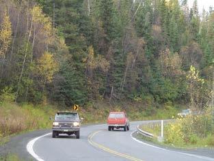
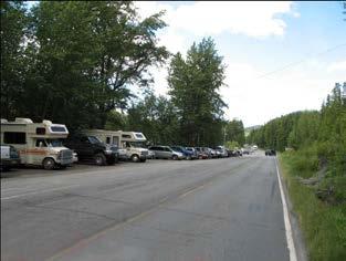
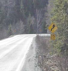
4 Challenges Narrow, curvy highway Many driveways and side roads Local traffic combined with high-speed through traffic Steep valley between Kenai River and mountains Scenery, world-class fishing Numerous cultural and recreational resources Decision not final until FHWA issues a Record of Decision


5 Which alternative is best? Evaluate the benefits Evaluate the impacts Find the solution with the least overall harm
6 Alternatives Four alternatives are evaluated in detail
7 Alternatives Copper Creek Cooper Creek
8 Alternatives G South G South
9 Alternatives Juneau Creek Juneau Creek
10 Alternatives Juneau Creek V Juneau Creek Variant
11 Alternatives No Build The EIS also examines doing nothing

12 Preferred Alternative In 2015, G South was identified as the preferred alternative In the FEIS, March 2018, Juneau Creek is identified as the preferred alternative.
13 Juneau Creek Alternative New Bridge over Juneau Creek
14 Juneau Creek Alternative Tunnels for Forest Service Roads
15 Juneau Creek Alternative Slaughter Gulch Trail Underpass
16 Juneau Creek Alternative
17 Juneau Creek Alternative 3 Wildlife Underpasses 1 Wildlife Overpass Wildlife passage at long bridge
18 Juneau Creek Alternative
19 Juneau Creek Alternative -Two Public Access Pullouts -National Forest Trailhead
20 Juneau Creek Alternative Separation from Kenai River 10 mi. Moves traffic farthest from the Kenai River. Moves traffic away over nearly 10 miles.
21 Juneau Creek Alternative Wilderness Juneau Creek Alternative no longer expected to use Federal Wilderness An unrelated land swap pre-approved by Congress had not occurred. Land swap now reasonably foreseeable. Alternative would use CIRI land instead of Wilderness.
22 Juneau Creek Alternative Land selection Unit 395 State Land Concern: Would highway route selection steer DNR s decision to select land for development? Decision made: DNR decided in 2015 to pass Unit to Borough regardless of this project.

23 Juneau Creek Alternative Compensatory Mitigation for Resurrection Pass Trail impacts Note: Vanessa working on better graphic Add pedestrian passage for Iditarod National Historic Trail to Snow River bridges (Seward Highway).
24 Least Overall Harm There is no obvious good solution. All alternatives create important impacts. DOT&PF and FHWA weighed and balanced the issues.


25 G South Alternative Why no longer Preferred? All traffic remains close to Kenai River. New bridge over river. Impacts to bear feeding area difficult to mitigate. Identified as preferred in Subsequent comments altered weighting of concern about Kenai River.
26 Why not the Cooper Creek Alternative? Routes Highway Traffic Through Downtown Proximity to River Noise and Relocations Traffic/Congestion Worst Performance

27 Why not the Cooper Creek Alternative? Community Impacts: Noise, Traffic, and Congestion Proximity to River Noise and Relocations Traffic/Congestion Worst Performance


28 Why not the Cooper Creek Alternative? Requires considerable private property Proximity to River Noise and Relocations Traffic/Congestion Worst Performance

29 Why not the Cooper Creek Alternative? Performs Most Poorly Proximity to River Noise and Relocations Traffic/Congestion Worst Performance
30 Why not the Cooper Creek Alternative? Continues to route all traffic close to Kenai River Proximity to River Noise and Relocations Traffic/Congestion Worst Performance

31 Why not the Juneau Creek Variant? Bisects cultural land selected by CIRI Heart of Sqilantnu-Russian River Confluence Site. Land is not replaceable. Agencies and Tribes indicate it can t be mitigated.


32 Why not the Juneau Creek Variant? Concerns about cultural & historic values Heart of Sqilantnu-Russian River Confluence Site. Land is not replaceable. Agencies and Tribes indicate it can t be mitigated.
33 Juneau Creek Preferred Moves highway traffic away from Kenai River. Separates local community and recreation traffic from through traffic. Largely avoids impacts to: Kenai National Wildlife Refuge designated wilderness CIRI selected cultural land Private property (including noise impacts) Performs best for traffic.

34 Next Steps Gather feedback on FEIS Record of Decision anticipated April/May Design could start in 2018 Construction

35 Construction Phase 1. Rebuild existing segments, and access bridge site. Phase 2. Build bridge. Phases 3. & 4. Build final grade for new alignment east and west. Phase 5. Pave new alignment, and connect to Phase 1. $77M $89M $48M $56M $30M Total: $299.4 Million Construction could begin in 2020

36 Ways to Comment Fill out a comment sheet Visit the website Please share your thoughts by April 16, 2018
37 Thank you. Questions?
3.8 Park and Recreation Resources Affected Environment
 3 Affected Environment and Environmental Consequences 3.8 Park and Recreation Resources Sterling Highway MP 45 60 Project Final EIS A Recreation Analysis (HDR and USKH 2013) completed for this project
Appendix F Section 4(f) De Minimis Findings Forms DRAFT
 De Minimis Findings Forms DRAFT") Appendix F Section 4(f) De Minimis Findings Forms Prepared for: State of Alaska Department of Transportation and Public Facilities Prepared by: HDR, Inc. 2525 C Street, Suite 305 Anchorage, Alaska 99503
Appendix F Section 4(f) De Minimis Findings Forms Prepared for: State of Alaska Department of Transportation and Public Facilities Prepared by: HDR, Inc. 2525 C Street, Suite 305 Anchorage, Alaska 99503
3.8 Park and Recreation Resources Affected Environment
 3 Affected Environment and Environmental Consequences 3.8 Park and Recreation Resources Sterling Highway MP 45 60 Project Draft SEIS A Recreation Analysis (HDR and USKH 2013) completed for this project
Record of Decision Sterling Highway Milepost Project
 Record of Decision Sterling Highway Milepost 45 60 Project State Project No: 53014 Federal Project Number: STP-F-021-2(15) : Responses to Comments on the Final EIS May 2018 This page intentionally left
RUSHMORE CONNECTOR TRAIL PROPOSAL
 PURPOSE AND NEED Background The U.S. Forest Service, Black Hills National Forest (Forest Service) has received a special use permit application from the State of South Dakota Department of Game, Fish and
4.0 Context for the Crossing Project
 4.0 Context for the Crossing Project This section provides background information about key features of the North Douglas Crossing project area, and opportunities and constraints. This information is important
1.2 Corridor History and Current Characteristics
 SECTION 1 Description and Background of Study Area 1.1 Introduction This preliminary engineering report was prepared for the Alaska Department of Transportation and Public Facilities (ADOT&PF). It is part
Lanie Fleischer Chester Creek Trail Improvements Public Meeting #2. February 4, 2014
 Lanie Fleischer Chester Creek Trail Improvements Public Meeting #2 February 4, 2014 Meeting Agenda 1) Project Team Introduction 2) Project Description 3) Present Survey & Workshop responses 4) Phase 1
Stage 2 ION: Light Rail Transit (LRT) from Kitchener to Cambridge
 from Kitchener to Cambridge") Stage 2 ION: Light Rail Transit (LRT) from Kitchener to Cambridge Public Consultation Centre (PCC) No. 3 Please Sign-in Cambridge City Hall November 21, 2017 2:00 to 8:00pm Preston Memorial Auditorium
Stage 2 ION: Light Rail Transit (LRT) from Kitchener to Cambridge Public Consultation Centre (PCC) No. 3 Please Sign-in Cambridge City Hall November 21, 2017 2:00 to 8:00pm Preston Memorial Auditorium
Executive Summary. Executive Summary
 Executive Summary Executive Summary A North Douglas Crossing of Gastineau Channel is one of the City and Borough of Juneau (CBJ) Assembly s top transportation priorities. Project objectives are to improve
Welcome KROSNO CREEK DIVERSION PROJECT CLASS ENVIRONMENTAL ASSESSMENT
 Welcome KROSNO CREEK DIVERSION PROJECT PUBLIC INFORMATION CENTRE # 1 Tonight s Presentation Study Overview Background Existing Conditions Alternative Solutions Preliminary Preferred Solution Next Steps
Final Environmental Impact Statement for the Merced Wild and Scenic River. Comprehensive Management Plan, Yosemite National Park, Madera and Mariposa
 This document is scheduled to be published in the Federal Register on 02/26/2014 and available online at http://federalregister.gov/a/2014-04061, and on FDsys.gov DEPARTMENT OF THE INTERIOR 4312-FF NATIONAL
At the time, the portion of the line through Eagle County remains wholly under the ownership of Union Pacific Railroad (UP).
.") Chapter 5 The Railroad Corridor as a Trail Corridor The intent of this chapter is to identify how the rail corridor, if available for lease or purchase in all or part, could be incorporated into the core
Chapter 5 The Railroad Corridor as a Trail Corridor The intent of this chapter is to identify how the rail corridor, if available for lease or purchase in all or part, could be incorporated into the core
October 2014 BELLINGHAM INTERNATIONAL AIRPORT MASTER PLAN PRESENTATION
 October 2014 BELLINGHAM INTERNATIONAL AIRPORT MASTER PLAN PRESENTATION The Master Plan Process Inventory Of Existing Conditions Complete. Forecasts Of Aviation Demand Complete. Facility Requirements Complete.
HAMPTON ROADS CROSSINGS PATRIOTS CROSSING AND HRBT
 HRTPO Board Meeting March 21, 2013 Agenda ITEM #9: HAMPTON ROADS CROSSINGS PATRIOTS CROSSING AND HRBT Congestion at the Hampton Roads Bridge-Tunnel (HRBT) on I-64 has long been identified as a problem
NORTHEAST CARLTON COUNTY BICYCLE ROUTE PLAN
 NORTHEAST CARLTON COUNTY BICYCLE ROUTE PLAN 5/31/2014 and St. Louis River Trail Plan Update Produced by the Arrowhead Regional Development Commission (ARDC) in Partnership with the State Health Improvement
Finn Creek Park. Management Direction Statement Amendment
 Finn Creek Park Management Direction Statement Amendment November 2013 Management Direction Statement Amendment Approved by: Jeff Leahy Regional Director, Thompson Cariboo BC Parks November 12, 2013 Date
MEETING MINUTES District 1 Trail Planning Meeting 1
 MEETING MINUTES District 1 Trail Planning Meeting 1 June 1, 2017 2:00 PM 3:30 PM City of Two Harbors 2:00 Introductions Attendees: Lisa Austin, MnDOT Bryan Anderson, MnDOT Jasna Hadzic-Stanek, MnDOT Justin
The Chu property is a 6.57 acre parcel located in the Town of Superior on the west side of McCaslin Boulevard. In 2014, the Town of Superior acquired
 1 The Chu property is a 6.57 acre parcel located in the Town of Superior on the west side of McCaslin Boulevard. In 2014, the Town of Superior acquired the Chu property for open space with a contribution
Meeting Notes Public Open House
 Meeting Notes Public Open House, 5:30-8:00 pm Fairbanks Pipeline Training Center, 3605 Cartwright Court, Fairbanks, Alaska= Agenda: Open House: 30 minutes Presentation: 45 minutes Question and Answers:
Public Open House. Chief Peguis Trail Project
 Public Open House Chief Peguis Trail Project CHIEF PEGUIS TRAIL OPEN HOUSE Welcome! Please browse the display boards Project Engineers and City of Winnipeg representatives are available to address your
4.19 Parks, Recreation, and Conservation Lands
 interchange would have on the Reed Paige Clark Homestead located on the north side of Stonehenge Road. Alternative D would also affect Palmer Homestead, E.F. Adams House, and Knapp Brothers Shoe Manufacturing
DULLES AREA HIGHLIGHTS. Gary Garczynski Commonwealth Transportation Board Northern Virginia District. Committee for Dulles August 4, 2016
 DULLES AREA HIGHLIGHTS Gary Garczynski Commonwealth Transportation Board Northern Virginia District Committee for Dulles August 4, 2016 Smart Scale (formerly HB2) Overview Round 1 completed with the adoption
SECTION 106 ACTIVITIES ANNUAL REPORT
 SECTION 106 ACTIVITIES ANNUAL REPORT FOR THE YEAR ENDING DECEMBER 31, 2011 Metropolitan Washington Airports Authority 1593 Spring Hill Road, Suite 300 Vienna, Virginia 22182 JANUARY 2012 Introduction The
A number of goals were identified during the initial work on this Big Lake Transportation Plan.
 C. Transportation General Background Information Big Lake s transportation system includes all the roads, paths and facilities that allow the movement of private vehicles, trains and planes, as well as
White Oak Creek. Recreational Use Attainability Analysis Summary of Findings. Texas Institute for Applied Environmental Research Stephenville, Texas
 White Oak Creek Recreational Use Attainability Analysis Summary of Findings Texas Institute for Applied Environmental Research Stephenville, Texas August 8, 2016 Sulphur Springs, Texas August 9, 2016 Mount
Segment 2: La Crescent to Miller s Corner
 goal of the USFWS refuges is to conserve, protect and enhance fish, wildlife and plants and their habitats for the continuing benefit of the American people. Refuge lands are used largely for fishing,
Trail # NW Tuesday, June DESIGN. Provide an Review the Provide an. Project Goals: System system. wayfinding
 I. Welcome / Introductions Bethany Creek Trail #2 Segment 3 Neighborhood Meeting #1 Bethany Presbyterian Church 15505 NW Springville Road, Portland, OR 97229 Tuesday, June 26, 2018 @ 6:00PM Meeting Minutes
FEDERAL HIGHWAY ADMINISTRATION NEVADA DEPARTMENT OF TRANSPORTATION ENVIRONMENTAL IMPACT STATEMENT RE-EVALUATION
 FEDERAL HIGHWAY ADMINISTRATION NEVADA DEPARTMENT OF TRANSPORTATION ENVIRONMENTAL IMPACT STATEMENT RE-EVALUATION Project Name: Boulder City/US 93 Corridor Study (Boulder City Bypass) Project Location: The
Mickelson Connector Feasibility Study
 Friends of the Norbeck PO Box 2003 Rapid City, SD 57709 www.friendsofthenorbeck.org Summary Comments on the Mickelson Connector Feasibility Study Prepared by Brian Brademeyer Submitted to Wyss Associates
Longmont to Boulder Regional Trail Jay Road Connection DRAFT FINAL REPORT
 Longmont to Boulder Regional Trail Jay Road Connection DRAFT FINAL REPORT December 2018 Project Summary Boulder County, Colorado, in partnership with the City of Boulder, is evaluating options for multi-use
DECISION MEMO. Rawhide Trail #7073 Maintenance and Reconstruction
 Page 1 of 6 Background DECISION MEMO USDA Forest Service Jefferson Ranger District Jefferson County, Montana Rawhide Trail #7073 is located in the Elkhorn Mountain Range approximately 10 miles east of
Final General Management Plan/Wilderness Study/Environmental Impact Statement:
 This document is scheduled to be published in the Federal Register on 03/11/2016 and available online at http://federalregister.gov/a/2016-05542, and on FDsys.gov DEPARTMENT OF THE INTERIOR 4312-FF National
Macleod Trail Corridor Study. Welcome. Macleod Trail Corridor Study Open House. Presentation of Proposed Design Concepts
 Macleod Trail Corridor Study Welcome Macleod Trail Corridor Study Open House Presentation of Proposed Design Concepts Study Purpose Develop a corridor plan for Macleod Trail that aligns with The City s:
Greater Minnesota Regional Parks and Trails Commission Designation Application
 Greater Minnesota Regional Parks and Trails Commission Designation Application General Section Designation Application #: 15-050D Date Submitted: 06/30/2015 Park or Trail Name: Perham to Pelican Rapids
Port MacKenzie Rail Extension
 Port MacKenzie Rail Extension Project The Matanuska-Susitna Borough (MSB) and the Alaska Railroad Corporation (ARRC) jointly propose construction and operation of a new rail line to connect the Borough
Legal Notice. Columbus and Franklin County Metro Parks Request for Statement of Qualifications (RFQ): Professional Design and Engineering Services
: Professional Design and Engineering Services") Legal Notice Columbus and Franklin County Metro Parks Request for Statement of Qualifications (RFQ): Professional Design and Engineering Services Olentangy River Trail Connector Public Notice: The Columbus
Legal Notice Columbus and Franklin County Metro Parks Request for Statement of Qualifications (RFQ): Professional Design and Engineering Services Olentangy River Trail Connector Public Notice: The Columbus
Public Notice ISSUED: December 10, 2018 EXPIRES: January 9, 2019
 APPLICANT: REFER TO: St. Louis and Lake Counties Regional Rail Authority 2018-01942-ARC Public Notice ISSUED: December 10, 2018 EXPIRES: January 9, 2019 SECTION:404 - Clean Water Act 1. APPLICATION FOR
EAST DON TRAIL ENVIRONMENTAL ASSESSMENT. Community Liaison Committee Meeting #3 July 15, :30 to 8:30 pm Flemingdon Park Library
 EAST DON TRAIL ENVIRONMENTAL ASSESSMENT Community Liaison Committee Meeting #3 July 15, 2013 6:30 to 8:30 pm Flemingdon Park Library Agenda 1. Welcome 2. Housekeeping and Updates a) Housekeeping b) CLC
Additional Economic Development Strategy submissions- Klickitat County
 Klickitat County Transportation Improvement Projects 1 White Salmon to Hood River Bridge Final EIS, design, bridge replacement 2 Klickitat County Rural Arterials Reconstruct to all-weather roads Part of
Lake Erie Commerce Center Traffic Analysis
 LOCATION: East of NYS Route 5 at Bayview Road Town of Hamburg Erie County, New York PREPARED BY: Wendel Companies 140 John James Audubon Parkway Suite 200 Amherst, New York 14228 January 2012 i ii Table
Claremont Project Background and Update Community Meeting September 11, 2017
 Claremont Project Background and Update Community Meeting September 11, 2017 Topics Project Background Claremont Segment Information Project Timeline Upcoming Discussion Items Upcoming Meetings Questions
CHAPTER 4 -- THE LAND USE PLAN: DESCRIPTIONS AND POLICIES FOR THIRTEEN PLANNING AREAS
 CHAPTER 4 -- THE LAND USE PLAN: DESCRIPTIONS AND POLICIES FOR THIRTEEN PLANNING AREAS NORTH CENTRAL CAC AREA LITTLE VALLEY ROAD TO JUG HANDLE CREEK PLANNING AREA This planning area includes Cleone, Noyo,
C. APPROACH FOR IDENTIFYING THE BEST ROUTES FOR THE NEEDED TRANSMISSION SYSTEM IMPROVEMENTS
 C. APPROACH FOR IDENTIFYING THE BEST ROUTES FOR THE NEEDED TRANSMISSION SYSTEM IMPROVEMENTS CL&P s approach for identifying the best routes for the needed transmission system improvements included a determination
Proposal to Redevelop Lower Kananaskis River-Barrier Lake. Bow Valley Provincial Park. Frequently Asked Questions
 Proposal to Redevelop Lower Kananaskis River-Barrier Lake Bow Valley Provincial Park Frequently Asked Questions What is being proposed? What are the details of the proposal? Where is the project area located?
Blue River Trail Master Plan JSA to Town Hall June 2004
 Blue River Trail Master Plan JSA to Town Hall June 2004 Prepared for: Silverthorne Town Council Silverthorne SPORT Committee Department of Recreation and Culture Silverthorne Public Works Silverthorne
APPENDIX F List of Commitments
 APPENDIX F List of Commitments s Table F.1 Standard Mitigation Measures Mitigation Measure MnDOT Specification Number Status Update Description Status Update Utilities Provide early notice to utility operators
TRUCKEE TAHOE AIRPORT DISTRICT BOARD OF DIRECTOR STAFF REPORT
 AGENDA ITEM: 11 TRUCKEE TAHOE AIRPORT DISTRICT BOARD OF DIRECTOR STAFF REPORT AGENDA TITLE: MEETING DATE: January 24, 2018 PREPARED BY: NTPUD Agency Partnership Opportunity, Multi-Use Trailhead Access
HIGHWAY 17 WILDLIFE and REGIONAL TRAIL CROSSINGS
 HIGHWAY 17 WILDLIFE and REGIONAL TRAIL CROSSINGS Agenda and Meeting Format 7:00-7:15 Welcome 7:15-8:00 Presentation 8:00-8:30 Open House 8:30 Recap 9:00 Conclusion 2 Meeting Goals: Introduce the project
Port MacKenzie Rail Extension
 Port MacKenzie Rail Extension Project The Matanuska-Susitna Borough (MSB) and the Alaska Railroad Corporation (ARRC) jointly propose construction and operation of a new rail line to connect the Borough
A Publication of Friends of Sleeping Bear Dunes
 A Publication of Friends of Sleeping Bear Dunes 2014, Friends of Sleeping Bear Dunes, P.O. Box 545, Empire, MI 49630 www.friendsofsleepingbear.org info@friendsofsleepingbear.org Learn more about the Friends
Draft General Management Plan/Wilderness Study/Environmental Impact Statement
 This document is scheduled to be published in the Federal Register on 05/06/2015 and available online at http://federalregister.gov/a/2015-10528, and on FDsys.gov DEPARTMENT OF THE INTERIOR National Park
Community Development
 Community Development City & Borough of Juneau Community Development 155 S. Seward Street Juneau, AK 99801 (907) 586 0715 Phone (907) 586 4529 Fax DATE: February 11, 2016 TO: FROM: Planning Commission
MAIN POINTS OF PRESENTATION BY RUTH BONSIGNORE, JON FEINSTEIN AND TONY GRANDE, VHB
 Maine Department of Transportation Aroostook County Transportation Study Public Advisory Committee (PAC) Meeting Minutes PAC Meeting No. 22 Tuesday, March 16 th, 2004 Caribou Inn and Convention Center
EAST LINK EXTENSION 2017 SEPA Addendum
 EAST LINK EXTENSION 2017 SEPA Addendum SEATTLE MERCER ISLAND BELLEVUE OVERLAKE REDMOND MERCER ISLAND BELLEVUE OVERLAKE REDMOND Washington State Department of Transportation East Link Extension 2017 SEPA
WELCOME to the Iditarod Dog Sledding Historic District (IDSHD) Workshop. January 11, Houston Middle School Houston, Alaska
 Workshop. January 11, Houston Middle School Houston, Alaska") WELCOME to the Iditarod Dog Sledding Historic District (IDSHD) Workshop January 11, 2012 Houston Middle School Houston, Alaska Workshop Purpose: Present/discuss proposed resolutions to comments received
WELCOME to the Iditarod Dog Sledding Historic District (IDSHD) Workshop January 11, 2012 Houston Middle School Houston, Alaska Workshop Purpose: Present/discuss proposed resolutions to comments received
October 18, Terry Hartwick Director, North Little Rock Parks and Recreation 2700 Willow Street North Little Rock, AR 72114
 October 18, 017 Terry Hartwick Director, North Little Rock Parks and Recreation 700 Willow Street North Little Rock, AR 7114 Dear Mr. Hartwick: Re: ARDOT Job Number CA060 30 Crossing Pulaski County The
12, 14 and 16 York Street - Amendments to Section 16 Agreement and Road Closure Authorization
 REPORT FOR ACTION 12, 14 and 16 York Street - Amendments to Section 16 Agreement and Road Closure Authorization Date: April 27, 2018 To: Toronto and East York Community Council From: Senior Strategic Director,
Citrus Heights Creek Corridor Trail Project Trail Advisory Group Field Trip #2 September 11, :00 11:00 am Trellis Hall, Citrus Heights
 September 11, 2013 9:00 11:00 am Trellis Hall, Citrus Heights Project Overview The City of Citrus Heights is studying the feasibility of establishing a multi use trail system within the City s 26 miles
Mountain Peaks & Glaciers, Alaska National Parks
 Mountain Peaks & Glaciers, Alaska National Parks 15 Days / 14 Nights Anchorage to Anchorage From USD$4,446 per person Highlights: Alaska National Parks Anchorage Seward Homer Talkeetna Denali Fairbanks
Northwest Corridor LRT Line to Irving/DFW
 Northwest Corridor LRT Line to Irving/DFW AGENCY SCOPING May 25, 2005 NW to Irving/DFW Agenda: Introductions Project Development Process Project Update Federal Involvement Scoping Project Schedule Decisions
PUBLIC SCOPING MEETING APRIL 2018
 Photo credit: Patrick Schneider PUBLIC SCOPING MEETING APRIL 2018 Welcome to the meeting! The Federal Aviation Administration (FAA) is preparing an Environmental Impact Statement (EIS) to evaluate the
Environmental Assessment and Final Section 4(f)
") Environmental Assessment and Final Section 4(f) South Pleasant View Road, City of Madison County Highway M Reconstruction Cross Country Road to Prairie Hill Road Project ID 5992-09-81 September 16, 2016
Environmental Assessment and Final Section 4(f) South Pleasant View Road, City of Madison County Highway M Reconstruction Cross Country Road to Prairie Hill Road Project ID 5992-09-81 September 16, 2016
Hudson Highlands Fjord Trail Draft Master Plan. April 29, 2015
 Hudson Highlands Fjord Trail Draft Master Plan April 29, 2015 Agenda Route Overview Proposed Segment Results of Community Survey on that Segment Next Steps Municipal Endorsement Environmental Review Implementation
CLACKAMAS COUNTY BOARD OF COUNTY COMMISSIONERS. Policy Session Worksheet
 CLACKAMAS COUNTY BOARD OF COUNTY COMMISSIONERS Policy Session Worksheet Presentation Date: 10/10/17 Approx. Start Time: 1:30 PM Approx. Length: 60 minutes Presentation Title: An Update on the Sunrise Highway
Section 4(f) and Section 6(f) Technical Analysis
 and Section 6(f) Technical Analysis") WESTSIDE SUBWAY EXTENSION PROJECT Contract No. PS-4350-2000 Section 4(f) and Section 6(f) Technical Analysis Prepared for: Prepared by: WSP USA 851 SW Sixth Avenue, Suite 1600 Portland, Oregon 97204 FEBRUARY
WESTSIDE SUBWAY EXTENSION PROJECT Contract No. PS-4350-2000 Section 4(f) and Section 6(f) Technical Analysis Prepared for: Prepared by: WSP USA 851 SW Sixth Avenue, Suite 1600 Portland, Oregon 97204 FEBRUARY
General Highway System SHEET 1 HILTON HEAD ISLAND URBAN AREA
 5 6 7 8 A A B B General Highway System SHEET 1 HILTON HEAD ISLAND URBAN AREA SECONDARY ROUTE - - - - - 9 WETLAND OR MARSH - - - - - - - - - CHURCH AND CEMETERY - - - - - - - - CEMETERY - - - - - LM 78
HPP & Puna Makai Alternate Route Presentation 2017
 HPP & Puna Makai Alternate Route Presentation 2017 Hawaiian Paradise Park General Membership Meeting June 25, 2017 A Road That Would Divide Us WHAT IS PMAR? PMAR = Puna Makai Alternate Route is a proposed
CREATING CONNECTIONS IN THE CITY OF NIAGARA FALLS PUBLIC MEETING DECEMBER 6, 2017
 CREATING CONNECTIONS IN THE CITY OF NIAGARA FALLS PUBLIC MEETING DECEMBER 6, 2017 CONGESTION COSTS OUR ECONOMY The average commute in Ontario is already over 45 minutes, and that figure jumps to more than
Becker County Trail Routing Feasibility Study
 2016 Becker County Trail Routing Feasibility Study CONNECTING DETROIT MOUNTAIN AND MOUNTAIN VIEW RECREATIONAL AREA TO THE HEARTLAND TRAIL BECKER COUNTY ULTEIG ENGINEERS Contents Acknowledgements...2 INTRODUCTION...3
A. From I-68 in Monongalia County, West Virginia to SR 6119 in Fayette County, Pennsylvania 1
 Mon-Fayette Transportation Project A. From I-68 in Monongalia County, West Virginia to SR 6119 in Fayette County, Pennsylvania 1 The Mon/Fayette Transportation Project (MFTP) from I-68 in West Virginia
Cooper Landing, Alaska
 Cooper Landing, Alaska Walkable Community Project Alternative transportation planning to address congestion and road impacts near the Russian and Kenai Rivers Native Village of Eyak Alternative Transportation
High Speed Two: From Crewe to Manchester, West Midlands to Leeds and beyond
 High Speed Two: From Crewe to Manchester, West Midlands to Leeds and beyond Phase 2b Route Decision Moving Britain Ahead July 2017 September 2016 High Speed Two: From Crewe to Manchester, West Midlands
PROPOSED FOR IMPLEMENTATION
 PROPOSED FOR IMPLEMENTATION Capital Transit Schedule & Route Revision Objective: Update the current Capital Transit schedules and routes to provide a higher level of reliability, add service to Riverside
USGS Efforts to Consolidate Geospatial Data in the Federal Government
 ++ 1 USGS Efforts to Consolidate Geospatial Data in the Federal Government An overview of USGS trails collaborations and updates. Date 5/31/2017 Greg Matthews + Introduction USGS The following slides provide
INFORMATION FOR LONGFORD, HARMONDSWORTH, SIPSON, HARLINGTON AND CRANFORD CROSS COMMUNITIES
 Harmondsworth Proposed north west runway Sipson Harlington Cranford Cross Longford All maps contain OS data Crown copyright and database right 2018 INFORMATION FOR LONGFORD, HARMONDSWORTH, SIPSON, HARLINGTON
Southern Shenandoah Valley Chapter
 Southern Shenandoah Valley Chapter June 7, 2018 Members of the State Water Control Board c/o Office of Regulatory Affairs, Department of Environmental Quality P.O. Box 1105 Richmond, Virginia 23218 citizenboards@deq.virginia.gov
Daisy Dean Trail 628/619 ATV Trail Construction
 Background and Purpose and Need The Daisy Dean ATV Trail Construction Project is located in the Little Belt Mountains, Musselshell Ranger District, Lewis and Clark National Forest approximately 32 miles
Abbey Chesterton bridge Questions & Answers
 Abbey Chesterton bridge Questions & Answers Please click on links below to go to individual subjects: Bridge location and access routes Timescales Bridge details and accessibility Construction compound
Keep Alaska Moving through service and infrastructure
 The West Glacier area of the Mendenhall Glacier Recreation Area is at the end the Skater s Cabin Road, accessed by streets maintained by the City and Borough of Juneau. The West Glacier area serves as
RESPONSE TO AIRPORT EXPANSION CONSULTATION 27 MARCH 2018 Submitted online by Helen Monger, Director
 RESPONSE TO AIRPORT EXPANSION CONSULTATION 27 MARCH 2018 Submitted online by Helen Monger, Director 1. Expanding Heathrow The expansion of Heathrow will be one of the largest infrastructure projects in
Statement of Community Consultation. Trans Pennine Upgrade: Statement of Community Consultation (SoCC)
") Trans Pennine Upgrade: Statement of Community Consultation (SoCC) February 2018 Section 47(1) of the Planning Act 2008 states that the promoter of a proposed Development Consent Order (DCO) application
Trans Pennine Upgrade: Statement of Community Consultation (SoCC) February 2018 Section 47(1) of the Planning Act 2008 states that the promoter of a proposed Development Consent Order (DCO) application
DENISON STREET EXTENSION. Transportation Committee. January 14, Feasibility Study
 DENISON STREET EXTENSION Feasibility Study January 14, 2014 Transportation Committee Markham Transportation Strategic Plan (MTSP) analysis completed in 2012 reviewed transportation requirements to accommodate
INFORMATION FOR STANWELL MOOR AND STANWELL COMMUNITIES
 Proposed north west runway Stanwell Moor Stanwell All maps contain OS data Crown copyright and database right 2018 INFORMATION FOR STANWELL MOOR AND STANWELL COMMUNITIES JANUARY 2018 Airport Expansion
US 83 Relief Route. City of La Joya City of Peñitas Hidalgo County. November 15, 2012
 US 83 Relief Route City of La Joya City of Peñitas Hidalgo County November 15, 2012 TxDOT Mission: Work with others to provide safe and reliable transportation solutions for Texas. Public Meeting Agenda
Laxon Terrace - Sarawia. Click to add title. Street Rail Level Crossing. Public Forum. December
 Laxon Terrace - Sarawia Click to add title Street Rail Level Crossing Public Forum December 2012 www.aucklandtransport.govt.nz Overview of Presentation Objectives and Reasons for Separation Project Background
Mountain Valley Pipeline, LLC Mountain Valley Pipeline Project Docket No. CP
 16. Prior to construction, Mountain Valley shall file with the Secretary, for review and approval by the Director of OEP, a segment-specific construction and operation access plan for the area between
user s guide to Transportation Improvements in Astoria Planning Efforts outside Astoria for more information, contact:
 The Miles Crossing/ Jeffers Garden transportation plan (underway), will identify needed improvements to the Warrenton Astoria Highway and local street improvements to serve expected growth in the Miles
APPENDIX E LYONS PARK ESTATES DETAILED COMMUNITY ASSESSMENT RESULTS
 # Houses: 65 APPENDIX E LYONS PARK ESTATES DETAILED COMMUNITY ASSESSMENT RESULTS Overall Risk Assessment: High Description: Lyons Park Estates is located on the foothills south of the town of Lyons on
Juneau Household Waterfront Opinion Survey
 Juneau Household Waterfront Opinion Survey Prepared for: City and Borough of Juneau Prepared by: April 13, 2004 TABLE OF CONTENTS Executive Summary...1 Introduction and Methodology...6 Survey Results...7
Citrus Heights Creek Corridor Trail Project. Trail Advisory Group Meeting #3 July 8, 2013
 Citrus Heights Creek Corridor Trail Project Trail Advisory Group Meeting #3 July 8, 2013 Agenda Introductions Recap: Community Workshop, Survey Findings, and TAG Field Trip Community Concern Discussion:
POLICY COORDINATING COMMITTEE
 Members Present: Councilman Dennis Pitman for Chairman Tom Hanel, Mayor, City of Billings; Commissioner Jim Reno, Board of County Commissioners; Dick Clark, Planning Board Ward V for Paul Gatzemeier, President,
WATERFRONT PROGRAM PROGRESS REPORT
 WATERFRONT PROGRAM PROGRESS REPORT 2016 (April - June) Highlights from 2016 In April, released the Supplemental Draft Environmental Impact Statement (EIS) for the Alaskan Way, Promenade, and Overlook Walk.
Northern Rail Extension, Phase One
 General Project and Funding 1. Where does Phase One start? The rail line for Phase One begins roughly at the northern boundary of the former Bradbury property, but also includes work along Tom Bear Trail
SECTION 106 ACTIVITIES ANNUAL REPORT
 SECTION 106 ACTIVITIES ANNUAL REPORT FOR THE YEAR ENDING DECEMBER 31, 2014 Metropolitan Washington Airports Authority 198 Van Buren Street, Suite 300 Herndon, Virginia 20170 JANUARY 2015 Introduction The
City of Durango 5.8 FUNDING TRAILS DEVELOPMENT
 5.8 FUNDING TRAILS DEVELOPMENT The City has been successful in establishing dedicated local funding sources as well as applying for grants to develop the City s trail system, having received nearly $2.4
Commercially Guided Helicopter Skiing on the Kenai Peninsula. Record of Decision. United States Department of Agriculture.
 United States Department of Agriculture Forest Service Chugach National Forest R10-MB-538 Commercially Guided Helicopter Skiing on the Kenai Peninsula September 2004 Record of Decision COMMERCIALLY GUIDED
September 14, Comments of the Colorado Trail Foundation On the USFS Scoping Notice of August 13, 2010 RE: the relocation of the CDNST/CT Page 1
 THE COLORADO TRAIL FOUNDATION Comments on the U.S. Forest Service Scoping Notice of August 13, 2010 Regarding the Relocation of THE COLORADO TRAIL AND CONTINENTAL DIVIDE NATIONAL SCENIC TRAIL From La Garita
Abbott Rd Rehabilitation Phase II - Elmore Rd to Birch Rd
 Abbott Rd Rehabilitation Phase II - Elmore Rd to Birch Rd Project ID SOA07003 Department State of Alaska Project Type Improvement Start Date December 2017 Location Assembly: Section 4, Seats F & G, Assembly:
Planning Wildlife Crossings in Canada's Mountain Parks SESSION: Highway Mitigation: new insights for practitioners
 Planning Wildlife Crossings in Canada's Mountain Parks ID95 SESSION: Highway Mitigation: new insights for practitioners Trevor Kinley, Project Manager Lake Louise Yoho Kootenay Field Unit, Parks Canada