Quiet Zone Evaluation for Huron, Ohio
|
|
|
- Posy Randall
- 6 years ago
- Views:
Transcription


")
1 Quiet Zone Evaluation for Huron, Ohio 9601 Camp Bowie West Fort Worth, TX (T)
2 Quiet Zone Evaluation City of Huron, OH Final Report August 2015 Introduction The City of Huron (Agency), in its effort to explore the possibility of prohibiting the sounding of train horns along the Norfolk Southern Railroad (Railroad) through their community, requested CTC, Inc. (CTC) to conduct an evaluation to determine the feasibility and approximate cost associated with creating a new quiet zone through Huron, Ohio. In 2005, the Federal Railroad Administration (FRA) issued 49 CFR Parts 222 and 229, the Final Rule on Use of Locomotive Horns at Highway-Rail Grade Crossings (Final Rule). The purpose of the rule is to mandate a federal requirement for the sounding of locomotive horns at all public highway-rail grade crossings. The rule also establishes both minimum and maximum decibel levels for the locomotive horns themselves. While the purpose of the rule was to require the sounding of locomotive horns, it also created a methodology by which communities could create quiet zones. In accordance with the Final Rule, locomotive horn sounding is not required if each public highway-rail grade crossing is equipped with Supplemental Safety Measures (SSMs) within the proposed quiet zone. SSMs are safety measures that have been determined by the FRA to adequately compensate for the lack of a locomotive horn. Examples of SSMs include: Temporary Closure (can only be used in a Partial Quiet Zone) Four-quadrant gate systems installed with or without vehicle detection Gates with non-transversable median barriers at least 100 feet in length on each side (60 feet if parallel roads or commercial driveways are present) Gates with channelization devices at least 100 feet in length on each side (60 feet if parallel roads or commercial driveways are present) One-way streets with gates that completely close off the roadway Permanent Closure Another possibility for use as a treatment in lieu of a SSM is the Wayside Horn System (WHS). The WHS may be used either within or outside of a quiet zone as a one-for-one replacement for the train horn. The WHS is a traffic control device that is mounted at the highway-rail grade crossing and interconnected to the railroad s grade crossing warning system. It is required to sound at a minimum level of 92 db measured 100 feet along the roadway approach from the nearest track (49 CFR 222, Appendix E, 4). Many communities have implemented this technology as a means of reducing train horn noise levels. In addition, locomotive horn sounding is not required within highway-rail grade crossing corridors that have a Quiet Zone Risk Index (QZRI) at or below the Nationwide Significant Risk Threshold (NSRT) or the Risk Index with Horns (RIWH). Definitions of each of these terms are listed below: Page 1
3 Quiet Zone Evaluation City of Huron, OH Final Report August 2015 Quiet Zone Risk Index (QZRI) is the average risk in the proposed quiet zone taking into consideration the increased risk caused by the lack of train horns and the reductions in risk attributable to the installation of SSMs or Alternative Safety Measures (ASMs). Nationwide Significant Risk Threshold (NSRT) represents a number reflecting a measure of risk, calculated on a nationwide basis, which reflects the average level of risk to the motoring public at public highway-rail grade crossings equipped with flashing lights and gates and at which locomotive horns are sounded. Risk Index with Horns (RIWH) represents the average initial amount of risk in the proposed quiet zone with the train horn sounding. Highway-rail grade crossing corridors that have a QZRI NSRT or RIWH have been deemed, by the FRA, to constitute categories of highway-rail grade crossings that do not present a significant risk with respect to loss of life or serious personal injury or that fully compensate for the absence of the warning provided by the locomotive horn. As a result, communities with highway-rail grade crossing corridors that meet either of these standards may silence the locomotive horn within the crossing corridor if all other applicable quiet zone requirements have been met. Please note, the establishment of a quiet zone does not result in total elimination of all train horn noise. The Final Rule allows for the locomotive engineer to sound the locomotive horn to provide a warning to vehicle operators, animals, pedestrians, trespassers or crews on other trains in an emergency situation if, in the locomotive engineer s sole judgment, such action is appropriate in order to prevent imminent injury, death or property damage. In addition, nothing in the rule prohibits the use of the locomotive horn in the following situations: 1. When a wayside horn is malfunctioning. 2. When active grade crossing devices have malfunctioned and use of the horn is required. 3. When grade crossing warning systems are temporarily out of service during inspection, maintenance or testing of the systems. 4. When the SSM, modified SSMs or engineered SSMs no longer comply with the requirements of the rule or as approved by the FRA. 5. There is no restriction for the sounding of the locomotive horn for the purposes of highway-rail crossing safety such as, to announce the approach to roadway workers under chapter 49 or required purposes under railroad operating rules. The City should make every effort to educate the public through public meetings, website, and news articles that some trains will sound horns after the quiet zone is established. CTC s experience has also indicated that it takes approximately days for all railroad engineers to become familiar with a new quiet zone and cease blowing the train horns on a consistent basis. The agency should make the public aware of the grace period needed once the quiet zone is established. Page 2
4 Quiet Zone Evaluation City of Huron, OH Final Report August 2015 Proposed Quiet Zone Corridor The Agency is interested in determining the improvements required and the approximate cost to create a new quiet zone along Norfolk Southern Railroad, Dearborn Subdivision located near the downtown area of Huron, Ohio. The proposed quiet zone corridor is shown in Figure 1. The Railroad runs approximately 96 trains per day at speeds up to 69 mph on this subdivision through the city of Huron, Ohio. The highway-rail grade crossings that were evaluated are described in the table below. Table 1. Proposed Quiet Zone Crossings Street or Road Name DOT No. Railroad Milepost (MP) Subdivision Nearest Parallel Street Berlin Road E Dearborn Cleveland Rd/SH6 River Road L Dearborn Cleveland Rd/SH6 Main Street T Dearborn Jefferson St Williams Street A Dearborn Bogart Rd Rye Beach Road N Dearborn Sawmill Parkway Page 3

5 Quiet Zone Evaluation City of Huron, OH Final Report August 2015 Figure 1. Overall View of Proposed Quiet Zone The limits of the proposed quiet zone will extend from MP to MP for an actual quiet zone length of 3.62 miles. However, due to the location of adjacent crossings within the corridor, the effective length of the proposed quiet zone will be significantly longer. The closest highway-rail grade crossing west of the proposed quiet zone is US 6 at MP The closest highway-rail grade crossing east of the proposed quiet zone is SR 61 at MP As a result, the effective length of the proposed quiet zone will be approximately 5.88 miles. Summary of Quiet Zone Safety Improvement Options CTC conducted a field review of the grade crossings within the proposed Huron quiet zone on the afternoon of July 7, The purpose of the review was to evaluate proposed crossings for basic quiet zone requirements and review quiet zone concepts with Agency representatives in preparation for the agency team meeting and future diagnostic meeting with the Railroad and the FRA. Options available to the Agency for the creation of the quiet zone were presented after the field evaluation. Factors considered in the evaluation were safety, compliance with the FRA rules, public acceptance and budgetary constraints for the implementation of the proposed quiet zone. As recommended in 49 CFR 222, Appendix F the crossings proposed for inclusion in a quiet zone should be reviewed in the field by a diagnostic team composed of railroad personnel, public Page 4
6 Quiet Zone Evaluation City of Huron, OH Final Report August 2015 safety or law enforcement, engineering personnel from the State Agency responsible for grade crossing safety and other concerned parties. A diagnostic meeting will be conducted in the future once the agency has determined the safety improvements planned for each crossing and identified the funding. In the meantime, on July 8, 2015 an agency team, consisting of representatives from the Agency, FRA, and CTC reviewed each of the highway-rail grade crossings in the proposed quiet zone for consideration of the options for the approved SSMs as provided in 49 CFR 222, Appendix A. The agency team members in attendance were: Andy White, City Manager Mike Spafford, Assistant to the City Manager Gene Esser, City Engineer (OHM Advisors) Doug Green, City Engineer (OHM Advisors) Evelyn Hendricks, FRA Grade Crossing Manager Tim Oster, CTC, Inc. The Final Rule, Appendix A to Part 222 A, provides a list of approved supplementary safety measures (SSMs) that may be installed at each crossing within a quiet zone for risk reduction credit. Each SSM has been assigned an effectiveness rate which is defined as a number between zero and one which represents the reduction of the likelihood of a collision at a public highwayrail grade crossing as a result of the installation of an SSM or ASM when compared to the same crossing equipped with conventional active warning systems of flashing lights and gates. Zero effectiveness means that the SSM or ASM provides no reduction in the probability of a collision, while an effectiveness rating of one means that the SSM or ASM is totally effective in eliminating collision risk. The effectiveness rate for SSMs are as follows: Approved Supplemental Safety Measure (SSM) Effectiveness Rate Temporary or Permanent Closure of a crossing 1.00 One-Way Street with Gates 0.82 Gates with Medians (Non-Traversable curbs) 0.80 Four Quadrant Gate System with presence detection 0.77 Gates with Channelization devices 0.75 Page 5
7 Quiet Zone Evaluation City of Huron, OH Final Report August 2015 The results of that evaluation are shown as follows: P Preferred Supplemental Safety Measure O Optional Supplemental Safety Measure U Undesirable (due to public acceptability or budget constraints) Table 2. Supplemental Safety Measures Options Street or Road Name DOT No. Crossing Closure Four-Quadrant Gate System Concrete/ Channelization Median Barrier One- Way Street Wayside Horn System Berlin Road E U U P U O River Road L U U P U O Main Street T U O P U U Williams Street A P O O U U Rye Beach Road N U U P U U Page 6
8 Quiet Zone Evaluation City of Huron, OH Final Report August 2015 This review also determined if the existing railroad active grade crossing warning devices meet the minimum requirements for establishment of a quiet zone. The rule requires that each public highway-rail grade crossing in the quiet zone must be equipped with flashing lights and gates, constant warning time device and power out indicator in accordance with 49 CFR Subpart C (3)(b). The following table provides the results of that review: Table 3. Active Grade Crossing Warning Devices Street or Road Name DOT No. Flashing Lights, Gates and Bells Constant Warning Time Devices Power Out Indicator Berlin Road E River Road L Main Street T Williams Street A Rye Beach Road N The above reference data was obtained from the Federal Railroad Administration (FRA) website inventory forms. If it is determined later that any of this data is inaccurate, the proposed project cost may be adversely affected due to increased railroad equipment upgrades. An overview of each crossing and discussion of the evaluation are described below. Page 7

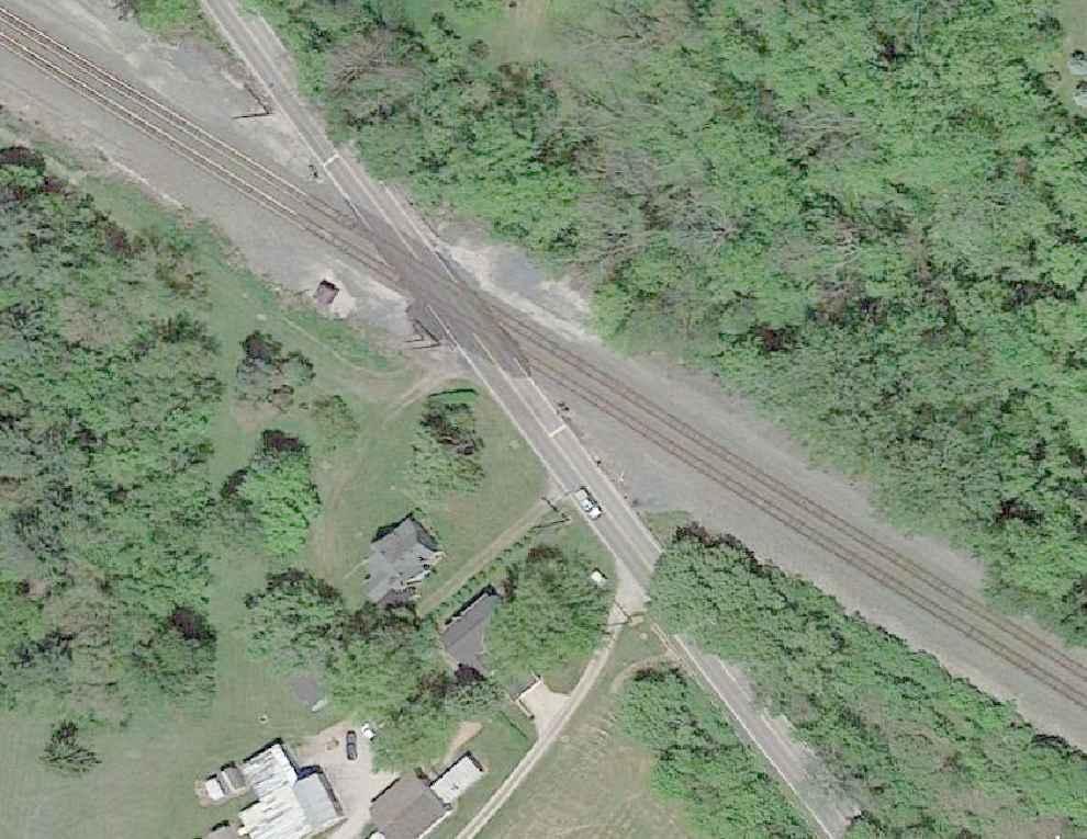
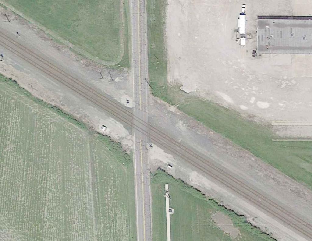
9 Quiet Zone Evaluation City of Huron, OH Final Report August 2015 Berlin Road DOT No E The Berlin Road crossing, located at railroad milepost , is the eastern most crossing of the proposed quiet zone. Berlin Road is a two lane roadway crossing over two main line tracks. The roadway is approximately 24 feet wide and constructed of asphalt composition with no curb and gutter. The crossing is constructed with an asphalt crossing with asphalt pavement between tracks. There is private driveway approximately 30 feet south of the southeast gate and private grass driveway access located just 15 south of the crossing inside the northbound gate. Figure 2. Berlin Road Aerial View The agency review team considered the approved SSM options provided in 49 CFR 222, Appendix A and agreed with the Agency s preference for this location to install non-traversable concrete median barriers The required median length of 100 feet would require one private driveway and the grass driveway access to the private property to be a right-in and right-out only. The agency will discuss this option with the owner to determine if the installation of the median is acceptable. It was also noted that the mailbox for the home is located on the east side of the street. As a result, the proposed median would prevent picking up their mail from the car driver side window as witnessed during our field inspection. The team recommended that concrete median barriers be 160 feet in length to the south and 160 feet to the north, one foot wide and 7 inches high. The additional 60 feet in length above the FRA requirement for both approaches is due to the angle of the crossing which places the existing gate tips approximately 75 feet from the nearest rail. The team recommended the Page 8
10 Quiet Zone Evaluation City of Huron, OH Final Report August 2015 additional median between the gate and the crossing to improve the safety and prevent drivers from accessing the street behind the existing gates. The proposed median to the south includes one private driveway located 30 feet from the railroad gate. Although this is allowed under the FRA train horn rule, the resident will have a right-in and right-out only and there is no safe turnaround existing in the area to provide access north towards downtown area. Therefore, the team proposed the installation of a traffic round-about approximately 250 feet from the crossing to provide a safe and convenient method for the resident to get to downtown area. Should the plans for the installation of the median and round-about be determined not to be a feasible solution, a wayside horn system is the alternative recommendation by the team. The installation of the wayside horn system requires an interconnection with the railroad equipment for proper operation. The following signs and pavement markings will need to be installed to comply with 49 CFR (c) and MUTCD: W10-1 Advance Warning signs with W10-9 No Train Horn plaques will be installed on each approach. New stop lines prior to each gate and railroad pavement markings. Page 9

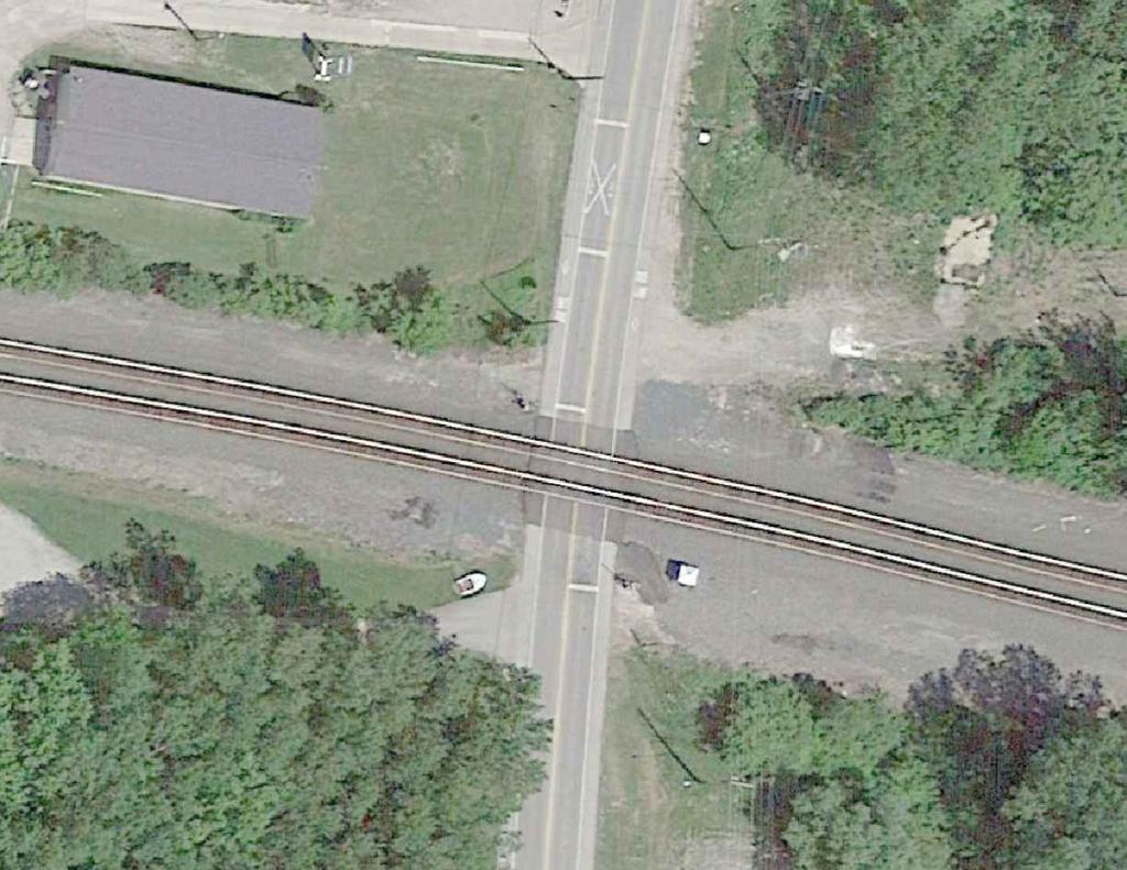
11 Quiet Zone Evaluation City of Huron, OH Final Report August 2015 River Road DOT No L The River Road crossing is located at railroad milepost and is the next crossing to the west of Berlin Road. River Road is a two lane roadway crossing over two main line tracks. The roadway is approximately 24 feet wide with 5 foot bike lanes on both approaches. The roadway is asphalt composition with no curb and gutter on the approaches to the crossing. The crossing is an asphalt crossing surface with asphalt pavement between the tracks. The crossing is located approximately 260 feet south of the stop controlled intersection at Cleveland Raod/SH 6. There is a commercial gravel driveway adjacent to the crossing in the southwest quadrant that provides access to a local business. Figure 3. River Road Aerial View The agency review team considered the approved SSM options provided in 49 CFR 222, Appendix A and agreed with the Agency s preferred option to install non-traversable concrete median barriers. The proposed median lengths are 100 feet to the north and 60 feet to the south. There is a commercial driveway located less than 10 feet from the railroad gate to the south of the crossing. The team proposed that the driveway be relocated to a minimum of 60 feet south of the existing gate which would result in the median qualifying as a SSM. The relocation of the driveway will require the acquisition of adjacent property to accommodate the new driveway and the construction of approximately 100 feet of gravel/asphalt road. This solution depends on the willingness of both private property owners to facilitate the relocation of the driveway. The City will evaluate the feasibility of relocating the commercial driveway to provide the required 60 foot median length. Page 10
12 Quiet Zone Evaluation City of Huron, OH Final Report August 2015 Should the plans for the installation of the median be determined not to be a feasible solution, a wayside horn system is the alternative recommendation by the team. The following signs and pavement markings will need to be installed to comply with 49 CFR (c) and MUTCD: W10-1 and Advance Warning signs with W10-9 No Train Horn plaques will be installed on each approach. New stop lines prior to each gate and railroad pavement markings Page 11

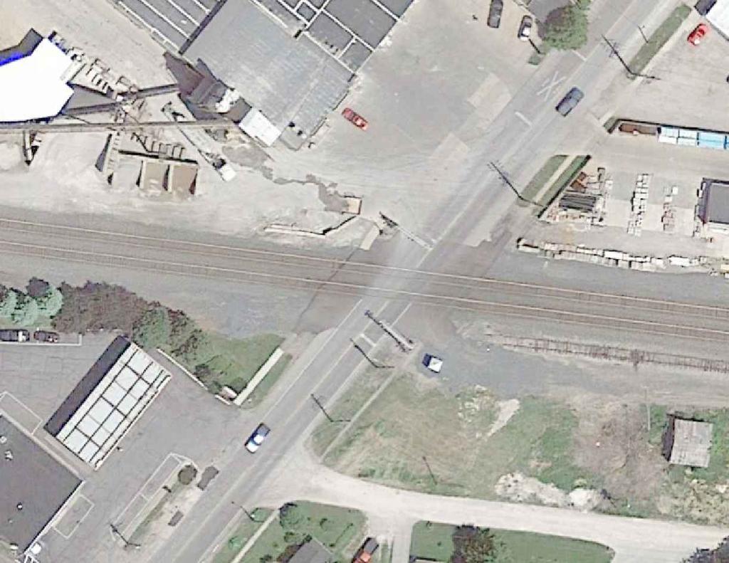
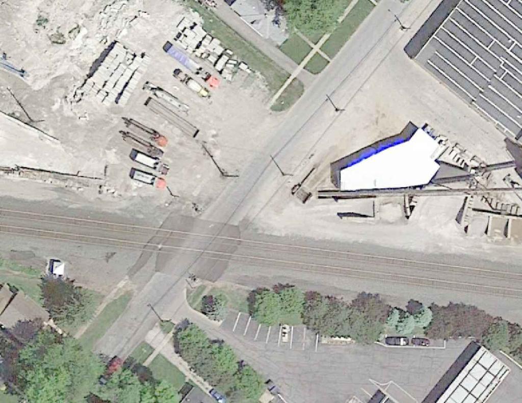
13 Quiet Zone Evaluation City of Huron, OH Final Report August 2015 Main Street DOT No T The Main Street crossing is located at railroad milepost and is the next crossing to the west of the River Road crossing. Main Street is a two lane roadway crossing over two main line tracks between River Road to the east and Williams Street to the west. The roadway is approximately 24 feet wide with a 5 foot shoulder to the west. The street is asphalt composition with no curb and gutter on the approaches to the crossing. There are commercial driveways just to the north of the crossing in the northwest and northeast quadrants. The crossing is an asphalt crossing surface with asphalt pavement between the tracks. Figure 4. Main Street Aerial View The agency review team considered the approved SSM options provided in 49 CFR 222, Appendix A and agreed with the Agency s preferred option to install non-traversable concrete median barriers. The proposed median lengths are 60 feet to the north and 75 feet to the south. There is a commercial driveway located approximately 90 feet to the south that limits the length of the median to the south but does qualify as SSM. However, commercial driveways located on both sides of the Main Street to the north that provide access for the Huron Cement Company prohibits the installation of a SSM compliant median under existing conditions. The agency will discuss the proposal with the business owner to determine if the installation of the median and the installation of sixty feet of curb to reduce the existing driveway length is acceptable to the business owner. If business owner approves the plan, a SSM compliant median 60 feet in length will be installed along with curb and gutter to define the driveway access in the northwest Page 12
14 Quiet Zone Evaluation City of Huron, OH Final Report August 2015 quadrant. Curb and gutter will be installed in the northeast quadrant to eliminate the existing concrete driveway access to the gated storage area. Should the plans for the installation of the median not be a feasible solution, a four quadrant gate system is the alternative recommendation by the team. The following signs and pavement markings will need to be installed to comply with 49 CFR (c) and MUTCD: W10-1 Advance Warning signs and W10-9 No Train Horn plaques will need to be installed on each approach on Main Street. New stop lines prior to each gate and railroad pavement markings. Page 13

15 Quiet Zone Evaluation City of Huron, OH Final Report August 2015 Williams Street DOT No A The Williams Street crossing is located at railroad milepost , just west of the Main Street crossing. Williams Street is a two lane roadway crossing over two main line tracks. The roadway is approximately 26 feet wide and constructed of asphalt composition. The crossing is an asphalt crossing surface with asphalt pavement between the tracks. There are commercial driveways located in the southeast quadrant approximately 20 feet south of the gate and on both sides of the street north of the crossing. Figure 5. Williams Street Aerial View The agency review team considered the approved SSM options provided in 49 CFR 222, Appendix A and agreed with the Agency s preferred option of permanent closure of this crossing. Specific requirements for the permanent closure will require additional analysis by the city and railroad once approval is obtained to permanently close the crossing. However, at a minimum, all pavement should be removed from railroad right of way and Type III barricades (or equivalent) installed on both approaches to prevent vehicle access to the area. Additional fencing, barriers, etc. may be required to prevent pedestrian access to the area. The railroad will remove all railroad signal equipment and crossing panels. The diagnostic team agreed with the Agency that if permission to close crossing is not obtained, then the preferred quiet zone treatment would be the installation of a four quadrant gate system Page 14
16 Quiet Zone Evaluation City of Huron, OH Final Report August 2015 Additionally with The following signs and pavement markings will need to be installed to comply with 49 CFR (c) and MUTCD: W10-1 Advance Warning signs and W10-9 No Train Horn plaques will need to be installed on each approach on Danville Road. New stop lines prior to each gate and railroad pavement markings. Page 15

17 Quiet Zone Evaluation City of Huron, OH Final Report August 2015 Rye Beach Road DOT No N The Rye Beach Road crossing is located at railroad milepost and is the western most crossing in the proposed quiet zone. Rye Beach Road is a two lane roadway crossing over two main line tracks. The roadway is approximately 24 feet wide and is asphalt composite with no curb and gutter. The crossing is constructed with an asphalt crossing with asphalt pavement between tracks. Figure 6. Rye Beach Road Aerial View The agency review team considered the approved SSM options provided in 49 CFR 222, Appendix A and agreed with the Agency s preference for this location for a non-traversable concrete median barrier. The team recommended that concrete median barriers be 100 feet in length to the south and 100 feet to the north which will qualify as a SSM. The minimum median height of 7 inches is recommended and the team proposed a 1 foot median. Since this is the best option and requires no additional railroad or public involvement for approval, the team did not recommend any other options for this location. The team also recommended the sidewalk located on the east of the crossing that currently terminates at the railroad right of way be extended through the railroad crossing and include detectable warning on the sidewalks near the crossing. This will require the railroad to extend the width of the asphalt crossing. City staff stated that the city limit line is located along the centerline of Rye Beach Road and the other half of the street is located in the adjoining township. Therefore, this quiet zone Page 16
18 Quiet Zone Evaluation City of Huron, OH Final Report August 2015 crossing is located in two agency jurisdictions and must have cooperation of both agency (See 49 CFR (a)). Therefore, CTC will provide an example of a letter that needs to be completed and signed by the adjacent jurisdiction supporting the quiet zone and delegating the authority to establish the quiet zone to the City of Huron. The following signs and pavement markings will need to be installed to comply with 49 CFR (c) and MUTCD: W10-1 Advance Warning signs with W10-9 No Train Horn plaques will be installed on each approach. New stop lines prior to each gate and railroad pavement markings. Page 17
19 Quiet Zone Evaluation City of Huron, OH Final Report August 2015 Summary of Estimated Quiet Zone Safety Improvement Costs The tables below summarize the proposed quiet zone improvements and approximate costs for each crossing location. These are budget estimates only to evaluate alternatives for planning purposes only. Specific detailed cost estimates should be obtained from railroad, traffic engineering firms, and construction contractors once the agency has determined the final quiet zone plan. Therefore, three alternatives are provided for comparison of cost and types of quiet zone methods that are available to the City for establishing the quiet zone. Option A SSMs at all crossings Concrete Medians/Closure Williams St Option B - SSMs at all crossings Concrete Medians/4 Quad Gates/Wayside Horns Option C Four-Quadrant Gate Systems at all crossings Option D Option A with joint private driveway at Berlin Road Option A Supplemental Safety Measures (SSM) at each crossing Concrete Medians/Williams Closure/Traffic Circle at Berlin Rd Option A includes the agency preferred treatments for each location which includes the closure of Williams Street, the installation of SSM-compliant concrete medians at Berlin Road, River Road, Main Street and Rye Beach Road. This options includes the creation of a joint driveway for private owners to the west of the crossing to allow the northern most owner to access Berlin and make a left turn towards Huron at the end of the new concrete median. This will require the cooperation of both private owners and their willingness of the owner to the south to provide driveway easement for The advantages of this option are as follows: Lower construction cost Lower yearly maintenance cost No railroad construction agreement for signal upgrades Timeline for establishment of quiet zone under city control (no railroad upgrades required) Timeline for establishment of quiet zone reduced significantly compared to other options The disadvantage for this option is the amount of public and private support and cooperation that will be needed to accomplish several of the proposed treatments. This option would require public and private support for the following: Proposed closure of Williams Street Proposed relocation of private drive at River Road (two property owners) Proposed right-in and right out for resident located south of crossing at Berlin Road. Page 18
20 Quiet Zone Evaluation City of Huron, OH Final Report August 2015 The estimated construction and maintenance cost for this option is as follows: Table 4. Details of Approximate Quiet Zone Costs OPTION A Street or Road Name DOT No. Proposed Improvement Approximate Cost Berlin Road E Install concrete median (Approximately 320 feet) (1) 12 inches wide by 7 inches in height by 160 feet in length for both approaches. $24,000 Construction of Traffic Circle south of crossing (Design and Construction) $200,000 Advance Warning Signs/Pavement Markings $3,000 Railroad Flagging Cost (estimated $1000 per day) $5,000 River Road L Install concrete median (approximately 200 feet) (2) 12 inches wide by 7 inches in height by 100 feet in length for both approaches. $15,000 Relocate Driveway (including right of way acquisition) $75,000 Advance Warning Signs/Pavement Markings $3,000 Railroad Flagging Cost (estimated $1000 per day) $2,000 Main Street T Install concrete median (Approximately 140 feet) (1) 4 foot wide by 7 inches in height by 60 feet in length to the north and (1) 4 foot wide by 7 inches in height by 80 feet in length to the south. $40,000 Advance Warning Signs/Pavement Markings $3,000 Railroad Flagging Cost (estimated $1000 per day) $4,000 Williams Street A Permanent Closure install end of street treatment, barricades, and fencing; provide emergency vehicle turn-a-round $50,000 Rye Beach Road N Install concrete median (Approximately 200 feet) (1) 12 inches wide by 7 inches in height by 100 feet in length for both approaches. (median north of crossing will widen to match pavement striping) $15,000 Install approximately 200 feet of sidewalk (includes additional railroad crossing surface) $35,000 Advance Warning Signs/Pavement Markings $3,000 Railroad Flagging Cost (estimated $1000 per day) 5 days for sidewalk plus 2 days for median $7,000 Other Costs Quiet Zone Consultant $30,000 Street Engineering Design (Medians/Signs/Pavement Marking Layouts) $20,000 Traffic Counts for five crossings $750 Norfolk Southern (NS) Administrative Fee $5,200 SUB-TOTAL $539,950 Railroad Contribution for Williams Closure ORDC Contribution for Williams Closure TBD TBD Page 19
21 Quiet Zone Evaluation City of Huron, OH Final Report August 2015 Table 5. Summary of Approximate Quiet Zone Maintenance Costs OPTION A Street or Road Name DOT No. Proposed Improvement Approximate Cost Berlin Road E Concrete median $100 Traffic Circle $1,000 Railroad Fees $2,000 River Road L Advance Warning Signs/Pavement Markings $200 Concrete median $100 Railroad Fees $2,000 Main Street T Advance Warning Signs/Pavement Markings $200 Concrete median $100 Railroad Fees $2,000 Williams Street Rye Beach Road A N Advance Warning Signs/Pavement Markings $200 Permanent Closure (Fence and Barricades) $500 Concrete median $100 Railroad Fees $2,000 Advance Warning Signs/Pavement Markings $200 TOTAL $10,700 Option B Supplemental Safety Measures (SSM) at each crossing Concrete Median/4 Quad Gates/Wayside Horn Systems This option includes the installation of SSM-compliant concrete median at Rye Beach Road, the installation of 4-Quadrant Gate Systems at Williams Street and Main Street and the installation of Wayside Horn Systems at Berlin Road and River Road. This options requires railroad upgrades at 4 of the 5 crossings which increases the cost of the quiet zone and the amount of time needed to complete the quiet zone. Once the diagnostic meeting is held and quiet zone improvements agreed upon, the railroad may take as long as months to complete the agreement process, design and construction of the proposed improvements. The estimated construction and maintenance cost for this option is as follows: Page 20
22 Quiet Zone Evaluation City of Huron, OH Final Report August 2015 Table 5. Details of Approximate Quiet Zone Costs OPTION B Street or Road Name DOT No. Proposed Improvement Approximate Cost Berlin Road E Install Wayside Horn System. $100,000 Railroad Circuit Upgrade for Wayside Horn Interconnection $50,000 Railroad Flagging Cost (estimated $1000 per day) $8,000 Advance Warning Signs/Pavement Markings $3,000 River Road L Install Wayside Horn System. $110,000 Railroad Circuit Upgrade for Wayside Horn Interconnection $75,000 Railroad Flagging Cost (estimated $1000 per day) $8,000 Advance Warning Signs/Pavement Markings $3,000 Main Street T Install 4-Quad Gate System with vehicle presence detection $500,000 Williams Street A Advance Warning Signs/Pavement Markings $3,000 Install 4-Quad Gate System with vehicle presence detection $500,000 Advance Warning Signs/Pavement Markings $3,000 Rye Beach Road N Install concrete median (Approximately 200 feet) (1) 12 inches wide by 7 inches in height by 100 feet in length for both approaches. (median north of crossing will widen to match pavement striping) $15,000 Install approximately 200 feet of sidewalk (includes additional railroad crossing surface) $35,000 Advance Warning Signs/Pavement Markings $3,000 Railroad Flagging Cost (estimated $1000 per day) 5 days for sidewalk plus 2 days for median $7,000 Other Costs Quiet Zone Consultant $30,000 Street Engineering Design (Medians/Signs/Pavement Marking Layouts) $10,000 Traffic Counts for each crossing $750 Norfolk Southern (NS) Administrative Fee $5,200 TOTAL $1,468,950 Page 21
23 Table 5. Summary of Approximate Quiet Zone Maintenance Costs OPTION B Quiet Zone Evaluation City of Huron, OH Final Report August 2015 Street or Road Name DOT No. Proposed Improvement Approximate Cost Berlin Road E Wayside Horn System. $1,000 Railroad Circuit Upgrade for Wayside Horn Interconnection $4,000 Advance Warning Signs/Pavement Markings $200 River Road L Wayside Horn System. $1,000 Railroad Circuit Upgrade for Wayside Horn Interconnection $4,000 Advance Warning Signs/Pavement Markings $200 Main Street T 4-Quad Gate System with vehicle presence detection $10,000 Williams Street Rye Beach Road A N Advance Warning Signs/Pavement Markings $200 Install 4-Quad Gate System with vehicle presence detection $10,000 Advance Warning Signs/Pavement Markings $200 Concrete median $100 TOTAL $30,900 Option C Installation of Four-Quadrant Gates This option includes the installation of SSM-compliant four-quadrant gates with vehicle presence detection at Berlin Rd, River Rd, Main St, and Williams St; Rye Beach Road will have a concrete median treatment. The advantages for this option are as follows: Provides a SSM compliant treatment at each location which would not require an application for FRA approval. Does not require the purchase of additional right-of-way The disadvantages are as follows: High initial capital cost On-going yearly maintenance cost paid to the railroad for the life of the quiet zone Requires railroad construction and maintenance agreement which lengthens the amount of time required to implement the quiet zone. Once the diagnostic meeting is held and quiet zone improvements agreed upon, the railroad may take as long as months to complete the agreement process, design and construction of the proposed improvements. Page 22
24 Quiet Zone Evaluation City of Huron, OH Final Report August 2015 Table 5. Details of Approximate Quiet Zone Costs OPTION C Street or Road Name DOT No. Proposed Improvement Approximate Cost Berlin Road E Install 4-Quad Gate System with vehicle presence detection $500,000 Advance Warning Signs/Pavement Markings $3,000 River Road L Install 4-Quad Gate System with vehicle presence detection $500,000 Advance Warning Signs/Pavement Markings $3,000 Main Street T Install 4-Quad Gate System with vehicle presence detection $500,000 Williams Street A Advance Warning Signs/Pavement Markings $3,000 Install 4-Quad Gate System with vehicle presence detection $500,000 Advance Warning Signs/Pavement Markings $3,000 Rye Beach Road N Install concrete median (Approximately 200 feet) (1) 12 inches wide by 7 inches in height by 100 feet in length for both approaches. (median north of crossing will widen to match pavement striping) $15,000 Install approximately 200 feet of sidewalk (includes additional railroad crossing surface) $35,000 Advance Warning Signs/Pavement Markings $3,000 Railroad Flagging Cost (estimated $1000 per day) 5 days for sidewalk plus 2 days for median $7,000 Other Costs Quiet Zone Consultant $30,000 Street Engineering Design (Medians/Signs/Pavement Marking Layouts) $10,000 Traffic Counts for each crossing $750 Norfolk Southern (NS) Administrative Fee $5,200 TOTAL $2,117,950 Page 23
25 Table 5. Summary of Approximate Quiet Zone Maintenance Costs OPTION C Quiet Zone Evaluation City of Huron, OH Final Report August 2015 Street or Road Name DOT No. Proposed Improvement Approximate Cost Berlin Road E 4-Quad Gate System with vehicle presence detection $10,000 Advance Warning Signs/Pavement Markings $200 River Road L 4-Quad Gate System with vehicle presence detection $10,000 Advance Warning Signs/Pavement Markings $200 Main Street T 4-Quad Gate System with vehicle presence detection $10,000 Williams Street Rye Beach Road A N Advance Warning Signs/Pavement Markings $200 Install 4-Quad Gate System with vehicle presence detection $10,000 Advance Warning Signs/Pavement Markings $200 Concrete median $100 Advance Warning Signs/Pavement Markings $200 TOTAL $41,100 Option D Berlin Road Joint Private Driveways This option is identical to Option A except it does not include a traffic circle. This option replaces the traffic circle with a joint private driveway to allow the resident to access north bound Belin Road (See conceptual layout in Appendix A). This option requires the support of both local residents, one allowing an easement through his property and the second agreeing to the additional access provided to accommodate a left turn from his property. The estimated cost of providing this new asphalt driveway including the cost of easement is $50,000 compared to the estimate cost of the traffic circle of $200,000. Therefore, the total estimated construction cost for Option D is $389,950 with an estimated yearly maintenance cost of $9,700. (Refer to Table 2 for details) Page 24
26 Quiet Zone Evaluation City of Huron, OH Final Report August 2015 Summary of Quiet Zone Options CTC has performed an evaluation of the Agency preferences, the agency review team s comments and the estimated cost for establishing the quiet zone and has determined that should the Agency desire, Option A as outlined above, would be the preferred option to establish a 24 hour quiet zone. This option allows the Agency to utilize the public authority designation method for the quiet zone using SSMs at every crossing. This quiet zone process includes submission of a Notice of Intent, with SSMs at each crossing and a Notice of Establishment. However, the preferred Option A requires the cooperation of several local residents for additional right of way needed to complete the proposed safety improvements. If the city is unable to garner that support, Option B provides for safety improvements that do not require additional right of way, but does include a significant increase in railroad involvement and crossing upgrade cost. The following table provides a summary of cost for each option as outlined in detail above. Table 2. Summary of Quiet Zone Construction and Maintenance Cost Option Berlin Road River Road Main Street Williams Street Rye Beach Road Other Costs Estimated Total Cost Estimated Yearly Maintenance Cost A $232,000 $95,000 $47,000 $50,000 $60,000 $55,950 $539,950 $10,700 B $161,000 $196,000 $503,000 $503,000 $60,000 $45,950 $1,468,950 $30,900 C $503,000 $503,000 $503,000 $503,000 $60,000 $45,950 $2,117,950 $41,000 D $82,000 $95,000 $47,000 $50,000 $60,000 $55,950 $389,950 $9,700 Pedestrian Treatments The estimated quiet zone construction and maintenance cost listed above does not included any additional pedestrian treatments with the exception of the extension of the existing sidewalk at Rye Beach Road. The Final Rule minimum requirements for a quiet zone (Part ) states that each public highway-rail grade crossing that is subjected to pedestrian traffic and equipped with one or more bells shall retain those bells in working condition. Therefore, any additional safety improvements for pedestrian traffic at a crossing will be determined by the public agency and/or the diagnostic team during the on-site diagnostic meeting at each crossing. In many cases where there is a low volume of pedestrian traffic, the existing flashing lights and existing bells may be determined to provide adequate pedestrian warning and the team may have no additional recommendations. There are other safety treatments that may be considered by the agency and/or the diagnostic team and they may include, but are not limited to the following: Page 25
27 Extension/addition of sidewalks through the railroad right of way Extension of railroad surface to accommodate sidewalk(s) Addition of detectable warning on sidewalks Addition of signs and pavement markings for pedestrians Installation of mast flashers with bell in non-gate quadrants Installation of pedestrian flashing lights and gates with emergency exit gate Installation of fencing to channel pedestrians and prevent trespassing Installation of electronic second train coming sign(s) Quiet Zone Evaluation City of Huron, OH Final Report August 2015 The actual cost for the installation of the safety measures above will vary and are site specific. However, the following estimated additional cost can be used for budgeting and comparison of major safety improvement options: Description Estimated Cost Pedestrian Flashing Lights and Gates $30,000-40,000 ea. (Minimum two gates per crossing) Emergency exit gates $ $2500 ea. Fencing $50 - $100 per foot Extension of Railroad Surface $1200-$1500 per foot Second Train Coming Electronic Sign $15,000 Railroad Interconnection Circuits $15,000-$50,000 The agency and/or diagnostic team should consider all options related to pedestrian safety within the quiet zone. The team should consider existing treatments, the amount of pedestrian and train traffic through the crossing, proposed development, crash history, and the experience of team members when making recommendations to implement additional pedestrian safety improvements. Although additional improvements may not be recommended, the diagnostic notes should reflect the team had no additional recommendations for pedestrian treatments as part of the quiet zone implementation. Page 26
28 Quiet Zone Evaluation City of Huron, OH Final Report August 2015 Quiet Zone Implementation Process Once the Agency has made the determination to proceed with implementation of the quiet zone, there is a sequence of events that must occur. Those events are described below. USDOT Grade Crossing Inventory Updates Existing Conditions The Agency will be required to update USDOT Grade Crossing Inventory Forms for each of the highway-rail grade crossings within the limits of the proposed quiet zone to reflect the existing conditions. The current USDOT Grade Crossing Inventory Forms for each location do not accurately reflect the existing conditions and are included, for reference purposes, in Appendix C. An average daily traffic count for affected roadways will be required. Once the Agency has collected traffic data for all crossings located in the quiet zone, the grade crossing inventory can be updated. Notice of Intent to Create a New Quiet Zone The purpose of the Notice of Intent (NOI) is to provide notice to the railroads operating over the public highway-rail grade crossings within the quiet zone, the highway or traffic control authority or law enforcement authority having jurisdiction over vehicular traffic at grade crossings within the quiet zone, the State agency responsible for highway and road safety that the Agency is planning on creating a new quiet zone. The NOI provides an opportunity for the railroads and the agencies to give input to the Agency during the quiet zone development process. The agencies and railroads will be given sixty days to provide information and comments to the public agency. The NOI must contain the following information: 1. A list of each public highway-rail grade crossing, private highway-rail grade crossing, and pedestrian crossing within the proposed quiet zone. The crossings are to be identified by both the U.S. DOT Crossing Inventory Number and the street or highway name. 2. A statement of the time period within which the restrictions would be in effect on the routine sounding of train horns (i.e., 24 hours or from 10 p.m. to 7 a.m.). 3. A brief explanation of the Agency s tentative plans for implementing improvements within the proposed quiet zone. 4. The name and title of the person who will act as the point of contact during the quiet zone development process and how that person can be contacted. 5. A list of the names and addresses of each party that will receive a copy of the NOI. The Agency must provide the written NOI, by certified mail, return receipt requested to the Railroad(s) and Ohio Department of Transportation (ODOT). Although it is not required by the rule, it is recommended to also send a copy of the NOI to the Associate Administrator of the Federal Railroad Administration. If the Agency receives comments within the sixty day period, assistance from the FRA may be required to resolve any of the issues raised. Since we will include the Railroad and the FRA in the planning process, it is not anticipated that there will be any issues raised during the NOI process. Page 27
29 Quiet Zone Evaluation City of Huron, OH Final Report August 2015 Diagnostic Team Review The agency review team review conducted on July 8, 2015 provided the information necessary to develop a plan and budgetary costs for proposed improvements throughout the quiet zone. Although a diagnostic team inspection is not required, it is highly recommended to allow the railroad, FRA, and state DOT the opportunity to be involved from the beginning and provide recommendations during the design process and prevent issues from occurring late in the process. This is also the time when project details can be finalized with all stakeholders involved in the decision making process. The diagnostic team must, at a minimum, consist of representatives from the Railroad, ODOT and the Agency. It is also recommended to include a representative from the FRA to ensure that the proposed quiet zone meets all the necessary requirements. Implementation of Improvements Upon conclusion of the diagnostic team review, specific recommendations will be developed and responsibility for work to be done will be defined. The following steps are required for implementation of the improvement plan. 1. The Agency must enter into a preliminary engineering agreement with the Railroad authorizing preparation of plans and estimates for the proposed improvements to be performed by the Railroad. (This information was provided to the Agency by the Railroad during the diagnostic meeting). 2. The Railroad will prepare project agreements, plans and estimates for approval and execution by the Agency. 3. Once the agreements have been fully executed, the Railroad will begin assembling the material and schedule proposed improvements. 4. Upon completion of improvements by the Railroad, the Agency will place all of the appropriate signing as required in the implementation plan. NOTE: See Appendix D for project process outline provided by Norfolk Southern USDOT Grade Crossing Inventory Updates After Improvements The Agency will also be required to update USDOT Grade Crossing Inventory Forms for each of the highway-rail grade crossing within the limits of the proposed quiet zone to reflect the conditions after the proposed improvements. The Grade Crossing Inventory Forms will be included as part of the Notice of Quiet Zone Establishment to be filed. Notice of Quiet Zone Establishment The purpose of the Notice of Quiet Zone Establishment is to provide a means for the Agency to formally advise affected parties that a new quiet zone is being established. The Agency must provide written notice, by certified mail, return receipt requested, to the following: 1. Norfolk Southern Railroad 2. City of Huron Police Department 3. ODOT 4. Associate Administrator for the FRA The Notice of Establishment must contain the following information: Page 28
30 Quiet Zone Evaluation City of Huron, OH Final Report August The date upon which the quiet zone will be established, but in no event shall the date be earlier than 21 days after the date of the mailing. 2. A list of each public highway-rail grade crossing and private highway-rail grade crossing within the quiet zone, identified by both U.S. DOT National Highway-Rail Grade Crossing Inventory Number and street or highway name. 3. A specific reference to the regulatory provision that provides the basis for quiet zone establishment. For example, if the improvements are completed as proposed, the appropriate regulatory provision is (a)(1). This indicates that the quiet zone is established by Public Authority Designation utilizing an SSM treatment the only public highway-rail grade crossing in the corridor. 4. A statement affirming that the State agency responsible for grade crossing safety and all affected railroads were provided an opportunity to participate in the diagnostic team review as required under (private crossings). The Notice of Quiet Establishment shall also include a list of recommendations by the diagnostic team. 5. A statement of the time period within which restrictions on the routine sounding of the locomotive horn will be imposed (i.e., 24 hours or from 10 p.m. until 7 a.m.) 6. An accurate and complete Grade Crossing Inventory Form for each public highway-rail grade crossing and private highway-rail grade crossing within the quiet zone that reflects the conditions existing at the crossing before any new SSMs or ASMs were implemented. 7. An accurate, complete and current Grade Crossing Inventory Form for each public highway-rail grade crossing and private highway-rail grade crossing within the quiet zone that reflects SSMs and ASMs in place upon establishment of the quiet zone. SSMs and ASMs that cannot be fully described on the Inventory Form shall be separately described. 8. A statement affirming that the Notice of Intent was provided in accordance with the rule. This statement shall also state the date on which the Notice of Intent was mailed. 9. The name and title of the person responsible for monitoring compliance with the requirements of this part and the manner in which that person can be contacted. 10. A list of the name and address of each party that is receiving a copy of the Notice of Quiet Establishment. 11. A statement signed by the chief executive officer of each public authority participating in the establishment of the quiet zone, in which the chief executive officer shall certify that the information submitted by the public authority is accurate and complete to the best of his/her knowledge and belief. Quiet Zone Creation and Continuation Once the Notice of Quiet Zone Establishment has been filed properly, the quiet zone will be created on the establishment date described in the notice. It will then be the Agency s responsibility to maintain all the appropriate signs, pavement markings, and medians as well as the sight distance improvements for the crossings. The Railroad will maintain the flashing lights and gates at the affected crossings. The project agreement will define cost responsibility associated with the Railroad s maintenance. Between 4½ and 5 years after the date of the quiet zone establishment notice, the Agency must: 1. Affirm in writing to the Associate Administrator that the SSMs implemented within the quiet zone continue to conform to the requirements of appendix A of this part. Copies of such affirmation must be provided by certified mail, return receipt requested, to the parties identified in (a)(3) of this part; and Page 29
31 Quiet Zone Evaluation City of Huron, OH Final Report August Provide to the Associate Administrator an up-to-date, accurate, and complete Grade Crossing Inventory Form for each public highway-rail grade crossing and private highwayrail grade crossing within the quiet zone. This will include up-to-date traffic counts at the affected roadways. This affirmation must be submitted every 4½ to 5 years thereafter. Page 30
32 APPENDIX A CONCEPTUAL CROSSING LAYOUTS QUIET ZONE OPTIONS
33
34
35
36
37
38
39
40

41
42
43 APPENDIX B QUIET ZONE CALCULATIONS
44 FRA - Quiet Zone Calculator Page 1 of 1 7/29/2015 Print This Page Home Help Contact logoff qz@ctcinc.com Cancel Change Scenario: CITY OF HU_45435 Continue Create New Zone Manage Existing Zones Log Off Crossing Street Traffic Warning Device Pre-SSM SSM Risk E BERLIN RD 2219 Gates , L RIVER RD 1743 Gates , T MAIN ST 7529 Gates , A WILLIAMS ST 1497 Gates , N RYE BEACH RD 4582 Gates , MODIFY MODIFY MODIFY MODIFY MODIFY Step by Step Instructions: Step 1: To specify New Warning Device (For Pre-Rule Quiet Zone Only) and/or SSM, click the MODIFY Button Step 2: Select proposed warning device or SSM. Then click the UPDATE button.to generate a spreadsheet of the values on this page, click on ASM button This spreadsheet can then be used for ASM calculations. Step 3: Repeat Step (2) until the SELECT button is shown at the bottom right side of this page. Note that the SELECT button is shown ONLY when the Quiet Zone Risk Index falls below the NSRT or the Risk Index with Horn. Step 4: To save the scenario and continue, click the SELECT button * Only Public At Grade Crossings are listed. ALERT: Quiet Zone qualifies because QZRI is less than Risk Index with Horns. Click for Supplementary Safety Measures [SSM] Click for ASM spreadsheet: ASM * Note:The use of ASMs requires an application to and approval from the FRA. Summary Proposed Quiet Zone: City of Huron Type: New 24-hour QZ Scenario: CITY OF HU_45435 Estimated Total Cost: $45, Nationwide Significant Risk Threshold: Risk Index with Horns: Quiet Zone Risk Index: Select
45 APPENDIX C FRA INVENTORY FORMS
46 U. S. DOT CROSSING INVENTORY FORM DEPARTMENT OF TRANSPORTATION FEDERAL RAILROAD ADMINISTRATION OMB No Instructions for the initial reporting of the following types of new or previously unreported crossings: For public highway-rail grade crossings, complete the entire inventory Form. For private highway-rail grade crossings, complete the Header, Parts I and II, and the Submission Information section. For public pathway grade crossings (including pedestrian station grade crossings), complete the Header, Parts I and II, and the Submission Information section. For Private pathway grade crossings, complete the Header, Parts I and II, and the Submission Information section. For grade-separated highway-rail or pathway crossings (including pedestrian station crossings), complete the Header, Part I, and the Submission Information section. For changes to existing data, complete the Header, Part I Items 1-3, and the Submission Information section, in addition to the updated data fields. Note: For private crossings only, Part I Item 20 and Part III Item 2.K. are required unless otherwise noted. An asterisk * denotes an optional field. A. Revision Date B. Reporting Agency C. Reason for Update (Select only one) D. DOT Crossing (MM/DD/YYYY) / / Railroad Transit Change in Data New Crossing Closed No Train Traffic Quiet Zone Update Inventory Number State Other Re-Open Date Change Only Change in Primary Operating RR Part I: Location and Classification Information Admin. Correction E 1. Primary Operating Railroad Norfolk Southern Railway Company [NS] 2. State OHIO 3. County ERIE 4. City / Municipality In 5. Street/Road Name & Block Number BERLIN RD 6. Highway Type & No. Near HURON (Street/Road Name) * (Block Number) 7. Do Other Railroads Operate a Separate Track at Crossing? Yes No If Yes, Specify RR,,, 8. Do Other Railroads Operate Over Your Track at Crossing? Yes No If Yes, Specify RR, ATK,, 9. Railroad Division or Region 10. Railroad Subdivision or District 11. Branch or Line Name 12. RR Milepost None DEARBORN None None CHICAGO LINE (prefix) (nnnn.nnn) (suffix) 13. Line Segment 14. Nearest RR Timetable 15. Parent RR (if applicable) 16. Crossing Owner (if applicable) * Station * HURON N/A N/A 17. Crossing Type 18. Crossing Purpose 19. Crossing Position 20. Public Access 21. Type of Train 22. Average Passenger Public Private Highway Pathway, Ped. Station, Ped. At Grade RR Under RR Over (if Private Crossing) Yes No Freight Intercity Passenger Commuter Transit Shared Use Transit Tourist/Other Train Count Per Day Less Than One Per Day Number Per Day Type of Land Use Open Space Farm Residential Commercial Industrial Institutional Recreational RR Yard 24. Is there an Adjacent Crossing with a Separate Number? 25. Quiet Zone (FRA provided) Yes No If Yes, Provide Crossing Number 26. HSR Corridor ID 27. Latitude in decimal degrees No 24 Hr Partial Chicago Excused Date Established 28. Longitude in decimal degrees 29. Lat/Long Source N/A (WGS84 std: nn.nnnnnnn) (WGS84 std: -nnn.nnnnnnn) A. Railroad Use * 31.A. State Use * 30.B. Railroad Use * 31.B. State Use * 30.C. Railroad Use * 31.C. State Use * 30.D. Railroad Use * 31.D. State Use * 32.A. Narrative (Railroad Use) * 32.B. Narrative (State Use) * Actual Estimated 33. Emergency Notification Telephone No. (posted) 34. Railroad Contact (Telephone No.) 35. State Contact (Telephone No.) Part II: Railroad Information 1. Estimated Number of Daily Train Movements 1.A. Total Day Thru Trains 1.B. Total Night Thru Trains 1.C. Total Switching Trains 1.D. Total Transit Trains 1.E. Check if Less Than (6 AM to 6 PM) (6 PM to 6 AM) One Movement Per Day How many trains per week? 2. Year of Train Count Data (YYYY) 3. Speed of Train at Crossing 3.A. Maximum Timetable Speed (mph) 69 3.B. Typical Speed Range Over Crossing (mph) From 45 to Type and Count of Tracks Main 2 Siding Yard Transit Industry 5. Train Detection (Main Track only) Constant Warning Time Motion Detection AFO PTC DC Other None 6. Is Track Signaled? 7.A. Event Recorder Yes No Yes No 7.B. Remote Health Monitoring Yes No FORM FRA F (Rev. 3/15) OMB approval expires 3/31/2018 Page 1 OF 2
47 U. S. DOT CROSSING INVENTORY FORM A. Revision Date (MM/DD/YYYY) PAGE 2 D. Crossing Inventory Number (7 char.) 01/01/ E Part III: Highway or Pathway Traffic Control Device Information 1. Are there 2. Types of Passive Traffic Control Devices associated with the Crossing Signs or Signals? 2.A. Crossbuck 2.B. STOP Signs (R1-1) 2.C. YIELD Signs (R1-2) 2.D. Advance Warning Signs (Check all that apply; include count) None Yes No Assemblies (count) (count) (count) W10-1 W10-3 W W10-2 W10-4 W E. Low Ground Clearance Sign (W10-5) 2.F. Pavement Markings 2.G. Channelization Devices/Medians 2.H. EXEMPT Sign (R15-3) 2.I. ENS Sign (I-13) Displayed Yes (count ) No Stop Lines RR Xing Symbols Dynamic Envelope None All Approaches One Approach Median None Yes No Yes No 2.J. Other MUTCD Signs Yes No 2.K. Private Crossing Signs (if private) 2.L. LED Enhanced Signs (List types) Specify Type Count Specify Type Count Yes No Specify Type Count 3. Types of Train Activated Warning Devices at the Grade Crossing (specify count of each device for all that apply) 3.A. Gate Arms (count) Roadway 2 Pedestrian 3.B. Gate Configuration 2 Quad 3 Quad 4 Quad Full (Barrier) Resistance Median Gates 3.F. Installation Date of Current Active Warning Devices: (MM/YYYY) / Not Required 3.C. Cantilevered (or Bridged) Flashing Light Structures (count) Over Traffic Lane 0 Incandescent Not Over Traffic Lane 0 3.G. Wayside Horn Yes No LED Installed on (MM/YYYY) / 3.J. Non-Train Active Warning Flagging/Flagman Manually Operated Signals Watchman Floodlighting None 4.A. Does nearby Hwy Intersection have Traffic Signals? Yes No 4.B. Hwy Traffic Signal Interconnection Not Interconnected For Traffic Signals For Warning Signs 4.C. Hwy Traffic Signal Preemption Simultaneous Advance Part IV: Physical Characteristics 3.D. Mast Mounted Flashing Lights (count of masts) 2 Incandescent LED Back Lights Included Side Lights Included 5. Highway Traffic Pre-Signals Yes No 3.E. Total Count of Flashing Light Pairs 3.H. Highway Traffic Signals Controlling 3.I. Bells Crossing (count) Yes No 1 3.K. Other Flashing Lights or Warning Devices Count 0 Specify type Storage Distance * Stop Line Distance * 6. Highway Monitoring Devices (Check all that apply) Yes - Photo/Video Recording Yes Vehicle Presence Detection None 1. Traffic Lanes Crossing Railroad One-way Traffic 2. Is Roadway/Pathway 3. Does Track Run Down a Street? 4. Is Crossing Illuminated? (Street Two-way Traffic Paved? lights within approx. 50 feet from Number of Lanes 2 Divided Traffic Yes No Yes No nearest rail) Yes No 5. Crossing Surface (on Main Track, multiple types allowed) Installation Date * (MM/YYYY) / Width * Length * 1 Timber 2 Asphalt 3 Asphalt and Timber 4 Concrete 5 Concrete and Rubber 6 Rubber 7 Metal 8 Unconsolidated 9 Composite 10 Other (specify) 6. Intersecting Roadway within 500 feet? 7. Smallest Crossing Angle Yes No If Yes, Approximate Distance (feet) Yes Part V: Public Highway Information 8. Is Commercial Power Available? * 1. Highway System 2. Functional Classification of Road at Crossing (0) Rural (1) Urban 3. Is Crossing on State Highway System? (01) Interstate Highway System (1) Interstate (5) Major Collector Yes No (02) Other Nat Hwy System (NHS) (2) Other Freeways and Expressways 5. Linear Referencing System (LRS Route ID) * (03) Federal AID, Not NHS (3) Other Principal Arterial (6) Minor Collector (08) Non-Federal Aid (4) Minor Arterial (7) Local 6. LRS Milepost * 7. Annual Average Daily Traffic (AADT) 8. Estimated Percent Trucks 9. Regularly Used by School Buses? Year 2006 AADT % Yes No Average Number per Day 0 No 4. Highway Speed Limit MPH Posted Statutory 10. Emergency Services Route Yes No Submission Information - This information is used for administrative purposes and is not available on the public website. 4 Submitted by Organization Phone Date Public reporting burden for this information collection is estimated to average 30 minutes per response, including the time for reviewing instructions, searching existing data sources, gathering and maintaining the data needed and completing and reviewing the collection of information. According to the Paperwork Reduction Act of 1995, a federal agency may not conduct or sponsor, and a person is not required to, nor shall a person be subject to a penalty for failure to comply with, a collection of information unless it displays a currently valid OMB control number. The valid OMB control number for information collection is Send comments regarding this burden estimate or any other aspect of this collection, including for reducing this burden to: Information Collection Officer, Federal Railroad Administration, 1200 New Jersey Ave. SE, MS-25 Washington, DC FORM FRA F (Rev. 3/15) OMB approval expires 3/31/2018 Page 2 OF 2
48 U. S. DOT CROSSING INVENTORY FORM DEPARTMENT OF TRANSPORTATION FEDERAL RAILROAD ADMINISTRATION OMB No Instructions for the initial reporting of the following types of new or previously unreported crossings: For public highway-rail grade crossings, complete the entire inventory Form. For private highway-rail grade crossings, complete the Header, Parts I and II, and the Submission Information section. For public pathway grade crossings (including pedestrian station grade crossings), complete the Header, Parts I and II, and the Submission Information section. For Private pathway grade crossings, complete the Header, Parts I and II, and the Submission Information section. For grade-separated highway-rail or pathway crossings (including pedestrian station crossings), complete the Header, Part I, and the Submission Information section. For changes to existing data, complete the Header, Part I Items 1-3, and the Submission Information section, in addition to the updated data fields. Note: For private crossings only, Part I Item 20 and Part III Item 2.K. are required unless otherwise noted. An asterisk * denotes an optional field. A. Revision Date B. Reporting Agency C. Reason for Update (Select only one) D. DOT Crossing (MM/DD/YYYY) / / Railroad Transit Change in Data New Crossing Closed No Train Traffic Quiet Zone Update Inventory Number State Other Re-Open Date Change Only Change in Primary Operating RR Part I: Location and Classification Information Admin. Correction L 1. Primary Operating Railroad Norfolk Southern Railway Company [NS] 2. State OHIO 3. County ERIE 4. City / Municipality In 5. Street/Road Name & Block Number RIVER RD 6. Highway Type & No. Near HURON (Street/Road Name) * (Block Number) 7. Do Other Railroads Operate a Separate Track at Crossing? Yes No If Yes, Specify RR,,, 8. Do Other Railroads Operate Over Your Track at Crossing? Yes No If Yes, Specify RR, ATK,, 9. Railroad Division or Region 10. Railroad Subdivision or District 11. Branch or Line Name 12. RR Milepost None DEARBORN None None CHICAGO LINE (prefix) (nnnn.nnn) (suffix) 13. Line Segment 14. Nearest RR Timetable 15. Parent RR (if applicable) 16. Crossing Owner (if applicable) * Station * HURON N/A N/A 17. Crossing Type 18. Crossing Purpose 19. Crossing Position 20. Public Access 21. Type of Train 22. Average Passenger Public Private Highway Pathway, Ped. Station, Ped. At Grade RR Under RR Over (if Private Crossing) Yes No Freight Intercity Passenger Commuter Transit Shared Use Transit Tourist/Other Train Count Per Day Less Than One Per Day Number Per Day Type of Land Use Open Space Farm Residential Commercial Industrial Institutional Recreational RR Yard 24. Is there an Adjacent Crossing with a Separate Number? 25. Quiet Zone (FRA provided) Yes No If Yes, Provide Crossing Number 26. HSR Corridor ID 27. Latitude in decimal degrees No 24 Hr Partial Chicago Excused Date Established 28. Longitude in decimal degrees 29. Lat/Long Source N/A (WGS84 std: nn.nnnnnnn) (WGS84 std: -nnn.nnnnnnn) A. Railroad Use * 31.A. State Use * 30.B. Railroad Use * 31.B. State Use * 30.C. Railroad Use * 31.C. State Use * 30.D. Railroad Use * 31.D. State Use * 32.A. Narrative (Railroad Use) * 32.B. Narrative (State Use) * Actual Estimated 33. Emergency Notification Telephone No. (posted) 34. Railroad Contact (Telephone No.) 35. State Contact (Telephone No.) Part II: Railroad Information 1. Estimated Number of Daily Train Movements 1.A. Total Day Thru Trains 1.B. Total Night Thru Trains 1.C. Total Switching Trains 1.D. Total Transit Trains 1.E. Check if Less Than (6 AM to 6 PM) (6 PM to 6 AM) One Movement Per Day How many trains per week? 2. Year of Train Count Data (YYYY) 3. Speed of Train at Crossing 3.A. Maximum Timetable Speed (mph) 69 3.B. Typical Speed Range Over Crossing (mph) From 45 to Type and Count of Tracks Main 2 Siding Yard Transit Industry 5. Train Detection (Main Track only) Constant Warning Time Motion Detection AFO PTC DC Other None 6. Is Track Signaled? 7.A. Event Recorder Yes No Yes No 7.B. Remote Health Monitoring Yes No FORM FRA F (Rev. 3/15) OMB approval expires 3/31/2018 Page 1 OF 2
49 U. S. DOT CROSSING INVENTORY FORM A. Revision Date (MM/DD/YYYY) PAGE 2 D. Crossing Inventory Number (7 char.) 01/01/ L Part III: Highway or Pathway Traffic Control Device Information 1. Are there 2. Types of Passive Traffic Control Devices associated with the Crossing Signs or Signals? 2.A. Crossbuck 2.B. STOP Signs (R1-1) 2.C. YIELD Signs (R1-2) 2.D. Advance Warning Signs (Check all that apply; include count) None Yes No Assemblies (count) (count) (count) W10-1 W10-3 W W10-2 W10-4 W E. Low Ground Clearance Sign (W10-5) 2.F. Pavement Markings 2.G. Channelization Devices/Medians 2.H. EXEMPT Sign (R15-3) 2.I. ENS Sign (I-13) Displayed Yes (count ) No Stop Lines RR Xing Symbols Dynamic Envelope None All Approaches One Approach Median None Yes No Yes No 2.J. Other MUTCD Signs Yes No 2.K. Private Crossing Signs (if private) 2.L. LED Enhanced Signs (List types) Specify Type Count Specify Type Count Yes No Specify Type Count 3. Types of Train Activated Warning Devices at the Grade Crossing (specify count of each device for all that apply) 3.A. Gate Arms (count) Roadway 2 Pedestrian 3.B. Gate Configuration 2 Quad 3 Quad 4 Quad Full (Barrier) Resistance Median Gates 3.F. Installation Date of Current Active Warning Devices: (MM/YYYY) / Not Required 3.C. Cantilevered (or Bridged) Flashing Light Structures (count) Over Traffic Lane 0 Incandescent Not Over Traffic Lane 0 3.G. Wayside Horn Yes No LED Installed on (MM/YYYY) / 3.J. Non-Train Active Warning Flagging/Flagman Manually Operated Signals Watchman Floodlighting None 4.A. Does nearby Hwy Intersection have Traffic Signals? Yes No 4.B. Hwy Traffic Signal Interconnection Not Interconnected For Traffic Signals For Warning Signs 4.C. Hwy Traffic Signal Preemption Simultaneous Advance Part IV: Physical Characteristics 3.D. Mast Mounted Flashing Lights (count of masts) 2 Incandescent LED Back Lights Included Side Lights Included 5. Highway Traffic Pre-Signals Yes No 3.E. Total Count of Flashing Light Pairs 3.H. Highway Traffic Signals Controlling 3.I. Bells Crossing (count) Yes No 0 3.K. Other Flashing Lights or Warning Devices Count 0 Specify type Storage Distance * Stop Line Distance * 6. Highway Monitoring Devices (Check all that apply) Yes - Photo/Video Recording Yes Vehicle Presence Detection None 1. Traffic Lanes Crossing Railroad One-way Traffic 2. Is Roadway/Pathway 3. Does Track Run Down a Street? 4. Is Crossing Illuminated? (Street Two-way Traffic Paved? lights within approx. 50 feet from Number of Lanes 2 Divided Traffic Yes No Yes No nearest rail) Yes No 5. Crossing Surface (on Main Track, multiple types allowed) Installation Date * (MM/YYYY) / Width * Length * 1 Timber 2 Asphalt 3 Asphalt and Timber 4 Concrete 5 Concrete and Rubber 6 Rubber 7 Metal 8 Unconsolidated 9 Composite 10 Other (specify) 6. Intersecting Roadway within 500 feet? 7. Smallest Crossing Angle Yes No If Yes, Approximate Distance (feet) Yes Part V: Public Highway Information 8. Is Commercial Power Available? * 1. Highway System 2. Functional Classification of Road at Crossing (0) Rural (1) Urban 3. Is Crossing on State Highway System? (01) Interstate Highway System (1) Interstate (5) Major Collector Yes No (02) Other Nat Hwy System (NHS) (2) Other Freeways and Expressways 5. Linear Referencing System (LRS Route ID) * (03) Federal AID, Not NHS (3) Other Principal Arterial (6) Minor Collector (08) Non-Federal Aid (4) Minor Arterial (7) Local 6. LRS Milepost * 7. Annual Average Daily Traffic (AADT) 8. Estimated Percent Trucks 9. Regularly Used by School Buses? Year 2006 AADT % Yes No Average Number per Day 0 No 4. Highway Speed Limit MPH Posted Statutory 10. Emergency Services Route Yes No Submission Information - This information is used for administrative purposes and is not available on the public website. 4 Submitted by Organization Phone Date Public reporting burden for this information collection is estimated to average 30 minutes per response, including the time for reviewing instructions, searching existing data sources, gathering and maintaining the data needed and completing and reviewing the collection of information. According to the Paperwork Reduction Act of 1995, a federal agency may not conduct or sponsor, and a person is not required to, nor shall a person be subject to a penalty for failure to comply with, a collection of information unless it displays a currently valid OMB control number. The valid OMB control number for information collection is Send comments regarding this burden estimate or any other aspect of this collection, including for reducing this burden to: Information Collection Officer, Federal Railroad Administration, 1200 New Jersey Ave. SE, MS-25 Washington, DC FORM FRA F (Rev. 3/15) OMB approval expires 3/31/2018 Page 2 OF 2
50 U. S. DOT CROSSING INVENTORY FORM DEPARTMENT OF TRANSPORTATION FEDERAL RAILROAD ADMINISTRATION OMB No Instructions for the initial reporting of the following types of new or previously unreported crossings: For public highway-rail grade crossings, complete the entire inventory Form. For private highway-rail grade crossings, complete the Header, Parts I and II, and the Submission Information section. For public pathway grade crossings (including pedestrian station grade crossings), complete the Header, Parts I and II, and the Submission Information section. For Private pathway grade crossings, complete the Header, Parts I and II, and the Submission Information section. For grade-separated highway-rail or pathway crossings (including pedestrian station crossings), complete the Header, Part I, and the Submission Information section. For changes to existing data, complete the Header, Part I Items 1-3, and the Submission Information section, in addition to the updated data fields. Note: For private crossings only, Part I Item 20 and Part III Item 2.K. are required unless otherwise noted. An asterisk * denotes an optional field. A. Revision Date B. Reporting Agency C. Reason for Update (Select only one) D. DOT Crossing (MM/DD/YYYY) / / Railroad Transit Change in Data New Crossing Closed No Train Traffic Quiet Zone Update Inventory Number State Other Re-Open Date Change Only Change in Primary Operating RR Part I: Location and Classification Information Admin. Correction T 1. Primary Operating Railroad Norfolk Southern Railway Company [NS] 2. State OHIO 3. County ERIE 4. City / Municipality In 5. Street/Road Name & Block Number MAIN ST 6. Highway Type & No. Near HURON (Street/Road Name) * (Block Number) SR Do Other Railroads Operate a Separate Track at Crossing? Yes No If Yes, Specify RR,,, 8. Do Other Railroads Operate Over Your Track at Crossing? Yes No If Yes, Specify RR, ATK,, 9. Railroad Division or Region 10. Railroad Subdivision or District 11. Branch or Line Name 12. RR Milepost None DEARBORN None None CHICAGO LINE (prefix) (nnnn.nnn) (suffix) 13. Line Segment 14. Nearest RR Timetable 15. Parent RR (if applicable) 16. Crossing Owner (if applicable) * Station * HURON N/A N/A 17. Crossing Type 18. Crossing Purpose 19. Crossing Position 20. Public Access 21. Type of Train 22. Average Passenger Public Private Highway Pathway, Ped. Station, Ped. At Grade RR Under RR Over (if Private Crossing) Yes No Freight Intercity Passenger Commuter Transit Shared Use Transit Tourist/Other Train Count Per Day Less Than One Per Day Number Per Day Type of Land Use Open Space Farm Residential Commercial Industrial Institutional Recreational RR Yard 24. Is there an Adjacent Crossing with a Separate Number? 25. Quiet Zone (FRA provided) Yes No If Yes, Provide Crossing Number 26. HSR Corridor ID 27. Latitude in decimal degrees No 24 Hr Partial Chicago Excused Date Established 28. Longitude in decimal degrees 29. Lat/Long Source N/A (WGS84 std: nn.nnnnnnn) (WGS84 std: -nnn.nnnnnnn) A. Railroad Use * 31.A. State Use * 30.B. Railroad Use * 31.B. State Use * 30.C. Railroad Use * 31.C. State Use * 30.D. Railroad Use * 31.D. State Use * 32.A. Narrative (Railroad Use) * 32.B. Narrative (State Use) * Actual Estimated 33. Emergency Notification Telephone No. (posted) 34. Railroad Contact (Telephone No.) 35. State Contact (Telephone No.) Part II: Railroad Information 1. Estimated Number of Daily Train Movements 1.A. Total Day Thru Trains 1.B. Total Night Thru Trains 1.C. Total Switching Trains 1.D. Total Transit Trains 1.E. Check if Less Than (6 AM to 6 PM) (6 PM to 6 AM) One Movement Per Day How many trains per week? 2. Year of Train Count Data (YYYY) 3. Speed of Train at Crossing 3.A. Maximum Timetable Speed (mph) 69 3.B. Typical Speed Range Over Crossing (mph) From 45 to Type and Count of Tracks Main 2 Siding Yard Transit Industry 5. Train Detection (Main Track only) Constant Warning Time Motion Detection AFO PTC DC Other None 6. Is Track Signaled? 7.A. Event Recorder Yes No Yes No 7.B. Remote Health Monitoring Yes No FORM FRA F (Rev. 3/15) OMB approval expires 3/31/2018 Page 1 OF 2
51 U. S. DOT CROSSING INVENTORY FORM A. Revision Date (MM/DD/YYYY) PAGE 2 D. Crossing Inventory Number (7 char.) 01/01/ T Part III: Highway or Pathway Traffic Control Device Information 1. Are there 2. Types of Passive Traffic Control Devices associated with the Crossing Signs or Signals? 2.A. Crossbuck 2.B. STOP Signs (R1-1) 2.C. YIELD Signs (R1-2) 2.D. Advance Warning Signs (Check all that apply; include count) None Yes No Assemblies (count) (count) (count) W10-1 W10-3 W W10-2 W10-4 W E. Low Ground Clearance Sign (W10-5) 2.F. Pavement Markings 2.G. Channelization Devices/Medians 2.H. EXEMPT Sign (R15-3) 2.I. ENS Sign (I-13) Displayed Yes (count ) No Stop Lines RR Xing Symbols Dynamic Envelope None All Approaches One Approach Median None Yes No Yes No 2.J. Other MUTCD Signs Yes No 2.K. Private Crossing Signs (if private) 2.L. LED Enhanced Signs (List types) Specify Type Count Specify Type Count Yes No Specify Type Count 3. Types of Train Activated Warning Devices at the Grade Crossing (specify count of each device for all that apply) 3.A. Gate Arms (count) Roadway 2 Pedestrian 3.B. Gate Configuration 2 Quad 3 Quad 4 Quad Full (Barrier) Resistance Median Gates 3.F. Installation Date of Current Active Warning Devices: (MM/YYYY) / Not Required 3.C. Cantilevered (or Bridged) Flashing Light Structures (count) Over Traffic Lane 2 Incandescent Not Over Traffic Lane 0 3.G. Wayside Horn Yes No LED Installed on (MM/YYYY) / 3.J. Non-Train Active Warning Flagging/Flagman Manually Operated Signals Watchman Floodlighting None 4.A. Does nearby Hwy Intersection have Traffic Signals? Yes No 4.B. Hwy Traffic Signal Interconnection Not Interconnected For Traffic Signals For Warning Signs 4.C. Hwy Traffic Signal Preemption Simultaneous Advance Part IV: Physical Characteristics 3.D. Mast Mounted Flashing Lights (count of masts) 2 Incandescent LED Back Lights Included Side Lights Included 5. Highway Traffic Pre-Signals Yes No 3.E. Total Count of Flashing Light Pairs 3.H. Highway Traffic Signals Controlling 3.I. Bells Crossing (count) Yes No 0 3.K. Other Flashing Lights or Warning Devices Count 0 Specify type Storage Distance * Stop Line Distance * 6. Highway Monitoring Devices (Check all that apply) Yes - Photo/Video Recording Yes Vehicle Presence Detection None 1. Traffic Lanes Crossing Railroad One-way Traffic 2. Is Roadway/Pathway 3. Does Track Run Down a Street? 4. Is Crossing Illuminated? (Street Two-way Traffic Paved? lights within approx. 50 feet from Number of Lanes 2 Divided Traffic Yes No Yes No nearest rail) Yes No 5. Crossing Surface (on Main Track, multiple types allowed) Installation Date * (MM/YYYY) / Width * Length * 1 Timber 2 Asphalt 3 Asphalt and Timber 4 Concrete 5 Concrete and Rubber 6 Rubber 7 Metal 8 Unconsolidated 9 Composite 10 Other (specify) 6. Intersecting Roadway within 500 feet? 7. Smallest Crossing Angle Yes No If Yes, Approximate Distance (feet) Yes Part V: Public Highway Information 8. Is Commercial Power Available? * 1. Highway System 2. Functional Classification of Road at Crossing (0) Rural (1) Urban 3. Is Crossing on State Highway System? (01) Interstate Highway System (1) Interstate (5) Major Collector Yes No (02) Other Nat Hwy System (NHS) (2) Other Freeways and Expressways 5. Linear Referencing System (LRS Route ID) * (03) Federal AID, Not NHS (3) Other Principal Arterial (6) Minor Collector (08) Non-Federal Aid (4) Minor Arterial (7) Local 6. LRS Milepost * 7. Annual Average Daily Traffic (AADT) 8. Estimated Percent Trucks 9. Regularly Used by School Buses? Year 2006 AADT % Yes No Average Number per Day 2 No 4. Highway Speed Limit MPH Posted Statutory 10. Emergency Services Route Yes No Submission Information - This information is used for administrative purposes and is not available on the public website. 4 Submitted by Organization Phone Date Public reporting burden for this information collection is estimated to average 30 minutes per response, including the time for reviewing instructions, searching existing data sources, gathering and maintaining the data needed and completing and reviewing the collection of information. According to the Paperwork Reduction Act of 1995, a federal agency may not conduct or sponsor, and a person is not required to, nor shall a person be subject to a penalty for failure to comply with, a collection of information unless it displays a currently valid OMB control number. The valid OMB control number for information collection is Send comments regarding this burden estimate or any other aspect of this collection, including for reducing this burden to: Information Collection Officer, Federal Railroad Administration, 1200 New Jersey Ave. SE, MS-25 Washington, DC FORM FRA F (Rev. 3/15) OMB approval expires 3/31/2018 Page 2 OF 2
52 U. S. DOT CROSSING INVENTORY FORM DEPARTMENT OF TRANSPORTATION FEDERAL RAILROAD ADMINISTRATION OMB No Instructions for the initial reporting of the following types of new or previously unreported crossings: For public highway-rail grade crossings, complete the entire inventory Form. For private highway-rail grade crossings, complete the Header, Parts I and II, and the Submission Information section. For public pathway grade crossings (including pedestrian station grade crossings), complete the Header, Parts I and II, and the Submission Information section. For Private pathway grade crossings, complete the Header, Parts I and II, and the Submission Information section. For grade-separated highway-rail or pathway crossings (including pedestrian station crossings), complete the Header, Part I, and the Submission Information section. For changes to existing data, complete the Header, Part I Items 1-3, and the Submission Information section, in addition to the updated data fields. Note: For private crossings only, Part I Item 20 and Part III Item 2.K. are required unless otherwise noted. An asterisk * denotes an optional field. A. Revision Date B. Reporting Agency C. Reason for Update (Select only one) D. DOT Crossing (MM/DD/YYYY) / / Railroad Transit Change in Data New Crossing Closed No Train Traffic Quiet Zone Update Inventory Number State Other Re-Open Date Change Only Change in Primary Operating RR Part I: Location and Classification Information Admin. Correction A 1. Primary Operating Railroad Norfolk Southern Railway Company [NS] 2. State OHIO 3. County ERIE 4. City / Municipality In 5. Street/Road Name & Block Number WILLIAMS ST 6. Highway Type & No. Near HURON (Street/Road Name) * (Block Number) 7. Do Other Railroads Operate a Separate Track at Crossing? Yes No If Yes, Specify RR,,, 8. Do Other Railroads Operate Over Your Track at Crossing? Yes No If Yes, Specify RR, ATK,, 9. Railroad Division or Region 10. Railroad Subdivision or District 11. Branch or Line Name 12. RR Milepost None DEARBORN None None CHICAGO LINE (prefix) (nnnn.nnn) (suffix) 13. Line Segment 14. Nearest RR Timetable 15. Parent RR (if applicable) 16. Crossing Owner (if applicable) * Station * N/A N/A 17. Crossing Type 18. Crossing Purpose 19. Crossing Position 20. Public Access 21. Type of Train 22. Average Passenger Public Private Highway Pathway, Ped. Station, Ped. At Grade RR Under RR Over (if Private Crossing) Yes No Freight Intercity Passenger Commuter Transit Shared Use Transit Tourist/Other Train Count Per Day Less Than One Per Day Number Per Day Type of Land Use Open Space Farm Residential Commercial Industrial Institutional Recreational RR Yard 24. Is there an Adjacent Crossing with a Separate Number? 25. Quiet Zone (FRA provided) Yes No If Yes, Provide Crossing Number 26. HSR Corridor ID 27. Latitude in decimal degrees No 24 Hr Partial Chicago Excused Date Established 28. Longitude in decimal degrees 29. Lat/Long Source N/A (WGS84 std: nn.nnnnnnn) (WGS84 std: -nnn.nnnnnnn) A. Railroad Use * 31.A. State Use * 30.B. Railroad Use * 31.B. State Use * 30.C. Railroad Use * 31.C. State Use * 30.D. Railroad Use * 31.D. State Use * 32.A. Narrative (Railroad Use) * 32.B. Narrative (State Use) * Actual Estimated 33. Emergency Notification Telephone No. (posted) 34. Railroad Contact (Telephone No.) 35. State Contact (Telephone No.) Part II: Railroad Information 1. Estimated Number of Daily Train Movements 1.A. Total Day Thru Trains 1.B. Total Night Thru Trains 1.C. Total Switching Trains 1.D. Total Transit Trains 1.E. Check if Less Than (6 AM to 6 PM) (6 PM to 6 AM) One Movement Per Day How many trains per week? 2. Year of Train Count Data (YYYY) 3. Speed of Train at Crossing 3.A. Maximum Timetable Speed (mph) 69 3.B. Typical Speed Range Over Crossing (mph) From 45 to Type and Count of Tracks Main 2 Siding Yard Transit Industry 5. Train Detection (Main Track only) Constant Warning Time Motion Detection AFO PTC DC Other None 6. Is Track Signaled? 7.A. Event Recorder Yes No Yes No 7.B. Remote Health Monitoring Yes No FORM FRA F (Rev. 3/15) OMB approval expires 3/31/2018 Page 1 OF 2
53 U. S. DOT CROSSING INVENTORY FORM A. Revision Date (MM/DD/YYYY) PAGE 2 D. Crossing Inventory Number (7 char.) 01/01/ A Part III: Highway or Pathway Traffic Control Device Information 1. Are there 2. Types of Passive Traffic Control Devices associated with the Crossing Signs or Signals? 2.A. Crossbuck 2.B. STOP Signs (R1-1) 2.C. YIELD Signs (R1-2) 2.D. Advance Warning Signs (Check all that apply; include count) None Yes No Assemblies (count) (count) (count) W10-1 W10-3 W W10-2 W10-4 W E. Low Ground Clearance Sign (W10-5) 2.F. Pavement Markings 2.G. Channelization Devices/Medians 2.H. EXEMPT Sign (R15-3) 2.I. ENS Sign (I-13) Displayed Yes (count ) No Stop Lines RR Xing Symbols Dynamic Envelope None All Approaches One Approach Median None Yes No Yes No 2.J. Other MUTCD Signs Yes No 2.K. Private Crossing Signs (if private) 2.L. LED Enhanced Signs (List types) Specify Type Count Specify Type Count Yes No Specify Type Count 3. Types of Train Activated Warning Devices at the Grade Crossing (specify count of each device for all that apply) 3.A. Gate Arms (count) Roadway 2 Pedestrian 3.B. Gate Configuration 2 Quad 3 Quad 4 Quad Full (Barrier) Resistance Median Gates 3.F. Installation Date of Current Active Warning Devices: (MM/YYYY) / Not Required 3.C. Cantilevered (or Bridged) Flashing Light Structures (count) Over Traffic Lane 0 Incandescent Not Over Traffic Lane 0 3.G. Wayside Horn Yes No LED Installed on (MM/YYYY) / 3.J. Non-Train Active Warning Flagging/Flagman Manually Operated Signals Watchman Floodlighting None 4.A. Does nearby Hwy Intersection have Traffic Signals? Yes No 4.B. Hwy Traffic Signal Interconnection Not Interconnected For Traffic Signals For Warning Signs 4.C. Hwy Traffic Signal Preemption Simultaneous Advance Part IV: Physical Characteristics 3.D. Mast Mounted Flashing Lights (count of masts) 2 Incandescent LED Back Lights Included Side Lights Included 5. Highway Traffic Pre-Signals Yes No 3.E. Total Count of Flashing Light Pairs 3.H. Highway Traffic Signals Controlling 3.I. Bells Crossing (count) Yes No 1 3.K. Other Flashing Lights or Warning Devices Count 0 Specify type Storage Distance * Stop Line Distance * 6. Highway Monitoring Devices (Check all that apply) Yes - Photo/Video Recording Yes Vehicle Presence Detection None 1. Traffic Lanes Crossing Railroad One-way Traffic 2. Is Roadway/Pathway 3. Does Track Run Down a Street? 4. Is Crossing Illuminated? (Street Two-way Traffic Paved? lights within approx. 50 feet from Number of Lanes 2 Divided Traffic Yes No Yes No nearest rail) Yes No 5. Crossing Surface (on Main Track, multiple types allowed) Installation Date * (MM/YYYY) / Width * Length * 1 Timber 2 Asphalt 3 Asphalt and Timber 4 Concrete 5 Concrete and Rubber 6 Rubber 7 Metal 8 Unconsolidated 9 Composite 10 Other (specify) 6. Intersecting Roadway within 500 feet? 7. Smallest Crossing Angle Yes No If Yes, Approximate Distance (feet) Yes Part V: Public Highway Information 8. Is Commercial Power Available? * 1. Highway System 2. Functional Classification of Road at Crossing (0) Rural (1) Urban 3. Is Crossing on State Highway System? (01) Interstate Highway System (1) Interstate (5) Major Collector Yes No (02) Other Nat Hwy System (NHS) (2) Other Freeways and Expressways 5. Linear Referencing System (LRS Route ID) * (03) Federal AID, Not NHS (3) Other Principal Arterial (6) Minor Collector (08) Non-Federal Aid (4) Minor Arterial (7) Local 6. LRS Milepost * 7. Annual Average Daily Traffic (AADT) 8. Estimated Percent Trucks 9. Regularly Used by School Buses? Year 2006 AADT % Yes No Average Number per Day 0 No 4. Highway Speed Limit MPH Posted Statutory 10. Emergency Services Route Yes No Submission Information - This information is used for administrative purposes and is not available on the public website. 4 Submitted by Organization Phone Date Public reporting burden for this information collection is estimated to average 30 minutes per response, including the time for reviewing instructions, searching existing data sources, gathering and maintaining the data needed and completing and reviewing the collection of information. According to the Paperwork Reduction Act of 1995, a federal agency may not conduct or sponsor, and a person is not required to, nor shall a person be subject to a penalty for failure to comply with, a collection of information unless it displays a currently valid OMB control number. The valid OMB control number for information collection is Send comments regarding this burden estimate or any other aspect of this collection, including for reducing this burden to: Information Collection Officer, Federal Railroad Administration, 1200 New Jersey Ave. SE, MS-25 Washington, DC FORM FRA F (Rev. 3/15) OMB approval expires 3/31/2018 Page 2 OF 2
54 U. S. DOT CROSSING INVENTORY FORM DEPARTMENT OF TRANSPORTATION FEDERAL RAILROAD ADMINISTRATION OMB No Instructions for the initial reporting of the following types of new or previously unreported crossings: For public highway-rail grade crossings, complete the entire inventory Form. For private highway-rail grade crossings, complete the Header, Parts I and II, and the Submission Information section. For public pathway grade crossings (including pedestrian station grade crossings), complete the Header, Parts I and II, and the Submission Information section. For Private pathway grade crossings, complete the Header, Parts I and II, and the Submission Information section. For grade-separated highway-rail or pathway crossings (including pedestrian station crossings), complete the Header, Part I, and the Submission Information section. For changes to existing data, complete the Header, Part I Items 1-3, and the Submission Information section, in addition to the updated data fields. Note: For private crossings only, Part I Item 20 and Part III Item 2.K. are required unless otherwise noted. An asterisk * denotes an optional field. A. Revision Date B. Reporting Agency C. Reason for Update (Select only one) D. DOT Crossing (MM/DD/YYYY) / / Railroad Transit Change in Data New Crossing Closed No Train Traffic Quiet Zone Update Inventory Number State Other Re-Open Date Change Only Change in Primary Operating RR Part I: Location and Classification Information Admin. Correction N 1. Primary Operating Railroad Norfolk Southern Railway Company [NS] 2. State OHIO 3. County ERIE 4. City / Municipality In 5. Street/Road Name & Block Number RYE BEACH RD 6. Highway Type & No. Near HURON (Street/Road Name) * (Block Number) CR Do Other Railroads Operate a Separate Track at Crossing? Yes No If Yes, Specify RR,,, 8. Do Other Railroads Operate Over Your Track at Crossing? Yes No If Yes, Specify RR, ATK,, 9. Railroad Division or Region 10. Railroad Subdivision or District 11. Branch or Line Name 12. RR Milepost None DEARBORN None None CHICAGO LINE (prefix) (nnnn.nnn) (suffix) 13. Line Segment 14. Nearest RR Timetable 15. Parent RR (if applicable) 16. Crossing Owner (if applicable) * Station * HURON N/A N/A 17. Crossing Type 18. Crossing Purpose 19. Crossing Position 20. Public Access 21. Type of Train 22. Average Passenger Public Private Highway Pathway, Ped. Station, Ped. At Grade RR Under RR Over (if Private Crossing) Yes No Freight Intercity Passenger Commuter Transit Shared Use Transit Tourist/Other Train Count Per Day Less Than One Per Day Number Per Day Type of Land Use Open Space Farm Residential Commercial Industrial Institutional Recreational RR Yard 24. Is there an Adjacent Crossing with a Separate Number? 25. Quiet Zone (FRA provided) Yes No If Yes, Provide Crossing Number 26. HSR Corridor ID 27. Latitude in decimal degrees No 24 Hr Partial Chicago Excused Date Established 28. Longitude in decimal degrees 29. Lat/Long Source N/A (WGS84 std: nn.nnnnnnn) (WGS84 std: -nnn.nnnnnnn) A. Railroad Use * 31.A. State Use * 30.B. Railroad Use * 31.B. State Use * 30.C. Railroad Use * 31.C. State Use * 30.D. Railroad Use * 31.D. State Use * 32.A. Narrative (Railroad Use) * 32.B. Narrative (State Use) * Actual Estimated 33. Emergency Notification Telephone No. (posted) 34. Railroad Contact (Telephone No.) 35. State Contact (Telephone No.) Part II: Railroad Information 1. Estimated Number of Daily Train Movements 1.A. Total Day Thru Trains 1.B. Total Night Thru Trains 1.C. Total Switching Trains 1.D. Total Transit Trains 1.E. Check if Less Than (6 AM to 6 PM) (6 PM to 6 AM) One Movement Per Day How many trains per week? 2. Year of Train Count Data (YYYY) 3. Speed of Train at Crossing 3.A. Maximum Timetable Speed (mph) 69 3.B. Typical Speed Range Over Crossing (mph) From 45 to Type and Count of Tracks Main 2 Siding Yard Transit Industry 5. Train Detection (Main Track only) Constant Warning Time Motion Detection AFO PTC DC Other None 6. Is Track Signaled? 7.A. Event Recorder Yes No Yes No 7.B. Remote Health Monitoring Yes No FORM FRA F (Rev. 3/15) OMB approval expires 3/31/2018 Page 1 OF 2
55 U. S. DOT CROSSING INVENTORY FORM A. Revision Date (MM/DD/YYYY) PAGE 2 D. Crossing Inventory Number (7 char.) 01/01/ N Part III: Highway or Pathway Traffic Control Device Information 1. Are there 2. Types of Passive Traffic Control Devices associated with the Crossing Signs or Signals? 2.A. Crossbuck 2.B. STOP Signs (R1-1) 2.C. YIELD Signs (R1-2) 2.D. Advance Warning Signs (Check all that apply; include count) None Yes No Assemblies (count) (count) (count) W10-1 W10-3 W W10-2 W10-4 W E. Low Ground Clearance Sign (W10-5) 2.F. Pavement Markings 2.G. Channelization Devices/Medians 2.H. EXEMPT Sign (R15-3) 2.I. ENS Sign (I-13) Displayed Yes (count ) No Stop Lines RR Xing Symbols Dynamic Envelope None All Approaches One Approach Median None Yes No Yes No 2.J. Other MUTCD Signs Yes No 2.K. Private Crossing Signs (if private) 2.L. LED Enhanced Signs (List types) Specify Type Count Specify Type Count Yes No Specify Type Count 3. Types of Train Activated Warning Devices at the Grade Crossing (specify count of each device for all that apply) 3.A. Gate Arms (count) Roadway 2 Pedestrian 3.B. Gate Configuration 2 Quad 3 Quad 4 Quad Full (Barrier) Resistance Median Gates 3.F. Installation Date of Current Active Warning Devices: (MM/YYYY) / Not Required 3.C. Cantilevered (or Bridged) Flashing Light Structures (count) Over Traffic Lane 0 Incandescent Not Over Traffic Lane 0 3.G. Wayside Horn Yes No LED Installed on (MM/YYYY) / 3.J. Non-Train Active Warning Flagging/Flagman Manually Operated Signals Watchman Floodlighting None 4.A. Does nearby Hwy Intersection have Traffic Signals? Yes No 4.B. Hwy Traffic Signal Interconnection Not Interconnected For Traffic Signals For Warning Signs 4.C. Hwy Traffic Signal Preemption Simultaneous Advance Part IV: Physical Characteristics 3.D. Mast Mounted Flashing Lights (count of masts) 2 Incandescent LED Back Lights Included Side Lights Included 5. Highway Traffic Pre-Signals Yes No 3.E. Total Count of Flashing Light Pairs 3.H. Highway Traffic Signals Controlling 3.I. Bells Crossing (count) Yes No 0 3.K. Other Flashing Lights or Warning Devices Count 0 Specify type Storage Distance * Stop Line Distance * 6. Highway Monitoring Devices (Check all that apply) Yes - Photo/Video Recording Yes Vehicle Presence Detection None 1. Traffic Lanes Crossing Railroad One-way Traffic 2. Is Roadway/Pathway 3. Does Track Run Down a Street? 4. Is Crossing Illuminated? (Street Two-way Traffic Paved? lights within approx. 50 feet from Number of Lanes 2 Divided Traffic Yes No Yes No nearest rail) Yes No 5. Crossing Surface (on Main Track, multiple types allowed) Installation Date * (MM/YYYY) / Width * Length * 1 Timber 2 Asphalt 3 Asphalt and Timber 4 Concrete 5 Concrete and Rubber 6 Rubber 7 Metal 8 Unconsolidated 9 Composite 10 Other (specify) 6. Intersecting Roadway within 500 feet? 7. Smallest Crossing Angle Yes No If Yes, Approximate Distance (feet) Yes Part V: Public Highway Information 8. Is Commercial Power Available? * 1. Highway System 2. Functional Classification of Road at Crossing (0) Rural (1) Urban 3. Is Crossing on State Highway System? (01) Interstate Highway System (1) Interstate (5) Major Collector Yes No (02) Other Nat Hwy System (NHS) (2) Other Freeways and Expressways 5. Linear Referencing System (LRS Route ID) * (03) Federal AID, Not NHS (3) Other Principal Arterial (6) Minor Collector (08) Non-Federal Aid (4) Minor Arterial (7) Local 6. LRS Milepost * 7. Annual Average Daily Traffic (AADT) 8. Estimated Percent Trucks 9. Regularly Used by School Buses? Year 2006 AADT % Yes No Average Number per Day 0 No 4. Highway Speed Limit MPH Posted Statutory 10. Emergency Services Route Yes No Submission Information - This information is used for administrative purposes and is not available on the public website. 4 Submitted by Organization Phone Date Public reporting burden for this information collection is estimated to average 30 minutes per response, including the time for reviewing instructions, searching existing data sources, gathering and maintaining the data needed and completing and reviewing the collection of information. According to the Paperwork Reduction Act of 1995, a federal agency may not conduct or sponsor, and a person is not required to, nor shall a person be subject to a penalty for failure to comply with, a collection of information unless it displays a currently valid OMB control number. The valid OMB control number for information collection is Send comments regarding this burden estimate or any other aspect of this collection, including for reducing this burden to: Information Collection Officer, Federal Railroad Administration, 1200 New Jersey Ave. SE, MS-25 Washington, DC FORM FRA F (Rev. 3/15) OMB approval expires 3/31/2018 Page 2 OF 2
56 APPENDIX D NORFOLK SOUTHERN RAILROAD QUIET ZONE PROJECT GUIDELINES

57 Quiet Zone Information Safety About NS Norfolk Southern Page 1 of 3 7/30/2015 About NS / Safety QUIET ZONE INFORMATION Locomotive horns enhance safety at highway-rail crossings by warning of approaching trains. The Federal Railroad Administration requires horns be sounded where trains approach public grade crossings. An exception is where a public authority has created a valid quite zone. The rule was published in the Federal Register April 27, 2005, Volume 70, No. 80, beginning on page 21,888. Learn more about the locomotive horn rule. Community request to establish a new quiet zone All requirements of the FRA rule must be met to establish a new quiet zone, including submitting a written notification to initiate the process. Proposed quiet zones involving NS public grade crossings should be submitted to: W.L. (Bill) Barringer Norfolk Southern Corporation Director Grade Crossing Safety 1200 Peachtree St. N.E., Box 36 Atlanta GA
Quiet Zone Process. Background:
 Background: In order to reduce the impact of train horns on municipalities, the FRA (Federal Railroad Administration) has provided communities with the option to establish a QZ (Quiet Zone). A quiet zone
RAILROAD QUIET ZONE PROJECT
 RAILROAD QUIET ZONE PROJECT VILLAGE OF ROSELLE Village of Roselle 31 S. Prospect Street Roselle, IL 60172 9575 WEST HIGGINS ROAD, SUITE 600 ROSEMONT, IL 60018 TEL. (847) 823-0500 FAX (847) 823-0520 Table
STEVENS POINT QUIET ZONE
 STEVENS POINT QUIET ZONE Associate Administrator for Safety Federal Railroad Administration 1200 New Jersey Avenue, SE, MS-25 Washington, DC 20590 Mailed:, 2009 Certified Mail Article# 70000520002247320178
FRONT COVER. Derby Quiet Zone Study Cover
 FRONT COVER Derby Quiet Zone Study Cover DERBY QUIET ZONE STUDY City of Derby April 9 City Council The Mayor and City Council comprise the Governing Body. These elected officials are the political leaders
Quiet Zone along FEC Corridor. Paul Calvaresi Regional Transportation Planner
 Quiet Zone along FEC Corridor Paul Calvaresi Regional Transportation Planner Calvaresip@browardmpo.org About the Quiet Zone Throughout all of Broward County on the FEC Tracks Deerfield Beach Pompano Beach
Rockland County Safety & Quiet Zone Project. Town of Orangetown Public Meeting January 30, 2008
 ockland County Safety & Quiet Zone Project Town of Orangetown Public Meeting January 30, 2008 Agenda Welcome and Introductions Project Goals Project Area and ailroad Facts How to Establish a Quiet Zone
Introduction. The City of Elk Grove
 The Quiet Zone Application Process: Lessons Learned from Elk Grove, California 8/22/05 By: Dominic Spaethling, PB; Barry Lemke, PB; Gwen Owens, City of Elk Grove, CA Introduction The City of Elk Grove
Town of Gordonsville, Virginia Agenda Item Summary June 18, 2012
 Town of Gordonsville, Virginia Agenda Item Summary June 18, 2012 AGENDA ITEM 10a Unfinished Business AGENDA TITLE: Discussion of Railroad Quiet Zone DISPOSITION: [ ] Action Required [X] For Discussion
HIGHWAY RAIL GRADE CROSSING CONSOLIDATION PROGRAM
 HIGHWAY RAIL GRADE CROSSING CONSOLIDATION PROGRAM To decrease unnecessary train traffic exposure to life and property, promote public safety, and improve traffic conditions, the Texas Department of Transportation
PART 8. TRAFFIC CONTROLS FOR HIGHWAY-RAIL GRADE CROSSINGS TABLE OF CONTENTS
 Part 8. Traffic Controls for Highway-Rail Grade Crossings Page 8TC-1 PART 8. TRAFFIC CONTROLS FOR HIGHWAY-RAIL GRADE CROSSINGS TABLE OF CONTENTS Page CHAPTER 8A. GENERAL...........................................
DRAPER CITY RESOLUTION NO
 DRAPER CITY RESOLUTION NO. 12-29 A RESOLUTION OF THE DRAPER CITY COUNCIL AUTHORIZING THE EXECUTION OF AN INTERLOCAL AGREEMENT BETWEEN DRAPER CITY, UTAH TRANSIT AUTHORITY, AND THE CITIES OF LEHI, SALT LAKE,
Attachment No. 20 RRLRT No. 1. Committee. Busway Grade Crossings STATUS/DATE OF ACTION
 Attachment No. 20 RRLRT No. 1 TECHNICAL COMMITTEE: Railroad / Light Rail Transit Technical Committee TOPIC: Busway Grade Crossings STATUS/DATE OF ACTION RRLRT TC Draft: 06/23/2011 RRLRT TC Approval: 06/27/2014
The Olathe Quiet Zone
 The Olathe Quiet Zone LEARNING TO LIVE WITH THE RAILROAD AS YOUR NEIGHBOR APWA August 18, 2008 1 2 BNSF At-Grade Crossings BNSF System Track Map Emporia - 88 TPD Ft Scott - 40 TPD Southgate 8 TPD 3 BNSF
Report on Installation of Wayside Horns at Railroad Crossings and Railroad Trench System
 City Council Agenda November 4, 2014 Mayor and Council Agenda Item No. B.01 Reviewed by City Mgr s office: /KLM Memo to: From: Manteca City Council Karen L. McLaughlin, City Manager Date: October 28, 2014
4. Safety Concerns Potential Short and Medium-Term Improvements
 NH Route 104 Access Management Study Page 19 4. Safety Concerns Potential Short and Medium-Term Improvements Potential safety improvement strategies are listed by priority based on field observations by
Lake Erie Commerce Center Traffic Analysis
 LOCATION: East of NYS Route 5 at Bayview Road Town of Hamburg Erie County, New York PREPARED BY: Wendel Companies 140 John James Audubon Parkway Suite 200 Amherst, New York 14228 January 2012 i ii Table
AREMA C&S Manual Index (Includes 2018 Revisions) Volume SECTION 3 - HIGHWAY RAIL GRADE CROSSING WARNING SYSTEMS
 Volume SECTION 3 - HIGHWAY RAIL GRADE CROSSING WARNING SYSTEMS") SECTION 3 - HIGHWAY RAIL GRADE CROSSING WARNING SYSTEMS 3.1 General Recommendations 3.1.1 36-1 Recommended Guidelines for Grade Crossing Warning Devices 5 Reaffirmed 2017 3.1.5 36-1 Recommended References
SECTION 3 - HIGHWAY RAIL GRADE CROSSING WARNING SYSTEMS 3.1 General Recommendations 3.1.1 36-1 Recommended Guidelines for Grade Crossing Warning Devices 5 Reaffirmed 2017 3.1.5 36-1 Recommended References
March 4, Mr. H. Dale Hemmerdinger Chairman Metropolitan Transportation Authority 347 Madison Avenue New York, NY Re: Report 2007-F-31
 THOMAS P. DiNAPOLI STATE COMPTROLLER 110 STATE STREET ALBANY, NEW YORK 12236 STATE OF NEW YORK OFFICE OF THE STATE COMPTROLLER March 4, 2008 Mr. H. Dale Hemmerdinger Chairman Metropolitan Transportation
Grade Crossings in High Speed Rail Corridors
 Grade Crossings in High Speed Rail Corridors 59 th ANNUAL ILLINOIS TRAFFIC ENGINEERING & SAFETY CONFERENCE October 21, 2010 Champaign, IL Michael E. Stead Rail Safety Section Illinois Commerce Commission
Non-Motorized Transportation
 Non-Motorized Transportation Non-motorized facilities are important components to the transportation system. They provide an environmentally-friendly, low-cost mode of travel. Some of the facilities can
Grade Crossing Regulations
 Grade Crossing Regulations An Overview of Municipal Roles and Responsibilities at Federally Legislated Grade Crossings March 21, 2017 presentation to Alberta Municipal Supervisor Association, Edmonton,
QUIET ZONE IMPLEMENTATION PLAN
 QUIET ZONE IMPLEMENTATION PLAN Overview: o Recommended Strategy April 2008 o Status of Quiet Zone Plan o BNSF, ICC, & IDOT Crossing Closure Incentive Offers o Quiet Zone Implementation Costs o Funding
A. CONCLUSIONS OF THE FGEIS
 Chapter 11: Traffic and Parking A. CONCLUSIONS OF THE FGEIS The FGEIS found that the Approved Plan will generate a substantial volume of vehicular and pedestrian activity, including an estimated 1,300
12, 14 and 16 York Street - Amendments to Section 16 Agreement and Road Closure Authorization
 REPORT FOR ACTION 12, 14 and 16 York Street - Amendments to Section 16 Agreement and Road Closure Authorization Date: April 27, 2018 To: Toronto and East York Community Council From: Senior Strategic Director,
University Region Non-Motorized Plan 2015
 Non-Motorized Transportation Non-motorized facilities are important components to the transportation system. They provide an environmentally-friendly, low-cost mode of travel. Some of the facilities can
The Railroad Commission of California
 Introduction to the CPUC Rail Academy Roger Clugston Deputy Director, Office of Rail Safety 1 California Public Utilities Commission Presentation to: League of California Cities Public Works Officers Institute
November 21, 2012 Barbara Kelleher, (954)
") November 21, 2012 Barbara Kelleher, (954) 777-4090 barbara.kelleher@dot.state.fl.us BROWARD COUNTY TRAFFIC IMPACT REPORT November 26 to November 30, 2012 FORT LAUDERDALE -- Construction and maintenance-related
November 21, 2012 Barbara Kelleher, (954) 777-4090 barbara.kelleher@dot.state.fl.us BROWARD COUNTY TRAFFIC IMPACT REPORT November 26 to November 30, 2012 FORT LAUDERDALE -- Construction and maintenance-related
ONONDAGA CREEKWALK PHASE II. Public Information Meeting Series 1
 ONONDAGA CREEKWALK PHASE II Public Information Meeting Series 1 Andrew Maxwell Director, Syracuse-Onondaga County Planning Agency Owen Kerney Assistant Director for City Planning Russell Houck, PE City
What do they mean to you?
 CANADA S NEW GRADE CROSSING REGULATIONS What do they mean to you? May 2, 2015 Floris van Weelderen, P.Eng., PTOE Becky Lai, EIT THE ACCIDENTAL GRADE CROSSING Gare Montparnasse, Paris October 22, 1895 2
City of Berkeley Railroad Quiet Zone Study
 City of Berkeley Railroad Quiet Zone Study Final Report Prepared for the City of Berkeley April 13, 2009 2 Adavant Consulting City of Berkeley Railroad Quiet Zone Study Final Report Adavant Consulting
Welcome Consultation Meeting for the Development of the Railway-Roadway Grade Crossings Regulations. May and June, 2012
 Welcome Consultation Meeting for the Development of the Railway-Roadway Grade Crossings Regulations May and June, 2012 BACKGROUND Work and consultations regarding the development of the Railway-Roadway
HIGHWAY RAIL GRADE CROSSING 4 QUAD GATES. William H. Watson. Amtrak
 HIGHWAY RAIL GRADE CROSSING 4 QUAD GATES William H. Watson Amtrak Union Station 100 Gaspee Street Providence, RI 02903-1133 (617) 345-7518 (6170 345 7820 FAX watsonw@amtrak.com ABSTRACT Design, installation
TABLE OF CONTENTS. Coral Springs Charter High School and Middle School Job No Page 2
 Job No. 15-019 Page 2 TABLE OF CONTENTS 1.0 INTRODUCTION... 4 2.0 EXISTING CONDITIONS... 5 3.0 TRAFFIC GENERATION... 7 4.0 TRIP DISTRIBUTION... 8 5.0 FUTURE CONDITIONS... 8 6.0 SITE ACCESS...13 7.0 CONCLUSION...13
Construction Update. Local Officials Briefing March 2016
 Construction Update Local Officials Briefing March 2016 1 History: Chicago-St. Louis Corridor Since 1980 s IDOT has been looking at this corridor for high-speed service 1992 Designated a HSR Corridor EIS
Provincial Railway Guides Section:
 This guide deals with the maintenance roles and responsibilities of provincial railways and road authorities regarding public grade crossing maintenance; development of public grade crossing maintenance
Becker County Trail Routing Feasibility Study
 2016 Becker County Trail Routing Feasibility Study CONNECTING DETROIT MOUNTAIN AND MOUNTAIN VIEW RECREATIONAL AREA TO THE HEARTLAND TRAIL BECKER COUNTY ULTEIG ENGINEERS Contents Acknowledgements...2 INTRODUCTION...3
Vasona Light Rail Signal Design Challenges. Hugh D. MacGillivray, Hatch Mott MacDonald Dennis Mellon, Santa Clara County Transportation Authority
 Vasona Light Rail Signal Design Challenges Hugh D. MacGillivray, Hatch Mott MacDonald Dennis Mellon, Santa Clara County Transportation Authority Abstract The Vasona line is the most recent extension of
City of Durango 5.8 FUNDING TRAILS DEVELOPMENT
 5.8 FUNDING TRAILS DEVELOPMENT The City has been successful in establishing dedicated local funding sources as well as applying for grants to develop the City s trail system, having received nearly $2.4
Welcome to the Illinois High-Speed Rail Chicago to St. Louis Construction Update Meeting. Today s meeting will provide an overview of the Program,
 Welcome to the Illinois High-Speed Rail Chicago to St. Louis Construction Update Meeting. Today s meeting will provide an overview of the Program, updates on construction to be held in this area, and how
WHEREAS, the City operates and manages Rapid City Regional Airport (RAP); and
; and") MEMORANDUM OF UNDERSTANDING BETWEEN THE RAPID CITY DEPARTMENT OF FIRE & EMERGENCY SERVICES AND RAPID CITY REGIONAL AIRPORT BOARD RELATING TO THE PROVISION OF AIRPORT RESCUE AND FIREFIGHTING SERVICES This
MEMORANDUM OF UNDERSTANDING BETWEEN THE RAPID CITY DEPARTMENT OF FIRE & EMERGENCY SERVICES AND RAPID CITY REGIONAL AIRPORT BOARD RELATING TO THE PROVISION OF AIRPORT RESCUE AND FIREFIGHTING SERVICES This
Frequently Asked Questions on the Route 29 Solutions Improvements Projects
 Frequently Asked Questions on the Route 29 Solutions Improvements Projects Background What are the Route 29 Solutions improvement projects? These projects include the Route 29/250 Interchange ( Best Buy
Preliminary Findings of Proposed Alternative
 Preliminary Findings of Proposed Alternative The attached drawing provides a schematic layout of the proposed alternative that will be discussed on July 27, 2010. A full report will follow and should be
May 1, 2015 Meredith Cruz, (561) Palm Beach County Traffic Report May 1 through May 8, 2015
 Palm Beach County Traffic Report May 1 through May 8, 2015") May 1, 2015 Meredith Cruz, (561) 641-6440 mcruz@corradino.com Palm Beach County Traffic Report May 1 through May 8, 2015 Palm Beach County Palm Beach County traffic will be affected this week by ongoing
May 1, 2015 Meredith Cruz, (561) 641-6440 mcruz@corradino.com Palm Beach County Traffic Report May 1 through May 8, 2015 Palm Beach County Palm Beach County traffic will be affected this week by ongoing
FINAL. Bicycle/Pedestrian Feasibility Study City of DeBary Dirksen Drive Trail. Prepared For: Volusia County MPO
 City of DeBary Dirksen Drive Trail FINAL Prepared By: Reynolds, Smith and Hills, Inc. Prepared For: Volusia County MPO September 2007 Table of Contents INTRODUCTION...1 PROJECT PURPOSE AND SCOPE...2 PHYSICAL
Longmont to Boulder Regional Trail Jay Road Connection DRAFT FINAL REPORT
 Longmont to Boulder Regional Trail Jay Road Connection DRAFT FINAL REPORT December 2018 Project Summary Boulder County, Colorado, in partnership with the City of Boulder, is evaluating options for multi-use
ELECTION SIGN GUIDELINES
 ELECTION SIGN GUIDELINES GUIDELINES FOR THE PLACEMENT OF FREE STANDING ELECTION SIGNS ON CITY OF LETHBRIDGE ROAD RIGHT OF WAY Definition An election sign is a temporary sign announcing or supporting political
For Airport Environmental Services. Date Released: August 27, 2018 Deadline for Submission: 5:00pm, September 17, 2018
 COUNTY OF INYO REQUEST FOR QUALIFICATIONS For Airport Environmental Services Date Released: August 27, 2018 Deadline for Submission: 5:00pm, September 17, 2018 County of Inyo Public Works Department P.O.
STATE OF RHODE ISLAND AND PROVIDENCE PLANTATIONS PUBLIC UTILITIES COMMISSION
 STATE OF RHODE ISLAND AND PROVIDENCE PLANTATIONS PUBLIC UTILITIES COMMISSION IN RE: IGUS BEARINGS, INC. : DOCKET NO. 4652 PETITION FOR A PRIVATE AT-GRADE CROSSING : REPORT AND ORDER On September 30, 2016,
Chicago St. Louis High-Speed Rail. Braidwood Construction. Local Officials Briefing August 7, 2014
 Chicago St. Louis High-Speed Rail Braidwood Construction Local Officials Briefing August 7, 2014 1 Chicago-St. Louis Corridor Goals and Benefits» Reduction in travel time by about an hour» Enhanced reliability»
Rule Governing the Designation and Establishment of All-Terrain Vehicle Use Trails on State Land
 Rule Governing the Designation and Establishment of All-Terrain Vehicle Use Trails on State Land 1.0 Authority 1.1 This rule is promulgated pursuant to 23 V.S.A. 3506. Section 3506 (b)(4) states that an
HISTORY AND REVIEW OF RAILWAY-HIGHWAY GRADE CROSSING WARNING SYSTEMS AND THE GENESIS OF STANDARD SPECIFICATION
 HISTORY AND REVIEW OF RAILWAY-HIGHWAY GRADE CROSSING WARNING SYSTEMS AND THE GENESIS OF STANDARD SPECIFICATION H ugh Kendall General Railway Signal Company IN T R O D U C T IO N Warning systems at railroad/highway
Route 29 Solutions Projects
 Your guide to the Route 29 Solutions Projects For full details & continued engagement please visit www.route29solutions.org The Route 29 Solutions Package is a $230 million investment into the improvement
Etihad Airways P.J.S.C.
 UNITED STATES OF AMERICA DEPARTMENT OF TRANSPORTATION OFFICE OF THE SECRETARY WASHINGTON, D.C. Order 2009-5-20 Issued by the Department of Transportation on the 17 th day of May, 2010 Served: May 17, 2010
K SIGNAGE & TRAFFIC CONTROL. Table of Contents
 Table of Contents K1. ACCOMMODATION OF TRAFFIC... 1 K2. MINIMUM CONSTRUCTION SIGNING... 1 K3. SUBDIVISION SIGNS... 2 K4. TRAFFIC CONTROL DEVICES... 2 K4.1 Traffic Signs Regulations... 2 K4.2 Materials...
Provincial Railway Technical Standards
 GENERAL: INDEX: The standards and requirements listed in this document are intended for use on provincially regulated railway public grade crossings. These standards are considered the minimum requirements
SUPPLEMENTAL NOTE ON HOUSE SUBSTITUTE FOR SENATE BILL NO. 70
 SESSION OF 2017 SUPPLEMENTAL NOTE ON HOUSE SUBSTITUTE FOR SENATE BILL NO. 70 As Recommended by House Committee on Federal and State Affairs Brief* House Sub. for SB 70 would enact law and amend the Kansas
Memorandum. Federal Aviation Administration. Date: June 19, Richard Doucette, Environmental Protection Specialist. From: To:
 Federal Aviation Administration Memorandum Date: June 19, 2008 From: To: Subject: Richard Doucette, Environmental Protection Specialist LaVerne Reid, Airports Division Manager John Donnelly, Regional Counsel
Electric System Serving Pierce County Current system and future investments
 Electric System Serving Pierce County Current system and future investments Janet Olsen Project Manager Steve Botts Real Estate / Rights-of-Way April 13, 2011 Presentation overview Information requested
Project Overview. Hunter Mill Road Over Colvin Run Bridge Replacement Fairfax County. Get Involved. Public Information Meeting. Contact Information
 Get Involved VDOT representatives will review and evaluate any information received as a result of the public information meeting. The comment sheet in this brochure is provided to assist in making your
Glasgow Street Traffic Review
 Glasgow Street Traffic Review Recommendation That the Standing Policy Committee on Transportation recommend to City Council: 1. That the Administration proceed with removing the pinch points installed
ORDER REQUESTING PROPOSALS
 Order 2017-2-4 Served: February 13, 2017 DEPARTMENT UNITED OF STATES TRANSPORTATION OF AMERICA UNITED STATES OF AMERICA DEPARTMENT OF TRANSPORTATION OFFICE OF THE SECRETARY WASHINGTON, D.C. Issued by the
LANDER COUNTY RAIL ASSESSMENT NOVEMBER 2006
 of hydrologic features. A substantial proportion of the land between and north of the railroad tracks contain wetlands, as identified by the US Fish and Wildlife Service National Wetlands Inventory (NWI).
As the Toronto Transit Commission (TTC) operates a transit service on Bay Street, City Council approval of this report is required.
 operates a transit service on Bay Street, City Council approval of this report is required.") REPORT FOR ACTION Construction Staging Area - 81 Bay Street Date: December 11, 2017 To: Toronto and East York, Community Council From: Acting Director, Transportation Services Toronto and East York District
REPORT FOR ACTION Construction Staging Area - 81 Bay Street Date: December 11, 2017 To: Toronto and East York, Community Council From: Acting Director, Transportation Services Toronto and East York District
West Charlotte CORRIDOR STUDY
 West Charlotte CORRIDOR STUDY EXECUTIVE SUMMARY... 3 A. West Summit Avenue (Crossing # 716 172N)... 5 1. Short-Term... 5 2. Long-Term... 5 B. Berryhill Road (Crossing # 716 176R)... 5 1. Short-Term...
Construction Staging Adelaide Street West
 REPORT FOR ACTION Construction Staging Adelaide Street West Date: October 6, 2016 To: Toronto and East York Community Council From: Acting Director, Transportation Services, Toronto and East York District
1 PROJECT STATUS UPDATE 2 ND CONCESSION FROM BRISTOL ROAD TO DOANE ROAD TOWNS OF EAST GWILLIMBURY AND NEWMARKET
 Report No. 3 of the Regional Council Meeting of March 28, 2013 1 PROJECT STATUS UPDATE 2 ND CONCESSION FROM BRISTOL ROAD TO DOANE ROAD TOWNS OF EAST GWILLIMBURY AND NEWMARKET The recommends: 1. Receipt
IC Chapter 7.7. Railroad Grade Crossings Fund
 IC 8-6-7.7 Chapter 7.7. Railroad Grade Crossings Fund IC 8-6-7.7-1 "Grade crossing" Sec. 1. The term "grade crossing" as used in this chapter means a crossing of any railroad and any public highway, street
Aviation, Rail, & Trucking 6-1
 6-1 This chapter describes the services, facilities, and condition of air, rail, and trucking as components of the transportation system. These three intermodal areas have an impact on the factors to be
Pedestrian Safety Review Spadina Avenue
 STAFF REPORT ACTION REQUIRED Pedestrian Safety Review Spadina Avenue Date: October 13, 2015 To: Toronto and East York Community Council From: Director, Transportation Services, Toronto and East York District
Administration Policies & Procedures Section Commercial Ground Transportation Regulation
 OBJECTIVE METHOD OF OPERATION Definitions To promote and enhance the quality of Commercial Ground Transportation, the public convenience, the safe and efficient movement of passengers and their luggage
Community Development
 Community Development City & Borough of Juneau Community Development 155 S. Seward Street Juneau, AK 99801 (907) 586 0715 Phone (907) 586 4529 Fax DATE: February 11, 2016 TO: FROM: Planning Commission
Port of Friday Harbor
 REQUEST FOR STATEMENTS OF QUALIFICATIONS (RFQ) TO PROVIDE ENGINEERING / CONSULTANT SERVICES AT FRIDAY HARBOR AIRPORT Dated: February 15, 2018 Pursuant to RCW, Chapter 39.80 and FAA AC 150/5100-14E, the
HAMPTON ROADS CROSSINGS PATRIOTS CROSSING AND HRBT
 HRTPO Board Meeting March 21, 2013 Agenda ITEM #9: HAMPTON ROADS CROSSINGS PATRIOTS CROSSING AND HRBT Congestion at the Hampton Roads Bridge-Tunnel (HRBT) on I-64 has long been identified as a problem
This report was prepared by the Lake Zurich Police Department Traffic Safety Division. Intersection location and RLR camera approaches identified:
 POLICE DEPARTMENT 200 Mohawk Trail Lake Zurich, Illinois 60047 (847) 719-1690 LakeZurich.org April 1, 2018 This report is being submitted regarding the red-light cameras. According to the Red Light Running
PURPOSE AND NEED (CONCURRENCE POINT 1) NEW CANADA ROAD PROJECT FROM STATE ROUTE 1 (U.S. HIGHWAY 70) TO U.S. INTERSTATE 40
 NEW CANADA ROAD PROJECT FROM STATE ROUTE 1 (U.S. HIGHWAY 70) TO U.S. INTERSTATE 40") PURPOSE AND NEED (CONCURRENCE POINT 1) NEW CANADA ROAD PROJECT FROM STATE ROUTE 1 (U.S. HIGHWAY 70) TO U.S. INTERSTATE 40 Project Description The primary purpose of this project is to improve the major
PURPOSE AND NEED (CONCURRENCE POINT 1) NEW CANADA ROAD PROJECT FROM STATE ROUTE 1 (U.S. HIGHWAY 70) TO U.S. INTERSTATE 40 Project Description The primary purpose of this project is to improve the major
Foreign Civil Aviation Authority Certifying Statements. AGENCY: Federal Aviation Administration (FAA), DOT.
, DOT.") This document is scheduled to be published in the Federal Register on 02/22/2019 and available online at https://federalregister.gov/d/2019-02634, and on govinfo.gov [4910-13] DEPARTMENT OF TRANSPORTATION
This document is scheduled to be published in the Federal Register on 02/22/2019 and available online at https://federalregister.gov/d/2019-02634, and on govinfo.gov [4910-13] DEPARTMENT OF TRANSPORTATION
S Central Coast Heritage Protection Act APRIL 21, 2016
 STATEMENT OF GLENN CASAMASSA ASSOCIATE DEPUTY CHIEF, NATIONAL FOREST SYSTEM U.S. FOREST SERVICE U.S. DEPARTMENT OF AGRICULTURE BEFORE THE UNITED STATES SENATE COMMITTEE ON ENERGY AND NATURAL RESOURCES
Blueways: Rivers, lakes, or streams with public access for recreation that includes fishing, nature observation, and opportunities for boating.
 Parks, Open Space and Trails PRINCE WILLIAM COUNTY 2008 COMPREHENSIVE PLAN TRAILS PLAN CONTENTS The components of the trails plan are: Intent Definitions Goals, Policies, and Action Strategies Trails Map
MORGAN CREEK GREENWAY Final Report APPENDICES
 APPENDICES MORGAN CREEK GREENWAY Appendix A Photos of Existing Conditions in Trail Corridor Photos of existing conditions Main trail corridor - February 2009 Photos of existing conditions south bank Morgan
Appendix 6.1: Hazard Worksheet
 Appendix 6.1: Appendix 6.1: Ref. Condition, real or potential; that can cause injury, illness, etc. This is a prerequisite for an Airfield Hazards 1. Taxiway Geometry Direct access to runway from ramp
RECREATIONAL VEHICLE EXAMPLES
 RV Ordinance 21.03.010 (I). Recreational Vehicles. 1. Purpose. The purpose of the recreational vehicle (RV) code is to clearly define what is considered a recreational vehicle and to identify locations
Cabinet. The Future of Wareham Foot Level Crossing. Date of Meeting 24 February 2016
 Page 1 The Future of Wareham Foot Level Crossing Cabinet Date of Meeting 24 February 2016 Cabinet Member(s) Peter Finney Cabinet Member for Environment Colin Jamieson - Cabinet Member for Economy and Growth
Section 106 Update Memo #1 Attachment D. Traffic Diversion & APE Expansion Methodology & Maps
 Section 106 Update Memo #1 Attachment D Traffic Diversion & APE Expansion Methodology & Maps I-65/I-70 North Split Interchange Reconstruction Project (Des. Nos. 1592385 & 1600808) Traffic Diversion and
3. COLTA / HUGA CONNECTIONS - PRELIMINARY
 9 3. COLTA / HUGA CONNECTIONS - PRELIMINARY 3.1 COLTA The Chain of Lakes Trail Association (COLTA) trail, formerly identified as the Chester Spur Line, was completed and opened for use in June 2011. The
Traffic Management Plan 2018
 Traffic Management Plan 2018 Jesuit College Preparatory School of Dallas Amendment to Planned Development No. 353 Dallas, Texas June 6, 2018 Prepared for Jesuit College Preparatory School of Dallas Prepared
Addendum - Airport Development Alternatives (Chapter 6)
") Bowers Field Addendum - Airport Development Alternatives (Chapter 6) This addendum to the Airport Development Alternatives chapter includes the preferred airside development alternative and the preliminary
Bowers Field Addendum - Airport Development Alternatives (Chapter 6) This addendum to the Airport Development Alternatives chapter includes the preferred airside development alternative and the preliminary
CHAPTER FOUR AIRPORT ALTERNATIVES
 4.0 INTRODUCTION CHAPTER FOUR The goal of the master planning process is to provide the City of New Smyrna Beach with an assessment of the adequacy and capabilities of the Airport as well as to identify
SUPERSEDED [ U] DEPARTMENT OF TRANSPORTATION. Federal Aviation Administration. 14 CFR Part 39 [66 FR /5/2001]
![SUPERSEDED [ U] DEPARTMENT OF TRANSPORTATION. Federal Aviation Administration. 14 CFR Part 39 [66 FR /5/2001]](/thumbs/89/99040723.jpg "SUPERSEDED [ U] DEPARTMENT OF TRANSPORTATION. Federal Aviation Administration. 14 CFR Part 39 [66 FR /5/2001]") [4910-13-U] DEPARTMENT OF TRANSPORTATION Federal Aviation Administration 14 CFR Part 39 [66 FR 13227 3/5/2001] [Docket No. 2000-NM-416-AD; Amendment 39-12128; AD 2001-04-09] RIN 2120-AA64 Airworthiness
[4910-13-U] DEPARTMENT OF TRANSPORTATION Federal Aviation Administration 14 CFR Part 39 [66 FR 13227 3/5/2001] [Docket No. 2000-NM-416-AD; Amendment 39-12128; AD 2001-04-09] RIN 2120-AA64 Airworthiness
SUMMER VILLAGE OF SILVER SANDS. Municipal Development Plan
 SUMMER VILLAGE OF SILVER SANDS Municipal Development Plan Bylaw 253-2014 Adopted August 22, 2014 Summer Village of Silver Sands Municipal Development Plan Bylaw No. 253-2014 Page 2 1 INTRODUCTION 1.1 SETTING
New Jersey Department of Transportation
 Administration, Organization, Records Management & Information Requests 16:1A-4.4(a) Copying fees - Records Page 1 10: $0.75 per page Page 11 20: $0.50 per page Over 20 pages - $0.25 per page 16:1A-4.5(c)
CHAPTER 3 ALTERNATIVES CONSIDERED
 CHAPTER 3 ALTERNATIVES CONSIDERED 3.0 ALTERNATIVES The 2010 Stevensville Airport Master Plan contained five (5) airside development options designed to meet projected demands. Each of the options from
Document Control Identification. Document History. Authorisation. Rail Safety Manager Brookfield Rail
 Document Control Identification Document History Authorisation Rail Safety Manager Brookfield Rail Table of Contents Glossary of this Rule... 4... 6... 6... 7... 7... 7... 8... 8... 8... 8... 9... 9...
Electric System Serving Pierce County Current system and future investments. Janet Olsen Steve Botts
 Electric System Serving Pierce County Current system and future investments Janet Olsen Steve Botts Project Manager Real Estate t / Rights-of-Way April 13, 2011 Presentation overview Information requested
Air Operator Certification
 Civil Aviation Rules Part 119, Amendment 15 Docket 8/CAR/1 Contents Rule objective... 4 Extent of consultation Safety Management project... 4 Summary of submissions... 5 Extent of consultation Maintenance
FEASIBILITY CRITERIA
 This chapter describes the methodology and criteria used to evaluate the feasibility of developing trails throughout the study areas. Land availability, habitat sensitivity, roadway crossings and on-street
SADDLE CREEK ENTRANCE (PRIVACY) GATE OPERATING AGREEMENT BETWEEN SADDLE CREEK COMMUNITY SERVICES DISTRICT AND CASTLE & COOKE CALIFORNIA, INC
 GATE OPERATING AGREEMENT BETWEEN SADDLE CREEK COMMUNITY SERVICES DISTRICT AND CASTLE & COOKE CALIFORNIA, INC") SADDLE CREEK ENTRANCE (PRIVACY) GATE OPERATING AGREEMENT BETWEEN SADDLE CREEK COMMUNITY SERVICES DISTRICT AND CASTLE & COOKE CALIFORNIA, INC This Saddle Creek Privacy Gate Operating Agreement ( Agreement
SADDLE CREEK ENTRANCE (PRIVACY) GATE OPERATING AGREEMENT BETWEEN SADDLE CREEK COMMUNITY SERVICES DISTRICT AND CASTLE & COOKE CALIFORNIA, INC This Saddle Creek Privacy Gate Operating Agreement ( Agreement
LESLIE BARNS & CONNECTION TRACK. Construction Liaison Group Meeting #6 January 30, 2014
 LESLIE BARNS & CONNECTION TRACK Construction Liaison Group Meeting #6 January 30, 2014 Construction Liaison Group Jan 30 2014 1 OVERVIEW HAPPY BELATED NEW YEAR Works to Date Underground Utilities Bell
Department of Defense DIRECTIVE
 Department of Defense DIRECTIVE NUMBER 5030.61 May 24, 2013 Incorporating Change 2, August 24, 2017 USD(AT&L) SUBJECT: DoD Airworthiness Policy References: See Enclosure 1 1. PURPOSE. This directive establishes
TRANSPORT CANADA RAILWAY SAFETY DIRECTORATE GUIDELINE NO. 1 PROCEDURE AND CONDITIONS FOR ELIMINATING WHISTLING AT PUBLIC CROSSINGS
 TRANSPORT CANADA RAILWAY SAFETY DIRECTORATE GUIDELINE NO. 1 PROCEDURE AND CONDITIONS FOR ELIMINATING WHISTLING AT PUBLIC CROSSINGS Background Engine whistling requirements are controlled through the Canadian
G Street Undercrossing. City Council Meeting Date: November 3, 2008
 G Street Undercrossing City Council Meeting Date: November 3, 2008 Introduction G Street undercrossing Long-term goal of the City In General Plan since 1997 In City s Public Facilities Financing Plan