Electric System Serving Pierce County Current system and future investments
|
|
|
- Jasmine York
- 6 years ago
- Views:
Transcription

1 Electric System Serving Pierce County Current system and future investments Janet Olsen Project Manager Steve Botts Real Estate / Rights-of-Way April 13, 2011
2 Presentation overview Information requested at previous meeting Typical 230 kv construction: pole height, span length, easement width PSE operating rights and uses under power lines Underground transmission: easement width; termination structures and vault spacing Electric and magnetic fields, science and current research Drew Thatcher, Board Certified Health Physicist Transmission siting process and routing considerations 2
3 Right-of-way width: typical
 Underground and")
![overhead transmission lines Estimated cost comparison Construction and relocation Operation & Maintenance ]](/docs-images/77/74992974/images/4-3.jpg "Underground $5-11 million per mile $300 per mile per year Overhead $500k-$1 million per mile $1,100-1,900")
4 Underground transmission lines Easement or roadway Vaults every 2,000 feet : 20 L x 10 W x 8 D Termination structures - each end Cost participation with jurisdiction (city or county) Underground and overhead transmission lines Estimated cost comparison Construction and relocation Operation & Maintenance ] Underground $5-11 million per mile $300 per mile per year Overhead $500k-$1 million per mile $1,100-1,900 per mile per year
5 Durable operating rights: easements or fee Durable operating rights are needed for 230 kv lines. Continuous reliability and capacity on the 230 kv system is essential. Power lines on city or county roadway property are subject to relocation which can take lines out of service during construction. PSE seeks to obtain easements or fee ownership of 230 kv power line corridors.
6 Compatible uses in PSE easements PSE reviews proposed ROW uses on a case-by-case basis Examples of typically allowable activities (conditions apply): Biking or hiking trails Parking lots Fixtures, signs or landscaping with a mature height of less than 15 feet Greenbelt areas and parks Agriculture Non-metallic fences Examples of typically prohibited activities: Buildings and other structures Anything that will impede access for line maintenance Septic tanks and drain fields Swimming pools Wells

7 Easement considerations: temporary and permanent Access for construction, maintenance and vegetation management Staging areas at each pole location for heavy equipment
8 Co-location of power lines in existing corridors State routes Power lines not permitted on limited access highways. Siting on other state routes subject to franchise and relocation upon notification City or county roads Subject to franchise and relocation upon notification Railroads Generally, power lines parallel need to be 50 distant from tracks Crossings are allowed by permits, which are revocable

9 Property rights for a safe power line corridor: vegetation management Keeping wire and border zones clear around transmission lines is the most effective way to reduce tree-related power outages For 230 kv Lines: NERC Standard calls for removal of trees with a mature height over 15 feet in Wire zone and Border zone
10 Transmission line noise Transmission line noise includes corona, insulator, and Aeolian noise. Corona noise results from the breakdown of air into charged particles in a high electric field. Louder during high humid environments and heavy rain. Typically 40 to 50 dba close to transmission lines but can be as much as 60 dba during wet weather. Insulator noise not dependent upon weather. Aeolian noise caused by wind blowing through conductors and other structures. 10

11 Typical sound levels
12

13 A comparison of electric and magnetic fields
14 Background on EMF studies Epidemiology the study of exposures to humans Animal and laboratory studies Is there a plausible biological explanation?
15 Public health summary EMF is a consequence of using power in our lives WHO concludes that magnetic fields and health risks are not established nor are they supported by laboratory studies The public exposure limit is 833 mg and exposures are more than 100 times less than the recommended exposure limits

16 Route selection process
17 Line siting considerations Constructability Environmental impacts Existing utilities Maintenance and operation Permitting Public input Reliability Rights of way Types of property 17

18 230 kv power line engineering and design Typical Pole types: Wood Steel brown or silver No phone, cable tv or lower-voltage lines on poles Single circuit line 3 wires and fiber optic cable

19 Study areas: East Central West

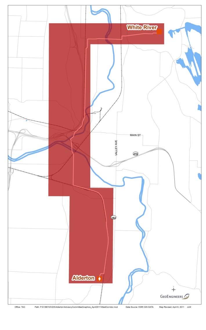
20 White River Transmission Substation
21 East Corridor CONCEPTUAL ROUTE: North of SR 410, parallel to existing corridors: PSE Transmission Williams Natural Gas Pipeline Corridor Roadways South of SR 410, through Sumner- Orting Valley

22 East Corridor Critical Constraints: Dense residential areas Construction and maintenance is difficult on steep slopes Requires extensive tree removal to meet 230 kv vegetation clearing standards Property owners in Sumner/Orting Valley have already been affected by a PSE transmission line project 22

23 East Route - south of White River Station Residences just south of White River Station Existing 115 kv line on 166 th St E


24 East Route Cross country near 164 th Ave. E Sumner- Tapps Hwy
25 Central Corridor CONCEPTUAL ROUTE: Generally parallel with existing transmission lines heading west from White River transmission substation Uses existing 75 easement between Burlington Northern Railroad and East Valley Highway Existing lines on both sides of Valley Ave in Sumner Central Business District Uses existing 80 PSE fee-owned rightof-way on east side of SR 162
26 Central Corridor Critical Constraints: Wetland depression on north end of East Valley Highway Downtown Sumner has zero building setbacks in areas Residences and businesses along Valley Avenue would be affected Vegetation clearing to 230 kv standards may impact landscape trees Widening of SR 162 would be forced to west side of highway or cost of power line relocation falls to WSDOT / taxpayers 26


27 Central Route, north end Looking east up the hill to White River Station Wetland depression: poles located between East Valley Hwy and railroad track


28 Central Route Valley Avenue Existing business district on Valley Ave Transmission lines on both sides of Valley Ave

29 Example of 230 kv construction Example of 230 kv construction on city street in West Seattle 29


30 Central Route SR 162, south of SR 410 Looking South from Pioneer Way Aerial View two PSE transmission lines on east side of SR 162
31 Conceptual design: SR 162, S of Pioneer Way
32 West Corridor CONCEPTUAL ROUTE: Would be built behind warehouse area Would run through Cannery Commercial District Crosses over SR 410 and Puyallup River Parallels Pioneer Way / Foothills Trail
33 West Corridor Critical Constraints: Construction next to drainage stream (warehouse area) is difficult Threading the needle through commercial district, over SR 410, Puyallup River and railroad trestle requires complex design and additional poles Proximity to sensitive areas: Puyallup River Shorelines and Channel Migration Zones Vegetation clearing to 230 kv standards will require some tree removal for river crossings, possibly Foothills Trail corridor 33

34 West Route Warehouse District (conceptual)

35 West Route west side of Warehouse District


36 West Route - Sumner The Cannery / Commercial area looking west Sumner Wastewater Treatment Plant, looking north toward SR 410


37 West Route South of SR 410 New Shaw Road Extension 134 th Avenue East near Annexation area

38 West Route Foothills Trail Off Pioneer Way, looking south (Existing 115 kv line)
39 Conceptual design: Foothills Trail Corridor

40 Alderton Transmission Substation
41 BREAK 41
42 Next Steps Introduce the project to the public in Open House - May 5, 2011, 5 p.m. at Sumner Public Library Continue working with Community and Advisory group to refine transmission line route alternatives Inform stakeholders and property owners of preferred route Begin engineering and environmental studies, permitting and design Construction is anticipated to begin in
43 Contact us Janet Olsen Project Manager Gary Nomensen Government & Community Relations Manager
44 If Asked 44
45 Pierce 230 kv Project 45

46 Example of clearing for new transmission corridor


47 Existing Transmission th Ave E looking North


48 Central Route PSE 75 easement is in a swale between East Valley Hwy. (Dieringer Hwy.) and Railroad Grade.


49 East Valley Highway Looking South into Sumner Industrial Park Area
Electric System Serving Pierce County Current system and future investments. Janet Olsen Steve Botts
 Electric System Serving Pierce County Current system and future investments Janet Olsen Steve Botts Project Manager Real Estate t / Rights-of-Way April 13, 2011 Presentation overview Information requested
C. APPROACH FOR IDENTIFYING THE BEST ROUTES FOR THE NEEDED TRANSMISSION SYSTEM IMPROVEMENTS
 C. APPROACH FOR IDENTIFYING THE BEST ROUTES FOR THE NEEDED TRANSMISSION SYSTEM IMPROVEMENTS CL&P s approach for identifying the best routes for the needed transmission system improvements included a determination
Project Purpose: Project History and Status:
 Plant Unit Substation Improvements Project Purpose: The purpose of this project is to ensure that the portions of the Nine Springs Wastewater Treatment Plant powered by Unit Substations U11, U12, and U13
Representative (s) in Attendance
 in Attendance") Meeting Summary Advisory Group Meeting #6 February 2, 2012 5:30 p.m. to 8:30 p.m. Baymont Inn and Suites, Kirkland, WA Organization Aerojet City of Kirkland, Public Works City of Redmond, Planning Evergreen
Meeting Summary Advisory Group Meeting #6 February 2, 2012 5:30 p.m. to 8:30 p.m. Baymont Inn and Suites, Kirkland, WA Organization Aerojet City of Kirkland, Public Works City of Redmond, Planning Evergreen
Fall 2014 Open House and Feedback Summary
 Fall 2014 Open House and Feedback Summary Overview 12/4/14 Puget Sound Energy (PSE) hosted an online open house from Nov. 3 to Nov. 21, 2014 and two in-person open houses on Nov. 12 and 13. At these open
PROGRESS REPORT WATERFRONT PROGRAM. Q (January - March) Highlights from Q1 2018
 Highlights from Q1 2018") WATERFRONT PROGRAM PROGRESS REPORT Q1 2018 (January - March) Highlights from Q1 2018 Advanced Pier 62 Rebuild construction including completion of Pier 62 demolition in February 2018. Prepared for the
WATERFRONT PROGRAM PROGRESS REPORT Q1 2018 (January - March) Highlights from Q1 2018 Advanced Pier 62 Rebuild construction including completion of Pier 62 demolition in February 2018. Prepared for the
LONG TERM (OPERATION) IMPACTS AND POTENTIAL MITIGATION
 IMPACTS AND POTENTIAL MITIGATION") 3.6 This chapter provides a project-level analysis of potential impacts to recreation sites in the study area including parks, natural areas, open spaces, trails, and playfields, as well as amenities such
3.6 This chapter provides a project-level analysis of potential impacts to recreation sites in the study area including parks, natural areas, open spaces, trails, and playfields, as well as amenities such
Auburn Trail / Ontario Pathways Trail Connector Feasibility Study Public Information Meeting Wednesday, August 22, 2012
 Auburn Trail / Ontario Pathways Trail Connector Feasibility Study Public Information Meeting Wednesday, August 22, 2012 Purpose of Feasibility Study Purpose Evaluate the feasibility of constructing a multiuse
Understanding user expectations And planning for long term sustainability 1
 Understanding user expectations And planning for long term sustainability 1 What is a natural surface trail? It can be as simple has a mineral soil, mulched or graveled pathway, or as developed as elevated
EAST DON TRAIL ENVIRONMENTAL ASSESSMENT. Community Liaison Committee Meeting #3 July 15, :30 to 8:30 pm Flemingdon Park Library
 EAST DON TRAIL ENVIRONMENTAL ASSESSMENT Community Liaison Committee Meeting #3 July 15, 2013 6:30 to 8:30 pm Flemingdon Park Library Agenda 1. Welcome 2. Housekeeping and Updates a) Housekeeping b) CLC
SUMMER VILLAGE OF SILVER SANDS. Municipal Development Plan
 SUMMER VILLAGE OF SILVER SANDS Municipal Development Plan Bylaw 253-2014 Adopted August 22, 2014 Summer Village of Silver Sands Municipal Development Plan Bylaw No. 253-2014 Page 2 1 INTRODUCTION 1.1 SETTING
Sudbury to Hudson Transmission Reliability Project
 An independent assessment of routing options Sudbury to Hudson Transmission Reliability Project and use of a rail-banked corridor for this purpose Prepared by: NorthEast Logistics Systems, LLC August 29,
Appendix L Technical Memorandum Aesthetics
 Technical Memorandum Aesthetics 1.0 AESTHETICS This section provides a discussion of the aesthetic resources in the vicinity of ARTIC. Aesthetics pertain to the elements that make a certain view pleasing
Attachment G STREAM IMPACTS. Ridge Road Extension Alternatives Analysis
 Attachment G STREAM IMPACTS for: Ridge Road Extension Alternatives Analysis PREPARED FOR: Pasco County Engineering Services Department PREPARED BY: NV5, INC. 6989 E. FOWLER AVENUE TAMPA, FLORIDA 33617
Georgetown-Lewes Rail/Trail Study. Rail/Trail Study: Cool Spring to Cape Henlopen State Park New Road Extension (House Resolution No.
 Georgetown-Lewes Rail/Trail Study Rail/Trail Study: Cool Spring to Cape Henlopen State Park New Road Extension (House Resolution No. 47) August 22, 2011 Presentation Outline Background Benefits Statewide
Capilano Substation Upgrade
 Capilano Substation Upgrade Community Engagement Summary MAY 206 NOVEMBER 208 BCH8-278 Contents.0 Introduction............................................................................. 2.0 Methodology...........................................................................
US 380 FEASIBILITY STUDY
 US 380 FEASIBILITY STUDY Denton County CSJ(s): 0135-10-061, 0135-10-062 Public Meeting(s): January 15 & 22, 2019 WELCOME US 380 Denton County Feasibility Study DALLAS DISTRICT PUBLIC MEETING January 15
Auburn Trail/Ontario Pathways Trail Connector Feasibility Study Project Advisory Group Meeting August 25, 2011 Farmington Town Hall Approved Minutes
 Auburn Trail/Ontario Pathways Trail Connector Feasibility Study Project Advisory Group Meeting August 25, 2011 Farmington Town Hall Approved Minutes Committee Members Attending: Ronald L. Brand, Director
White Mountain National Forest
 White Mountain National Forest United States Department of Agriculture Forest Service Eastern Region Boles Brook Snowmobile Bridge Decision Memo Boles Brook Snowmobile Bridge Project Town of Woodstock
I. INTRODUCTION EAST COAST GREENWAY STUDY PURPOSE
 I. INTRODUCTION STUDY PURPOSE The purpose of this study is to determine the engineering feasibility of developing the Eastern Trail. It was initiated at the request of the and funded by the Maine Department
Updated Transmission Expansion Plan for the Puget Sound Area to Support Winter South-to-North Transfers. Approved by PSAST on
 Updated Transmission Expansion Plan for the Puget Sound Area to Support Winter South-to-North Transfers Approved by PSAST on 4-25-11 Overview Why the Update? Proposed Transmission Expansion Plan TCRM &
State Project Reconstruction I-84
 State Project 151-273 Reconstruction I-84 Waterbury, Connecticut FROM WASHINGTON STREET TO PIERPONT ROAD I-84 Constructors J.V. Robert Turner Area Engineer Ken Fargnoli District Engineer John Dunham Assistant
Grade Crossings in High Speed Rail Corridors
 Grade Crossings in High Speed Rail Corridors 59 th ANNUAL ILLINOIS TRAFFIC ENGINEERING & SAFETY CONFERENCE October 21, 2010 Champaign, IL Michael E. Stead Rail Safety Section Illinois Commerce Commission
FY Candidate Sidewalk Projects. Sidewalk Advisory Committee
 FY 18-19 Candidate Sidewalk Projects Sidewalk Advisory Committee Sidewalk Advisory Committee December 2017 FY 18-19 Candidate Sidewalk Projects Old Berkley Road C. Fred Jones Blvd. (CR 559A) to Gapway
Map 1.1 Wenatchee Watershed Land Ownership
 Map 1.1 Wenatchee Watershed Land Ownership Map 1.1 Wenatchee Watershed Land Ownership The Wenatchee watershed lies in the heart of Washington state in Chelan County. Just larger than the state of Rhode
Rockin River Ranch State Park
 Rockin River Ranch State Park Public Meeting No. 3 August 16 th, 2017 Arizona State Parks and Trails (ASPT) Welcome Executive Director Sue Black Park budget = $4 million Balance of recreation uses, environment,
ROUTE ANALYSIS PROCESS
 ROUTE ANALYSIS PROCESS Progress to Date: 1. Recorded and labeled all routes received from PAT Meetings. 2. Determined opportunity, avoidance and exclusion areas crossed by PAT proposed routes. 3. Routes
Longmont to Boulder Regional Trail Jay Road Connection DRAFT FINAL REPORT
 Longmont to Boulder Regional Trail Jay Road Connection DRAFT FINAL REPORT December 2018 Project Summary Boulder County, Colorado, in partnership with the City of Boulder, is evaluating options for multi-use
EXECUTIVE SUMMARY FALL Introduction. Findings
 EXECUTIVE SUMMARY FALL 2004 Introduction Trails are one of the most popular and highly desirable recreational resources in communities of all sizes throughout the country. In addition to providing a safe
China Creek North Park Upgrades and Glen Pump Station. Park Board Committee Meeting Monday, July 10, 2017
 China Creek North Park Upgrades and Glen Pump Station Park Board Committee Meeting Monday, July 10, 2017 Purpose The purpose of this presentation is to: Share the results of the public engagement processes;
Welcome to Public Information Workshop 1. San Francisco International Airport 14 CFR Part 150 Study Update Noise Compatibility Program Report
 Welcome to Public Information Workshop 1 Chetcuti Room, City of Millbrae 450 Poplar Avenue, Millbrae, California 94030 Tuesday, August 11, 2015 7:00 p.m. to 8:00 p.m. PDT A 14 CFR Part 150 Study: Assesses
MORGAN CREEK GREENWAY Final Report APPENDICES
 APPENDICES MORGAN CREEK GREENWAY Appendix A Photos of Existing Conditions in Trail Corridor Photos of existing conditions Main trail corridor - February 2009 Photos of existing conditions south bank Morgan
At the time, the portion of the line through Eagle County remains wholly under the ownership of Union Pacific Railroad (UP).
.") Chapter 5 The Railroad Corridor as a Trail Corridor The intent of this chapter is to identify how the rail corridor, if available for lease or purchase in all or part, could be incorporated into the core
Chapter 5 The Railroad Corridor as a Trail Corridor The intent of this chapter is to identify how the rail corridor, if available for lease or purchase in all or part, could be incorporated into the core
Memorandum. Federal Aviation Administration. Date: June 19, Richard Doucette, Environmental Protection Specialist. From: To:
 Federal Aviation Administration Memorandum Date: June 19, 2008 From: To: Subject: Richard Doucette, Environmental Protection Specialist LaVerne Reid, Airports Division Manager John Donnelly, Regional Counsel
Hospital Link Project Project Update Winter 2018
 Hospital Link Project Project Update Winter 2018 General The project provides a link from Riverside Drive and the Transitway to the Hospital Link Road. Construction of the Hospital Link facility is open
2015 PURDUE ROAD SCHOOL March 11, 2015
 2015 PURDUE ROAD SCHOOL March 11, 2015 Runway Protection Zone (RPZ) Definition It is a trapezoidal shape formed off the end of a runway and its geometry it a function of the airport s aircraft approach
FEASIBILITY CRITERIA
 This chapter describes the methodology and criteria used to evaluate the feasibility of developing trails throughout the study areas. Land availability, habitat sensitivity, roadway crossings and on-street
2016 Regional Transportation Alternatives Program (TAP) Grant Application
 Grant Application") 2016 Regional Transportation Alternatives Program (TAP) Grant Application PROJECT TITLE: Yelm-Tenino Trail Extension Feasibility Study TRPC use only GENERAL PROJECT INFORMATION Agency or Organization City
2016 Regional Transportation Alternatives Program (TAP) Grant Application PROJECT TITLE: Yelm-Tenino Trail Extension Feasibility Study TRPC use only GENERAL PROJECT INFORMATION Agency or Organization City
SR 934 Project Development And Environment (PD&E) Study
 Study") SR 934 Project Development And Environment (PD&E) Study Project Advisory Group Meeting March 1, 2018 State Road 934/NE/NW 79th Street from west of I-95 (NW 13th CT) to N. Bayshore Drive PD&E STUDY SR 934/NE/NW
SR 934 Project Development And Environment (PD&E) Study Project Advisory Group Meeting March 1, 2018 State Road 934/NE/NW 79th Street from west of I-95 (NW 13th CT) to N. Bayshore Drive PD&E STUDY SR 934/NE/NW
Roduner Ranch FOR SALE. 5,878± Acres Potential Development Land. Merced County, California. Offices Serving The Central Valley
 FOR SALE 5,878± Acres Potential Development Land Merced County, California Offices Serving The Central Valley F R E S N O V I S A L I A B A K E R S F I E L D 7480 N. Palm Ave, Ste 101 3447 S. Demaree Street
Roberts Bank Terminal 2 Project Project Definition Consultation Consultation Summary Report: Appendix 1 Invitation and Newspaper Advertisement
 Consultation Summary Report: Appendix 1 Email Invitation and Newspaper Advertisement Port Metro Vancouver provided notice of opportunities to participate in through multiple channels, including email and
Welcome to the Cross County Trail Public Input Session!
 Welcome to the Cross County Trail Public Input Session! Please sign in on the table below! What are we doing here? Camden County has proposed a bicycle and pedestrian trail spanning across the entire county.
WELCOME to the Iditarod Dog Sledding Historic District (IDSHD) Workshop. January 11, Houston Middle School Houston, Alaska
 Workshop. January 11, Houston Middle School Houston, Alaska") WELCOME to the Iditarod Dog Sledding Historic District (IDSHD) Workshop January 11, 2012 Houston Middle School Houston, Alaska Workshop Purpose: Present/discuss proposed resolutions to comments received
WELCOME to the Iditarod Dog Sledding Historic District (IDSHD) Workshop January 11, 2012 Houston Middle School Houston, Alaska Workshop Purpose: Present/discuss proposed resolutions to comments received
PRESENTED TO Town of Middlebury, VT. PRESENTED BY VTrans, VHB, Fitzgerald & Halliday, Inc., and Kubricky Construction
 PRESENTED TO Town of Middlebury, VT PRESENTED BY VTrans, VHB, Fitzgerald & Halliday, Inc., and Kubricky Construction Meeting with you today Brian Carpenter, Middlebury Selectboard Chair Jim Gish, Middlebury
Tillamook to Oceanside Transmission Line (TOTL) Siting Process Citizen Advisory Group (CAG) Debra Nudelman and Annie Kilburg, Kearns & West
 Siting Process Citizen Advisory Group (CAG) Debra Nudelman and Annie Kilburg, Kearns & West") March 11, 2015 MEMORANDUM TO: FROM: Tillamook to Oceanside Transmission Line (TOTL) Siting Process Citizen Advisory Group (CAG) Debra Nudelman and Annie Kilburg, Kearns & West SUBJECT: Tillamook to Oceanside
March 11, 2015 MEMORANDUM TO: FROM: Tillamook to Oceanside Transmission Line (TOTL) Siting Process Citizen Advisory Group (CAG) Debra Nudelman and Annie Kilburg, Kearns & West SUBJECT: Tillamook to Oceanside
Table of Contents. Master Plan March 2014 TOC i Spokane International Airport
 Table of Contents Page Chapter 1 Inventory 1. Introduction... 1 1 1.1 Community Profile... 1 2 1.1.1 Location and Setting... 1 1 1.1.2 Climate... 1 2 1.1.3 Socioeconomic Conditions... 1 5 1.1.4 Area Land
CITY PLANNING COMMISSION AGENDA ITEM NOS: 5.A, 5.B STAFF: MICHAEL SCHULTZ
 CPC Agenda Page 83 CITY PLANNING COMMISSION AGENDA ITEM NOS: 5.A, 5.B STAFF: MICHAEL SCHULTZ FILE NO(S): CPC DP 03-00259-A5MN11 QUASI-JUDICIAL AR NV 11-00538 QUASI-JUDICIAL PROJECT: BROADMOOR TEMPORARY
I-75 in Hamilton County Project Termini
 I-75 in Hamilton County Project Termini Introduction As part of the North South Transportation Initiative (NSTI), capacity improvements were recommended for the I-75 corridor through Hamilton County from
Ditch flows slowly to the north
 Ditch flows slowly to the north Photo 1. Wetland DE: Looking west across Wetland DE from upslope. Ponded water, mucky mineral soils, and patches of emergent vegetation observed. Wetland DE appears to be
Engagement Summary Report. Trans-Canada Highway 1 RW Bruhn Bridge Replacement Project. Community Engagement November 15, 2016 to January 15, 2017
 Trans-Canada Highway 1 RW Bruhn Bridge Replacement Project Community Engagement November 15, 2016 to January 15, 2017 Engagement Summary Report February 2017 Prepared by Kirk & Co. Consulting Ltd. Trans-Canada
Proposed At-grade Crossings of Officially Recognized Trails Port MacKenzie Rail Extension Project
 Proposed At-grade Crossings of Officially Recognized Trails Port MacKenzie Rail Extension Project 1.0 Introduction On November 21, 2011 the Surface Transportation Board (STB) issued a final decision (Docket
Appendix D Project Newsletters. Tacoma Narrows Airport. Master Plan Update
 Appendix D Project Newsletters Tacoma Narrows Airport Master Plan Update This appendix contains the newsletters distributed throughout the project. These newsletters provided updates and information on
Quiet Zone Evaluation for Huron, Ohio
 Quiet Zone Evaluation for Huron, Ohio 9601 Camp Bowie West Fort Worth, TX 76116 +1 817 886 8210 (T) www.ctcinc.com Quiet Zone Evaluation City of Huron, OH Final Report August 2015 Introduction The City
KP Lasnaya 1 River
 KP 370.2 Lasnaya 1 River The Lasnaya 1 River crossing is protected by Reno mattings and a gabion wall on the north bank (Photo 1). The south bank consists of natural river gravel deposits on top of Reno
2. Goals and Policies. The following are the adopted Parks and Trails Goals for Stillwater Township:
 D. PARKS AND TRAILS 1. Introduction Stillwater Township s population is relatively low, with most residents living on rural residences on large lots. The need for active park space has been minimal in
Supplemental Information for Application for Transportation and Utility Systems and Facilities on Federal Lands
 Supplemental Information for Application for Transportation and Utility Systems and Facilities on Federal Lands Introductory Note: This application is filed by PATH Allegheny Transmission Company, LLC
Trail Feasibility Study
 VOLUSIA COUNTY MPO CITY OF NEW SMYRNA BEACH FINAL REPORT JUNE 30, 2009 Trail Feasibility Study What s inside? 1 Introduction 2 Project Purpose & Scope 3 Physical Inventory & Assessment of Right-of- Way
Thornton Water Project. Larimer County Route Study and Project Update September 12, 2017
 Thornton Water Project Larimer County Route Study and Project Update September 12, 2017 Purpose of Meeting Provide information on the Thornton Water Project Present the results of the pipeline routing
CHAPTER 4 -- THE LAND USE PLAN: DESCRIPTIONS AND POLICIES FOR THIRTEEN PLANNING AREAS
 CHAPTER 4 -- THE LAND USE PLAN: DESCRIPTIONS AND POLICIES FOR THIRTEEN PLANNING AREAS NORTH CENTRAL CAC AREA LITTLE VALLEY ROAD TO JUG HANDLE CREEK PLANNING AREA This planning area includes Cleone, Noyo,
Blue River Trail Master Plan JSA to Town Hall June 2004
 Blue River Trail Master Plan JSA to Town Hall June 2004 Prepared for: Silverthorne Town Council Silverthorne SPORT Committee Department of Recreation and Culture Silverthorne Public Works Silverthorne
Airport Planning Area
 PLANNING AREA POLICIES l AIRPORT Airport Planning Area LOCATION AND CONTEXT The Airport Planning Area ( Airport area ) is a key part of Boise s economy and transportation network; it features a multi-purpose
Citrus Heights Creek Corridor Trail Project. Trail Advisory Group Meeting #3 July 8, 2013
 Citrus Heights Creek Corridor Trail Project Trail Advisory Group Meeting #3 July 8, 2013 Agenda Introductions Recap: Community Workshop, Survey Findings, and TAG Field Trip Community Concern Discussion:
RAILS WITH TRAILS ALBANY TO CORVALLIS PEDESTRIAN AND BICYCLE PATH FEASIBILITY STUDY
 RAILS WITH TRAILS ALBANY TO CORVALLIS PEDESTRIAN AND BICYCLE PATH FEASIBILITY STUDY September 2004 Benton County Public Works Chuck Knoll, P.E., Senior Engineer Andrew Monaco, GIS Analyst and Maps Mark
1803 West Hwy 160 Monte Vista, CO (719) TTY (719)
 TTY (719)") USDA Forest Service Rio Grande National Forest http://www.fs.fed.us/r2/riogrande 1803 West Hwy 160 Monte Vista, CO 81144 (719)852-5941 TTY (719)852-6271 USDI Bureau of Land Management San Luis Valley Center
USDA Forest Service Rio Grande National Forest http://www.fs.fed.us/r2/riogrande 1803 West Hwy 160 Monte Vista, CO 81144 (719)852-5941 TTY (719)852-6271 USDI Bureau of Land Management San Luis Valley Center
1 PROJECT STATUS UPDATE 2 ND CONCESSION FROM BRISTOL ROAD TO DOANE ROAD TOWNS OF EAST GWILLIMBURY AND NEWMARKET
 Report No. 3 of the Regional Council Meeting of March 28, 2013 1 PROJECT STATUS UPDATE 2 ND CONCESSION FROM BRISTOL ROAD TO DOANE ROAD TOWNS OF EAST GWILLIMBURY AND NEWMARKET The recommends: 1. Receipt
Mohawk Hudson Bike Hike Trail Crossroad Connection Study
 Summary Report - April 21, 2003 Mohawk Hudson Bike Hike Trail Crossroad Connection Study Summary Report Introduction The Capital District Transportation Committee (CDTC), in partnership with Albany County,
Portable Noise Monitor Report
 Portable Noise Monitor Report Chicago O Hare International Airport Site 2117 5843 N. Christiana Avenue, Chicago July 14, 217 through August 2, 217 USH5-ILH15-ILS8-CHI39 Visit the O Hare Noise webpage on
Master Plan & Noise Compatibility Study Update
 Working Document-Subject to Change, March 2010 Master Plan & Noise Compatibility Study Update (14 CFR Part 150) TECHNICAL ADVISORY COMMITTEE March 24, 2010 Working Document-Subject to Change, March 2010
Federal Aviation Administration. Airport Land Use Compatibility Advisory Circular ACI-NA / FAA. FAA HQ Washington, DC March 27, 2013
 Airport Land Use Compatibility Advisory Circular ACI-NA / FAA FAA HQ Washington, DC March 27, 2013 The purpose of this meeting is to discuss FAA s update of the Airport Compatible Land Use Advisory Circular.
Railroad Safety Trail
 2.1 INTRODUCTION AND PROJECT SETTING 2.1 Introduction & Project Setting Introduction This study is the result of a directed effort on the part of the City of San Luis Obispo to carry out previously established
Third Parties/Crossing
 Third Parties/Crossing Presentation by Bill Scheers Canadian Association of Petroleum Land Administration Surface Land Administration Advisory Committee November 29, 2011 Agenda EAPUOC Guide for Working
Public Notice ISSUED: December 10, 2018 EXPIRES: January 9, 2019
 APPLICANT: REFER TO: St. Louis and Lake Counties Regional Rail Authority 2018-01942-ARC Public Notice ISSUED: December 10, 2018 EXPIRES: January 9, 2019 SECTION:404 - Clean Water Act 1. APPLICATION FOR
U.S. ROUTE 202 SECTION 300 IMPROVEMENT PROJECT East Whiteland Township Tredyffrin Township Chester County
 U.S. ROUTE 202 SECTION 300 IMPROVEMENT PROJECT East Whiteland Township Tredyffrin Township Chester County TMACC Information Session January 24, 2011 U.S. Route 202 Section 300 Project Limits U.S. ROUTE
Donnybrook Precinct Structure Plan Utilities Servicing and Infrastructure Assessment
 Donnybrook Precinct Structure Plan Utilities Servicing and Infrastructure Assessment Project Number: CG130061 Prepared for Metropolitan Planning Authority 4 September 2014 Donnybrook Precinct Structure
Port Gamble Shoreline Area Conceptual Trail Proposal
 The North Kitsap Trails Association is pleased to be a partner to the Kitsap Forest and Bay Project and assist Kitsap County, Forterra, Olympic Property Group, Great Peninsula Conservancy and the Port
Airport Land Use Compatibility Plan (ALUCP) Update. Public Information Meeting #4 June 8 & 9, 2016
 Update. Public Information Meeting #4 June 8 & 9, 2016") Airport Land Use Compatibility Plan (ALUCP) Update Public Information Meeting #4 June 8 & 9, 2016 Agenda 1. Study Process 2. Noise Complaint Patterns 3. Proposed Overflight Areas (AOA) 4. Proposed Land
Airport Land Use Compatibility Plan (ALUCP) Update Public Information Meeting #4 June 8 & 9, 2016 Agenda 1. Study Process 2. Noise Complaint Patterns 3. Proposed Overflight Areas (AOA) 4. Proposed Land
ANCLOTE COASTAL TRAIL ALTERNATIVES ANALYSIS STUDY
 ANCLOTE COASTAL TRAIL ALTERNATIVES ANALYSIS STUDY PASCO COUNTY MPO JULY 2015 PROJECT OVERVIEW... INTRODUCTION EXECUTIVE SUMMARY CONTEXT... TAMPA BAY AREA, PINELLAS, & PASCO COUNTY S MULTI-USE TRAIL PLANS
David Johnson. Tom, Attached please find the final scoping letter and figures for your review. David
 David Johnson From: Sent: To: Cc: Subject: Attachments: David Johnson Tuesday, April 12, 2011 4:33 PM Thomas Malecek Dave Dyer; Jason Marks (jmarks@segroup.com) VWC Scoping Letter
Whittier Bridge Project
 Amesbury / Newburyport / Salisbury Whittier Bridge / I-95 Improvement Project Original Whittier Bridge Proposed Whittier Bridges 10/21/2016 Whittier Bridge Project 1 Project Description The project limits
San Mateo County Transportation Authority Board Meeting November 2, 2017 Item #10 1
 San Mateo County Transportation Authority Board Meeting November 2, 2017 Item #10 1 OVERVIEW Brief recap from October Traffic Analysis Findings Draft Environmental Document Summarized Outcomes Questions
Portable Noise Monitor Report
 Portable Noise Monitor Report Chicago O Hare International Airport Site 2114 5516 N. Neenah Avenue, Chicago July 12, 217 through August 9, 217 USH5-ILH19-ILS1-CHI45 Visit the O Hare Noise webpage on the
Welcome Land Use Element... LU-1
 Welcome Land Use Element... LU-1 Land Use Plan... LU-3 Residential Land Uses... LU-12 Commercial Land Uses... LU-14 Mixed Use... LU-16 Industrial Land Uses... LU-18 Automobile-Related Land Uses... LU-19
Portable Noise Monitor Report
 Portable Noise Monitor Report Chicago O Hare International Airport Site 299 93 Wilshire Avenue, Elk Grove Village June 27, 217 through July 1, 217 USH8-ILH55-ILS28 Visit the O Hare Noise webpage on the
LAS VARAS RANCH CA COASTAL TRAIL PROPOSED ALIGNMENT
 LAS VARAS RANCH CA COASTAL TRAIL PROPOSED ALIGNMENT Santa Barbara Trails Council * Prepared by Ray Ford February 1,2012 The following notes accompany the Santa Barbara Trails Council map for the Las Varas
Trail # NW Tuesday, June DESIGN. Provide an Review the Provide an. Project Goals: System system. wayfinding
 I. Welcome / Introductions Bethany Creek Trail #2 Segment 3 Neighborhood Meeting #1 Bethany Presbyterian Church 15505 NW Springville Road, Portland, OR 97229 Tuesday, June 26, 2018 @ 6:00PM Meeting Minutes
New 55-Dogpatch Outreach Findings & Route Development
 Executive Summary Based on outreach conducted through Spring of 2018, the SFMTA identified a set of three alternative routes and service plans for a new 55-Dogpatch route. These alternatives respond to
Northeast Quadrant Distinctive Features
 NORTHEAST QUADRANT Northeast Quadrant Distinctive Features LAND USE The Northeast Quadrant includes all the area within the planning area that is east of Interstate 5 and to the north of State Route 44.
APPENDIX E LYONS PARK ESTATES DETAILED COMMUNITY ASSESSMENT RESULTS
 # Houses: 65 APPENDIX E LYONS PARK ESTATES DETAILED COMMUNITY ASSESSMENT RESULTS Overall Risk Assessment: High Description: Lyons Park Estates is located on the foothills south of the town of Lyons on
Presentation Overview
 DON NARROWS Historical and Existing Conditions March 29, 2008 Presentation Overview 1. Project Location and Background 2. Historical Context How did the Don Narrows Come to Be? 3. The Today 4. Next Steps
Energex Loganlea to Jimboomba Network Upgrade Response to Supplementary IAR. Closes 8 April Submission by
 Energex Loganlea to Jimboomba Network Upgrade Response to Supplementary IAR Closes 8 April 2010 Submission by Logan and Albert Conservation Association Prepared by Anne Page (BA Hons Dip Ed M Env Mgt)
PORT OF SEATTLE MEMORANDUM. COMMISSION AGENDA Item No. 4g ACTION ITEM Date of Meeting February 9, 2016
 PORT OF SEATTLE MEMORANDUM COMMISSION AGENDA Item No. 4g ACTION ITEM Date of Meeting February 9, 2016 DATE: TO: FROM: Michael Ehl, Director, Airport Operations Wayne Grotheer, Director, Aviation Project
PULLMAN-MOSCOW REGIONAL AIRPORT Runway Realignment Project
 PULLMAN-MOSCOW REGIONAL AIRPORT Runway Realignment Project GENERAL AIRPORT INFORMATION AIRPORT USERS Airport ownership: Public, owned by the Pullman-Moscow Regional Airport Board Year opened: February
4.0 Context for the Crossing Project
 4.0 Context for the Crossing Project This section provides background information about key features of the North Douglas Crossing project area, and opportunities and constraints. This information is important
Project Overview. Hunter Mill Road Over Colvin Run Bridge Replacement Fairfax County. Get Involved. Public Information Meeting. Contact Information
 Get Involved VDOT representatives will review and evaluate any information received as a result of the public information meeting. The comment sheet in this brochure is provided to assist in making your
Northern Rail Extension, Phase One
 General Project and Funding 1. Where does Phase One start? The rail line for Phase One begins roughly at the northern boundary of the former Bradbury property, but also includes work along Tom Bear Trail
Project Deliverable 4.1.3f Individual City Report - City of San Dimas
 Pomona Valley ITS Project Project Deliverable 4.1.3f Individual City Report - City of San Dimas Prepared by: April 19, 2002 099017000.1 Copyright 2002, Kimley-Horn and Associates, Inc TABLE OF CONTENTS
Classifications, Inventory and Level of Service
 Classifications, Inventory and Level of Service Section 3 Kenmore Park, Recreation and Open Space Plan 1 P a g e Classifications and Inventory Park Classifications Kenmore classifies its parks based upon
Citrus Heights Creek Corridor Trail Project Trail Advisory Group Field Trip #2 September 11, :00 11:00 am Trellis Hall, Citrus Heights
 September 11, 2013 9:00 11:00 am Trellis Hall, Citrus Heights Project Overview The City of Citrus Heights is studying the feasibility of establishing a multi use trail system within the City s 26 miles
Grounding Clamp. Pins and Ball-Socket Clamps for Temporary Grounding
 Grounding Clamp Pins and Ball-Socket Clamps for Temporary Grounding Pins and Ball-Socket Clamps have been designed to solve several temporary grounding situations, where the physical space or the contact
Welcome to the Illinois High-Speed Rail Chicago to St. Louis Construction Update Meeting. Today s meeting will provide an overview of the Program,
 Welcome to the Illinois High-Speed Rail Chicago to St. Louis Construction Update Meeting. Today s meeting will provide an overview of the Program, updates on construction to be held in this area, and how