Community Parks & Recreation Plan Laketown Township
|
|
|
- Solomon Morrison
- 5 years ago
- Views:
Transcription


1 2018 Community Parks & Recreation Plan Laketown Township
2 2
3 RESOLUTION... 5 COMMUNITY LOCATION AND DESCRIPTION... 7 COMMUNITY DEMOGRAPHICS... 9 Historic Population Growth... 9 Population by Race Population by Age Population Projections ADMINISTRATIVE STRUCTURE Board of Trustees Parks and Recreation Commission Building Authority Planning Commission Staff THE PLANNING PROCESS PARKS AND PATHWAYS RECREATION INVENTORY Lakes: Gilligan Lake Goshorn Lake Kelly Lake Nature Preserve: Dune Pines Nature Preserve, 4580 Audubon Rd Pathways: Non-Motorized paths US Bike Route Rest Area: MDOT Rest Area State Park: Saugatuck Dunes State Park, th Ave Township Parks: Farview Park, th Ave Historic Town Hall, nd Ave Huyser Farm, th St
4 Laketown Beach, nd St Sanctuary Woods, th St Shore Acres, th Ave Township Hall Recreation Complex, 4338 Beeline Rd Wolters Woods, th Ave COMMERCIAL RECREATIONAL OPPORTUNITIES IN THE TOWNSHIP COMMERCIAL RECREATIONAL OPPORTUNITIES W/IN FIVE MILES PUBLIC/NONPROFIT RECREATIONAL OPPORTUNITIES W/IN FIVE MILES PUBLIC/PRIVATE SCHOOLS PROGRAMMING OUTREACH Adopt-A-Park Program Park Exploration Days with the Outdoor Discovery Center (ODC) Parks Reservation Use Application Wildlife and Vegetation Inventories and Brochures LONG TERM GOALS ACTION PROGRAM Farview Historic Town Hall Huyser Farm Laketown Beach Land Acquisition Non-motorized Paths Park Master Planning and Development Sanctuary Woods Shore Acres Park Shore Acres Farm Township Hall Recreation Area Wolters Woods CAPITAL IMPROVEMENT PROGRAM APPENDICES Appendix A Notice of Public Hearing Appendix B Laketown Township Street Index Map Appendix C Laketown Township 2006 Existing Land Use Map
5 Appendix D Laketown Township 2006 Future Land Use Map Appendix E Laketown Township 2006 Natural Features Map Appendix F Laketown Township Downtown Development Area Zoning Map Appendix G Needs Assessment Survey Appendix H Laketown Township Map of Parks and Pathways Appendix I Laketown Township Non-Motorized Path Plan Appendix J Huyser Farm Concept Plan Appendix K Recreation Complex Concept Plan Appendix L Park Exploration Days with the ODC Appendix M Adopt-A-Park Program Appendix N Parks Reservation Use Application Appendix O The 2012 Felt Estate Shore Acres Farm Master Plan Special thanks to Mike Lozon/Freestyle Photography for his many contributions to this publication. 5
6 RESOLUTION RESOLUTION WHEREAS, the Laketown Parks and Recreation Commission has been formed by the Township Board of Trustees action pursuant to the Michigan Public Act 271 of 1921, as amended, and WHEREAS, it has been deemed in the best interest of all residents of Laketown Township to prepare and establish a concise and realistic program to provide for the recreational opportunities of these citizens, and WHEREAS, the Laketown Township Parks and Recreation Commission has developed this plan, and WHEREAS, the 2018 Laketown Township Community Parks and Recreation Plan has been formally transmitted to the Township Board of Trustees for comment and review and has been presented to the Township residents at the September 20, 2017 public hearing held at the regular monthly meeting of the Parks and Recreation Commission, and WHEREAS, the 2018 Laketown Township Community Parks and Recreation Plan has been formally transmitted to the Allegan County Planning Commission, the West Michigan Regional Planning Commission and the Michigan Department of Natural Resources for comment and review, NOW THEREFORE BE IT RESOLVED, that the Laketown Township Board of Trustees does herewith adopt the 2018 Laketown Township Community Parks and Recreation Plan. CERTIFICATE I, the undersigned, the Clerk of the Township of Laketown, Allegan County, Michigan, do hereby certify that the foregoing is a true and complete copy of the resolution adopted by the Township Board at a regular monthly meeting held on the 11 th day of October, I do further certify that the public notice of said meeting was given pursuant to and in full compliance with Michigan Act 267 of 1976, as amended, and that the minutes of said meeting were kept and will be or have been made available as required by said Act. Wendy Van Huis, Township Clerk 6

7 COMMUNITY LOCATION AND DESCRIPTION Laketown Township is located in the northwestern corner of Allegan County, approximately 35 highway miles southwest of the City of Grand Rapids. Bordered by Lake Michigan on the west, neighboring communities include the City of Holland and Park Township to the north, Fillmore Township to the east, and Saugatuck Township to the south. See Appendix items: Street Index Map B, 2006 Existing Land Use Map C, 2006 Future Land Use Map D, 2006 Natural Features Map E. The prevailing westerly winds over Lake Michigan exert a significant influence and cause the climate to vary between semi-marine and continental in nature. Temperature extremes vary from a mean monthly maximum of 71 degrees Fahrenheit (F.) in July to a mean monthly minimum of 25 degrees (F.) in January, while the mean yearly temperature is 49 degrees (F.). The area experiences an average of 35 inches of precipitation a year, which is uniformly distributed throughout the year. Snowfall amounts average approximately 70+ inches annually. Soils in the township vary from deep, well-drained sand along Lake Michigan to deep, well-topoorly drained sands in the central part of the township to deep, well-to-poorly drained loams in the eastern part of the township. In general, the topography is characterized by a line of high dunes along the Lake Michigan shoreline and gently rolling terrain away from the shoreline area. Basically an agricultural and rural residential community, the residential development is 7
8 concentrated in the areas adjacent to the City of Holland and along Lake Michigan in the northern part of the Township. A limited amount of commercial development is generally confined to the area along Blue Star Highway in the southeastern portion of the township. The Blue Star Highway corridor is the location of the township s Downtown Development area. The watercourses are located in the community as follows: Lake Michigan forms the western boundary of the township; Kelly Lake and Tibbie (Kelly) Drain are in the northwestern corner; Hulst Lake (Gilligan Lake) and Hulst Lake Outlet are in the west-central area; Carver Drain is in the southwestern area; Goshorn Lake is on the southern corporate boundary; Goshorn Lake Inlet is in the southern part; and tributaries are in the northeastern part of the township. 8
9 COMMUNITY DEMOGRAPHICS The majority of the township is white although specific attention should be given to needs of nonwhites when grouped with other minorities such as low-income residents and the elderly. Sensitive community recreation planning can help the township maintain its high quality of life and provide opportunities for every segment of the population. The Township experienced significant population growth from 1980 to 2000 due to an influx of residential growth, and in the next decade saw a slight decline as well as shift to an aging population. These trends will need to be monitored in order to continue to provide for the recreational opportunities for each segment. Historic Population Growth Population growth in the township was fairly consistent from 1950 to 1970, then witnessed a substantial increase from 1970 to 1980 in which the population doubled from 2,175 to 4,332 residents according to U.S. Census Bureau data. From 1980 to 2000, the township experienced a 28% increase in growth to 5,561 residents. With the difficult economy at the end of the decade, the area experienced a slight loss of population. The 2010 Census placed the population at 5,505. The population changes are likely due to several factors. The I-196 freeway from Grand Rapids to Holland provided access to rural areas of the township and decreased travel time to and from metropolitan areas. During the last decade suburban trends continued as large tracts of buildable land in Laketown Township and the adjoining townships became easily accessible to the major urban employment centers. Table 1 indicates how the population growth relates to the surrounding area. The 50-year population change compared to other local jurisdictions indicates large amounts of growth in the lakeshore communities where the desirability for residential development is greater. This contrasts to urban areas, such as the cities of Holland and Saugatuck, and Fillmore Township, which experienced much less longterm growth. Laketown Township tripled its population from , a rate which reflects the steadily increasing growth that has occurred in the area as a whole. Another factor which may have had a less visible effect on the population spurt in the 1970s and 1980s was that many "baby boomers" had married and were having children. Table 1 Historic Population Laketown Township and Surrounding Areas % Change Laketown Township 1,814 2,175 4,332 4,888 5,561 5, % City of Saugatuck 927 1,022 1, , % Saugatuck Twp* 1,735 2,065 2,701 2,916 3,590 2,944 70% Fillmore Township 1,877 2,126 2,307 2,710 2,756 2,681 43% Park Township 4,4043 6,461 10,354 13,541 17,579 17, % Holland Township 6,498 8,455 13,739 17,523 28,911 35, % City of Holland 24,777 26,479 26,281 30,745 35,048 33,051 33% Allegan County 57,729 66,575 81,555 90, , ,408 93% Ottawa County 98, , , , , , % *Includes City of Village of Douglas in 2000 and prior years Sources: U.S. Bureau of the Census 9
10 Population by Race Table 2 below indicates that the population is predominately White, with small percentages of other races. Park Township and the neighboring Allegan County townships have largely the same racial makeup, while the City of Holland and Holland Township have a more racially diverse population. Table 2 Population by Race Laketown Township and Surrounding Area, 2010 # / % White Black American Indian Asian Other Hispanic any race Laketown Twp. 5,243 / / / / / / 4.7 Park Twp. 16,421 / / / / / 4.5 1,403 / 8.0 Saugatuck Twp. 2,824 / / / / / / 4.6 Fillmore Twp. 2,483 / / / / / / 6.5 Holland Twp. 26,180 / / / 0.5 3,346 / 9.4 4,994 / ,347 / 23.4 Holland City 26,457 / ,187 / / / 3.0 3,807 / 9.3 7,512 / 22.7 Saugatuck City 884 / / / / / / 3.8 Allegan County 103,513 / ,358 / / / 0.6 5,253 / 4.7 7,454 / 6.7 Ottawa County 237,638 / ,874 / 1.5 1,104 / 0.4 6,738 / ,410 / 5.5 2,2761 / 8.6 Source: U.S. Bureau of the Census, Population by Age The age of township residents provides an indication of economic, transportation, recreational and other current community needs and how these will change as the population changes. Analysis of age may also give an indication of the effect of migration. The Township's 2010 population was categorized by age groups and compared with the 1990 and 2000 population, as shown in Table 3. The median age for Laketown was 46.8 in 2010, older than Allegan County (39.2 years) and older than the State of Michigan (38.9 years). Table 3 Population By Age Laketown Township Age Groups 1990 % of Total 2000 % of Total 2010 % of Total Under % % % % % % % % % % % % % % % % % 1, % % % % 65 and over % % % Total 4, % 5, % 5, % 10
11 Source: U.S. Bureau of Census, 1990, 2000 & 2010 Laketown Township has been experiencing a shift in population age during the last two decades. The township went from a younger average population to an older average population. A large increase occurred in the population over 45 years old. This age group went from 24.1% in 1990 to 53% in Another significant change was in the 25 to 34 age group. This group dropped from 19.8% in 1990 to just 7.6% in The aging of the population may have an effect on the recreation planning. Another interesting change was in the number and size of households. In 2010 there were 2,248 occupied housing units, compared to 2,080 in This represents an 8% increase in the number of occupied housing units, though the population decreased by 1%. Population Projections The population projections shown in Table 4 were prepared by the Regional West Michigan Planning Commission, our local regional planning organization. Projection methods vary greatly and can include any number of variables such as net migration and natural increase, utility hook-ups, building permits, and employment variables. Mathematical projection methods using past data are also popular. A combination of all methods as opposed to a single technique may be the best method. Although the reliability of any projection method is questionable, a reasonable population outlook for the future can be achieved. Population growth in the township in the next 10 years (Table 3) is projected to grow by approximately 10%. New, large-scale employment centers for industrial or commercial/retail uses are not likely to be developed since the land available for large development projects is restricted due to natural features (poor soils, wetlands, sand dunes, etc.), zoning, highway access, and the lack of available utilities. Any large parcels that meet the criteria for large industrial, commercial, or retail uses would likely be in much greater demand for residential development, with the exception of some parcels near the highway interchange and the Blue Star Highway corridor. The township has created a Downtown Development Area in which some commercial development is expected (see Appendix item F). With demand for residential property as the major factor for population growth, the number of commercial and industrial employment centers will be small. Therefore, the employment opportunities created by new industrial, retail or commercial will account for only a small amount of the population growth. Table 4 Population and Population Projections Laketown Township and Surrounding Areas Projected 2025 Projected 2030 Projected 50 Year Change Laketown Township 4,332 4,888 5,561 5,505 6,051 6,325 6,598 52% Fillmore Township 2,307 2,710 2,756 2,681 2,732 2,757 2,783 21% Park Township 10,354 13,541 17,579 17,802 20,604 22,005 23, % Holland Township 13,739 17,523 28,911 35,636 47,543 53,496 59, % City of Holland 26,281 25,086 35,048 33,051 34,083 34,598 35,114 34% Sources: U.S. Bureau of the Census; 2020, 2025 & 2030 Projections, West Michigan Regional Planning Commission 11
12 ADMINISTRATIVE STRUCTURE The administrative structure of the Township as it relates to recreation (noted below) was developed in order to maximize recreational opportunities available to residents, increase collaboration with neighboring communities and non-profit entities, and minimize redundancy and expense. Following is a description of each segment of this administrative structure and how they serve the electors. Board of Trustees The Board of Trustees annually approves the Parks and Recreation Commission budget. PARKS AND RECREATION COMMISSION BUDGET FY2017 Supplies $ 2,000 Electricity $ 300 Maintenance $ 35,000 Contracted Services $ 5,000 Capital Outlay $ 40,000 Park Development $ 21,941 Bike Path Bond $ 55,890 Bike Path Maintenance $ 11,000 Salaries $ 4,000 FICA $ 300 Department Total $ 175,431 Parks and Recreation Commission The Laketown Township Parks and Recreation Commission was created pursuant to Act 271 of Michigan Public Acts of 1921, as amended. This Act gives the Parks and Recreation Commission authority to acquire, maintain, manage, and control the parks and places of recreation, consistent with the degree of funding allocated by the Township Board. The Parks and Recreation Commission develops the recreation plan and subsequent grant applications. 12
13 Building Authority The Laketown Township Building Authority was formed in 1996 to oversee the acquisition and demolition of the former Michigan Dunes Correctional Facility. This property was acquired from the State of Michigan and converted to public use. In 2007, the Building Authority sold a $500,000 bond to assist in the restoration of the Felt Mansion which the State had turned into office space during its ownership of the facility. The Mansion is regularly used for both public and private events including community festivals, business meetings, and weddings. The Building Authority worked with the Michigan Department of Natural Resources to rejoin the original outbuildings of the Felt Estate to the mansion property through a long term lease. This will allow for the development of Shore Acres Farm. Planning Commission The Laketown Township Planning Commission was created pursuant to Act 168 of Michigan Pubic Acts of 1959, as amended. This Act does not give specific authority to the Planning Commission in the area of recreation. Since recreation planning includes land use planning, the input of the Planning Commission has been recognized as invaluable. Staff A township manager is hired by the Board of Trustees. The manager hires staff for the responsibility of day-to-day contact with citizens, park maintenance, grant administration, and advising the Parks and Recreation Commission. 13
14 THE PLANNING PROCESS The Laketown Township Parks and Recreation Commission is dedicated to providing and maintaining a park, trail, and open space system including access to Lake Michigan that is responsive to the needs and priorities of the citizens and visitors it serves. The support received through financial and volunteer assistance is vital to the quality and maintenance of the public parks in the township. The Laketown Township Parks and Recreation Commission updated its Community Parks and Recreation Plan in As part of this process, accomplishments were noted and future needs and projects identified from feedback provided by residents in the 2016 Parks and Recreation Needs Assessment Survey (see Appendix item G). Past surveys were conducted in 2000 and In addition, a community meal was held on Wed., Aug. 16 for public input in the planning process. 14


15 PARKS AND PATHWAYS RECREATION INVENTORY The township is home to seven township parks, a State of Michigan Park, a Land Conservancy Nature Preserve, lakes, pathways, and an MDOT rest area (see appendix item H). A free brochure is available explaining the recreational opportunities at each park, along with a map and directions. Lakes: Gilligan Lake A 20 acre wild life lake featuring fishing, kayaking, unimproved boat landing, and roadside parking along 66 th St. The east side of the lake is primarily wetlands. Goshorn Lake A 27 acre residential lake featuring fishing, swimming, kayaking, and porta-potty. Public access at 65 th Street, very limited parking. 15

16 Kelly Lake A 10 acre lake in a residential area. Public access limited to foot traffic from 66 th St. Nature Preserve: Dune Pines Nature Preserve, 4580 Audubon Rd. A 0.6 looped trail through a forested dune ecosystem featuring birdwatching and other wildlife. The western boundary is the historic Interurban Railroad bed, which once brought vacationers from Chicago. In 2006, the Land Conservancy purchased the property with the support of families with ties to the area. Pathways: Non-Motorized paths miles of non-motorized path. Construction of phase I of non-motorized paths was completed in the summer of 2001 and included approximately five miles. Funding was through the Michigan Department of Transportation Enhancement Grant and rural and urban CMAQ grants to construct an additional 6.1 miles of non-motorized paths. These additional miles were finished in the fall of 2010 and complete a north-south corridor connecting with Saugatuck Township to the south and Park Township and the City of Holland to the north. Future goals are for the expansion of the system with priority for paths to Saugatuck Dunes State Park and Laketown Beach (see Appendix I). Paths are plowed in the winter. Grants received include the following: 1887 Northern path, MDOT; 2008 North-South multi use path, MDOT. US Bike Route 35 A 500-mile route from Indiana through Michigan generally following the west coast shoreline and through the eastern Upper Peninsula to Sault Ste. Marie, Canada. Rest Area: MDOT Rest Area Located on southbound I-196 just north of the Saugatuck Exit (41), a rest stop with picnic tables, restrooms, and trails. 16

17 State Park: Saugatuck Dunes State Park, th Ave. This acre natural area is relatively undeveloped and requires an admission fee or State Park sticker. A day-use park with coastal dunes that are over 200 feet tall, and 2.5 miles of Lake Michigan shoreline. The beach is a 0.6 mile hike from the picnic parking area and the terrain is steep slopes and rolling hills. Swimming, cross country skiing, hiking, sensitive habitat, and home to three endangered plant species. The land for Saugatuck Dunes was acquired in 1971 from the Augustinian Order, who used the buildings as a seminary. The state took ownership and the structures were used as a prison and state police offices. Restroom, parking, and leashed dogs allowed. 17


18 Township Parks: Farview Park, th Ave. This 87 acre park is the oldest in the township, and features a walking trail, separate horse-back riding trail and hitching post, inland lake, fishing, seasonal bogs, wetlands, and a pit toilet. An old interurban Way Station is on the site, and the park is frequently used by the Outdoor Discovery Center for programming. Horses and dogs on leashes are allowed. Barrier Free Compliance. The most rustic park and least compliant, the parking area is gravel and lacks handicapped marked spaces. The trails are wood chips with some sections board-walked through wet areas. Portions of this park flood during the spring. A permanent restroom is available but lacks handrails. 18


19 . Historic Town Hall, nd Ave. Laketown Township was settled by Dutch immigrants who arrived in the area in Originally part of Newark Township, Laketown was set off in 1858 and named for its proximity to Lake Michigan. Officials did not have a meeting hall until 1884 when they had this structure built on land deeded by Klaas and Geesje Oostema. The simple hall served as a community center until 1988 when a new one was dedicated. Much of the original interior remains intact. A historical marker was erected in Due to the lack of restrooms, the township hall is under-utilized. The Commission is considering moving the building to other locations for the purpose of installing restrooms or educational meeting space. 19


20 Huyser Farm, th St. This 102 acre park was a gift from the heirs of Manuel and Lilah Huyser. Originally a fruit and vegetable farm, features include a large free u-pick blueberry field, trails, small pond, wetlands, dunes, historic homestead and out buildings, picnic gazebo with memorial bench, porta-potty, and controlled deer hunting. A secondary small house was restored and rented to a parks maintenance employee, and the migrant housing removed. Dogs on leashes are allowed. Wetland, topographic, natural feature, and boundary surveys of the property have been completed as well as a study of the flora and fauna. Much work has been done to secure and clean up the farmhouse and outbuildings. Existing barns were cleaned and their structure reinforced, in part by an Eagle Scout project. Bee keepers are solicited to provide hives to increases pollination and the harvest. Controlled burns through PlantWise Restoration have occurred to control invasive plants and re-establish native plants. A concept plan (see Appendix J) was completed by M.C. Smith Associates in Several park improvements include installation of an improved driveway and parking circle, installation of a more prominent sign, construction of a small picnic gazebo, and more access to the blueberries. Since fall of 2009 controlled bow hunting of deer has been held annually through an application process and lottery. A park dedication was held in July of 2010 honoring the Huyser family. In addition, the park provides valuable research opportunities for the Michigan State University Extension Office to study the blueberry bushes due to its unique characteristic as free of pesticide use. A summer concert was previously held in support of the park. The Land Conservancy of West Michigan holds a conservation easement on the property insuring the land will be enjoyed by the public for years to come. Barrier Free Compliance This park is very rustic and lacks compliance primarily due to its previous use as a farm and the land is largely underdeveloped. The parking area is gravel and crushed concrete and lacks handicapped marked spaces. The trail system is primitive. A gazebo was constructed in 2010 and has a concrete floor and is handicap accessible. 20


21 Laketown Beach, nd St. Stunning views greet visitors along the way to this beach with 200 feet of Lake Michigan frontage. This 2.7 acre beach is free and open to the public from dawn to dusk. Beginning with a first grant in 1992, approximately 250 board walked stairs take visitors over a large dune from the parking area to the beach. The dunes continue to shift each year causing significant maintenance of walkways and stairs due to drifting sand, exacerbated by the winter winds off Lake Michigan. A contractor is hired annually to clear the stairs of sand from Memorial Day to Labor Day, erect snow fences, and make repairs. Parking, bike racks, and a porta-potty are available. The park is also used by Hope College to study dune geology. Grants received for include the following: 1990 Dune stabilization and education, Commerce Equity: 1991 Dune stabilization and education, DNR/CZM; 1993 Beach reforestation, DNR/SBR; 1994 Dune stabilization DNR/CZM; 1996 Dune stabilization and board walk, DNR/CZM. 21


22 Barrier Free Compliance. Parking areas are paved, but lack handicapped marked spaces. This park received the same barrier free exemption as Sanctuary Woods. Sanctuary Woods, th St. A 40 acre dune forest with parking, picnic tables, walking trails, and porta-potty. Two bridges cross Kelly Creek and a stairway provides access to an upper dune area with scenic overlooks to Lake Michigan and Lake Macatawa. Remnants remain of an historic Interurban Rail Road bridge. An old water tower located on the upper level was dismantled and removed through a local Eagle Scout project. This park is heavily used by community schools, local nature centers, and other groups, and is known for bird watching and owls. Dogs on leashes are allowed. Acquired in 1997, Phase I development occurred in and included improved trails and rustic trails, a bridge, parking area, picnic tables, and benches. Phase II development occurred in and included improved trails, boardwalks, two additional bridges, erosion control, picnic tables, and benches. Phase III development is a long range goal and includes restoration of the historic Interurban Bridge, interpretive signs, trail signs, improved erosion control and restrooms. Grants received include the following: 1996 Acquisition, DNR/Trust fund; 1998 Development Phase I, DNR/CZM; 2001 Development Phase II, DNR/CZM. Barrier Free Compliance. 22


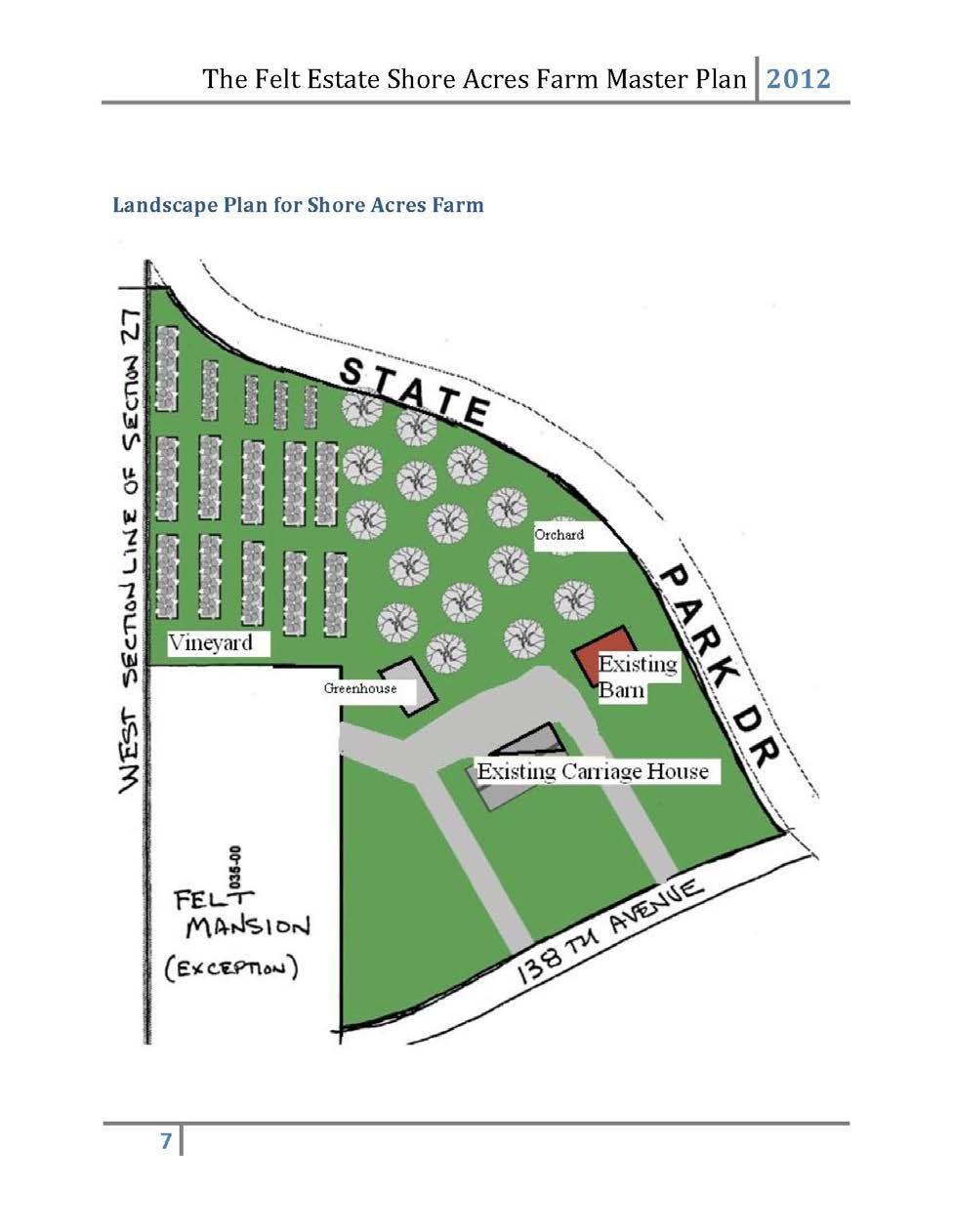
23 This park is compliant on the lower level trail system. Parking areas are paved with handicapped spaces clearly marked. The trail system is made from wooden bridges and a material that is called chips and fines which packs down to a hard surface that is wheelchair accessible. The bridge in the park is made with wood decking and has a gentle pitch. There is a large stairway in the park that is not barrier free which leads to a hill top trail system. A barrier free exemption on this project was requested of the federal government and granted. Shore Acres, th Ave. This 39 acre park borders and connects to Saugatuck Dunes State Park and the Felt Mansion, a National Register Historic Site. Features include a two-mile mountain bike trail, 18 - hole disc golf course, large parking lot, free beach access, and porta-potty. Horses and dogs on leashes are allowed. This property saw tremendous growth in recreational activities. An 80-man prison structure, which was located on the property when Laketown received the parcel from the State of Michigan in 1993, was crushed and used for road material. This crushed concrete was used to improve park driveways and access at several locations, with the most notable improvement to Huyser Farm Park. In 2011, a historic church building, formerly Gibson Church, was moved to this property to support activities at the Felt Mansion, which is adjacent to the property. Improvements to the parking lot doubled the parking capacity. Previously, the site was home to a dirt bicycle track, winter ice-rink, and summer concerts. A community solar garden was added in December, Barrier free compliance. This park is heavily used in conjunction with Felt Mansion activities, which is immediately adjacent. The parking area is gravel and lacks handicapped marked spaces although paved and marked spaces are available at the Mansion. Hiking trails connect to a larger state park system maintained by the State of Michigan. A disc golf course is actively used and golf tees are concrete and pathways are mowed regularly. The area is largely vegetated soils that are possibly handicapped accessible. The church is barrier free and the building is available for planned events. 23


24 Township Hall Recreation Complex, 4338 Beeline Rd. This 6.4 acre park features a softball diamond, soccer field, picnic gazebo, and meeting place for classes and indoor activities. Restrooms and drinking fountains are available during business hours in the Township Hall building. Outside portable restroom also available. In accordance with the development plan created by M.C. Smith and Associates for the 2007 recreation plan (see Appendix item K), this property was cleared of scrub brush and site work completed for future recreation facilities. In 2010, the commission collaborated with the City of Holland and the Army Corps of Engineers in the relocation 25,000 cubic yards of clean, tested, dredged soil to this park which needed to be relocated at the request of the Army Corps of Engineers. Grants through the Michigan Natural Resources Trust Fund and Land and Water Conservation fund of MDNR were approved late 2011, with construction from with the installation of a softball field, soccer field, and picnic shelter. Underground sprinkling, a porta-potty, and paved walkways were additionally added to the site in


25 Grants received include the following: 2012 Recreation development, DNR/Trust Fund. Barrier Free Compliance This park is barrier free compliant. Parking areas are paved with marked handicapped spaces. Walkways are concrete. Wolters Woods, th Ave. This 36+ acre park features a large picnic pavilion, playground, hiking/cross country ski trails, pit toilets, and parking, completed in 1995 of Phase I. Two horse shoe pits and two shuffleboard courts were added in Additionally, a grant was approved and completed in 2012 from the Michigan Natural Resources Trust Fund for land acquisition to add an adjacent 2-1/2 acre parcel with road frontage to the existing 34 acre site which provides a wildlife corridor for deer, turkeys, and other animals. It also placed additional footage of the Ottagan Intercounty Drain system within the park for the enjoyment of residents and allows the Township greater ability to manage the Drain, as significant flooding has occurred in previous years. 25

26 Grants received for this park include the following: 1992 Acquisition, DNR/CZM; 1993 Development, DNR/Rec Bond; Land addition, DNR/Trust Brownfield. Barrier free compliance. The park is barrier free compliant. Parking areas are paved with marked handicapped spaces. The trail system is made from wooden bridges and a material that is called chips and fines. This material packs down to a hard surface that is wheelchair accessible. The restroom at the park is equipped with handrails. COMMERCIAL RECREATIONAL OPPORTUNITIES IN THE TOWNSHIP Equestrian Bay Meadows Arabian, th Ave Centennial Acres Equestrian Ctr st St. Fell in Love Farm th Ave Fieldstone Farm rd Ave Great Lakes Equestrian Ctr., th Ave Holland Western Saddle Club, st St. Laketown Farms, st St. Pine Manor Arabian, 6238 Woodcliff Dr. Teusink s Pony Farm, 1468 W 32 nd St. Windy Ridge Board Farm, th Ave. centennialacresdressasge.com fellinlovefarm.com fieldstonefarm.net greatlakesequ.com hollandwestern.net laketownfarms.com pinemanorarabians.com teusinksponyfarm.com Golf Courses and Facilities Laketown Golf & Conference Ctr., 6069 Blue Star Practice tees and putting greens. Theater Red Barn Playhouse, rd St Community Theater 26
27 COMMERCIAL RECREATIONAL OPPORTUNITIES WITHIN FIVE MILES Cruise & Fishing Charters Bachelor One Fishing Charter Beau H20 Excursions Holland Princess (cruises) Holland Sport Fishing Deep V Sport Fishing Charters Deeplake Ventures Sailing Charters First Class Excursions Fish N Fin Charter Service Nancy Anne Fishing Charters Sailing Mac Charters Saugatuck Boat Cruises bacheloronefishing.com Park Twp beau2oexcursions.com hollandprincess.com Holland Twp hollandsportfishing.com Park Twp deepvsportfishing.com Park Twp deeplakeventures.com Park Twp fcexcursions.com fishnfin.com Park Twp nancyannesasilingcharters.com sailingmaccharters.com Park Twp saugatuckboatcruises.com Saugatuck Entertainment BAM Bowling/Laser Tag/Arcade gobamgo.com Captain Sundae Mini Golf captainsundae.net Craig s Cruisers Indoor game room, go-karts, mini golf, batting cage Home Roller Rink Lot City laser tag, mini golf, arcade the-lostcity.com Holland Twp M-40 Paintball m-40 paintball.com Holland Northland Lanes (bowling) northlandlanes.com Holland Twp Therinkholland.com Holland Twp. Saugatuck Dune rides Scenic ride through sand dunes Sundae Sundae Golf Golf Holland.org/listings/Sundae-Sundae-Golf-Golf/542/ Equestrian Rusty Spurs Ranch Golf Clearbrook Golf Course The Links at Rolling Meadows Ravines Golf Course West Shore Golf Course Horseback riding and Renew Therapeutic Riding 18 holes linksapr3.com 18 holes 18 holes Launch Ramps Kollen Park Launch Ramp (City) Dunton Park Launch Ramp (Holland Charter Township) South Shore Launch Ramp (Park Township) DNR Launch Ramp (DNR) Marinas Anchorage Marina & Yacht Club Barney s Marina Bay Haven Marina Eldean s Shipyard Marina 27
28 Yacht Basin Marina PUBLIC/NONPROFIT RECREATIONAL OPPORTUNITIES WITHIN FIVE MILES Douglas Beery Field Boat Launch Boat Launch Public Beach Riverview Park Public Library Schultz Park Fennville New Richmond Park Holland Outdoor Discovery Ctr. Cappon House Museum Centennial Park Tennis DeGraaf Nature Ctr. Evergreen Commons Sr. Ctr. Herrick District Library Holland Area Arts Council Holland Comm. Aquatic Ctr. Holland Heights Park Holland Museum Hope College Kollen Park Lake View Park Lincoln Park Macatawa Marsh Maplewood Complex Matt Urban Park Moran Park Prospect Park Smallenberg Park VanBragt Park Van Raalte Farm Windmill Island Window on the waterfront Dunton Park Restrooms, bleachers, diamond, tennis courts, winter ice-skating. Kalamazoo River access, Center Street. Kalamazoo River access, Union Street (fee charged). Lake Michigan access with parking, restrooms. Open space, picnicking. Kalamazoo River access with picnic shelter, baseball diamond, soccer field, pit toilets, boat launch, fishing, and nature trail. Fishing, kayaking, boardwalk trail, historic train crossing. Operated by Wildlife Unlimited with trails, captive animals, interpretive displays. Historic building and museum. Community park. Columbia Avenue Courts Trails, boardwalk, and nature center. Art, dance, music classes. Leisure & competition pool, lap swim (fee charged) Basketball, picnic facilities, playground. Art gallery, theater, music and dance productions. Band shell, picnic areas, playground, boat launch, and Heinz walkway along Lake Macatawa. Picnic facilities, playground. Skate park, playground. Open Space. Playground. Sports Complex, Playground, 3 softball diamonds, concession stand, restrooms Tennis, Playground Playground, trails. Playground, outdoor pool, ice-skating. Picnic tables, Lake Macatawa access. Hiking/skiing trails, sledding. Tourism, Black River access. Boardwalk, marsh viewing, Lake Macatawa Kayak launch Lake Macatawa boat launch, boardwalk, fishing dock, shelter, playground. 28
29 Holland Township Zuidema Farm Holland Twp. Trails. Bike Paths Paved bike paths which run along 32 nd St. and South Shore Drive connecting to Park Township and City of Holland Boat launch Lake Macatawa access. Park Township Virginia Park, Maatman Ctr. Residential park with softball field, playground, four tennis courts, two basketball courts, picnic tables. Saugatuck Cook Park Overlooks Kalamazoo Lake, green space Mt. Baldhead Park Dune/forest park, restrooms, picnic tables, shelter, river dock, museum, trails and stairs to observation deck overlooking harbor. Oval Beach Lake Michigan beach access with parking, restrooms, showers, picnic tables, barbecue grills, concessions, swimming. Boat Launch Saugatuck Village Square Basketball and tennis court, playground and restrooms. Wick s Park Kalamazoo River views, bandstand, restrooms Willow Park Observation deck with 132 ft of frontage on the Kalamazoo River Saugatuck Township Amalanchier Park Blue Star Roadside Park Hacklanders Public Access Non Motorized Trail River Bluff Park Sundown Park Tails N Trails Dog Park Four acres wooded site with trail to Moore s Creek. Two picnic tables and shelter. Kalamazoo River boat launch site operated by the MI-DNR with parking, picnic tables, and restrooms. 1.7 miles of from 64 th St. at Laketown Twp to the Saugatuck City limits. Kalamazoo River frontage. Picnic area, playground, hiking. Bluff overlooking Lake Michigan. A 5-acre dog enclosure with walking paths, seating. 29
30 PUBLIC/PRIVATE SCHOOLS Schools located within the township: Calvary School Soccer fields, basketball courts School Districts within the township: Hamilton Schools Blue Star Elementary Playground, sledding hill, track. Holland Schools Black River Eagle Crest Charter Holland West (K-7) Basketball hoops, four tennis courts, soccer field, softball field. Holland High Vanderbilt Holland Christian Schools Pine Ridge Elementary Playground, basketball courts, open area. Holland Christian Middle Basketball hoops, baseball diamond, soccer field. Holland Christian High Football and soccer field, eight tennis courts. Saugatuck Schools Saugatuck High Tennis courts, football field. PROGRAMMING OUTREACH The Commission has collaborated with a number of local groups and agencies to provide activities and public use of park facilities. Participants include: Black River Public Schools, Boy Scouts of America, the City of Holland, DeGraaf Nature Center, Friends of the Felt Estate, Holland Christian High School Senior Serve Day, Outdoor Discovery Center / Macatawa Greenway, Michigan State University Extension Office, Shore Acres Disc Golf Club, the United Way Day of Caring, West Michigan Land Conservancy, and West Michigan Mountain Bike Association. Adopt-A-Park Program This is a program in which a volunteer group may select a park for community service hours. A list of specific grounds and maintenance needs is available for each park, as well as a wish list of desired improvements. See Appendix (M) Park Exploration Days with the Outdoor Discovery Center (ODC) In collaboration with the Outdoor Discovery Center, the commission has annually sponsored park exploration days either free or a small charge for attendees throughout the year. See Appendix (L) Parks Reservation Use Application A Use and Reservation Application was developed in This application provides guidelines for groups of 20 or more to organize and host events, and alleviates conflicts of use as well as ensures a safe and clean environment. Currently no fees are charged for use of the parks and the application must be completed and approved in advance. See Appendix (O) 30
31 Wildlife and Vegetation Inventories and Brochures A brochure highlighting the township parks is available free of at the Township Hall. LONG TERM GOALS Establishing long-term goals provides a direction for the Township to proceed. Goals should be thought of as ideals for which to strive. 1) Provide and maintain a park, trail, and open space system including access to Lake Michigan that is responsive to the needs and priorities of the township residents. 2) Provide residents an opportunity to pursue recreational activities on a year-round basis. 3) Acquire and otherwise protect open space in developing areas to maintain the rural character of the township and assure adequate recreational opportunities in the future. 4) Work with other Laketown Township commissions to encourage developers of raw land to provide park sites, trails, or open spaces as an integral part of the development planning. 5) Use careful observations and measurements of park use patterns as the basis for change in existing park lands. 6) Collaborate with neighboring communities and organizations to establish and expand a network of greenways as corridors for wildlife and trails for hiking, biking, cross-country skiing and other recreational activities. 7) Encourage and assist private land owners in developing preservation strategies for their properties. 8) Develop access to recreational facilities for residents with limited physical abilities. 9) Maintain a plan for the identification and protection of historical sites within the Township. 10) Work with neighboring townships, counties, agencies, and Michigan State University and other ecological specialists developing appropriate non-obtrusive ways to control invasive plant and insect species and encourage native species to thrive. 31
32 ACTION PROGRAM Below is a listing of projects that are desired. Projects are subject to change due to available funding and/or resident needs. Farview Park Project areas: parking area, boardwalks, and fishing dock. Funding sources: the general fund. Historic Town Hall Project: relocation of the building to another park with greater activity. Renovation as a restroom or classroom is desired. Funding sources: a combination of local and grant funds. Huyser Farm Project areas: Restoration of the historic farm house, creation of trails, fishing dock. Restoration of orchards. Funding sources: a combination of local and grant funds. Laketown Beach Project areas: obtaining title to a small in-holding parcel of land that would improve access, acquisition of additional parking access, more vegetation planting, construction of restroom facilities, improvement or replacement of the aging stairway system. Acquire additional land as it becomes available. Funding sources: local and grant funds. Land Acquisition Project areas: the acquisition of additional property suitable for development of active and passive recreation including a dog park, conservation and public access to Lake Michigan and inland waterfront is desired. Funding sources: the general fund, donor funds, and grant funds. Non-motorized Paths Continued expansion of non-motorized opportunities throughout the township using a combination of shared use paths and bike lanes. Funding sources: a combination of general funds and grant funds. Park Master Planning and Development The Commission actively seeks help for the development of recreational facilities by applying for grant funds from a variety of sources such as Allegan County, the Michigan Natural Resources Trust Fund, Michigan Department of Transportation (MDOT), CMZ, and the Land and Water Conservation fund through the Michigan Department of Natural Resources (MDNR) along with private foundations and sources. Sanctuary Woods Project areas: Phase III development including restoration of the historic Interurban Bridge, interpretive signs, trail signs, improved erosion control and restrooms. Funding sources: general funds and grants. Shore Acres Park Project areas: drinking fountains and restroom facilities. Funding sources: general fund and grants. Shore Acres Farm Project areas: restoration of the carriage house, barn, and pump house in keeping with the Secretary of Interior s Standards for the Rehabilitation of Historic Structures for Adaptive Use, with an objective to keep the buildings as original as possible while still allowing for public use. Restore limited farming activities. Funding source: general funds, donations and grants. Township Hall Recreation Area Project areas: Pickleball court, walking trails. Funding source: general fund and grants. 32
33 Wolters Woods Project areas: Acquiring additional land for development of a dog park. Funding source: general fund and grants. CAPITAL IMPROVEMENT PROGRAM Projects are listed in general order of priority. PERIOD PROJECT COST FUNDING SOURCE Township Beach Development Land acquisition Township Beach Picnic Area with restrooms/bathhouse Sanctuary Woods Restroom Township Hall Rec. Complex Restrooms Pickleball Court Wolters Woods Development Land acquisition for dog park Develop Dog Park Acquire inholding New restroom 1,000, ,000 Local 750,000 Trust Fund 60,000 15,000 Local 45,000 Passport 150,000 50,000 Local 100,000 Trust Fund 1,000, ,000 Local 750,000 Trust Fund Non-motorized Trail Development Design & construct Blue Star Trail Design & construct 145 th Ave Trail Way Finding Signage Huyser Farm Development 1,000, ,000Local 750,000 MDOT Shore Acres Restroom 75,000 25,000 Local 50,000 Passport Sanctuary Woods Development Land Acquisition Restore Train Trestle Restroom Farview Park Devlopment Restroom Trail Improvements 1,250, ,000 Local 1,000,000 Trust Fund 75,000 25,000 Local 50,000 Trust Fund 33
34 LIST OF APPENDICES Notice of Public Hearing - A Laketown Township Street Index Map - B Laketown Township 2006 Existing Land Use Map - C Laketown Township 2006 Future Land Use Map - D Laketown Township 2006 Natural Features Map - E Downtown Development Area Map F Parks Commission 2006 Residents Survey - G Laketown Township Map of Parks and Pathways- H Laketown Township Non-motorized Path Plan - I Huyser Farm Concept Plan - J Recreation Complex Concept Plan K Park Exploration Days with the ODC - L Adopt-A-Park Application M Parks Reservation Use Application - N The 2012 Felt Estate Shore Acres Farm Master Plan O 34

35 Appendix A Notice of Public Hearing 35

36 Appendix B Laketown Township Street Index Map 36

37 Appendix C Laketown Township 2006 Existing Land Use Map 37

38 Appendix D Laketown Township 2006 Future Land Use Map 38

39 Appendix E Laketown Township 2006 Natural Features Map 39
40 Appendix F Laketown Township Downtown Development Area Zoning Map 40
41 Appendix G Needs Assessment Survey 2016 LAKETOWN PARKS AND RECREATION NEEDS ASSESSMENT SURVEY RESULTS 84 Respondents (2723 pool) 10/19/16 1) Please place a in the boxes below representing the number of times you or a member of your family visited a park in the past year. If you have not visited a park, please tell us why. YEARLY ATTENDANCE 0 visits 1-5 visits 6-10 visits 11+ visits L A K E T O W N B E A C H S A N C T U A R Y W O O D S S H O R E A C R E S W O L T E R S W O O D S H U Y S E R F A R M F A R V I E W P A R K T W P R E C C O M P L E X H I S T O R I C T O W N H A L L Didn t know they were there (4) Downtown Holland park where we can visit/see town is better. Presence of ticks and stable flies carrying Lyme Disease, Babesiosis, Bartonella. We have a family reunion once a year. We re not athletic, think there is enough parks for a long time. The parks we haven t visited we didn t know about Live in wooded area as is and don t need to go to a park. Would love easier way to get to Lake MI though. We have only lived in the area since We are looking forward to exploring the other parks. Didn t know about historic town hall Gilligan, Goshorn, Kelly Lakes was not aware of access! Plan to visit this park this year (Township Hall Recreation Complex) What about Felt Mansion. What is the name of the park? I plan to check them out this year Don t have time. Have never visited the parks since we lived here over 40 years. We need less parks & expenses in Laketown Township! Period!!! Historic Park has dogs around it (or at least I see them walking to park) They are not very interesting and frankly I feel they are a drain on Laketown township residents. We would be better served if they were sold and the profits used to pay down our debts. 85 years old I was not sure on the location, nor that it was there/available Not near my house. Other parks are nearer. Laketown Beach too many steps up & then down to the beach. I would visit Wolter s Woods much, much more if dogs on leashes were permitted! We don t really know about it or haven t investigated what the park offers Repair & maintain existing features many repairs of existing needed keep parks simple & rural setting 41
42 Farview too wet, too close to interstate. Township Hall complex no interest in softball Historic Town Hall no support for restrooms here! 1 2) Please place a in the box representing an improvement you would like to see, and any suggestions you may have. Improvements Beach Access Drinking Fountain 12 6 Fenced Dog Park Improved Parking Out door Ampitheater Paved Trails Pavilion/Shelter Picnic Area Restrooms Beach Access (25) Stairs cleaned Steps of Laketown Beach, can t do stairs or hills Word is out on Laketown. Bummer it used to be quiet! Need more for public use Tunnel to Beach (Laketown) (2) Dogs end discrimination Unsure Would like more beach access sites More Parking Laketown More beach access and easier paths for those with disabilities Shorter stairway over lower dune. Fundraiser. Rebuild Laketown Beach Stairs I wish we had more beach access!!! Roll up matts like Elberta Beach Laketown No need Fenced Dog Park (22) Agreement to share at Lakeview school, nice We love Tails & Trails beach park too? Corner of 32 nd & 61 st Wolters Woods Need to keep dogs off private & public beaches they crap everywhere and the owners often don t clean up. Yes! Improved Parking (14) Laketown Beach (5) For concerts at Shore Acres Dust control Fairview (3) Restrooms (13) Add to all parks were not available Shore Acres (2) Township hall, bath house for Laketown beach Little dogs separate from big dogs. Laketown Township Hall (4) Near northern side of township e.g. near city. Country dwellers can let dogs run on their own prop. But we city people need a place! No need Laketown beach is crowded w/limited parking Big lot at Felt Mansion has pot holes No need Flush toilets Laketown beach (3) cleaned No need 42
43 Sledding Hill (12) Shore Acres Yes Great Idea Good at Felt Mansion Paved Trails (11) 146 th (at least btwn 61 st & 62nd) For Biking Bike paths/nature trails for strollers/bikes Pavilion Shelter (8) Lakeview athletic field if agreement is made Add to all parks, where not available Update the shelter at Shore Acres Shore Acres Drinking Fountain (6) Fairview(2) Shore Acres (2) Sanctuary Woods Picnic Areas (5) Add to all parks were not available Fairview & Wolters Woods Anywhere Make a large sledding hill for snowboarding/sleds. Fairview & Sanctuary Woods No need Fairview & Wolters Woods Sanctuary Woods No need Wolter Woods No need No need 2 Outdoor Amphitheater (4) Shore Acres No need Other (23) Remove/cutting back the shrub taking over Halce/Gilligan Lake. I would volunteer for this project. (name omitted). One page map of parks in one newsletter per year. More pruning & clearing the blueberries at Huyser send out announcement -for when you are doing this others will come help prune & weed. You are not a draw we are so close to Holland & Saugatuck Penalties for dog owners who walk their dogs off leash. Add exercise stop points to one of the park trails. Benchmark Portland MI as example. ORV trails to Laketown Beach but know people would abuse!! Pipedream even tho there are signs No Dogs we see lots of dogs on beach at Shore Acres please enforce better No! We have enough parks! I do not want taxes to go to luxury items for other people to use. When I drive by these parks, all but 2 never have anybody there. Only felt & Laketown beach do, and many there are not Laketown residents. Make them fee entry. We pay for these items for non-residents to use for free. I should be able to use Herrick Library free then. Deer tick control, deer population control. The deer are eating all our natural plant vegetation Invasive vegetation control My recommendation is: The parks are beautiful. Keep them as natural as possible. Hire person(s) to pick up trash & debris left by some Dogs. Slow down developments. Soon to be: subdivision township. Overthrow (name omitted) & his land-grab. (Omitted) needs more signs on every street of the township. Remember to stay off (omitted) land. Private property (orange). The (omitted) owns this township! And does not like peasants on his land! We d love to see a playground at the Township Hall Recreation complex swings, jungle gym, etc. Also, a soccer field with marked boundaries, goals at the township hall would allow teams to utilize the green space more. Improve pond at Fairview by adding a set of picnic tables & pavilions also make the trail to pond more user friendly. Fish stocked in Farview pond with fishing docks & access around the entire pond. Biking trails back to pond for kids who what to fish and for O.Discovery Center programs. No new taxes (omitted) and the assessor are paid too much. Please patrol Wolter s Woods more often. Lots of drug deals going down in parking area and on walking trail. Woods smell of Marijuana often. I really enjoy the mountain bike trail at shore acres. I also like seeing so many folks playing Frisbee golf. More signs stating No dogs on Beach! Groomed trails hiking/x-country skiing@ Saugatuck State Park 43
44 In cooperation with State DNR it would be nice to install a footbridge/path into the corner of the Saug. Dunes State Park from the corner of 66 th /140 th for walkers. Narrow entry/turnstyle to prevent ATV s, bikes. Marked walking trails at Huyser Farm. 3 3) If you, an organization, or a company that you belong to is interested in volunteering or providing financial support to a park or recreational activity, please provide your contact information: Spend your & our money on the above picking up trash as it appears. Suggest to township residents that they could put $ in a will or donate to parks now for improvements. Leave a Legacy If there s any way you need help with fundraising efforts or light duty maintenance. I often pick up litter along 65 th & 66 th & 140 th! (name omitted) 4) Place a in the box representing an activity in which you or a family member participated in the past year. Tow Tow RECREATION LOCATION RECREATION LO 94 Beach access Laketown Beach Picnic areas var par Shore Acres Sho (33) 16 Disc golf course Acr 77 Dogs on Leashes Sanctuary Woods (26) 16 Nature Programs w/odc var par Shore Acres Cross Country var (21) 13 Skiing par Huyser Farm (16) 12 Snowshoeing var par Mountain Bike Sho Fairview (14) 8 Trail Acr 62 Walking Various Parks 6 Softball Field Ha 52 Bike Paths Various Streets 5 Geo Caching var par 41 Fishing Goshorn Lake (15) 4 Horseback Riding Fai Gilligan Lake Bow hunting Hu (14) 4 (permit only) Far Kelly Lake Tow (12) 2 Soccer Field Ha 28 Blueberry picking Huyser Farm 2 Basketball courts Ha 27 Canoeing/kayaking Goshorn Lake (12) Other: I did almost all these activities elsewhere! Birdwatching: playground at Wolters Woods Kelly Lake (9) Gilligan Lake (6) Other: See comments below 44
45 None of the above Walters Woods walking dog on leash (Snowshoeing) not this year, but two winters prior. No 5) Are there any additional recreational activities you would like to see offered? Tennis at Lakeview Don t use them, don t want to pay for them. Library too! Hunting access Will be in for parks map! Need to explore more! A park area for dogs off leashes. Tennis, hiking paths, tick safe Playground Cherrywood subdivision More safety when riding horses we have ridden in Laketown for over 40 years & the new people moving into the area dive like lunatics around horses. We will start riding in the center of the road to put traffic to a stop if they don t start respecting riders! This is for our safety while riding! Dog park Put the monies toward updated the Gibson Cemetary More beach access sites Sledding We have enough free park access paid for by Laketown tax payers, people with lakefront or lake access pay ridiculous taxes, most without natural gas, internet, garbage, city water, proper cell service, snow plowing, and on & on & on More ODCMG programs especially kayaking or water related. Dog Park, More beach access! No Allow dogs on leash at Saug. Dunes beach? I know this is a state park, but we could ask the state to waive the restriction. After hiking that trail my dog needs a drink! Please see attached letter (restrooms at Shore Acres and Laketown beach ), Canoe/kayak launch from BPW property, Purchase private dune property for a park ). 4 6) The township does not currently charge a millage for funding, maintenance, and improvements to parks and recreation. Please place a indicating the following areas you would support if available: Funding Options Donation Millage Grants Fees for Endowment park use Fund reservation Fees for free activities Special Interest Group Matching Funds Other Other: Volunteer Hours Should already be covered by our taxes 45
46 Is Shore Acres a state park or part of Felt Mansion. Who is paying for that semi-private luxury. We don t need more taxes! 46

47 Appendix H Laketown Township Map of Parks and Pathways 47

48 Appendix I Laketown Township Non-Motorized Path Plan 48

49 Appendix J Huyser Farm Concept Plan 49

50 Appendix K Recreation Complex Concept Plan 50
51 Appendix L Park Exploration Days with the ODC Conducted by staff of the Outdoor Discovery Center Macatawa Greenway Please contact the ODCMG office to register: or odc@outdoordiscovery.org Superb Owl Prowl (Sanctuary Woods) Friday, February 3 5:00-6:30 pm Hike the dune of Laketown Township's Sanctuary Woods in search of resident and migratory owls. The group will try to call in Eastern Screech, Barred and Great Horned Owls as they hike. Flashlights are welcome. Registration required Fee: FREE Adult Nature Hike (Far View Park) Saturday, February am to 12 pm Led by a naturalist from the Outdoor Discovery Center, the group will explore the plants, animals and other features of the Huyser Farm on this casual hike. Wear comfortable walking shoes/boots and be prepared to walk on the trails of the 102 acre property. Registration required. Fee: None Searching for Snow fleas (Huyser Farm) Saturday, March am to 12 pm These are not the kinds of fleas that bite! Springtails, also known as snow fleas, are an important part of a woodland ecosystem and they are harmless. Get a chance to find these tiny arthropods and take a closer look at them using magnifiers and microscopes. Dress for the weather since much of the program will be outside. Registration required Fee: $4 per person, FREE to Members Knee-deep in a Wetland (Farview Park) Friday, April 21-7:30-9 pm Meet a naturalist at Far View Park in search of amphibians, insects and other aquatic life. All collection tubs and dip nets will be provided. Old shoes or boots that can go into the water are recommended. No sandals or bare feet allowed. Children under 8 years old must be accompanied by an adult. Registration required. Fee: None Spring Wildflowers of Sanctuary Woods (Sanctuary Woods) Saturday, May 6 6:30-8:00 pm Hike the natural trails and stairs of Sanctuary Woods with a naturalist as you find and identify woodland wildflowers. Cameras are encouraged. Sturdy hiking shoes are required. Field guides and magnifying glasses will be provided. Registration required. Fee: None Little Explorers (Wolters Woods) Saturday, June 3 10:00-11:30 am Explore the nature trail as only a preschooler could do. Find colors, shapes, and textures on the easily accessible trails of Wolters Woods. All materials will be provided. At the conclusion of the program, feel free to make time to play on the playground. Registration required. Fee: None Wetland Discovery (Farview Park) Thursday, June am Explore the wetland for critters like frogs, toads and insects. The edge of the wetland is easy for even the littlest explorer to access. All materials will be provided including nets and collection tubs. Boots or shoes that can go into the water are encouraged. No bare feet. All ages welcome. Registration required. Fee: None Hike by the Light of the Moon (Huyser Farm) Friday, June 9 8:30-10 pm Explore the trails of Huyser Farm in search of birds, amphibians, mammals and insects on a nearly-full moon night. Field guides and other investigation materials will be provided. The trails may be muddy or buggy, so please come prepare for the conditions. Registration required. Fee: None Blueberry Fields Forever (Huyser Farm) Thursday, July am - 12 pm Learn about blueberries and how they have become a West Michigan industry. Bring collection buckets to take home some free blueberries from the u-pick, organic blueberry patch! Sturdy shoes and insect repellent are encouraged. Registration required. Fee: None Hawk Watch (Farview Park) Saturday, September 30 10:00 am - 12:00 pm Hike to the top of the steps leading to the beach to watch for migrating raptors. Though songbirds may be spotted along the way, the focus of this program is bird of prey migration. Once at the top of the boardwalk steps, the group will be stationary as they watch for migrants riding the thermal air currents along the dune ridge. Some loaner binoculars will be available for lending. Registration required. Fee: None Adult Nature Hike (Huyser Farm) Saturday, October 6 6:30 pm to 7:30 pm The fall colors should be near their peak for this hike led by a naturalist from the Outdoor Discovery Center. In addition to noting the fall foliage, the group will explore the plants, animals and other features of the Huyser Farm on this casual hike. Wear comfortable walking shoes/boots and be prepared to walk on the trails of the 102 acre property. Registration required. Fee: None 51
52 Appendix M Adopt-A-Park Program Appendix N Parks Reservation Use Application 52
53 53
54 54

55 Appendix O The 2012 Felt Estate Shore Acres Farm Master Plan 55
56 56
57 57
58 58
59 59
60 60
61 61
62 62
Acquisition in fee simple of approximately one-half acre of property on the shore of Spring Lake to expand the Lakeside Beach Park.
 Lakeside Beach TF00-136 $122,550.00 in fee simple of approximately one-half acre of property on the shore of Spring Lake to exp the Lakeside Beach. 2000 River Ravines TF00-150 $910,000.00 in fee simple
2. Goals and Policies. The following are the adopted Parks and Trails Goals for Stillwater Township:
 D. PARKS AND TRAILS 1. Introduction Stillwater Township s population is relatively low, with most residents living on rural residences on large lots. The need for active park space has been minimal in
NORTHWEST SECTION CONTENTS: CLEVELAND PARK FOLWELL PARK RYAN LAKE PARK VICTORY PRAIRIE DOG PARK VICTORY PARK
 NORTHWEST SECTION CONTENTS: CLEVELAND PARK FOLWELL PARK RYAN LAKE PARK VICTORY PRAIRIE DOG PARK VICTORY PARK LUCY LANEY COMMUNITY SCHOOL N 33RD AVE N 33RD AVE SINGLE-FAMILY RESIDENTIAL MULTI-USE DIAMOND
Chapter eight. Parks and Recreation. Introduction. Crystal Lake Park District
 Chapter eight Parks and Recreation Introduction One of the indicators of quality of life in a city is the parks and recreation system. The City of Crystal Lake is fortunate to have an excellent parks and
Blueways: Rivers, lakes, or streams with public access for recreation that includes fishing, nature observation, and opportunities for boating.
 Parks, Open Space and Trails PRINCE WILLIAM COUNTY 2008 COMPREHENSIVE PLAN TRAILS PLAN CONTENTS The components of the trails plan are: Intent Definitions Goals, Policies, and Action Strategies Trails Map
Lake Myra County Park. Wake County, North Carolina Community Forum #2 June 12, 2008
 Lake Myra County Park Wake County, North Carolina Community Forum #2 June 12, 2008 Welcome and Introduction Meeting Agenda Welcome Introductions of Project Team Master Plan Process Community Forum #1 Updates
Schoolcraft Township is located in northeast Houghton County. A portion of the township borders Keweenaw County and Lake Superior.
 COMMUNITY DESCRIPTION Schoolcraft Township is located in northeast Houghton County. A portion of the township borders Keweenaw County and Lake Superior. The township is largely rural but has one main population
City of Haslett. City of East Lansing. City of East Lansing
 Central Park North (Nancy L. Moore Park) Lake Park North Expansion White Park Expansion #2 White Park Expansion #1 County East East Haslett East East TF87-212 Acquisition $90,000.00 Park. TF08-138 Acquisition
MASTER PLAN EXECUTIVE SUMMARY
 Biscuit Run State Park Scottsville Road (State Route 20) Charlottesville, VA 22902 Biscuit Run State Park MASTER PLAN EXECUTIVE SUMMARY Department of Conservation and Recreation Division of Planning and
Chapter 2: Summary of Existing Open Space System
 Chapter 2: Summary of Existing Open Space System In 1976, the Wake County Board of Commissioners established the Wake County Parks and Recreation Department in order to provide park facilities and programs
Hazlet. 1. Overview of Hazlet and Its Waterfront. Hazlet Township. 1.1 Geographic Overview
 Hazlet 1. Overview of Hazlet and Its Waterfront 1.1 Geographic Overview Hazlet Township is located in Monmouth County. The Township has a land area of 5.6 square miles. Situated in the Bayshore region
Northeast Quadrant Distinctive Features
 NORTHEAST QUADRANT Northeast Quadrant Distinctive Features LAND USE The Northeast Quadrant includes all the area within the planning area that is east of Interstate 5 and to the north of State Route 44.
NORTH OF BROADWAY SECTION CONTENTS: COTTAGE PARK FARVIEW PARK GLEN GALE PARK IRVING TRIANGLE JORDAN PARK NEWTON PARK PERKINS HILL PARK
 NORTH OF BROADWAY SECTION CONTENTS: COTTAGE PARK FARVIEW PARK GLEN GALE PARK IRVING TRIANGLE JORDAN PARK NEWTON PARK PERKINS HILL PARK N ILIO NA VE N JAM ES AV E PLAYGROUND PAR K PRO PER TY B OUN DAR Y
THOMAS A. SWIFT METROPARK Introductions History Present Conditions Future Development Plans Implementation Strategies Statistics
 THOMAS A. SWIFT METROPARK Introductions History Present Conditions Future Development Plans Implementation Strategies Statistics Introduction As an open meadow park positioned along the Mahoning River,
Flow Stand Up Paddle Board Parkway Plan Analysis
 Regional Parks Department Jeffrey R. Leatherman, Director County of Sacramento Divisions Administration Golf Leisure Services Maintenance Rangers Therapeutic Recreation Services Flow Stand Up Paddle Board
PROPOSED MINUTES LAKETOWN TOWNSHIP PARKS & RECREATION COMMISSION AT TOWNSHIP HALL. October 20, 2010
 PROPOSED MINUTES LAKETOWN TOWNSHIP PARKS & RECREATION COMMISSION AT TOWNSHIP HALL October 20, 2010 ARTICLE I. CALL TO ORDER Chairperson Linda Howell called the regular Parks & Recreation Commission meeting
Yuba Creek Natural Area Acquisition. Acme Township. Acme Township. TF Acquisition $1,576, Grand Traverse
 Yuba Creek Natural Area TF00-162 $1,576,021.00 in fee simple of 403 acres of critical wetls upl habitat with over 5,000 feet of frontage on Yuba Creek, a tributary to the east arm of Bay. 2000 Petobago
1. Overview of Atlantic Highlands and Its Waterfront
 Atlantic Highlands 1. Overview of Atlantic Highlands and Its Waterfront Atlantic Highlands: Satellite Photo by USGS 1.1. Geographical Overview The Borough of Atlantic Highlands is on Sandy Hook Bay. It
Silver Lake Park An Environmental Jewel for the Citizens of Prince William County
 Silver Lake Park An Environmental Jewel for the Citizens of Prince William County The Prince William Park Authority Mission Statement states: The Prince William County Park Authority will create quality
J. Recreation Plan of Conservation and Development. The Town of Hebron. Section 2. Preservation of Unique Assets. 1 P a g e
 The Town of Hebron Section 2 2014 Plan of Conservation and Development Preservation of Unique Assets J. Recreation Open spaces, parks, sports fields, and recreational programs are considered essential
Stambaugh Township 5-Year Recreation Plan - DRAFT
 Stambaugh Township 5-Year Recreation Plan - DRAFT Stambaugh Township GEI Project No. 1702677 January 5, 2018 Table of Contents 1. Community Description 1 2. Administrative Structure 2 3. Recreation Inventory
Pinellas County Environmental Lands
 Pinellas County Environmental Lands In addition to traditional parks and recreation facilities, Pinellas County owns and manages a system of environmental lands that provides specialized resource-based
Camping (Primitive) Camping (RV) Electrical Potable Water Grill Established Fire Pit Picnic Table
 Camping (RV) Electrical Potable Water Grill Established Fire Pit Picnic Table") Alden - 9th Road River Mile 777 Map: 38.20833, -98.32031 Managing Agency: Kansas Department of Wildlife, Parks & Tourism Nearest Community: Alden, Rice County Kansas Developed Amenities Provided Parking
Alden - 9th Road River Mile 777 Map: 38.20833, -98.32031 Managing Agency: Kansas Department of Wildlife, Parks & Tourism Nearest Community: Alden, Rice County Kansas Developed Amenities Provided Parking
Rogue River Access and Management Plan Draft Alternatives
 Rogue River Access and Management Plan Draft Alternatives The Rogue River Access and Management Plan was initiated in December, 2011 and is being led by Jackson County Parks (JCP) and Oregon Department
1. Overview of Aberdeen Township and Its Waterfront
 Aberdeen 1. Overview of Aberdeen Township and Its Waterfront 1.1 Geographic Overview Aberdeen Township is a suburban township with a land area of 5.45 square miles, with about 2 miles of shoreline along
City of Oak Harbor Parks & Descriptions
 City of Oak Harbor Parks & Descriptions North West Section Koetje Park - NE 7 th Avenue (3.5 acres) Neighborhood and Community Park with playgrounds on one tot lot, one soccer/practice field, picnic tables,
Trail Etiquette. Hours of Operation. Trail Accessibility
 Trail Guide The Elmhurst Park District, with 28 parks and over 460 acres of land, offers nearly six miles of paved or asphalt park trails and maintains an additional 3.6 miles of trails within Elmhurst.
MONTGOMERY TOWNSHIP OPEN SPACE & PATHWAYS COMMITTEE
 MONTGOMERY TOWNSHIP OPEN SPACE & PATHWAYS COMMITTEE Meetings: 2 nd Wednesday of each month @ 6:30 PM in the Municipal Building Questions? Call the Open Space Coordinator, Lauren Wasilauski, at (908) 359-8211
Dungeness Recreation Area County Park Master Plan
 Dungeness Recreation Area County Park Public Outreach Meeting October 10, 2007 Project Overview USFWS Site Dungeness Recreation Area County Park Meeting Objectives: Re-Introduce project; provide status
Airport Planning Area
 PLANNING AREA POLICIES l AIRPORT Airport Planning Area LOCATION AND CONTEXT The Airport Planning Area ( Airport area ) is a key part of Boise s economy and transportation network; it features a multi-purpose
BRACEVILLE NATURE PRESERVE Introductions History Present Conditions Future Development Plans Implementation Strategies Statistics
 BRACEVILLE NATURE PRESERVE Introductions History Present Conditions Future Development Plans Implementation Strategies Statistics Introduction Braceville Nature Preserve is one of MetroParks largest preserves.
OWNED LAND ACTIVITIES REPORT February 2012
 OWNED LAND ACTIVITIES REPORT February 2012 BULL RUN MOUNTAINS NATURAL AREA PRESERVE A tremendous number of projects are underway on the Preserve. Currently VOF is working with the Smithsonian Conservation
Hampton Township. Community Description
 Hampton Township Community Description Hampton Township is located in southern Bay County, east of Bay City and Essexville. It contains approximately 9 miles of Saginaw Bay shoreline and 1.5 miles of Saginaw
CHAPTER 5. Chapter 5 Recreation Element
 CHAPTER 5 Recreation Element Chapter 5 Recreation Element The Recreation Element of the Meyers Area Plan is a supplement to the Recreation Element of the TRPA Regional Plan and the El Dorado County General
BASSETTS CREEK SECTION CONTENTS: BASSETTS CREEK BRYN MAWR LUCE LINE
 BASSETTS CREEK SECTION CONTENTS: BASSETTS CREEK BRYN MAWR LUCE LINE GLENWOOD AVE MULTI-USE DIAMONDS VINCENT AVE N MORGAN AVE N PENN AVE N DOG PARK MULTI-USE FIELDS PLAYGROUND AK E RD S CHESTNUT AVE DA
Port Gamble Shoreline Area Conceptual Trail Proposal
 The North Kitsap Trails Association is pleased to be a partner to the Kitsap Forest and Bay Project and assist Kitsap County, Forterra, Olympic Property Group, Great Peninsula Conservancy and the Port
NAVAJO COMMUNITY PLAN
 NAVAJO COMMUNITY PLAN Prepared by the NAVAJO COMMUNITY PLANNERS and THE CITY OF SAN DIEGO City of San Diego Planning Department 202 C Street, MS 4A San Diego, CA 92101 Printed on recycled paper. This information,
Blue River Trail Master Plan JSA to Town Hall June 2004
 Blue River Trail Master Plan JSA to Town Hall June 2004 Prepared for: Silverthorne Town Council Silverthorne SPORT Committee Department of Recreation and Culture Silverthorne Public Works Silverthorne
Public Park System. Township of Derry. Providing natural open space for the recreational use of our residents and guests.
 Township of Derry Public Park System Providing natural open space for the recreational use of our residents and guests. Directory of Recreational Amenities Hershey s Commitment to Recreation Famous candy
Wilds. Headwaters. Lakes. Oxbows. Falls
 56 5 4 3 Wilds Headwaters Lakes Oxbows Falls 57 Zones It could be said the on-the-ground essence of this master plan appears within the next 6 pages of this report. As we learned in the preceding Cultural
White Mountain National Forest Saco Ranger District
 United States Department of Agriculture Forest Service White Mountain National Forest Saco Ranger District 33 Kancamagus Highway Conway, NH 03818 Comm: (603) 447-5448 TTY: (603) 447-3121 File Code: 1950
Preferred Recreation Recommendations Stemilt-Squilchuck Recreation Plan March 2018
 Preferred Recreation Recommendations Stemilt-Squilchuck Recreation Plan March 2018 Below are the recommended recreation ideas and strategies that package together the various recreation concepts compiled
MORGAN CREEK GREENWAY Final Report APPENDICES
 APPENDICES MORGAN CREEK GREENWAY Appendix A Photos of Existing Conditions in Trail Corridor Photos of existing conditions Main trail corridor - February 2009 Photos of existing conditions south bank Morgan
CHAPTER 4 EXISTING PARKS AND RECREATION FACILITIES INVENTORY
 CHAPTER 4 EXISTING PARKS AND RECREATION FACILITIES INVENTORY Existing park and recreation sites and facilities provide the basis upon which to build a park and recreation plan for the city. This inventory
National Recreation Trail Application for Designation
 National Recreation Trail Application for Designation Introduction Thank you for your interest in the National Recreation Trail (NRT) program. Completed NRT application packages must be submitted by December
New Haven-Adams Twp Parks & Recreation Dept Citizen Survey
 New Haven-Adams Twp Parks & Recreation Dept Citizen Survey Monday, October 02, 2017 281 Total Responses Date Created: Thursday, July 13, 2017 Complete Responses: 243 Q1: Do you live in New Haven-Adams
AGENDA ITEM 5 D WAKULLA ENVIRONMENTAL INSTITUTE (WEI) TRAIL FEASIBILITY STUDY
 TRAIL FEASIBILITY STUDY") March 19, 2018 AGENDA ITEM 5 D WAKULLA ENVIRONMENTAL INSTITUTE (WEI) TRAIL FEASIBILITY STUDY TYPE OF ITEM: Action STATEMENT OF ISSUE The Wakulla Environmental Institute (WEI) Trail is one of several trails
March 19, 2018 AGENDA ITEM 5 D WAKULLA ENVIRONMENTAL INSTITUTE (WEI) TRAIL FEASIBILITY STUDY TYPE OF ITEM: Action STATEMENT OF ISSUE The Wakulla Environmental Institute (WEI) Trail is one of several trails
Southwest Quadrant Distinctive Features
 SOUTHWEST QUADRANT Southwest Quadrant Distinctive Features LAND USE The 31.17 square mile Southwest Quadrant includes all the area within the planning area west of I-5 and south of the Sacramento River.
Stony Creek Master Plan Public Meeting #2. May 21, 2016
 Stony Creek Master Plan Public Meeting #2 May 21, 2016 Today s Agenda 10:00 10:20 am Presentation 10:20 10:45 am Q & A 10:45 11:30 am Browse, discuss, and comment Metroparks Master Plan Process 4 months
ISLAND PARK MANAGEMENT PLAN AND GUIDELINES
 ISLAND PARK MANAGEMENT PLAN AND GUIDELINES - 2015 Introduction Island Park was a sand dune on the edge of Lake Huron 12,000 years ago. As the lake receded, it left a river channel, the Thunder Bay River.
4MRV Parks Master Plan: Site Analysis
 4MRV Parks Master Plan: Site Analysis Lardner/Klein Landscape Architects in association with: RK&K Grimm + Parker Kittelson & Associates Partners for Economic Solutions RIB U.S.Cost Civil Engineering Architecture
Welcome to the future of Terwillegar Park a Unique Natural Park
 Welcome to the future of Terwillegar Park a Unique Natural Park 1 Introduction The Terwillegar Park Concept Plan study will develop an overall concept plan, management objectives and development guidelines
Dover Park Master Plan. Community Design Event Tuesday, May 22, 5 7 pm
 Dover Park Master Plan Community Design Event Tuesday, May 22, 5 7 pm Agenda I. Introduction / Overview 20 minutes II. Small Group Design Activity 60 minutes III. Small Group Report Out IV. Conclusion
City of Durango 5.8 FUNDING TRAILS DEVELOPMENT
 5.8 FUNDING TRAILS DEVELOPMENT The City has been successful in establishing dedicated local funding sources as well as applying for grants to develop the City s trail system, having received nearly $2.4
Recreation and Park Commission, Capital Committee
 DATE: March 7, 2018 TO: THRU: FROM: RE: Recreation and Park Commission, Capital Committee Philip A. Ginsburg, General Manager Lisa Bransten, Director of Partnerships New Park at Francisco Reservoir Park
Auburn Trail / Ontario Pathways Trail Connector Feasibility Study Public Information Meeting Wednesday, August 22, 2012
 Auburn Trail / Ontario Pathways Trail Connector Feasibility Study Public Information Meeting Wednesday, August 22, 2012 Purpose of Feasibility Study Purpose Evaluate the feasibility of constructing a multiuse
Chapter 9 Recreation
 Chapter 9 Chapter 9 1.0 INTRODUCTION The Town of Littleton is within one of New England s most important recreation areas. More than three million people live within 100 miles of the area. Local residents
PALO CORONA REGIONAL PARK MPRPD BOARD MEETING AUGUST 8, 2018
 PALO CORONA REGIONAL PARK MPRPD BOARD MEETING AUGUST 8, 2018 ACKNOWLEDGEMENTS AGENCIES AND ORGANIZATIONS The Trust for Public Land Big Sur Land Trust Santa Lucia Conservancy California State Parks Point
TRUCKEE TAHOE AIRPORT DISTRICT BOARD OF DIRECTOR STAFF REPORT
 AGENDA ITEM: 11 TRUCKEE TAHOE AIRPORT DISTRICT BOARD OF DIRECTOR STAFF REPORT AGENDA TITLE: MEETING DATE: January 24, 2018 PREPARED BY: NTPUD Agency Partnership Opportunity, Multi-Use Trailhead Access
35 Bee Tree Park Planning Zone 3
 35 Bee Tree Park Planning Zone 3 2701 Finestown Road Visit Date: August 2016 St. Louis County Parks Master Plan Page 1 35 Bee Tree Park 2701 Finestown Road St. Louis County Parks Master Plan Planning Zone
EMPLOYMENT OPPORTUNITY. Police Chief. Buena Vista Charter Township
 EMPLOYMENT OPPORTUNITY Police Chief Buena Vista Charter Township Police Chief BUENA VISTA CHARTER TOWNSHIP Buena Vista Charter Township is located in Saginaw County, Michigan. The township strives to be
10/25/2013. What is the SCORP?! 2013 Local Government Survey 2013 Statewide Public Survey Advisory Group Priority Areas Your Suggestions!
 COLORADO OUTDOOR RECREATION TRENDS RESULTS FROM THE SCORP AND STATEWIDE Colorado Outdoor Recreation Resource Partnership September 2013 PRESENTATION What is the SCORP?! 2013 Local Government Survey 2013
and plant some trees, but that was only accomplished through state and federal work-relief programs.
 PEAVEY LOCATION AND HISTORY Peavey Park sits in the Phillips Community on a large block bounded by major streets: Franklin Avenue, Chicago Avenue, and Park Avenue. The southern continue through to Chicago
This section of the Plan provides a general overview of the Smoky Mountain Region. It consists of the following four subsections:
 SECTION 3 COMMUNITY PROFILE This section of the Plan provides a general overview of the Smoky Mountain Region. It consists of the following four subsections: 3.1 Geography and the Environment 3.2 Population
Chapter 6. Action Program. Heart of the Lakes Area Recreation Plan
 Heart of the Lakes Area Recreation Plan 1. Design and construct the following trails (please see the following map): a. the Speedway Trail 1) primary pathway the main trail 2) secondary pathway the proposed
ROAD AND TRAIL PROJECT APPROVAL
 ROAD AND TRAIL PROJECT APPROVAL www.marincountyparks.org Marin County Parks, 3501 Civic Center Dr, Suite 260, San Rafael, CA 94903 DATE: July 12, 2017 PRESERVE: Gary Giacomini Open Space Preserve PROJECT:
This Passport: Revised October 20, 2017, EAM # Discovering the Trails of Penfield, NY
 This Passport: Revised October 20, 2017, EAM #161922 Discovering the Trails of Penfield, NY The Town of Penfield is fortunate to have a wide variety of natural resources which make for many unique and
Municipal Park Descriptions: 1. Bear Hollow Park 4100 Bear Hollow Park Court, Murrysville, PA acres
 MUNICIPAL PARK DESCRIPTIONS Murrysville has a wide variety of parks and recreational facilities including sports fields, neighborhood parks, community parks, a Community Center, and extensive natural areas
SOUTH INTERCHANGE AREA
 Santaquin City General Plan 1 Location and Characteristics The South Interchange Area of Santaquin is located west of Interstate 15 and south of 500 South (Figure 1). It includes properties already annexed
Roduner Ranch FOR SALE. 5,878± Acres Potential Development Land. Merced County, California. Offices Serving The Central Valley
 FOR SALE 5,878± Acres Potential Development Land Merced County, California Offices Serving The Central Valley F R E S N O V I S A L I A B A K E R S F I E L D 7480 N. Palm Ave, Ste 101 3447 S. Demaree Street
Appendix B - Undeveloped Parks and Existing Parks with Remaining Development Programming
 Appendix B - Undeveloped Parks and Existing Parks with Remaining Development Programming Table of Contents Appendix B - Undeveloped Parks and Existing Parks with Remaining Development Programming Table
City of Chelan Shoreline Public Access Plan
 City of Shoreline Public Access Plan This City of Shoreline Public Access Plan documents how the City has planned for parks and recreation in the community, particularly along Lake and the River. This
The following trails completed their work utilizing funds awarded by the Greenways Foundation:
 The Greenways Foundation Grant Awards 2013 and 2014 Our grant program has been in place since 2012 and is funded entirely by the proceeds received through our Indiana BMV specialty license plate. Please
7. Plan Implementation
 7. Plan Implementation 7.1 Implementation Timeline This section includes a list of achievable park and recreation actions. In the Implementation Action Matrix that follows, the implementation actions have
Township Superintendent
 EMPLOYMENT OPPORTUNITY Township Superintendent Buena Vista Charter Township Township Superintendent BUENA VISTA CHARTER TOWNSHIP Buena Vista Charter Township, located in Saginaw County, Michigan, strives
FOLWELL PARK LOCATION AND HISTORY LOCATION
 FOLWELL PARK LOCATION LOCATION AND HISTORY Folwell Park is a large (by neighborhood park standards) tract of land located south of Dowling Avenue between Humboldt and Knox Avenues. The land for the park
Mt. Hood National Forest
 United States Department of Agriculture Forest Service Mt. Hood National Forest Zigzag Ranger District 70220 E. Highway 26 Zigzag, OR 97049 503-622-3191 Fax: 503-622-5622 File Code: 1950-1 Date: June 29,
Business Item No
 Metropolitan Parks and Open Space Commission Meeting date: February 6, 2018 For the Community Development Committee meeting of February 20, 2018 For the Metropolitan Council meeting of February 28, 2018
CLEVELAND PARK LOCATION AND HISTORY EXISTING CONDITIONS AND CHARACTER LOCATION
 CLEVELAND PARK LOCATION LOCATION AND HISTORY Attempts to create a neighborhood park and playground in the Cleveland neighborhood began in 1926, when the park board designated for acquisition the block
Brinker Creek Ranch. Colorado - Routt County - Yampa
 Located at the base of the Flattops Range in the Steamboat/Vail corridor, Brinker Creek Ranch consists of 1,451 acres ideally suited for high country grazing and native grass hay production. Traditionally
Rating: 5.0 (scale of 1-10)
") 95 Community Trail System Groundcover: 2-metre paved path, 1- metre grass buffer on either side. Location: Fort St. John Ownership: City of Fort St. John Rating: 5.0 (scale of 1-10) Strategic value: Linear
95 Community Trail System Groundcover: 2-metre paved path, 1- metre grass buffer on either side. Location: Fort St. John Ownership: City of Fort St. John Rating: 5.0 (scale of 1-10) Strategic value: Linear
Keansburg: Satellite Photo by USGS. Township of Middletown, and the western tip of Keansburg is adjacent to the Borough of
 Keansburg 1. Overview of Keansburg and Its Waterfront Keansburg: Satellite Photo by USGS 1.1 Geographical Overview The Borough of Keansburg is one of nine communities that comprise the Bayshore Region
M E S T I Z O C U R T I S P A R K
 ARAPAHOE CONNECTION TO BUS ROUTE AT ND AND LAWRENCE, FUTURE LIGHT RAIL STATION LEGEND SOCIAL TRAIL FLAGSTONE PAVING TO RESTORE/MAINTAIN CONCRETE PAVING DIAGONAL CURVILINEAR SOCIAL ROUTE IS OUT OF HISTORIC
NORTH HEMPSTEAD BEACH PARK MASTER PLAN
 NORTH HEMPSTEAD BEACH PARK MASTER PLAN COMMUNITY DESIGN CHARRETTE Supervisor Judi Bosworth Viviana L. Russell Peter J. Zuckerman Angelo P. Ferrara Anna M. Kaplan Lee R. Seeman Dina M. De Giorgio VISIONING
This Passport: Revised October 20, 2017, EAM # Discovering the Trails of Webster, NY
 This Passport: Revised October 20, 2017, EAM #161923 Discovering the Trails of Webster, NY The Town of Webster invites you to explore and experience our diverse outdoor adventures! Here s your opportunity
Capital Prioritization
 14 Capital Prioritization 279 279 280 Park & Recreation CAPITAL PRIORITIZATION As described in Chapter 8, the recommendations presented in Chapter 9 are prioritized to provide a guide for future capital
CHAPTER 4 -- THE LAND USE PLAN: DESCRIPTIONS AND POLICIES FOR THIRTEEN PLANNING AREAS
 CHAPTER 4 -- THE LAND USE PLAN: DESCRIPTIONS AND POLICIES FOR THIRTEEN PLANNING AREAS NORTH CENTRAL CAC PLANNING AREA 4.4 FORT BRAGG CITY LIMIT TO HARE CREEK PLANNING AREA (Includes Noyo) The Noyo community
CORNWALL WATERFRONT PLAN 2007
 CANAL LANDS CANAL LANDS Page 58 Introduction This chapter details areas of possible development or redevelopment, and lands to be protected from any form of development in the Canal Lands area. As outlined
Parks & Recreation Areas Program
 PARKS & RECREATION Parks & Recreation Areas Program As part of its mission to conserve and protect natural resources, the Upper Big Blue Natural Resources District (NRD) has been involved in several large-scale
Morgan Estates. Lassen County, CA. Proudly Offered By
 Morgan Estates Lassen County, CA Proudly Offered By 707 Merchant Street, Suite 100, Vacaville, Ca 95688 (707) 455-4444 Office (707) 455-0455 Fax info@caoutdoorproperties.com Introduction Looking North
Wallace Falls State Park Classification and Management Planning Stage 3 Preliminary Recommendations July 18, 2018 Sultan City Hall
 Wallace Falls State Park Classification and Management Planning Stage 3 Preliminary Recommendations July 18, 2018 Sultan City Hall Thanks for coming! This document contains State Parks preliminary recommendations
Lake Waconia Regional Park 6. Lake Waconia Regional Park
 Lower Lakeshore Trail Interpretive/Adventure Trail Multiple Seating & Observation Areas Flexible Day Use Recreation Area Docks/Fishing Group Camping Group Day Use Space Winter Gathering/Event Space -Season
WEST FARMINGTON NATURE PRESERVE Introductions History Present Conditions Future Development Plans Implementation Strategies Statistics
 WEST FARMINGTON NATURE PRESERVE Introductions History Present Conditions Future Development Plans Implementation Strategies Statistics Introduction MetroParks largest nature preserve is found between Curtis-Middlefield
CITY OF MANVEL Parks & Recreation Master Plan Community Meeting Summary
 CITY OF MANVEL Parks & Recreation Master Plan Community Meeting Summary The City of Manvel hosted a Community Meeting on June 23, 2016 at the Church of the Harvest. Over 25 community members attended and
Procedure for the Use of Power-Driven Mobility Devices on Mass Audubon Sanctuaries 1 September 17, 2012
 Procedure for the Use of Power-Driven Mobility Devices on Mass Audubon Sanctuaries 1 September 17, 2012 Background As part of Mass Audubon s mission to preserve the nature of Massachusetts for people and
Please Tell Us What You Think: Candidate Sites for Recreation Business Activities
 Please Tell Us What You Think: Candidate Sites for Recreation Business Activities Background In January 2015, the Washington State Parks and Recreation Commission (Commission) approved some forms of privately
Waterfront and Marina Strategic Plan. May 26, 2015 Infrastructure, Investment & Development Committee
 Waterfront and Marina Strategic Plan May 26, 2015 Infrastructure, Investment & Development Committee 1 Purpose Background Update work completed or underway Vision & principles Balanced plan with opportunities
Segment 2: La Crescent to Miller s Corner
 goal of the USFWS refuges is to conserve, protect and enhance fish, wildlife and plants and their habitats for the continuing benefit of the American people. Refuge lands are used largely for fishing,
2016 Regional Transportation Alternatives Program (TAP) Grant Application
 Grant Application") 2016 Regional Transportation Alternatives Program (TAP) Grant Application PROJECT TITLE: Yelm-Tenino Trail Extension Feasibility Study TRPC use only GENERAL PROJECT INFORMATION Agency or Organization City
2016 Regional Transportation Alternatives Program (TAP) Grant Application PROJECT TITLE: Yelm-Tenino Trail Extension Feasibility Study TRPC use only GENERAL PROJECT INFORMATION Agency or Organization City
City of Keller Parks and Facilities Inventory
 City of Keller Parks and Facilities Inventory April 2013 1. BEAR CREEK PARK 44 ACRES 1 Basketball Court with 2 goals 4 Drinking Fountains 1 Large Pavilion with 4 picnic tables, electricity and fireplace