Appendix C Agency Coordination and Correspondence
|
|
|
- Lambert Carr
- 5 years ago
- Views:
Transcription
1 Appendix C Agency Coordination and Correspondence C-1 Florida Department of Environmental Protection (FDEP), Division of Recreation and Parks letter dated December 13, 2005 C-2 Orange County Environmental Protection Division letter dated December 28, 2005 C-3 Summary of FDEP Coordination Meeting on April 20, 2006 C-4 Summary of FDEP Coordination Meeting on March 20, 2007* *The FDACS, Division of Forestry Supervisor for Seminole State Forest also attended C-5 Florida Department of Agriculture and Consumer Services (FDACS), Division of Forestry letter dated July 9, 2007, with clarification dated July 24, 2007 C-6 Summary of FDEP Coordination Meeting on July 17, 2007 C-7 FDEP, Division of Recreation and Parks letter dated September 6, 2007 C-8 FDACS, Division of Forestry letter dated September 23, 2007 C-9 Florida Department of Transportation (FDOT) letter to FDACS, Division of Forestry dated October 29, 2007 C-10 FDOT letter to FDEP, Division of Recreation and Parks letter dated October 29, 2007 C-11 FDEP, Division of Recreation and Parks letter to FDOT dated March 20, 2008 C-12 FDACS, Division of Forestry letter to FDOT dated May 30, 2008 C-13 FDOT letter to FDEP, Division of Recreation and Parks dated April 21, 2009 C-14 FDOT letter to FDACS, Division of Forestry dated April 21, 2009 C-15 FDACS, Division of Forestry letter to FDOT dated May 27, 2009 C-16 FDOT letter to FDACS, Division of Forestry dated May 29, 2009 C-17 Information on Service Road Concept provided to FDACS, Division of Forestry by FDOT on February 8, 2010 C-18 Information on Service Road Concept provided to FDEP, Division of Recreation and Parks by FDOT on February 8, 2010 C-19 FDOT/Orlando-Orange County Expressway Authority commitment letter to FDACS, Division of Forestry dated March 25, 2010 C-20 FDEP Deputy Secretary for Lands and Recreation letter to FDOT District Five Secretary providing Section 4(f) concurrence dated March 30, 2010 C-21 Director of FDACS, Division of Forestry letter to FDOT District Five Secretary providing Section 4(f) concurrence dated April 9, 2010 Wekiva Parkway/SR 46 Realignment PD&E Study Final Draft Programmatic Section 4(f) Evaluation April 2010
2 C-1
3 C-2
4 C-3

5 C-3

6 C-3
7 Page 1 of 2 From: Callahan, Mark/ORL Sent: Tuesday, July 24, :17 PM To: Stewart, Linda Cc: Stivender, Jim - Lake County; brian.stanger@dot.state.fl.us; Lewis, David/ORL Subject: FW: CR 46A Attachments: C-5 CR46A All Align Graphic.pdf; M Long Ltr pdf Clarification from Division of Forestry. From: Lewis, David/ORL Sent: Tuesday, July 24, :12 PM To: Callahan, Mark/ORL Subject: FW: CR 46A For your response to Comm. Stewart. From: Bishop, Joe [mailto:bishopj@doacs.state.fl.us] Sent: Tuesday, July 24, :07 PM To: Lewis, David/ORL Cc: Long, Mike; Hardin, Dennis; Schreiber, Winnie; Mousel, Keith; Lovett, Ray Subject: RE: CR 46A Dave, The reference to CR46A Realignment Alternative 2 in Mike Long s letter should have indicated Alternative 1A. The reference to Alternative 2 was from the older concept. The desire of the Division is to have the CR46A realignment are far to the west of the forest as possible and for the south widening of SR46. Joe Bishop Forestry Supervisor II Seminole State Forest Division of Forestry 9610 CR44 Leesburg, FL Office) Suncom) Fax) Original Message----- From: David.Lewis2@CH2M.com [mailto:david.lewis2@ch2m.com] Sent: Tuesday, July 24, :27 PM To: Bishop, Joe Cc: mark.callahan@ch2m.com Subject: CR 46A Joe: In Mike Long s July 9, 2007 letter to George Lovett, his reference to CR 46A Realignment Alternative 2 (highlighted in the attachment) has created some confusion among other stakeholders. That is an older alternative concept which would widen SR 46 to the south in the area of the CR 46A intersection. With the acquisition of Neighborhood Lakes, all concepts for some time now have shown the south widening of SR 46 under Alternative 1; you will recall as you review the attached graphic that we have been evaluating and discussing options for the realignment of Alternative 1 over the past months. Indeed, Mr. Long s letter indicates the Division of Forestry opposes Alternatives 1C and 1D, so I think what he meant to say is Alternative 1A or other similar alignment further to the west away from the Seminole State Forest would be preferable. See the excerpt below from the March 20, 2007 meeting with you and FDEP*. file://p:\transportation\ Wekiva Parkway PD&E\Programmatic\Appendix B Agency Correspondenc... C-3 2/26/2008
8 Page 2 of 2 Please confirm, at your earliest convenience, that the reference in the letter to the older Alternative 2 was actually meant to indicate the Division of Forestry s preference for a CR 46A realignment alternative further to the west, such as Alternative 1A, with SR 46 widening to the south. Thank you, Dave *Lake County: CR 46A Realignment Mr. Callahan, referring to aerial based concept display boards, discussed the CR 46A Realignment alternatives. He said the west right-of-way line for Alternative 1 is on the property line of Scott Taylor s land and the Heathrow County Estates development. Other alternatives developed at the request of the Heathrow Country Estates Homeowners Association include: Alternative 1A - 50 feet east of the property line; Alternative 1B 800 feet east of the property line; Alternative 1C 2,700 feet east of the property line and into the Seminole State Forest; and Alternative 1D along the existing CR 46A alignment through the Seminole State Forest. Mr. Callahan indicated he had told the Homeowners Association that Alternatives 1C and 1D are inconsistent with the Wekiva Parkway and Protection Act and he could not recommend either of them. Otherwise, Alternatives 1, 1A and 1B are acceptable and the landowners will be asked to decide which one is mutually agreeable. Someone on the phone from Tallahassee indicated FDEP would prefer Alternative 1 in light of acquisition discussions with landowner Scott Taylor for property to the north. The FDEP representatives and Joe Bishop indicated a letter would be prepared strongly objecting to Alternatives 1C and 1D. file://p:\transportation\ Wekiva Parkway PD&E\Programmatic\Appendix B Agency Correspondenc... C-3 2/26/2008

9 C-4

10 C-4
11 C-4
12 Wekiva Parkway Project Development and Environment (PD&E) Study Potential Section 4(f) Resource Questionnaire Attn: John Fillyaw Park Manager, Rock Springs Run State Reserve Sir, The Florida Department of Transportation (FDOT) and the Orlando-Orange County Expressway Authority are conducting a Project Development and Environment (PD&E) Study for the Wekiva Parkway/SR 46 Bypass project. The project includes the following components: The Wekiva Parkway, a 4-lane divided (expandable to 6-lane divided) limited access facility, which would begin in Orange County at US 441 just west of CR 437 and extend to the north/northeast into Lake County, turning east and crossing the Wekiva River into Seminole County and terminating at I-4. SR 46 Reconstruction and Realignment which would begin at the SR 46/US 441 interchange in Lake County and extend east to the vicinity of Round Lake Road, then turning southeast on a new alignment entering Orange County with an interchange connection at the Wekiva Parkway. It is expected that the SR 46 improvements would provide 4-lane divided (expandable to 6-lane divided) controlled access along the existing alignment from US 441 to the vicinity of Round Lake Road, while the remaining alignment to the southeast is expected to be limited access. CR 46A Realignment, a 2 lane rural (expandable to 4 lane rural) roadway, which would begin on CR 46A in Lake County near the Heathrow Gatwick development area and extend to the south-southeast on a new alignment and tie into existing SR 46 with an access connection to the Wekiva Parkway. The approximate length of the CR 46A realignment is 2.72 miles. Wekiva Parkway Access Improvements would be required in Lake County between the realignment of CR 46A and the Wekiva River to allow access to the private property along existing SR 46. It is proposed that the Wekiva Parkway would carry all traffic crossing between Seminole and Lake Counties and provisions for access would be required for several properties in this area of Lake County. As part of this study, we need your help in obtaining some information regarding the publicly-owned facilities within the study corridor, in this case, Rock Springs Run State Reserve. It would be very helpful if you could provide us with the answers to the following questions regarding the above-mentioned property. 4(F) ROCK SPRINGS.DOC 1 OF 6 C-4
13 1. What is the location and size of the property? Rock Springs Run State Reserve is located in Orange and Lake Counties. The Reserve is bounded on the north by State Road 46, the Wekiva River Mitigation Bank, and a small number of rural residential parcels in Lake County, and on the east by the Wekiva River up to the abandoned Seaboard Coastline Railroad, and by Wekiva River Road from the former railroad line north to State Road 46. Wekiwa Springs State Park is adjacent to the Reserve on the southwestern boundary, separated by Rock Springs Run, and the recently acquired Neighborhood Lakes property forms the northwestern boundary. The Seminole State Forest and Lower Wekiva River Preserve State Park are located immediately north of State Road What is the current and undeveloped acreage of the property? The Reserve is currently comprised of approximately 14,011 acres. Roughly 15 acres have been developed with facilities. This does not include portions of the property that may contain improved pasture. 3. Who owns the property and who is responsible for maintenance? On March 10, 1983 the Board of Trustees of the Internal Improvement Trust Fund (Trustees) obtained fee simple title to the property that became Rock Springs Run State Reserve. The Trustees conveyed management authority under the Multiple Agency Management No (originally Lease No ). The lead managing agency is FDEP Division of Recreation and Parks (Division). Other agencies included in the management of the Reserve are the Division of Forestry, the Fish and Wildlife Conservation Commission, and St. Johns River Water Management District. Rock Springs Run State Reserve, Lower Wekiva River Preserve State Park, and Wekiwa Springs State Park are managed collectively as one operational unit by the Division and referred to as the Wekiva River Basin Parks. The basic policy and direction of management for these properties is contained in the approved Wekiva Basin Parks Multi-Unit Management Plan of April 22, What type of facility is it and what is the overall function of or the available activities (i.e., ball playing, swimming, boating, etc.) on the property? Rock Springs Run State Reserve is a unit of the Florida State Park system managed for the primary purpose of resource-based outdoor recreation and conservation. The Reserve is also a Type I Wildlife Management Area. The Reserve is part of the Wekiva River basin, whose waterways and associated lands in central Florida comprise some of the most prized natural assets of the state. The Reserve has regional, state and national significance for the conservation and recreational values it provides. The property functions as a habitat preserve for many listed species, including Florida black bear, Florida scrub-jay, striped newt and gopher tortoise, natural buffer to a National Wild and Scenic River and Florida Aquatic Preserve, and source of high-quality resource based recreational opportunities. 4(F) ROCK SPRINGS.DOC 2 OF 6 C-4
14 The Reserve provides opportunities for horseback riding, hiking, mountain biking, primitive camping, fishing, paddling and nature observation. Limited hunting is permitted within the Wildlife Management Area and is managed by the Fish and Wildlife Conservation Commission. Visitor use is focused on the Reserve trail system that includes 14 miles of hiking trails, 17 miles of equestrian trails, 15 miles of biking trails, and 32 miles of multi-use trails. A trail head kiosk is located on the main paved entrance road. Other public facilities include an equestrian concession and restroom. Support facilities include a ranger residence, a volunteer residence site, an old hunt cabin, shop and an office. 5. Is parking provided? If so, how many spaces are allocated? Parking is provided at three trailheads, the restroom and the horse barn facility. With the exception of the restroom, which contains two accessible parking spots, all parking is in grassed, hard packed areas but is not formally marked. Each area can hold ten to twelve vehicles. 6. Are there any plans for proposed facilities? Are there any descriptions and/or maps of the facility available? The River House, a former residence with stables located on the Wekiva River, is planned to be used for a bed and breakfast. Improvements to the house are complete, a concessionaire under contract and permits are being pursued. The house is located about 1.5 miles south of the Wekiva River Bridge on State Road What type of access (pedestrian and vehicular) is provided to the facility? What is the approximate number of visitors to the property per year? Vehicular access to Rock Springs Run State Reserve is located on State Road 46 at the beginning of the road formerly known as County Road 433, approximately 3 miles west of the Wekiva River. Reserve visitation for the last three years has averaged 15,000 visitors per year. 8. What is the relationship to other similarly used lands in the vicinity? Rock Springs Run State Reserve is part of the Wekiva-Ocala Greenway, a continuous natural corridor spanning from Orlando to the Ocala National Forest. The Greenway is an important refuge for the Florida black bear, as well as other wildlife such as the bald eagle, swallow-tailed kite, Florida scrub-jay and wading birds. Located within the Wekiva and St. Johns River basins, the Greenway also serves an important water quality protection function. Importantly, it provides the metro- Orlando area with a large, accessible natural area to enjoy an abundance of outdoor recreation opportunities. Public conservation lands currently included in the Wekiva-Ocala Greenway are the Wekiva River Buffer Conservation Area, Wekiwa Springs State Park, Lower Wekiva River Preserve State Park, Seminole State Forest, Black Bear Wilderness Area, Hontoon Island State Park, Blue Spring State Park, and most recently Neighborhood Lakes. 4(F) ROCK SPRINGS.DOC 3 OF 6 C-4
15 9. Are there any utility crossings? None that we are aware of. 10. Are there any known clauses that affect the ownership or jurisdiction of this property (i.e., lease, easement, covenants, restrictions, etc.)? Special Conditions on Use: Rock Springs Run State Reserve must be managed in accordance with the Multiple Agency Management s lease agreement with the Trustees. Following is a list of outstanding rights, reservations, and encumbrances that apply to Rock Springs Run State Reserve, as described in the Multi-use Management Plan. Instrument: Quit-Claim Deed Instrument Holder: STS Land Associates, L.P. Beginning Date: October 24, 1991 Ending Date: Indefinite Outstanding Rights, Uses, Etc.: Exhibit A : 1. Railroad right-of-way of a parcel of land lying in Sections 29, 30, 32, and 33, Township 19 South, Range 29 East, Lake County, Florida, being more particularly described in the quit-claim deed. 2. Right-of-way as shown on a Replate of Alexandrian Park as recorded in Plat Book 9, page 28, Public Records of Lake County, Florida. Exhibit B : 1. Title to any part of the subject property lying below the ordinary water line of the Wekiva River is not warranted. 2. Rights of upper and lower riparian owners in and to the natural flow and use of the waters of the Wekiva River. 3. Rights of Way of Wekiva River Road and McDonald Road Riparian rights incident to the land. 5. Matters shown on the boundary survey of the land prepared by Donald W. Macintosh Associates, Inc., Job Number , originally dated June 7, 1991, and last revised September 25, 1991, as follows: a. Fences do not coincide with the property lines. b. Utility lines, utility poles and guy wires. c. Possible burial sites. d. Road rights-of-way. 6. Non-exclusive utility easements granted to Progress Energy (formerly Florida Power Corporation) by instruments recorded in Official Record Book 353, Page 766, Official 1 Record Book 387, page 165, 4(F) ROCK SPRINGS.DOC 4 OF 6 C-4
16 Official Record Book 555, page 637, and Official Record Book 645, page 1666, Public Records of Lake County, Florida, and in Official Record Book 1862, page 303, Public Records of Orange County, Florida. 7. Existing cemetery (Ethel Cemetery) or burial lots and rights applicable thereto as recited in Corrective Warranty Deed recorded in Official Record Book 931, page 1282, Public Records of Lake County, Florida, which cemetery or burial lots (headstones) are indicated on the boundary survey prepared by Donald W. Macintosh Associated, Inc., Job Number , originally dated June 7, 1991, and last revised September 25, 1991, being located in the Northwest corner of the Northeast ¼ of the Northeast ¼ of Section 31, Township 19 South, Range 29 East, in Lake County, Florida. 8. Restriction limiting use of a portion of the land to streets contained in deeds recorded in the Public Records of Lake County, Florida, as follows: Deed Book 25, page 563, Deed Book 42, page 169, Deed Book 42, page 217, and Deed Book 47, page Terms, conditions, provisions and restrictions pertaining to development rights as imposed by Lake County Department of Planning and Development Certification of Granting of Vester Right in the Wekiva River Protection Area dated December 5, 1990 and recorded in Official Record Book 1086, page 1550, Public Records of Lake County, Florida. 11. Are there any unusual characteristics of the property (i.e., flooding problems, terrain conditions, or other features, etc.) that either reduce or enhance the value of all or part of the property? The position of the Reserve among a regional network of conservation lands enhances its conservation and recreation values. The significance of the resources comprising the Reserve is reflected in a number of national and state designations. A portion of Rock Springs Run and all of the Wekiva River are protected as part of the Wekiva Aquatic Preserve as designated under the Florida Aquatic Preserve Act of 1975, section , Florida Statutes. Reserve waters are Outstanding Florida Waters (OFW), pursuant to Chapter F.A.C., due to their special natural attributes. The degradation of water quality of an OFW is prohibited, other than that allowed in subsections (2) and (3), F.A.C. The Wekiva River, Rock Springs Run, and Seminole Creek were designated by the U.S. Department of the Interior as the Wekiva National Wild and Scenic River in October In addition, the Reserve is a component of the Florida Greenways and Trails System and contains a portion of the Wekiva River-Rock Springs Run State Canoe Trail. This 27- mile canoe trail begins at Rock Springs and follows Rock Springs Run to the Wekiva River, then north to its confluence with the St. Johns River. The Reserve includes the state-imperiled floodplain marsh, sandhill, sandhill upland lake and scrub natural communities. Both scrub and sandhill are located along the State Road 46 frontage. Listed animal species recorded at the park include 4(F) ROCK SPRINGS.DOC 5 OF 6 C-4
17 the Florida black bear, Florida scrub-jay, striped newt and gopher tortoise. The park also contains 17 cultural sites listed in the Florida State Master Site File, including a National Register site, Twin Mounds Archaeological District, and a historic cemetery, Ethel, the oldest known cemetery in Lake County. 12. Were any Land and Water Conservation Funds (LWCF) used to purchase and/or make improvements to this property? No. The property was purchased using EEL Bonds, CARL and P2000/Carl funding sources. The responses to this questionnaire will be used to draft the Statement of Significance (SOS) for the entire property. The draft SOS will then be returned to the official who has final jurisdiction over the property for final revision and approval. At this point we request that the SOS be printed in letterhead and signed by the appropriate authority. The SOS letter is generally appended to the Determination of Section 4(f) Applicability Package and is then forwarded to the Federal Highway Administration (FHWA) for their final determination. 4(F) ROCK SPRINGS.DOC 6 OF 6 C-4
18 Wekiva Parkway Project Development and Environment (PD&E) Study Potential Section 4(f) Resource Questionnaire Attn: John Fillyaw Park Manager, Lower Wekiva River Preserve State Park Sir, The Florida Department of Transportation (FDOT) and the Orlando-Orange County Expressway Authority are conducting a Project Development and Environment (PD&E) Study for the Wekiva Parkway/SR 46 Bypass project. The project includes the following components: The Wekiva Parkway, a 4-lane divided (expandable to 6-lane divided) limited access facility, which would begin in Orange County at US 441 just west of CR 437 and extend to the north/northeast into Lake County, turning east and crossing the Wekiva River into Seminole County and terminating at I-4. SR 46 Reconstruction and Realignment which would begin at the SR 46/US 441 interchange in Lake County and extend east to the vicinity of Round Lake Road, then turning southeast on a new alignment entering Orange County with an interchange connection at the Wekiva Parkway. It is expected that the SR 46 improvements would provide 4-lane divided (expandable to 6-lane divided) controlled access along the existing alignment from US 441 to the vicinity of Round Lake Road, while the remaining alignment to the southeast is expected to be limited access. CR 46A Realignment, a 2 lane rural (expandable to 4 lane rural) roadway, which would begin on CR 46A in Lake County near the Heathrow Gatwick development area and extend to the south-southeast on a new alignment and tie into existing SR 46 with an access connection to the Wekiva Parkway. The approximate length of the CR 46A realignment is 2.72 miles. Wekiva Parkway Access Improvements would be required in Lake County between the realignment of CR 46A and the Wekiva River to allow access to the private property along existing SR 46. It is proposed that the Wekiva Parkway would carry all traffic crossing between Seminole and Lake Counties and provisions for access would be required for several properties in this area of Lake County. As part of this study, we need your help in obtaining some information regarding the publicly-owned facilities within the study corridor, in this case, Lower Wekiva River Preserve State Park. It would be very helpful if you could provide us with the answers to the following questions regarding the above-mentioned property. 4(F) LOWER WEKIVA RIVER.DOC 1 OF 5 C-4
19 1. What is the location and size of the property? Lower Wekiva River Preserve State Park is located in Lake and Seminole Counties and stretches north approximately 12 miles from State Road 46 up to the Ocala National Forest. The Preserve lies between State Road 44 and the Seminole State Forest to the west and the St. Johns River to the east. Rock Springs Run State Reserve and Wekiwa Springs State Park are located immediately south across State Road 46. The lower four miles of the Wekiva River and Black Water Creek cut through the southern portion of the Preserve. 2. What is the current and undeveloped acreage of the property? The Preserve is approximately 17,405 acres in size. Roughly 5 acres have been developed with facilities. This does not include portions of the property that may contain improved pasture. 3. Who owns the property and who is responsible for maintenance? On August 19, 1976, the Board of Trustees of the Internal Improvement Trust Fund (Trustees) obtained fee simple title to the property that became the Lower Wekiva River Preserve State Park. The Trustees conveyed management authority of the property to the Department of Environmental Protection, Division of Recreation and Parks, under Lease No This lease expires on April 4, Lower Wekiva River Preserve State Park, Rock Springs Run State Reserve and Wekiwa Springs State Park are managed collectively as one operational unit by the Division and referred to as the Wekiva River Basin Parks. The basic policy and direction of management for these properties is contained in the approved Wekiva Basin Parks Multi-Unit Management Plan of April 22, What type of facility is it and what is the overall function of or the available activities (i.e., ball playing, swimming, boating, etc.) on the property? Lower Wekiva River Preserve State Park is a unit of the Florida State Park system managed for the primary purpose of resource-based outdoor recreation and conservation. The Preserve is part of the Wekiva River Basin, whose waterways and associated lands in central Florida comprise some of the most prized natural assets of the state. The Preserve has regional, state and national significance for the conservation and recreational values it provides. The original purchase in 1976 of almost 5,000 acres was intended for protection of the lower Wekiva River. Additional purchases in 1994 and 1995 have formed a wildlife corridor along the Wekiva and St. Johns Rivers connecting to the Ocala National Forest. The property functions as a habitat preserve for many listed species, including Florida black bear, Florida scrub-jay, and gopher tortoise, natural buffer to a National Wild and Scenic River and Florida Aquatic Preserve, and source of high-quality resource based recreational opportunities. The Preserve provides opportunities for horseback riding, hiking, mountain biking, primitive camping, fishing, paddling and nature observation. Visitor use is focused on the Preserve trail system that includes 23 miles of service roads and 18 miles of 4(F) LOWER WEKIVA RIVER.DOC 2 OF 5 C-4
20 dedicated trails for horseback riding, hiking and biking. A portion of the Florida National Scenic Trail is located at the southern end of the Preserve and the property is a designated stop on the East Section of the Great Florida Birding Trail. A trailhead and equestrian camping area with stalls, corrals and restroom is located at the north entrance of the park. The southern entrance provides trailhead access for hiking and a canoe/kayak launch on the Wekiva River is located at Katie s Landing. Support facilities include an office for the Wekiva River Aquatic Preserve, a ranger residence, and volunteer RV site, all located near the southern entrance. 5. Is parking provided? If so, how many spaces are allocated? Parking at the southern entrance accommodates approximately 12 vehicles. At the northern entrance, parking is provided in a grassed, hard packed area that can accommodate over 50 vehicles. Limited parking is provided at Katie s Landing for the launching of canoes/kayaks. 6. Are there any plans for proposed facilities? Are there any descriptions and/or maps of the facility available? Currently, plans are underway to provide additional facilities at Katie s Landing. Plans call for a canoe/kayak concession, restrooms, parking for vehicles and picnic facilities. The site is located about one mile north of the Wekiva River Bridge on State Road What type of access (pedestrian and vehicular) is provided to the facility? What is the approximate number of visitors to the property per year? Vehicular access is available at three locations. The northern entrance to the park is located off State Road 44 in Pine Lakes and provides access to equestrian facilities. The southern entrance is located on State Road 46, east of the Wekiva River Bridge and provides access to the Sand Hill Nature Trail. Katie s Landing is located on Wekiva Park Drive, one mile north of State Road 46 and provides paddling access to the Wekiva River. Preserve visitation for the last three years has averaged 8,500 visitors per year. 8. What is the relationship to other similarly used lands in the vicinity? Lower Wekiva River Preserve State Park is part of the Wekiva-Ocala Greenway, a continuous natural corridor spanning from Orlando to the Ocala National Forest. The Greenway is an important refuge for the Florida black bear, as well as other wildlife such as the bald eagle, swallow-tailed kite, Florida scrub-jay and wading birds. Located within the Wekiva and St. Johns River basins, the Greenway also serves an important water quality protection function. Importantly, it provides the metro-orlando area with a large, accessible natural area to enjoy an abundance of outdoor recreation opportunities. Public conservation lands currently included in the Wekiva-Ocala Greenway are the Wekiva River Buffer Conservation Area, Wekiwa Springs State Park, Rock Springs Run State Reserve, Seminole State Forest, Black Bear Wilderness Area, Hontoon Island State Park, Blue Spring State Park, and most recently Neighborhood Lakes. 4(F) LOWER WEKIVA RIVER.DOC 3 OF 5 C-4
21 9. Are there any utility crossings? Florida Gas Transmission Pipeline along front of property, paralleling S.R Are there any known clauses that affect the ownership or jurisdiction of this property (i.e., lease, easement, covenants, restrictions, etc.)? There are no outstanding rights, reservations, and encumbrances on Lower Wekiva River Preserve State Park. 11. Are there any unusual characteristics of the property (i.e., flooding problems, terrain conditions, or other features, etc.) that either reduce or enhance the value of all or part of the property? The position of the Preserve among a regional network of conservation lands enhances its conservation and recreation values. The significance of the resources comprising the Preserve is reflected in a number of national and state designations. The Wekiva River is protected as part of the Wekiva Aquatic Preserve as designated under the Florida Aquatic Preserve Act of 1975, section , Florida Statutes. Preserve waters are Outstanding Florida Waters (OFW), pursuant to Chapter F.A.C., due to their special natural attributes. The degradation of water quality of an OFW is prohibited, other than that allowed in subsections (2) and (3), F.A.C. The Wekiva River, Rock Springs Run and Seminole Creek were designated by the U.S. Department of the Interior as the Wekiva National Wild and Scenic River in October In addition, the preserve is a component of the Florida Greenways and Trails System and provides access to the Wekiva River-Rock Springs Run State Canoe Trail. This 27-mile canoe trail begins at Rock Springs and follows Rock Springs Run to the Wekiva River, then north to its confluence with the St. Johns River. The Preserve includes the state-imperiled floodplain marsh, scrub and sandhill natural communities. The latter is located along the State Road 46 frontage. Listed animal species recorded at the park include the Florida black bear, gopher tortoise, and Florida scrub-jay. The park also includes 10 cultural sites included in the Florida State Master Site File. Approximately 74 percent of the Preserve is floodplain swamp located along the Wekiva and St. Johns Rivers, which renders much of the park inaccessible. Selected logging tram roads that interrupted the natural water flow are being removed to restore the natural communities and enhance the natural values of the Preserve. 12. Were any Land and Water Conservation Funds (LWCF) used to purchase and/or make improvements to this property? No. The property was purchased using EEL Bonds and P2000/Carl funding sources. The responses to this questionnaire will be used to draft the Statement of Significance (SOS) for the entire property. The draft SOS will be then returned to the official who has final jurisdiction over the property for final revision and approval. At this point we request that 4(F) LOWER WEKIVA RIVER.DOC 4 OF 5 C-4
22 the SOS be printed in letterhead and signed by the appropriate authority. The SOS letter is generally appended to the Determination of Section 4(f) Applicability Package and is then forwarded to the Federal Highway Administration (FHWA) for their final determination. 4(F) LOWER WEKIVA RIVER.DOC 5 OF 5 C-4
23 C-5
24 C-5
25 C-5

26 C-5
27 C-6
28 C-7
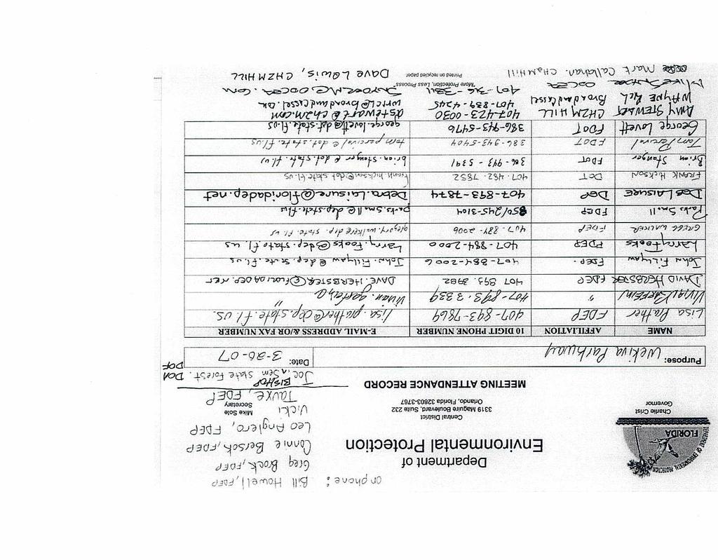
29 MEETING SUMMARY Wekiva Parkway PD&E Study Update - Viable Alternatives Meeting with Florida Dept. of Environmental Protection ATTENDEES: COPIES: Vivian Garfein, FDEP District Director Mike Snyder, OOCEA Executive Director Lisa Prather, FDEP File Aaron Watkins, FDEP Debra Laisure, FDEP David Herbster, FDEP Mark Callahan, CH2MHILL Dave Lewis, CH2MHILL FROM: Dave Lewis DATE: April 25, 2006 On April 20, 2006 at 1:30 p.m., the above listed attendees met in the Florida Department of Environmental Protection (FDEP) District Office at 3319 Maguire Blvd. in Orlando for an update on the Wekiva Parkway PD&E Study and a discussion of viable alternatives. Mark provided an update on the refinement of alternatives in Orange, Lake and Seminole Counties and displayed an aerial based plot of the overall alignment alternatives. He then displayed aerial based concept plots by county, including Orange County, the Wekiva Parkway/SR 46 Bypass systems interchange, west Lake County to US 441, Neighborhood Lakes alignment alternatives, CR 46A realignment, east Lake County access alternatives, and Seminole County. He also discussed traffic projections. District Director Garfein said FDEP doesn t want remnants of SR 46 used as in the split diamond concept for east Lake County access. With regard to the Seminole County concepts, she said the alternative connecting to the SR 417/I-4 interchange is the only way to go. Dave mentioned if widening in the SR 46 corridor in Seminole County is to the north of the existing right-of-way, that would impact approximately 6.5 acres of the Lower Wekiva River State Park. It was discussed that there needs to be coordination with FDEP on Wekiva Parkway mitigation and permitting activities. This summary is the writer s recollection of discussions at the meeting. MTG SUMMARY.GARFEIN DOC C-8

30 C-9

31 C-9

32 C-9
33 C-9
34 C-9
35 C-9
36 C-9
37 C-9

38 C-9

39 C-9

40 C-9

41 C-9

42 C-9

43 C-9
44 C-9
45 MEETING SUMMARY Wekiva Parkway Alignment and Access Issues Concerning State Lands in Lake and Seminole Counties ATTENDEES: FROM: See Attached Sign In Sheet Mark Callahan, P.E. DATE: July 31, 2007 A meeting was conducted on July 17, 2007 at Florida Department of Environmental Protection (FDEP) offices in Tallahassee, FL. The purpose of the meeting was for the Florida Department of Transportation (FDOT) and the Orlando-Orange County Expressway Authority (OOCEA) to provide a briefing to Senior FDEP staff and to specifically discuss outstanding key issues that have been identified during the course of the Wekiva Parkway Project Development and Environment (PD&E) Study. The agenda for the meeting and the sign in sheet are attached to this meeting summary. The meeting started with introductions of attendees. Mark Callahan of CH2M HILL, the consultant project manager for the PD&E Study, provided a history and overview of the Wekiva Parkway including the original studies in the late-1980s and the deliberations of the Wekiva Basin Area Task Force and Coordinating Committee. These efforts prompted the passage of the Wekiva Parkway and Protection Act in A review of the purpose and need of the project followed with emphasis on the growing congestion in the SR 46 corridor and the high number of crashes resulting in a significant number of fatalities. In addition, given the unique area the corridor traverses there are a notable number of wildlife/vehicle collisions resulting in animal mortality including the Florida Black Bear and other species. A brief discussion of current land use and land use control measures outlined in the Wekiva Parkway and Protection Act was undertaken. Wayne Rich of Broad and Cassel, representing the Orlando-Orange County Expressway, briefed the group on the land acquisition status. The Wekiva River Mitigation Bank property is the subject of an agreement between FDEP, OOCEA and FDOT for a conservation agreement for the property. The Neighborhood Lakes Property has been acquired through a funding agreement including FDEP, FDOT, St. Johns River Water Management District, OOCEA, Orange County, and Lake County. The Seminole Woods/Swamp parcels are owned by a family which has indicated/shown no interest in selling the property or providing for a conservation easement. The Pine Plantation parcels may be partially impacted by the Wekiva Parkway alignment but no other land acquisition funds are available for purchase of this property. At this point a review of the initial consultant recommendations along with briefing on additional input was reviewed for several key areas. The following provides a summary of the discussion. Alignment of Wekiva Parkway through the Neighborhood Lakes Property (Orange and Lake Counties) Three alignments were assessed (Alternative 1 (west), Alternative 2 (center), and Alternative 3 (east)). Assessments of the three alignments indicated similar impacts with Alternative 3 impacting 1 C-10
46 MEETING SUMMARY: WEKIVA PARKWAY ALIGNMENT AND ACCESS ISSUES CONCERNING STATE LANDS IN LAKE AND SEMINOLE COUNTIES a small neck of the Rock Springs Run. Alternative 1 is the closest option to the Mt. Plymouth neighborhood and there would be some moderate noise impacts. The Consultant Recommendation was for Alternative 1 given the similar impacts for the alignments and based on FDEP indicating their preference for Alternative 1 (west) since it provided the greatest contiguous holding with Rock Springs Run State Reserve. FDOT has requested that as the project moves forward more detailed floodplain boundaries will be defined and it is requested that FDEP work with FDOT on floodplain compensation in an effort to maximize cost efficiencies. CR 46A Realignment (Lake County) A single viable alternative (Alternative 1) for the CR 46A realignment was presented to the public in Concerns regarding the alignment were raised by residents of Heathrow Country Estates, a neighborhood to the west adjacent to the proposed alignment. Based on the input from the residents four additional alternatives were examined (Alternatives 1A, 1B, 1C, and 1D). Based on assessments of these additional alternatives it was noted that Alt. 1D does not appear to be consistent with the Wekiva Parkway and Protection Act. Alt. 1C impacts the western portions of the Seminole State Forest and it also impacts a karst area with a large floodplain. Alt. 1B is approximately 800 feet east of the original alignment and it bisects the private property it traverses. Alt. 1A is 50 feet east of the original alignment. Alternative 1A was the Consultant Recommendation for this area. Additional feedback was provided by the residents of Country Estates who suggest the alignment should be located in the Seminole Forest or 800 feet east of the original alignment. The Lake County Commission has requested the study team to look at an alignment located 100 feet east of the original alignment allowing for some existing vegetation and buffering to remain. Florida Department of Agriculture and Consumer Affairs have stated their concern about impacts to the Seminole State Forest. At this point FDOT is evaluating the Lake County request and is comfortable with that alignment or Alt 1A. FDEP indicated their preference as the westernmost options (Alternative 1, 1A or new option as per Lake County). Lake County East Access Alternatives A key issue for the portion of the Wekiva Parkway east of Neighborhood Lakes is how to provide access to private and State-owned lands while providing the desired habitat connectivity in this important area. Two basic schemes were developed: First a "split diamond interchange" concept and a "two full interchanges" concept. The split diamond provides a balance solution based on the projected traffic for this area representing less costs and right-of-way. The split diamond concept did require local traffic to use existing portions of SR 46 roughly between CR 46A and Wekiva River Road. The two full interchanges concept provided a high level of capacity not consistent with the land uses but did allow for closure of SR 46 between the two interchanges. The split diamond interchange was the consultant recommendation for access in this area. The Wekiva Commission (June 1, 2007 meeting) requested FDOT to consider the two full interchange concept given concerns about the existing portions of SR 46 remaining open with the split diamond alternative. In addition, the Lake County Commission (June 5, 2007 meeting) indicated a similar preference for the two full interchange concept. Discussion with FDEP mirrored concerns raised by the Wekiva Commission and the Lake County Commission. Essentially the continued use of portions of SR 46 will incrementally diminish with wildlife and habitat. FDEP emphasized that having the two interchanges concept and eliminating travel on the referenced segment of SR 46 was critical to their support of the Wekiva Parkway. 2 C-10
47 MEETING SUMMARY: WEKIVA PARKWAY ALIGNMENT AND ACCESS ISSUES CONCERNING STATE LANDS IN LAKE AND SEMINOLE COUNTIES Lake County East Alignment Alternatives In the same area of the project where the access issue is located there are three alternative alignments under consideration. The alignment alternatives in the "hump" area of SR 46 include the Red, Blue and Green Alternatives. The Red and Blue Options are very similar with locations approximately 1,400 feet south of the hump on SR 46. The Blue Alt. has slightly higher impacts than the Red. The Green alignment is located just south, and in some areas within, the existing SR 46 right-of-way. The basic impact trade-offs are the higher wetland, floodplain, and public land impacts for the Red and Blue Alts. and greater impacts to residents and higher costs for the Green alignment. The Consultant recommendation suggested elimination of the Blue Alternative and recommended the Red Alternative due to its lower cost and impacts to residents in the area. Furthermore the Green Alternative left property to the south with no access. FDEP indicated a preference for the Green Alignment because it provided more contiguous habitat in the area and had less impacts to public lands. Environmental Bridges (Lake County) The Guiding Principles established for the Wekiva Parkway included provisions for significant bridge structures to enhance habitat connectivity and to reduce wildlife collisions. The existing corridor has a bridge at the Wekiva River and two wildlife underpasses to the west. The total existing length of bridged area is approximately 600 feet. Original concepts for the bridges provided more extensive bridging in the same areas where there are structures today with the total bridged area at approximately 14,000 feet. FDOT remains concerned with the costs of this project recognizing it is an important transportation improvement which will also provide a significant environmental benefit when implemented. A value engineering study was perform for the project which brought forth several issues regarding bridge areas in the early concepts. These issues suggested pulling bridge limits off of interchange ramp and auxiliary lane areas and to reduce bridging in curve locations. By minimizing the amount of bridge structure it was recognized that the project would be more affordable and could possibly be implemented earlier. With this input adjustments have been undertaken with the bridge limits which brings the three bridge areas to a total of approximately 9,000 feet. Wildlife fencing will be installed to direct wildlife to the bridge locations. FDEP acknowledged that the proposed change although less than the early concept remains a significant enhancement to connectivity. A question was raised regarding funding of the project and it was indicated that FDOT does not reasonably foresee funds available for the project. That said FDOT will be exploring all options for funding which may include tolling on additional portions of the project and/or public/private partnerships. Wekiva River Mitigation Bank (Lake County) A discussion on the Wekiva River Mitigation Bank ensued wherein Mr. Rich provided some background on the agreement regarding the conservation easements. Part of the agreement includes language regarding the impact of the Wekiva Parkway to the number of mitigation credits approved for the entire property. Through this discussion FDEP indicated that the Green Alternative would have less impacts to the mitigation credits as compared to the Red Alternative. North or South Widening of SR 46 (Seminole County) East of the Wekiva River two alternatives were examined along the SR 46 corridor. The proposed improvement in Seminole County involve putting the Wekiva Parkway in the center of the right-of-way between two one-way frontage roads. This concepts requires approximately 270 feet of right-of-way. The existing right-of-way is 200 feet. The South Alternative involves acquiring right-of-way (approx. 70 feet) to the south which impacts a significant number of residential parcels. The North Alternative 3 C-10
48 MEETING SUMMARY: WEKIVA PARKWAY ALIGNMENT AND ACCESS ISSUES CONCERNING STATE LANDS IN LAKE AND SEMINOLE COUNTIES involves acquiring right-of-way to the north which impacts Lower Wekiva State Preserve and also impacts a major gas line within a 50 foot easement north of existing SR 46. Evaluations indicated that the North Alignment requires additional costs for the gas line relocation and easement. However, these costs are offset by the higher land values for the South Alternative. The Consultant identified the North Alternative as the Recommendation. The Seminole County Expressway Authority has indicated their preference for the North Alternative due to the potential impacts to the south. FDOT has committed to examine options to minimize impacts to the Lower Wekiva State Preserve as a part of the study as well as during design. Furthermore FDOT will work with FDEP Land Managers to identify other measures to minimize impacts to the preserve. FDEP indicated their preference for the South Alternative due to the impacts to Lower Wekiva State Preserve. FDEP did also acknowledge the difficulty of acceptance of the South Alternative to residents and County leaders. At this point in the meeting Bob Ballard of FDEP reviewed the agency's concerns as summarized above. He specifically emphasized the importance of the Two Interchanges in East Lake County and indicated a willingness to work with FDOT on the other issues. FDOT committed to re-examine the access and alignment alternatives in East Lake County. Also FDOT emphasized their commitment to work with FDEP to minimize the impacts to Lower Wekiva State Preserve. Attachments: Meeting Agenda Sign In Sheet 4 C-10
49 C-10
50
51

52
53
54
55
56
57
58
59
60

61

62

63
64
65
66 Information on Revision of the Wekiva Parkway Alternative in East Lake County* The Wekiva Parkway & Protection Act (Florida Statutes, 2004) required that SR 46 in east Lake County west of the Wekiva River not be a continuous roadway for environmental reasons. As recommended by the Lake County Commission, the Wekiva River Basin Commission, and the Florida Department of Environmental Protection (in keeping with the mandates of the Act), the plans for Wekiva Parkway in east Lake County eliminated SR 46 as a through road from the Neighborhood Lakes area eastward to the Wekiva River. Those are the Wekiva Parkway plans that the Division of Forestry (DOF) has seen previously in our Section 4(f) coordination. At the time the Act was passed, it was assumed the Wekiva Parkway would not be a tolled roadway. However, after an extensive financial analysis estimated the total cost of construction of the project at $1.8 billion, and with declining transportation dollars available to the Florida Department of Transportation (FDOT), it became evident that the Wekiva Parkway from SR 429 near Apopka in northwest Orange County through east Lake County to I-4 near Sanford in west Seminole County would not be financially feasible without tolls. Citizens in the east Lake County area who live and work along existing SR 46 expressed concerns over having to pay a toll for a local trip. Local and state elected officials also expressed those concerns on behalf of their constituents. In mid 2009, the Orlando-Orange County Expressway Authority (OOCEA) and FDOT began analyzing options to provide a non-tolled service road in east Lake County along the Wekiva Parkway route. In response to those citizen and elected official concerns, a service road concept has been developed. The service road, which would be parallel to and on the north side of the Wekiva Parkway in east Lake County, is within the 300 foot right-of-way previously identified for the Wekiva Parkway (attached are two graphics which depict the alignment and the typical section; please zoom in on the PDF of the alignment for greater detail). The alignment of the Wekiva Parkway has not been changed. The previous Wekiva Parkway alternative had two local access interchanges west of the Wekiva River in east Lake County due to the elimination of SR 46. With the service road, those interchanges are no longer needed and impacts to Seminole State Forest lands have been reduced by approximately 8.2 acres, as shown below. Previous Wekiva Parkway Alternative Wekiva Parkway Alternative with Service Road Estimated Impact Reduction Estimated Impact on Seminole State Forest Land 64.7 acres 56.5 acres 8.2 acres A Public Workshop on the service road alternative was held in Sorrento, Florida on December 17, FDOT and OOCEA are now moving ahead to revise the previous recommended Preferred Alternative for Wekiva Parkway in east Lake County to include the service road. We have been coordinating with Federal Highway Administration (FHWA) on the programmatic Section 4(f) evaluation for public lands, which includes Seminole State Forest. After you have had an opportunity to review this information on the service road and the resultant reduced impacts to Seminole State Forest, FHWA has indicated they would like to meet with DOF, FDOT and OOCEA in Tallahassee to discuss resolving the outstanding DOF concerns so we may reach agreement on Section 4(f) concurrence for potential proximity impacts and mitigation. I will contact you about the scheduling of and arrangements for that meeting with FHWA. In the meantime, if DOF has any questions about the service road concept, please contact Mr. Dave Lewis of CH2M HILL at (407) Ext * Information provided by Bob Gleason, FDOT District 5 to James Karels, DOF Director and Joe Bishop, Seminole State Forest Supervisor on February 8, 2010.
67 Information on Revision of the Wekiva Parkway Alternative in East Lake County* The Wekiva Parkway & Protection Act (Florida Statutes, 2004) required that SR 46 in east Lake County west of the Wekiva River not be a continuous roadway for environmental reasons. As recommended by the Lake County Commission, the Wekiva River Basin Commission, and the Florida Department of Environmental Protection (in keeping with the mandates of the Act), the plans for Wekiva Parkway in east Lake County eliminated SR 46 as a through road from the Neighborhood Lakes area eastward to the Wekiva River. Those are the Wekiva Parkway plans that Wekiva River Basin State Parks management has seen previously in our Section 4(f) coordination. At the time the Act was passed, it was assumed the Wekiva Parkway would not be a tolled roadway. However, after an extensive financial analysis estimated the total cost of construction of the project at $1.8 billion, and with declining transportation dollars available to the Florida Department of Transportation (FDOT), it became evident that the Wekiva Parkway from SR 429 near Apopka in northwest Orange County through east Lake County to I-4 near Sanford in west Seminole County would not be financially feasible without tolls. Citizens in the east Lake County area who live and work along existing SR 46 expressed concerns over having to pay a toll for a local trip. Local and state elected officials also expressed those concerns on behalf of their constituents. In mid 2009, the Orlando-Orange County Expressway Authority (OOCEA) and FDOT began analyzing options to provide a non-tolled service road in east Lake County along the Wekiva Parkway route. In response to those citizen and elected official concerns, a service road concept has been developed. The service road, which would be parallel to and on the north side of the Wekiva Parkway in east Lake County, is within the 300 foot right-of-way previously identified for the Wekiva Parkway (attached are two graphics which depict the alignment and the typical section; please zoom in on the PDF of the alignment for greater detail). The alignment of the Wekiva Parkway has not been changed. The previous Wekiva Parkway alternative had two local access interchanges west of the Wekiva River in east Lake County due to the elimination of SR 46. With the service road, those interchanges are no longer needed and impacts to Rock Springs Run State Reserve (RSRSR) lands have been reduced by approximately 29 acres, as shown below. Previous Wekiva Parkway Alternative Wekiva Parkway Alternative with Service Road Estimated Impact Reduction Estimated Impact on RSRSR Land acres 95.8 acres 29.0 acres A Public Workshop on the service road alternative was held in Sorrento, Florida on December 17, FDOT and OOCEA are now moving ahead to revise the previous recommended Preferred Alternative for Wekiva Parkway in east Lake County to include the service road. With regard to this revision, FDOT and OOCEA have been coordinating with the Federal Highway Administration on the programmatic Section 4(f) evaluation for public lands, which includes RSRSR. There has been recent coordination in Tallahassee between FDOT, OOCEA and FDEP Deputy Secretary Ballard on the service road concept and the resultant reduced impacts to RSRSR. Also, FDOT and OOCEA have been discussing with Deputy Secretary Ballard and FDEP legal counsel a letter agreement on Section 4(f) concurrence for potential proximity impacts and mitigation. This information is meant to provide an update on activities to the Wekiva River Basin State Parks management team. If you have any questions about the service road concept, please contact Mr. Dave Lewis of CH2M HILL at (407) Ext. 281 or by at David.Lewis2@ch2m.com. *Information provided to FDEP, Division of Recreation and Parks (Wekiva River Basin State Parks Manager Warren Poplin) on February 8, 2010.
68
69
70
71
72
73

74
SR 429/WEKIVA PARKWAY FTBA CONFERENCE March 20-21, Presented By Suzanne Phillips, P.E., FDOT District 5
 SR 429/WEKIVA PARKWAY FTBA CONFERENCE March 20-21, 2012 Presented By Suzanne Phillips, P.E., FDOT District 5 Project Description The Wekiva Parkway project constructs 25 centerline miles of new toll expressway.
ASSESSMENT OF MULTI-USE TRAIL ACCOMMODATION
 ASSESSMENT OF MULTI-USE TRAIL ACCOMMODATION WEKIVA PARKWAY (SR 429)/SR 46 REALIGNMENT PD&E STUDY Orange, Lake, and Seminole Counties, Florida Financial Project ID: 238275 1 22 01 and 240200 1 22 01 Federal
AGENDA ITEM 5 D WAKULLA ENVIRONMENTAL INSTITUTE (WEI) TRAIL FEASIBILITY STUDY
 TRAIL FEASIBILITY STUDY") March 19, 2018 AGENDA ITEM 5 D WAKULLA ENVIRONMENTAL INSTITUTE (WEI) TRAIL FEASIBILITY STUDY TYPE OF ITEM: Action STATEMENT OF ISSUE The Wakulla Environmental Institute (WEI) Trail is one of several trails
March 19, 2018 AGENDA ITEM 5 D WAKULLA ENVIRONMENTAL INSTITUTE (WEI) TRAIL FEASIBILITY STUDY TYPE OF ITEM: Action STATEMENT OF ISSUE The Wakulla Environmental Institute (WEI) Trail is one of several trails
Dungeness Recreation Area County Park Master Plan
 Dungeness Recreation Area County Park Public Outreach Meeting October 10, 2007 Project Overview USFWS Site Dungeness Recreation Area County Park Meeting Objectives: Re-Introduce project; provide status
WEKIVA WILD AND SCENIC RIVER ACT OF 2000
 PUBLIC LAW 106 299 OCT. 13, 2000 WEKIVA WILD AND SCENIC RIVER ACT OF 2000 VerDate 11-MAY-2000 01:59 Oct 20, 2000 Jkt 069139 PO 00000 Frm 00001 Fmt 6579 Sfmt 6579 E:\PUBLAW\PUBL299.106 APPS27 PsN: PUBL299
Segment 2: La Crescent to Miller s Corner
 goal of the USFWS refuges is to conserve, protect and enhance fish, wildlife and plants and their habitats for the continuing benefit of the American people. Refuge lands are used largely for fishing,
Flow Stand Up Paddle Board Parkway Plan Analysis
 Regional Parks Department Jeffrey R. Leatherman, Director County of Sacramento Divisions Administration Golf Leisure Services Maintenance Rangers Therapeutic Recreation Services Flow Stand Up Paddle Board
2. Goals and Policies. The following are the adopted Parks and Trails Goals for Stillwater Township:
 D. PARKS AND TRAILS 1. Introduction Stillwater Township s population is relatively low, with most residents living on rural residences on large lots. The need for active park space has been minimal in
Longmont to Boulder Regional Trail Jay Road Connection DRAFT FINAL REPORT
 Longmont to Boulder Regional Trail Jay Road Connection DRAFT FINAL REPORT December 2018 Project Summary Boulder County, Colorado, in partnership with the City of Boulder, is evaluating options for multi-use
White Mountain National Forest Saco Ranger District
 United States Department of Agriculture Forest Service White Mountain National Forest Saco Ranger District 33 Kancamagus Highway Conway, NH 03818 Comm: (603) 447-5448 TTY: (603) 447-3121 File Code: 1950
APPENDIX OFFICIAL MAP ORDINANCE OF HAMILTONBAN TOWNSHIP OFFICIAL MAP NARRATIVE
 APPENDIX A OFFICIAL MAP ORDINANCE OF HAMILTONBAN TOWNSHIP OFFICIAL MAP NARRATIVE INTRODUCTION: The Official Map of Hamiltonban Township has been prepared to identify those lands and features that Hamiltonban
United States Department of the Interior National Park Service. Boundary Expansion Listed in National Register January 11, 2017
 NPS Form 10900-a (Rev. 8/2002) OMB No. 10240018 United States Department of the Interior National Park Service Boundary Expansion Listed in National Register January 11, 2017 National Register of Historic
CHAPTER 6 NOISE EXPOSURE
 CHAPTER 6 NOISE EXPOSURE FAA requires that the NEM submitted for review represent the aircraft noise exposure for the year of submittal (in this case 2008) and for a future year (2013 for OSUA). However,
4.19 Parks, Recreation, and Conservation Lands
 interchange would have on the Reed Paige Clark Homestead located on the north side of Stonehenge Road. Alternative D would also affect Palmer Homestead, E.F. Adams House, and Knapp Brothers Shoe Manufacturing
RUSHMORE CONNECTOR TRAIL PROPOSAL
 PURPOSE AND NEED Background The U.S. Forest Service, Black Hills National Forest (Forest Service) has received a special use permit application from the State of South Dakota Department of Game, Fish and
Section II. Planning & Public Process Planning for the Baker/Carver Regional Trail began in 2010 as a City of Minnetrista initiative.
 Section II Planning & Public Process Planning for the began in 2010 as a City of initiative. city staff began discussions with the Park District on the possibility of a north/south regional trail connection
Business Item No
 Metropolitan Parks and Open Space Commission Meeting date: February 6, 2018 For the Community Development Committee meeting of February 20, 2018 For the Metropolitan Council meeting of February 28, 2018
Business Item No XXX. Proposed Action That the Metropolitan Council approve the Coon Creek Regional Trail Master Plan.
 Business Item No. 2015-XXX Metropolitan Parks and Open Space Commission Meeting date: July 7, 2015 For the Community Development Committee meeting of July 20, 2015 For the Metropolitan Council meeting
The Chu property is a 6.57 acre parcel located in the Town of Superior on the west side of McCaslin Boulevard. In 2014, the Town of Superior acquired
 1 The Chu property is a 6.57 acre parcel located in the Town of Superior on the west side of McCaslin Boulevard. In 2014, the Town of Superior acquired the Chu property for open space with a contribution
BRACEVILLE NATURE PRESERVE Introductions History Present Conditions Future Development Plans Implementation Strategies Statistics
 BRACEVILLE NATURE PRESERVE Introductions History Present Conditions Future Development Plans Implementation Strategies Statistics Introduction Braceville Nature Preserve is one of MetroParks largest preserves.
Pinellas County Environmental Lands
 Pinellas County Environmental Lands In addition to traditional parks and recreation facilities, Pinellas County owns and manages a system of environmental lands that provides specialized resource-based
Blue River Trail Master Plan JSA to Town Hall June 2004
 Blue River Trail Master Plan JSA to Town Hall June 2004 Prepared for: Silverthorne Town Council Silverthorne SPORT Committee Department of Recreation and Culture Silverthorne Public Works Silverthorne
Classifications, Inventory and Level of Service
 Classifications, Inventory and Level of Service Section 3 Kenmore Park, Recreation and Open Space Plan 1 P a g e Classifications and Inventory Park Classifications Kenmore classifies its parks based upon
Committee Report. Community Development Committee For the Metropolitan Council meeting of August 12, Business Item No.
 Committee Report Business Item No. 2015-168 Community Development Committee For the Metropolitan Council meeting of August 12, 2015 Subject: Coon Creek Regional Trail Master Plan, Anoka County Proposed
112th CONGRESS. 1st Session H. R. 113 IN THE HOUSE OF REPRESENTATIVES
 HR 113 IH 112th CONGRESS 1st Session H. R. 113 To provide for additions to the Cucamonga and Sheep Mountain Wilderness Areas in the Angeles and San Bernardino National Forests and the protection of existing
8 CROSS-BOUNDARY AGREEMENT WITH BRAMPTON TRANSIT
 8 CROSS-BOUNDARY AGREEMENT WITH BRAMPTON TRANSIT The Transportation Services Committee recommends the adoption of the recommendations contained in the following report dated May 27, 2010, from the Commissioner
4.0 Context for the Crossing Project
 4.0 Context for the Crossing Project This section provides background information about key features of the North Douglas Crossing project area, and opportunities and constraints. This information is important
David Johnson. Tom, Attached please find the final scoping letter and figures for your review. David
 David Johnson From: Sent: To: Cc: Subject: Attachments: David Johnson Tuesday, April 12, 2011 4:33 PM Thomas Malecek Dave Dyer; Jason Marks (jmarks@segroup.com) VWC Scoping Letter
THOMAS A. SWIFT METROPARK Introductions History Present Conditions Future Development Plans Implementation Strategies Statistics
 THOMAS A. SWIFT METROPARK Introductions History Present Conditions Future Development Plans Implementation Strategies Statistics Introduction As an open meadow park positioned along the Mahoning River,
MASTER PLAN EXECUTIVE SUMMARY
 Biscuit Run State Park Scottsville Road (State Route 20) Charlottesville, VA 22902 Biscuit Run State Park MASTER PLAN EXECUTIVE SUMMARY Department of Conservation and Recreation Division of Planning and
proof Northwest District
 1 Northwest District The Northwest Florida Water Management District is the most rural of all five water management districts. From just east of Tallahassee west to the Florida/Alabama line, and from the
CHAPTER 4 -- THE LAND USE PLAN: DESCRIPTIONS AND POLICIES FOR THIRTEEN PLANNING AREAS
 CHAPTER 4 -- THE LAND USE PLAN: DESCRIPTIONS AND POLICIES FOR THIRTEEN PLANNING AREAS NORTH CENTRAL CAC AREA LITTLE VALLEY ROAD TO JUG HANDLE CREEK PLANNING AREA This planning area includes Cleone, Noyo,
Whitefish Range Partnership Tentatively Approved by WRP 11/18/2013!Rec. Wilderness Page 1
 Whitefish Range Partnership Tentatively Approved by WRP 11/18/2013!Rec. Wilderness Page 1 Recommended Wilderness Background The Whitefish Range has a long management and legislative history associated
Continental Divide National Scenic Trail Legislative History and Planning Guidance
 Continental Divide National Scenic Trail Legislative History and Planning Guidance Legislation, Policy, and Direction Regarding National Scenic Trails The National Trails System Act, P.L. 90-543, was passed
City of Durango 5.8 FUNDING TRAILS DEVELOPMENT
 5.8 FUNDING TRAILS DEVELOPMENT The City has been successful in establishing dedicated local funding sources as well as applying for grants to develop the City s trail system, having received nearly $2.4
LAKE APOPKA NORTH SHORE ECO TOURISM. Strategic Action Plan 4/10/2014
 LAKE APOPKA NORTH SHORE ECO ECO-TOURISM TOURISM 4/10/2014 Strategic Action Plan The purpose of this report is to identify strategic actions for implementing a comprehensive ecotourism plan for the North
ANCLOTE COASTAL TRAIL ALTERNATIVES ANALYSIS STUDY
 ANCLOTE COASTAL TRAIL ALTERNATIVES ANALYSIS STUDY PASCO COUNTY MPO JULY 2015 PROJECT OVERVIEW... INTRODUCTION EXECUTIVE SUMMARY CONTEXT... TAMPA BAY AREA, PINELLAS, & PASCO COUNTY S MULTI-USE TRAIL PLANS
FNORTHWEST ARKANSAS WESTERN BELTWAY FEASIBILITY STUDY
 FNORTHWEST ARKANSAS WESTERN BELTWAY FEASIBILITY STUDY EXECUTIVE SUMMARY The 2030 Northwest Arkansas Regional Transportation Plan developed by the Northwest Arkansas Regional Planning Commission (NWARPC)
CHAPTER III: TRAIL DESIGN STANDARDS, SPECIFICATIONS & PERMITS
 CHAPTER III Trail Design Standards, Specifications & Permits This chapter discusses trail standards, preferred surface types for different activities, permits, and other requirements one must consider
At the time, the portion of the line through Eagle County remains wholly under the ownership of Union Pacific Railroad (UP).
.") Chapter 5 The Railroad Corridor as a Trail Corridor The intent of this chapter is to identify how the rail corridor, if available for lease or purchase in all or part, could be incorporated into the core
Chapter 5 The Railroad Corridor as a Trail Corridor The intent of this chapter is to identify how the rail corridor, if available for lease or purchase in all or part, could be incorporated into the core
1803 West Hwy 160 Monte Vista, CO (719) TTY (719)
 TTY (719)") USDA Forest Service Rio Grande National Forest http://www.fs.fed.us/r2/riogrande 1803 West Hwy 160 Monte Vista, CO 81144 (719)852-5941 TTY (719)852-6271 USDI Bureau of Land Management San Luis Valley Center
USDA Forest Service Rio Grande National Forest http://www.fs.fed.us/r2/riogrande 1803 West Hwy 160 Monte Vista, CO 81144 (719)852-5941 TTY (719)852-6271 USDI Bureau of Land Management San Luis Valley Center
Section 4(f) and Section 6(f) Technical Analysis
 and Section 6(f) Technical Analysis") WESTSIDE SUBWAY EXTENSION PROJECT Contract No. PS-4350-2000 Section 4(f) and Section 6(f) Technical Analysis Prepared for: Prepared by: WSP USA 851 SW Sixth Avenue, Suite 1600 Portland, Oregon 97204 FEBRUARY
WESTSIDE SUBWAY EXTENSION PROJECT Contract No. PS-4350-2000 Section 4(f) and Section 6(f) Technical Analysis Prepared for: Prepared by: WSP USA 851 SW Sixth Avenue, Suite 1600 Portland, Oregon 97204 FEBRUARY
S Central Coast Heritage Protection Act APRIL 21, 2016
 STATEMENT OF GLENN CASAMASSA ASSOCIATE DEPUTY CHIEF, NATIONAL FOREST SYSTEM U.S. FOREST SERVICE U.S. DEPARTMENT OF AGRICULTURE BEFORE THE UNITED STATES SENATE COMMITTEE ON ENERGY AND NATURAL RESOURCES
RE: Access Fund Comments on Yosemite National Park Wilderness Stewardship Plan, Preliminary Ideas and Concepts
 September 30, 2016 Superintendent Yosemite National Park Attn: Wilderness Stewardship Plan P.O. Box 577 Yosemite, CA 95389 RE: Access Fund Comments on Yosemite National Park Wilderness Stewardship Plan,
MESA COUNTY DEPARTMENT OF PUBLIC WORKS Administration - Building - Engineering Road and Bridge Traffic - Planning - Solid Waste Management
 MESA COUNTY DEPARTMENT OF PUBLIC WORKS Administration - Building - Engineering Road and Bridge Traffic - Planning - Solid Waste Management 200 S. Spruce St. P.O. Box 20,000 Grand Junction, Colorado 81502-5022
A CASE FOR COMPLETING THE JORDAN RIVER PARKWAY: A
 A CASE FOR COMPLETING THE JORDAN RIVER PARKWAY: A safe crossing at 9000 South and 850 West Proposed 9000 South Underpass Parkway Timeline Parkway, Trail, and Tourism Facts Blueprint Jordan River 1971 1973
White Mountain National Forest Saco Ranger District
 United States Department of Agriculture Forest Service White Mountain National Forest 33 Kancamagus Highway Conway, NH 03818 Comm: (603) 447-5448 TTY: (603) 447-3121 File Code: 1950 Date: February 26,
DRAFT GENERAL IMPLEMENTATION PLAN AND SPECIFIC IMPLEMENTATION PLAN MIDDLETON MUNICIPAL AIRPORT MOREY FIELD. Revised 12/12/03
 DRAFT GENERAL IMPLEMENTATION PLAN AND SPECIFIC IMPLEMENTATION PLAN MIDDLETON MUNICIPAL AIRPORT MOREY FIELD Revised 12/12/03 As recommended for approval by the Plan Commission General Project Description
Coast to Coast Connector Summit
 Project Partners Welcome to the Coast to Coast Connector Summit Winter Garden, Florida City Hall October 1, 2014 1 Why are we here? Objectives 1. Inform key stakeholders on the current state of the C2C
Piedra River Protection Workgroup Meeting #5 Feb. 21, 2012 Ross Aragon Community Center, Pagosa Springs
 Piedra River Protection Workgroup Meeting #5 Feb. 21, 2012 Ross Aragon Community Center, Pagosa Springs What happened at this meeting? - Identified conservation easements - Discussed In-stream Flows -
METROPOLITAN COUNCIL 390 North Robert Street, St. Paul, MN Phone (651) TDD (651)
 TDD (651)") DATE: March 27, 2012 METROPOLITAN COUNCIL 390 North Robert Street, St. Paul, MN 55101 Phone (651) 602-1000 TDD (651) 291-0904 TO: Metropolitan Parks and Open Space Commission FROM: Arne Stefferud, Planning
DATE: March 27, 2012 METROPOLITAN COUNCIL 390 North Robert Street, St. Paul, MN 55101 Phone (651) 602-1000 TDD (651) 291-0904 TO: Metropolitan Parks and Open Space Commission FROM: Arne Stefferud, Planning
10/25/2013. What is the SCORP?! 2013 Local Government Survey 2013 Statewide Public Survey Advisory Group Priority Areas Your Suggestions!
 COLORADO OUTDOOR RECREATION TRENDS RESULTS FROM THE SCORP AND STATEWIDE Colorado Outdoor Recreation Resource Partnership September 2013 PRESENTATION What is the SCORP?! 2013 Local Government Survey 2013
Lake Myra County Park. Wake County, North Carolina Community Forum #2 June 12, 2008
 Lake Myra County Park Wake County, North Carolina Community Forum #2 June 12, 2008 Welcome and Introduction Meeting Agenda Welcome Introductions of Project Team Master Plan Process Community Forum #1 Updates
Logo Department Name Agency Organization Organization Address Information 5700 North Sabino Canyon Road
 Logo Department Name Agency Organization Organization Address Information United States Forest Coronado National Forest 5700 North Sabino Canyon Road Department of Service Santa Catalina Ranger District
Parkland County Municipal Development Plan Amendment Acheson Industrial Area Structure Plan
 Parkland County Municipal Development Plan Amendment Acheson Industrial Area Structure Plan New Plan Acheson Industrial Area Structure Plan Amendment Parkland County Municipal Development Plan Board Reference
Blueways: Rivers, lakes, or streams with public access for recreation that includes fishing, nature observation, and opportunities for boating.
 Parks, Open Space and Trails PRINCE WILLIAM COUNTY 2008 COMPREHENSIVE PLAN TRAILS PLAN CONTENTS The components of the trails plan are: Intent Definitions Goals, Policies, and Action Strategies Trails Map
Daisy Dean Trail 628/619 ATV Trail Construction
 Background and Purpose and Need The Daisy Dean ATV Trail Construction Project is located in the Little Belt Mountains, Musselshell Ranger District, Lewis and Clark National Forest approximately 32 miles
Madison Metro Transit System
 Madison Metro Transit System 1101 East Washington Avenue Madison, Wisconsin, 53703 Administrative Office: 608 266 4904 Fax: 608 267 8778 TO: FROM: SUBJECT: Plan Commission Timothy Sobota, Transit Planner,
MINUTES OF THE SPECIAL MEETING OF THE LADY LAKE TOWN COMMISSION LADY LAKE, FLORIDA June 20, 2016
 MINUTES OF THE SPECIAL MEETING OF THE LADY LAKE TOWN COMMISSION LADY LAKE, FLORIDA The Special Meeting of the Lady Lake Town Commission was held in the Commission Chambers at Lady Lake Town Hall, 409 Fennell
Partners: Michigan California Timber Company Shasta-Trinity National Forest Pacific Crest Trail Association The Trust for Public Land
 Partners: Michigan California Timber Company Shasta-Trinity National Forest Pacific Crest Trail Association The Trust for Public Land Describe the project location, size, opportunities, and timing. Provide
PURPOSE AND NEED (CONCURRENCE POINT 1) NEW CANADA ROAD PROJECT FROM STATE ROUTE 1 (U.S. HIGHWAY 70) TO U.S. INTERSTATE 40
 NEW CANADA ROAD PROJECT FROM STATE ROUTE 1 (U.S. HIGHWAY 70) TO U.S. INTERSTATE 40") PURPOSE AND NEED (CONCURRENCE POINT 1) NEW CANADA ROAD PROJECT FROM STATE ROUTE 1 (U.S. HIGHWAY 70) TO U.S. INTERSTATE 40 Project Description The primary purpose of this project is to improve the major
PURPOSE AND NEED (CONCURRENCE POINT 1) NEW CANADA ROAD PROJECT FROM STATE ROUTE 1 (U.S. HIGHWAY 70) TO U.S. INTERSTATE 40 Project Description The primary purpose of this project is to improve the major
Sawtooth National Forest Fairfield Ranger District
 United States Department of Agriculture Forest Service Sawtooth National Forest Fairfield Ranger District P.O. Box 189 Fairfield, ID. 83327 208-764-3202 Fax: 208-764-3211 File Code: 1950/7700 Date: December
Conservation Area Management Statement
 Conservation Area Management Statement Miller Creek Wildlife Area Resolution #: Approval: Issue Date: Date of Last Revision: Table of Contents 1. Purpose....... 1 2. Property Description...... 1 2.1. Legal
Lake Erie Commerce Center Traffic Analysis
 LOCATION: East of NYS Route 5 at Bayview Road Town of Hamburg Erie County, New York PREPARED BY: Wendel Companies 140 John James Audubon Parkway Suite 200 Amherst, New York 14228 January 2012 i ii Table
Wallace Falls State Park Classification and Management Planning Stage 3 Preliminary Recommendations July 18, 2018 Sultan City Hall
 Wallace Falls State Park Classification and Management Planning Stage 3 Preliminary Recommendations July 18, 2018 Sultan City Hall Thanks for coming! This document contains State Parks preliminary recommendations
Chapter 4.0 Alternatives Analysis
 Chapter 4.0 Alternatives Analysis Chapter 1 accumulated the baseline of existing airport data, Chapter 2 presented the outlook for the future in terms of operational activity, Chapter 3 defined the facilities
April 10, Mark Stiles San Juan Public Lands Center Manager 15 Burnett Court Durango, CO Dear Mark,
 Mark Stiles San Juan Public Lands Center Manager 15 Burnett Court Durango, CO 81301 Dear Mark, We are pleased to offer the following comments on the draft San Juan Public Lands Center management plans
REQUEST FOR PLANNING COMMISSION ACTION
 REQUEST FOR PLANNING COMMISSION ACTION DATE: 06/03/09 ITEM NO: 5e Department Approval: Agenda Section: PUBLIC HEARINGS Item Description: Request by City of Roseville for the vacation of public right-of-way
Rockin River Ranch State Park
 Rockin River Ranch State Park Public Meeting No. 3 August 16 th, 2017 Arizona State Parks and Trails (ASPT) Welcome Executive Director Sue Black Park budget = $4 million Balance of recreation uses, environment,
Final Environmental Impact Statement for the Merced Wild and Scenic River. Comprehensive Management Plan, Yosemite National Park, Madera and Mariposa
 This document is scheduled to be published in the Federal Register on 02/26/2014 and available online at http://federalregister.gov/a/2014-04061, and on FDsys.gov DEPARTMENT OF THE INTERIOR 4312-FF NATIONAL
COASTAL CONSERVANCY. Staff Recommendation December 2, 2004 COYOTE HELLYER COUNTY PARK BAY AREA RIDGE TRAIL
 COASTAL CONSERVANCY Staff Recommendation December 2, 2004 COYOTE HELLYER COUNTY PARK BAY AREA RIDGE TRAIL File No. 04-057 Project Manager: Amy Hutzel RECOMMENDED ACTION: Authorization to disburse up to
A. From I-68 in Monongalia County, West Virginia to SR 6119 in Fayette County, Pennsylvania 1
 Mon-Fayette Transportation Project A. From I-68 in Monongalia County, West Virginia to SR 6119 in Fayette County, Pennsylvania 1 The Mon/Fayette Transportation Project (MFTP) from I-68 in West Virginia
FEDERAL HIGHWAY ADMINISTRATION NEVADA DEPARTMENT OF TRANSPORTATION ENVIRONMENTAL IMPACT STATEMENT RE-EVALUATION
 FEDERAL HIGHWAY ADMINISTRATION NEVADA DEPARTMENT OF TRANSPORTATION ENVIRONMENTAL IMPACT STATEMENT RE-EVALUATION Project Name: Boulder City/US 93 Corridor Study (Boulder City Bypass) Project Location: The
Stage 2 ION: Light Rail Transit (LRT) from Kitchener to Cambridge
 from Kitchener to Cambridge") Stage 2 ION: Light Rail Transit (LRT) from Kitchener to Cambridge Public Consultation Centre (PCC) No. 3 Please Sign-in Cambridge City Hall November 21, 2017 2:00 to 8:00pm Preston Memorial Auditorium
Stage 2 ION: Light Rail Transit (LRT) from Kitchener to Cambridge Public Consultation Centre (PCC) No. 3 Please Sign-in Cambridge City Hall November 21, 2017 2:00 to 8:00pm Preston Memorial Auditorium
Chapter 2: Summary of Existing Open Space System
 Chapter 2: Summary of Existing Open Space System In 1976, the Wake County Board of Commissioners established the Wake County Parks and Recreation Department in order to provide park facilities and programs
LOUISIANA Department of Culture, Recreation, & Tourism
 Management Plan Louisiana LOUISIANA Department of Culture, Recreation, & Tourism National Park Service U. S. Department of the Interior Management Plan Newsletter 2 Public Comment Summary for Dear Friends,
SR 934 Project Development And Environment (PD&E) Study
 Study") SR 934 Project Development And Environment (PD&E) Study Project Advisory Group Meeting March 1, 2018 State Road 934/NE/NW 79th Street from west of I-95 (NW 13th CT) to N. Bayshore Drive PD&E STUDY SR 934/NE/NW
SR 934 Project Development And Environment (PD&E) Study Project Advisory Group Meeting March 1, 2018 State Road 934/NE/NW 79th Street from west of I-95 (NW 13th CT) to N. Bayshore Drive PD&E STUDY SR 934/NE/NW
CHAPTER ONE LITERATURE REVIEW
 CHAPTER ONE LITERATURE REVIEW LITERATURE REVIEW This chapter summarizes the most recently published community impact studies and articles that relate to multiuse trails. The review focuses on publications
Community Development Department Council Chambers, 7:30 PM, December 20, 2012
 STAFF REPORT 2012-56P: Alley Vacation Community Development Department Council Chambers, 7:30 PM, December 20, 2012 To: From: Re: Paul Luke, Chairman, Skokie Plan Commission Mike Voitik, Planning Technician
Decision Memo Broken Wheel Ranch Equestrian Outfitter Special-Use Permit Proposed Action
 Decision Memo Broken Wheel Ranch Equestrian Outfitter Special-Use Permit USDA Forest Service Mississippi Bluffs Ranger District, Shawnee National Forest Jackson and Union Counties, Illinois Proposed Action
1.2 Corridor History and Current Characteristics
 SECTION 1 Description and Background of Study Area 1.1 Introduction This preliminary engineering report was prepared for the Alaska Department of Transportation and Public Facilities (ADOT&PF). It is part
TRUCKEE TAHOE AIRPORT DISTRICT BOARD OF DIRECTOR STAFF REPORT
 AGENDA ITEM: 11 TRUCKEE TAHOE AIRPORT DISTRICT BOARD OF DIRECTOR STAFF REPORT AGENDA TITLE: MEETING DATE: January 24, 2018 PREPARED BY: NTPUD Agency Partnership Opportunity, Multi-Use Trailhead Access
Stephens Rd. Nature Preserve
 Stephens Rd. Nature Preserve History Stephens Road Nature Preserve (SRNP) is a 350-acre nature preserve in Huntersville that comprises nine properties purchased between 1994 and 2008. Parcels included
Bradley Brook Relocation Project. Scoping Notice. Saco Ranger District. United States Department of Agriculture Forest Service
 Bradley Brook Relocation Project United States Department of Agriculture Forest Service Scoping Notice White Mountain National Forest February 2011 For Information Contact: Jenny Burnett White Mountain
The Baker/Carver Regional Trail is intended to
 Section V Design Guidance The Baker/Carver Regional Trail is intended to safely accommodate 183,000 annual visits, an array of non-motorized uses, a variety of skill levels, and persons with special needs.
Preferred Recreation Recommendations Stemilt-Squilchuck Recreation Plan March 2018
 Preferred Recreation Recommendations Stemilt-Squilchuck Recreation Plan March 2018 Below are the recommended recreation ideas and strategies that package together the various recreation concepts compiled
Rule Governing the Designation and Establishment of All-Terrain Vehicle Use Trails on State Land
 Rule Governing the Designation and Establishment of All-Terrain Vehicle Use Trails on State Land 1.0 Authority 1.1 This rule is promulgated pursuant to 23 V.S.A. 3506. Section 3506 (b)(4) states that an
DECISION MEMO. Rawhide Trail #7073 Maintenance and Reconstruction
 Page 1 of 6 Background DECISION MEMO USDA Forest Service Jefferson Ranger District Jefferson County, Montana Rawhide Trail #7073 is located in the Elkhorn Mountain Range approximately 10 miles east of
Silver Lake Park An Environmental Jewel for the Citizens of Prince William County
 Silver Lake Park An Environmental Jewel for the Citizens of Prince William County The Prince William Park Authority Mission Statement states: The Prince William County Park Authority will create quality
FINAL TESTIMONY 1 COMMITTEE ON RESOURCES UNITED STATES HOUSE OF REPRESENTATIVES. July 13, 2005 CONCERNING. Motorized Recreational Use of Federal Lands
 FINAL TESTIMONY 1 STATEMENT OF DALE BOSWORTH CHIEF Of the FOREST SERVICE UNITED STATES DEPARTMENT OF AGRICULTURE Before the SUBCOMMITTEE ON FORESTS AND FOREST HEALTH And the SUBCOMMITTEE ON NATIONAL PARKS,
DATE: January 19, WCA Governing Board. Johnathan Perisho, Project Manager. Mark Stanley, Executive Officer
 Item 14 DATE: January 19, 2017 TO: FROM: THROUGH: SUBJECT: WCA Governing Board Johnathan Perisho, Project Manager Mark Stanley, Executive Officer Item 14: Consideration of a resolution to accept an acquisition
Route 29 Solutions Projects
 Your guide to the Route 29 Solutions Projects For full details & continued engagement please visit www.route29solutions.org The Route 29 Solutions Package is a $230 million investment into the improvement
Cascade River State Park Management Plan Amendment
 This document is made available electronically by the Minnesota Legislative Reference Library as part of an ongoing digital archiving project. http://www.leg.state.mn.us/lrl/lrl.asp Cascade River State
JOSLIN FIELD, MAGIC VALLEY REGIONAL AIRPORT DECEMBER 2012
 1. Introduction The Federal Aviation Administration (FAA) recommends that airport master plans be updated every 5 years or as necessary to keep them current. The Master Plan for Joslin Field, Magic Valley
US 380 FEASIBILITY STUDY
 US 380 FEASIBILITY STUDY Denton County CSJ(s): 0135-10-061, 0135-10-062 Public Meeting(s): January 15 & 22, 2019 WELCOME US 380 Denton County Feasibility Study DALLAS DISTRICT PUBLIC MEETING January 15
D1 January 8, 2014 Public Hearing APPLICANT: HUNT CLUB FARM
 D1 January 8, 2014 Public Hearing APPLICANT: HUNT CLUB FARM PROPERTY OWNER: HUNT CLUB A-1- A, LLC. STAFF PLANNER: Kevin Kemp REQUEST: Modification of a Conditional Use Permit approved by the City Council
CHAPTER 1: INTRODUCTION
 CHAPTER 1: INTRODUCTION Purpose and Scope The information presented in this report represents the study findings for the 2016 Ronan Airport Master Plan prepared for the City of Ronan and Lake County, the
Wanaka Community Board 15 April Report for Agenda Item: 4
 Wanaka Community Board 15 April 2015 Department: Infrastructure Report for Agenda Item: 4 Mt Burke Station Stopping and Vesting of Road Purpose 1 To obtain the Board s support for a stakeholder agreement
EMERY COUNTY PUBLIC LAND MANAGEMENT ACT OF 2018 S. 2809/H.R. 5727
 EMERY COUNTY PUBLIC LAND MANAGEMENT ACT OF 2018 S. 2809/H.R. 5727 September 25, 2018 OVERVIEW The Emery County Public Land Management Act of 2018 is a significant step backwards for wilderness and conservation
Dusty Boots Unit II. Available Parcels and Informational Summary
 Dusty Boots Unit II Available Parcels and Informational Summary January 2008 Notice to Recipients Other Properties May be available upon Request. Please feel free to contact us with other requests as this