MESA COUNTY DEPARTMENT OF PUBLIC WORKS Administration - Building - Engineering Road and Bridge Traffic - Planning - Solid Waste Management
|
|
|
- Ashlyn Norris
- 5 years ago
- Views:
Transcription

1 MESA COUNTY DEPARTMENT OF PUBLIC WORKS Administration - Building - Engineering Road and Bridge Traffic - Planning - Solid Waste Management 200 S. Spruce St. P.O. Box 20,000 Grand Junction, Colorado Ph (970) Fax (970) PROJECT REVIEW November 26, 2012 PRO CUPR GATEWAY CANYONS AIR TOURS CONDITIONAL USE PERMIT REVIEW Property Owner(s): Representative(s): Location: Zoning: Reviewed/Presented by: Planning s Request: Staff Recommendation: John S. Hendricks John Williams Highway 141, Gateway, Colorado AFT Ron Quarles, Senior Planner Review the Conditional Use Permit for the Gateway Canyons Air Tours Continue the Gateway Air Tours Conditional Use Permit as approved in 2009, with changes to the conditions of approval that clarify intended approach and flight paths, and that expand opportunities for communication between the Gateway Air Tours and nearby residents. I. PROJECT SUMMARY The Planning Division Staff is presenting this application to the Board of County Commissioners for a review of the Conditional Use Permit granted for the Gateway Canyons Air Tours on June 16, In the summer of 2012, an affected property owner contacted the Code Compliance Services staff with a complaint related to the conditions of approval for air flights from the Gateway Canyons Air Tours runway located north of the Gateway Community. The complaint was made on the basis of observed Gateway Air Tour flights over the residential area. As a condition of approval in 2009, the Board of County Commissioners required that the flights at the facility avoid residential areas. Specifically Condition 8 was approved in the resolution as follows: 8. That commercial flight paths shall avoid residential areas to minimize the impact of noise. Upon consideration of the complaint, it was determined by staff and the attorney representing the Gateway Canyons Air Tours that the 2009 Conditional Use Permit should be reviewed by the Board of County Commission to clarify the intent of the condition as it specifically relates to the complaint and determine how the issue should be resolved for the benefit of the Gateway Air Tours and the affected resident. II. BACKGROUND/HISTORY The property utilized for the Gateway Air Tours CUP is located on both sides of Highway 141 approximately 1.5 miles northeast of the Gateway Community and consists of approximately 242 acres of land zoned Agricultural Forestry Transitional (AFT). An existing residence, the air strip, and associated structures are located on the south side of the highway. No structures are located on the north side of the highway. 1

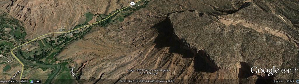
2 SITE The Palisade Gateway 2
3 Development of the site by the current owner began in 1997, with a request for conditional use permit approval (C203-97) for a private non-commercial air strip on the existing grass pasture area. The residence on the 242-acre site was constructed in conjunction with the airstrip. At that time, the CUP application stated: The aircraft to be used are short-field performance aircraft that can accomplish landings and take-offs within and can climb out steeply in the immediate area near the landing strip. For safety reasons, the owner desires to establish an area of at least 1,900 feet for the grass strip. At the time, the site which included an older home and out-buildings, was being developed for a Ranch Manager s house, a machine shop, a stable, and the main residence. The airstrip was to be limited to the private use of the owner. The Conditional Use Permit was granted by the Board of County Commissioners (MCM 93-53) with conditions that limited the grass air strip to private non-commercial uses and to flights during the day light hours. Fencing was also required to prevent cattle from adjacent properties from roaming on to the air strip. The original CUP application was brought back to the Board of County Commissioners nearly a decade later ( CUP) to allow the use to expand to a commercial airstrip. Since the original approval, the strip had increased in size from 1,900 feet in length to 2,673 feet. The application was made to allow the use, which had operated as an accessory use to the ranch and residence, to expand to include scenic airplane and helicopter tours operated by the Gateway Canyons Private Air Tours. The expanded use was to be limited to guests shuttled from the Gateway Canyons Resort to the site. The application was granted by the Board to allow commercial flights from aircraft belonging to the owner or his holdings associated with the Gateway Canyons Resorts (MCM ). The CUP prohibited public use of the airstrip for other individuals. The number of commercial fixed wing flights was limited to an average of 40 flights per month and flight paths were required to avoid residential areas. Staff is bringing the Conditional Use Permit to the Board for review based on complaints from an affected residential property owner south of the air strip that contends the established flight plan for take-offs and landings has been violated. This report will include a summary of complaints and flying activities at the air strip, and an analysis of the conditions of approval and the May 12 hearing proceedings, at which the conditions were implemented. III. SUMMARY OF COMPLAINTS AND AIR STRIP ACTIVITIES: Since the Conditional Use Permit was approved in June of 2009, a total of 486 take-offs and landings, for both personal and business flights, have been logged by the pilot at the airstrip. Of those, 244 flights were by the larger turbine-powered Cessna Caravan and 242 were by the smaller piston-engine Maule. The Cessna Caravan is utilized by the Gateway Canyons Air Tours for up to 6 passenger tour events. Since the commercial air tour operations have started, the owner of a residence located south of the airstrip at Highway 141, has submitted two separate citizen complaints on flight activities. The first complaint received on May 16, 2011 contended that aircraft flew over the property in violation of the amended CUP. However, the complaint was closed in October of that year after it was determined by the Code Compliance Officer that a violation had not occurred. The most recent complaint from the same property owner was submitted the following year on May 16, 2012, contending that an observed flight out of and back to the airstrip violated the established flight plan for take-offs and landings of the CUP by flying over the owner s residence. 3
4 In the letter submitted to the Code Compliance Services staff, the owner of the residence at Highway 141 observed a flight from the airstrip at about 8:30 a.m. and a flight at about 9:30 a.m. returning back to the airstrip. The resident complained that the airplane flew directly above the property at a very low altitude. The basis for the complaint by the residence was that the observed flights on May 13, 2012 were in violation of the Conditional Use Permit granted in As stated in the complaint: Flying over our property, and residential properties is prohibited by the amended CUP. The established flight plan for take-offs and landings has been violated. Therefore, Gateway Canyons Air Tours is in direct violation of the CUP. Upon discussions with the Code Compliance Office, and the attorney for the Gateway Canyons Tours, and in light of the complaints concerning aircraft activity, the CUP approved in June of 2009 (MCM ) was scheduled for this review by the Board of County Commissioners. IV. SUMMARY OF MAY 12, 2009 BOCC PUBLIC HEARING - CONDITIONS OF APPROVAL Following a 3-hour hearing on May 12, 2009, the Board of County Commissioners voted to amend the 1998 CUP (West Creek Ranch Airstrip) by expanding the use of the private airstrip along Highway 141 for commercial flights for scenic airplane and helicopter tours. At that hearing, eight speakers from the community addressed the Board with concerns related to the use of the airstrip. Although a variety of topics were addressed at the hearing, including the mitigation of impacts to critical wildlife areas, analysis in this report is limited to the specific issues associated with the May 16 complaint. Noise Impacts /Take-Offs and Landings As part of the application in 2009 to expand the use of the private air strip for commercial air flights, the applicant submitted a noise impact study prepared by D.L Adams Associates Incorporated. The purpose for the study was to assess potential noise impacts to the adjoining residential areas and to recommend any measures to mitigate those impacts. Sound levels were measured at three residential locations along Highway 141 in the general alignment of the air strip if it extended beyond the end of the runway. Noise was measured from approach and departure flights from aircraft and then compared to the normal (ambient) sound levels in the environment. According to the study the loudest conditions were observed at the time the aircraft departed the runway in the direction of Highway 141 and flew directly over the two residential areas closest to the airstrip where the measurements were being taken. In order to mitigate the noise impacts the study concluded that departures from the airstrip can be directed so that the aircraft do not follow Highway 141 and do not pass directly over the residences. Specifically, according to the study, take-offs with a turn to the east of the residential area reduced the sound levels significantly compared to the straight take off and departure. At the hearing in 2009, the owner of the airstrip anticipated adjustment of the flight paths to align east of the residential areas as a part of the Conditional Use Permit approval. The following slide was presented by the owner at the hearing to demonstrate the reduction of noise that would result by the realignment of the flight path to the east. As indicated, the shift would produce noise no greater than large trucks on Highway

5 Slide from Applicant s 2010 Presentation The findings in the noise study and the commitment of the owner to shift the flight path to the east was the basis for condition 8 in the approved Conditional Use Permit: That commercial flight paths shall avoid residential areas to minimize the impact of noise. The condition, as written, was intended to mitigate impacts from the loudest noise that occurred with take offs. However, it is not clear that the condition was intended to address aircraft landings since noise impacts from landings were not specifically addressed in the noise impact study or discussed at the hearing. For purposes of addressing the most recent complaint of both take offs and landings, staff requested additional information from the representative for the Air Tours to compare noise levels between landings and take-offs. According to a letter dated July 12, 2012 from the pilot, aircraft is always at a reduced power setting as it makes its final approach to landing. As a comparison, the power setting for normal cruise is 1,500 to 1,600 ft/lb of Torque, while the final approach power setting is ft/lb of Torque, suggesting that the noise levels are reduced for landings. In addition, the normal approach route into the airstrip was from the east parallel to the runway at 1000 feet above ground level, before the air plane turns back towards the air strip at 500 feet and then 400 feet above the ground level. On October 23, staff met with the representative for the Gateway Canyons Air Tours and the pilot to discuss more specifically the typical departure and approach routes in terms of the proximity to the property associated with the complaints. The pilot confirmed the typical approach route identified in the July 12 letter, however with the clarification that the air plane does not typically fly directly over the residential property but rather aligns directly with the runway as the final approach is made. As further clarification, the pilot identified the specific traffic pattern indicators from the Federal Aviation Administration (FAA) Aeronautical Information Manual (AIM) that stipulates the general flight patterns for the air strip. Both approaches and departures are made from the west end of the air strip for the Gateway Air Tours, and not from the opposite sides of the runway as the chart would suggest. Approaches to the air strip are from the east parallel on the north side, before the air plane turns directly into the runway as indicated by the earlier comments. Departures are made, again, from the same side of the runway, with a turn towards the southeast away from the residential areas. 5
6 Conditions of Approval Regardless of the typical flight patterns described by the pilot, staff recognizes the complaints that have been made by the affected resident based on personal observations and perceptions. Staff met with the affected owner on November 19, 2012 to discuss possible ways to address the impacts. The owners expressed a desire that the pilot of the aircraft observe flight patterns farther from the residential areas as was anticipated with the 2009 approval. Based on the information that was provided by the pilot and the input of the affected resident, staff is recommending that the conditions of approval for the Gateway Air Tours CUP be modified with specific references to the FAA Flight Pattern Indicators found in the FAA Aeronautical Information Manual, and that Gateway Air Tours expand its communication with the affected residents and property owners in proximity to the air tours operations. Specifically, staff is recommending Condition 8 and Condition 9 as follows: 8. The flight paths on both take-offs and landings shall avoid residential areas in an effort to minimize noise impacts to homes close to the air strip. The flight path for fixed wing aircraft on take-offs to the west shall involve turning the aircraft to the left after take-off. Flight paths for fixed wing aircraft on landings will be in accordance with the Air Traffic Indicators found in the FAA Aeronautical Information Manual illustrated in Exhibit A, or be on a straight line from the west flying on the north side of Highway 141 until the approach intersects with Highway 141. Flight paths over residential properties shall occur only for safety and weather related reasons, as determined at the sole discretion of the pilot of the aircraft. 9. A representative of Gateway Canyons Air Tours or the Hendricks family will meet on an annual basis with area residential property owners and/or the Gateway Property Owners Association to discuss air flight activities, and provide information on anticipated regular and seasonal flight schedules. Exhibit A Traffic Pattern Operations Single Runway Source: FAA Aeronautical Information Manual Chapter 4 Air Traffic Control 6

7 Approximate Approach and Take-off Alignments based on FAA Air Traffic Indicators V. NOTICE A postcard giving notice of the date, time and location of the December 3 public hearing was sent to all property owners within a 2,500 foot radius of the Properties. Notice was also posted on site and published as required by Chapter Three of the Mesa County Land Development Code. VI. PUBLIC COMMENTS: No comments were received as of the date of this report. IV. RECOMMENDATION The Public Works Department Planning Division recommends that: The Gateway Air Tours Conditional Use Permit remains in effect as approved in 2009 and in 1998, however with the following changes as previously stated. The original 1998 conditions of approval, as they were modified in 2000, have also been incorporated into the language of the conditions of approval. 1. All review agency comments shall be addressed that are not in conflict with the following conditions of approval. 2. All ooriginal conditions of approval as identified with Resolution MCM No , with the exception of condition of approval No. 3 which shall be changed to commercial uses, shall remain in effect as follows: a. The requirements of the Federal Aviation Administration shall be followed. b. Aircraft shall be limited to only short-field performance aircraft. c. The airstrip shall be for the private commercial use of the property. d. The air strip surface shall be maintained with grass to control dust. 7
8 3. There shall be no public use of the airfield, only aircraft belonging to Mr. John Hendricks or his holdings associated with Gateway Canyons Resorts. 4. Hours of operation shall be during the daylight hours. 5. A Major Site Plan shall be applied for and approved to show compliance with the Mesa County Development Code and the requirements of this application prior to construction of any hangar space. 6. Gateway Canyons Air Tours shall inform the BLM, Colorado Division of Wildlife and the U.S. Forest Service of its intended patterns and of any changes to established patterns in the future, and to work with these agencies to mitigate harmful effects on wildlife. In particular Gateway Canyons Air Tours will: A) Avoid elk and deer winter range areas for the time period of December 1 through April 1 of each year; B) Avoid raptor nesting areas along the cliffs of the Dolores River from late March until early July each year; C) Will not use its flights to improve hunting success, knowing it is illegal to fly hunters over hunting area close to hunting season to gain an advantage; D) Will not use its best efforts to maintain a minimum of 2,000 feet Above Ground Level (AGL) over the mapped sensitive areas and times. 7. That commercial fixed wing flights shall be limited to an average of 40 flights per month. 8. The commercial flight paths on both take-offs and landings shall avoid residential areas in an effort to minimize the impact of noise impacts to homes close to the air strip. The flight path for fixed wing aircraft on take-offs to the west shall involve turning the aircraft to the left after take-off. Flight paths for fixed wing aircraft on landings will be in accordance with the Air Traffic Indicators found in the FAA Aeronautical Information Manual illustrated in Exhibit A, or be on a straight line from the west flying on the north side of Highway 141 until the approach intersects with Highway 141. Flight paths over residential properties shall occur only for safety and weather related reasons, as determined at the sole discretion of the pilot of the aircraft. 9. A representative of Gateway Canyons Air Tours or the Hendricks family will meet on an annual basis with area residential property owners and/or the Gateway Property Owners Association to discuss air flight activities, and provide information on anticipated regular and seasonal flight schedules. Bases For Recommendation 1. A letter of complaint dated May 16, 2012 was received by Mesa County from the owner of property at Highway 141 in Gateway concerning observed flights over the affected property. 2. The complaint was made on the basis that the observed flights were perceived to be in direct violation of the Gateway Air Tours CUP (MCM ). 3. According to the letter of complaint, the affected owner has requested additional information on the intended flight path of the Gateway Air Tours. 4. As a condition of the 2009 approval for the Gateway Canyons Air Tours (Condition 8), commercial flight paths shall avoid residential areas to minimize the impact of noise. 5. The condition of approval was based on a Noise Impact Study prepared by D.L. Adams & Associates that determined the loudest noise occurred from take-offs over the affected residential areas, while take offs east of the residential areas would reduce noise significantly. 6. The condition, as approved in 2009, lacks clarity concerning approach and take off flight patterns. 7. The recommended change to the condition of approval would require that both approach and take-off flights avoid residential areas, except when the pilot determines other routes for safety and weather related reasons. 8
9 8. The recommended addition of Condition 9 would provide an opportunity for the Gateway Air Tours to inform nearby residents of its commercial operations, and establish a basis for regular communication between the Gateway Air Tours and the residential property owners. VII. BOARD OF COUNTY COMMISSIONERS DECISION: December 3,
Reliever Airports: NOISE ABATEMENT PLAN Flying Cloud Airport (FCM)
") Reliever Airports: NOISE ABATEMENT PLAN Flying Cloud Airport (FCM) INTRODUCTION The Noise Abatement Plan (FCM Plan) for the Flying Cloud Airport has been prepared in recognition of the need to make the
Reliever Airports: NOISE ABATEMENT PLAN Flying Cloud Airport (FCM) INTRODUCTION The Noise Abatement Plan (FCM Plan) for the Flying Cloud Airport has been prepared in recognition of the need to make the
PLAN Anoka County - Blaine Airport
 Reliever Airports: NOISE ABATEMENT PLAN Anoka County - Blaine Airport INTRODUCTION The noise abatement plan for the Anoka County-Blaine Airport was prepared in recognition of the need to make the airport
FRENCH VALLEY AIRPORT (F70) Sky Canyon Dr. Murrieta, CA. Phone: Riverside FAA FSDO Complaint Line: (951)
 Sky Canyon Dr. Murrieta, CA. Phone: Riverside FAA FSDO Complaint Line: (951)") FRENCH VALLEY AIRPORT (F70) 37600 Sky Canyon Dr. Murrieta, CA Phone: 951-600-7297 Riverside FAA FSDO Complaint Line: (951) 276-6701 Visit the F70 website for additional information regarding the airport
FRENCH VALLEY AIRPORT (F70) 37600 Sky Canyon Dr. Murrieta, CA Phone: 951-600-7297 Riverside FAA FSDO Complaint Line: (951) 276-6701 Visit the F70 website for additional information regarding the airport
Vista Field Airport. Master Plan Update. February, Prepared for: Port of Kennewick One Clover Island Kennewick, Washington
 Vista Field Airport February, 2006 Prepared for: Port of Kennewick One Clover Island Kennewick, Washington 99336 Prepared by: J-U-B ENGINEERS, Inc. 2810 W. Clearwater Avenue, Suite 201 Kennewick, Washington
St. Paul Downtown Airport (STP)
") Reliever Airports: NOISE ABATEMENT PLAN St. Paul Downtown Airport (STP) 1 INTRODUCTION The noise abatement plan for the St. Paul Downtown Airport (STP) was prepared in recognition of the need to make the
Reliever Airports: NOISE ABATEMENT PLAN St. Paul Downtown Airport (STP) 1 INTRODUCTION The noise abatement plan for the St. Paul Downtown Airport (STP) was prepared in recognition of the need to make the
INDEPENDENCE STATE AIRPORT (7S5)
") INDEPENDENCE STATE AIRPORT (7S5) Airport Master Plan Update 2018 Planning Advisory Committee PAC Meeting #3 April 11, 2018 1994-2016 AGENDA The second PAC workshop will cover the following topics: Recap
INDEPENDENCE STATE AIRPORT (7S5) Airport Master Plan Update 2018 Planning Advisory Committee PAC Meeting #3 April 11, 2018 1994-2016 AGENDA The second PAC workshop will cover the following topics: Recap
New Opportunities PUBLIC WORKSHOP. Venice Municipal. Bringing g the pieces together
 Bringing g the PUBLIC WORKSHOP Venice Municipal Airport New Opportunities Presented for Venice City Council & Citizens of Venice September 25, 2009 Slide 1 Bringing g the Welcome & Introductions May 12th
Hearings will be held in the Shirley Huffman Auditorium in the Charles D. Cameron Public Services Building, 155 North First Avenue, Hillsboro, Oregon.
 Hearings will be held in the Shirley Huffman Auditorium in the Charles D. Cameron Public Services Building, 155 North First Avenue, Hillsboro, Oregon. On September 24, 2013, the Board of County Commissioners
BUSINESS OF THE CITY COUNCIL CITY OF MERCER ISLAND, WA
 BUSINESS OF THE CITY COUNCIL CITY OF MERCER ISLAND, WA AB 4564 September 7, 2010 Regular Business RENTON AIRPORT STATUS UPDATE Proposed Council Action: Receive update. No action required. DEPARTMENT OF
Noise Oversight Committee
 Noise Oversight Committee May 8, 2014 Audio/Video recordings are made of this meeting 1 Item 1 Review and Approve Draft Meeting Minutes Minutes from March 19, 2014 2 Item 2 Review of Operations Report
National Transportation Safety Board Recommendation and FAA Air Traffic Orders
 Page 1 of 8 MEMORANDUM TO: Planning, Development and Environment Committee FROM: Chad E. Leqve, Director Environment (725.6326) SUBJECT: NOISE OVERSIGHT COMMITTEE (NOC) CONVERGING RUNWAY OPERATION (CRO)
Document prepared by MnDOT Office of Aeronautics and HNTB Corporation. MINNESOTA GO STATE AVIATION SYSTEM PLAN
 LAST UPDATE JULY 2013 Acknowledgements The preparation of this document was financed in part by a grant from the Federal Aviation Administration (Project No: 3-27-0000-07-10), with the financial support
KVNY HIGH. Van Nuys Airport Van Nuys, California, United States
 Diagram #1: Van Nuys Abatement and Curfew Regulation Page 1 Aircraft Categories: A, B & C / All Runways p. 1 of 20 Diagram #2: Van Nuys Abatement and Curfew Regulation Page 2 p. 2 of 20 Diagram #3: Van
Appendix D Project Newsletters. Tacoma Narrows Airport. Master Plan Update
 Appendix D Project Newsletters Tacoma Narrows Airport Master Plan Update This appendix contains the newsletters distributed throughout the project. These newsletters provided updates and information on
Buchanan Field. Airport Planning Program. FAR Part 150 Meeting. September 28, Master Plan FAR Part 150 Noise Study Strategic Business Plan
 Airport Planning Program Master Plan FAR Part 150 ise Study Strategic Business Plan FAR Part 150 Meeting September 28, 2006 Agenda Introduction Part 150 Study Working Paper Two Operational Alternatives
SFAR 93 and Minimum Altitudes
 SFAR 93 and Minimum Altitudes Stuart W. Goering FAA Aviation Safety Counselor 1/14/2003 22:12 Copyright 2003 Stuart W. Goering 1 You Make the Call Too Low or Just Fine? 1/14/2003 22:12 Copyright 2003 Stuart
Executive Summary. MASTER PLAN UPDATE Fort Collins-Loveland Municipal Airport
 Executive Summary MASTER PLAN UPDATE Fort Collins-Loveland Municipal Airport As a general aviation and commercial service airport, Fort Collins- Loveland Municipal Airport serves as an important niche
Dallas Executive Airport Town Hall Meeting April 3, 2014
 Dallas Executive Airport Town Hall Meeting April 3, 2014 Background 1,040 acre general aviation facility owned and operated by the City of Dallas 150 based aircraft including business jets and helicopters,
CHAPTER 6 NOISE EXPOSURE
 CHAPTER 6 NOISE EXPOSURE FAA requires that the NEM submitted for review represent the aircraft noise exposure for the year of submittal (in this case 2008) and for a future year (2013 for OSUA). However,
Norman Y. Mineta San Jose International Airport Annual Noise Report
 Norman Y. Mineta San Jose International Airport 2015 Annual Noise Report Annual Noise Report for Norman Y. Mineta San José International Airport Introduction and Purpose The purpose of this annual report
The Mount Vernon Council of Citizens Associations, Inc.
 The Mount Vernon Council of Citizens Associations, Inc. P.O. Box 203, Mount Vernon, VA 22121-9998 http://www.mvcca.org Mike Rioux JDA Aviation Technology Solutions 4720 Montgomery Lane Suite 950 Bethesda,
Addendum - Airport Development Alternatives (Chapter 6)
") Bowers Field Addendum - Airport Development Alternatives (Chapter 6) This addendum to the Airport Development Alternatives chapter includes the preferred airside development alternative and the preliminary
Bowers Field Addendum - Airport Development Alternatives (Chapter 6) This addendum to the Airport Development Alternatives chapter includes the preferred airside development alternative and the preliminary
STAFF REPORT. Airport Land Use Consistency Determination Betteravia Plaza. MEETING DATE: January 21, 2016 AGENDA ITEM: 8D
 STAFF REPORT SUBJECT: Airport Land Use Consistency Determination Betteravia Plaza MEETING DATE: AGENDA ITEM: 8D STAFF CONTACT: Andrew Orfila RECOMMENDATION: Adopt findings for the Betteravia Plaza project
Summary of Committee Discussion/Questions Metropolitan Transportation Services Senior Planner Russ Owen presented this item.
 Committee Report Business Item No. 2017-191 Transportation Committee For the Metropolitan Council meeting of September 13, 2017 Subject: Final Crystal Airport 2035 Long Term Comprehensive Plan (LTCP) Proposed
KSBP HIGH. San Luis County Rgnl Airport San Luis Obispo, California, United States
 Diagram #1: Runway 29 Departure Guide All Aircraft Categories / Runway 29 p. 1 of 8 Diagram #2: Runway 11 Departure Guide All Aircraft Categories / Runway 11 p. 2 of 8 NOISE ABATEMENT PROCEDURES by Whispertrack
ACTION TRANSMITTAL
 Transportation Advisory Board of the Metropolitan Council of the Twin Cities ACTION TRANSMITTAL 2018-16 DATE: February 9, 2018 TO: Transportation Advisory Board FROM: Technical Advisory Committee PREPARED
STAFF REPORT. Airport Land Use Plan Consistency Review: Old Town Village Mixed Use Project City of Goleta. MEETING DATE: June 18, 2015 AGENDA ITEM: 5M
 STAFF REPORT SUBJECT: Airport Land Use Plan Consistency Review: Old Town Village Mixed Use Project City of Goleta MEETING DATE: AGENDA ITEM: 5M STAFF CONTACT: Peter Imhof, Andrew Orfila RECOMMENDATION:
Flying Cloud Airport Joint Airport Zoning Board. 27 February 2018 Public Hearing #1 Overview of Proposed Airport Zoning Ordinance
 Flying Cloud Airport Joint Airport Zoning Board 27 February 2018 Public Hearing #1 Overview of Proposed Airport Zoning Ordinance Presentation Agenda Purpose & Goals Review of FCM Zoning Historical Timeline
Norman Y. Mineta San José International Airport 2017 Annual Noise Report
 Norman Y. Mineta San José International Airport 2017 Annual Noise Report Annual Noise Report for Norman Y. Mineta San José International Airport Introduction and Purpose The purpose of this annual report
KHND MEDIUM. Henderson Executive Airport Las Vegas, Nevada, United States. Diagram #1: Airport Map All Aircraft Categories / All Runways
 Diagram #1: Airport Map http://whispertrack.com/airports/ p. 1 of 5 Diagram #2: Abatement Chart http://whispertrack.com/airports/ p. 2 of 5 OVERVIEW To reduce noise over adjacent residential areas, please
Limited English Proficiency Plan
 Limited English Proficiency Plan City of Boulder City Boulder City Municipal Airport Title IV Program, 49 CFR 21 About The Airport Boulder City Municipal Airport (BVU) is the third busiest airport in the
KSMO HIGH. Santa Monica Muni Airport Santa Monica, California, United States
 Diagram #1: Airport Diagram with Monitors and Turbine Aircraft Hold Areas Aircraft Categories: A, B, C, D & E / Runways: 03 & 21 p. 1 of 7 NOISE ABATEMENT PROCEDURES by Whispertrack Diagram #2: Monitors
FORECASTING FUTURE ACTIVITY
 EXECUTIVE SUMMARY The Eagle County Regional Airport (EGE) is known as a gateway into the heart of the Colorado Rocky Mountains, providing access to some of the nation s top ski resort towns (Vail, Beaver
Comparison Between Old and New ALUC Plans
 A P P E N I X H Comparison Between Old and New ALUC Plans OVERVIEW This Placer County Airport Land Use Compatibility Plan (ALUCP) sets forth land use compatibility criteria for the environs of Auburn Municipal,
NOISE ABATEMENT PLAN. St. Paul Downtown Airport Holman Field
 NOISE ABATEMENT PLAN St. Paul Downtown Airport Holman Field MAC Department of Environment Office of Aviation Noise and Satellite Programs June 2008 1 INTRODUCTION The noise abatement plan for the St. Paul
SUBJECT: 2016 ANNUAL NOISE REPORT DATE: April 18, 2017 INFORMATION
 CITY OF SAN JOSE CAPITAL OF SILICON VALLEY Memorandum TO: HONORABLE MAYOR AND CITY COUNCIL FROM: Kimberly J. Becker SUBJECT: 2016 ANNUAL NOISE REPORT DATE: April 18, 2017 Approved Date 11ts 11* INFORMATION
TABLE OF CONTENTS 1.0 INTRODUCTION...
 Advisory Circular Subject: Passenger Safety Briefings Issuing Office: Standards Activity Area: Qualifying Document No.: AC 700-012 File No.: A 5500-15-1 U Issue No.: 01 RDIMS No.: 4121804-V11 Effective
During all other times operators are required to use the designated run-up locations for run-ups above idle power.
 OVERVIEW Thank you for your interest in the Portland International Airport Management Program. We appreciate your commitment to noise abatement and helping us remain good neighbors. The Port of Portland
Table of Contents Subject Page Paragraph
 Field Rules For Helicopters And Planes Effective August 2014 Table of Contents Subject Page Paragraph Intent of Rules and Regulations 1 1 Flying Hours 2 1 AMA Membership 2 2 Log Book Sign In 2 3 Non-qualified
STAFF REPORT. Airport Land Use Plan Consistency Review: Santa Barbara Airport Master Plan. MEETING DATE: November 19, 2015 AGENDA ITEM: 7D
 STAFF REPORT SUBJECT: Airport Land Use Plan Consistency Review: Santa Barbara Airport Master Plan MEETING DATE: AGENDA ITEM: 7D STAFF CONTACT: Peter Imhof, Andrew Orfila RECOMMENDATION: Adopt findings
Why are the underground fuel tanks being removed and replaced with above ground tanks?
 AIRPORT/CITIZEN FAQ This list of Frequently Asked Questions (FAQs) with responses are provided to share information related to airport topics with the Citizens of Georgetown. The questions / responses
USE OF RADAR IN THE APPROACH CONTROL SERVICE
 USE OF RADAR IN THE APPROACH CONTROL SERVICE 1. Introduction The indications presented on the ATS surveillance system named radar may be used to perform the aerodrome, approach and en-route control service:
Westover Metropolitan Airport Master Plan Update
 Westover Metropolitan Airport Master Plan Update June 2008 INTRODUCTION Westover Metropolitan Airport (CEF) comprises the civilian portion of a joint-use facility located in Chicopee, Massachusetts. The
Perth Airport. Runway 21 Night-Time Departure Trial Proposal. Environmental Analysis Summary. August Airservices Australia 1 of 17
 Perth Airport Runway 21 Night-Time Departure Trial Proposal Environmental Analysis Summary August 2015 Airservices Australia 1 of 17 Change Summary Version Date Change Description Amended by 1 6 August
Town of East Hampton Airport 200 Daniel s Hole Road Wainscott, NY
 Town of East Hampton Airport 200 Daniel s Hole Road Wainscott, NY 11975 631.537.1130 2014 Noise Abatement The following Helicopter Noise Abatement Procedures have been developed in collaboration with the
KAPF HIGH. Naples Muni Airport Naples, Florida, United States
 Diagram #1: Recommended Piston Propeller Procedures (click figure for larger version) Aircraft Categories: A & B / All Runways p. 1 of 10 Diagram #2: Recommended Helicopter Procedures (click figure for
The following criteria shall be applied within the boundaries of the AO District:
 Sec. 419 (a) Purpose AIRPORT OVERLAY DISTRICT (AO) The purpose of the Airport Overlay District is to regulate and restrict the height of structures, objects, or natural growth, regulate the locations of
MEETING MINUTES Page 1 of 5
 Page 1 of 5 50178.000 May 26, 2009 PROJECT PROJECT NO. MEETING DATE ISSUE DATE Citizens Advisory Committee Meeting MEETING LOCATION MEETING PURPOSE Amy Eckland ISSUED BY SIGNATURE PARTICIPANT See attached
AIRPORTS POLICY 28, AIRPORTS:
 AIRPORTS POLICY 28, AIRPORTS: It is the policy of Washington County to protect the function and economic viability of existing public use airports, while ensuring public safety and compatibility between
ADVISORY CIRCULAR ON LAND USE AND ENVIRONMENTAL MANAGEMENT IN THE VICINITY OF AERODROMES
 Page 1 of 9 1.0 PURPOSE 1. The purpose of this Advisory Circular (AC) is to provide guidance on land use practices and activities in the vicinity of aerodromes. 2.0 REFERENCE 2.1 The Civil Aviation (Aerodromes)
Airport Master Plan Update June 15, 2017
 Airport Master Plan Update June 15, 2017 www.harveyfield.com The Master Plan is a 20-year plan to understand the needs of current and future users of the Airport. This is important to ensure that safe
Airport Master Plan Update June 15, 2017
 Airport Master Plan Update June 15, 2017 www.harveyfield.com The Master Plan is a 20-year plan to understand the needs of current and future users of the Airport. This is important to ensure that safe
FUTENMA REPLACEMENT FACILITY BILATERAL EXPERTS STUDY GROUP REPORT. August 31, 2010
 FUTENMA REPLACEMENT FACILITY BILATERAL EXPERTS STUDY GROUP REPORT August 31, 2010 MANDATE AND SCOPE OF WORK: In order to achieve the earliest possible relocation of Marine Corps Air Station Futenma, the
RESOLUTION NO
 RESOLUTION NO. 2015-15 A RESOLUTION OF THE CITY COUNCIL OF THE CITY OF MARINA AUTHORIZING SUBMISSION OF A GRANT APPLICATION TO THE FEDERAL AVIATION ADMINISTRATION (FAA) FOR PARTICIPATION IN THE 2015 MILITARY
Chapter The All-new, World-class Denver International Airport Identify Describe Know Describe Describe
 Chapter 10 The aerospace subject is very large and diverse. As seen in previous chapters, there are many subject areas. So far you have learned about history, weather, space and aerodynamics. Now you will
DRAFT GENERAL IMPLEMENTATION PLAN AND SPECIFIC IMPLEMENTATION PLAN MIDDLETON MUNICIPAL AIRPORT MOREY FIELD. Revised 12/12/03
 DRAFT GENERAL IMPLEMENTATION PLAN AND SPECIFIC IMPLEMENTATION PLAN MIDDLETON MUNICIPAL AIRPORT MOREY FIELD Revised 12/12/03 As recommended for approval by the Plan Commission General Project Description
At the time, the portion of the line through Eagle County remains wholly under the ownership of Union Pacific Railroad (UP).
.") Chapter 5 The Railroad Corridor as a Trail Corridor The intent of this chapter is to identify how the rail corridor, if available for lease or purchase in all or part, could be incorporated into the core
Chapter 5 The Railroad Corridor as a Trail Corridor The intent of this chapter is to identify how the rail corridor, if available for lease or purchase in all or part, could be incorporated into the core
Thank you for the opportunity to comment on the proposed action to add trails and trailheads to the Red Rock District trail system.
 July 14, 2010 Jennifer Burns Red Rock Ranger District PO Box 20429 Sedona, AZ 86341 Flagstaff Biking Organization PO Box 23851 Flagstaff, AZ 86002 Dear Jennifer- Thank you for the opportunity to comment
Short Term Monitoring Program NSW, Carlingford Report. February 2013
 NSW, Carlingford Report February 2013 Version Control Version Number Date Detail 1.0 February 2013 Initial Release. 2.0 May 2013 Updated formatting for table 2. 3.0 January 2014 Figure 5 and L90 values
MD HELICOPTERS, INC.
 Page 1 2009-07-13 MD HELICOPTERS, INC. Amendment 39-15872 Docket No. FAA-2008-0772; Directorate Identifier 2008-SW-30-AD PREAMBLE Applicability: Model MD900 (including MD902 Configuration) helicopters
AGENCY SCOPING MEETING
 AGENCY SCOPING MEETING Environmental Impact Statement (EIS) Conducted for the Friedman Memorial Replacement Airport in the Wood River Region of South Central Idaho December 4, 2007 1:00 p.m. 4:00 p.m.
Punta Gorda Airport Master Plan Update
 Punta Gorda Airport Master Plan Update Draft Executive Summary Prepared for: The Charlotte County Airport Authority January 2018 Charlotte County Airport Authority James Herston, Chair Robert D. Hancik,
APPENDIX D: OUTREACH SUMMARIES
 APPENDIX D: OUTREACH SUMMARIES PLANNING ADVISORY COMMITTEE FINAL REPORT JUNE 2016 Appendix D Outreach Event Summaries The Troutdale Airport Master Plan project included a public involvement plan to inform
AGENDA ITEM H-4 City Manager's Office
 AGENDA ITEM H-4 City Manager's Office STAFF REPORT City Council Meeting Date: 7/19/2016 Staff Report Number: 16-131-CC Consent Calendar: Adopt a resolution requesting action from the Federal Aviation Administration
a. Aeronautical charts DID THIS IN LESSON 2
 AIRMAN CERTIFICATION STANDARDS: REMOTE PILOT SMALL: You will know and be able to explain in writing or oral form the below tasks regarding AIRPORT OPERATIONS Task References Objective Task B. Airport Operations
This section sets forth all Los Angeles World Airports (LAWA) noise abatement procedures, restrictions, and regulations involving aircraft operations.
 noise abatement procedures, restrictions, and regulations involving aircraft operations.") This section sets forth all Los Angeles World Airports (LAWA) noise abatement procedures, restrictions, and regulations involving aircraft operations. 13.1. Aircraft Noise Abatement 13.1.1. All aircraft
This section sets forth all Los Angeles World Airports (LAWA) noise abatement procedures, restrictions, and regulations involving aircraft operations. 13.1. Aircraft Noise Abatement 13.1.1. All aircraft
CHAPTER 2 AIRCRAFT INFORMATION SUMMARY TABLE OF CONTENTS
 CHAPTER 2 AIRCRAFT INFORMATION SUMMARY TABLE OF CONTENTS General...2 Kinds of Operations...2 Structural and weight limitations...2 Maneuvering limitations...3 Flight load factor limitations...3 Power plant
Hang Gliding Near Camp 9 A Presentation by the Sylmar Hang Gliding Assoc.
 Hang Gliding Near Camp 9 A Presentation by the Sylmar Hang Gliding Assoc. For over 45 years, hang gliders have safely shared the skies above Sylmar with all airspace users and have a long history of cooperation
St. Mary s County Regional Airport Airport Advisory Committee Meeting 3 December 2018 Minutes
 I. Call to Order Chairman Eric Pratson called the meeting to order at 6:00 pm. Committee members present were Terry Adair, Jim Alexander, Ted Klapka, Robert Lightstone, Brian Schroeder, and Alternates
KPGD HIGH. Punta Gorda Airport Punta Gorda, Florida, United States. Diagram #1: KPGD Departures. NOISE ABATEMENT PROCEDURES by Whispertrack
 Diagram #1: Departures http://whispertrack.com/airports/ p. 1 of 6 Diagram #2: Arrivials http://whispertrack.com/airports/ p. 2 of 6 OVERVIEW Welcome to PGD. Abatement Procedures for all Aircraft. abatement
Priscilla Davenport, Saluda District
 AT A MEETING OF THE MIDDLESEX COUNTY PLANNING COMMISSION HELD ON THURSDAY, NOVEMBER 13, 2003, IN THE PUBLIC MEETING ROOM OF THE COOK S CORNER OFFICE COMPLEX, COOK S CORNER, VIRGINIA. Present: Absent: John
[Docket No. FAA ; Directorate Identifier 2008-NM-002-AD; Amendment ; AD ]
![[Docket No. FAA ; Directorate Identifier 2008-NM-002-AD; Amendment ; AD ]](/thumbs/89/100999360.jpg "[Docket No. FAA ; Directorate Identifier 2008-NM-002-AD; Amendment ; AD ]") [Federal Register: September 8, 2008 (Volume 73, Number 174)] [Rules and Regulations] [Page 51908-51910] From the Federal Register Online via GPO Access [wais.access.gpo.gov] [DOCID:fr08se08-4] DEPARTMENT
[Federal Register: September 8, 2008 (Volume 73, Number 174)] [Rules and Regulations] [Page 51908-51910] From the Federal Register Online via GPO Access [wais.access.gpo.gov] [DOCID:fr08se08-4] DEPARTMENT
INITIAL ENVIRONMENTAL REVIEW. Boston-Logan Runway 4 Left Area Navigation (RNAV) Visual Flight Procedure Test
 Visual Flight Procedure Test") INITIAL ENVIRONMENTAL REVIEW Boston-Logan Runway 4 Left Area Navigation (RNAV) Visual Flight Procedure Test FAA Order 7400.2 Appendix 5 (Modified) ======================================================================
INITIAL ENVIRONMENTAL REVIEW Boston-Logan Runway 4 Left Area Navigation (RNAV) Visual Flight Procedure Test FAA Order 7400.2 Appendix 5 (Modified) ======================================================================
Longmont to Boulder Regional Trail Jay Road Connection DRAFT FINAL REPORT
 Longmont to Boulder Regional Trail Jay Road Connection DRAFT FINAL REPORT December 2018 Project Summary Boulder County, Colorado, in partnership with the City of Boulder, is evaluating options for multi-use
TABLE OF CONTENTS. General Study Objectives Public Involvement Issues to Be Resolved
 TABLE OF CONTENTS Description Page Number LIST OF ACRONYMS... a CHAPTER ONE INTRODUCTION General... 1-1 Study Objectives... 1-1 Public Involvement... 1-2 Issues to Be Resolved... 1-2 CHAPTER TWO EXISTING
THE BURBANK-GLENDALE-PASADENA AIRPORT AUTHORITY S UPDATE REGARDING ITS NOISE IMPACT AREA REDUCTION PLAN AND ITS PART 161 STUDY SECOND QUARTER 2015
 THE BURBANK-GLENDALE-PASADENA AIRPORT AUTHORITY S UPDATE REGARDING ITS NOISE IMPACT AREA REDUCTION PLAN AND ITS PART 161 STUDY SECOND QUARTER 2015 Pursuant to the California Department of Transportation
4.2 AIRSPACE. 4.2 Airspace. Supplemental Draft Environmental Impact Statement August 2008 Military Training Activities at Mākua Military Reservation
 4.2 AIRSPACE 4.2.1 Impact Methodology Impacts on airspace use were assessed by evaluating the potential effects of the proposed training activities on the principal attributes of airspace use, as described
AVIATION INVESTIGATION REPORT A00Q0116 RISK OF COLLISION
 Transportation Safety Board of Canada Bureau de la sécurité des transports du Canada AVIATION INVESTIGATION REPORT A00Q0116 RISK OF COLLISION BETWEEN AIR CANADA AIRBUS INDUSTRIE A319-114 C-FYJB AND CESSNA
THE BURBANK-GLENDALE-PASADENA AIRPORT AUTHORITY S UPDATE REGARDING ITS NOISE IMPACT AREA REDUCTION PLAN AND ITS PART 161 STUDY FIRST QUARTER 2015
 THE BURBANK-GLENDALE-PASADENA AIRPORT AUTHORITY S UPDATE REGARDING ITS NOISE IMPACT AREA REDUCTION PLAN AND ITS PART 161 STUDY FIRST QUARTER 2015 Pursuant to the California Department of Transportation
AIRCRAFT NOISE ABATEMENT TASK FORCE FOR THE ST. PETERSBURG-CLEARWATER INTERNATIONAL AIRPORT. December 1, 2004
 AIRCRAFT NOISE ABATEMENT TASK FORCE FOR THE ST. PETERSBURG-CLEARWATER INTERNATIONAL AIRPORT The Aircraft Noise Abatement Task Force for the St. Petersburg- Clearwater International Airport (PIE) met at
MINUTES SUBJECT TO CORRECTION BY THE BOARD OF AIRPORT COMMISSIONERS. CHANGES, IF ANY, WILL BE RECORDED IN THE MINUTES OF THE NEXT MEETING OF THE
 MINUTES SUBJECT TO CORRECTION BY THE BOARD OF AIRPORT COMMISSIONERS. CHANGES, IF ANY, WILL BE RECORDED IN THE MINUTES OF THE NEXT MEETING OF THE BURLINGTON INTERNATIONAL AIRPORT BOARD OF AIRPORT COMMISSIONERS
Kittitas County Airport Bowers Field Airport Master Plan Planning Advisory Committee Meeting #1 April 6, 2016
 Kittitas County Airport Bowers Field Airport Master Plan Planning Advisory Committee Meeting #1 April 6, 2016 Project Team Kittitas County, WA Airport Owner (Sponsor) and Operator, Land Use Century West
Airworthiness Criteria: Special Class Airworthiness Criteria for the FlightScan
 This document is scheduled to be published in the Federal Register on 11/16/2017 and available online at https://federalregister.gov/d/2017-24866, and on FDsys.gov [4910-13] DEPARTMENT OF TRANSPORTATION
GOLD COAST AIRPORT - Runway 14 southern departures trial
 Post Implementation Review GOLD COAST AIRPORT - Runway 14 southern departures trial Version 1 Effective January 2016 Airservices Australia 2016 1 of 13 Introduction At the request of the community, Airservices
The Chu property is a 6.57 acre parcel located in the Town of Superior on the west side of McCaslin Boulevard. In 2014, the Town of Superior acquired
 1 The Chu property is a 6.57 acre parcel located in the Town of Superior on the west side of McCaslin Boulevard. In 2014, the Town of Superior acquired the Chu property for open space with a contribution
Airport Land Use Compatibility Plan (ALUCP) Update. Public Information Meeting #4 June 8 & 9, 2016
 Update. Public Information Meeting #4 June 8 & 9, 2016") Airport Land Use Compatibility Plan (ALUCP) Update Public Information Meeting #4 June 8 & 9, 2016 Agenda 1. Study Process 2. Noise Complaint Patterns 3. Proposed Overflight Areas (AOA) 4. Proposed Land
Airport Land Use Compatibility Plan (ALUCP) Update Public Information Meeting #4 June 8 & 9, 2016 Agenda 1. Study Process 2. Noise Complaint Patterns 3. Proposed Overflight Areas (AOA) 4. Proposed Land
TRIANGLE NORTH EXECUTIVE AIRPORT SAFETY GUIDELINES
 TRIANGLE NORTH EXECUTIVE AIRPORT SAFETY GUIDELINES It is the intention of Triangle North Executive Airport (KLHZ), to provide this advisory guideline to ensure Triangle Skydiving Center, Inc. (TSC), Total
Boise Municipal Code. Chapter DEFINITIONS
 Chapter 12-03 DEFINITIONS Sections: 12-03-01 ADMINISTRATOR 12-03-02 AIRPORT DESIGNATIONS 12-03-03 AIRPORT HAZARD 12-03-04 AIRPORT HEIGHT LIMITATIONS 12-03-05 AIRPORT REFERENCE POINT 12-03-06 AIRPORT INSTRUMENT
4.0 Context for the Crossing Project
 4.0 Context for the Crossing Project This section provides background information about key features of the North Douglas Crossing project area, and opportunities and constraints. This information is important
RSAT RUNUP ANALYSIS 1. INTRODUCTION 2. METHODOLOGY
 RSAT RUNUP ANALYSIS 1. INTRODUCTION The FAA Runway Safety Action Team (RSAT) is a team of FAA staff that works with airports to address existing and potential runway safety problems and issues. The RSAT
Notice of Extended Comment Period for an Intent to Adopt a Negative Declaration
 County of Santa Clara Department of Planning and Development Planning Office County Government Center, East Wing, 7 th Floor 70 West Hedding Street San Jose, California 95110-1705 (408) 299-5770 FAX (408)
Exhibit A. Excerpt from the New Jersey Forest Fire Service s Andover- Aeroflex Airport Facility Operations Manual January 2009
 Exhibit A Excerpt from the New Jersey Forest Fire Service s Andover- Aeroflex Airport Facility Operations Manual January 2009 Minimum Standards for Aeronautical Activities AEROFLEX ANDOVER AIRPORT FACILITY
Supplemental Proposals to Revising the
 Presentation Summary of the Supplemental Proposals to Revising the Northern California Metroplex For Alameda County/Contra Costa County NEXTGEN SUBCOMMITTEE FOR THE OAKLAND AIRPORT/COMMUNITY NOISE FORUM
Napa County Planning Commission Board Agenda Letter
 Agenda Date: 7/20/2011 Agenda Placement: 10A Napa County Planning Commission Board Agenda Letter TO: FROM: Napa County Planning Commission Hillary Gitelman - Director Conservation, Development & Planning
Time: 1111Z Position: 5049N 00016W Location: 1nm SE Brighton City Airport
 AIRPROX REPORT No 2017181 Date: 29 Jul 2017 Time: 1111Z Position: 5049N 00016W Location: 1nm SE Brighton City Airport PART A: SUMMARY OF INFORMATION REPORTED TO UKAB Recorded Aircraft 1 Aircraft 2 Aircraft
STUDY OVERVIEW MASTER PLAN GOALS AND OBJECTIVES
 INTRODUCTION An Airport Master Plan provides an evalua on of the airport s avia on demand and an overview of the systema c airport development that will best meet those demands. The Master Plan establishes
THE BURBANK-GLENDALE-PASADENA AIRPORT AUTHORITY S UPDATE REGARDING ITS NOISE IMPACT AREA REDUCTION PLAN AND ITS PART 161 STUDY SECOND QUARTER 2017
 THE BURBANK-GLENDALE-PASADENA AIRPORT AUTHORITY S UPDATE REGARDING ITS NOISE IMPACT AREA REDUCTION PLAN AND ITS PART 161 STUDY SECOND QUARTER 2017 Pursuant to the California Department of Transportation
Request for Proposals. Aviation Service Providers At Tri-Cities Airport
 Request for Proposals Aviation Service Providers At Tri-Cities Airport Proposals Due February 27, 2009 2:00 PM Village of Endicott 1009 E Main St. Endicott, New York 13760 Page 1 of 6 Introduction The
P.O. Box 65 Hancock, Michigan USA fax
 This PDF file is a digital version of a chapter in the 2005 GWS Conference Proceedings. Please cite as follows: Harmon, David, ed. 2006. People, Places, and Parks: Proceedings of the 2005 George Wright
Office of Research and Engineering Safety Study Report: Introduction of Glass Cockpit Avionics into Light Aircraft Study Overview Joseph Kolly
 Office of Research and Engineering Safety Study Report: Introduction of Glass Cockpit Avionics into Light Aircraft Study Overview Joseph Kolly NTSB Research Mandate Title 49 United States Code, Chapter