Airport Master Plan Update June 15, 2017
|
|
|
- Ambrose Morgan
- 6 years ago
- Views:
Transcription

1 Airport Master Plan Update June 15,


2 The Master Plan is a 20-year plan to understand the needs of current and future users of the Airport. This is important to ensure that safe and orderly development of the Airport occurs in a manner that is reflective of community values and goals. This plan is developed through a purposeful, inclusive, and educational process. Key Features Planning is not prejudicial or constrained no predetermined outcomes Plan must be based on current conditions, community input, FAA design standards, and forecasts
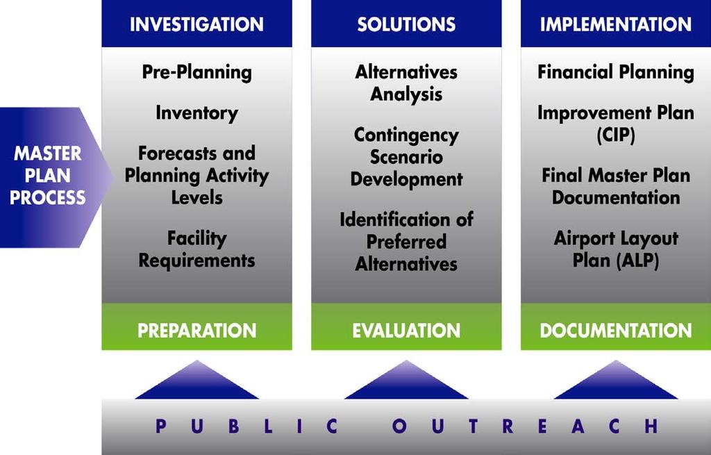

3


4 Multiplier Effect: Initial economic impacts from Airport enter economy and recirculate which generate successive rounds of employment, taxes, spending, and output. Paid Taxes $1.0 M Total Employment 243 Harvey Field Airport Business Regional Impact $14.9 M Visitor Spending Note: All impacts are shown in 2010 dollars $9.2 M


5 Harvey Field Funds Tie-down fees, land leases, fuel sales, nonaeronautical revenues, etc. FAA Grants Airport Improvement Program Airport Way, Runway, & Taxiway Improvements State of Washington Division of Aeronautics, State Infrastructure Bank, Fuel Tax FAA Grants provide 90% of the total cost of an eligible capital project FAA Airport Improvement Program grants come from Aviation Trust Fundfunded by aviation system user fees


6 Planning Advisory Committee Website Public Open Houses Government Briefings Focus Groups (Stakeholders) Pilot Group Business Group Noise Floodplain/Hydrology
7


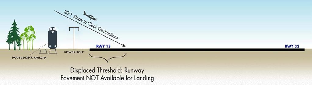
8 Current Runway Length, Width, & Orientation: 15L/33R - 2,671 feet x 36 feet Displaced Thresholds: Runway to south Runway to north A displaced threshold is a runway threshold located at a point other than the physical beginning or end of the runway. The portion of the runway so displaced may be used for takeoff but not for landing.
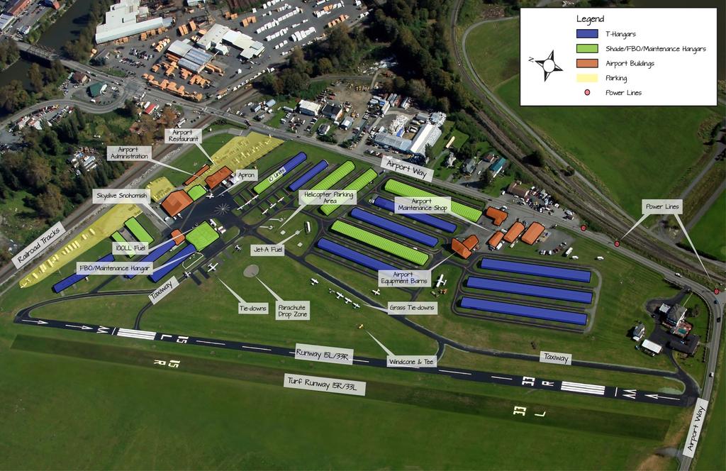
9


10 Runway 15L Railroad tracks Power Lines Trees Runway 33R Airport Way Power Lines Trees
11 Snohomish County Code (SCC) regarding Density Fringe have been a driving factor since we last met Priority has been to resolve safety issues of: Runway Displaced Thresholds Current 2671 runway provides useable runway length of 2219 for landing to the south and 2430 for landing to the north Full runway length is available for departures Airport Way Current roadway alignment is in the runway protection zone and FAA recognizes it as a safety concern
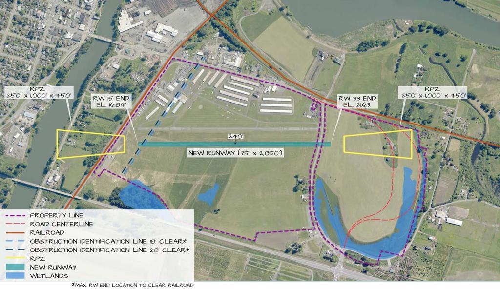
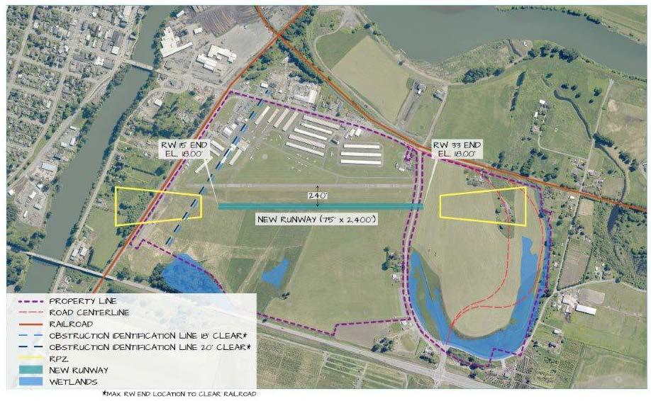
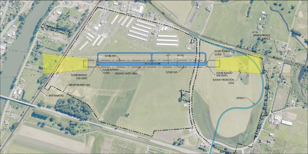
12 To meeting SCC regulations and meet FAA safety standards, our recommendation is a 2400 x 75 runway and a relocation of Airport Way This solution serves Harvey Field s existing aircraft fleet mix, improves aviation safety and improves roadway safety Now, how we got here and what it means.
13
14 Air Quality Coastal Resources Prior to the construction of any Compatible Land Uses improvement, projects must Construction Impacts undergo required local, state and/or Department of Transportation Act 4(f) federal environmental review and Farmlands approval processes Fish, Wildlife, and Plants Floodplains Hazardous Material, Pollution Prevention, and Solid Waste Historical, Architectural, Archaeological, and Cultural Resources Light Emissions and Visual Impacts Noise Secondary (Induced) Impacts Socioeconomic Impacts, Environmental Justice, and Children s Environmental Health and Safety Risks Wetlands Wild and Scenic Rivers
15

16 Storage Area #3 Storage Area #9 Storage Area #2


17 Long-standing procedures in place at Harvey Field Ongoing pilot education Noise Hotline , ext. 261 Information at
18
19
20 Local & FAA standards and regulations Planning and engineering standards Environmental and floodplain regulations


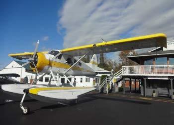
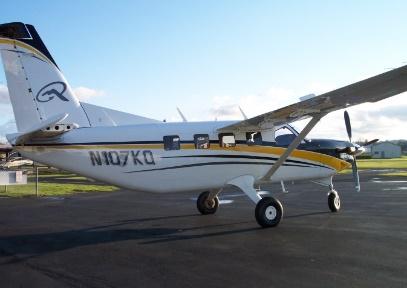


21 FREQUENT FLYERS AT S43 Cessna Caravan 208B DeHavilland DHC-2 Beaver DeHavilland Twin Otter (DHC-6) TBM 700 Quest Kodiak KingAir 200
22 Airport Way Road Improvement Build on Airport Property Build at safe distance from Runway Meet Density Fringe requirements Meet FEMA s requirement for base flood elevation (BFE) impact Meet Snohomish County Road Standards Improve substandard curves and shoulder widths Avoid wetlands Runway Serve same aircraft as now Build at safe distance from Airport Way Meet Density Fringe and FEMA BFE requirements Clear approaches over BNSF, Airport Way, and power lines

23 SAFETY & OPERATIONAL FACTORS Ability to safely accommodate future demand aircraft Safety for vehicles on Airport Way Evaluated based on anticipated improvements to address: Operational safety Capacity and delay Tenant convenience Ability to meet FAA design standards ENVIRONMENTAL FACTORS FAA Order E Potential physical impacts to surrounding community Ability to meet County planning and environmental standards ECONOMIC CONSIDERATIONS Historic infrastructure investment Remaining useful life of existing facilities Anticipated project costs Property acquisition requirements Cost-effectiveness evaluation Economic impact IMPLEMENTATION FEASIBILITY Tangible factors Practicality of implementation Intangible factors Community values Political environment
24 24 The maximum width (sum of widths) of all new construction, substantial improvements or other development shall not exceed 15 percent of the length of a line drawn perpendicular to the known floodwater flow direction at the point where the development(s) is located. The length of said line shall not extend beyond the property boundary or the edge of the density fringe area, whichever is less. The limitations of this section shall not apply to those uses listed in SCC o o o All of Harvey Field property is within the Density Fringe New construction is Fill anything that diverts or blocks Flood flows Sum of Fill widths / Total property width = 15% or less
25 25 Example: Flow Obstruction and Blockage Calculations Example from County Flood Permit Application: Determine the general floodplain flow direction Draw a line perpendicular to the flow direction Draw the line where it intersects the largest width of new construction as a percentage of property width. Sum of Fill widths/total property width must be less than 15% or fill in our case 900 property width 70 new obstruction width 70 /900 = 7.8% < 15 %


26 property width 571 new obstruction width 571 /4098 = 13.9% < 15 % Section A-A

27 property width 348 new obstruction width less 80 culvert opening areas from new obstruction width = = /1844 = 14.5% < 15% Section B-B
28 28 The land area occupied by any use or development permitted by this chapter located in the density fringe area that will displace floodwaters shall not exceed two percent of the land area of that portion of the lot. The limitations of this section shall not apply to those uses listed in SCC What does 2% mean with regard to Harvey Field? o o All of Harvey Field is within the Density Fringe so SCC applies everywhere 2% of (Harvey Field property) = acres


29 29 Green = Fill Area Red = Cut Area
30 30 The following uses shall be exempt from the maximum allowable density and obstruction limitations of SCC and : (1) Water-dependent utilities; (2) Dikes; (3) Utility facilities; and (4) Public Works, when the project proponent demonstrates that the floodwater displacement effects of the proposal when considered together with the maximum potential floodwater displacement allowed by SCC and shall not cause a cumulative increase in the base flood elevation of more than one foot. Snohomish County confirmed Public Works includes Airport Way as a public road
31 31...demonstrates that the floodwater displacement effects of the proposal when considered together with the maximum potential floodwater displacement allowed by SCC and o Base Flood = the 100-year flood elevation, as shown on the current FEMA Flood Insurance Rate Maps (FIRMs) o Floodwater displacement means that for every piece of material placed in construction of the road will take up some space that was previously available for water storage or conveyance during a flood. o Road relocation floodwater displacement calculation assumes that the maximum 2% area and 15% blockages will eventually occur on all properties located in the floodplain. o WEST Consultants ran the same model including all of the proposed improvements (Runway, Taxiway, and Airport Way). o SCC only requires BFE modeling for Public Works projects, i.e. Airport Way. o Our approach included road, runway, and taxiway improvements. o The model shows an 0.00 rise in the base flood elevation.
32

33
34
35
36
37
38
39
40 AND HANAGRS
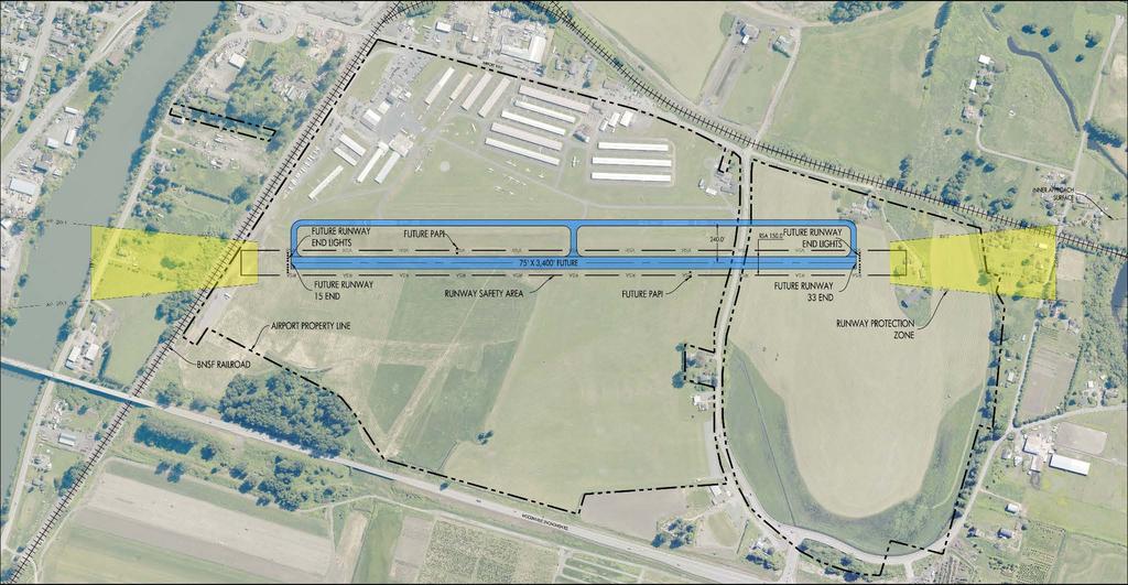
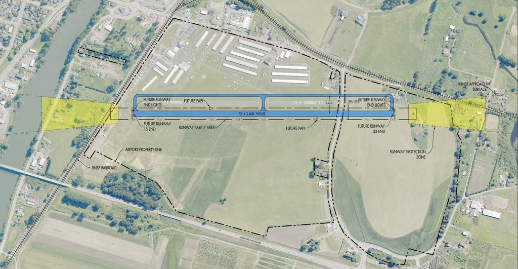
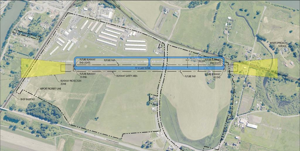
41 Option No Action Alternative 1: New 3,400-ft Rwy & Use Existing Rwy as Twy Alternative 2: New 3,400-ft Rwy & New Twy Alternative 3: New 3,400-ft Rwy & Move Airport Way South Alternative 4: New 2,400-ft Rwy & Move Airport Way South Description Existing runway remains Advantages No cost Meets density fringe requirements Disadvantages Feasibility Does not meet key FAA runway design standards (displaced threshold on both ends, obstructions) Displaced thresholds remain New 3,400-ft Rwy 15/ west of existing Rwy15L/33R Meets runway length requirements for design category fleet Re-uses existing runway as parallel taxiway Exceeds SCC limits for fill in Density Fringe. Unlikely to receive permits from Snohomish County. New 3,400-ft Rwy 15/ west of existing partial parallel twy Meets runway length requirements for design category fleet Exceeds SSC limits for fill in Density Fringe Unlikely to receive permits from Snohomish County New 3,400-ft Rwy 15/ south of BNSF & relocated Airport Way Meets runway length requirements for design category fleet Exceeds SCC limits for fill in Density Fringe Does not allow for relocated Airport Way on County ROW/Harvey property Unlikely to receive permits from Snohomish County. New 2,400-ft Rwy 15/33 & relocated Airport Way Meets runway length requirements for existing and forecast aircraft Meets FAA design standards Meets SCC Density Fringe requirements Flood water storage capacity impact less than Flow blockage less than 15% limit. * Does not re-use existing runway pavement as parallel taxiway SCC Density Fringe Fill permit feasible

42 Alternative 4 (2,400 Runway) with Option 1 for Airport Way South Airport Way Build on Airport Property Build at safe distance from Runway Meet Density Fringe requirements Meet Snohomish County Road Standards Improve substandard curves and shoulder widths Minimizes wetlands impact Runway Serve same aircraft as now Build at safe distance from Airport Way Meet Density Fringe requirements Clear approach over BNSF and Airport Way Shorter runway with safety areas
43 Current Runway Length, Width, & Orientation 15L/33R - 2,671 feet x 36 feet Displaced Thresholds: Runway to south Runway to north Recommended Alternative 4: Runway Length, Width, & Orientation 15L/33R - 2,400 feet x 75 feet Clear approaches


44 Per FAA guidance, residences within the 65 dnl are eligible for noise mitigation Abatement procedures for south departures will be evaluated by Airport management and the Noise Abatement Committee
45


46 Complete Implementation Plan Finalize Airport Layout Plan Submit documentation for County and FAA approval process


47 Chapters are on website (
48 Cynthia Hendrickson Airport Manager x229 Renee Dowlin Project Manager Kandace Harvey Owner x224
Airport Master Plan Update June 15, 2017
 Airport Master Plan Update June 15, 2017 www.harveyfield.com The Master Plan is a 20-year plan to understand the needs of current and future users of the Airport. This is important to ensure that safe
Update on the Aspen/Pitkin County Airport Improvements
 Update on the Aspen/Pitkin County Airport Improvements and EA Process Public Information Meeting September 10, 2015 Meeting Objectives Explain what has changed since we had our last meeting and how it
I-3 DFW Extension Public Hearing. June 2, 2011
 1 I-3 DFW Extension Public Hearing June 2, 2011 2 DFW LRT Extension Agenda: Introductions Service Plan Amendment Alignment, Grade Separations, Station, Yard Environmental Assessment Environmental Impacts/Mitigation
CatExes vs. EAs When and How to Prepare
 CatExes vs. EAs When and How to Prepare Panel: Steve Culberson, Ricondo & Associates Frank Smigelski, FAA Mary Vigilante, Synergy Tuesday December 10, 2013 Washington, DC 1 So you have a project Do I have
DRAFT FINAL REPORT AIRPORT MASTER PLAN. Rifle Garfield County Airport Revised May 15, 2014
 DRAFT FINAL REPORT AIRPORT MASTER PLAN Rifle Garfield County Airport Revised May 15, 2014 As required by Paragraph 425.B(4) of FAA Order 5100.38C, Airport Improvement Program (AIP) Handbook: The preparation
1.0 Project Background Mission Statement and Goals Objectives of this Sustainable Master Plan
 TABLE OF CONTENTS CHAPTER 1 INTRODUCTION 10 Project Background 1-1 11 Mission Statement and Goals 1-1 12 Objectives of this Sustainable Master Plan 1-2 CHAPTER 2 INVENTORY 20 Airport Background 2-1 201
ERIE INTERNATIONAL AIRPORT MASTER PLAN TABLE OF CONTENTS
 EXECUTIVE SUMMARY ERIE INTERNATIONAL AIRPORT MASTER PLAN TABLE OF CONTENTS PAGE NO. CHAPTER 1-INTRODUCTION... 1-1 1.01 General...1-1 1.02 Purpose and Scope of Study...1-1 1.03 The Planning Process...1-2
FACILITY REQUIREMENTS SUMMARY OF KEY ISSUES OVERVIEW
 FACILITY REQUIREMENTS SUMMARY OF KEY ISSUES OVERVIEW This summary is intended to provide a brief overview of the key issues associated with conformance to FAA standards at Methow Valley State Airport.
Chapter 4.0 Alternatives Analysis
 Chapter 4.0 Alternatives Analysis Chapter 1 accumulated the baseline of existing airport data, Chapter 2 presented the outlook for the future in terms of operational activity, Chapter 3 defined the facilities
The San Diego Region s Air Transportation Future
 The San Diego Region s Air Transportation Future June 22, 2006 1 Ryan N. Hall, Airport System Planner II San Diego County Regional Airport Authority Presentation Overview 1. The law 2. The ballot measure
CHAPTER 1 EXECUTIVE SUMMARY
 CHAPTER 1 EXECUTIVE SUMMARY 1 1 EXECUTIVE SUMMARY INTRODUCTION William R. Fairchild International Airport (CLM) is located approximately three miles west of the city of Port Angeles, Washington. The airport
AIRPORT MASTER PLAN. Newport State Airport. Draft. (Colonel Robert F. Wood Airpark) THE Louis Berger Group, INC. Prepared for: Prepared by:
 THE Louis Berger Group, INC. Prepared for: Prepared by:") Draft AIRPORT MASTER PLAN Newport State Airport () Prepared for: 2000 Post Road Warwick, Rhode Island 02886-1533 THE Louis Berger Group, INC. 20 Corporate Woods Boulevard Albany, New York 12211-2370 Prepared
Draft AIRPORT MASTER PLAN Newport State Airport () Prepared for: 2000 Post Road Warwick, Rhode Island 02886-1533 THE Louis Berger Group, INC. 20 Corporate Woods Boulevard Albany, New York 12211-2370 Prepared
Airport Master Plan Update
 Duttchessss Countty Airrporrtt Masstterr Plan Updatte Airport Master Plan Update Final Report Dutchess County Airport Town of Wappingers, New York C&S Engineers, Inc. 499 Col. Eileen Collins Blvd. Syracuse,
Airport Master Plan Open House Front Range Airport February 23, 2017
 Airport Master Plan Open House Front Range Airport February 23, 2017 MASTER PLAN PROCESS AND OVERVIEW MASTER PLAN ELEMENTS The Master Plan is a 20-year plan to understand the needs of current and future
Merritt Island Airport
 TABLE OF CONTENTS CHAPTER 1 INTRODUCTION... 1-1 INTRODUCTION AND PROJECT OVERVIEW... 1-1 General Guidelines... 1-1 Prior Planning Documentation... 1-2 Key Issues... 1-2 Goals and Objectives... 1-2 Regulatory
Why are the underground fuel tanks being removed and replaced with above ground tanks?
 AIRPORT/CITIZEN FAQ This list of Frequently Asked Questions (FAQs) with responses are provided to share information related to airport topics with the Citizens of Georgetown. The questions / responses
Draft Concept Alternatives Analysis for the Inaugural Airport Program September 2005
 Section 10 Preferred Inaugural Airport Concept 10.0 Introduction The Preferred Inaugural Airport Concept for SSA was developed by adding the preferred support/ancillary facilities selected in Section 9
FAA RECORD OF DECISION. Appendix D FINAL EIS ADDENDUM DOCUMENTS
 FORT LAUDERDALE-HOLLYWOOD INTERNATIONAL AIRPORT FAA RECORD OF DECISION Appendix D FINAL EIS ADDENDUM DOCUMENTS This appendix contains information that has been identified as having been inadvertently omitted
PUBLIC SCOPING MEETING APRIL 2018
 Photo credit: Patrick Schneider PUBLIC SCOPING MEETING APRIL 2018 Welcome to the meeting! The Federal Aviation Administration (FAA) is preparing an Environmental Impact Statement (EIS) to evaluate the
STAFF REPORT. Airport Land Use Plan Consistency Review: Santa Barbara Airport Master Plan. MEETING DATE: November 19, 2015 AGENDA ITEM: 7D
 STAFF REPORT SUBJECT: Airport Land Use Plan Consistency Review: Santa Barbara Airport Master Plan MEETING DATE: AGENDA ITEM: 7D STAFF CONTACT: Peter Imhof, Andrew Orfila RECOMMENDATION: Adopt findings
CHAPTER 1: INTRODUCTION
 CHAPTER 1: INTRODUCTION Purpose and Scope The information presented in this report represents the study findings for the 2016 Ronan Airport Master Plan prepared for the City of Ronan and Lake County, the
Pilot Focus Group. March 31, :30 AM 10:00 AM. Meeting Minutes
 Pilot Focus Group March 31, 2015 8:30 AM 10:00 AM Meeting Minutes Attendees: Dennis Butterfield, Harvey Field/Based Pilot Terry Chamberlain, Harvey Field/Based Pilot Melanie Hancock, Snohomish Flying/Based
CHAPTER 3 ALTERNATIVES CONSIDERED
 CHAPTER 3 ALTERNATIVES CONSIDERED 3.0 ALTERNATIVES The 2010 Stevensville Airport Master Plan contained five (5) airside development options designed to meet projected demands. Each of the options from
Table of Contents. Master Plan March 2014 TOC i Spokane International Airport
 Table of Contents Page Chapter 1 Inventory 1. Introduction... 1 1 1.1 Community Profile... 1 2 1.1.1 Location and Setting... 1 1 1.1.2 Climate... 1 2 1.1.3 Socioeconomic Conditions... 1 5 1.1.4 Area Land
Austin-Bergstrom International Airport Master Plan Update
 FINAL REPORT Prepared for: City of Austin Department of Aviation 3600 Presidential Boulevard Austin, Texas 78719 Prepared by: P&D Aviation A Division of P&D Consultants, Inc. 999 Town & County Road, 4
TABLE OF CONTENTS. Washington Aviation System Plan Update July 2017 i
 TABLE OF CONTENTS Chapter 1 Overview... 1-1 1.1 Background... 1-1 1.2 Overview of 2015 WASP... 1-1 1.2.1 Aviation System Performance... 1-2 1.3 Prior WSDOT Aviation Planning Studies... 1-3 1.3.1 2009 Long-Term
Kittitas County Airport Bowers Field Airport Master Plan Planning Advisory Committee Meeting #1 April 6, 2016
 Kittitas County Airport Bowers Field Airport Master Plan Planning Advisory Committee Meeting #1 April 6, 2016 Project Team Kittitas County, WA Airport Owner (Sponsor) and Operator, Land Use Century West
Airport Master Plan for Montgomery-Gibbs Executive Airport PAC Meeting #3
 Airport Master Plan for Montgomery-Gibbs Executive Airport PAC Meeting #3 Agenda > Introductions > Public Meetings Overview > Working Paper 3 - Facility Requirements > Working Paper 4 - Environmental Baseline
Appendix D Project Newsletters. Tacoma Narrows Airport. Master Plan Update
 Appendix D Project Newsletters Tacoma Narrows Airport Master Plan Update This appendix contains the newsletters distributed throughout the project. These newsletters provided updates and information on
Executive Summary. MASTER PLAN UPDATE Fort Collins-Loveland Municipal Airport
 Executive Summary MASTER PLAN UPDATE Fort Collins-Loveland Municipal Airport As a general aviation and commercial service airport, Fort Collins- Loveland Municipal Airport serves as an important niche
Prepared By: Mead & Hunt, Inc Port Lansing Road Lansing, MI 48906
 Master Plan The preparation of this document was financed in part through a planning grant from the Federal Aviation Administration (FAA) as provided under Section 505 of the Airport and Airway Improvement
Hartford-Brainard Airport Potential Runway Closure White Paper
 Hartford-Brainard Airport Potential Runway 11-29 Closure White Paper June 2012 In recent years there has been discussion regarding the necessity of Runway 11-29 to the Hartford- Brainard Airport (HFD)
Westover Metropolitan Airport Master Plan Update
 Westover Metropolitan Airport Master Plan Update June 2008 INTRODUCTION Westover Metropolitan Airport (CEF) comprises the civilian portion of a joint-use facility located in Chicopee, Massachusetts. The
ACTION TRANSMITTAL
 Transportation Advisory Board of the Metropolitan Council of the Twin Cities ACTION TRANSMITTAL 2018-16 DATE: February 9, 2018 TO: Transportation Advisory Board FROM: Technical Advisory Committee PREPARED
Lake Tahoe Airport Master Plan Public Meeting March 16, 2015
 Lake Tahoe Airport Master Plan Public Meeting March 16, 2015 What is an Airport Master Plan? a comprehensive study of an airport [that] usually describes the short, medium, and long term development plans
AIRPORT COMPLIANCE th Texas Aviation Conference. 3/29/2018 Date. Footer Text
 AIRPORT COMPLIANCE 2018 36 th Texas Aviation Conference 3/29/2018 AWOS FCC LICENSE RENEWAL Needs renewal every 10 years (renew 90 days before expiration). Needs update if there is name change, coordinate
Aviation, Rail, & Trucking 6-1
 6-1 This chapter describes the services, facilities, and condition of air, rail, and trucking as components of the transportation system. These three intermodal areas have an impact on the factors to be
Preferred Alternative Summary
 Tacoma Narrows Airport Master Plan Update Preferred Alternative Summary The Preferred Alternative represents Pierce County s vision for the long-term development of the Tacoma Narrows Airport. This Alternative
Airport Master Plan. Brookings Regional Airport. Runway Runway 17-35
 Runway 17-35 Airport Master Plan Runway 12-30 Brookings Regional Airport Table of Contents Table of Contents Chapter 1: Master Plan Goals... 1-1 1.1. Introduction... 1 1.2. Objective 1 Identify improvements
Yakima Air Terminal/McAllister Field Airport Master Plan Update
 Yakima Air Terminal/McAllister Field Airport Master Plan Update City of Yakima Work Session July 9, 2013 Meeting Goals Summarize the master plan recommendations. Discuss the decision-making process used
Preliminary Findings of Proposed Alternative
 Preliminary Findings of Proposed Alternative The attached drawing provides a schematic layout of the proposed alternative that will be discussed on July 27, 2010. A full report will follow and should be
Table of Contents. Overview Objectives Key Issues Process...1-3
 Table of Contents Chapter One Introduction Overview...1-1 Objectives...1-1 Key Issues...1-2 Process...1-3 Chapter Two Inventory of Existing Conditions Airport Setting...2-1 Locale...2-1 Airport Surroundings...2-5
Input Efforts Online survey of tenants and users Focus group meetings with Tenants and users Agencies and stakeholders General Aviation Pilot
 Input Efforts Online survey of tenants and users Focus group meetings with Tenants and users Agencies and stakeholders General Aviation Pilot community Airport Advisory Board meetings Elected Officials
Harvey Field Airport. Planning Advisory Committee & Public Open House. April 1, Comment Responses
 Harvey Field Airport Planning Advisory Committee & Public Open House April 1, 2015 Comment Responses In an effort to respond to comments received at both the Planning Advisory Committee (PAC) meeting and
FORT LAUDERDALE-HOLLYWOOD INTERNATIONAL AIRPORT ENVIRONMENTAL IMPACT STATEMENT DRAFT
 D.3 RUNWAY LENGTH ANALYSIS Appendix D Purpose and Need THIS PAGE INTENTIONALLY LEFT BLANK Appendix D Purpose and Need APPENDIX D.3 AIRFIELD GEOMETRIC REQUIREMENTS This information provided in this appendix
Airport Master Plan for. Brown Field Municipal Airport PAC Meeting #3
 Airport Master Plan for Brown Field Municipal Airport PAC Meeting #3 Public Meeting #1 > 8/24/17 from 5:30 to 8:00 pm > 41 attendees signed-in > Comments: > EAA area > Environmental constraints > Focus
Chapter 8.0 Implementation Plan
 Chapter 8.0 Implementation Plan 8.1 Introduction This chapter is the culmination of the analytical work accomplished in the previous chapters. The result is a prioritized list of the essential projects.
Lake Tahoe Airport Master Plan
 Lake Tahoe Airport Master Plan City Council Briefing October 20, 2015 What is an Airport Master Plan? a comprehensive study of an airport [that] usually describes the short, medium, and long term development
CHAPTER FOUR AIRPORT ALTERNATIVES
 4.0 INTRODUCTION CHAPTER FOUR The goal of the master planning process is to provide the City of New Smyrna Beach with an assessment of the adequacy and capabilities of the Airport as well as to identify
Chapter 1 Introduction and Project Overview
 EPHRATA MUNICIPAL AIRPORT Chapter 1 Introduction and Project Overview The Port of Ephrata in cooperation with the Federal Aviation Administration (FAA) is updating the Airport Master Plan for Ephrata Municipal
Punta Gorda Airport Master Plan Update
 Punta Gorda Airport Master Plan Update Draft Executive Summary Prepared for: The Charlotte County Airport Authority January 2018 Charlotte County Airport Authority James Herston, Chair Robert D. Hancik,
SECTION 5 ALTERNATIVE DEVELOPMENT CONCEPT ANALYSES
 SECTION 5 ALTERNATIVE DEVELOPMENT CONCEPT ANALYSES 5.1 INTRODUCTION This section investigates Airfield Development Alternatives, generalized Land Use Alternatives, and more detailed General Aviation Alternatives.
JOSLIN FIELD, MAGIC VALLEY REGIONAL AIRPORT DECEMBER 2012
 1. Introduction The Federal Aviation Administration (FAA) recommends that airport master plans be updated every 5 years or as necessary to keep them current. The Master Plan for Joslin Field, Magic Valley
Draft Concept Alternatives Analysis for the Inaugural Airport Program September 2005
 Draft Concept Alternatives Analysis for the Inaugural Airport Program September 2005 Section 3 - Refinement of the Ultimate Airfield Concept Using the Base Concept identified in Section 2, IDOT re-examined
General Dick Stout Field: 2010 General Aviation Airport Runway 18/36 3,410 x Hangars 65 Based Aircraft St. George 177 Based A/C Cedar d City 65
 the Future of GENERAL DICK STOUT FIELD Hurricane, Utah December 16, 2010 General Dick Stout Field: 2010 General Aviation Airport Runway 18/36 3,410 x 40 43 Hangars 65 Based Aircraft St. George 177 Based
Norfolk International Airport
 Norfolk International Airport Master Plan Update Technical Advisory Committee Meeting #1 Community Advisory Committee Meeting #1 January 24, 2018 Agenda Project Background Introductions Overview of Airport
Chapter Seven COST ESTIMATES AND FUNDING A. GENERAL
 Chapter Seven COST ESTIMATES AND FUNDING A. GENERAL This chapter delineates the recommended 2005 2024 Sussex County Airport Capital Improvement Program (CIP). It further identifies probable construction
2015 PURDUE ROAD SCHOOL March 11, 2015
 2015 PURDUE ROAD SCHOOL March 11, 2015 Runway Protection Zone (RPZ) Definition It is a trapezoidal shape formed off the end of a runway and its geometry it a function of the airport s aircraft approach
Appendix C AIRPORT LAYOUT PLANS
 Appendix C AIRPORT LAYOUT PLANS Appendix C AIRPORT LAYOUT PLANS Airport Master Plan Santa Barbara Airport As part of this Airport Master Plan, the Federal Aviation Administration (FAA) requires the development
Addendum - Airport Development Alternatives (Chapter 6)
") Bowers Field Addendum - Airport Development Alternatives (Chapter 6) This addendum to the Airport Development Alternatives chapter includes the preferred airside development alternative and the preliminary
Bowers Field Addendum - Airport Development Alternatives (Chapter 6) This addendum to the Airport Development Alternatives chapter includes the preferred airside development alternative and the preliminary
Safety, Infrastructure, and Tenant Improvement Project. Public Hearing Informational Brochure February 26, 2013
 New York State Department of Transportation Safety, Infrastructure, and Tenant Improvement Project Public Hearing Informational Brochure February 26, 2013 This DEIS/Draft EA evaluates the potential impacts
MONTEREY REGIONAL AIRPORT MASTER PLAN TOPICAL QUESTIONS FROM THE PLANNING ADVISORY COMMITTEE AND TOPICAL RESPONSES
 MONTEREY REGIONAL AIRPORT MASTER PLAN TOPICAL QUESTIONS FROM THE PLANNING ADVISORY COMMITTEE AND TOPICAL RESPONSES Recurring topics emerged in some of the comments and questions raised by members of the
6.0 Capital Improvement Program. 6.1 Capital Improvement Plan (CIP)
") 6.0 The addresses the phased scheduling of projects identified in this Master Plan and their financial implications on the resources of the Airport and the City of Prescott. The phased Capital Improvement
6.0 The addresses the phased scheduling of projects identified in this Master Plan and their financial implications on the resources of the Airport and the City of Prescott. The phased Capital Improvement
According to FAA Advisory Circular 150/5060-5, Airport Capacity and Delay, the elements that affect airfield capacity include:
 4.1 INTRODUCTION The previous chapters have described the existing facilities and provided planning guidelines as well as a forecast of demand for aviation activity at North Perry Airport. The demand/capacity
The following criteria shall be applied within the boundaries of the AO District:
 Sec. 419 (a) Purpose AIRPORT OVERLAY DISTRICT (AO) The purpose of the Airport Overlay District is to regulate and restrict the height of structures, objects, or natural growth, regulate the locations of
Airport Master Plan 1
 1 Aviation Demand AIRPORT PLANNING PROCESS FAA Design Standards Financial Resources Community Goals Environmental Requirements Serve Business Community This Advisory Circular (AC) provides guidance for
DRAFT MASTER PLAN UPDATE
 DRAFT MASTER PLAN UPDATE CHAPTER VI: AIRPORT LAYOUT PLAN NARRATIVE DRAFT REPORT APRIL 2017 PREPARED BY: Table of Contents WESTCHESTER COUNTY AIRPORT 6 AIRPORT LAYOUT PLAN NARRATIVE REPORT... 6-1 6.1 AGIS
FORECASTING FUTURE ACTIVITY
 EXECUTIVE SUMMARY The Eagle County Regional Airport (EGE) is known as a gateway into the heart of the Colorado Rocky Mountains, providing access to some of the nation s top ski resort towns (Vail, Beaver
2009 Muskoka Airport Economic Impact Study
 2009 Muskoka Airport Economic Impact Study November 4, 2009 Prepared by The District of Muskoka Planning and Economic Development Department BACKGROUND The Muskoka Airport is situated at the north end
Chapter 2 FINDINGS & CONCLUSIONS
 Chapter 2 FINDINGS & CONCLUSIONS 2.01 GENERAL Dutchess County acquired the airport facility in 1947 by deed from the War Assets Administration. Following the acquisition, several individuals who pursued
Office of Commercial Space Transportation: Notice of Availability, Notice of Public
 This document is scheduled to be published in the Federal Register on 04/20/2018 and available online at https://federalregister.gov/d/2018-08345, and on FDsys.gov [4910-13] DEPARTMENT OF TRANSPORTATION
6.1 INTRODUCTION 6.2 AIRSIDE ALTERNATIVES NORTH PERRY AIRPORT MASTER PLAN UPDATE RUNWAY LENGTH REQUIREMENTS SECTION 6: ALTERNATIVES ANALYSIS
 6.1 INTRODUCTION In the previous chapter, facility needs for the 20-year planning horizon were identified. The next step in the planning process is to identify and evaluate the various ways certain facilities
RSAT RUNUP ANALYSIS 1. INTRODUCTION 2. METHODOLOGY
 RSAT RUNUP ANALYSIS 1. INTRODUCTION The FAA Runway Safety Action Team (RSAT) is a team of FAA staff that works with airports to address existing and potential runway safety problems and issues. The RSAT
Thursday, May 2 nd, 2013 South St. Paul Municipal Airport Meeting Room 4:00 p.m. 5:30 p.m. MEETING NOTES
 SOUTH ST. PAUL MUNICIPAL AIRPORT FLEMING FIELD MASTER PLAN ADVISORY GROUP MEETING #2 Thursday, May 2 nd, 2013 South St. Paul Municipal Airport Meeting Room 4:00 p.m. 5:30 p.m. MEETING NOTES The purpose
STUDY OVERVIEW MASTER PLAN GOALS AND OBJECTIVES
 INTRODUCTION An Airport Master Plan provides an evalua on of the airport s avia on demand and an overview of the systema c airport development that will best meet those demands. The Master Plan establishes
PLU Airport Master Plan Master Plan Advisory Committee (MPAC) Meeting #4 MASTER PLAN ADVISORY COMMITTEE (MPAC) - MEETING #4
 Meeting #4 MASTER PLAN ADVISORY COMMITTEE (MPAC) - MEETING #4") MASTER PLAN ADVISORY COMMITTEE (MPAC) - MEETING #4 MASTER PLAN ADVISORY COMMITTEE (MPAC) MEETING #4 AGENDA & ACTION ITEMS Date/Time: Location: Monday, March 19, 2018 from 1:30-3:30 p.m. Thun Field Airport
MASTER PLAN ADVISORY COMMITTEE (MPAC) - MEETING #4 MASTER PLAN ADVISORY COMMITTEE (MPAC) MEETING #4 AGENDA & ACTION ITEMS Date/Time: Location: Monday, March 19, 2018 from 1:30-3:30 p.m. Thun Field Airport
B GEORGIA INFRASTRUCTURE REPORT CARD AVIATION RECOMMENDATIONS DEFINITION OF THE ISSUE. Plan and Fund for the Future:
 2014 GEORGIA INFRASTRUCTURE REPORT CARD B + RECOMMENDATIONS Plan and Fund for the Future: While the system continues to enjoy excess capacity and increased accessibility it still needs continued focus
PULLMAN-MOSCOW REGIONAL AIRPORT Runway Realignment Project
 PULLMAN-MOSCOW REGIONAL AIRPORT Runway Realignment Project GENERAL AIRPORT INFORMATION AIRPORT USERS Airport ownership: Public, owned by the Pullman-Moscow Regional Airport Board Year opened: February
Table of Contents. List of Tables. Cincinnati/Northern Kentucky International Airport 2035 Master Plan Update
 Table of Contents 7.1. Airport Layout Plan (Existing Conditions)... 2 7.2. Airport Layout Plan (Future Conditions)... 3 7.3. Technical Data Sheet... 5 7.4. Commercial Terminal Area Drawing... 5 7.5. East
Las Vegas McCarran International Airport. Capacity Enhancement Plan
 Las Vegas McCarran International Airport Capacity Enhancement Plan Las Vegas McCarran International Airport Capacity Enhancement Plan September 1994 Prepared jointly by the U.S. Department of Transportation,
BNA Master Plan Update Community Advisory Committee Meeting No. 5
 A Six Sigma Organization BNA Master Plan Update Community Advisory Committee Meeting No. 5 September 19, 2012 Introductions MNAA Staff RW Armstrong Team Albersman & Armstrong, Ltd. Atkins North America,
AIRPORT MASTER PLAN FOR. charles B. WHEELER DOWNTOWN AIRPORT KANSAS CITY, MISSOURI
 AIRPORT MASTER PLAN FOR charles B. WHEELER DOWNTOWN AIRPORT KANSAS CITY, MISSOURI Prepared For The City of Kansas City, Missouri By Coffman Associates, Inc. January 2004 "The contents of these documents
Massport Study Team Evaluation of CAC Noise Study Alternatives. October 2010
 Massport Study Team Evaluation of CAC Noise Study Alternatives October 2010 Massport s Evaluation Team Aviation Planning Capital Programs Aviation Operations Environmental Permitting Consultation with
Summary of Committee Discussion/Questions Metropolitan Transportation Services Senior Planner Russ Owen presented this item.
 Committee Report Business Item No. 2017-191 Transportation Committee For the Metropolitan Council meeting of September 13, 2017 Subject: Final Crystal Airport 2035 Long Term Comprehensive Plan (LTCP) Proposed
RULES OF TENNESSEE DEPARTMENT OF TRANSPORTATION AERONAUTICS DIVISION CHAPTER LICENSING AND REGISTRATION OF AIRPORTS TABLE OF CONTENTS
 RULES OF TENNESSEE DEPARTMENT OF TRANSPORTATION AERONAUTICS DIVISION CHAPTER 1680-1-2 LICENSING AND REGISTRATION OF AIRPORTS TABLE OF CONTENTS 1680-1-2-.01 Purpose 1680-1-2-.06 Repealed 1680-1-2-.02 Definitions
Airport Obstruction Standards
 Airport Obstruction Standards Dr. Antonio Trani Department of Civil and Environmental Engineering Virginia Tech Outline of this Presentation Obstructions to navigation around airports Discussion of Federal
AIRPORT MASTER PLAN UPDATE
 AIRPORT MASTER PLAN UPDATE PENSACOLA INTERNATIONAL AIRPORT Technical Advisory Committee Meeting #2 June 20, 2017 Agenda» Introduction» Facility Requirements Airside Terminal Landside General Aviation Cargo
PUBLIC MEETING 2. Airport Master Plan Update. March 2019
 PUBLIC MEETING 2 Airport Master Plan Update March 2019 Airport Overview MASTER PLAN MISSION: How do we modernize the airport to enhance the student experience, aerospace research & the central Ohio region?
5.0 ALTERNATIVES ANALYSIS
 5.0 ALTERNATIVES ANALYSIS The Alternative Analysis chapter describes and evaluates the various development alternatives considered for. In addition, it presents a preferred development plan that accommodates
Chapter 1 Introduction and Project Overview
 Chapter 1 Introduction and Project Overview Kittitas County in cooperation with the Federal Aviation Administration (FAA) is updating the Airport Master Plan for Bowers Field Airport (FAA airport identifier
Pierre Regional Airport Airport Master Plan. Kickoff Meeting April 7, 2017
 Pierre Regional Airport Airport Master Plan Kickoff Meeting April 7, 2017 Agenda Introductions Airport Master Planning Planning Considerations Master Plan Elements Schedule Public Involvement Basics about
New Opportunities PUBLIC WORKSHOP. Venice Municipal. Bringing g the pieces together
 Bringing g the PUBLIC WORKSHOP Venice Municipal Airport New Opportunities Presented for Venice City Council & Citizens of Venice September 25, 2009 Slide 1 Bringing g the Welcome & Introductions May 12th
Chapter Six ALP Drawings. Tacoma Narrows Airport. Master Plan Update
 Chapter Six ALP Drawings Master Plan Update The master planning process for the (Airport) has evolved through efforts in the previous chapters to analyze future aviation demand, establish airside and landside
FRENCH VALLEY AIRPORT (F70) Sky Canyon Dr. Murrieta, CA. Phone: Riverside FAA FSDO Complaint Line: (951)
 Sky Canyon Dr. Murrieta, CA. Phone: Riverside FAA FSDO Complaint Line: (951)") FRENCH VALLEY AIRPORT (F70) 37600 Sky Canyon Dr. Murrieta, CA Phone: 951-600-7297 Riverside FAA FSDO Complaint Line: (951) 276-6701 Visit the F70 website for additional information regarding the airport
FRENCH VALLEY AIRPORT (F70) 37600 Sky Canyon Dr. Murrieta, CA Phone: 951-600-7297 Riverside FAA FSDO Complaint Line: (951) 276-6701 Visit the F70 website for additional information regarding the airport
Agenda: SASP SAC Meeting 3
 Agenda: SASP SAC Meeting 3 Date: 04/12/18 Public Involvement Plan Update Defining the System Recommended Classifications Discussion Break Review current system Outreach what we heard Proposed changes Classification
PROPOSED HORIZONTAL LAYOUT FILLET DESIGN FOR ENTRANCE/EXIT TAXIWAYS
 PROPOSED HORIZONTAL LAYOUT FILLET DESIGN FOR ENTRANCE/EXIT TAXIWAYS INTRODUCTION The Zelienople Airport Authority (ZAA) has commenced engineering activities for the rehabilitation of Runway 17-35 to a
Reliever Airports: NOISE ABATEMENT PLAN Flying Cloud Airport (FCM)
") Reliever Airports: NOISE ABATEMENT PLAN Flying Cloud Airport (FCM) INTRODUCTION The Noise Abatement Plan (FCM Plan) for the Flying Cloud Airport has been prepared in recognition of the need to make the
Reliever Airports: NOISE ABATEMENT PLAN Flying Cloud Airport (FCM) INTRODUCTION The Noise Abatement Plan (FCM Plan) for the Flying Cloud Airport has been prepared in recognition of the need to make the
Airport Master Plan. Rapid City Regional Airport. October 2015 FAA Submittal
 Airport Master Plan Rapid City Regional Airport October 2015 FAA Submittal Rapid City Regional Airport Master Plan Update Table of Contents Executive Summary... i Scope & Timeline... i Forecasts... i Preferred
EXHIBIT A. LOMPOC AIRPORT MASTER PLAN SCOPE OF WORK AIP Project #
 EXHIBIT A LOMPOC AIRPORT MASTER PLAN SCOPE OF WORK AIP Project # 3-06-0125-11 INTRODUCTION The following proposed work program for the Lompoc Airport Master Plan describes in detail the work which is to
Finance and Implementation
 5 Finance and Implementation IMPLEMENTATION The previous chapters have presented discussions and plans for development of the airfield, terminal, and building areas at Sonoma County Airport. This chapter