ASSESSMENT OF MULTI-USE TRAIL ACCOMMODATION
|
|
|
- Milo Bruce
- 5 years ago
- Views:
Transcription

1 ASSESSMENT OF MULTI-USE TRAIL ACCOMMODATION WEKIVA PARKWAY (SR 429)/SR 46 REALIGNMENT PD&E STUDY Orange, Lake, and Seminole Counties, Florida Financial Project ID: and Federal Aid Project Number: TBD Prepared for Orlando-Orange County Expressway Authority and Florida Department of Transportation, District Five Prepared by October 2008
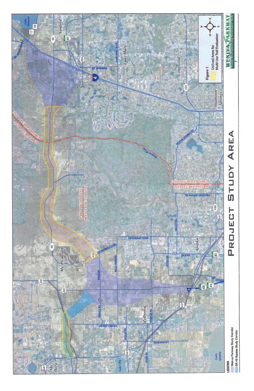
2 Table of Contents 1.0 Background.Page Meetings with Trail Stakeholders..Page Trail Assessment and Concepts Page Conclusions.Page 1 Figure 1. Defined Areas for Multi-Use Trail Evaluation...Page 2 Appendix A Meeting Agendas, Sign-In Sheets, and Trail Stakeholders Contact List Appendix B Trail Assessment for the Wekiva Parkway/SR 46 Realignment PD&E Study and Conceptual Trail Alignments in Orange, Lake and Seminole Counties Appendix C Comments from Trail Stakeholders i WEKIVA PARKWAY/SR 46 REALIGNMENT PD&E STUDY ASSESSMENT OF MULTI-USE TRAIL ACCOMMODATION OCTOBER, 2008
3 1.0 Background As part of the Wekiva Parkway (SR 429)/SR 46 Realignment Project Development and Environment (PD&E) Study, an assessment of whether the proposed project could accommodate a multi-use trail was undertaken and completed. The scope of the assessment was limited to the following: arrange an initial meeting with the appropriate representatives of Orange, Lake and Seminole Counties to define and outline an approach to evaluation of trails in the PD&E Study; this approach will address accommodating or making provisions for a trail only in defined areas of the project. request from the counties their potential trail alignments outside the project limits and then prepare alternatives for accommodating trail segments only within defined areas of the project limits; this will allow the local governments to determine how they wish to connect their trails. the services provided will not include assisting local governments in the process of evaluating or analyzing future intercounty trail corridors or connections outside the project limits. in coordination with local government representatives, evaluate no more than two alternative trail alignments in defined areas of the project corridor; the two areas of the project corridor to be evaluated for trails are: 1) from CR 435 in Orange County through east Lake County across the Wekiva River to Lake Markham Road in Seminole County and 2) along the SR 46 corridor in west Lake County from US 441 to the point where the SR 46 Realignment turns south toward a connection to Wekiva Parkway (see Figure 1). after evaluation, schedule a second meeting with representatives of Orange, Lake and Seminole Counties and other trail stakeholders to present concepts for the multi-use trails within the defined areas of the project corridor. after receipt of review comments from the local government representatives and other trail stakeholders, prepare a final report on the assessment of accommodation for multi-use trails within the Wekiva Parkway/SR 46 Realignment preferred alternative concept. 2.0 Meetings with Trail Stakeholders Two meetings with local government representatives from Orange, Lake and Seminole Counties, as well as other trail stakeholders, were held. The first meeting was held on July 24, The second meeting was held on September 19, The agendas and sign-in sheets from those meetings, and the trail stakeholders contact list, are included in Appendix A. 3.0 Trail Assessment and Concepts A memorandum entitled Trail Assessment for the Wekiva Parkway/SR 46 Realignment PD&E Study was prepared, along with conceptual trail alignments developed in coordination with representatives of the affected local governments. After review, revision and updating, the memorandum and trail alignment concepts (as provided in Appendix B) were transmitted to the local government representatives and other stakeholders. That information, and the related discussions at the meeting on September 19, 2008, formed the basis for the comments from trail stakeholders which are provided in Appendix C. 4.0 Conclusions At the trail stakeholders meeting on September 19, 2008, it was the consensus opinion that the trail assessment and concepts had demonstrated the Wekiva Parkway/SR 46 Realignment preferred alternative could accommodate a multi-use trail. However, some stakeholders indicated that there are different trail users (recreation, transportation, etc.), so different types of trails, and other trail locations away from the proposed roadway, should be considered. The stakeholder group indicated that a follow-on, more detailed trail study should be funded and undertaken. Related comments and suggestions are included in stakeholder correspondence in the previously referenced Appendix C. WEKIVA PARKWAY/SR 46 REALIGNMENT PD&E STUDY ASSESSMENT OF MULTI-USE TRAIL ACCOMMODATION 1 OCTOBER, 2008
4
5 Appendix A Meeting Agendas, Sign-In Sheets and Trail Stakeholders Contact List WEKIVA PARKWAY/SR 46 REALIGNMENT PD&E STUDY ASSESSMENT OF MULTI-USE TRAIL ACCOMMODATION OCTOBER, 2008
6 AGENDA Trail Interface with Wekiva Parkway CH2MHILL Orlando Office, Main Conference Room July 24, :00 pm Introductions Background on the Wekiva Parkway Overview of the Preliminary Consultant Recommendation on the Preferred Alternative within the Overall Study Area Brief Review of Wekiva Parkway/SR 46 Realignment PD&E Study Scope of Services Task Evaluation of Multi-Use Trails Areas of Focus at this Meeting (see attached graphic): - from CR 435 in Orange County through Lake County across the Wekiva River to Lake Markham Road in Seminole County - along the SR 46 corridor in Lake County from US 441 eastward to the point where the SR 46 Realignment turns south toward a connection to Wekiva Parkway Next Steps
7
8 AGENDA Trails Interface with Wekiva Parkway CH2MHILL Orlando Office, Main Conference Room September 19, :30 pm Attendee Introductions (please sign-in on the provided sheet) Background on the Wekiva Parkway (SR 429)/SR 46 Realignment PD&E Study Overview of the Wekiva Parkway (SR 429)/SR 46 Realignment Recommended Preferred Alternative within Orange, Lake and Seminole Counties Brief Review of PD&E Study Limited Scope of Services for Evaluation of Multi-Use Trails Accommodation Areas of Focus at this Meeting (reference previously distributed Trails Assessment memo and trail alignment concepts): - From CR 435 in Orange County through Lake County across the Wekiva River to Lake Markham Road in Seminole County - Along the SR 46 corridor in Lake County from US 441 eastward to the point where the SR 46 Realignment turns south toward a connection to Wekiva Parkway Next Steps - Receive Comments on Trail Alignment Concepts from Stakeholders - Finalize the Trails Accommodation Assessment

9
10 Trails Interface with Wekiva Parkway PD&E Study Contact List for Stakeholders and Other Involved Parties Lake County: Gallus Quigley, Lake County Parks and Trails Tom Eicher, Lake County Parks and Trails David Graeber, Inwood Inc. (Lake County trails consultant) City of Mount Dora: Michael Quinn, City Manager Mark Reggentin, Director of Planning and Development Orange County: Bill Thomas, Orange County Parks and Recreation Beth Jackson, Orange County Environmental Protection Division Seminole County: David Martin, Seminole County Trails and Greenways Metropolitan Planning Organizations: Mighk Wilson, METROPLAN ORLANDO Bicycle and Pedestrian Coordinator Tom Burke, Lake-Sumter MPO Staff Mike Woods, Lake-Sumter MPO Staff Regional Planning Council: Tara McCue, East Central Florida Regional Planning Council Staff State of Florida: Joan Carter, FDOT District Five Bicycle and Pedestrian Coordinator Joe Bishop, Division of Forestry (Seminole State Forest) Warren Poplin, FDEP Wekiva River Basin State Parks Gregg Walker, FDEP Wekiva River Basin State Parks Matt Klein, FDEP Office of Greenways and Trails Nonprofit Organizations: Pete Durnell, Florida Trail Association Kent Wimmer, Florida Trail Association Megan Eno, Florida Trail Association Charles Lee, Florida Audubon Society Keith Schue, The Nature Conservancy
11 Appendix B Trail Assessment for the Wekiva Parkway/SR 46 Realignment PD&E Study (Memorandum) and Conceptual Trail Alignments in Orange, Lake and Seminole Counties WEKIVA PARKWAY/SR 46 REALIGNMENT PD&E STUDY ASSESSMENT OF MULTI-USE TRAIL ACCOMMODATION OCTOBER, 2008
12 TECHNICAL MEMORANDUM Trail Assessment for the Wekiva Parkway/SR 46 Realignment PD&E Study PREPARED FOR: PREPARED BY: COPIES: Florida Department of Transportation - District Five CH2M HILL Brian Stanger, FDOT D5 Frank Hickson, FDOT D5 David Marsh, FDOT D5 Joan Carter, FDOT D5 File A8, C20 DATE: March 19, 2008; Revised July 2, 2008; Revised September 10, 2008 The Florida Department of Transportation has incorporated analysis for trail connectivity as a part of the Wekiva Parkway Project Development and Environment (PD&E) Study. The purpose of this evaluation is to identify and coordinate existing, planned and proposed trails within the general study area of the Wekiva Parkway, and to develop concepts to indicate how trail connectivity may be maintained with the introduction of the Wekiva Parkway. The existing trails within the study area are documented in Section (Pedestrian and Bicycle Facilities) and Section (Greenways and Trails) in the Second Draft Preliminary Engineering Report (PER) for the Wekiva Parkway (SR 429)/SR 46 Realignment PD&E Study. The existing trails, as documented in the Second Draft PER, are identified on Exhibit 1. The purpose of this memorandum is to identify locations where existing, planned and proposed trails may be affected by the Wekiva Parkway and to describe the basic concepts developed to address trail connectivity with the Wekiva Parkway at these locations. This memorandum describes the scope and general parameters of the trail assessment and the concepts developed to address trail connectivity. Trail Assessment for the Wekiva Parkway A review of existing, planned, and proposed trails overlaid with the proposed Wekiva Parkway alignment indicates that there are four key locations along the Wekiva Parkway corridor where trail connectivity needs to be considered. Those locations, as depicted on Exhibit 1, are as follows: US 441 near SR 46 Lake County SR 46 Bypass east of Round Lake Road Lake County East of Mount Plymouth Lake County Wekiva River Crossing Lake and Seminole Counties 1
13 TRAIL ASSESSMENT FOR THE WEKIVA PARKWAY/SR 46 REALIGNMENT PD&E STUDY The following narrative outlines the general parameters established for the trail assessment and a discussion of each of the key locations identified above. General Parameters After initial coordination with local government representatives from Lake, Seminole, and Orange Counties, the Department has developed basic concepts to establish the ability of trail connections within the vicinity of the Wekiva Parkway. Those concepts are shown on Exhibit 2, Sheets 1 9. Final assessments of the trail location and other design parameters will need to be developed and coordinated by the respective local government. This will include coordination with land owners and public land managers as appropriate. The trail is not to be located within the limited access areas of the Wekiva Parkway. Certain areas of reconstructed SR 46 in Lake County and Seminole County offer provisions for sidewalks and a potential trail pending local government concurrence and coordination. Those areas include SR 46 from east of US 441 to east of Round Lake Road in Lake County, and from east of the Wekiva River to Lake Markham Road in Seminole County. The Wekiva Parkway PD&E Study will not provide final environmental clearance for a trail in the area given the various stakeholders and issues that require local government coordination. Also, costs for the trail are not included in the Wekiva Parkway project cost estimate. US 441 near SR 46 Lake County The trail crossing of US 441 is intended to tie to planned trails in the Mount Dora area as well as the Mount Dora park (on Lake Franklin) northwest of the SR 46/US 441 intersection. There are three basic concepts for crossing US 441. First is the use of the existing railroad bridge that spans over US 441 south of SR 46. Lake County has expressed some interest in using portions of the CSXT railroad corridor for a trail in this area. This option eliminates trail user conflicts with US 441 traffic and appears to offer several advantages from a trail standpoint. In addition, Mount Dora and Lake County propose a connection to the north side of SR 46 via a trail along the Mount Dora Water Treatment Plant access road and a tunnel under SR 46. The second option would be to provide a trail along SR 46 west of Round Lake Road and run the trail through the US 441/SR 46 intersection. This option will result in several potential conflict points with US 441 traffic and is not a preference of Mount Dora or Lake County. The third option was proposed by Mount Dora and involves crossing under US 441 north of SR 46 at the Summerbrooke entrance. This option would involve a cut under US 441 during reconstruction of the US 441/SR 46 interchange area. This concept appears feasible from a vertical profile standpoint, but existing topography on either side approaching US 441 is in a transition requiring careful design provisions to meet the grades. Mount Dora has recently indicated this is not a preferred multi-use trail alignment option, since the connecting trails on either side of US 441 would not be for multi-use purposes. MARCH 19, 2008; REVISED JULY 2, 2008; REVISED SEPTEMBER 10, 2008 Page 2
14 TRAIL ASSESSMENT FOR THE WEKIVA PARKWAY/SR 46 REALIGNMENT PD&E STUDY SR 46 Bypass east of Round Lake Road Lake County The trail in this area has been proposed to run along the existing CSXT corridor which crosses the SR 46 Bypass south of existing SR 46. There are two basic options at this crossing which are an at-grade trail crossing or a trail bridge over the SR 46 Bypass. The trail bridge will reduce pedestrian/vehicle conflicts with a higher cost compared to the at-grade crossing. East of Mount Plymouth Lake County The possible trail connections in the east Lake County area suggest potential for a continued east-west trail (from US 441 to Seminole County), a potential connection to the south (to the West Orange Trail in Orange County), and perhaps a trail connection to the north (to SR 44). Based on coordination with Lake County, it appears that a trail will likely be located on the north side of the Wekiva Parkway east of Mount Plymouth. That will allow for fairly straight forward connections to the east, west, and north. For connection to the south into Orange County the trail alignment could be located to the northwest of the Wekiva Parkway through the Neighborhood Lakes property and then run south along CR 435 to the Kelly Park area. As an alternative the trail could shift to the southeast side of the Wekiva Parkway near Old McDonald Road and extend to CR 435 to Kelly Park. Coordination with the public land managers of Neighborhood Lakes and Rock Springs Run State Reserve will be required. Wekiva River Crossing Lake and Seminole Counties The potential trail crossing of the Wekiva River will need to occur in the same corridor area as the Wekiva Parkway. The Wekiva Parkway will be elevated above the river at an elevation much higher than the existing bridge and ground level on either side of the river. Consequently, the trail bridge should be located at a lower elevation than the Wekiva Parkway alignment. The trail bridge could be under the Wekiva Parkway at the river or just out board of the Wekiva Parkway. Note: The September 10, 2008 revisions of this memo were minor refinements of the text and attached exhibits to include updates from the recently adopted Lake County Trails Master Plan. MARCH 19, 2008; REVISED JULY 2, 2008; REVISED SEPTEMBER 10, 2008 Page 3
15
16
17
18
19
20
21
22
23
24
25 PER Excerpt Pedestrian/Bicycle Facilities The Wekiva Parkway is proposed as a limited access facility. Florida Statutes (Section (2)) prohibit pedestrians and bicycles on limited access facilities. As interpreted by FDOT s Deputy General Counsel, the construction of bicycle and pedestrian paths and trails are not prohibited along limited access highways as long as the pedestrians and bicyclists (and other users) do not use or enter upon the ramps or roadway surfaces. FDOT, District Five has indicated trails will not be allowed within the limited access right-of-way unless there are no other alternatives. The following is a discussion on pedestrian/bicycle facilities (i.e., sidewalks, bikeways, trails and greenways) with the project study area. These facilities are categorized by use. Bikeway facilities include bike lanes, bike routes, and/or paved shoulders. Trail facilities include paved and unpaved multi-use trails. Greenway facilities are corridors of protected open space that are managed for conservation and/or recreation. Sidewalks and Bikeways The majority of the roadways within the study area were constructed prior to current design standards and do not include pedestrian and/or sidewalk facilities. Newer subdivisions, built since changes in land development codes requiring sidewalks were enacted, have sidewalks on both sides of the streets. The only sidewalks within the study area are located in Seminole County along the south side of SR 46 in front of Estates at Wekiva Park, along Longwood Markham Road, along the entrance road to Lake Forest subdivision and along the north side of SR 46 in front of the Lake Forest Village Shops. Any existing sidewalks impacted by the Preferred Alternative will be reconstructed as part of the proposed improvements. According to METROPLAN ORLANDO s Existing, Funded & Prioritized Bicycle & Pedestrian Projects, the paved shoulders along SR 46 in Seminole County constitute bicycle and pedestrian facilities. The proposed project will impact the existing paved shoulder along portions of SR 46 in Seminole County. In compliance with Section 109(m) of 23 USC, the proposed project along SR 46 will provide bicyclists a reasonable alternative to the existing facility. Sidewalks and undesignated bicycle lanes are included in the SR 46 urban controlled access typical section proposed for the project. Four-foot paved shoulders that can be utilized by bicyclists are provided on the urban typical section for SR 46 in Lake and Seminole Counties. Sidewalks for pedestrians are also provided in the SR 46 proposed typical section. The proposed CR 46A Realignment rural controlled access typical section includes five feet of shoulder pavement within the 12-foot outside shoulders that will accommodate bicyclists. No sidewalks are proposed for this rural roadway. Trails Numerous hiking, bicycling, horseback riding, and canoe trails are located within the stateowned public lands adjacent to the Wekiva Parkway study corridor. These lands include Wekiwa Springs State Park, Rock Springs Run State Reserve, Seminole State Forest, and Lower Wekiva Preserve State Park. These trails are included in the Florida National Trail system.
26 The Florida National Scenic Trail generally follows the paths of other existing and planned trails. The Cassia section of the trail extends from Longwood to the Ocala National Forest. Within Seminole County, the trail runs west along the Seminole-Wekiva bicycle path from Markham Road, north along Lake Markham Road to SR 46. The trail crosses to the north side of SR 46, loops into the Lower Wekiva Preserve State Park and then crosses into Lake County at the Wekiva River bridge. From there the trail enters the Seminole State Forest to SR 44. Loops and side trails of the Florida National Scenic Trail are located in Wekiwa Springs State Park and Rock Springs Run State Reserve. Orange County s West Orange Trail currently terminates at Welch Road, approximately 3 miles east of the proposed Wekiva Parkway alignment. Phase I of the existing trail extends 5 miles from the Lake County line to Winter Garden; Phase II extends 14 miles to US 441 in Apopka; Phase III extends 2.7 miles to Welch Road. Phase IV of the trail will extend north to Kelly Park and east to Wekiwa Springs State Park. Construction for this phase of the project is funded for Fiscal year 2007/2008. There are currently no existing multi-use trails within or adjacent to the Lake County portion of the study corridor. The Lake-Sumter MPO 2025 LRTP 2025 Cost Affordable Sidewalks Plan shows a Candidate Rails-to-Trails alignment along the existing SR 46 alignment; however, the plan states that costs to include multi-use trails along SR 46 and Wekiva Parkway are expected to be included in the construction costs for these projects. The Seminole-Wekiva Trail in Seminole County is considered one of the County s four major trails, which also include the Cross Seminole Trail, the Flagler Trail, and the Florida National Scenic Trail, discussed above. The Seminole-Wekiva Trail currently extends from SR 436 in Altamonte Springs to the Markham Trailhead located on Markham Road, just west of Lake Markham Road. Plans to extend the trail south to connect with the West Orange Trail, and northwest along Lake Markham Road and SR 46 to the Wekiva River are currently unfunded. The METROPLAN ORLANDO 2025 LRTP proposes over $74 million in bicycle and pedestrian facilities, of which only about 23% has been programmed. There are no programmed trails within the project study corridor at this time. FDOT and the Expressway Authority have committed to make reasonable accommodations for a multi-use trail and are working with local government stakeholders to determine how a trail would interface with Wekiva Parkway and SR 46. Any such trail must be outside of limited access right-of-way, except at approved crossing points, and any costs associated with a trail are not a part of this project. A review of existing, planned, and proposed trails overlaid with the proposed Wekiva Parkway alignment indicates that there are four key locations along the Wekiva Parkway corridor where trail connectivity needs to be considered. Those locations, as depicted on Exhibit 4-10, are as follows: US 441 near SR 46 Lake County SR 46 Bypass east of Round Lake Road Lake County East of Mount Plymouth Lake County Wekiva River Crossing Lake and Seminole Counties
27 Wekiva-Ocala Greenway Efforts to conserve a continuous natural corridor spanning from Wekiwa Springs State Park to the Ocala National Forest began in the 1960 s. The State of Florida, as part of the Florida Forever project, has acquired approximately 65% of the tracts needed to complete the Wekiva-Ocala Greenway. Public conservation lands currently included in the Wekiva-Ocala Greenway include Wekiva River Buffer Conservation Area, Wekiwa Springs State Park, Rock Springs Run State Reserve, Lower Wekiva River Preserve State Park, Black Bear Wilderness Area, Hontoon Island State Recreation Area, and Blue Spring State Park. The 2006 Florida Forever Five-Year Plan lists the essential tracts within the study area yet to be acquired as Seminole Springs/Woods, and New Garden Coal (now the Wekiva River Mitigation Bank). The SR 429/Wekiva Parkway study corridor crosses through portions of Rock Springs Run State Reserve, Seminole State Forest, and Lower Wekiva River Preserve State Park along the existing SR 46 corridor. Changes in land ownership with respect to the potential acquisition lands within the Wekiva-Ocala Greenway have occurred since the results of the Wekiva River Basin Coordination Committee Final Report recommendations were adopted into the Wekiva Parkway and Protection Act. Most notably, the New Garden Coal property has been purchased by Mitigation Marketing, LLC doing business as Wekiva River Mitigation Bank. In May 2005, FDOT and the Expressway Authority acquired for the State of Florida a perpetual conservation easement over the entire 1,553 acres, excluding the required right-of-way for Wekiva Parkway. The agreement protects the environmentally sensitive land from future development. The goals of Mitigation Marketing, LLC for the Wekiva River Mitigation Bank include hydrological restoration and enhancement of the natural flora/fauna habitat, goals that are consistent with the goals of Florida Forever.

28
29 Appendix C Comments from Trail Stakeholders WEKIVA PARKWAY/SR 46 REALIGNMENT PD&E STUDY ASSESSMENT OF MULTI-USE TRAIL ACCOMMODATION OCTOBER, 2008
30 Comments from Florida Dept. of Transportation, District Five Bicycle and Pedestrian Coordinator
31 file:///p /Transportation/324126%20Wekiva%20Parkway%20PD&E/Gree...nator/RE%20Wekiva%20Pkwy%20-%20Trails%20Interface%20Meeting.htm From: Carter, Joan Sent: Friday, September 19, :27 PM To: Lewis, David/ORL Cc: Stanger, Brian Subject: RE: Wekiva Pkwy - Trails Interface Meeting David: I thought the meeting turned out quite well. Many of the core issues were raised (amicably) and there is a potential direction for further work in the trails realm. Thank you. J Joan Carter, M.A., Bicycle and Pedestrian Coordinator D5, Florida Dept. of Transportation 719 South Woodland Blvd., MS 562 DeLand, FL Tel "Great things can be done if you don't care who gets the credit." From: David.Lewis2@CH2M.com [mailto:david.lewis2@ch2m.com] Sent: Friday, September 19, :02 PM To: gquigley@lakecountyfl.gov; teicher@lakecountyfl.gov; dgraeber@inwoodinc.com; quinnm@ci. mount-dora.fl.us; ReggentinM@ci.mount-dora.fl.us; Beth.Jackson@ocfl.net; Bill.Thomas@ocfl.net; DMartin@seminolecountyfl.gov; MWilson@metroplanorlando.com; MWoods@LakeSumterMPO.com; tburke@lakesumtermpo.com; tara@ecfrpc.org; Carter, Joan; bishopj@doacs.state.fl.us; warren. poplin@dep.state.fl.us; gregory.walker@dep.state.fl.us; Matt.Klein@dep.state.fl.us; kwimmer@fs.fed.us; meno@fs.fed.us; kschue@tnc.org; petedurnell@aol.com; chlee2@earthlink.net; McDermott, Daniel Cc: Stanger, Brian; Marsh, David; mbrookssr417@cfl.rr.com; Mark.Callahan@CH2M.com Subject: Wekiva Pkwy - Trails Interface Meeting Attached is a PDF of the sign-in sheet from today's meeting. As we discussed at the meeting, I look forward to receiving your written comments so we may finalize the trail assessment. file:///p /Transportation/324126%20Wekiva%20Parkway% Wekiva%20Pkwy%20-%20Trails%20Interface%20Meeting.htm10/7/ :14:53 AM
32 Comments from The Nature Conservancy
33 file:///p /Transportation/324126%20Wekiva%20Parkway%20PD&E/Gree...vancy/RE%20Wekiva%20Pkwy%20-%20Trails%20Interface%20Meeting.htm From: Keith Schue Sent: Tuesday, September 23, :54 AM To: Lewis, David/ORL Cc: Subject: RE: Wekiva Pkwy - Trails Interface Meeting Attachments: Lake-Wekiva Trail.pdf Hello David, I believe Friday's meeting went well. Please accept the following comments and recommendations on behalf of The Nature Conservancy (TNC) regarding CHM2Hill's Wekiva Trail Assessment. 1. The trail assessment should be very clear that if a particular concept is depicted, that it is just one option intended to answer the simple question of whether it is possible to maintain a connection for bicycle/pedestrian use; however, other options may also be feasible and perhaps even preferable. 2. The trail assessment should recommend that a more detailed Wekiva Trail study be conducted to consider all possibilities and issues, such as other alignment options for the trail, the river crossing, surface type, appropriate use and public land management. The Wekiva Parkway plan itself was the culmination of a significant collaborative effort by multiple agencies and organizations, involving "out-of-the-box" thinking to meet regional transportation needs while protecting the environs of the Wekiva basin. It is therefore highly appropriate that this same type of creative process apply when considering a trail for bicycle/pedestrian use through this area. 3. Based on our review, The Nature Conservancy believes that a concept which retains part of the SR46 road bed as a paved surface adjacent to the Wekiva Parkway carries a number of deficiencies from both an environmental and trail-user standpoint. Located immediately next to the traffic and noise of a major expressway, such a trail is unlikely to provide a pleasant experience for trail users or foster an appreciation for public lands through which it passes. Furthermore, the location of pavement directly in front of wildlife crossings built under the expressway may discourage the use of those structures by wildlife, interfere with the planting and growth of vegetation necessary to facilitate their use, and invite inappropriate human activities around and under those structures where wildlife is expected to cross. We believe that it may be possible to develop an alternative design that offers a more meaningful recreational experience while providing greater protection and awareness of natural resources within the basin. Rather than running directly along the Wekiva Parkway, such a trail concept could be integrated more closely with amenities of the state park system. With attractive trail heads, information about historic sites, and access to equestrian opportunities, such an alternative could complement the park system and showcase the Wekiva basin as a natural resource for people to appreciate and enjoy. TNC recognizes that a thorough evaluation of all impacts and issues, including management, would be required for any concept proposed and that any solution would also require the support of public land managers. The recommended Wekiva Trail study is an appropriate mechanism to evaluate these options. (Please also see the attached excerpt from the Lake County Trails Master Plan, which describes possible alternatives.) As expressed on Friday by Charles Lee, Director of Advocacy for the Audubon of Florida, we believe that a "bigger picture" ought to come into view when considering the long-term stewardship of natural resources. Providing for appropriate access to public conservation land is necessary to foster an appreciation for those lands and ultimately secure a lasting commitment to their protection by generations that follow. We see trails as a key part of that effort and believe that a unique opportunity to accomplish this may exist within the Wekiva basin. Please provide a draft of CH2MHill's trail assessment for our review once comments are received and incorporated. Thank you again for requesting our input. Keith file:///p /Transportation/324126%20Wekiva%20Parkway...ekiva%20Pkwy%20-%20Trails%20Interface%20Meeting.htm (1 of 2)10/7/ :15:04 AM
34 file:///p /Transportation/324126%20Wekiva%20Parkway%20PD&E/Gree...vancy/RE%20Wekiva%20Pkwy%20-%20Trails%20Interface%20Meeting.htm Keith Schue Transportation Liaison (407) Ext. 142 (Office) (407) (Cellular) (407) (Fax) The Nature Conservancy Florida Chapter Office 222 So. Westmonte Dr., Ste. 300 Altamonte Springs, FL nature.org From: Sent: Friday, September 19, :02 PM To: us; us; Keith Schue; Cc: com Subject: Wekiva Pkwy - Trails Interface Meeting Attached is a PDF of the sign-in sheet from today's meeting. As we discussed at the meeting, I look forward to receiving your written comments so we may finalize the trail assessment. file:///p /Transportation/324126%20Wekiva%20Parkway...ekiva%20Pkwy%20-%20Trails%20Interface%20Meeting.htm (2 of 2)10/7/ :15:04 AM
35 Section 7.0 Trails Lake-Wekiva Trail (Mount Dora to Seminole-Wekiva Trail) Almost 15 miles in length, the Lake-Wekiva Trail will eventually provide a critical connection between the Lake County Trails Network and the Seminole- Wekiva Trail, West Orange Trail, and the Florida Scenic Trail. The Lake-Wekiva Trail begins in Mount Dora at the Tremain Street Trailhead and travels east to the Wekiva River. The Lake County Trails Network, in conjunction with recreation and eco-tourism, will attract visitors to east Lake County and help to raise awareness of the importance of preserving key ecosystems and the availability of state and county recreational opportunities. Each trail segment will need to be appropriately designed in accordance with its setting, which could vary from a paved or unpaved trail to an elevated boardwalk if the trail crosses wetlands or other environmentally sensitive areas. Depending on the concept implemented, completion of the trail could depend upon future plans for the Wekiva Parkway, a limited-access road replacing portions of SR46 within the Wekiva basin. Provisions for a trail system are included in commitments made by the FDOT as part of the PD&E Study for the roadway. In June of 2008, the Lake County Board of County Commissioners adopted a resolution in support of the Lake-Wekiva Trail. recreational or educational amenities, such as a Nature Center, could complement the trail system and provide an origin or destination for users. Special attention to environmental factors, including potential impacts to habitat, ecosystem connectivity, and land management, is critical. Further detailed evaluation of all options will be necessary to determine the most appropriate location, surface design, and use of the Lake-Wekiva trail in this sensitive area. Figures 7-19 and 7-20 describe the overall trail segments, locations, design concepts, major connector trails, implementation approach, and estimated cost for the Lake-Wekiva Trail. As envisioned, trail users will be able to enjoy the abundance of natural areas in East Lake County and cultural amenities such as historic downtown Mount Dora, where they can dine at restaurants or enjoy shopping. The trail will also connect neighborhoods to schools and parks, as well as provide a regional connection to Seminole and Orange Counties. Various options exist for design of the Lake-Wekiva Trail through state conservation lands, including Rock Springs Run State Reserve and Seminole State Forest. The concept detailed as an appendix of this report locates the trail next to the Wekiva Parkway, using portions of SR46 to be abandoned as part of that project. Another concept previously considered follows a portion of the abandoned railroad alignment through Rock Springs Run State Reserve, thereby integrating the trail more closely with public lands. Such a design could provide a more pleasant recreational experience away from the highway, offer greater access to nature-based recreation within the state park system, and minimize conflict between the trail and bridged sections of the Wekiva Parkway designed for wildlife movement. Additional Trails Master Plan July 15,
36 Comments from Florida Trail Association
37 file:///p /Transportation/324126%20Wekiva%20Parkway%20PD&E/Green...ociation/Wekiva%20Parkway%20-%20Trails%20Interface%20Meeting.htm From: Sent: Wednesday, September 24, :25 PM To: Lewis, David/ORL Cc: Subject: Wekiva Parkway - Trails Interface Meeting Dear David, Thanks so much for hosting the Wekiva Parkway - Trails Interface meeting last Friday. My comments are: 1. We understand that CH2MHill's charter for this was to provide a reasonable "trail" route connector over the Wekiwa River and that your charter does not include alternatives outside of the Parkway right of way. 2. CH2MHill did provide that interface with possibilities for trail connectivity over/under/around the proposed bridge and would reasonable satisfy our trail connectivity. 3. However, it must be understood that it is imperative that our trail, the Florida National Scenic Trail, not be severed at this point - or any other point - as it is both a long distance wilderness trail and one of national scenic significance. 4. Crossing the river at this point in conjunction with a multi-lane, paved motorized highway is not our preferred method and alternatives as suggested at Friday's meeting would be more acceptable for our purposes. 5. We recommend that further study of trail connectively by such agencies as necessary be pursued and that CH2MHill endorse such a study in order to better accommodate bike, pedestrian, and wilderness hiking users. Again, thanks for your work on this and I hope I have provided the feedback you requested. Peter S. Durnell President FLORIDA TRAIL ASSOCIATION, Inc 5415 SW 13th Street Gainesville, FL HIKE-FLA Looking for simple solutions to your real-life financial challenges? Check out WalletPop for the latest news and information, tips and calculators. file:///p /Transportation/324126%20Wekiva%20Parkway%20...ekiva%20Parkway%20-%20Trails%20Interface%20Meeting.htm10/7/ :15:25 AM
38 Comments from Lake County Parks and Trails
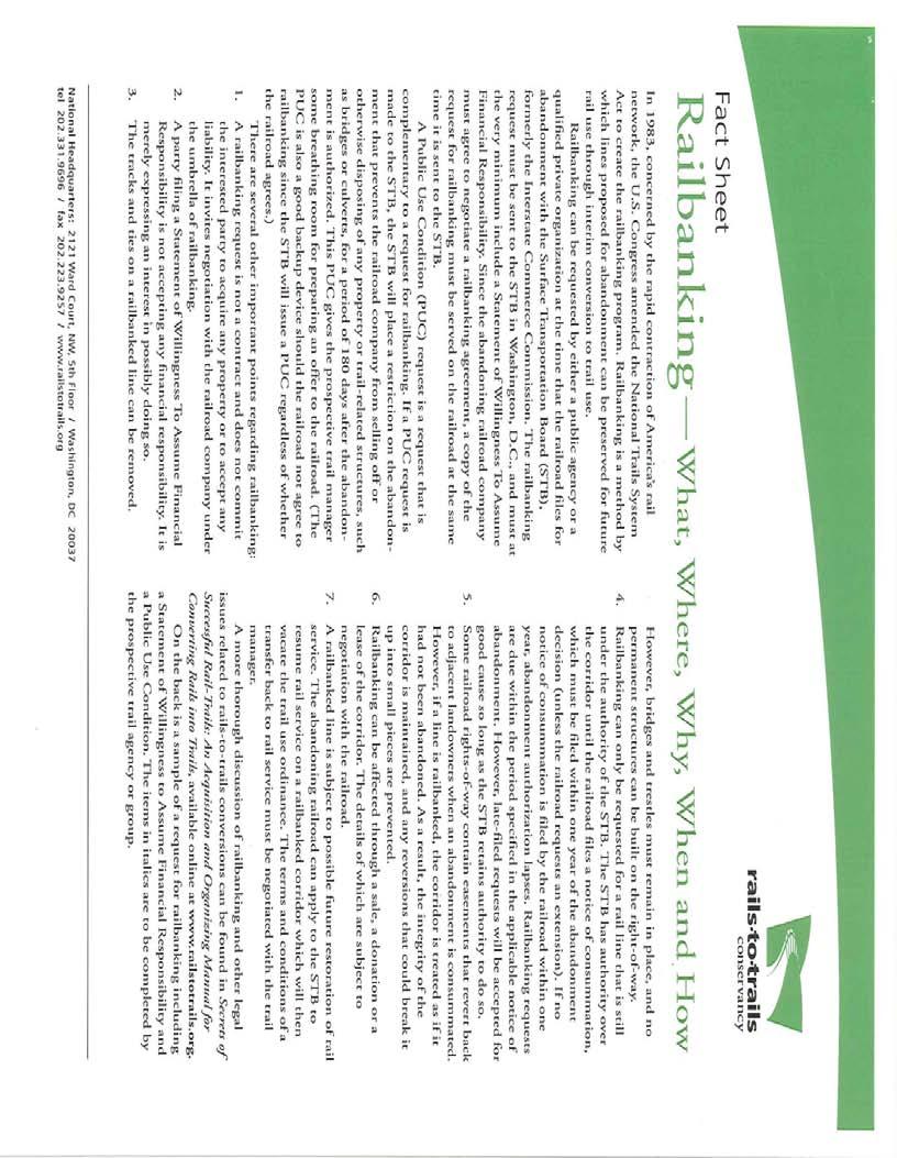
39 file:///p /Transportation/324126%20Wekiva%20Parkway%20PD&E/Gre...r%2009%2019%2008%20Mtg/Lake%20County/Lake%20Wekiva%20Trail.htm From: Eicher, Thomas Sent: Thursday, September 25, :21 AM To: Lewis, David/ORL Cc: Woods, Michael; Tara; Quigley, Gallus; David Graeber; Bill. Bonilla, Roberto; Subject: Lake Wekiva Trail Attachments: rail bank.pdf Good morning Dave, Thank you for the opportunity to review the Technical memorandum titled Trail Assessment for the Wekiva Parkway /SR 46 Realignment PD&E Study at the meeting held in you office on Friday September 19, It is our understanding that your task is to provide an analysis of whether or not the trail alternatives shown in the Lake County Trails Master Plan could be reasonably accommodated. In addition, it is not the intent of your analysis to discuss the funding of the trails or the related issue of bicycle-pedestrian connectivity. Based on our review of the materials and information presented, the Wekiva Parkway could accommodate the planned Lake-Wekiva Trail and the West Orange Trail Connector. We request that a clear commitment be outlined in the Environmental Assessment to require coordination with Lake county, Seminole county, Orange County, The East central Florida Regional Planning Council, Mount Dora and the Lake-Sumter MPO prior to approval of any future design scope for phases of the Wekiva Trail. Two issues concern Lake County. The first issue involves the intersection of the widened and realigned SR 46 with the trail about 1600 east of Round Lake road. The concept plans for SR 46 are shown to intersect the active CSX railroad near a proposed signal. While these plans could accommodate a trail with either a trail overpass or an atgrade crossing, the design impacts our right of way acquisition strategy. Because the railroad is active, ongoing coordination has occurred between Lake County, Mt Dora, the Lake-Sumter MPO and CSX to plan the Lake-Wekiva Trail. The current right of way acquisition strategy for this portion of rail road right of way is rail banking. I have attached a 2 page document that briefly describes this process. The preliminary design of the realigned SR 46 would make this method of acquisition impossible due to the impacts on the railroad corridor. What method of acquisition of the file:///p /Transportation/324126%20Wekiva%20Parkwa %20Mtg/Lake%20County/Lake%20Wekiva%20Trail.htm (1 of 2)10/7/ :15:34 AM
40 file:///p /Transportation/324126%20Wekiva%20Parkway%20PD&E/Gre...r%2009%2019%2008%20Mtg/Lake%20County/Lake%20Wekiva%20Trail.htm existing active railroad right of way is proposed for the Wekiva Parkway? The second issue is the replacement of the existing bicycle and pedestrian transportation connectivity for the SR 46 corridor. Presently, SR 46 provides bicycle and pedestrian transportation connectivity with paved shoulders. This transportation connectivity is severed in areas where existing SR 46 is abandoned as shown in the conceptual plans for the Wekiva Parkway. Are there plans to continue to provide future bicycle and pedestrian transportation connectivity along SR 46? On a similar note, the crossing of the Wekiva River is a critical regional and local connection for bicycles and pedestrians. The existing bicycle and pedestrian connection does not appear to be replaced. Is it the proposal of the FDOT to eliminate this connection at the time of construction of the Wekiva Parkway unless external funding is provided to construct bicycle and pedestrian accommodations? We believe bicycle and pedestrian accommodations have never been more important to our roadway transportation network. Currently, the PD&E Study of the Lake-Wekiva Trail is a prioritized project by the Lake-Sumter MPO. It is our intent that the planned Lake- Wekiva Trail be mutually beneficial in addressing the transportation and recreational needs of east Lake County, Seminole County, and Orange County. We look forward to working with you to ensure that the needs of bicyclists and pedestrians are met. Thank you for this opportunity. Tom Eicher Manager - Parks & Trails file:///p /Transportation/324126%20Wekiva%20Parkwa %20Mtg/Lake%20County/Lake%20Wekiva%20Trail.htm (2 of 2)10/7/ :15:34 AM
41

42
43 Comments from Lake-Sumter MPO Bicycle and Pedestrian Advisory Committee
44 file:///p /Transportation/324126%20Wekiva%20Parkway%20PD&E/Gre...BPAC/RE%20Wekiva%20Pkwy%20-%20Trails%20Interface%20Meeting.htm From: Woods, Michael Sent: Monday, September 29, :26 PM To: Lewis, David/ORL Subject: RE: Wekiva Pkwy - Trails Interface Meeting Attachments: Wekiva Parkway Trail Comments BPAC Sept 2008.doc Lake-Sumter MPO BPAC comments attached. Michael F. Woods Transportation Planner Lake-Sumter Metropolitan Planning Organization 1616 South 14th Street (U.S. 27) Leesburg, Florida MWoods@LakeSumterMPO.com From: David.Lewis2@CH2M.com [mailto:david.lewis2@ch2m.com] Sent: Monday, September 29, :14 PM To: Quigley, Gallus; Eicher, Thomas; dgraeber@inwoodinc.com; quinnm@ci.mount-dora.fl.us; ReggentinM@ci.mount-dora.fl.us; Beth.Jackson@ocfl.net; Bill.Thomas@ocfl.net; DMartin@seminolecountyfl.gov; MWilson@metroplanorlando.com; Woods, Michael; Burke, Thomas; tara@ecfrpc.org; Joan.Carter@dot.state.fl.us; bishopj@doacs.state.fl.us; warren.poplin@dep.state.fl.us; gregory.walker@dep.state.fl.us; Matt.Klein@dep.state.fl.us; kwimmer@fs.fed.us; meno@fs.fed.us; kschue@tnc.org; petedurnell@aol.com; chlee2@earthlink.net; daniel.mcdermott@dot.state.fl.us Cc: Brian.Stanger@dot.state.fl.us; david.marsh@dot.state.fl.us; mbrookssr417@cfl.rr.com; Mark. Callahan@CH2M.com Subject: RE: Wekiva Pkwy - Trails Interface Meeting We are completing the final report on trails accommodation for the Wekiva Pkwy PD&E Study. To date we have received comments, as requested at the Sept. 19th meeting, from the following: - FDOT, District Five Bicycle and Pedestrian Coordinator (Joan Carter) - The Nature Conservancy (Keith Schue) - Lake County Parks and Trails (Tom Eicher) - Florida Trail Association (Pete Durnell) If you wish to have your comments included in the final report, please them to me no later than Friday, Oct. 3rd. Thank you. Dave Lewis CH2MHILL From: Lewis, David/ORL file:///p /Transportation/324126%20Wekiva%20Parkway...ekiva%20Pkwy%20-%20Trails%20Interface%20Meeting.htm (1 of 2)10/7/ :15:44 AM

45 The Lake~Sumter MPO BPAC had the following recommendations concerning the Trail Assessment Study and Lake-Wekiva Trail implementation strategy. 1. Alternatives for the Lake-Wekiva Trail should be shown as part of the Wekiva Parkway Project. Alternative trail alignments as depicted in the Lake County Trails Masterplan should be included as part of the Parkway Project. 2. Currently, SR 46 accommodates bicycles utilizing paved shoulders from US 441 to the Seminole County line. As a limited access roadway, the proposed Wekiva Parkway will sever this regional connectivity by disallowing bicycles on the paved shoulders. Therefore, consideration of the impact of the proposed project on the existing local and regional, bicycle and pedestrian connectivity between Lake County and Seminole County should either be included in the Wekiva Parkway PD&E Study or evaluated as a separate PD&E Study for the Lake-Wekiva Trail. Any necessary funding for a Lake Wekiva Trail PD&E Study should occur outside the normal FDOT funding process in order to quickly resolve this issue and come to agreement with the land managers who have been involved with the Wekiva Parkway Study. Options might include issuing funding under a LAP agreement with Lake County or Mount Dora or funding a supplemental agreement with the existing PD&E Study. 3. Wekiva River Crossing: More consideration for the Bicycle and Pedestrian needs in crossing the river should be included in the Parkway PD & E. Currently SR 46 serves as the major and only crossing of the Wekiva River in this area. Florida Statute FS states bicycle and pedestrian ways shall be given full consideration in the planning and development of transportation facilities. 4. An analysis of the impacts of the improvements to SR 46 just east of Round Lake Road on the existing active FCR railroad and the long term acquisition strategy for railroad right-of-way should be included in the Wekiva Parkway PD&E Study.
46 Comments from Orange County Environmental Protection Division Green PLACE Program
47 file:///p /Transportation/324126%20Wekiva%20Parkway%20PD&E/Gre...0EPD/RE%20Wekiva%20Pkwy%20-%20Trails%20Interface%20Meeting.htm From: Sent: Tuesday, September 30, :39 AM To: Lewis, David/ORL Subject: RE: Wekiva Pkwy - Trails Interface Meeting Attachments: Green PLACE Resolution Property Uses.pdf Dave, Here are my comments Any trail through Green PLACE properties will need to be unpaved in order to comply with Property uses that was approved by the Orange County Board of County Commissioners. Attached is a copy of these Property uses. Any future alignment of a multiuse trail must be designed, planned and constructed in such a way as to not interfere or impede land management activities on any Green PLACE program. A preferred alignment would be one that followed the boundary line of the parcel as to avoid bifurcating the parcel upon which the trail is proposed. Thank you, Beth Jackson Environmental Program Supervisor Green PLACE Program Orange County Environmental Protection Division (407) (407) fax "To preserve and manage environmentally sensitive lands, protect water resource lands and to provide a quality passive recreational outdoors experience for existing and future generations. From: David.Lewis2@CH2M.com [mailto:david.lewis2@ch2m.com] Sent: Monday, September 29, :14 PM To: gquigley@lakecountyfl.gov; teicher@lakecountyfl.gov; dgraeber@inwoodinc.com; quinnm@ci. mount-dora.fl.us; ReggentinM@ci.mount-dora.fl.us; Jackson, Beth (EPD); Thomas, Bill; DMartin@seminolecountyfl.gov; MWilson@metroplanorlando.com; MWoods@LakeSumterMPO.com; tburke@lakesumtermpo.com; tara@ecfrpc.org; Joan.Carter@dot.state.fl.us; bishopj@doacs.state.fl.us; warren.poplin@dep.state.fl.us; gregory.walker@dep.state.fl.us; Matt.Klein@dep.state.fl.us; kwimmer@fs. fed.us; meno@fs.fed.us; kschue@tnc.org; petedurnell@aol.com; chlee2@earthlink.net; daniel. mcdermott@dot.state.fl.us file:///p /Transportation/324126%20Wekiva%20Parkway...ekiva%20Pkwy%20-%20Trails%20Interface%20Meeting.htm (1 of 2)10/7/ :16:07 AM

48

49
50 Comments from Florida Dept. of Agriculture and Consumer Services, Division of Forestry (Seminole State Forest)
51 file:///p /Transportation/324126%20Wekiva%20Parkway%20PD&E/Gree...estry/RE%20Wekiva%20Pkwy%20-%20Trails%20Interface%20Meeting.htm From: Bishop, Joe Sent: Thursday, October 02, :21 AM To: Lewis, David/ORL Cc: Martin, Mike; Mousel, Keith; Lovett, Ray; Keith Schue; Poplin, Warren; com; Schneider Jr, Chuck; Schreiber, Winnie Subject: RE: Wekiva Pkwy - Trails Interface Meeting David, It was unfortunate that a Division of Forestry representative was not available to attend the Wekiva Parkway Trials Interface Meeting. Please accept the following comments. I do not support locating the trail on the ground underneath or adjacent to the proposed bridged wildlife crossing areas of the Wekiva Parkway. Furthermore, I do not support retaining the paved portions of SR46 that would be adjacent to the bridged wildlife crossing areas, for use as a trail or any other use. Public use of trails established on the ground in the areas of the wildlife crossings, paved or unpaved, may discourage the use of the crossings by wildlife. I do support the concept of hanging the trail structure off of the Wekiva River Bridge. This method could also be used to incorporate the trail onto the land bridges, although it may not provide a user friendly experience, and the cost would certainly be significant. Other trail designs need to be considered to move trail away from the wildlife bridges. I would like the opportunity to participate in any future trail assessments that would potentially affect Seminole State Forest or the bridged wildlife crossings proposed for the Wekiva Parkway. Thank you for allowing me the opportunity to provide comment, and please provide me a copy of the finalized trail assessment. Joe Bishop Forestry Supervisor II Seminole State Forest Division of Forestry 9610 CR44 Leesburg, FL Office) Fax) Original Message----- From: David.Lewis2@CH2M.com [mailto:david.lewis2@ch2m.com] Sent: Friday, September 19, :02 PM To: gquigley@lakecountyfl.gov; teicher@lakecountyfl.gov; dgraeber@inwoodinc.com; quinnm@ci.mount-dora.fl.us; ReggentinM@ci.mount-dora.fl.us; Beth.Jackson@ocfl.net; Bill. Thomas@ocfl.net; DMartin@seminolecountyfl.gov; MWilson@metroplanorlando.com; MWoods@LakeSumterMPO.com; tburke@lakesumtermpo.com; tara@ecfrpc.org; Joan.Carter@dot. state.fl.us; Bishop, Joe; warren.poplin@dep.state.fl.us; gregory.walker@dep.state.fl.us; Matt. Klein@dep.state.fl.us; kwimmer@fs.fed.us; meno@fs.fed.us; kschue@tnc.org; petedurnell@aol. com; chlee2@earthlink.net; daniel.mcdermott@dot.state.fl.us file:///p /Transportation/324126%20Wekiva%20Parkway...ekiva%20Pkwy%20-%20Trails%20Interface%20Meeting.htm (1 of 2)10/7/ :16:17 AM
52 Comments from East Central Florida Regional Planning Council
53 file:///p /Transportation/324126%20Wekiva%20Parkway%20PD&E/Gree...after%2009%2019%2008%20Mtg/ECFRPC/wekiva%20trail%20comments.txt From: Sent: Thursday, October 02, :37 PM To: Lewis, David/ORL Subject: wekiva trail comments Attachments: CH2MHILL Letter.doc Dave, Our comments are attached Please contact me if you have any questions. Thank you. Tara McCue ECFRPC file:///p /Transportation/324126%20Wekiva%20Parkway% %2008%20Mtg/ECFRPC/wekiva%20trail%20comments.txt [10/7/ :53:58 AM]


54 October 7, 2008 Dave Lewis CH2MHILL 225 E. Robinson St. Suite 505 Orlando, FL RE: Wekiva Parkway Trail Interface Thank you for the opportunity to discuss the Trail Assessment for the Wekiva Parkway/SR 46 Realignment PD&E Study with other regional and local agencies and CH2MHILL. With nearly 200 miles of trails, the East Central Florida region is a leader in connected regional trail systems. The Wekiva Parkway presents various agencies and counties with the opportunity to expand significantly upon that system. The East Central Florida Regional Planning Council understands that the Wekiva Parkway ROW is sufficient to accommodate the planned Lake-Wekiva Trail and West Orange Trail Connector. However, we also recognize there are various constraints and alternatives to creating a well connected and scenic trail along the Wekiva Parkway. The bicycle and pedestrian corridors which currently exist may be impacted by the SR 46 realignment. It is important to keep this connectivity for local and regional significance. Impacted areas are encouraged to be replaced or mitigated to maintain the current regional connectivity. Although CH2MILL has identified there is sufficient ROW or alternative routes to provide a trail system along the Parkway, will OOCEA allow Parkway or SR 46 ROW to be used for trail construction and use? Discussion between the stakeholding agencies and OOCEA and FDOT should occur concerning the various sources of funding and options available to construct the trail along the right of way and other alternative routes during the development of the Wekiva Parkway. Issues identified by the counties and participating agencies during the September 19, 2008 meeting and its post correspondences need to be addressed during the PD&E study of the Wekiva Parkway.
Longmont to Boulder Regional Trail Jay Road Connection DRAFT FINAL REPORT
 Longmont to Boulder Regional Trail Jay Road Connection DRAFT FINAL REPORT December 2018 Project Summary Boulder County, Colorado, in partnership with the City of Boulder, is evaluating options for multi-use
Section II. Planning & Public Process Planning for the Baker/Carver Regional Trail began in 2010 as a City of Minnetrista initiative.
 Section II Planning & Public Process Planning for the began in 2010 as a City of initiative. city staff began discussions with the Park District on the possibility of a north/south regional trail connection
Appendix C Agency Coordination and Correspondence
 Appendix C Agency Coordination and Correspondence C-1 Florida Department of Environmental Protection (FDEP), Division of Recreation and Parks letter dated December 13, 2005 C-2 Orange County Environmental
The Chu property is a 6.57 acre parcel located in the Town of Superior on the west side of McCaslin Boulevard. In 2014, the Town of Superior acquired
 1 The Chu property is a 6.57 acre parcel located in the Town of Superior on the west side of McCaslin Boulevard. In 2014, the Town of Superior acquired the Chu property for open space with a contribution
FEASIBILITY CRITERIA
 This chapter describes the methodology and criteria used to evaluate the feasibility of developing trails throughout the study areas. Land availability, habitat sensitivity, roadway crossings and on-street
PURPOSE AND NEED (CONCURRENCE POINT 1) NEW CANADA ROAD PROJECT FROM STATE ROUTE 1 (U.S. HIGHWAY 70) TO U.S. INTERSTATE 40
 NEW CANADA ROAD PROJECT FROM STATE ROUTE 1 (U.S. HIGHWAY 70) TO U.S. INTERSTATE 40") PURPOSE AND NEED (CONCURRENCE POINT 1) NEW CANADA ROAD PROJECT FROM STATE ROUTE 1 (U.S. HIGHWAY 70) TO U.S. INTERSTATE 40 Project Description The primary purpose of this project is to improve the major
PURPOSE AND NEED (CONCURRENCE POINT 1) NEW CANADA ROAD PROJECT FROM STATE ROUTE 1 (U.S. HIGHWAY 70) TO U.S. INTERSTATE 40 Project Description The primary purpose of this project is to improve the major
WEKIVA WILD AND SCENIC RIVER ACT OF 2000
 PUBLIC LAW 106 299 OCT. 13, 2000 WEKIVA WILD AND SCENIC RIVER ACT OF 2000 VerDate 11-MAY-2000 01:59 Oct 20, 2000 Jkt 069139 PO 00000 Frm 00001 Fmt 6579 Sfmt 6579 E:\PUBLAW\PUBL299.106 APPS27 PsN: PUBL299
AGENDA ITEM 5 D WAKULLA ENVIRONMENTAL INSTITUTE (WEI) TRAIL FEASIBILITY STUDY
 TRAIL FEASIBILITY STUDY") March 19, 2018 AGENDA ITEM 5 D WAKULLA ENVIRONMENTAL INSTITUTE (WEI) TRAIL FEASIBILITY STUDY TYPE OF ITEM: Action STATEMENT OF ISSUE The Wakulla Environmental Institute (WEI) Trail is one of several trails
March 19, 2018 AGENDA ITEM 5 D WAKULLA ENVIRONMENTAL INSTITUTE (WEI) TRAIL FEASIBILITY STUDY TYPE OF ITEM: Action STATEMENT OF ISSUE The Wakulla Environmental Institute (WEI) Trail is one of several trails
2. Goals and Policies. The following are the adopted Parks and Trails Goals for Stillwater Township:
 D. PARKS AND TRAILS 1. Introduction Stillwater Township s population is relatively low, with most residents living on rural residences on large lots. The need for active park space has been minimal in
A CASE FOR COMPLETING THE JORDAN RIVER PARKWAY: A
 A CASE FOR COMPLETING THE JORDAN RIVER PARKWAY: A safe crossing at 9000 South and 850 West Proposed 9000 South Underpass Parkway Timeline Parkway, Trail, and Tourism Facts Blueprint Jordan River 1971 1973
Blueways: Rivers, lakes, or streams with public access for recreation that includes fishing, nature observation, and opportunities for boating.
 Parks, Open Space and Trails PRINCE WILLIAM COUNTY 2008 COMPREHENSIVE PLAN TRAILS PLAN CONTENTS The components of the trails plan are: Intent Definitions Goals, Policies, and Action Strategies Trails Map
SR 429/WEKIVA PARKWAY FTBA CONFERENCE March 20-21, Presented By Suzanne Phillips, P.E., FDOT District 5
 SR 429/WEKIVA PARKWAY FTBA CONFERENCE March 20-21, 2012 Presented By Suzanne Phillips, P.E., FDOT District 5 Project Description The Wekiva Parkway project constructs 25 centerline miles of new toll expressway.
Auburn Trail / Ontario Pathways Trail Connector Feasibility Study Public Information Meeting Wednesday, August 22, 2012
 Auburn Trail / Ontario Pathways Trail Connector Feasibility Study Public Information Meeting Wednesday, August 22, 2012 Purpose of Feasibility Study Purpose Evaluate the feasibility of constructing a multiuse
2017 TBARTA Future Regional Priority Projects Adopted by TBARTA Board, December 9, 2016
 2017 TBARTA Future Regional Priority Projects Adopted by TBARTA Board, December 9, 2016 Project numbers do not signify ranking they are for mapping identification purposes only. 1. 15th Street East The
Coast to Coast Connector Summit
 Project Partners Welcome to the Coast to Coast Connector Summit Winter Garden, Florida City Hall October 1, 2014 1 Why are we here? Objectives 1. Inform key stakeholders on the current state of the C2C
COMMENT PERIOD INTRODUCTION
 To: Interested Persons From: Tom Buford File: Del Rio Trail Project Date: June 8, 2018 Community Development Department Reference: NOTICE OF PREPARATION OF AN ENVIRONMENTAL IMPACT REPORT FOR THE DEL RIO
Georgetown-Lewes Rail/Trail Study. Rail/Trail Study: Cool Spring to Cape Henlopen State Park New Road Extension (House Resolution No.
 Georgetown-Lewes Rail/Trail Study Rail/Trail Study: Cool Spring to Cape Henlopen State Park New Road Extension (House Resolution No. 47) August 22, 2011 Presentation Outline Background Benefits Statewide
Business Item No
 Metropolitan Parks and Open Space Commission Meeting date: February 6, 2018 For the Community Development Committee meeting of February 20, 2018 For the Metropolitan Council meeting of February 28, 2018
APPENDIX OFFICIAL MAP ORDINANCE OF HAMILTONBAN TOWNSHIP OFFICIAL MAP NARRATIVE
 APPENDIX A OFFICIAL MAP ORDINANCE OF HAMILTONBAN TOWNSHIP OFFICIAL MAP NARRATIVE INTRODUCTION: The Official Map of Hamiltonban Township has been prepared to identify those lands and features that Hamiltonban
David Johnson. Tom, Attached please find the final scoping letter and figures for your review. David
 David Johnson From: Sent: To: Cc: Subject: Attachments: David Johnson Tuesday, April 12, 2011 4:33 PM Thomas Malecek Dave Dyer; Jason Marks (jmarks@segroup.com) VWC Scoping Letter
Parkland County Municipal Development Plan Amendment Acheson Industrial Area Structure Plan
 Parkland County Municipal Development Plan Amendment Acheson Industrial Area Structure Plan New Plan Acheson Industrial Area Structure Plan Amendment Parkland County Municipal Development Plan Board Reference
Route 29 Solutions Projects
 Your guide to the Route 29 Solutions Projects For full details & continued engagement please visit www.route29solutions.org The Route 29 Solutions Package is a $230 million investment into the improvement
4.0 Context for the Crossing Project
 4.0 Context for the Crossing Project This section provides background information about key features of the North Douglas Crossing project area, and opportunities and constraints. This information is important
1803 West Hwy 160 Monte Vista, CO (719) TTY (719)
 TTY (719)") USDA Forest Service Rio Grande National Forest http://www.fs.fed.us/r2/riogrande 1803 West Hwy 160 Monte Vista, CO 81144 (719)852-5941 TTY (719)852-6271 USDI Bureau of Land Management San Luis Valley Center
USDA Forest Service Rio Grande National Forest http://www.fs.fed.us/r2/riogrande 1803 West Hwy 160 Monte Vista, CO 81144 (719)852-5941 TTY (719)852-6271 USDI Bureau of Land Management San Luis Valley Center
White Mountain National Forest Saco Ranger District
 United States Department of Agriculture Forest Service White Mountain National Forest Saco Ranger District 33 Kancamagus Highway Conway, NH 03818 Comm: (603) 447-5448 TTY: (603) 447-3121 File Code: 1950
City of Durango 5.8 FUNDING TRAILS DEVELOPMENT
 5.8 FUNDING TRAILS DEVELOPMENT The City has been successful in establishing dedicated local funding sources as well as applying for grants to develop the City s trail system, having received nearly $2.4
Business Item No XXX. Proposed Action That the Metropolitan Council approve the Coon Creek Regional Trail Master Plan.
 Business Item No. 2015-XXX Metropolitan Parks and Open Space Commission Meeting date: July 7, 2015 For the Community Development Committee meeting of July 20, 2015 For the Metropolitan Council meeting
3. COLTA / HUGA CONNECTIONS - PRELIMINARY
 9 3. COLTA / HUGA CONNECTIONS - PRELIMINARY 3.1 COLTA The Chain of Lakes Trail Association (COLTA) trail, formerly identified as the Chester Spur Line, was completed and opened for use in June 2011. The
Committee Report. Community Development Committee For the Metropolitan Council meeting of April 13, Business Item No.
 Committee Report Business Item No. 2016-48 Community Development Committee For the Metropolitan Council meeting of April 13, 2016 Subject: Harriet Island-South St. Paul Regional Trail Master Plan, Saint
SR 934 Project Development And Environment (PD&E) Study
 Study") SR 934 Project Development And Environment (PD&E) Study Project Advisory Group Meeting March 1, 2018 State Road 934/NE/NW 79th Street from west of I-95 (NW 13th CT) to N. Bayshore Drive PD&E STUDY SR 934/NE/NW
SR 934 Project Development And Environment (PD&E) Study Project Advisory Group Meeting March 1, 2018 State Road 934/NE/NW 79th Street from west of I-95 (NW 13th CT) to N. Bayshore Drive PD&E STUDY SR 934/NE/NW
8 CROSS-BOUNDARY AGREEMENT WITH BRAMPTON TRANSIT
 8 CROSS-BOUNDARY AGREEMENT WITH BRAMPTON TRANSIT The Transportation Services Committee recommends the adoption of the recommendations contained in the following report dated May 27, 2010, from the Commissioner
RUSHMORE CONNECTOR TRAIL PROPOSAL
 PURPOSE AND NEED Background The U.S. Forest Service, Black Hills National Forest (Forest Service) has received a special use permit application from the State of South Dakota Department of Game, Fish and
Auburn Trail/Ontario Pathways Trail Connector Feasibility Study Project Advisory Group Meeting August 25, 2011 Farmington Town Hall Approved Minutes
 Auburn Trail/Ontario Pathways Trail Connector Feasibility Study Project Advisory Group Meeting August 25, 2011 Farmington Town Hall Approved Minutes Committee Members Attending: Ronald L. Brand, Director
Committee Report. Community Development Committee For the Metropolitan Council meeting of August 12, Business Item No.
 Committee Report Business Item No. 2015-168 Community Development Committee For the Metropolitan Council meeting of August 12, 2015 Subject: Coon Creek Regional Trail Master Plan, Anoka County Proposed
Blue River Trail Master Plan JSA to Town Hall June 2004
 Blue River Trail Master Plan JSA to Town Hall June 2004 Prepared for: Silverthorne Town Council Silverthorne SPORT Committee Department of Recreation and Culture Silverthorne Public Works Silverthorne
Stage 2 ION: Light Rail Transit (LRT) from Kitchener to Cambridge
 from Kitchener to Cambridge") Stage 2 ION: Light Rail Transit (LRT) from Kitchener to Cambridge Public Consultation Centre (PCC) No. 3 Please Sign-in Cambridge City Hall November 21, 2017 2:00 to 8:00pm Preston Memorial Auditorium
Stage 2 ION: Light Rail Transit (LRT) from Kitchener to Cambridge Public Consultation Centre (PCC) No. 3 Please Sign-in Cambridge City Hall November 21, 2017 2:00 to 8:00pm Preston Memorial Auditorium
Chapter 6: POLICY AND PROCEDURE RECOMMENDATIONS
 Chapter 6 POLICY AND PROCEDURE RECOMMENDATIONS FOR SRRA Below are seven policy elements that should be considered for adoption by the Southwest Regional Recreation Authority of Virginia: 1. Develop strategies
CHAPTER III: TRAIL DESIGN STANDARDS, SPECIFICATIONS & PERMITS
 CHAPTER III Trail Design Standards, Specifications & Permits This chapter discusses trail standards, preferred surface types for different activities, permits, and other requirements one must consider
Predictive Economic Impact Study for the Mount Dora to Seminole Wekiva Trail
 Predictive Economic Impact Study for the Mount Dora to Seminole Wekiva Trail Prepared By: Valerie Seidel vseidel@balmoralgroup.us 341 N. Maitland Ave., Suite 100 Maitland, FL 32751 Phone (407) 629-2185
2016 Regional Transportation Alternatives Program (TAP) Grant Application
 Grant Application") 2016 Regional Transportation Alternatives Program (TAP) Grant Application PROJECT TITLE: Yelm-Tenino Trail Extension Feasibility Study TRPC use only GENERAL PROJECT INFORMATION Agency or Organization City
2016 Regional Transportation Alternatives Program (TAP) Grant Application PROJECT TITLE: Yelm-Tenino Trail Extension Feasibility Study TRPC use only GENERAL PROJECT INFORMATION Agency or Organization City
METROPOLITAN COUNCIL 390 North Robert Street, St. Paul, MN Phone (651) TDD (651)
 TDD (651)") DATE: March 27, 2012 METROPOLITAN COUNCIL 390 North Robert Street, St. Paul, MN 55101 Phone (651) 602-1000 TDD (651) 291-0904 TO: Metropolitan Parks and Open Space Commission FROM: Arne Stefferud, Planning
DATE: March 27, 2012 METROPOLITAN COUNCIL 390 North Robert Street, St. Paul, MN 55101 Phone (651) 602-1000 TDD (651) 291-0904 TO: Metropolitan Parks and Open Space Commission FROM: Arne Stefferud, Planning
County of Sonoma Agenda Item Summary Report
 Revision No. 20170501-1 of Sonoma Agenda Item Summary Report Agenda Item Number: 37 (This Section for use by Clerk of the Board Only.) Clerk of the Board 575 Administration Drive Santa Rosa, CA 95403 To:
The Joint Charlotte County - Punta Gorda and Lee MPO Meeting has changed from 10:00 a.m. to 9:30 a.m.
 The Joint Charlotte County - Punta Gorda and Lee MPO Meeting has changed from 10:00 a.m. to 9:30 a.m. JOINT MEETING OF THE CHARLOTTE COUNTY-PUNTA GORDA METROPOLITAN PLANNING ORGANIZATION BOARD AND LEE
Non-Motorized Transportation
 Non-Motorized Transportation Non-motorized facilities are important components to the transportation system. They provide an environmentally-friendly, low-cost mode of travel. Some of the facilities can
Port Gamble Shoreline Area Conceptual Trail Proposal
 The North Kitsap Trails Association is pleased to be a partner to the Kitsap Forest and Bay Project and assist Kitsap County, Forterra, Olympic Property Group, Great Peninsula Conservancy and the Port
FUNDED FOR CONSTRUCTION
 Priority CENTRAL FLORIDA ALLIANCE 2016 SIS HIGHWAY PROJECTS FOR PRIORITIZATION FDOT Financial Project Phase(s) Estimated Management Project Name or Length Latest Project Remaining Remaining Cost Designation
FY 2018/19 CENTRAL FLORIDA MPO ALLIANCE - LIST OF PRIORITY PROJECTS
 Priority FY 2018/19 CENTRAL FLORIDA ALLIANCE - LIST OF PRIORITY PROJECTS FY 2018-2019 SIS HIGHWAY PROJECTS FDOT Financial Management Number Project Name From To Work Description Latest Project Phase Funded
4. Safety Concerns Potential Short and Medium-Term Improvements
 NH Route 104 Access Management Study Page 19 4. Safety Concerns Potential Short and Medium-Term Improvements Potential safety improvement strategies are listed by priority based on field observations by
CHAPTER 1: INTRODUCTION
 CHAPTER 1: INTRODUCTION Purpose and Scope The information presented in this report represents the study findings for the 2016 Ronan Airport Master Plan prepared for the City of Ronan and Lake County, the
HAMPTON ROADS CROSSINGS PATRIOTS CROSSING AND HRBT
 HRTPO Board Meeting March 21, 2013 Agenda ITEM #9: HAMPTON ROADS CROSSINGS PATRIOTS CROSSING AND HRBT Congestion at the Hampton Roads Bridge-Tunnel (HRBT) on I-64 has long been identified as a problem
Community Development Committee
 C Community Development Committee For the Metropolitan Council meeting of October 31, 2012 Committee Report Item:2012-316 ADVISORY INFORMATION October 16, 2012 Date Prepared: Subject: Intercity Regional
Trail Feasibility Study
 VOLUSIA COUNTY MPO CITY OF NEW SMYRNA BEACH FINAL REPORT JUNE 30, 2009 Trail Feasibility Study What s inside? 1 Introduction 2 Project Purpose & Scope 3 Physical Inventory & Assessment of Right-of- Way
Regional Wayfinding Sign Strategy Thurston County Trails 2017
 Regional Wayfinding Sign Strategy Thurston County Trails 2017 Partners: Members and partnering organizations of the Thurston Thrives Community Design Action Team City of Lacey, City of Olympia, City of
April 4, 2014 Chuck McGinness, FDOT TREASURE COAST TRAFFIC REPORT April 4 through April 11, 2014
 April 4, 2014 Chuck McGinness, 954-777-4090 Chuck.McGinness@dot.state.fl.us FDOT TREASURE COAST TRAFFIC REPORT April 4 through April 11, 2014 TREASURE COAST Construction and maintenance-related lane closures
Frequently Asked Questions on the Route 29 Solutions Improvements Projects
 Frequently Asked Questions on the Route 29 Solutions Improvements Projects Background What are the Route 29 Solutions improvement projects? These projects include the Route 29/250 Interchange ( Best Buy
DRAFT - APRIL 13, 2007 ROUTING STUDY FOR TRAIL CONNECTIONS BETWEEN CALAIS AND AYERS JUNCTION
 DRAFT - APRIL 13, 2007 ROUTING STUDY FOR TRAIL CONNECTIONS BETWEEN CALAIS AND AYERS JUNCTION Abstract The vision for the East Coast Greenway is an off-road urban trail system running from Calais, Maine
Lake Erie Commerce Center Traffic Analysis
 LOCATION: East of NYS Route 5 at Bayview Road Town of Hamburg Erie County, New York PREPARED BY: Wendel Companies 140 John James Audubon Parkway Suite 200 Amherst, New York 14228 January 2012 i ii Table
ANCLOTE COASTAL TRAIL ALTERNATIVES ANALYSIS STUDY
 ANCLOTE COASTAL TRAIL ALTERNATIVES ANALYSIS STUDY PASCO COUNTY MPO JULY 2015 PROJECT OVERVIEW... INTRODUCTION EXECUTIVE SUMMARY CONTEXT... TAMPA BAY AREA, PINELLAS, & PASCO COUNTY S MULTI-USE TRAIL PLANS
White Mountain National Forest Saco Ranger District
 United States Department of Agriculture Forest Service White Mountain National Forest 33 Kancamagus Highway Conway, NH 03818 Comm: (603) 447-5448 TTY: (603) 447-3121 File Code: 1950 Date: February 26,
S Central Coast Heritage Protection Act APRIL 21, 2016
 STATEMENT OF GLENN CASAMASSA ASSOCIATE DEPUTY CHIEF, NATIONAL FOREST SYSTEM U.S. FOREST SERVICE U.S. DEPARTMENT OF AGRICULTURE BEFORE THE UNITED STATES SENATE COMMITTEE ON ENERGY AND NATURAL RESOURCES
Coronado National Forest Santa Catalina Ranger District
 United States Department of Agriculture Forest Service Coronado National Forest Santa Catalina Ranger District File Code: 1950 Date: October 14, 2015 Dear Interested Party: The Santa Catalina Ranger District
Hudson Highlands Fjord Trail Draft Master Plan. April 29, 2015
 Hudson Highlands Fjord Trail Draft Master Plan April 29, 2015 Agenda Route Overview Proposed Segment Results of Community Survey on that Segment Next Steps Municipal Endorsement Environmental Review Implementation
Citrus Heights Creek Corridor Trail Project Trail Advisory Group Field Trip #2 September 11, :00 11:00 am Trellis Hall, Citrus Heights
 September 11, 2013 9:00 11:00 am Trellis Hall, Citrus Heights Project Overview The City of Citrus Heights is studying the feasibility of establishing a multi use trail system within the City s 26 miles
FINAL. Bicycle/Pedestrian Feasibility Study City of DeBary Dirksen Drive Trail. Prepared For: Volusia County MPO
 City of DeBary Dirksen Drive Trail FINAL Prepared By: Reynolds, Smith and Hills, Inc. Prepared For: Volusia County MPO September 2007 Table of Contents INTRODUCTION...1 PROJECT PURPOSE AND SCOPE...2 PHYSICAL
University Region Non-Motorized Plan 2015
 Non-Motorized Transportation Non-motorized facilities are important components to the transportation system. They provide an environmentally-friendly, low-cost mode of travel. Some of the facilities can
Trail # NW Tuesday, June DESIGN. Provide an Review the Provide an. Project Goals: System system. wayfinding
 I. Welcome / Introductions Bethany Creek Trail #2 Segment 3 Neighborhood Meeting #1 Bethany Presbyterian Church 15505 NW Springville Road, Portland, OR 97229 Tuesday, June 26, 2018 @ 6:00PM Meeting Minutes
COASTAL CONSERVANCY. Staff Recommendation September 22, 2011 BAY AREA RIDGE TRAIL: HOOD MOUNTAIN TO HIGHWAY 12
 COASTAL CONSERVANCY Staff Recommendation September 22, 2011 BAY AREA RIDGE TRAIL: HOOD MOUNTAIN TO HIGHWAY 12 File No. 11-039-001 Project Manager: Betsy Wilson RECOMMENDED ACTION: Authorization to disburse
Header i
 Header i 048285014.10 Header Sub Title Body Text here. Body text here. Body text here. Section 1... 1 Executive Summary... 1 Opportunities and Constraints... 3 Overall Opportunities and Constraints Map
Becker County Trail Routing Feasibility Study
 2016 Becker County Trail Routing Feasibility Study CONNECTING DETROIT MOUNTAIN AND MOUNTAIN VIEW RECREATIONAL AREA TO THE HEARTLAND TRAIL BECKER COUNTY ULTEIG ENGINEERS Contents Acknowledgements...2 INTRODUCTION...3
April 10, Mark Stiles San Juan Public Lands Center Manager 15 Burnett Court Durango, CO Dear Mark,
 Mark Stiles San Juan Public Lands Center Manager 15 Burnett Court Durango, CO 81301 Dear Mark, We are pleased to offer the following comments on the draft San Juan Public Lands Center management plans
1.2 Corridor History and Current Characteristics
 SECTION 1 Description and Background of Study Area 1.1 Introduction This preliminary engineering report was prepared for the Alaska Department of Transportation and Public Facilities (ADOT&PF). It is part
Bloor Street West Rezoning Application for a Temporary Use By-law Final Report
 STAFF REPORT ACTION REQUIRED 3741 3751 Bloor Street West Rezoning Application for a Temporary Use By-law Final Report Date: June 12, 2007 To: From: Wards: Reference Number: Etobicoke York Community Council
Proposed Official Plan Amendment 41 to the Region of York Official Plan
 COMMITTEE OF THE WHOLE NOVEMBER 18, 2002 REGION OF YORK OFFICIAL PLAN AMENDMENT 41 THE OAK RIDGES MORAINE CONSERVATION PLAN Recommendation The Commissioner of Planning recommends: 1. That the City of Vaughan
EXECUTIVE SUMMARY FALL Introduction. Findings
 EXECUTIVE SUMMARY FALL 2004 Introduction Trails are one of the most popular and highly desirable recreational resources in communities of all sizes throughout the country. In addition to providing a safe
Welcome to the Cross County Trail Public Input Session!
 Welcome to the Cross County Trail Public Input Session! Please sign in on the table below! What are we doing here? Camden County has proposed a bicycle and pedestrian trail spanning across the entire county.
Brampton, Ontario REQ. no.: PLANNING, DESIGN & DEVELOPMENT COMMITTEE
 ftorontoand REGION rv~ Conservation for The Living City May 22,2009 2I22V,5L CFN 42397 CLERK S DEPT. Mr. Peter Fay City Clerk, City of Brampton MAY 2 7 2008 2 Wellington Street West Brampton, Ontario REQ.
COASTAL CONSERVANCY. Staff Recommendation December 2, 2004 COYOTE HELLYER COUNTY PARK BAY AREA RIDGE TRAIL
 COASTAL CONSERVANCY Staff Recommendation December 2, 2004 COYOTE HELLYER COUNTY PARK BAY AREA RIDGE TRAIL File No. 04-057 Project Manager: Amy Hutzel RECOMMENDED ACTION: Authorization to disburse up to
Flow Stand Up Paddle Board Parkway Plan Analysis
 Regional Parks Department Jeffrey R. Leatherman, Director County of Sacramento Divisions Administration Golf Leisure Services Maintenance Rangers Therapeutic Recreation Services Flow Stand Up Paddle Board
JOSLIN FIELD, MAGIC VALLEY REGIONAL AIRPORT DECEMBER 2012
 1. Introduction The Federal Aviation Administration (FAA) recommends that airport master plans be updated every 5 years or as necessary to keep them current. The Master Plan for Joslin Field, Magic Valley
Memo. Orange City Trail Plan Becky Mendez, AICP Jamie Krzeminski, PE, PTOE Matt Wiesenfeld, PE, AICP. Development of the Existing and Proposed Network
 Memo Date: Friday, December 22, 2017 Project: To: From: Subject: Trail Plan Becky Mendez, AICP Jamie Krzeminski, PE, PTOE Matt Wiesenfeld, PE, AICP Development of the Existing and Proposed Network HDR
LUDLAM TRAIL CORRIDOR DISTRICT
 1 APPLICATION NO. 9 MAY 2015 CDMP CYCLE LUDLAM TRAIL CORRIDOR DISTRICT PLANNING ADVISORY BOARD November 2, 2015 BACKGROUND 2 Staff Application Former Florida East Coast railroad corridor (privately owned)
United States Department of the Interior National Park Service. Boundary Expansion Listed in National Register January 11, 2017
 NPS Form 10900-a (Rev. 8/2002) OMB No. 10240018 United States Department of the Interior National Park Service Boundary Expansion Listed in National Register January 11, 2017 National Register of Historic
West Orange Trail. Clean, Green, Fun!
 West Orange Trail Clean, Green, Fun! The West Orange Trail - when completed - will be a 36-mile, multipurpose recreational greenway containing a 14-foot wide paved surface to be enjoyed by walkers, joggers,
Gardner: overview. Santa Fe, Oregon, and California National Historic Trails UNINCORPORATED JOHNSON COUNTY OLATHE UNINCORPORATED JOHNSON COUNTY
 Santa Fe, Oregon, and California ational Historic Trails : overview 99: p.134 100: p.135 GARDER JUCTIO 102: p.137 56: p.126 EDGERTO Burlington orthern Intermodal and Logistics 98: p.133 101: p.136 S Waverly
Sawtooth National Forest Fairfield Ranger District
 United States Department of Agriculture Forest Service Sawtooth National Forest Fairfield Ranger District P.O. Box 189 Fairfield, ID. 83327 208-764-3202 Fax: 208-764-3211 File Code: 1950/7700 Date: December
Mohawk Hudson Bike Hike Trail Crossroad Connection Study
 Summary Report - April 21, 2003 Mohawk Hudson Bike Hike Trail Crossroad Connection Study Summary Report Introduction The Capital District Transportation Committee (CDTC), in partnership with Albany County,
Virginia Department of Transportation s Rural Rustic Road Program
 Virginia Department of Transportation s Rural Rustic Road Program Prepared by the Local Assistance Division Virginia Department of Transportation 1401 East Broad Street Richmond, Virginia 23219 Michael
Committee Members: Page 1 of 5
 Auburn Trail/Ontario Pathways Trail Connector Feasibility Study Project Advisory Committee Public Informational Meeting September 14, 2011 Farmington Town Hall Approved Minutes Committee Members: Ronald
Madison Metro Transit System
 Madison Metro Transit System 1101 East Washington Avenue Madison, Wisconsin, 53703 Administrative Office: 608 266 4904 Fax: 608 267 8778 TO: FROM: SUBJECT: Plan Commission Timothy Sobota, Transit Planner,
Rule Governing the Designation and Establishment of All-Terrain Vehicle Use Trails on State Land
 Rule Governing the Designation and Establishment of All-Terrain Vehicle Use Trails on State Land 1.0 Authority 1.1 This rule is promulgated pursuant to 23 V.S.A. 3506. Section 3506 (b)(4) states that an
Lafourche Parish Government REQUEST FOR QUALIFICATIONS. Landscape Architectural Services
 Lafourche Parish Government REQUEST FOR QUALIFICATIONS Landscape Architectural Services Bayou Lafourche Parish Multi-Use Path Feasibility Study Phase 1 And Bayou Lafourche Parish Multi-Use Path Feasibility
Establishing a National Urban Park in the Rouge Valley
 STAFF REPORT ACTION REQUIRED Establishing a National Urban Park in the Rouge Valley Date: March 29, 2012 To: From: Wards: Reference Number: Executive Committee Deputy City Manager, Cluster B All p:\2012\cluster
Airport Planning Area
 PLANNING AREA POLICIES l AIRPORT Airport Planning Area LOCATION AND CONTEXT The Airport Planning Area ( Airport area ) is a key part of Boise s economy and transportation network; it features a multi-purpose
MONTGOMERY COUNTY PLANNING DEPARTMENT THE MARYLAND-NATIONAL CAPITAL PARK AND PLANNING COMMISSION
 MONTGOMERY COUNTY PLANNING DEPARTMENT THE MARYLAND-NATIONAL CAPITAL PARK AND PLANNING COMMISSION Three Sisters Road: Abandonment No. AB740 MCPB Item No. 11 Date: 5-1-14 Katherine Holt, Senior Planner,
Wilderness Process #NP-1810: Your letter ID is NP September 5, 2018
 Wilderness Process #NP-1810: Your letter ID is NP-1810-2602-96 September 5, 2018 RE: GMUG Wilderness Evaluation Revised Evaluation Criteria and Draft Report Forest Revision Planning Team: The Continental
Community Development
 Community Development City & Borough of Juneau Community Development 155 S. Seward Street Juneau, AK 99801 (907) 586 0715 Phone (907) 586 4529 Fax DATE: February 11, 2016 TO: FROM: Planning Commission
Proposed Action. Payette National Forest Over-Snow Grooming in Valley, Adams and Idaho Counties. United States Department of Agriculture
 United States Department of Agriculture Forest Service January 2012 Proposed Action Payette National Forest Over-Snow Grooming in Valley, Adams and Idaho Counties Payette National Forest Valley, Adams
Re: Item 7- PR13.{)35 - Region of York Municipal Parbtership Grant Application and Approval of Two Grade-Separated Underpasses
35 - Region of York Municipal Parbtership Grant Application and Approval of Two Grade-Separated Underpasses") Office of the Clerk John D. Leach Director of Customer and Legislative Servicesffown Clerk 905-727-3123 ext. 4771 jleach@aurora.ca Town of Aurora 100 John West Way, Box 1000 Aurora, ON L4G 6J1 August 14,
Office of the Clerk John D. Leach Director of Customer and Legislative Servicesffown Clerk 905-727-3123 ext. 4771 jleach@aurora.ca Town of Aurora 100 John West Way, Box 1000 Aurora, ON L4G 6J1 August 14,
Daisy Dean Trail 628/619 ATV Trail Construction
 Background and Purpose and Need The Daisy Dean ATV Trail Construction Project is located in the Little Belt Mountains, Musselshell Ranger District, Lewis and Clark National Forest approximately 32 miles
Northeast Quadrant Distinctive Features
 NORTHEAST QUADRANT Northeast Quadrant Distinctive Features LAND USE The Northeast Quadrant includes all the area within the planning area that is east of Interstate 5 and to the north of State Route 44.