Section 4(f) and Section 6(f) Technical Analysis
|
|
|
- Phillip Wood
- 5 years ago
- Views:
Transcription

 Technical Analysis")

1 WESTSIDE SUBWAY EXTENSION PROJECT Contract No. PS Section 4(f) and Section 6(f) Technical Analysis Prepared for: Prepared by: WSP USA 851 SW Sixth Avenue, Suite 1600 Portland, Oregon FEBRUARY 2018
2
3 Table of Contents 1.0 INTRODUCTION DESCRIPTION OF ALTERNATIVES AFFECTED ENVIRONMENT Existing Section 4(f) Properties Existing Section 6(f) Properties ENVIRONMENTAL CONSEQUENCES No Build Alternative Grade-Separated Option A (GSA) Alternative Partial Grade-Separated Option B (PGSB) Alternative MEASURES TO AVOID OR MINIMIZE PROJECT EFFECTS REFERENCES... 7 Figures Figure 1. Section 4(f) Properties in the Section 4(f) Study Area... 3 Attachments Attachment A Section 4(f) and Section 6(f) Impact Assessment Methodology Memorandum Attachment B Highlands Trail De Minimis Impact Determination Attachment C Reynolds Lead De Minimis Impact Determination Attachment D CDID Ditch No. 3 De Minimis Impact Determination FEBRUARY 2018 Page i
4 Acronyms and Abbreviations CDID #1 Consolidated Diking Improvement District No. 1 DAHP Washington State Department of Archaeology and Historic Preservation EIS Environmental Impact Statement FHWA Federal Highway Administration GSA Alternative Grade-Separated Option A Alternative NEPA National Environmental Policy Act PGSB Alternative Partial Grade-Separated Option B Alternative Section 4(f) Section 4(f) of the U.S. Department of Transportation Act of 1966 Section 6(f) Section 6(f) of the Land and Water Conservation Fund Act SR State Route WSDOT Washington State Department of Transportation Page ii FEBRUARY 2018
5 1.0 INTRODUCTION The Industrial Way / Oregon Way Intersection Project is located in the industrial area of Longview, Washington at the intersection of Industrial Way (State Route (SR) 432), Oregon Way, and SR 433. This intersection provides a critical connection of two Highways of Statewide Significance that support significant passenger and freight truck movement. The purpose of the project is to develop an affordable long-term solution that: Maintains or improves emergency response Improves travel reliability for all vehicles Accommodates current and future freight truck and passenger vehicle movement through the intersection and across the region and states. The purpose of this document is to describe the existing Section 4(f) properties and discuss effects and benefits the project would have on those properties. The information contained in this technical analysis supports the project s Environmental Impact Statement (EIS). Methodology for the analysis contained in this document is presented in the Impact Assessment Methodology memorandum included as Attachment A. 2.0 DESCRIPTION OF ALTERNATIVES Three alternatives are being evaluated to address the project s purpose and need: the No Build Alternative, the Grade-Separated Option A Alternative (GSA Alternative), and the Partial Grade- Separated Option B Alternative (PGSB Alternative). Each alternative is described in Chapter 2 of the project s EIS. 3.0 AFFECTED ENVIRONMENT Section 4(f) of the U.S. Department of Transportation Act of 1966 specifies that the Secretary of Transportation may approve a transportation program or project requiring the use of publicly owned land of a public park, recreation area, or wildlife or waterfowl refuge of national, state, or local significance, or land of an historic site of national, state, or local significance (as determined by the federal, state, or local officials having jurisdiction over the park, area, refuge, or site) only if: There is no prudent and feasible alternative to using that land; and The program or project includes all possible planning to minimize harm to the park, recreation area, wildlife and waterfowl refuge, or historic site resulting from the use. The Land and Water Conservation Fund Act State Assistance Program, Section 6(f), was established by the Land and Water Conservation Fund Act of The program provides matching grants to states and through states to local units of government, for the acquisition and development of public outdoor recreation sites and facilities. Property acquired or developed with Land and Water Conservation Fund assistance shall be retained and used for public outdoor recreation. Any property so acquired and/or developed shall not be wholly or partly converted to other than public outdoor recreation uses without the approval of the National Park Service pursuant to Section 6(f)(3) of the Land and Water Conservation Fund Act and the Land and Water Conservation Fund State Assistance Program Federal Financial Assistance Manual (2008). FEBRUARY 2018 Page 1
6 3.1 Existing Section 4(f) Properties Recreation facilities qualify as Section 4(f) properties if they are publicly-owned, open to the public during normal hours of operation and serve recreation activities as a major purpose as stated in adopted planning documents. Historic properties listed or eligible for listing on the National Register of Historic Places qualify as Section 4(f) properties. There is one recreational facility and two historic properties located in the study area, shown in Figure 1, that qualify as Section 4(f) properties: Highlands Trail: 1.3-mile pedestrian and bicycle trail that runs parallel to CDID Ditch No. 3 along the southern perimeter of the Highlands Neighborhood CDID Ditch No. 3: Historic ditch used to control flooding in the City of Longview; this ditch runs parallel to Industrial Way and crosses under Oregon Way in two culverts Reynolds Lead: Historic railroad segment built in the 1920s connecting from the Longview Switching Company s rail yard to the former Reynolds Aluminum Smelter. The three Section 4(f) properties are described in greater detail in the Section 4(f) de minimis Impact Determinations included as Attachments B, C, and D. There are no parks or wildlife or waterfowl refuges in the study area. 3.2 Existing Section 6(f) Properties A list of all projects funded by Land and Water Conservation Fund grants within Cowlitz County, and would thus qualify for protection under Section 6(f) was reviewed (NPS 2015). It was determined that all projects that have received such grants are outside the limits of the study area and beyond the immediate project vicinity; therefore, there are no properties in the study area subject to analysis under Section 6(f). Page 2 FEBRUARY 2018
7 Figure 1. Section 4(f) Properties in the Section 4(f) Study Area FEBRUARY 2018 Page 3
8 4.0 ENVIRONMENTAL CONSEQUENCES Under both the GSA Alternative and the PGSB Alternative, the three Section 4(f) properties would experience de minimis impacts as described and illustrated in the Section 4(f) de minimis Impact Determinations (Attachments B, C, and D) and summarized below. Documentation of coordination with the officials with jurisdiction, the City of Longview for the Highlands Trail and the Washington State Department of Archaeology and Historic Preservation (DAHP) for the CDID Ditch No.3 and the Reynolds Lead, is included in the Section 4(f) de minimis Impact Determinations (Attachments B, C, and D). There would be no constructive use to these resources, as impacts would not substantially impair the attributes of the historic resources or recreational opportunities of the recreation resource (trail). 4.1 No Build Alternative Under the No Build Alternative, there would be no Section 4(f) use of any of the Section 4(f) properties. 4.2 Grade-Separated Option A (GSA) Alternative Highlands Trail Construction of the GSA Alternative would result in a de minimis impact to the Highlands Trail for the following reasons: 1. Acquisition areas would not physically change the existing trail 2. Access to the trail from Oregon Way and other local streets would remain unchanged 3. Changes in noise, air quality, and the visual setting from the trail would not significantly alter the experience of trail users 4. Noise, dust, and visual disruptions during construction would be temporary in nature. 5. Only the eastern most portion of the trail between 17 th Avenue and Oregon Way would be temporarily closed during construction (up 1.5 years during closure of Oregon Way), and users would still be able to access the remaining length of the trail from other access points. 6. Acquisitions from the City of Longview parcels in which the trail is located would represent a small portion of these parcels. The existing trail facility does not extend into the portion of the parcels that would be acquired. 7. Temporary easements from the City of Longview parcels would also represent a small portion of the area owned by City for the trail and would only be in effect during project construction, which could last up to 5 years Reynolds Lead Construction of the GSA Alternative would result in a de minimis impact to the Reynolds Lead for the following reasons: 1. The realigned segment of the rail line represents only a small portion of the historic alignment 2. The overall alignment of the rail line would remain unchanged 3. Trains would continue to operate on the line in the same manner they do today Page 4 FEBRUARY 2018
9 4. Acquisitions from the Reynolds Lead right-of-way would represent a small portion of the total area owned by BNSF Railway and Union Pacific Railroad (UPRR) for the Reynolds Lead. 5. Temporary easements from the Reynolds Lead right-of-way would also represent a small portion of the area owned by BNSF Railway and UPRR for the Reynolds Lead and would only be in effect during project construction, which could last up to 5 years. 6. Changes in noise, air quality, and the visual setting would not substantially alter the context and setting 7. Noise, dust, and visual disruptions during construction would be temporary in nature CDID Ditch No. 3 Construction of the GSA Alternative would result in a de minimis impact to CDID Ditch No. 3 for the following reasons: 1. The replaced or extended culverts under Oregon Way (modern additions to the system; not contributing elements to the historic resource) would continue to convey water in CDID Ditch No. 3 in the same manner it is currently conveyed 2. Access to CDID Ditch No. 3 and the Oregon Way Pump Station (a modern addition to the system; not a contributing element to the historic resource) would continue to be provided from Oregon Way 3. Acquisitions from the CDID #1 parcels would represent a small portion of the total area owned by CDID #1 for CDID Ditch No Temporary easements from the CDID #1 parcels would also represent a small portion of the area owned by CDID #1 for CDID Ditch No. 3 and would only be in effect during project construction, which could last up to 5 years. 5. Changes in noise, air quality, and the visual setting would not substantially alter the context and setting 6. Noise, dust, and visual disruptions during construction would be temporary in nature. 4.3 Partial Grade-Separated Option B (PGSB) Alternative Highlands Trail Construction of the PGSB Alternative would result in a de minimis impact to the Highlands Trail for the same reasons as described under the GSA Alternative in Section except that Oregon Way would not be closed so that closures of the portion of the trail between 17 th Avenue and Oregon Way would likely be much shorter in duration, and construction would only be expected to last for up to 3.5 years, so the duration of temporary easements would be shorter than under the GSA Alternative Reynolds Lead Construction of the PGSB Alternative would result in a de minimis impact to the Reynolds Lead for the following reasons: 1. The rail alignment would not be physically altered 2. The new elevated structures over the rail segment would not alter the rail alignment 3. Trains would continue to operate on the line in the same manner they do today FEBRUARY 2018 Page 5
10 4. Permanent easements from the Reynolds Lead right-of-way would represent a small portion of the total area owned by BNSF Railway and UPRR for the Reynolds Lead. 5. Temporary easements from the Reynolds Lead right-of-way would also represent a small portion of the area owned by BNSF Railway and UPRR for the Reynolds Lead and would only be in effect during project construction, which could last up to 3.5 years. 6. Changes in noise, air quality, and the visual setting would not substantially alter the context and setting 7. Noise, dust, and visual disruptions during construction would be temporary in nature CDID Ditch No. 3 Construction of the PGSB Alternative would result in a de minimis impact to CDID Ditch No. 3 for the same reasons as described under the GSA Alternative in Section except construction would only be expected to last for up to 3.5 years, so the duration of temporary easements would be shorter than under the GSA Alternative. 5.0 MEASURES TO AVOID OR MINIMIZE PROJECT EFFECTS Highlands Trail Measures to avoid, minimize, and mitigate impacts or provide enhancement to the Highlands Trail under both the GSA and PGSB Alternatives include: 1. The project has been designed to avoid physical impacts to the Highlands Trail, including its connection to the Oregon Way sidewalk. 2. During construction, pedestrians and bicyclists would be able to use the segment of the trail west of 17 th Avenue. A signed detour route would be provided for the 0.2-mile segment between 17 th Avenue and Oregon Way. 3. The project has been designed such that it would not change or preclude the future extension of the trail east across Oregon Way. 4. The project would construct new sidewalks and a new shared-use path within the intersection vicinity, enhancing overall pedestrian and bicycle connectivity and improving access to the Highlands Trail Reynolds Lead Measures to avoid, minimize, and mitigate impacts or provide enhancement to the Reynolds Lead under both the GSA and PGSB Alternatives include: 1. The project has been designed to maintain the overall alignment of the rail line and ensure that trains can continue to operate in the same manner that they do today. 2. Rail operations would not be interrupted during construction. 3. The new elevated structures have been designed to avoid interference with or changes to rail operations. Additional measures under the PGSB Alternative include: 1. The project has been designed to avoid changes to the historic rail alignment. Page 6 FEBRUARY 2018
11 5.1.3 CDID Ditch No. 3 Measures to avoid, minimize, and mitigate impacts or provide enhancement to CDID Ditch No. 3 under both the GSA and PGSB Alternatives include: 1. The project has been designed to maintain the historic alignment of the ditch. 2. Access to the Oregon Way Pump Station would be maintained. 3. The construction contractor would be required to submit a culvert bypass plan and to maintain water flow and connectivity of the ditch during construction. 6.0 REFERENCES City of Longview Park and Recreation Plan. Available at: Retrieved from website January 21, City of Longview Parks & Recreation Comprehensive Plan Available at: Retrieved from website February 5, Cowlitz County Cowlitz Regional Trails Plan. Available at: Retrieved from website January 21, National Park Service LWCF in your Neighborhood: Detailed Listing of Grants by County. Retrieved from website September 16, WSP A Cultural Resources Survey for the Proposed Industrial Way Oregon Way Intersection Project. TDN.com. Longview to add new walking path near the Highlands. Available at: Retrieved from website January 25, FEBRUARY 2018 Page 7
12 This page intentionally left blank. Page 8 FEBRUARY 2018
13 Attachment A: Section 4(f) and Section 6(f) Impact Assessment Methodology Memorandum FEBRUARY 2018 Page A-1
14 Memorandum WESTSIDE SUBWAY EXTENSION PROJECT Contract No. PS To: From: Joanna Lowrey, PE, WSDOT Kelso Area Engineer Claude Sakr, Cowlitz County Project Manager Jennifer Rabby, AICP, WSP Date: April 1, 2016 Revised October 13, 2017 Subject: Impact Assessment Methodology: Section 4(f) and Section 6(f) 1 Methodology Introduction This memorandum presents the methodology used to analyze potential effects of the proposed Industrial Way/Oregon Way Intersection Project on Section 4(f) and Section 6(f) resources. This analysis is included in Appendix M (Section 4(f) Technical Analysis) of the environmental impact statement (EIS) prepared for the project. 2 Study Area The study area for Section 4(f) and Section 6(f) is shown in Figure A-1 below. The study area encompasses the area for direct and indirect impacts to Section 4(f) and Section 6(f) resources resulting from the project. Page A-2 FEBRUARY 2018


 Study")


15 Figure A-1. Section 4(f) Properties in the Section 4(f)/Section 6(f) Study Area FEBRUARY 2018 Page A-3
16 3 Regulations, Standards, or Guidelines The federal, state, and local regulations, standards, and guidelines that apply to the project are listed below. National Environmental Policy Act (1969) Section 4(f) of the Department of Transportation Act of 1966 Section 6(f) of the Land and Water Conservation Fund (LWCF) Act Section 106 of the National Historic Preservation Act of 1966 Federal Highway Administration (FHWA) Technical Advisory T A: Guidance for Preparing and Processing Environmental and Section 4(f) Documents (1987) FHWA: Section 4(f) Policy Paper (2012) Washington State Department of Transportation (WSDOT) Environmental Manual Chapter 457 (2017) WSDOT PRO 457 a: Recommended Procedure for Conducting a Section 4(f) Evaluation WSDOT Section 4(f) Guidance Website 4 Sources of Existing Data Existing data sources that were used for the Section 4(f) and Section 6(f) analysis include: Google Earth and Google Street View Cowlitz-Wahkiakum Council of Governments (CWCOG) GIS data Cowlitz County NetMaps Cowlitz County Regional Trails Plan (2006) City of Longview Parks and Recreation Comprehensive Plan (2016 Update) Longview Online Maps National Park Service LWCF in your Neighborhood Detailed Grant Listing: Cowlitz County SR 432 Rail Realignment & Highway Improvements Project Final Environmental Inventory and Overview for Select Resources (2014) Page A-4 FEBRUARY 2018
17 5 Data Gathering or Development In addition to the existing data already available (described above), the Cultural Resource Discipline Report for the project identifies and documents the boundaries, characteristics, and key features of historic resources eligible for listing on the National Register of Historic Places, which qualify as Section 4(f) properties. Recreational resources that qualify as Section 4(f) properties were identified through review of the City of Longview s Parks and Recreation Plan and aerial mapping. There are no wildlife and waterfowl refuges in the Section 4(f)/Section 6(f) study area. A site visit was conducted to photograph and further document the characteristics of any park and recreational resources that qualify as Section 4(f) properties. In addition, the Section 4(f) evaluation relies upon data from WSDOT designers to create graphics that show the following for each alternative: 1) temporary construction footprint, including temporary construction easements and access changes; 2) permanent project footprint of the new facility; and 3) the area to be acquired from each parcel. A list of all projects funded by Land and Water Conservation Fund grants within Cowlitz County, and would thus qualify for protection under Section 6(f) was reviewed. It was determined that all projects that have received such grants are outside the limits of the Section 4(f)/Section 6(f) study area and beyond the immediate project vicinity; therefore, there are no properties in the study area subject to analysis under Section 6(f). 6 Analytical Techniques and Models The Section 4(f) analysis generally follows the process described in WSDOT s Environmental Manual Chapter 457 and on WSDOT s Section 4(f) Guidance website; however, this analysis is also right-sized for the project. The only impacts the project is expected to have to Section 4(f) properties would be minimal and would not exceed the threshold for de minimis impacts. WSDOT s de minimis form/template was used to prepare de minimis determinations documenting these impacts. The public will be notified of the de minimis determination and given the opportunity to comment as part of the public hearing and comment period for the project s Draft EIS. Written concurrence by the official(s) with jurisdictions will be obtained by WSDOT for the de minimis determinations. 6.1 Construction Impacts Construction impacts to Section 4(f) properties were assessed through coordination with WSDOT and Cowlitz County to review the temporary construction footprint and how construction activities could impact access and use of these properties. The analysis also includes a discussion of whether any temporary construction easements would be needed for project construction, and how that might impact the Section 4(f) properties. 6.2 Direct Impacts (Use) Assessment of use of Section 4(f) properties was analyzed by reviewing the data sources described above to identify changes to Section 4(f) properties located in the study area that would result from project construction, such as acquisition and conversion of portions of these properties to right-of-way. FEBRUARY 2018 Page A-5
18 6.3 Indirect Impacts Proximity (indirect) impacts to Section 4(f) properties which are not directly impacted were assessed by reviewing the potential for changes in noise, aesthetics, vibrations, and access that could result from construction of the project, even if those changes do not take place directly on the Section 4(f) property itself. 7 Summary of Potential Impacts and Mitigation The following is a brief summary of the types of benefits and adverse impacts that may result from the project. This section also includes mitigation measures that could be considered to reduce or eliminate adverse impacts. 7.1 Potential Benefits Potential benefits to Section 4(f) properties could include: Improved traffic flow through the study area, thereby facilitating vehicular access to Section 4(f) properties Enhanced pedestrian and bicycle facilities and connections to Section 4(f) properties 7.2 Potential Adverse Impacts Potential adverse impacts to Section 4(f) properties could include: Permanent acquisition and conversion of land that is part of a Section 4(f) property Temporary occupancy of land that is part of a Section 4(f) property Proximity impacts to Section 4(f) properties including noise, vibrations, aesthetics, or access 7.3 Potential Mitigation Mitigation measures to avoid, minimize, or mitigate impacts to Section 4(f) properties were developed in consultation with WSDOT, Cowlitz County, and the official with jurisdiction for each Section 4(f) property. Efforts to limit impacts to the level of de minimis were explored and documented. 8 Limitations and Constraints As noted earlier, it is expected that any impacts will not exceed the threshold for de minimis impacts and de minimis determinations were prepared. Should impacts exceed this level, an individual Section 4(f) evaluation would need to be prepared in accordance with WSDOT and FHWA s guidance documents to show that there is no feasible and prudent alternative to the non-de minimis use of the Section 4(f) resource. There are no park and recreation facilities in the study area that were purchased or improved with money from the Land and Water Conservation Fund; therefore, none of the Section 4(f) properties need to be evaluated under Section 6(f) of the Land and Water Conservation Fund Act of Page A-6 FEBRUARY 2018
19 Attachment B: Highlands Trail De Minimis Impact Determination FEBRUARY 2018 Page B-1
20 Section 4(f) De Minimis Impact Determination (per 23 CFR 771) Summary Table Date: February 13, 2018 WSDOT Region: Project Number: Project: Project Description: Section 4(f) Resource: Type of 4(f) Resource: Size of the de minimis use of the 4(f) Resource (in acres): Primary Purpose/Function of the 4(f) Resource: Official with Jurisdiction: Southwest Region STPUS-HLP-0432(019), TA5572 Industrial Way/Oregon Way Intersection Project The Industrial Way / Oregon Way Intersection Project is located in the industrial area of Longview, Washington at the intersection of Industrial Way (State Route (SR) 432), Oregon Way, and SR 433. This intersection provides a critical connection of two Highways of Statewide Significance that support significant passenger and freight truck movement. The purpose of the project is to develop an affordable long-term solution that: Maintains or improves emergency response Improves travel reliability for all vehicles Accommodates current and future freight truck and passenger vehicle movement through the intersection and across the region and states. Two build alternatives are being considered, as documented in the project s Environmental Impact Statement (EIS). Highlands Trail Public Park or Recreational Area GSA Alternative: 1,300 square feet (< 0.1 acres) of 2.7-acre parcel; 0 feet of existing trail permanently impacted PGSB Alternative: 1,100 square feet (<0.1 acres) of 2.7-acre parcel; 0 feet of existing trail permanently impacted Recreational trail City of Longview, Washington Page B-2 FEBRUARY 2018
 property and the attributes and features that qualify it for Section 4(f) protection, attach a map showing the boundaries of the resource, the locations of key features (e.g. ball fields, structures) and the area to be used.")

21 De minimis Documentation 1. Describe the Section 4(f) property and the attributes and features that qualify it for Section 4(f) protection, attach a map showing the boundaries of the resource, the locations of key features (e.g. ball fields, structures) and the area to be used. The Highlands Trail is identified in the City of Longview s Park and Recreation Comprehensive Plan (2016 update) and in the Cowlitz Regional Trail Plan (2006) as the Industrial Way Trail. The existing segment of the trail is signed as the Highlands Trail. The 10-foot wide paved pathway is 1.3 miles long and runs parallel to the north side of the Consolidated Diking Improvement District No. 1 (CDID #1) Ditch No. 3 and a Bonneville Power Administration (BPA) transmission line (see Photo 1). The trail extends from Douglas Street at the west end of the Highlands neighborhood to Oregon Way at the east end of the neighborhood, as shown in Figure 1. This off-road pathway serves bicyclists and pedestrians and was constructed in Pedestrian and bicycle access to the trail is provided via a public sidewalk on the west side of Oregon Way that extends north from the trail terminus and at the southern termini of some streets within the Highlands neighborhood such as 17 th Avenue (see Photo 2). The existing sidewalk from the north on the west side of Oregon Way ends at the connection with the trail and does not connect south to Industrial Way (see Photo 3). This trail provides a pedestrian and bicycle connection to Archie Anderson Park, which contains recreation amenities (baseball diamonds, basketball hoops, tennis courts, and play structures) and is located just north of the Section 4(f) study area. The Cowlitz Regional Trails Plan (2006) and the City of Longview Parks and Recreation Comprehensive Plan (2016) identify extensions of this trail both to the east and to the west. The City s Plan identifies a Photo 1. The Highlands Trail adjacent to CDID Ditch No. 3 and BPA transmission line, looking west from Oregon Way Photo 2. Connection to the Highlands Trail from the southern terminus of 17 th Avenue FEBRUARY 2018 Page B-3

22 planned Diking District Trails system that would form a loop around the city along the CDID #1 ditches and would include the Highlands Trail. The western trail extension would connect from the terminus of the Highlands Trail continuing to follow Ditch No. 3 to the connection with CDID Ditch No. 5 (west of Prudential Boulevard), where it would connect to the future Memorial Park Drive Trail along Ditch No. 5. As shown in Figure 1, an eastern planned trail extension would cross Oregon Way Photo 3. Connection of the Highlands Trail to sidewalk on west side of Oregon Way continuing to parallel CDID Ditch No. 3 to cross California Way; from there it would continue on as the 3 rd Avenue Trail, paralleling CDID Ditch No. 4. At this time, however, the City does not own any property or easements for extension of the Highlands Trail, so these future trail extensions are an expression of interest and are not part of the Section 4(f) resource. The trail is located within land (right-of-way) owned by the City of Longview. The existing portion of the trail within the Section 4(f) study area is located in two parcels that total 2.7 acres extending between 26 th Avenue and Oregon Way and extending out into the existing right-of-way for Oregon Way. The area of these parcels to be acquired/used under the GSA and PGSB Alternatives is shown in Figure 2 and Figure 3, respectively. The area of these parcels that would be acquired/used does not include the existing trail facility, but rather the existing roadway for Oregon Way. Page B-4 FEBRUARY 2018
23 Figure 1. Existing Section 4(f) Resources FEBRUARY 2018 Page B-5


24 Figure 2. GSA Alternative Impacts to Highlands Trail Figure 3. PGSB Alternative Impacts to Highlands Trail Page B-6 FEBRUARY 2018
25 2. Describe the impacts to the Section 4(f) property, and any avoidance, minimization and mitigation or enhancement measures, and why they are considered de minimis as defined in 23 CFR Trail Facility Under both build alternatives, the eastern terminus of the trail at Oregon Way is its connection to the sidewalk along Oregon Way that extends north from the trail. The roadway improvements have been configured such that the existing segment of the Highlands Trail, including the connection to the Oregon Way sidewalk, would remain physically unchanged; the existing 1.3-mile trail would not be reduced or extended in length as a result of the project. A small portion (1,300 square feet for the GSA Alternative; 1,100 square feet for the PGSB Alternative) of the 2.7 acres of the City of Longview s parcels in which the trail is located would be acquired for roadway right-of-way as shown above in Figure 2 and Figure 3. The area of these parcels that would be acquired/used does not include the existing trail facility, but rather the existing roadway for Oregon Way. In order to construct either alternative, a temporary construction easement would also be needed from the City of Longview s parcels for the duration of construction, as shown above in Figure 2 and Figure 3; this area would include the sidewalk on Oregon Way where it connects to the Highlands Trail. For the GSA Alternative, the temporary construction easement would be 400 square feet; for the PGSB Alternative it would be 700 square feet. Construction of the GSA Alternative is anticipated to last up to 5 years, while construction of the PGSB Alternative is anticipated to last up to 3.5 years. Trail Access Pedestrian and bicycle access to the trail at Oregon Way would remain the same and would be unaffected by either build alternative except for potential temporary closures of this access point during construction to ensure user safety. During temporary closures, pedestrians and bicyclists could still access the trail from the southern termini of 17 th Avenue and from Archie Anderson Park. 17 th Avenue would be signed as the detour route for the trail during construction and the 0.2-mile section of trail between 17 th Avenue and Oregon Way would be temporarily closed. Construction of the GSA Alternative would require closure of Oregon Way, including the access point to the Highlands Trails, for up to 1.5 years; the PGSB Alternative would not require closure of Oregon Way. Visual Setting Construction of either build alternative would result in changes to the visual setting that trail users experience, as described in the project s Visual Discipline Report. Construction of an elevated intersection structure would change the appearance of the Industrial Way/Oregon Way intersection, which is visible from the segment of the trail between 16 th Avenue and Oregon Way, approximately 1,000 feet long. However, the current view of the intersection is highly urbanized by the existing industrial uses and heavy vehicle traffic at the intersection, so construction of a new elevated roadway facility would change the view, but it would still be an urbanized setting. Construction of either alternative would include removal of the grove of trees in the southwestern quadrant of the intersection, somewhat diminishing the limited amount of natural scenery visible from the trail. During construction, trail users might experience additional visual disruptions from brightly colored construction signage, equipment, and lighting, but these changes would be temporary and would be removed upon completion of construction. FEBRUARY 2018 Page B-7
26 Noise Level Trail users could also experience an increased noise level during construction as a result of construction equipment. Under the GSA and PGSB Alternatives, the trail would experience higher noise levels in the future (2040) than exist today; however, these noise levels would not exceed those anticipated under the future conditions of the No Build Alternative. A sound barrier was evaluated for placement adjacent to the trail, but this barrier did not meet WSDOT feasibility and cost criteria. Air Quality Trail users might also experience additional dust and changes in air quality during construction; however, these changes would be temporary and no long-term air quality impacts would result from construction of either alternative. Trail Extension The planned extension of the Highlands Trail east of Oregon Way is an expression of interest at this time by the City of Longview. The design of the GSA and PGSB Alternatives would not change or preclude the City s plans for constructing the Diking District Trail system that would serve as an extension of the Highlands Trail east to California Way; crossing Oregon Way to access a future trail extension would be possible under either alternative. Under the GSA Alternative, pedestrians and bicycles could connect from the existing Highlands Trail to a future trail extension to the east by: 1) traveling south on the new shared-use path, sidewalks, and bike lanes associated with the new access road that passes under the elevated Oregon Way; or 2) traveling north on the existing sidewalk on Oregon Way; pedestrians and bicycles would use a marked pedestrian crossing at the Oregon Way/Alabama Street roundabout to cross to the east side of Oregon Way; from there, they would travel south on sidewalks and bike lanes associated with the new surface road to reach the trail extension (Figure 2). To reach the City s future trail extension under the PGSB Alternative, pedestrians and bicycles would travel south on the new shared-use path that would be constructed along the surface portion of Oregon Way. Pedestrians and bicycles would use a marked crossing at the Industrial Way/Oregon Way roundabout to cross to the east side of Oregon Way; from there they would travel north on a sidewalk and bike lane on the east side of Oregon Way (Figure 3). Avoidance, Minimization, and Mitigation or Enhancement Measures Measures to avoid, minimize, and mitigate impacts or provide enhancement to the Highlands Trail under both the GSA and PGSB Alternatives include: 1. The project has been designed to avoid physical impacts to the Highlands Trail, including its connection to the Oregon Way sidewalk. 2. During construction, pedestrians and bicyclists would be able to use the segment of the trail west of 17 th Avenue. A signed detour route would be provided for the 0.2-mile segment between 17 th Avenue and Oregon Way. 3. The project has been designed such that it would not change or preclude the future extension of the trail east across Oregon Way. 4. The project would construct new sidewalks and a new shared-use path within the intersection vicinity, enhancing overall pedestrian and bicycle connectivity and improving access to the Highlands Trail. Page B-8 FEBRUARY 2018
27 Summary In summary, construction of either alternative would result in a de minimis impact to the Highlands Trail for the following reasons: 1. Acquisition areas would not physically change the existing trail 2. Access to the trail from Oregon Way and other local streets would remain unchanged 3. Changes in noise, air quality, and the visual setting from the trail would not significantly alter the experience of trail users 4. Noise, dust, and visual disruptions during construction would be temporary in nature. 5. Only the eastern most portion of the trail between 17 th Avenue and Oregon Way would be temporarily closed during construction (up 1.5 years during closure of Oregon Way under the GSA Alternative; less time under the PGSB Alternative), and users would still be able to access the remaining length of the trail from other access points. 6. Acquisitions from the City of Longview parcels in which the trail is located would represent a small portion of these parcels. The existing trail facility does not extend into the portion of the parcels that would be acquired. 7. Temporary easements from the City of Longview parcels would also represent a small portion of the area owned by City for the trail and would only be in effect during project construction, which could last up to 5 years under the GSA Alternative or 3.5 years under the PGSB Alternative. 3. For parks, recreational facilities, and wildlife and waterfowl sanctuaries: a. Describe the public outreach that has been or is being conducted (leave blank for historic sites). The primary trail users are likely those that live in the adjacent Highlands Neighborhood. Project team staff have attended and presented project information at four Highlands Neighborhood Association meetings to-date, provided project update mailings, flyers, and other outreach. In addition, four public open houses have been held for the project to-date. A public hearing and open house will take place during the Draft EIS and Section 4(f) comment period. b. Attach written concurrence of the official with jurisdiction over the 4(f) resource with the de minimis determination. The project team met with the City of Longview (Official with Jurisdiction) to discuss the impacts to the Highlands Trail and the de minimis determination for this resource on August 9, Written concurrence dated October 18, 2017 is attached. FEBRUARY 2018 Page B-9
28 8. For historic resource, attach Section 106 documentation (include SHPO concurrence in projectlevel findings (DOEs and or FOEs) and Programmatic Agreement Memos for archaeological resources). Not applicable Page B-10 FEBRUARY 2018

29 FEBRUARY 2018 Page B-11
30 This page intentionally left blank. Page B-12 FEBRUARY 2018
31 Attachment C: Reynolds Lead De Minimis Impact Determination FEBRUARY 2018 Page C-1
32 Section 4(f) De Minimis Impact Determination (per 23 CFR 771) Summary Table Date: February 13, 2018 WSDOT Region: Project Number: Project: Project Description: Section 4(f) Resource: Type of 4(f) Resource: Size of the de minimis use of the 4(f) Resource (in acres): Primary Purpose/Function of the 4(f) Resource: Official with Jurisdiction: Southwest Region STPUS-HLP-0432(019), TA5572 Industrial Way/Oregon Way Intersection Project The Industrial Way / Oregon Way Intersection Project is located in the industrial area of Longview, Washington at the intersection of Industrial Way (State Route (SR) 432), Oregon Way, and SR 433. This intersection provides a critical connection of two Highways of Statewide Significance that support significant passenger and freight truck movement. The purpose of the project is to develop an affordable long-term solution that: Maintains or improves emergency response Improves travel reliability for all vehicles Accommodates current and future freight truck and passenger vehicle movement through the intersection and across the region and states. Two build alternatives are being considered, as documented in the project s Environmental Impact Statement (EIS). Reynolds Lead National Register Eligible Historic Site GSA Alternative: realign 2,000-foot segment of a 4.5-mile alignment; 1.8 acres of land acquisition PGSB Alternative: no realignment; 0.8 acre of permanent easement Historic railroad alignment BNSF Railway and Union Pacific Railroad Page C-2 FEBRUARY 2018
 property and the attributes and features that qualify if to Section 4(f) protection, attach a map showing the boundaries of the resource, the locations of key features (e.g. ball fields, structures) and the area to be used.")
33 De minimis Documentation 1. Describe the Section 4(f) property and the attributes and features that qualify if to Section 4(f) protection, attach a map showing the boundaries of the resource, the locations of key features (e.g. ball fields, structures) and the area to be used. The Reynolds Lead, shown in Figure 1 and Photo 1, is an historic railroad segment that is part of the former Longview, Portland and Northern Railway alignment originally built in the 1920s to service the growing industrial infrastructure along the banks of the Columbia River, near the then bourgeoning town of Longview. The Reynolds Lead runs approximately 4.5 miles from the former Reynolds Aluminum Smelter to the Longview Switching Company s rail yard. The line has changed ownership numerous times since then and is currently jointly owned and managed by the BNSF Railway and Union Pacific Railroad (UPRR). The railroad alignment averages 25 feet wide with a 4,600 feet long segment within the Section 4(f) study area. The Reynolds Lead is located within land (right-of-way) jointly owned by BNSF Railway and UPRR. The alignment parallels Industrial Way but crosses Industrial Way approximately 1,110 feet west of the Industrial Way/Oregon Way intersection and crosses Oregon Way approximately 350 feet north of the same intersection. The current alignment of the Reynolds Lead is consistent with the original railroad constructed in the 1920s, and it retains overall integrity especially in the areas of association, location, design, materials, and feeling. Thus, the Reynolds Lead is recommended eligible to the National Register of Historic Properties (NRHP) under Criteria A, which qualifies it as a Section 4(f) property. The area of the Reynolds Lead to be used under the GSA and PGSB Alternatives is shown in Figure 2 and Figure 3. Photo 1. Reynolds Lead on the south side of Industrial Way west of the Industrial Way/Oregon Way intersection, looking east FEBRUARY 2018 Page C-3
34 Figure 1. Existing Section 4(f) Resources Page C-4 FEBRUARY 2018


35 Figure 2. GSA Alternative Impacts to Reynolds Lead Figure 3. PGSB Alternative Impacts to Reynolds Lead FEBRUARY 2018 Page C-5
36 2. Describe the impacts to the Section 4(f) property, and any avoidance, minimization and mitigation or enhancement measures, and why they are considered de minimis as defined in 23 CFR Rail Facility Under the GSA Alternative, a segment of the Reynolds Lead, approximately 2,000 feet long, would be realigned as shown in Figure 2. Under this realignment, the Reynolds Lead would pass under the new elevated intersection to avoid at-grade rail/roadway crossings, making the transition from the south side of Industrial Way to the north side of Industrial Way further east than under the current alignment. All at-grade crossings of the Reynolds Lead with Oregon Way or Industrial Way would be eliminated. The realigned segment (approximately 2,000 feet) represents a small portion (less than 10 percent) of this 4.5-mile rail line. The overall alignment that connects the Reynolds Lead from the former Reynolds Aluminum Smelter to the Longview Switching Company s rail yard would remain unchanged, and trains would be able to continue to operate on the Reynolds Lead in the same manner that they do under present conditions. Approximately 4.9 acres of new right-of-way would be acquired for the realigned segment of the Reynolds Lead as shown in Figure 2. Approximately 1.8 acres of land owned by BNSF and UPRR would be acquired to accommodate roadway widening and stormwater treatment, and a temporary construction easement of approximately 0.2 acre would be needed for up to 5 years. The PGSB Alternative would leave the Reynolds Lead alignment in its current location. Under this alternative, the existing segment of the Reynolds Lead would remain physically unchanged, as shown in Figure 3, and trains would be able to continue to operate on the Reynolds Lead in the same manner that they do under present conditions. Two new elevated structures would be built for Oregon Way and Industrial Way to cross over the Reynolds Lead, and the at-grade crossings of these roadways would be reconstructed as part of the project to accommodate the wider roadways. Permanent easements for approximately 0.8 acre of land owned by BNSF and UPRR would be acquired to accommodate roadway widening, and a temporary construction easement of approximately 0.2 acre would be needed for up to 3.5 years. Rail Access During construction, rail access on the Reynolds Lead would be maintained under both alternatives. Noise Level, Visual Setting, and Air Quality Temporary construction impacts could include noise from construction equipment, visual changes in the setting due to the presence of construction equipment, signage, and lights, and dust generated by construction activities. These impacts, however, would be temporary in nature and would not change the setting and context of the historic resource. Avoidance, Minimization, and Mitigation or Enhancement Measures Measures to avoid, minimize, and mitigate impacts or provide enhancement to the Reynolds Lead under both the GSA and PGSB Alternatives include: 1. The project has been designed to maintain the overall alignment of the rail line and ensure that trains can continue to operate in the same manner that they do today. 2. Rail operations would not be interrupted during construction. Page C-6 FEBRUARY 2018
37 3. The new elevated structures have been designed to avoid interference with or changes to rail operations. Additional measures under the PGSB Alternative include: 1. The project has been designed to avoid changes to the historic rail alignment. Summary In summary, construction of the GSA Alternative would result in a de minimis impact to the Reynolds Lead for the following reasons: 1. The realigned segment of the rail line represents a small portion of the historic alignment 2. The overall alignment of the rail line would remain unchanged 3. Trains would continue to operate on the line in the same manner they do today 4. Acquisitions from the Reynolds Lead right-of-way would represent a small portion of the total area owned by BNSF Railway and UPRR for the Reynolds Lead. 5. Temporary easements from the Reynolds Lead right-of-way would also represent a small portion of the area owned by BNSF Railway and UPRR for the Reynolds Lead and would only be in effect during project construction, which could last up to 5 years under the GSA Alternative 6. Changes in noise, air quality, and the visual setting would not substantially alter the context and setting 7. Noise, dust, and visual disruptions during construction would be temporary in nature. Construction of the PGSB Alternative would result in a de minimis impact to the Reynolds Lead for the following reasons: 1. The rail alignment would not be physically altered 2. The new elevated structures over the rail segment would not alter the rail alignment 3. Trains would continue to operate on the line in the same manner they do today 4. Permanent easements from the Reynolds Lead right-of-way would represent a small portion of the total area owned by BNSF Railway and UPRR for the Reynolds Lead. 5. Temporary easements from the Reynolds Lead right-of-way would also represent a small portion of the area owned by BNSF Railway and UPRR for the Reynolds Lead and would only be in effect during project construction, which could last up to 3.5 years. 6. Changes in noise, air quality, and the visual setting would not substantially alter the context and setting 7. Noise, dust, and visual disruptions during construction would be temporary in nature. FEBRUARY 2018 Page C-7
38 3. For parks, recreational facilities, and wildlife and waterfowl sanctuaries: a. Describe the public outreach that has been or is being conducted (leave blank for historic sites). Not applicable b. Attach written concurrence of the official with jurisdiction over the 4(f) resource with the de minimis determination. Not applicable 4. For historic resource, attach Section 106 documentation (include SHPO concurrence in projectlevel findings (DOEs and or FOEs) and Programmatic Agreement Memos for archaeological resources). The Washington State Department of Archaeology and Historic Preservation (DAHP) concurred with the determination of eligibility (DOE) for the Reynolds Lead railway segment on January 24, 2017 (see attached letter). The project s cultural resource report (submitted to DAHP on September 25, 2017) disclosed that FHWA intends to make a de minimis determination for this resource. DAHP concurred with the finding of effect (FOE) of No Adverse Effect for this resource on October 16, 2017 (see attached letter). Page C-8 FEBRUARY 2018
39 FEBRUARY 2018 Page C-9
40 Page C-10 FEBRUARY 2018
41 Attachment D: CDID Ditch No. 3 De Minimis Impact Determination FEBRUARY 2018 Page D-1
42 Section 4(f) De Minimis Impact Determination (per 23 CFR 771) Summary Table Date: February 13, 2018 WSDOT Region: Project Number: Project: Project Description: Southwest Region STPUS-HLP-0432(019), TA5572 Industrial Way/Oregon Way Intersection Project The Industrial Way / Oregon Way Intersection Project is located in the industrial area of Longview, Washington at the intersection of Industrial Way (State Route (SR) 432), Oregon Way, and SR 433. This intersection provides a critical connection of two Highways of Statewide Significance that support significant passenger and freight truck movement. The purpose of the project is to develop an affordable long-term solution that: Maintains or improves emergency response Improves travel reliability for all vehicles Accommodates current and future freight truck and passenger vehicle movement through the intersection and across the region and states. Two build alternatives are being considered, as documented in the project s Environmental Impact Statement (EIS). Section 4(f) Resource: Consolidated Diking Improvement District #1 (CDID) Ditch No. 3 Type of 4(f) Resource: Size of the de minimis use of the 4(f) Resource (in acres): Primary Purpose/Function of the 4(f) Resource: National Register Eligible Historic Site GSA Alternative: 1.2 acres of 24.8 acres PGSB Alternative: 0.1 acres of 24.8 acres Historic diking ditch used to provide flood control Official with Jurisdiction: Consolidated Diking Improvement District No. 1 (CDID #1) Page D-2 FEBRUARY 2018
 property and the attributes and features that qualify if to Section 4(f) protection, attach a map showing the boundaries of the resource, the locations of key features (e.g. ball fields, structures) and the area to be used.")
43 De minimis Documentation 1. Describe the Section 4(f) property and the attributes and features that qualify if to Section 4(f) protection, attach a map showing the boundaries of the resource, the locations of key features (e.g. ball fields, structures) and the area to be used. Prior to development by the Long Bell Lumber Company, the Longview area was protected from flooding by seven independent operating diking districts. In 1923, the seven diking districts merged into what is now known as the Consolidated Diking Improvement District No. 1 (CDID #1). CDID Ditch No. 3 traverses the Section 4(f) study area parallel to Industrial Way, located on the north side of the roadway, as shown in Figure 1. It is unknown exactly when CDID Ditch No. 3 was originally built. CDID Ditch No. 3 is approximately 3 miles long from the intersection with Ditch No. 5 at Washington Way to the intersection with Ditches No. 4 and No. 11 near Tennant Way. CDID Ditch No. 3 also intersects with Ditch No. 1 west of Douglas Street. The segment of CDID Ditch No. 3 within the study Photo 1. CDID Ditch No. 3 with twin 48-inch culverts crossing under Oregon Way and 6-foot drainage pipe from Lake Sacajawea entering from the north. area measures approximately 30 feet wide by 2,500 feet long. A 6-foot drainage pipe from Lake Sacajawea connects and drains into CDID Ditch No. 3 with an energy dissipation feature on the north side of the ditch near Oregon Way (see Photo 1), and the Oregon Way Pump Station is located on the south side of the ditch west of Oregon Way; both features are modern additions to the system that are not contributing elements to the historic resource. Two 48-inch diameter concrete culverts, also non-contributing modern additions, convey the water under Oregon Way (see photo). The ditch retains overall integrity, especially in the areas of association, location, design, materials, and feeling. The ditch is recommended eligible to the National Register of Historic Properties (NRHP) under Criteria A for its association with the development of Longview, which qualifies it as a Section 4(f) property. CDID Ditch No. 3 is located within land (right-of-way) owned by CDID #1 that totals approximately 25 acres. The area of these parcels to be used under the GSA and PGSB Alternatives is shown in Figure 2 and Figure 3, respectively. FEBRUARY 2018 Page D-3
44 Figure 1. Existing Section 4(f) Resources Page D-4 FEBRUARY 2018


45 Figure 2. Impacts to CDID Ditch No. 3 under the GSA Alternative Figure 3. Impacts to CDID Ditch No. 3 under the PGSB Alternative FEBRUARY 2018 Page D-5
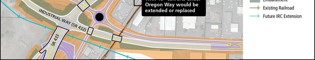
46 2. Describe the impacts to the Section 4(f) property, and any avoidance, minimization and mitigation or enhancement measures, and why they are considered de minimis as defined in 23 CFR Ditch Facility Under both build alternatives, the two 48-inch culverts that convey CDID Ditch No. 3 under Oregon Way would either be extended or replaced with longer culverts to accommodate the wider roadway that would cross over this segment of the ditch. The decision to extend or replace would be made during final design in coordination with CDID #1 and would depend on the structural integrity of the existing culverts. The culverts are not contributing elements of the historic resource, but they do maintain the historic alignment of the ditch. The wider roadway proposed under each of the build alternatives would require right-of-way easements from the CDID #1 parcels in which CDID Ditch No. 3 is located. Under the GSA Alternative, approximately 1.2 acres (52,400 square feet) would be acquired to accommodate roadway widening, culvert reconstruction/lengthening, and staging, from parcels owned by CDID #1, as shown in Figure 2, and a temporary construction easement of approximately 0.7 acre (32,400 square feet) would be needed for up to 5 years during construction of this alternative. Under the PGSB Alternative, approximately 0.1 acre (4,800 square feet) would need to be acquired to accommodate roadway widening and culvert reconstruction/lengthening from parcels owned by CDID #1, and a temporary construction easement of approximately 0.7 acre (28,900 square feet) would be needed for up to 3.5 years. Ditch Access Under either alternative, the access road to the Oregon Way Pump Station would continue to provide access from Oregon Way to this facility. Under the GSA Alternative, the access road would connect to the new surface roadway that would loop under the elevated structure. Under the PGSB Alternative, the access road would connect under the elevated structure to the surface portion of Oregon Way north of the new roundabout. Water Conveyance The construction contractor would be required to maintain water flow and connectivity of CDID Ditch No. 3 during construction. The contractor would be required to submit a culvert bypass plan outlining their construction approach. There are multiple methods that could be implemented such as replacing or extending one culvert at a time while temporarily diverting all water to the other culvert, pumping water around the culvert work area, or running a smaller pipe through the work area with cofferdams at both sides. Noise Level, Visual Setting, and Air Quality Temporary construction impacts to CDID Ditch No. 3 could include noise from construction equipment, visual changes in the setting due to the presence of construction equipment, signage, and lights, and dust generated by construction activities; however, these impacts would be temporary in nature and would not change the setting and context of the historic resource. Page D-6 FEBRUARY 2018
47 Avoidance, Minimization, and Mitigation or Enhancement Measures Measures to avoid, minimize, and mitigate impacts or provide enhancement to CDID Ditch No. 3 under both the GSA and PGSB Alternatives include: 1. The project has been designed to maintain the historic alignment of the ditch. 2. Access to the Oregon Way Pump Station would be maintained. 3. The construction contractor would be required to submit a culvert bypass plan and to maintain water flow and connectivity of the ditch during construction. Summary In summary, construction of either alternative would result in a de minimis impact to CDID Ditch No. 3 for the following reasons: 1. The replaced or extended culverts under Oregon Way (modern additions to the system; not contributing elements to the historic resource) would continue to convey water in CDID Ditch No. 3 in the same manner it is currently conveyed 2. Access to CDID Ditch No. 3 and the Oregon Way Pump Station (a modern addition to the system; not a contributing element to the historic resource) would continue to be provided from Oregon Way 3. Acquisitions from the CDID #1 parcels would represent a small portion of the total area owned by CDID #1 for CDID Ditch No Temporary easements from the CDID #1 parcels would also represent a small portion of the area owned by CDID #1 for CDID Ditch No. 3 and would only be in effect during project construction, which could last up to 5 years under the GSA Alternative or 3.5 years under the PGSB Alternative. 5. Changes in noise, air quality, and the visual setting would not substantially alter the context and setting 6. Noise, dust, and visual disruptions during construction would be temporary in nature. 3. For parks, recreational facilities, and wildlife and waterfowl sanctuaries: a. Describe the public outreach that has been or is being conducted (leave blank for historic sites). Not applicable b. Attach written concurrence of the official with jurisdiction over the 4(f) resource with the de minimis determination. Not applicable FEBRUARY 2018 Page D-7
48 4. For historic resource, attach Section 106 documentation (include SHPO concurrence in projectlevel findings (DOEs and or FOEs) and Programmatic Agreement Memos for archaeological resources). The Washington State Department of Archaeology and Historic Preservation (DAHP) concurred with the determination of eligibility (DOE) for CDID Ditch No. 3 on January 24, 2017 (see attached letter). The project s cultural resource report (submitted to DAHP on September 25, 2017) disclosed that FHWA intends to make a de minimis determination for this. DAHP concurred with the finding of effect (FOE) of No Adverse Effect for this resource on October 16, 2017 (see attached letter). Page D-8 FEBRUARY 2018

49 FEBRUARY 2018 Page D-9

50 Page D-10 FEBRUARY 2018
4.19 Parks, Recreation, and Conservation Lands
 interchange would have on the Reed Paige Clark Homestead located on the north side of Stonehenge Road. Alternative D would also affect Palmer Homestead, E.F. Adams House, and Knapp Brothers Shoe Manufacturing
West Lake Corridor Final Environmental Impact Statement/ Section 4(f) Evaluation
 Evaluation") Chapter 7 Section 4(f) Evaluation March 2018 This page intentionally left blank. March 2018 7 Section 4(f) Evaluation Chapter 7 identifies and evaluates the potential effects from the FEIS Preferred Alternative
Chapter 7 Section 4(f) Evaluation March 2018 This page intentionally left blank. March 2018 7 Section 4(f) Evaluation Chapter 7 identifies and evaluates the potential effects from the FEIS Preferred Alternative
October 18, Terry Hartwick Director, North Little Rock Parks and Recreation 2700 Willow Street North Little Rock, AR 72114
 October 18, 017 Terry Hartwick Director, North Little Rock Parks and Recreation 700 Willow Street North Little Rock, AR 7114 Dear Mr. Hartwick: Re: ARDOT Job Number CA060 30 Crossing Pulaski County The
Section 4(f)/6(f) Determination Technical Report for Park and Recreational Lands
/6(f) Determination Technical Report for Park and Recreational Lands") Section 4(f)/6(f) Determination Technical Report for Park and Recreational Lands 1.0 Introduction 1.1 Purpose of Report This Section 4(f)/6(f) Determination Technical Report for Park and Recreational Lands
Section 4(f)/6(f) Determination Technical Report for Park and Recreational Lands 1.0 Introduction 1.1 Purpose of Report This Section 4(f)/6(f) Determination Technical Report for Park and Recreational Lands
Section 106 Update Memo #1 Attachment D. Traffic Diversion & APE Expansion Methodology & Maps
 Section 106 Update Memo #1 Attachment D Traffic Diversion & APE Expansion Methodology & Maps I-65/I-70 North Split Interchange Reconstruction Project (Des. Nos. 1592385 & 1600808) Traffic Diversion and
Final Section 4(f) Evaluation
 Evaluation") Final Section 4(f) Evaluation Trunk Highway 61 State Project: 1913-64 Minnesota Project: Project Limits: Canadian Pacific Railroad to Fourth Street Cities: Hastings County: Dakota and Washington Dakota
Final Section 4(f) Evaluation Trunk Highway 61 State Project: 1913-64 Minnesota Project: Project Limits: Canadian Pacific Railroad to Fourth Street Cities: Hastings County: Dakota and Washington Dakota
This section evaluates the projected traffic operations and circulation impacts associated with the proposed upgrade and expansion of the LWRP.
 4.5 TRAFFIC AND CIRCULATION This section evaluates the projected traffic operations and circulation impacts associated with the proposed upgrade and expansion of the LWRP. 4.5.1 Environmental Setting Existing
FEASIBILITY CRITERIA
 This chapter describes the methodology and criteria used to evaluate the feasibility of developing trails throughout the study areas. Land availability, habitat sensitivity, roadway crossings and on-street
3.6 PARKLANDS, OPEN SPACE, AND RECREATION AREAS
 3.6 PARKLANDS, OPEN SPACE, AND RECREATION AREAS 3.6.1 Introduction to Analysis 3.6.1.1 Summary of Results Approximately 2.28 acres of parkland, open space, and conservation easements would be acquired
Longmont to Boulder Regional Trail Jay Road Connection DRAFT FINAL REPORT
 Longmont to Boulder Regional Trail Jay Road Connection DRAFT FINAL REPORT December 2018 Project Summary Boulder County, Colorado, in partnership with the City of Boulder, is evaluating options for multi-use
Appendix L Technical Memorandum Aesthetics
 Technical Memorandum Aesthetics 1.0 AESTHETICS This section provides a discussion of the aesthetic resources in the vicinity of ARTIC. Aesthetics pertain to the elements that make a certain view pleasing
LONG TERM (OPERATION) IMPACTS AND POTENTIAL MITIGATION
 IMPACTS AND POTENTIAL MITIGATION") 3.6 This chapter provides a project-level analysis of potential impacts to recreation sites in the study area including parks, natural areas, open spaces, trails, and playfields, as well as amenities such
3.6 This chapter provides a project-level analysis of potential impacts to recreation sites in the study area including parks, natural areas, open spaces, trails, and playfields, as well as amenities such
HAMPTON ROADS CROSSINGS PATRIOTS CROSSING AND HRBT
 HRTPO Board Meeting March 21, 2013 Agenda ITEM #9: HAMPTON ROADS CROSSINGS PATRIOTS CROSSING AND HRBT Congestion at the Hampton Roads Bridge-Tunnel (HRBT) on I-64 has long been identified as a problem
MONTEREY REGIONAL AIRPORT MASTER PLAN TOPICAL QUESTIONS FROM THE PLANNING ADVISORY COMMITTEE AND TOPICAL RESPONSES
 MONTEREY REGIONAL AIRPORT MASTER PLAN TOPICAL QUESTIONS FROM THE PLANNING ADVISORY COMMITTEE AND TOPICAL RESPONSES Recurring topics emerged in some of the comments and questions raised by members of the
4.0 Context for the Crossing Project
 4.0 Context for the Crossing Project This section provides background information about key features of the North Douglas Crossing project area, and opportunities and constraints. This information is important
COMMENT PERIOD INTRODUCTION
 To: Interested Persons From: Tom Buford File: Del Rio Trail Project Date: June 8, 2018 Community Development Department Reference: NOTICE OF PREPARATION OF AN ENVIRONMENTAL IMPACT REPORT FOR THE DEL RIO
Environmental Assessment and Final Section 4(f)
") Environmental Assessment and Final Section 4(f) South Pleasant View Road, City of Madison County Highway M Reconstruction Cross Country Road to Prairie Hill Road Project ID 5992-09-81 September 16, 2016
Environmental Assessment and Final Section 4(f) South Pleasant View Road, City of Madison County Highway M Reconstruction Cross Country Road to Prairie Hill Road Project ID 5992-09-81 September 16, 2016
2016 Regional Transportation Alternatives Program (TAP) Grant Application
 Grant Application") 2016 Regional Transportation Alternatives Program (TAP) Grant Application PROJECT TITLE: Yelm-Tenino Trail Extension Feasibility Study TRPC use only GENERAL PROJECT INFORMATION Agency or Organization City
2016 Regional Transportation Alternatives Program (TAP) Grant Application PROJECT TITLE: Yelm-Tenino Trail Extension Feasibility Study TRPC use only GENERAL PROJECT INFORMATION Agency or Organization City
Decision Memo Broken Wheel Ranch Equestrian Outfitter Special-Use Permit Proposed Action
 Decision Memo Broken Wheel Ranch Equestrian Outfitter Special-Use Permit USDA Forest Service Mississippi Bluffs Ranger District, Shawnee National Forest Jackson and Union Counties, Illinois Proposed Action
2. Goals and Policies. The following are the adopted Parks and Trails Goals for Stillwater Township:
 D. PARKS AND TRAILS 1. Introduction Stillwater Township s population is relatively low, with most residents living on rural residences on large lots. The need for active park space has been minimal in
Trail # NW Tuesday, June DESIGN. Provide an Review the Provide an. Project Goals: System system. wayfinding
 I. Welcome / Introductions Bethany Creek Trail #2 Segment 3 Neighborhood Meeting #1 Bethany Presbyterian Church 15505 NW Springville Road, Portland, OR 97229 Tuesday, June 26, 2018 @ 6:00PM Meeting Minutes
Draft Concept Alternatives Analysis for the Inaugural Airport Program September 2005
 Section 10 Preferred Inaugural Airport Concept 10.0 Introduction The Preferred Inaugural Airport Concept for SSA was developed by adding the preferred support/ancillary facilities selected in Section 9
Executive Summary. See Figure ES-5 on page 9. Figure ES-6: Typical At-Grade Alignment. Figure ES-7: Typical Underground Alignment
 Figure ES-5 shows all of the possible LRT routes and stations identified for study in the Draft EIS/EIR. The features and impacts of each of the build alternatives are described in the following section.
12, 14 and 16 York Street - Amendments to Section 16 Agreement and Road Closure Authorization
 REPORT FOR ACTION 12, 14 and 16 York Street - Amendments to Section 16 Agreement and Road Closure Authorization Date: April 27, 2018 To: Toronto and East York Community Council From: Senior Strategic Director,
THRESHOLD GUIDELINES FOR AVALANCHE SAFETY MEASURES
 BRITISH COLUMBIA MINISTRY OF TRANSPORTATION & INFRASTRUCTURE AVALANCHE & WEATHER PROGRAMS THRESHOLD GUIDELINES FOR AVALANCHE SAFETY MEASURES British Columbia Ministry of Transportation & Infrastructure
Interstate 90 and Mercer Island Mobility Study APRIL Commissioned by. Prepared by
 Interstate 90 and Mercer Island Mobility Study APRIL 2017 Commissioned by Prepared by Interstate 90 and Mercer Island Mobility Study Commissioned by: Sound Transit Prepared by: April 2017 Contents Section
Rule Governing the Designation and Establishment of All-Terrain Vehicle Use Trails on State Land
 Rule Governing the Designation and Establishment of All-Terrain Vehicle Use Trails on State Land 1.0 Authority 1.1 This rule is promulgated pursuant to 23 V.S.A. 3506. Section 3506 (b)(4) states that an
Welcome to the Illinois High-Speed Rail Chicago to St. Louis Construction Update Meeting. Today s meeting will provide an overview of the Program,
 Welcome to the Illinois High-Speed Rail Chicago to St. Louis Construction Update Meeting. Today s meeting will provide an overview of the Program, updates on construction to be held in this area, and how
Cultural Resource Management Report Deer Valley 4wd Restoration and Blue Lakes Road Maintenance Project R
 Cultural Resource Management Report R2015-05-03-10005 Undertaking Description: The proposes to perform road maintenance and meadow restoration on the Deer Valley 4wd trail and road maintenance on the Blue
Georgetown-Lewes Rail/Trail Study. Rail/Trail Study: Cool Spring to Cape Henlopen State Park New Road Extension (House Resolution No.
 Georgetown-Lewes Rail/Trail Study Rail/Trail Study: Cool Spring to Cape Henlopen State Park New Road Extension (House Resolution No. 47) August 22, 2011 Presentation Outline Background Benefits Statewide
user s guide to Transportation Improvements in Astoria Planning Efforts outside Astoria for more information, contact:
 The Miles Crossing/ Jeffers Garden transportation plan (underway), will identify needed improvements to the Warrenton Astoria Highway and local street improvements to serve expected growth in the Miles
Community Development
 Community Development City & Borough of Juneau Community Development 155 S. Seward Street Juneau, AK 99801 (907) 586 0715 Phone (907) 586 4529 Fax DATE: February 11, 2016 TO: FROM: Planning Commission
MPRB: Southwest LRT Community Advisory Committee Issues and Outcomes by Location Current to: 12 November 2010
 MPRB: Southwest LRT Community Advisory Committee Issues and Outcomes by Location Current to: 12 November 2010 This is a compilation of issues and outcomes identified by the CAC. It is a work in progress,
AGENDA ITEM 5 D WAKULLA ENVIRONMENTAL INSTITUTE (WEI) TRAIL FEASIBILITY STUDY
 TRAIL FEASIBILITY STUDY") March 19, 2018 AGENDA ITEM 5 D WAKULLA ENVIRONMENTAL INSTITUTE (WEI) TRAIL FEASIBILITY STUDY TYPE OF ITEM: Action STATEMENT OF ISSUE The Wakulla Environmental Institute (WEI) Trail is one of several trails
March 19, 2018 AGENDA ITEM 5 D WAKULLA ENVIRONMENTAL INSTITUTE (WEI) TRAIL FEASIBILITY STUDY TYPE OF ITEM: Action STATEMENT OF ISSUE The Wakulla Environmental Institute (WEI) Trail is one of several trails
3.6 PARKLANDS, OPEN SPACE, AND RECREATION AREAS
 3.6 PARKLANDS, OPEN SPACE, AND RECREATION AREAS 3.6.1 Introduction to Analysis 3.6.1.1 Summary of Results Approximately 2.79 acres of parkland, open space, and conservation easements would be acquired
United States Department of the Interior National Park Service. Boundary Expansion Listed in National Register January 11, 2017
 NPS Form 10900-a (Rev. 8/2002) OMB No. 10240018 United States Department of the Interior National Park Service Boundary Expansion Listed in National Register January 11, 2017 National Register of Historic
Parkland County Municipal Development Plan Amendment Acheson Industrial Area Structure Plan
 Parkland County Municipal Development Plan Amendment Acheson Industrial Area Structure Plan New Plan Acheson Industrial Area Structure Plan Amendment Parkland County Municipal Development Plan Board Reference
RUSHMORE CONNECTOR TRAIL PROPOSAL
 PURPOSE AND NEED Background The U.S. Forest Service, Black Hills National Forest (Forest Service) has received a special use permit application from the State of South Dakota Department of Game, Fish and
Section 3.6. Parklands & Recreation Areas
 Section 3.6: Parklands & Recreation Areas Section 3.6 Parklands & Recreation Areas 3.6 PARKLANDS AND RECREATION AREAS 3.6.1 Introduction to Analysis This section provides an overview of parklands and recreational
FEDERAL HIGHWAY ADMINISTRATION NEVADA DEPARTMENT OF TRANSPORTATION ENVIRONMENTAL IMPACT STATEMENT RE-EVALUATION
 FEDERAL HIGHWAY ADMINISTRATION NEVADA DEPARTMENT OF TRANSPORTATION ENVIRONMENTAL IMPACT STATEMENT RE-EVALUATION Project Name: Boulder City/US 93 Corridor Study (Boulder City Bypass) Project Location: The
Airport Planning Area
 PLANNING AREA POLICIES l AIRPORT Airport Planning Area LOCATION AND CONTEXT The Airport Planning Area ( Airport area ) is a key part of Boise s economy and transportation network; it features a multi-purpose
Metrolinx Projects: Temporary Delegation for Long- Term Road Closures
 PW29.1 REPORT FOR ACTION Metrolinx Projects: Temporary Delegation for Long- Term Road Closures Date: April 24th, 2018 To: Public Works and Infrastructure Committee From: General Manager, Transportation
SECTION 4(f) DE MINIMIS FINDING
 DE MINIMIS FINDING") Lake Merritt Improvement Project Bellevue Ave., Children s Fairyland and Garden Center Pedestrian and Bicycle Access Improvement Project SECTION 4(f) DE MINIMIS FINDING Oakland, California Ref: HP2IL 5012
Lake Merritt Improvement Project Bellevue Ave., Children s Fairyland and Garden Center Pedestrian and Bicycle Access Improvement Project SECTION 4(f) DE MINIMIS FINDING Oakland, California Ref: HP2IL 5012
HIGHWAY RAIL GRADE CROSSING CONSOLIDATION PROGRAM
 HIGHWAY RAIL GRADE CROSSING CONSOLIDATION PROGRAM To decrease unnecessary train traffic exposure to life and property, promote public safety, and improve traffic conditions, the Texas Department of Transportation
SECTION 106 ACTIVITIES ANNUAL REPORT
 SECTION 106 ACTIVITIES ANNUAL REPORT FOR THE YEAR ENDING DECEMBER 31, 2011 Metropolitan Washington Airports Authority 1593 Spring Hill Road, Suite 300 Vienna, Virginia 22182 JANUARY 2012 Introduction The
Human Environment. 2.1 Land Use
 Human Environment 2.1 Land Use This section is a summary of the analysis documented in the Community Impact Assessment (CIA) prepared for this project (ICF International 2014a). The report is available
Business Item No XXX. Proposed Action That the Metropolitan Council approve the Coon Creek Regional Trail Master Plan.
 Business Item No. 2015-XXX Metropolitan Parks and Open Space Commission Meeting date: July 7, 2015 For the Community Development Committee meeting of July 20, 2015 For the Metropolitan Council meeting
Community Development Committee
 C Community Development Committee For the Metropolitan Council meeting of October 31, 2012 Committee Report Item:2012-316 ADVISORY INFORMATION October 16, 2012 Date Prepared: Subject: Intercity Regional
5.1 Traffic and Transportation
 5.1 When it opens in 2009, the Bellevue Nickel Improvement Project will increase the number of vehicles able to travel through the study area, improve travel speeds, and improve safety by reducing the
Chapter 4.0 Alternatives Analysis
 Chapter 4.0 Alternatives Analysis Chapter 1 accumulated the baseline of existing airport data, Chapter 2 presented the outlook for the future in terms of operational activity, Chapter 3 defined the facilities
C. APPROACH FOR IDENTIFYING THE BEST ROUTES FOR THE NEEDED TRANSMISSION SYSTEM IMPROVEMENTS
 C. APPROACH FOR IDENTIFYING THE BEST ROUTES FOR THE NEEDED TRANSMISSION SYSTEM IMPROVEMENTS CL&P s approach for identifying the best routes for the needed transmission system improvements included a determination
Airport Master Plan Update June 15, 2017
 Airport Master Plan Update June 15, 2017 www.harveyfield.com The Master Plan is a 20-year plan to understand the needs of current and future users of the Airport. This is important to ensure that safe
Section II. Planning & Public Process Planning for the Baker/Carver Regional Trail began in 2010 as a City of Minnetrista initiative.
 Section II Planning & Public Process Planning for the began in 2010 as a City of initiative. city staff began discussions with the Park District on the possibility of a north/south regional trail connection
At the time, the portion of the line through Eagle County remains wholly under the ownership of Union Pacific Railroad (UP).
.") Chapter 5 The Railroad Corridor as a Trail Corridor The intent of this chapter is to identify how the rail corridor, if available for lease or purchase in all or part, could be incorporated into the core
Chapter 5 The Railroad Corridor as a Trail Corridor The intent of this chapter is to identify how the rail corridor, if available for lease or purchase in all or part, could be incorporated into the core
CHAPTER 4 -- THE LAND USE PLAN: DESCRIPTIONS AND POLICIES FOR THIRTEEN PLANNING AREAS
 CHAPTER 4 -- THE LAND USE PLAN: DESCRIPTIONS AND POLICIES FOR THIRTEEN PLANNING AREAS NORTH CENTRAL CAC AREA LITTLE VALLEY ROAD TO JUG HANDLE CREEK PLANNING AREA This planning area includes Cleone, Noyo,
Martinez General Plan 2035 White Paper TRAILS
 Martinez General Plan 2035 White Paper TRAILS November 2016 The Issue The draft Martinez General Plan 2035 and Draft Program Environmental Impact Report were released for public review on September 15,
Appendix 4.8 A. Agency Correspondence and Final APE Statement
 Appendix 4.8 A Agency Correspondence and Final APE Statement Area of Potential Effect for Cultural Resources Introduction The South Coast Rail project requires review by the Army Corps of Engineers (Corps),
at: Accessed May 4, 2011.
 3.11 SAFETY 3.11.1 Background and Methodology As with other forms of transportation, there is risk associated with aviation activities. This section focuses on risk to those on the ground near airports.
CHAPTER 4 - COMMENTS AND COORDINATION Introduction Comments and Responding to Comments
 Table of Contents SUMMARY...S-1 S.1 Joint CEQA/NEPA Document...S-1 S.2 Overview of Project Area... S-2 S.3 Purpose and Need... S-6 S.4 Proposed Action... S-6 S.5 Project Impacts... S-11 S.6 Coordination
1.2 Corridor History and Current Characteristics
 SECTION 1 Description and Background of Study Area 1.1 Introduction This preliminary engineering report was prepared for the Alaska Department of Transportation and Public Facilities (ADOT&PF). It is part
Committee Report. Community Development Committee For the Metropolitan Council meeting of August 12, Business Item No.
 Committee Report Business Item No. 2015-168 Community Development Committee For the Metropolitan Council meeting of August 12, 2015 Subject: Coon Creek Regional Trail Master Plan, Anoka County Proposed
APPENDIX I STANDARD CONSULTATION PROTOCOL FOR TRAVEL MANAGEMENT ROUTE DESIGNATION
 APPENDIX I STANDARD CONSULTATION PROTOCOL FOR TRAVEL MANAGEMENT ROUTE DESIGNATION Developed Pursuant to Stipulation IV.A. of the Region 3 First Amended Programmatic Agreement Regarding Historic Property
Airport Master Plan Update June 15, 2017
 Airport Master Plan Update June 15, 2017 www.harveyfield.com The Master Plan is a 20-year plan to understand the needs of current and future users of the Airport. This is important to ensure that safe
Thornton Water Project. Larimer County Route Study and Project Update September 12, 2017
 Thornton Water Project Larimer County Route Study and Project Update September 12, 2017 Purpose of Meeting Provide information on the Thornton Water Project Present the results of the pipeline routing
STAFF REPORT. Airport Land Use Plan Consistency Review: Santa Barbara Airport Master Plan. MEETING DATE: November 19, 2015 AGENDA ITEM: 7D
 STAFF REPORT SUBJECT: Airport Land Use Plan Consistency Review: Santa Barbara Airport Master Plan MEETING DATE: AGENDA ITEM: 7D STAFF CONTACT: Peter Imhof, Andrew Orfila RECOMMENDATION: Adopt findings
Route 29 Solutions Projects
 Your guide to the Route 29 Solutions Projects For full details & continued engagement please visit www.route29solutions.org The Route 29 Solutions Package is a $230 million investment into the improvement
Memorandum. To: From: cc: Date: November 7, Re: 1.0 Purpose and Organization of this Addendum. 2.0 Project Description
 Memorandum To: From: cc: Laura Prickett, Horizon Water and Environment Analette Ochoa and Wana Chiu, WRECO Parag Mehta, Kimley Horn Date: November 7, 2017 Re: Santa Cruz Route 1 Tier I and Tier II HOV
Regional Wayfinding Sign Strategy Thurston County Trails 2017
 Regional Wayfinding Sign Strategy Thurston County Trails 2017 Partners: Members and partnering organizations of the Thurston Thrives Community Design Action Team City of Lacey, City of Olympia, City of
Final Environmental Impact Statement for the Merced Wild and Scenic River. Comprehensive Management Plan, Yosemite National Park, Madera and Mariposa
 This document is scheduled to be published in the Federal Register on 02/26/2014 and available online at http://federalregister.gov/a/2014-04061, and on FDsys.gov DEPARTMENT OF THE INTERIOR 4312-FF NATIONAL
Introduction. The City of Elk Grove
 The Quiet Zone Application Process: Lessons Learned from Elk Grove, California 8/22/05 By: Dominic Spaethling, PB; Barry Lemke, PB; Gwen Owens, City of Elk Grove, CA Introduction The City of Elk Grove
PURPOSE AND NEED (CONCURRENCE POINT 1) NEW CANADA ROAD PROJECT FROM STATE ROUTE 1 (U.S. HIGHWAY 70) TO U.S. INTERSTATE 40
 NEW CANADA ROAD PROJECT FROM STATE ROUTE 1 (U.S. HIGHWAY 70) TO U.S. INTERSTATE 40") PURPOSE AND NEED (CONCURRENCE POINT 1) NEW CANADA ROAD PROJECT FROM STATE ROUTE 1 (U.S. HIGHWAY 70) TO U.S. INTERSTATE 40 Project Description The primary purpose of this project is to improve the major
PURPOSE AND NEED (CONCURRENCE POINT 1) NEW CANADA ROAD PROJECT FROM STATE ROUTE 1 (U.S. HIGHWAY 70) TO U.S. INTERSTATE 40 Project Description The primary purpose of this project is to improve the major
The following criteria shall be applied within the boundaries of the AO District:
 Sec. 419 (a) Purpose AIRPORT OVERLAY DISTRICT (AO) The purpose of the Airport Overlay District is to regulate and restrict the height of structures, objects, or natural growth, regulate the locations of
The Baker/Carver Regional Trail is intended to
 Section V Design Guidance The Baker/Carver Regional Trail is intended to safely accommodate 183,000 annual visits, an array of non-motorized uses, a variety of skill levels, and persons with special needs.
Susitna-Watana Hydroelectric Project (FERC No ) Recreation Resources Study Study Plan Section Study Implementation Report
 Recreation Resources Study Study Plan Section Study Implementation Report") (FERC No. 14241) Recreation Resources Study Study Plan Section 12.5 2014 Study Implementation Report Prepared for Prepared by AECOM November 2015 TABLE OF CONTENTS 1. Introduction... 4 2. Study Objectives...
(FERC No. 14241) Recreation Resources Study Study Plan Section 12.5 2014 Study Implementation Report Prepared for Prepared by AECOM November 2015 TABLE OF CONTENTS 1. Introduction... 4 2. Study Objectives...
Attachment No. 20 RRLRT No. 1. Committee. Busway Grade Crossings STATUS/DATE OF ACTION
 Attachment No. 20 RRLRT No. 1 TECHNICAL COMMITTEE: Railroad / Light Rail Transit Technical Committee TOPIC: Busway Grade Crossings STATUS/DATE OF ACTION RRLRT TC Draft: 06/23/2011 RRLRT TC Approval: 06/27/2014
ANCLOTE COASTAL TRAIL ALTERNATIVES ANALYSIS STUDY
 ANCLOTE COASTAL TRAIL ALTERNATIVES ANALYSIS STUDY PASCO COUNTY MPO JULY 2015 PROJECT OVERVIEW... INTRODUCTION EXECUTIVE SUMMARY CONTEXT... TAMPA BAY AREA, PINELLAS, & PASCO COUNTY S MULTI-USE TRAIL PLANS
St. Croix River Crossing Project Memorandum of Understanding For the Implementation of Riverway Mitigation Items
 St. Croix River Crossing Project Memorandum of Understanding For the Implementation of Riverway Mitigation Items Between the National Park Service, The Minnesota Department of Natural Resources, The Wisconsin
COASTAL CONSERVANCY. Staff Recommendation September 22, 2011 BAY AREA RIDGE TRAIL: HOOD MOUNTAIN TO HIGHWAY 12
 COASTAL CONSERVANCY Staff Recommendation September 22, 2011 BAY AREA RIDGE TRAIL: HOOD MOUNTAIN TO HIGHWAY 12 File No. 11-039-001 Project Manager: Betsy Wilson RECOMMENDED ACTION: Authorization to disburse
CHAPTER 6 NOISE EXPOSURE
 CHAPTER 6 NOISE EXPOSURE FAA requires that the NEM submitted for review represent the aircraft noise exposure for the year of submittal (in this case 2008) and for a future year (2013 for OSUA). However,
Figure 1: Little Dry Creek Trail Crossing
 Figure 1: Little Dry Creek Trail Crossing Figure 2: Little Dry Creek Trail Crossing Northwest Rail Environmental Evaluation Temporary Trail Detour Concurrence Form Adams County, Little Dry Creek Trail
CHAPTER III: TRAIL DESIGN STANDARDS, SPECIFICATIONS & PERMITS
 CHAPTER III Trail Design Standards, Specifications & Permits This chapter discusses trail standards, preferred surface types for different activities, permits, and other requirements one must consider
Appendix F Section 4(f) De Minimis Findings Forms DRAFT
 De Minimis Findings Forms DRAFT") Appendix F Section 4(f) De Minimis Findings Forms Prepared for: State of Alaska Department of Transportation and Public Facilities Prepared by: HDR, Inc. 2525 C Street, Suite 305 Anchorage, Alaska 99503
Appendix F Section 4(f) De Minimis Findings Forms Prepared for: State of Alaska Department of Transportation and Public Facilities Prepared by: HDR, Inc. 2525 C Street, Suite 305 Anchorage, Alaska 99503
EAST LINK EXTENSION 2017 SEPA Addendum
 EAST LINK EXTENSION 2017 SEPA Addendum SEATTLE MERCER ISLAND BELLEVUE OVERLAKE REDMOND MERCER ISLAND BELLEVUE OVERLAKE REDMOND Washington State Department of Transportation East Link Extension 2017 SEPA
Dufferin Jog Elimination Project
 Project Project Status Update November 14 2007 Project History Planning Alternatives Criteria Measured Project Benefits Structural Configurations Considered Structural Design Considerations The Preferred
Section 3.6 Recreation
 3.6 RECREATION This section evaluates the potential impacts of the proposed project on recreation within MTRP. The evaluation is based on field observations, a review of maps of MTRP and the MTRP Master
Classifications, Inventory and Level of Service
 Classifications, Inventory and Level of Service Section 3 Kenmore Park, Recreation and Open Space Plan 1 P a g e Classifications and Inventory Park Classifications Kenmore classifies its parks based upon
Northwest Triangle. Redevelopment Proposal. Property Acquisition, Engineering, and Demolition. December, 2005 REDEVELOPMENT AUTHORITY OF THE
 Northwest Triangle Redevelopment Proposal Property Acquisition, Engineering, and Demolition December, 2005 REDEVELOPMENT AUTHORITY OF THE CITY OF YORK York City Redevelopment Authority 14 West Market Street,
Chapter 6: POLICY AND PROCEDURE RECOMMENDATIONS
 Chapter 6 POLICY AND PROCEDURE RECOMMENDATIONS FOR SRRA Below are seven policy elements that should be considered for adoption by the Southwest Regional Recreation Authority of Virginia: 1. Develop strategies
Blueways: Rivers, lakes, or streams with public access for recreation that includes fishing, nature observation, and opportunities for boating.
 Parks, Open Space and Trails PRINCE WILLIAM COUNTY 2008 COMPREHENSIVE PLAN TRAILS PLAN CONTENTS The components of the trails plan are: Intent Definitions Goals, Policies, and Action Strategies Trails Map
WATERFRONT PROGRAM PROGRESS REPORT
 WATERFRONT PROGRAM PROGRESS REPORT 2016 (April - June) Highlights from 2016 In April, released the Supplemental Draft Environmental Impact Statement (EIS) for the Alaskan Way, Promenade, and Overlook Walk.
Port MacKenzie Rail Extension
 Port MacKenzie Rail Extension Project The Matanuska-Susitna Borough (MSB) and the Alaska Railroad Corporation (ARRC) jointly propose construction and operation of a new rail line to connect the Borough
3. COLTA / HUGA CONNECTIONS - PRELIMINARY
 9 3. COLTA / HUGA CONNECTIONS - PRELIMINARY 3.1 COLTA The Chain of Lakes Trail Association (COLTA) trail, formerly identified as the Chester Spur Line, was completed and opened for use in June 2011. The
EAST DON TRAIL ENVIRONMENTAL ASSESSMENT. Community Liaison Committee Meeting #3 July 15, :30 to 8:30 pm Flemingdon Park Library
 EAST DON TRAIL ENVIRONMENTAL ASSESSMENT Community Liaison Committee Meeting #3 July 15, 2013 6:30 to 8:30 pm Flemingdon Park Library Agenda 1. Welcome 2. Housekeeping and Updates a) Housekeeping b) CLC
FAA RECORD OF DECISION. Appendix D FINAL EIS ADDENDUM DOCUMENTS
 FORT LAUDERDALE-HOLLYWOOD INTERNATIONAL AIRPORT FAA RECORD OF DECISION Appendix D FINAL EIS ADDENDUM DOCUMENTS This appendix contains information that has been identified as having been inadvertently omitted
THE ALBERTA GAZETTE, SEPTEMBER
 VILLAGE OF CEREAL Order No. 16915 IN THE MATTER OF THE "Municipal Government Act": File No. 241(A)3 AND IN THE MATTER OF an application by the Council of the Village of Cereal, in the Province of Alberta,
Committee Report. Community Development Committee For the Metropolitan Council meeting of April 13, Business Item No.
 Committee Report Business Item No. 2016-48 Community Development Committee For the Metropolitan Council meeting of April 13, 2016 Subject: Harriet Island-South St. Paul Regional Trail Master Plan, Saint
Long water shutdown scheduled for Tuesday, September 18
 Thank you for your interest in the Center City Connector Streetcar. In this weekly update, you ll find information about ongoing construction for the 1st phase of utility work in Pioneer Square. Utility
DECISION MEMO. Rawhide Trail #7073 Maintenance and Reconstruction
 Page 1 of 6 Background DECISION MEMO USDA Forest Service Jefferson Ranger District Jefferson County, Montana Rawhide Trail #7073 is located in the Elkhorn Mountain Range approximately 10 miles east of
BACKGROUND DECISION. Decision Memo Page 1 of 6
 DECISION MEMO DEVIL S ELBOW BY-PASS, BOUNDARY TRAIL NO.1 U.S. FOREST SERVICE T9N, R7E, SECTION 9 RANGE 5E COWLITZ COUNTY WA MOUNT ST. HELENS NATIONAL VOLCANIC MONUMENT, GIFFORD PINCHOT NATIONAL FOREST
Lake Erie Commerce Center Traffic Analysis
 LOCATION: East of NYS Route 5 at Bayview Road Town of Hamburg Erie County, New York PREPARED BY: Wendel Companies 140 John James Audubon Parkway Suite 200 Amherst, New York 14228 January 2012 i ii Table