Geographic Response Plan Map: SFL-57. Atlantic Ocean. SFL57-05 Coral Reefs from XXX Martin County through Miami-Dade County. Map continued on: SFL-58
|
|
|
- Cynthia Tate
- 5 years ago
- Views:
Transcription
![SFL50-01 Oleta River Mouth River Park er in ] -03 efs XX # h ( S( ] ] ] ] # Dumfounding Bay 850 26 0'0"N Map continued on: SFL-50 300 SFL50-04 Seagrass & Manatee Area Bay Harbor Islands ( h 80 7'30"W](/docs-images/86/94944907/images/1-0.jpg "AB 858 AB 856 ] 1100 ^ d S( S( ] ] AB A1A ] ] ^ ^ SFL52-17 Site 23 Broward County Reef Monitoring Geographic Response Plan Map: SFL-57 Map continued on: SFL-52 XX SFL52-19, Site 25 SFL52-18, Site 24")
1 SFL50-01 Oleta River Mouth River Park er in ] -03 efs XX # h ( S( ] ] ] ] # Dumfounding Bay '0"N Map continued on: SFL SFL50-04 Seagrass & Manatee Area Bay Harbor Islands ( h 80 7'30"W AB 858 AB 856 ] 1100 ^ d S( S( ] ] AB A1A ] ] ^ ^ SFL52-17 Site 23 Broward County Reef Monitoring Geographic Response Plan Map: SFL-57 Map continued on: SFL-52 XX SFL52-19, Site 25 SFL52-18, Site 24 ^ SFL57-04 Bakers Haulover Inlet ^ SFL57-02 Golden Beach (Artificial Reef) XX # «F Surfside Beaches Golden Beach SFL57-01 Hallandale/ Hollywood Canals x's 11 BROWARD COUNTY MIAMI-DADE COUNTY SFL57-05 Coral Reefs from Martin County through Miami-Dade County SFL57-03 Sunny Isles Artificial Reef Site Atlantic Ocean 80 0'0"W 26 0'0"N 25 52'30"N 80 7'30"W Environmentally Sensitive Areas Bio-Socioeconomic Summer Protection Priority A - Protect First FDEP Beach Access Coral B - Protect after A Areas Airport C - Protect after B Areas Sites XX X Acropora Priority Sites Priority of Protection A - Protect First B - Protect after A Areas Response Methods «Skimmer h ( Shallow Water Skimmer # Collection Point General Booming Strategy (Length in Feet) Incident Command Post S( R( E( F Miami Beaches Staging Areas Oil Spill Risk Sites ^ Equipment Storage Locations Tidal Inlet Protection Strategy [] ^ Reef Monitoring American Crocodile [y Aquaculture k [m High Recreation Beach d Boat Ramp [ [s Coast Guard ^ Coral Reef Monitoring Site [b Everglades Snail Kite Aquatic Preserve/State Park Cape Sable Seaside Sparrow Florida Panther Å Heliport [ Historical Site (RSeagrass Manatee ] Marina u Marine Sanctuary [j National Park [«Piping Plover d( Power Plant Sea Turtle Nesting Area [ Smalltooth Sawfish q Water Intake [r Wildlife Refuge Map continued on: SFL-58 Mangroves Sea Turtle Nesting Beach Federal Managed Areas State Managed Areas State Waters/County Line USCG Sector Boundary SE Florida Area Committee µ Miles Fish and Wildlife Research Institute Sector Jacksonville Sector Miami Sector St. Petersburg Sector Sector Miami Key West 80 0'0"W 25 52'30"N
2 Dumfounding Bay 80 7'30"W les Beach Geographic Response Plan Map: SFL-57SW Map continued on: SFL-57NW 80 3'45"W 25 56'15"N 25 56'15"N 0-01 eta ver uth X 300 h ( ] Map continued on: SFL-50SE h ( SFL50-04 eagrass & natee Area 1100 AB 826 ] S( # ] AB A1A d S( Haulover Beach F Bal Harbour ] ^ ^ SFL57-04 Bakers Haulover Inlet ^ «XX SFL57-05 Coral Reefs from Martin County through Miami-Dade County SFL57-03 Sunny Isles Artificial Reef Site Atlantic Ocean AB 922 [m 25 52'30"N 80 7'30"W Surfside [m Environmentally Sensitive Areas Summer Protection Priority A - Protect First XX B - Protect after A Areas X C - Protect after B Areas Acropora Priority Sites Priority of Protection A - Protect First B - Protect after A Areas Response Methods «Skimmer h ( Shallow Water Skimmer # Collection Point General Booming Strategy (Length in Feet) Incident Command Post S( R( E( F Staging Areas Oil Spill Risk Sites Equipment Storage Locations Tidal Inlet Protection Strategy Bio-Socioeconomic Beach Access Airport [] American Crocodile [y Aquaculture k Aquatic Preserve/State Park [m High Recreation Beach d Boat Ramp [ Cape Sable Seaside Sparrow [s Coast Guard ^ Coral Reef Monitoring Site [b Everglades Snail Kite Florida Panther ^ Å Heliport [ Historical Site (RSeagrass Manatee ] Marina u Marine Sanctuary [j National Park [«Piping Plover d( Power Plant Sea Turtle Nesting Area [ Smalltooth Sawfish q Water Intake [r Wildlife Refuge Mangroves Sea Turtle Nesting Beach Federal Managed Areas State Managed Areas State Waters/County Line USCG Sector Boundary SE Florida Area Committee Fish and Wildlife Research Institute µ Miles Sector Jacksonville Sector Miami Sector St. Petersburg Sector Sector Miami Key West 80 3'45"W 25 52'30"N
3 26 0'0"N 80 7'30"W Reef Monitoring Site 24 Geographic Response Plan Map: SFL-57NW Map continued on: SFL-52SW 80 3'45"W 26 0'0"N AB 858 SFL57-01 Hallandale/ Hollywood Canals ] Hollywood/Hallendale Beach Access Pts x's 12 BROWARD COUNTY # ] Map continued on: SFL-50NE ] # Dumfounding Bay AB 856 AB A1A [m Golden Beach Sunny Isles Beach [m ^ MIAMI-DADE COUNTY ^ SFL57-02 Golden Beach Atlantic Ocean 25 56'15"N 25 56'15"N 0-01 eta ver uth 300 ] 80 7'30"W Environmentally Sensitive Areas Summer Protection Priority A - Protect First XX B - Protect after A Areas X C - Protect after B Areas Acropora ] Priority Sites Priority of Protection A - Protect First B - Protect after A Areas Response Methods «Skimmer h ( Shallow Water Skimmer # Collection Point General Booming Strategy (Length in Feet) Incident Command Post S( R( E( Staging Areas Oil Spill Risk Sites Equipment Storage Locations F Tidal Inlet Protection Strategy Bio-Socioeconomic Beach Access Airport [] American Crocodile [y Aquaculture k Aquatic Preserve/State Park [m High Recreation Beach d Boat Ramp [ Cape Sable Seaside Sparrow [s Coast Guard ^ Coral Reef Monitoring Site [b Everglades Snail Kite Florida Panther Map continued on: SFL-57SW Å Heliport [ Historical Site (RSeagrass Manatee ] Marina u Marine Sanctuary [j National Park [«Piping Plover d( Power Plant Sea Turtle Nesting Area [ Smalltooth Sawfish q Water Intake [r Wildlife Refuge Mangroves Sea Turtle Nesting Beach Federal Managed Areas State Managed Areas State Waters/County Line USCG Sector Boundary SE Florida Fish and Wildlife Area Committee Research Institute µ Miles Sector Jacksonville Sector Miami Sector St. Petersburg Sector Sector Miami Key West 80 3'45"W
4 GRP - Oil Spill Sensitive Site Report for Sector : Miami GRP Map # SFL-57 Name: Site Description: Hallandale/Hollywood Canals Protection Priority (Season): Spring: A Summer: A Fall: A Winter: A Site ID: Latitude (DMS): 25 59' " Longitude (DMS): 80 7' " W County: Broward Latitude (DD): Longitude (DD): SCAT Division: Broward County Division 1 ESI Map: SFL-57 ESI Name: North Miami OE E, Fla. NOAA Chart 11469_1 CHART Name FOWEY ROCKS; HILLSBORO INLET TO BIMINI ISLANDS USGS Quad: 25080H1 QUAD Name: North Miami OE E Managed Area (if applicable): General Location: GEOSPATIAL INFORMATION CONTACT INFORMATION SFL57-01 Contacts: FL State Watch Office ; NRC ; City of Hallandale (Main) ; City of Hollywood (Main) or (Utilities 24hrs) ; FWC Wildlife Alert Hotline Sunny Isles; Golden Beaches; SWS first Response ; NOAA-SSC (USCG District 7) (o) (c) (24hr); DOI Reg Officer or or ; DEP-OER Shoreline Type: Seawall RESOURCES AT RISK INFORMATION Habitat: Wildlife: Residential canals of ICW in Hollywood/Hallandale area Manatees, sea turtles Threaten/Endangered Species: Manatees, sea turtles Socio-Economic Resources: Staging Area Collection Points: Area Access: Spill Risk: Response Resources: City of Hollywood Marina, S.S. Holland Park Near marina to south or along seawall shoreline boat/vehicle Residential RESPONSE CONSIDERATIONS Surface skimmer/ Vac Truck. NAR:Ft Lauderdale - CBI, SWS, Resolve PROTECTION STRATEGY INFORMATION Tidal Range (FT): 2 Average Current (KTS): Ease of Protection: Min. Boom Length (FT): 500 Boom Type: Booming Method: Containment, Deflection, Protection/Exclusion Protection Strategy: Boom various canals as appropriate. Report produced by Florida FWC - Fish and Wildlife Research Institue on: Wednesday, March 06, 2013 For additional information, please contact FWC-FWRI Center for Spatial Analysis (727)
5 GRP - Oil Spill Sensitive Site Report for Sector : Miami GRP Map # SFL-57 Name: Site Description: Golden Beach Protection Priority (Season): Spring: A Summer: A Fall: A Winter: A Site ID: SFL57-02 Latitude (DMS): 25 57' " Longitude (DMS): 80 5' " W County: Miami-Dade Latitude (DD): Longitude (DD): SCAT Division: Miami-Dade County Division 3 ESI Map: SFL-57 ESI Name: North Miami OE E, Fla. NOAA Chart 11469_1 CHART Name FOWEY ROCKS; HILLSBORO INLET TO BIMINI ISLANDS USGS Quad: 25080H1 QUAD Name: North Miami OE E Managed Area (if applicable): General Location: Contacts: Shoreline Type: N/A GEOSPATIAL INFORMATION CONTACT INFORMATION FL State Watch Office ; NRC ; Miami-Dade DERM (Chief) /6789 or (Planning Tech. Specialist) ; DEP - Coral Reef Response; Golden Beach; Sunny Isles NOAA-SSC (USCG District 7) (o) (c) (24hr); DOI - Regional Environmental Officer , , (24hrs) or ; DEP-OER RESOURCES AT RISK INFORMATION Habitat: Wildlife: Artificial Reefs of varying material and natural reefs Fish, benthic invertebrates, octocorals, corals adjacent to area Threaten/Endangered Species: Sea turtles, Acropora spp. Socio-Economic Resources: RESPONSE CONSIDERATIONS Staging Area Haulover Beach Park, Haulover Marina Collection Points: Open water recovery with skimmers Area Access: boat Spill Risk: Response Resources: FT. Lauderdale - SWS, CBI, Resolve PROTECTION STRATEGY INFORMATION Tidal Range (FT): Average Current (KTS): Ease of Protection: Easy Min. Boom Length (FT): Boom Type: Booming Method: Protection Strategy: Caution when anchoring or operating in coral areas. VOSS - open water recovery. Report produced by Florida FWC - Fish and Wildlife Research Institue on: Wednesday, March 06, 2013 For additional information, please contact FWC-FWRI Center for Spatial Analysis (727)
6 GRP - Oil Spill Sensitive Site Report for Sector : Miami GRP Map # SFL-57 Name: Site Description: Sunny Isles Artificial Reef Site Protection Priority (Season): Spring: B Summer: B Fall: B Winter: B Site ID: SFL57-03 Latitude (DMS): 25 54' " Longitude (DMS): 80 5' " W County: Miami-Dade Latitude (DD): Longitude (DD): SCAT Division: Miami-Dade County Division 3 ESI Map: SFL-57 ESI Name: North Miami OE E, Fla. NOAA Chart 11469_1 CHART Name FOWEY ROCKS; HILLSBORO INLET TO BIMINI ISLANDS USGS Quad: 25080H1 QUAD Name: North Miami OE E Managed Area (if applicable): General Location: GEOSPATIAL INFORMATION CONTACT INFORMATION Contacts: FL State Watch Office ; NRC ; FDEP-CRCP ; Coral Reef Injury Hotline ; Miami-Dade DERM (Chief) /6789 or (Planning Tech. Specialist) ; Surfside; Bal Harbor NOAA-SSC (USCG District 7) (o) (c) (24hr); DOI - Regional Environmental Officer or ; DEP-OER Shoreline Type: N/A RESOURCES AT RISK INFORMATION Habitat: Wildlife: Coral reef tract offshore Miami-Dade county Sea turtles, octocorals, corals, fish, invertebrates Threaten/Endangered Species: Sea turtles, Right whale, corals Socio-Economic Resources: Staging Area Collection Points: Area Access: Spill Risk: Haulover Marina, Haulover Beach Park VOSS Boat Response Resources: RESPONSE CONSIDERATIONS Cliff Berry Incorporated (CBI), SWS Environmental, Resolve PROTECTION STRATEGY INFORMATION Tidal Range (FT): Average Current (KTS): Ease of Protection: Min. Boom Length (FT): Boom Type: Booming Method: N/A Protection Strategy: No anchoring on corals and caution anchoring in coral areas. No dispersants. Deploy skimmers: VOSS (Open ocean). Report produced by Florida FWC - Fish and Wildlife Research Institue on: Wednesday, March 06, 2013 For additional information, please contact FWC-FWRI Center for Spatial Analysis (727)
7 GRP - Oil Spill Sensitive Site Report for Sector : Miami GRP Map # SFL-57 Name: Site Description: Bakers Haulover Inlet Protection Priority (Season): Spring: A Summer: A Fall: A Winter: A Site ID: SFL57-04 Latitude (DMS): 25 54' 0.067" N Longitude (DMS): 80 7' " W County: Miami-Dade Latitude (DD): Longitude (DD): SCAT Division: Miami-Dade County Division 3 ESI Map: SFL-57 ESI Name: North Miami OE E, Fla. NOAA Chart 11469_1 CHART Name FOWEY ROCKS; HILLSBORO INLET TO BIMINI ISLANDS USGS Quad: 25080H1 QUAD Name: North Miami OE E Managed Area (if applicable): Biscayne Bay Aquatic Preserve General Location: Contacts: GEOSPATIAL INFORMATION CONTACT INFORMATION FL State Watch Office ; NRC ; Miami-Dade DERM (Chief) /6789 or (Planning Tech. Specialist) ; FWC Non-Game Biologist ; Bal Harbor NOAA-SSC (USCG District 7) (o) (c) (24hr); DOI - Regional Environmental Officer , , (24hrs) or ; DEP-OER RESOURCES AT RISK INFORMATION Shoreline Type: Sheltered and non-sheltered riprap, sheltered solid man-made structures, sandy beach Habitat: Wildlife: Seagrass, mangroves, coastal wetlands Seagrass, mangroves, manatees, fish, benthic invertebrates Threaten/Endangered Species: Manatees, sea turtles, right whale Socio-Economic Resources: Staging Area Collection Points: Area Access: Spill Risk: Response Resources: Haulover Beach Park, Haulover Marina See Bakers Haulover TIPS boat/helicopter/vehicle Ft. Lauderdale - CBI, SWS, Resolve RESPONSE CONSIDERATIONS PROTECTION STRATEGY INFORMATION Tidal Range (FT): Average Current (KTS): Ease of Protection: Min. Boom Length (FT): 13,650 Boom Type: Booming Method: Deflection Protection Strategy: See Bakers Haulover Inlet TIPS. Bakers Haulover Inlet requires 13,650' of boom to implement strategy. Report produced by Florida FWC - Fish and Wildlife Research Institue on: Wednesday, March 06, 2013 For additional information, please contact FWC-FWRI Center for Spatial Analysis (727)
8 GRP - Oil Spill Sensitive Site Report for Sector : Miami GRP Map # SFL-57 Name: Site Description: Coral Reefs from Martin County through Miami-Dade County Protection Priority (Season): Coral reef habitat Spring: A Summer: A Fall: A Winter: A Site ID: SFL57-05 Latitude (DMS): 25 55' " Longitude (DMS): 80 5' " W County: Miami-Dade Latitude (DD): Longitude (DD): SCAT Division: Miami-Dade County Division 3 ESI Map: SFL-57 ESI Name: North Miami OE E, Fla. NOAA Chart 11469_1 CHART Name FOWEY ROCKS; HILLSBORO INLET TO BIMINI ISLANDS USGS Quad: 25080H1 QUAD Name: North Miami OE E Managed Area (if applicable): General Location: GEOSPATIAL INFORMATION Coral reefs up to 3nm offshore of Martin, Palm Beach, Broward, and Miami-Dade counties. CONTACT INFORMATION Contacts: FL State Watch Office (800) ; FDEP Coral Reef Conservation Program (305) NOAA-SSC (USCG District 7) (o) (c) (24hr); DOI Reg Officer or ; DEP-OER Shoreline Type: NA RESOURCES AT RISK INFORMATION Habitat: Wildlife: Coral reef Corals, benthic resources, sea turtles Threaten/Endangered Species: Sea turtles, Acroporids, Dendrogyra Cylindrus Socio-Economic Resources: Staging Area Collection Points: Area Access: Spill Risk: Response Resources: RESPONSE CONSIDERATIONS PROTECTION STRATEGY INFORMATION Tidal Range (FT): Average Current (KTS): Ease of Protection: Min. Boom Length (FT): Boom Type: Booming Method: Protection Strategy: Any response activity affecting/impacting this area shall be reviewed and approved by the Environmental Unit within the Unified Command. Report produced by Florida FWC - Fish and Wildlife Research Institue on: Wednesday, March 06, 2013 For additional information, please contact FWC-FWRI Center for Spatial Analysis (727)
9 GRP - Oil Spill Staging Area Report for Sector : Miami GRP Map # SFL-57 Facility Name: Haulover Beach Park Site ID: Data Collector (Agency): Managing Agency: Physical Address: Collins Ave City: Miami Beach State: Florida Zip Code Latitude (DMS): 25 54' " N Site Type: Staging GEOSPATIAL INFORMATION Longitude (DMS): 80 7' " W Latitude (DD): Longitude (DD): Operational Status: SITE DESCRIPTION Access: Water Type: Salt Water Body Name: Boat Launch Capability: Number of Boat Slips: 0 Boat Ramp Surface Composition: Water Depth at End of Boat Ramp: Shoreline Type in Viewable Viscinity: Access Constraints: Crane Capabilities: Collection Point Capabilities: Parking Capacity for Trailers: 0 Parking Lot Dimensions: Capable for Light or Heavy Equipment and Type: Boom Available On-Site and Length: Fuels Available: Special/Pre-Planned Events and Dates: Number of Moorings: 0 Wave Energy at Site: Parking Capacity for Cars: 0 Parking Surface: ADDITIONAL AMMENITIES Water Available: Fire Hydrant: Pumpout Available: GENERAL INFORMATION AND COMMENTS County: Miami-Dade Propane or Natural Gas Available Bathrooms Available: Electricity Amperage Available: Camping Facilities: Food Available: Comments: City of Miami Beach General Manager/Contact Person: Dock Master Survey Type: Contact Phone #: SCAT Description: Miami-Dade County Division 3 Hours of Operation: Scale of Staging Area: Days of Operation: Number of Boat Ramps: 0 Number of Boat Ramp Lanes: 0 Photo URL: Security Available and Hours On Duty: Survey Date: :00 Report produced by Florida FWC - Fish and Wildlife Research Institue on: Wednesday, March 06, 2013 For additional information, please contact FWC-FWRI Center for Spatial Analysis (727)
10 GRP - Oil Spill Staging Area Report for Sector : Miami GRP Map # SFL-57 Facility Name: Haulover Marina Site ID: MI00090QV Data Collector (Agency): Managing Agency: Physical Address: Collins Ave City: Miami Beach State: Florida Zip Code Latitude (DMS): 25 54' " N Site Type: Staging; Boat Ramp; Marina GEOSPATIAL INFORMATION Longitude (DMS): 80 7' " W Latitude (DD): Longitude (DD): Operational Status: SITE DESCRIPTION Access: Public Water Type: Unknown Water Body Name: Boat Launch Capability: Number of Boat Slips: 145 Boat Ramp Surface Composition: Concrete Water Depth at End of Boat Ramp: 8.5' Shoreline Type in Viewable Viscinity: Seawall Access Constraints: Crane Capabilities: Parking Lot Dimensions: None Parking Capacity for Trailers: 0 Capable for Light or Heavy Equipment and Type: No Boom Available On-Site and Length: Fuels Available: No Collection Point Capabilities: Diesel and Gasoline Special/Pre-Planned Events and Dates: Number of Moorings: 0 Wave Energy at Site: GENERAL INFORMATION AND COMMENTS County: Miami-Dade Parking Capacity for Cars: 50 Parking Surface: ADDITIONAL AMMENITIES Asphalt Medium Propane or Natural Gas Available Water Available: Freshwater Fire Hydrant: Yes Pumpout Available: Yes No Bathrooms Available: Restroom w/ Showers Electricity Amperage Available: Yes Camping Facilities: No Camping Food Available: No Food Comments: City of Miami Beach General Manager/Contact Person: Dock Master Handicap trailer parking (2 spaces) & dock access. Survey Type: Planning Contact Phone #: SCAT Description: Miami-Dade County Division 3 Hours of Operation: 24 hours Scale of Staging Area: Days of Operation: Number of Boat Ramps: 10 Number of Boat Ramp Lanes: 1 Photo URL: Security Available and Hours On Duty: 24 hours Survey Date: :00 Report produced by Florida FWC - Fish and Wildlife Research Institue on: Wednesday, March 06, 2013 For additional information, please contact FWC-FWRI Center for Spatial Analysis (727)
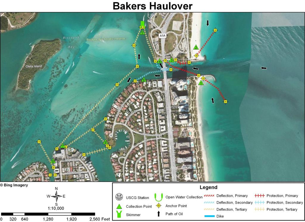
11 INLET SUMMARY SHEET SITE: Bakers Haulover DATE AND TIME OF ORIGINAL FIELD SURVEY [TIDE]: 27 June 1994; (-0.5); Haulover Pier, N. Miami Beach] UPDATED: In October 2011 using imagery collected in 2010 and RANKING (DEGREE OF DIFFICULTY): (see ranking scale) A. PRINCIPAL RESOURCES AT RISK: Manatees present. Seabirds. Marina facilities, boats, and seawalls, revetments, docks, etc. on the shores of Biscayne Bay and other canals and creeks. Sea turtle nesting on sand beaches. For more information consult the recent ESI maps and data and the GRP. PRELIMINARY PROTECTION STRATEGY: Divert oil entering through the marginal flood channels to collection points on the outer sand beaches (CPs 1 and 2). Inside the inlet, anchor a line of deflection boom to a point on the seaward half of the south jetty to divert oil to a collection point against the concrete seawall along the north side of the main inlet channel [just seaward of the Route A1A Bridge (CP3)]. Place a line of protection boom along the riprap to the east of the seawall at CP3 (to half way out the north jetty). Anchor a Christmas tree configuration of deflection boom to the Route A1A Bridge abutment so that the north limb diverts oil to a collection point against the concrete seawall on the north side of the main inlet channel (CP4) and the south limb to the seawall on the south side (CP6). Further inside the inlet, use two lines of deflection boom to divert oil flowing south in Biscayne Bay to a collection point on the seawall along the developed north shore of the eastern Bay Harbor Island (CP7). From eastern shore of Biscayne Bay next to Bal Harbour Yacht Club extend deflection boom northwest about 200 yards (CP9). Also use protection boom to close off the entrance to Indian Creek. Use another short line of deflection boom to divert oil to a seawall on the east shore of the canal that separates the two Bay Harbor Islands (CP8). From CP 4 extend a line of deflection boom to the north about 0.2 miles to an open water skimmer (CP5). A line of deflection boom about 0.8 miles long should be extended along the front of the floodtidal delta (with due care of the bottom topography) that connects the open water skimmer at CP5 126
12 INLET SUMMARY SHEET SITE: Bakers Haulover (continued) PRELIMINARY PROTECTION STRATEGY (continued): and to the seawall at CP7. This deflection boom should be pivoted so that the northern fourth of the line of boom deflects oil to the north (to CP5) and the rest of it deflects oil to the south (to CP7). OTHER COMMENTS: The 1994 NOAA Tidal Current Tables reported that tidal currents in Bakers Haulover Inlet reach 2.9 knots at maximum flood tide and 2.5 knots at maximum ebb tide. 127
13 128

14 Collection Point Description Inlet: Bakers Haulover Site Name: Collection Point #1 Relative Location: Outer beach just south of the south jetty. Latitude: 25 53' " N Longitude: 80 7' " W Currents: 1-3 knots along shore to the north during rising tides. Shoreline Description: Sand beach. Access: This is Bal Harbor Beach Park with a well-built fishing pier along the jetty. Parking is available on other side of A1A Bridge. Probably can drive to near the pier. Walking definitely. Additional Comments: Use caution due to sea turtle nesting in area. 129
15 Collection Point Description Inlet: Bakers Haulover Site Name: Collection Point #2 Relative Location: Outer beach on north side of jetty. Latitude: 25 54' 5.754" N Longitude: 80 7' " W Currents: 1-3 knots along shore to the south during rising tides. Shoreline Description: Sand beach. Access: This is Haulover Beach Park with lots of parking and ready access to the beach. Additional Comments: Use caution due to sea turtle nesting in area. 130
16 Collection Point Description Inlet: Bakers Haulover Site Name: Collection Point #3 Relative Location: On north side of main inlet channel just east of the A1A Bridge. Latitude: 25 54' 2.532" N Longitude: 80 7' " W Water Depth Description: On side of the main inlet channel. Currents: Up to 3 knots to be expected. Shoreline Description: Concrete seawall. Access: Parking area right by seawall. 131

17 Collection Point Description Inlet: Bakers Haulover Site Name: Collection Point #4 Relative Location: On north side of main inlet channel just west of the A1A Bridge. Latitude: 25 54' 2.350" N Longitude: 80 7' " W Water Depth Description: On side of main inlet channel. Currents: Expect up to 3 knot currents. Shoreline Description: Concrete seawall. Access: Paved right up to seawall. 132

18 Collection Point Description Inlet: Bakers Haulover Site Name: Collection Point #5; open water skimmer. Relative Location: Out in water just west of Haulover Beach Park about 0.2 miles north of the main inlet channel. Latitude: 25 54' " N Currents: Possibly up to 2 knots. Shoreline Description: Open water skimmer. Access: By watercraft. Longitude: 80 7' " W 133

19 Collection Point Description Inlet: Bakers Haulover Site Name: Collection Point #6 Relative Location: On south side of main inlet channel to the west of the A1A Bridge. Latitude: 25 53' " N Longitude: 80 7' " W Water Depth Description: On the side of the main inlet channel. Currents: Possibly up to 3 knots. Shoreline Description: Concrete seawall. Access: Densely populated private area with little access by land. Probably should use watercraft. 134
20 Collection Point Description Inlet: Bakers Haulover Site Name: Collection Point #7 Relative Location: North end of the eastern Bar Harbor Island. Latitude: 25 53' " N Longitude: 80 7' " W Currents: Probably around one knot. Shoreline Description: Concrete seawall. Access: Beside a large parking area. 135

21 Collection Point Description Inlet: Bakers Haulover Site Name: Collection Point #8 Relative Location: Northwest end of the eastern Bar Harbor Island. Latitude: 25 53' " N Longitude: 80 8' 3.072" W Currents: Possibly up to one knot. Shoreline Description: Concrete seawall. Access: In a tightly packed private area. Land access may be difficult. May have to use watercraft. 136

22 Collection Point Description Inlet: Bakers Haulover Site Name: Collection Point #9 Relative Location: Eastern Shore of Biscayne Bay next to Bal Harbour Yacht Club. Latitude: 25 53' " N Currents: Possibly up to one knot. Shoreline Description: Seawall. Longitude: 80 8' 3.072" W Access: At the end of Bal Bay Dr. across open field. If permission to access by land is denied use watercraft. 137
Geographic Response Plan Map: EFL-40 ]^4011. ! Manatee [v NERR. National Park. Naval Facility. Piping Plover. Power Plant. Recreational Fishing
![Geographic Response Plan Map: EFL-40 ]^4011. ! Manatee [v NERR. National Park. Naval Facility. Piping Plover. Power Plant. Recreational Fishing](/thumbs/91/105050028.jpg "Geographic Response Plan Map: EFL-40 ]^4011. ! Manatee [v NERR. National Park. Naval Facility. Piping Plover. Power Plant. Recreational Fishing") 29 22'30"N 81 7'30"W!E(! EFL40-01 Basin Bulow Creek State Park Addison Blockhouse Historic State Park NRC - Ormond Beach Warehouse Equipment Site (ID JAX-E8) River Basin k k Marsh Aquatic Preserve!S( 200
29 22'30"N 81 7'30"W!E(! EFL40-01 Basin Bulow Creek State Park Addison Blockhouse Historic State Park NRC - Ormond Beach Warehouse Equipment Site (ID JAX-E8) River Basin k k Marsh Aquatic Preserve!S( 200
Geographic Response Plan Map: VI '0"W A564 - MARY. ( Point. Francis B ay. [ j A56 - CINNAMON. r [ XXX A557 [ Bay AND GREAT LAMESHUR BAYS
 Geographic Response Plan Map: VI-7 500 750 18 22'30"N XXX 800 550 1450 1350 Coral Harbor 650 5 14 0 19 5 0 700 Round 850 0 17 0 Virgin Islands Coral Reef National Monument Ledduck j St. St. n Joh as om
Geographic Response Plan Map: PR-63. B56 - PUERTO DE JOBOS Puerto de MARINA Jobos ! ( de Aguirre. k d A55 - PUNTA. Caribbean Sea
 Geographic Response Plan Map: PR-63 66 7'30W 18 0'0N 18 0'0N 66 15'0W 52 53 Guayama Salinas Bay National Estuary Research Resere NOAA) A53 MAR NEGRO PREPA Aguirre B56 - PUERTO DE JOBOS Puerto e MARINA
Geographic Response Plan Map: CPR-41. Map Continued on PR-42. Terrenos Transferidos Roosevelt Roads XXX. Punta Luna. Acropora Priority Sites
 Geographic Response Plan Map: CPR-41 65 45'0W eiba Map Continue on PR-27 S 65 37'30W 1200 j Puerto Meio Muno Map Continue on PR-40 G C - Protect after B Areas - Lower Priority Natural Collection Areas
BROWARD COUNTY MANATEE PROTECTION ZONES
 MANATEE PROTECTION ZONES For description of zone boundaries see: 68C-22.00 F.A.C for State Manatee Protection Zones last amended /4/20 For infomation please call or write to: Fish and Wildlife Conservation
HARBOR INFRASTRUCTURE INVENTORIES Erie Harbor, PA
 HARBOR INFRASTRUCTURE INVENTORIES Erie Harbor, PA Harbor Location: Erie Harbor is located on the southern shore of Lake Erie in the City of Erie, PA about 98 Miles southwest of Buffalo. Authority: River
Potential Application of. Shore-Stabilizing Structures along an Open-Coast Shoreline. Christopher G. Creed, P.E. 23 rd Annual National Conference on
 23 rd Annual National Conference on Potential Application of Beach Preservation Technology February 3-5, 2010 Indialantic, FL Shore-Stabilizing Structures along an Open-Coast Shoreline Christopher G. Creed,
Access: The rocky shoreline is only accessible via private property.
 10. Whale Cove Site description: Whale Cove is a small cove fringed by private homes and condominiums with diverse and relatively undisturbed rocky intertidal and subtidal habitat located approximately
CityStats Southeast Florida Trends
 CityStats Florida Trends 2018 Research Analyst Liane Giroux, CAE Center for Municipal Research & Innovation Florida League of Cities CityStats Florida Regional Trend Analysis Municipal Revenue Sources
CityStats Southeast Florida Trends
 CityStats Southeast Florida Trends 2017 Research Analyst Liane Schrader, CAE Center for Municipal Research & Innovation Florida League of Cities CityStats Southeast Florida Regional Trend Analysis 100%
Staff Report on Brevard County Area Projects (See pages 32-60) Staff will present a report on District Projects in the Brevard County area.
 Staff will present a report on District Projects in the Brevard County area.") Call to Order - Chair Netts will call the meeting to order. Pledge of Allegiance - Commissioner Sansom will lead the Pledge of Allegiance. Roll Call - Secretary Gernert will call the roll. Additions or
Call to Order - Chair Netts will call the meeting to order. Pledge of Allegiance - Commissioner Sansom will lead the Pledge of Allegiance. Roll Call - Secretary Gernert will call the roll. Additions or
Title/Name of the area: Chwaka Bay, Zanzibar
 Title/Name of the area: Chwaka Bay, Zanzibar Presented by: Dr. Charles Lugomela, Ag. Head, Department of Aquatic Sciences and Fisheries, University of Dar es Salaam, P.O. Box 35064 Dar es Salaam, Tanzania
PORT EVERGLADES SAND BYPASS PROJECT
 28 th Annual National Conference on Beach Preservation Technology February 4, 2015 Clearwater Beach, FL PORT EVERGLADES SAND BYPASS PROJECT AN IMPORTANT FUTURE SAND SOURCE FOR SOUTHEAST FLORIDA BEACHES
Virginian Atlantic (Ecoregion 8)
") Virginian Atlantic (Ecoregion 8) Background The Virginian Atlantic Ecoregion extends from the south side of Cape Cod to Cape Hatteras in North Carolina. The waters of the ecoregion are a mix of cold and
Virginian Atlantic (Ecoregion 8) Background The Virginian Atlantic Ecoregion extends from the south side of Cape Cod to Cape Hatteras in North Carolina. The waters of the ecoregion are a mix of cold and
Geographic Response Plan Map: PR-12. Atlantic Ocean B3 - DOS HERMANOS CONDADO LAGOON. ar t. Reserva Natural Cano Martin Pena
 Geographic Response Plan Map: PR-12 18 30'0"N 66 0'0"W 18 30'0"N 66 7'30"W Atlantic Ocean B1 - EL MORRO San AND SAN Cristobal CRISTOBAL XX Punta el Morro e æ SAN e 150 200 150 200 250 250 JUAN 25 300 s
U. S. Coast Guard Sector Boston. November 2016 April 2017
 U. S. Coast Guard Sector Boston November 2016 April 2017 Pollution Statistics for Port of Boston NOV 2016 APR 2017 Reports Received: 38 OSLTF funded responses: 4 Amount Discharged (water & land impact):
MARTIN COUNTY MANATEE PROTECTION ZONES
 MANATEE PROTECTION ZONES For description of zone boundaries see: 68C-22.024 F.A.C for State Manatee Protection Zones last amended 2/24/990 For infomation please call or write to: Fish and Wildlife Conservation
The History & Management of the Atlantic Intracoastal Waterway in Florida
 The History & Management of the Atlantic Intracoastal Waterway in Florida THE BEGINNING OF THE INTRACOASTAL WATERWAY IN FLORIDA CONSTRUCTED BY A PRIVATE COMPANY, THE FLORIDA EAST COAST CANAL COMPANY BETWEEN
Port Everglades Master/Vision Plan Update
 Port Everglades Master/Vision Plan Update Environmental Stakeholder Meeting June 15, 2009 Discussion to Focus On: Updating the 2006 Port Everglades Master Plan Issues dealing with the Turning Notch Potential
U.S. Activities in Puerto Rico, U.S. Virgin Islands and the Wider Caribbean. NOAA and the US Coral Reef Task Force
 U.S. Activities in Puerto Rico, U.S. Virgin Islands and the Wider Caribbean NOAA and the US Coral Reef Task Force U.S. Coral Reef Task Force Co-Chairs: National Oceanic and Atmospheric Administration (NOAA)
Gary Cohen BH3. Admiral s Port. The Courtyards. Commodore Plaza. Island Estates. Trump Hollywood. Terra Beachside 6000 Collins.
 BH3 Led by principals Gregory Freedman, Charles Phelan and Daniel Lebensohn, BH3 is an opportunistic real estate firm with a core focus on acquiring real estate in South Florida and New York City. In addition
Restoration History Of Anitra Thorhaug, Phd.
 Restoration History Of Anitra Thorhaug, Phd.. 1.) FIRST LARGE SCALE SEAGRASS RESTORATION. Nuclear Power Plant. Turkey Point, Biscayne Bay, Florida after the plant went to an alternate cooling system 2.)
Miami/Ft. Lauderdale
 004030 - Miami/Ft. Lauderdale Description: I-95 ES 300ft S/O Coral Way F/N - 1 TAB Panel ID: 7402708 City: MIAMI Latitude: 25.761 Media Type: Bulletin State: FL Longitude: -80.199 Dimensions: 48' x 10'
1. Overview of Atlantic Highlands and Its Waterfront
 Atlantic Highlands 1. Overview of Atlantic Highlands and Its Waterfront Atlantic Highlands: Satellite Photo by USGS 1.1. Geographical Overview The Borough of Atlantic Highlands is on Sandy Hook Bay. It
Flagler County Manatee Protection Plan
 Flagler County Manatee Protection Plan Prepared by: Flagler County Board of County Commissioners 1769 East Moody Boulevard Bunnell, FL 32110 386.313.4000 Technical Assistance by: Atlantic Ecological Services,
Welcome to Marco Island
 Marco Island is located in Southwest Florida, on the Gulf of Mexico, 178 miles south of Tampa,16 miles south of Naples, and 104 miles due west of Miami. Marco is the northern most and largest of the famous
Miami/Ft. Lauderdale
 010018 - Miami/Ft. Lauderdale Description: I-95 WS 0.2mi S/O Stirling Rd F/S - 1 TAB Panel ID: 355514 City: HOLLYWOOD Latitude: 26.045 Media Type: Bulletin State: FL Longitude: -80.163 Dimensions: 19'
1. Overview of Aberdeen Township and Its Waterfront
 Aberdeen 1. Overview of Aberdeen Township and Its Waterfront 1.1 Geographic Overview Aberdeen Township is a suburban township with a land area of 5.45 square miles, with about 2 miles of shoreline along
2010 CHICAGO YACHT CLUB RACE TO MACKINAC LAKE MICHIGAN HARBOR CONTACT INFORMATION
 2010 CHICAGO YACHT CLUB RACE TO MACKINAC LAKE MICHIGAN HARBOR CONTACT INFORMATION On your return trip from Mackinac Island, you will likely want to go at a more leisurely pace, stopping in different harbors
Miami/Ft. Lauderdale
 001583 - Miami/Ft. Lauderdale Description: Florida Turnpike WS 0.6mi E/O US Hwy 1 F/N - 2 TAB Panel ID: 354432 Media Type: Digital Dimensions: 10'6" x 36' City: FLORIDA CITY State: FL Zip: 33034 Latitude:
THE BULGARIAN SEASHORE The Perfect Place for Business & Tourism
 THE BULGARIAN SEASHORE The Perfect Place for Business & Tourism Gary Groenewold Vice President, Westrec Marinas, Intl. Director, Super Yacht Society Licensed Mega-Yacht Captain American Boat Builders and
Bazaruto Archipelago National Park-Mozambique. Mozambique. Workshop on MPAs- Is MPAs a useful tool In Fisheries management?
 Bazaruto Archipelago National Park-Mozambique Workshop on MPAs- Is MPAs a useful tool In Fisheries management? Norway ; 24-25 25 October 2006 By Paula Santana Afonso Institute for Fisheries Research Mozambique
Stone Harbor Municipal Public Access Plan. in accordance with N.J.A.C. 7:7E
 Stone Harbor Municipal Public Access Plan in accordance with N.J.A.C. 7:7E December 2011 Stone Harbor Municipal Public Access Plan EXECUTIVE SUMMARY In the spring of 2011, the New Jersey Department of
City of Fort Lauderdale. Frequently Asked Questions. Proposed Sea Wall Ordinance
 City of Fort Lauderdale Frequently Asked Questions Proposed Sea Wall Ordinance The City of Fort Lauderdale is considering amending the Unified Land Development Regulations of the City of Fort Lauderdale
Needs for UAS in Response
 UAS Potential Uses and Limitations October 21, 2015 Michele Jacobi Office Response and Restoration 10/27/2015 1 Needs for UAS in Response Limited access to areas of interest (distance, safety concerns,
Unit 1 Lesson 1: Introduction to the Dry Tortugas and Sustainable Seas Expedition
 Unit 1 Lesson 1: Introduction to the Dry Tortugas and Sustainable Seas Expedition Lesson Objectives: Introduce students to the historical, geographic, and ecological importance of the Dry Tortugas. Introduce
Toll Rates for Florida Turnpike System and Florida Department of Transportation (FDOT) Toll Facilities. South Florida
 Toll Facilities. South Florida") Toll Rates for Florida Turnpike System and Florida Department of Transportation (FDOT) Toll Facilities South Florida Effective: October 29, 207 S.R. 82 (HEFT) Miami-Dade and Broward Counties S.R. 82 (HEFT)
Toll Rates for Florida Turnpike System and Florida Department of Transportation (FDOT) Toll Facilities South Florida Effective: October 29, 207 S.R. 82 (HEFT) Miami-Dade and Broward Counties S.R. 82 (HEFT)
TOWARDS SUSTAINABLE MANAGEMENT OF MARINE AND COASTAL HABITATS ASIA- PACIFIC DAY FOR THE OCEAN
 TOWARDS SUSTAINABLE MANAGEMENT OF MARINE AND COASTAL HABITATS WANNAKIAT THUBTHIMSANG PHUKET MARINE BIOLOGICAL CENTER, DMCR, THAILAND ASIA- PACIFIC DAY FOR THE OCEAN 20 NOVEMBER 2018, CONFERENCE ROOM 4,
HARBOR INFRASTRUCTURE INVENTORIES Buffalo Harbor, New York
 HARBOR INFRASTRUCTURE INVENTORIES Buffalo Harbor, New York Harbor Location: Buffalo Harbor is located on the Eastern shore of Lake Erie in the City of Buffalo, NY. Authority: River & Harbor Acts of 1826,
COUNTIES AND COMMUNITIES SERVED COUNTIES COMMUNITIES
 Peoples Gas System First Revised Sheet No. 6.101 a Division of Tampa Electric Company Cancels Original Sheet No. 6.101 AND SERVED *Bay Broward Charlotte *Callaway *Cedar Grove *Lynn Haven *Panama City
25150 SW 227 th AVENUE Homestead, FL 33031
 25150 SW 227 th AVENUE Homestead, FL 33031 5 Acres $223,900.00 Telephone: 954-224-6111 email: CLF@Comfortrealtycorp.com www.comfortrealtycorp.com WHISPER WALK ESTATES 5 ACRE TRACT Tel: 954 224 6111 * email:
Water Resources Update after NCGA Long Session
 Water Resources Update after NCGA Long Session North Carolina Beach Inlet & Waterway Association Annual Conference November 16, 2015 Division of Water Resources Overview New Name / Reorganization Jordan
Project A: Revetment Scale: 1 = 10. 3/7 Revision: Benchmarks. Eroding Parking Area. View from Above. Locklies Creek. Ebb.
 Project A: Revetment Scale: 1 = 10 View from Above Floating Dock 3/7 Revision: Benchmarks 34 Locklies Creek Ebb Flood E. 18x8 Floating Dock Channelward of Vegetation 30 Class A1A Rip Rap MLW MHW 57 1 4
Aid to Local Ports FY19 Requests
 City Accomack- Greenbackville Harbor Phase III Accomack-Quinby Harbor Bulkhead Cape Charles- Installation of 4 th breakwater Total Project Cost Amount Requested Proposed Allocation Carryover Request $260,000.00
Miami/Ft. Lauderdale
 002680 - Miami/Ft. Lauderdale Description: US 1 WS 100ft S/O Bird Rd F/S - 1 TAB Panel ID: 354556 City: MIAMI Latitude: 25.734 Media Type: Bulletin State: FL Longitude: -80.252 Display Dimensions: 14'
Underwater Acoustic Monitoring in US National Parks
 Underwater Acoustic Monitoring in US National Parks Megan F McKenna 1, Christopher Garsha 2, Erik Stabenau 1, Christine Gabriele 1, Timothy Clark 1, Clayton Pollock 1, Brinnen Carter 1, Samantha Bietsch
VOLUME II APPENDIX F DETAILED PHYSICAL DESCRIPTION OF PROJECT RESERVOIRS AND LANDS
 VOLUME II APPENDIX F DETAILED PHYSICAL DESCRIPTION OF PROJECT RESERVOIRS AND LANDS THE CENTRAL NEBRASKA PUBLIC POWER AND IRRIGATION DISTRICT FERC PROJECT NO. 1417 PHYSICAL DESCRIPTION OF PROJECT LANDS
Engineering With Nature Geographic Project Mapping Tool (EWN ProMap)
") Engineering With Nature Geographic Project Mapping Tool (EWN ProMap) Cynthia Banks Program Manager Burton Suedel, PhD Research Biologist Michelle Bourne Research Biologist U.S. Army ERDC 23 June 2015 Dredging
Engineering With Nature Geographic Project Mapping Tool (EWN ProMap) Cynthia Banks Program Manager Burton Suedel, PhD Research Biologist Michelle Bourne Research Biologist U.S. Army ERDC 23 June 2015 Dredging
How South Africa is making progress towards the Aichi 2020 Target 11
 How South Africa is making progress towards the Aichi 2020 Target 11 Montreal, Canada 2 May 2016 Oceans and Coasts Content Protected area considerations and progress 1994-2010 Terrestrial Protected Area
MARINE PROTECTED AREAS LESSON PLAN Water Parks
 Marine Protected Areas U. S. Marine Protected Areas Lesson Plan MARINE PROTECTED AREAS LESSON PLAN Water Parks Theme U.S. Marine Protected Areas Links to Overview Essays and Resources Needed for Student
FOR SALE INDIAN OCEAN BEACHFRONT- HEADLAND PLOT
 June 2017 FOR SALE INDIAN OCEAN BEACHFRONT- HEADLAND PLOT Rasini, Kimbiji, Kizito Huonjwa, Temeke, Dar es Salaam, Tanzania A UNIQUE opportunity to acquire 9 hectares/22 acres of natural cliff and beachfront
NATIONAL PARKS IN PERIL
 NATIONAL PARKS IN PERIL THE THREATS OF CLIMATE DISRUPTION State Fact Sheet: Florida Human disruption of the climate is the greatest threat ever to our national parks. At risk are nearly every resource
50 Largest U.S. Metropolitan Areas
 America s Racially : Opportunities and Challenges 50 Largest U.S. Metropolitan Areas Community types in the 50 largest metropolitan areas 39,333,003 % 14,533,3 16,983,337 9% 10% 47,406,687 49,199,197 30,180,578
Analysis and Feasibility Broward County Convention Center Master Plan Study Fort Lauderdale, FL HKS I Urban Design Studio
 Analysis and Feasibility Broward County Convention Center Master Plan Study Fort Lauderdale, FL 04.01.14 HKS I Urban Design Studio Summary of Outreach Purpose of Stakeholder Outreach Identify and engage
East Coast Greenway (ECG) Southeast Region Miami-Dade/Broward/Palm Beach/Martin/St. Lucie/Indian River
 Southeast Region Miami-Dade/Broward/Palm Beach/Martin/St. Lucie/Indian River") East Coast Greenway (ECG) Southeast Region Miami-Dade/Broward/Palm Beach/Martin/St. Lucie/Indian River What is the ECG/SE Region? Connects Key West to Maine 220 miles Indian River to Miami-Dade County
East Coast Greenway (ECG) Southeast Region Miami-Dade/Broward/Palm Beach/Martin/St. Lucie/Indian River What is the ECG/SE Region? Connects Key West to Maine 220 miles Indian River to Miami-Dade County
Alaskan/Fjordland Pacific (Ecoregion 22)
") Alaskan/Fjordland Pacific (Ecoregion 22) Background The Alaskan/Fjordland Pacific Ecoregion is an area of abundant marine resources. The ecoregion begins at Vancouver Island and moves up the Gulf of Alaska
Alaskan/Fjordland Pacific (Ecoregion 22) Background The Alaskan/Fjordland Pacific Ecoregion is an area of abundant marine resources. The ecoregion begins at Vancouver Island and moves up the Gulf of Alaska
Anchoring Conflicts on Florida s Waterways
 Slide 1 Anchoring Conflicts on Florida s Waterways A Case Study Florida Fish and Wildlife Conservation Commission Division of Law Enforcement Boating and Waterways Section Slide 2 Anchoring in Florida
Tufts University Water: Systems, Science, and Society (WSSS) Program
 Program") To: From: John Foster, Elbow Cay, the Bahamas; Friends of the Environment, Marsh Harbor, the Bahamas Alex Bedig, Amanda Garfield, Shonda Gaylord, Jack Melcher, Melissa Ng, Nathan Rawding, Kendall Webster,
To: From: John Foster, Elbow Cay, the Bahamas; Friends of the Environment, Marsh Harbor, the Bahamas Alex Bedig, Amanda Garfield, Shonda Gaylord, Jack Melcher, Melissa Ng, Nathan Rawding, Kendall Webster,
Waterway Access and the Atlantic Intracoastal Waterway in Florida
 Waterway Access and the Atlantic Intracoastal Waterway in Florida Issues: Maintenance - Funding (costs), Infrastructure needs, permitting Management Consideration of the M-95 system, Cooperation among
ALASKA RRT. Arctic & Western Alaska Area Committee Brief March 5, 2019
 ALASKA RRT Arctic & Western Alaska Area Committee Brief March 5, 2019 AREA COMMITTEE UPDATE Notable Events within Area Committee: 5 Subcommittees met and began work on OSC tasking Workgroups formed underneath
FLORIDA DIVISION OF EMERGENCY MANAGEMENT STATE WATCH OFFICE DAILY INCIDENT REPORT
 FLORIDA DIVISION OF EMERGENCY MANAGEMENT STATE WATCH OFFICE DAILY INCIDENT REPORT Incident Number: 2019-354 Incident Name: Traffic Crash with Diesel Spill Occurred: 1/18/2019 23:13 ET Reported to SWO:
Ports. Water and Environment Solutions
 Ports Water and Environment Solutions BMT WBM in Ports The Company BMT WBM and Ports BMT WBM Pty Ltd is a leading edge water and environmental consultancy with more than 40 years national and international
BrowardNEXT Topic Item Web Link Source Year
 BrowardNEXT Topic Item Web Link Source Year Intergovernmental Coordination Population QuickFacts http://www.census.gov/quickfacts/table/pst120 US Census Bureau 2010 214/12011 Intergovernmental Coordination
HARBOR INFRASTRUCTURE INVENTORIES Cleveland Harbor, OH
 HARBOR INFRASTRUCTURE INVENTORIES Cleveland Harbor, OH Harbor Location: Cleveland Harbor is located at the mouth of the Cuyahoga River on the southern shore of Lake Erie in the city of Cleveland, OH. Authority:
Elkhorn Slough Tidal Wetland Project
 Elkhorn Slough Tidal Wetland Project Joint Meeting Strategic Planning Team and Science Panel September 23, 2009 Funding National Oceanic and Atmospheric Admin. David and Lucille Packard Foundation Resources
CHAPTER 4 -- THE LAND USE PLAN: DESCRIPTIONS AND POLICIES FOR THIRTEEN PLANNING AREAS
 CHAPTER 4 -- THE LAND USE PLAN: DESCRIPTIONS AND POLICIES FOR THIRTEEN PLANNING AREAS NORTH CENTRAL CAC PLANNING AREA 4.4 FORT BRAGG CITY LIMIT TO HARE CREEK PLANNING AREA (Includes Noyo) The Noyo community
REVISED: 3/3/2017 3:16:04 PM
 CITY ZIP AREA CITY ZIP AREA ATLANTIS KENDALL 33156 C AVENTURA 33160 C KEY BISCAYNE 33149 C BAL HARBOUR 33154 C LAKE CLARKE SHORES BAL HARBOUR ISLDS 33154 C LAKE PARK 33403 BISCAYNE PARK 33161 B LAKE WORTH
Site description: 2.7 miles of intertidal habitat located about 2 miles north of Depoe Bay in Lincoln County, Oregon (Figure 16).
.") 8 Boiler Bay Site description: 27 miles of intertidal habitat located about 2 miles north of Depoe Bay in Lincoln County, Oregon (Figure 16) Designation: Boiler Bay was a research reserve before TSP publication,
8 Boiler Bay Site description: 27 miles of intertidal habitat located about 2 miles north of Depoe Bay in Lincoln County, Oregon (Figure 16) Designation: Boiler Bay was a research reserve before TSP publication,
October 7, 2016 Hurricane Matthew Rakes the East Coast of Flagler County for 18.1 Miles
 October 7, 2016 Hurricane Matthew Rakes the East Coast of Flagler County for 18.1 Miles Hammock Dunes Suffers Penetration of the Ocean into the Community; has a 15-30 ft. Wide Triangular Section of the
APPENDIX A TERMS OF DESIGNATION
 247 248 ABOUT THIS DOCUMENT On May 11, 1994 the National Oceanic and Atmospheric Administration (NOAA) published the final Olympic Coast National Marine Sanctuary Regulations (59 FR 24586). This official
Section 4 / Rev Page 1 of 5
 Section 4 / Rev.6.0 2011-12-31 Page 1 of 5 Section 4 / Rev.6.0 2011-12-31 Page 2 of 5 AES Andres Latitude: 18º 24,4 N Longitude: 069º 37,6 W D.R: Chart 008 B.A. Chart 467 D.M.A. Chart 25849 Plan A Admiralty
Keansburg: Satellite Photo by USGS. Township of Middletown, and the western tip of Keansburg is adjacent to the Borough of
 Keansburg 1. Overview of Keansburg and Its Waterfront Keansburg: Satellite Photo by USGS 1.1 Geographical Overview The Borough of Keansburg is one of nine communities that comprise the Bayshore Region
Clam Harbour Provincial Park
 Clam Harbour Provincial Park Public Engagement Session Thursday, September 14 th, 2017 5:30pm 7:30pm Webbers Store 11470 Nova Scotia Trunk 7 Lake Charlotte, NS Agenda Overview of the Provincial Parks System
CHAPTER FIVE ENVIRONMENTAL CONSEQUENCES
 CHAPTER FIVE ENVIRONMENTAL CONSEQUENCES Pursuant to the environmental documentation requirements of FAA Order 1050.1E, Environmental Impacts, Policies and Procedures, this chapter describes the reasonably
NATIONAL PARK SERVICE LANDS / JURISDICTIONS ANNEX TO THE SAVANNAH CAPTAIN OF THE PORT ZONE AREA CONTINGENCY PLAN
 NATIONAL PARK SERVICE LANDS / JURISDICTIONS ANNEX TO THE SAVANNAH CAPTAIN OF THE PORT ZONE AREA CONTINGENCY PLAN Fort Pulaski National Monument Fort Frederica National Monument Cumberland Island National
Project Update to Treasure Coast Regional Planning Council
 S o u t h F l o r i d a E a s t C o a s t C o r r i d o r ( S F E C C ) S t u d y Project Update to Treasure Coast Regional Planning Council December 14, 2012 M I A M I - D A D E, B R O W A R D, A N D
Broward County Land Use Plan: Environmentally Sensitive Lands
 US27 HIATUS RD NW 136TH AVE SW 136TH AVE FLAMINGO RD LYONS RD CYPRESS RD Broward County Land Use Plan: Environmentally Sensitive Lands PALM BEACH COUNTY N USHY 27 284939 334939 045039 095039 44 CONSERVATION
MATTHEW G. MCALLISTER Director (561)
") SOUTH FLORIDA INDUSTRIAL TEAM CUSHMAN & WAKEFIELD AVAILABLE PROPERTIES February 2017 CUSHMAN & WAKEFIELD 515 E. Las Olas Boulevard, Suite 860 Fort Lauderdale, FL 33301 225 NE Mizner Boulevard, Suite 300
SOUTH FLORIDA INDUSTRIAL TEAM CUSHMAN & WAKEFIELD AVAILABLE PROPERTIES February 2017 CUSHMAN & WAKEFIELD 515 E. Las Olas Boulevard, Suite 860 Fort Lauderdale, FL 33301 225 NE Mizner Boulevard, Suite 300
STORNETTA BROTHERS COASTAL RANCH
 STORNETTA BROTHERS COASTAL RANCH Location: Surrounding Point Arena Lighthouse and immediately south of Manchester State Park Mendocino Co., CA Acres: 1,860 Resources: Over two miles of Pacific Ocean coastline
FY Annualized. FY Annualized
 REVENUE ESTIMATING CONFERENCE TAX: Stormwater Fees ISSUE: Stormwater Fees for Agricultural Lands BILL NUMBER(S): HB 1197 enrolled Sec 1 SPONSOR(S): State Affairs Committee; Representative Horner MONTH/YEAR
SITE & BUILDING ANALYSIS
 SITE & BUILDING ANALYSIS Crandon Park 4000 Crandon Boulevard Key Biscayne, Florida MYLENE FENG MIAMI I95 Virginia Key Crandon Boulevard 913 Map of Key Biscayne KEY BISCAYNE LANDMARKS & TOURIST ATTRACTIONS
Guide to Pinellas County. Blueways. Prepared by THE PINELLAS COUNTY PLANNING DEPARTMENT December, 2006
 Guide to Pinellas County Blueways Prepared by THE PINELLAS COUNTY PLANNING DEPARTMENT December, 2006 P inellas County has miles of beautiful shoreline, providing paddlers with a variety of opportunities
 BROWARD DEANERY 1 ALL SAINTS (954) 467-6496 333 Tarpon Dr. Ft. Lauderdale, FL 33301 4 INTERCESSION (954) 763-5986 501 N.W. 17 St. Ft. Lauderdale, FL 33311 I-95 to Broward Blvd. exit. Go east on Broward
Appendix Table C-1 Visitor Boater Survey Site Count Number of Surveys Completed at Each Site - By County
 Appendix Table C-1 Completed at Each Site - By County MONROE County Sites 3 Blank 15 50 America Outdoors 1 51 Anne's Beach 12 52 Atlantic Shores Resort 1 53 Bahia Honda Beach & State Park 48 54 Banana
Schedule ROUTE. All Week. Broward County Transit
 For more details on our fares please visit our web site at Broward.org/BCT or call customer service: 954.357.8400. Reading A Timetable - It s Easy. The map shows the exact bus route. 2. Major route intersections
City of Doral Flood Warning and Response Plan
 City of Doral Flood Warning and Response Plan Prepared by: City of Doral Public Works Department Stormwater Division City of Doral Flood Warning and Response Plan Flood events tend to pose a variety of
Kirkcaldy Sea Wall Improvements. Non-technical Summary. For illustration purposes only to give an indicative representation of the scheme.
 ENVIRONMENTAL STATEMENT Non-technical Summary For illustration purposes only to give an indicative representation of the scheme. Kirkcaldy Sea Wall Improvements Introduction A concrete sea wall fronts
A1A North Corridor Multi-Use Trail. Vilano to Ponte Vedra Beach
 A1A North Corridor Multi-Use Trail Vilano to Ponte Vedra Beach The A1A North Corridor Community Area comprised of five unincorporated areas: Porpoise Point Vilano Beach Surfside Beach North Beach South
Deering Estate Camp. Field Trip total: $ 5.00 Monday Tuesday Wednesday Thursday Friday. Campers will explore
 Discover Deering Campers will dive into the mission of the Deering Estate which is dedicated to preserving and protecting the natural, archaeological, architectural and historic legacy of the land. WEEK
Action Recommendation: Budget Impact:
 Submitted By City of Fayetteville Staff Review Form 2018-0344 Legistar File ID 7/17/2018 City Council Meeting Date - Agenda Item Only N/A for Non-Agenda Item Byron Humphry 6/29/2018 PARKS & RECREATION
Effects of Groundwater on Salinity in Biscayne Bay
 Effects of Groundwater on Salinity in Biscayne Bay Sarah Bellmund1, Greg Graves2, Steve Krupa2, Herve Jobert3, Greg Garis1, and Steve Blair4 1Biscayne National Park Salinity Monitoring Program, Biscayne
Tri-Rail Coastal Link Project Update
 Exhibit 3 Tri-Rail Coastal Link Project Update Presented to: FTA Region IV December 16, 2013 Agenda Review of Project Activities Next Steps Discussion 2 Review of Project Activities Rebranded project to
Lake Tahoe Shoreline Plan 03 Policy Topic: Access Issues
 Lake Tahoe Shoreline Plan 03 Policy Topic: Access Issues V9 Last Updated 03.10.2017 1 Brief Description Physical access to the waters of Lake Tahoe is one of the key issues surrounding the Shoreline Plan
The MPA Name. The past and future of the. Montego Bay Marine Park Trust
 The MPA Name The past and future of the Montego Bay Marine Park Trust Park Boundaries and Sanctuary Area 100m/330ft/50 Fathom Depth Contour to The Average Highest High Tide Mark 50 Fathom/100M Depth Great
The Regional Coral Reef Task Force and Action plan. 27 th ICRI. Cairns Australia July 2012
 The Regional Coral Reef Task Force and Action plan 27 th ICRI Cairns Australia July 2012 Western Indian Ocean Region East Africa mainland states Indian Ocean Islands states Biogeographic division of the
FAA RECORD OF DECISION. Appendix D FINAL EIS ADDENDUM DOCUMENTS
 FORT LAUDERDALE-HOLLYWOOD INTERNATIONAL AIRPORT FAA RECORD OF DECISION Appendix D FINAL EIS ADDENDUM DOCUMENTS This appendix contains information that has been identified as having been inadvertently omitted
Forth Ports Limited. Ruling Depths & Under Keel Clearances
 Forth Ports Limited - Forth Vessels are scheduled into / out of ports on the Forth & Tay in accordance with the under keel clearance criteria specified in this section of the Marine Guidelines & Port Information.
Pinellas County Environmental Lands
 Pinellas County Environmental Lands In addition to traditional parks and recreation facilities, Pinellas County owns and manages a system of environmental lands that provides specialized resource-based
Marine Exchange of Alaska Port of Juneau Navigation Study
 Safe, Secure, Efficient and Environmentally Responsible Maritime Operations 1000 Harbor Way, Juneau, Alaska 99801 Ph: (907) 463-2607 December 10, 2008 Mr. John Stone Port Director City of Juneau 155 S.
IMPACTS OF THE RECENT TSUNAMI ON THE BUNDALA NATIONAL PARK THE FIRST RAMSAR WETLAND IN SRI LANKA
 IMPACTS OF THE RECENT TSUNAMI ON THE BUNDALA NATIONAL PARK THE FIRST RAMSAR WETLAND IN SRI LANKA by C.N.B. Bambaradeniya, IUCN The World Conservation Union, Sri Lanka Country Office (Email: cnb@iucnsl.org)