NEGATIVE DECLARATION. NAME OF PROJECT: Fresno County Airport Land Use Compatibility Plan (ALUCP)
|
|
|
- Shanon Hodges
- 5 years ago
- Views:
Transcription
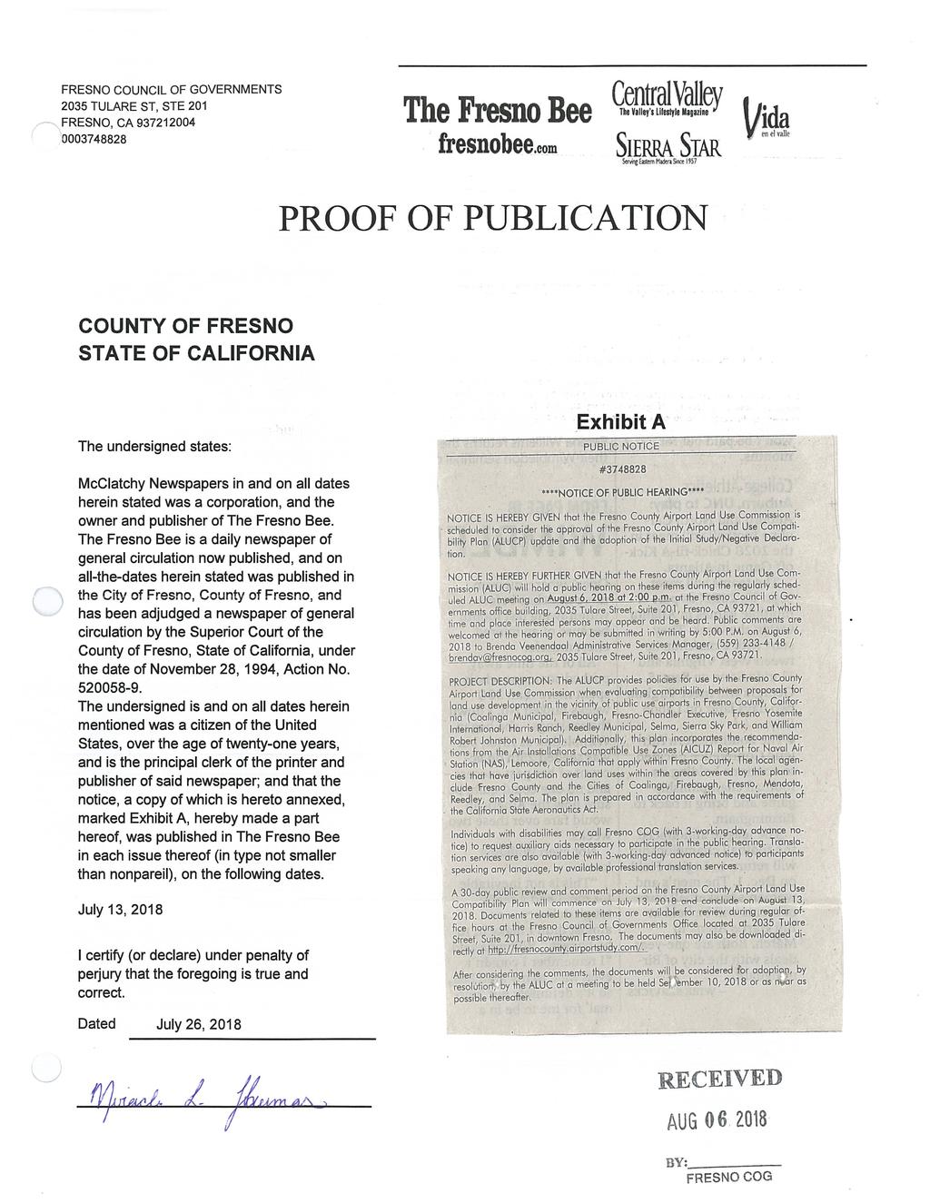
1 Negative Declaration Fresno County ALUCP December 3, 2018 NEGATIVE DECLARATION The Fresno County Airport Land Use Commission (ALUC) has reviewed the proposed project described below to determine whether it could have a significant effect on the environment. Significant effect on the environment means a substantial, or potentially substantial, adverse change in any of the physical conditions within the area affected by the project including land, air, water, minerals, flora, fauna, ambient noise, and objects of historic or aesthetic significance. NAME OF PROJECT: Fresno County Airport Land Use Compatibility Plan (ALUCP) PROJECT DESCRIPTION: The ALUCP provides policies for use by the Fresno County ALUC when evaluating the compatibility between proposals for land use development in the vicinity of the public use airports in Fresno County, California (Coalinga Municipal, Firebaugh, Fresno-Chandler Executive, Fresno Yosemite International, Harris Ranch, Reedley Municipal, Selma, Sierra Sky Park, and William Robert Johnston Municipal). Additionally, this plan incorporates the recommendations from the Air Installations Compatible Use Zones (AICUZ) Report for Naval Air Station (NAS), Lemoore, California that apply within Fresno County. The local agencies that have jurisdiction over land uses within the areas covered by this plan include Fresno County and the Cities of Coalinga, Firebaugh, Fresno, Mendota, Reedley, and Selma. The plan is prepared in accordance with the requirements of the California State Aeronautics Act. PROJECT LOCATION & ENVIRONMENTAL SETTING: The Draft Final Fresno County ALUCP applies to land within the Airport Influence Area (AIA) boundary for each airport: Coalinga Municipal Airport (C80) Appendix A, Exhibit A1 Firebaugh Airport (F34) Appendix B, Exhibit B1 Fresno-Chandler Executive Airport (FCH) Appendix C, Exhibit C1 Fresno Yosemite International Airport (FAT) Appendix D, Exhibit D1 Harris Ranch Airport (3O8) Appendix E, Exhibit E1 Reedley Municipal Airport (O32) Appendix F, Exhibit F1 Selma Airport (0Q4) Appendix G, Exhibit G1 Sierra Sky Park Airport (E79) Appendix H, Exhibit H1 William Robert Johnston Municipal Airport (M90) Appendix J, Exhibit J1 Naval Air Station Lemoore (NLC) Appendix K, Exhibit K1 The AIA boundary was established using the outer boundary of the 14 CFR Part 77 Conical Surface for the following airports: Firebaugh Airport, Fresno-Chandler Executive Airport, Harris Ranch Airport, Reedley Municipal Airport, Selma Airport, Sierra Sky Park Airport, and William Page 1 of 4
2 Negative Declaration Fresno County ALUCP December 3, 2018 Robert Johnston Municipal Airport. 14 CFR Part 77 defines a series of airspace boundaries around an airport to determine if there are obstructions to air navigation. The Conical Surface is the outer boundary of the 14 CFR Part 77 airspace boundaries and generally represents the traffic pattern for an airport. For Coalinga Municipal Airport and Fresno Yosemite International Airport, the AIA includes the Conical Surface, Outer Approach Transitional Surface, and the Precision Approach Surface. The Outer Approach Transitional Surface and Precision Approach Surface are used at airports with runways with a Precision Instrument Approach. The AIA boundary for Naval Air Station Lemoore is based upon the outer boundary of the Imaginary Surfaces for Class B Fixed Wing Runways and noise exposure contours as described in the November 2010 AICUZ report prepared by the United States Navy. APPLICANT CONTACT INFORMATION: Copies of the Negative Declaration, the Initial Study, and the Draft ALUCP may be obtained from the Fresno Council of Governments, 2035 Tulare Street, Suite 201, Fresno, CA FINDINGS AND DETERMINATION: The Fresno County ALUC finds that, based on the completed Initial Study (attached), there is no substantial evidence the project described above will have a significant impact on the environment. Therefore, the following environmental determinations have been made: 1. Based on the whole record (including the Initial Study and any supporting documentation), the Fresno County ALUC has determined that there is no substantial evidence that the project will have a significant effect on the environment. 2. The Negative Declaration, with its supporting documentation, reflects the independent judgment and analysis of the lead agency, which is the Fresno County ALUC. The basis for this determination is that there are no physical construction projects that would result from the adoption of the Fresno County ALUCP or from subsequent implementation of the land use restrictions and policies. In addition, the proposed ALUCP does not reduce or inhibit the development beyond what is depicted on the airport layout plans or diagrams or proposed in the current general plans for Fresno County and the Cities of Coalinga, Firebaugh, Fresno, Mendota, Reedley, and Selma. Current zoning within Fresno County and the Cities of Coalinga, Firebaugh, Fresno, Mendota, Reedley, and Selma are also unaffected by the proposed ALUCP. If there are substantial changes that alter the character or impacts of the proposed project, another environmental impact determination will be necessary. Circulated on: Adopted on: Page 2 of 4
3 Negative Declaration Fresno County ALUCP December 3, 2018 Attachments: A. Public Notice B. Initial Study C. Regional Location Map D. Comments Received and Response PUBLIC REVIEW DISTRIBUTION Copies or notice of this Negative Declaration were distributed to: CALTRANS City of Coalinga City of Firebaugh City of Fresno City of Mendota City of Reedley City of Selma Fresno County State of California Clearinghouse PUBLIC REVIEW (X) Draft document referred for comments on July 13, 2018 (Notice of Public Hearing) and October 26, 2018 (Posted at the Fresno County Clerk s Office). ( ) No comments were received during the public review period. (X) Comments were received but did not address the draft Negative Declaration findings or the accuracy/completeness of the Initial Study. No response is necessary. The letters are attached. ( ) Comments addressing the findings of the draft Negative Declaration and/or accuracy or completeness of the Initial Study were received during the public review period. The letters and responses follow (see Response to Comments, attached). Page 3 of 4
4 Attachment A Public Notice
5
6 October 26, 2018 PUBLIC NOTICE INTENT TO ADOPT AN INITIAL STUDY AND NEGATIVE DECLARATION Fresno Council of Governments has completed and independently reviewed an Initial Study and has prepared an Initial Study/Negative Declaration for the update to the Airport Land Use Compatibility Plan (ALUCP) Update for the Fresno County Airport Land Use Compatibility Plan (ALUCP) update. Project Title: Fresno County Airport Land Use Compatibility Plan (ALUCP) Project Sponsor: Fresno Council of Governments (Fresno COG) Project Description: The ALUCP provides policies for use by the Fresno County ALUC when evaluating the compatibility between proposals for land use development in the vicinity of the public use airports in Fresno County, California (Coalinga Municipal, Firebaugh, Fresno-Chandler Executive, Fresno Yosemite International, Harris Ranch, Reedley Municipal, Selma, Sierra Sky Park, and William Robert Johnston Municipal). Additionally, this plan incorporates the recommendations from the Air Installations Compatible Use Zones (AICUZ) Report for Naval Air Station (NAS), Lemoore, California that apply within Fresno County. The local agencies that have jurisdiction over land uses within the areas covered by this plan include Fresno County and the Cities of Coalinga, Firebaugh, Fresno, Mendota, Reedley, and Selma. The plan is prepared in accordance with the requirements of the California State Aeronautics Act. Project Location and Environmental Setting: The Draft Final Fresno County ALUCP applies to land within the Airport Influence Area (AIA) boundary for each airport. The AIA boundary was established using the outer boundary of the 14 CFR Part 77 Conical Surface for the following airports: Firebaugh Airport, Fresno-Chandler Executive Airport, Harris Ranch Airport, Reedley Municipal Airport, Selma Airport, Sierra Sky Park Airport, and William Robert Johnston Municipal Airport. 14 CFR Part 77 defines a series of airspace boundaries around an airport to determine if there are obstructions to air navigation. The Conical Surface is the outer boundary of the 14 CFR Part 77 airspace boundaries and generally represents the traffic pattern for an airport. For Coalinga Municipal Airport and Fresno Yosemite International Airport, the AIA includes the Conical Surface, Outer Approach Transitional Surface, and the Precision Approach Surface. The Outer Approach Transitional Surface and Precision Approach Surface are used at airports with runways with a Precision Instrument Approach. The AIA boundary for Naval Air Station Lemoore is based upon the outer boundary of the Imaginary Surfaces for Class B Fixed Wing Runways and noise exposure contours as described in the November 2010 AICUZ report prepared by the United States Navy. Page 1 of 2
7 Significant Environmental Impacts: There is no substantial evidence that the project will have a significant effect on the environment. Public Comment Period: All interested persons are invited to comment on the Negative Declaration pursuant to the provisions of CEQA. The comment period is 30 days starting on October 26, 2018 and ending on November 26, Comments must be received by the end of business on November 26, 2018 and must be submitted to Fresno COG at the address noted below. Lead Agency/Contact Person: Brenda Veenendaal Administrative Services Manager Fresno Council of Governments 2035 Tulare Street, Suite 201 Fresno, CA Phone: , ext brendav@fresnocog.org Comments may be delivered to Fresno COG by mail or . The project file is available for review during regular office hours at the Fresno COG located at the address above. The document may also be reviewed and downloaded directly at Public Hearings: This is not a notice of public hearing. Future public hearings regarding this project will duly noticed as required by law. Any member of the public wishing to appear at the public hearing for the adoption of the Initial Study/Negative Declaration may so appear at the Airport Land Use Commission meeting at the Fresno COG on December 3, 2018 at 2:00 p.m. Page 2 of 2
8 Attachment C Initial Study A PDF of the Initial Study May Be Downloaded from the Project Website:

9 Negative Declaration Fresno County ALUCP December 3, 2018 Attachment C Page 4 of 4
10 Attachment D Comments Received and Response
11 Response to Comments Received on the Final Draft Fresno County Airport Land Use Compatibility Plan Update City of Fresno Development and Resource Development Department 1. Page 1-1 lists the Fresno County airport compatibility plans that would be replaced by the new Fresno County Airport Land Use Compatibility (ALUCP). My understanding is that these are county plans. The City of Fresno has its own adopted versions of the Fresno Chandler Downtown Airport Land Use Policy Plan, the Fresno Yosemite International Airport Compatibility Plan, and the Sierra Sky Park Land Use Policy Plan. Would these need to be repealed as well? Response: The City of Fresno's Airport Land Use Policy Plans should be considered internal documents for your own reference as they do not replace the Fresno County Airport Land Use Compatibility Plan (ALUCP) adopted by the Fresno County Airport Land Use Commission (ALUC). The City of Fresno's plans were not adopted by the ALUC and are not recognized as valid documents by the ALUC or Caltrans. The ALUCP encompasses all public use airports within the Fresno County region, including all those in the City of Fresno. 2. In order to attain consistency with the new ALUCP, can the city simply update its requirements in the zoning code that where they exist, airport plans shall govern (the code says that they supersede the general plan and other specific plans)? Or will consistency need to be attained by a more explicit mechanism such as overlay districts? Response: The method for demonstrating consistency with the ALUCP is determined by the local agencies. However, in the 2011 California Airport Land Use Planning Handbook (Handbook), Section 5.2.3, Means of Achieving Consistency outlines several strategies for achieving consistency with the Fresno County Airport Land Use Compatibility Plan, states that local plans and/or policies must: Delineate the compatibility criteria to be applied to individual development actions; Identify the mechanisms to be used to ensure that applicable compatibility criteria are incorporated into site-specific development projects; and Indicate the procedures to be followed in review and approval of development actions affecting lands within the airport influence area, recognizing that certain types of land uses are not subject to discretionary approvals (but can be subject to appropriate ministerial development standards). This section, attached for your reference, includes a discussion on the use of combining districts or overlay zoning, includes Table 5A: General Plan Consistency Checklist, and gives optional Land Use Compatibility Strategies. Additional information regarding this topic may be found on page 5-3 of the Handbook. 3. Page 2-5, Section and Page 2-12, Section state, Once a land use plan has been found consistent with this ALUCP, future land use projects within the plan area must be 1
12 reviewed for consistency if, at the time of original review, the plan consisted of only generalized land use designations without project details (e.g., site layout, density/intensity, building heights). When the City of Fresno submits general plan amendments or new specific plans to the ALUC for review, zoning is also included, which contains height limits and density, but not site layout. So would new projects that are proposed within plans that have already been determined consistent with the ALUCP by the ALUC have to return to the ALUC for a consistency finding at the entitlement stage? We would hope there is a way to streamline the review process so that once a specific plan (and corresponding zoning) is approved by the ALUC, specific projects not require further review by the ALUC. Response: The level of detail associated with City of Fresno submittals for General Plan amendments and specific plans described above (height limits and density) should be sufficient, in most cases, to demonstrate consistency. Site layout may need to be evaluated if the subject project is on a parcel that lies within multiple safety zones. A scenario could occur in which development would need to be positioned on a parcel so that development is located outside of a safety zone with more stringent safety criteria. It may be mutually beneficial for the City of Fresno to provide an example of a proposed General Plan amendment to the Fresno County ALUC staff for review to ensure that the necessary information is included to demonstrate consistency. 4. Page 2-6, Section states that after ALUC adoption of the ALUCP, but prior to local agency consistency findings, local agencies must submit plans, regulations and projects for review by the ALUC. During this period, I would request that the ALUC meet monthly instead of bi-monthly to be able to accommodate project review timelines of local jurisdictions. Response: The Fresno County ALUC will be advised of your request. 5. Page 2-19, Section defines Land Use Intensity and this metric is used throughout the consistency section to measure non-residential land use intensity. It is very difficult to calculate persons per acre without a formula for doing so based on different types of land uses. For example, the persons per acre for a warehouse use will be very different from a restaurant. Is there a standard formula available to calculate this? Response: Please refer to ALUCP Appendix L, pages L-6 through L-8, for guidance on calculating land use intensity. 6. Pages , Table 3A: Safety Criteria Matrix contains the criteria for land use compatibility for safety zones. In zones 2, 3, and 4 the residential density has been reduced from existing plans, and in zones 3,4, and 6 intensity limits have been added. In addition, there is a new requirement for open land. The prohibited uses have been expanded to include more uses, and height limits have been added in some cases. This, in combination with the expanded Airport Influence Areas for Chandler and FYI Airports, means that much more land will be impacted by stringent requirements. Please confirm that these types of limits are called out by the California Handbook and are in use by other similar jurisdictions in California. Response: The residential densities and open land requirements outlined in Table 3A: Safety Criteria Matrix was developed using the guidance found on Figures 4B through 4G in the 2
13 California Airport Land Use Planning Handbook (2011). Expanded language found in the Handbook on page 4-18 explains that the recommended intensities for each zone are minimum standards that are not intended to take precedence over specific criteria in currently adopted ALUCPs. The open land requirements do not apply to parcels less than 10 acres. As noted in footnote 3 of Table 3A, the open land requirements are intended to be applied with respect to an entire zone rather than a parcel by parcel basis. This is typically accomplished as part of a community planning process in a general plan or a specific plan, but may also apply to large (10 acres or more) development projects. As described in the Handbook, the generic safety zones are provided as a starting place for delineating safety zones for a given airport. It should be noted that the outermost zone in the generic safety zone examples is referred to as Zone 6 or the traffic pattern zone; however, the Handbook does not provide specific direction that this zone should also be used as the AIA. As outlined in the Handbook, the AIA is the area in which current and projected future airportrelated noise, safety, airspace protection, or overflight factors/layers may significantly affect land use or necessitate restrictions on uses by an airport land use commission. (See page 3-10). For all airports in the Fresno County ALUCP, the largest geographic area associated with a compatibility factor (noise, safety, or airspace) is airspace. This area is defined by the Part 77 airspace surfaces. In addition to limiting the number of people who would be exposed to the risk of an aircraft accident on the ground, the other major safety concern is related to land uses that can create hazards to flight. Airspace protection, in the form of FAA s Part 77 requirements, primarily involves limitations on the height of objects on the ground near airports. As described on FAA s Airport Airspace Analysis website, the Part 77 surfaces are used by FAA to administer the airspace in the public interest as necessary to ensure the safety of aircraft and its efficient use. 14 CFR Part 77 defines a series of airspace boundaries around an airport to determine if there are obstructions to air navigation. The Conical Surface is the outer boundary of the 14 CFR Part 77 airspace boundaries and generally represents the traffic pattern for an airport. For airports with an existing or planned Precision Instrument Approach, the Part 77 airspace surfaces are extended to include an Outer Approach Transitional Surface and Precision Approach Surface. Given that the Part 77 surfaces are presently used for airspace review at all airports in the county, Fresno County ALUC chose to align the AIA with the outermost boundary of the Part 77 for considering the compatibility of projects near airports. Use of the Part 77 surface as the AIA does not give the ALUC authority over airspace cases; that responsibility rests with FAA. Additionally, airports will continue to provide input on airspace cases through the 7460 process. The AIA, as currently proposed, will allow the ALUCP to supplement existing FAA airspace review processes to ensure that all projects within the Part 77 boundaries are reviewed. This is of particular importance when projects are proposed in areas that are located in areas outside of the airport sponsor s jurisdiction or sphere of influence. 3
14 The AIAs as presented in the Draft ALUCP are based on the outer boundary of the 14 CFR Part 77 Conical Surface for the following airports: Firebaugh Airport, Fresno Chandler Executive Airport, Harris Ranch Airport, Reedley Municipal Airport, Selma Airport, Sierra Sky Park Airport, and William Robert Johnston Municipal Airport. This area is also referred to as Zone 6 in the plan. As outlined in Table 3A, ALUCP policies for Zone 6 include a maximum intensity of 300 people per acre. In Zone 6, there is no limit, for the purposes of the ALUCP, on the number of dwelling units per acre. Prohibited uses include hazards to flight and outdoor stadiums and other high intensity uses. Development conditions, as listed in Table 3A, include airport disclosure notices, FAA airspace review for objects greater than 100 feet tall, prohibition of new structures on existing terrain that penetrates the 14 CFR Part 77 surfaces, and airspace analysis for new structures within the 50-foot terrain penetration buffer (See Section on page 3-16). For Coalinga Municipal Airport and Fresno Yosemite International Airport, the AIA includes the Conical Surface (Zone 6), Outer Approach Transitional Surface, and the Precision Approach Surface (Zone 7). The outermost boundary for these airports is a combination of Zone 6 and Zone 7. Zone 7 has no restrictions on density (dwelling units per acre) or intensity. Additionally, there are no prohibited uses in this zone for the purposes of the ALUCP. Development conditions, as listed in Table 3A, include FAA airspace review for objects greater than 100 feet tall, prohibition of new structures on existing terrain that penetrates the 14 CFR Part 77 surfaces, and airspace analysis for new structures within the 50-foot terrain penetration buffer (See Section on page 3-16). FAA Airport Airspace Analysis: 7. Page 3-8, Section Infill Development sets out criteria for excepting some infill parcels from ALUC review if done comprehensively as part of the consistency process. We will need more information about how to define an infill parcel per the parameters discussed in this section. Response: If a local agency decides to identify qualifying locations under Section 3.2.3, criteria (a)(1), (a)(2), and (a)(3) should be used to first screen potential parcels for infill development. Once it is determined which parcels are potentially eligible, the local agency should then provide a listing of the parcels identified for infill development to Fresno County ALUC. 8. Page 3-10, Section 3.2.6, Mixed Use Projects, requires converting residential density that is part of a mixed-use project to intensity and limiting the total number of residential occupants. The zoning code does not control the number of occupants living in a dwelling unit so this will be difficult to enforce or calculate capacity. Response: When calculating capacity, Fresno County ALUC recommends using people per household figures for the community available from the U.S. Census Bureau. This guidance will also be added to Section Table 3B, Noise Compatibility Criteria Matrix, limits residential noise compatibility to 64 CNEL, while the City s general plan and zoning code conditionally allows residential noise from CNEL. 4
15 Response: As outlined in Section 1.5.1, adoption of the ALUCP begins a statutory 180-day period within which affected local agencies must modify their general plans and applicable specific plans to demonstrate consistency. See response to Comment Airport Maps in the Appendices: a. AIA: We note that the AIA for Chandler and FYI airports has expanded substantially and this will require more plans and projects to be reviewed at the ALUC. Response: See response to Comment 6. It should be reiterated that the additional requirements to which the areas under the expanded AIA would be subject to are the 300 persons per acre limit and the 10 percent open space requirement within Zone 6. These areas do not have a limit on the number of dwelling units per acre and FAA airspace review is currently required in these areas. Additionally, please note that upon adoption of the ALUCP and where local agencies have amended their general and specific plans to be consistent with the ALUCP, only the following types of actions proposed within the airport influence area must be submitted to ALUC for determination of consistency prior to approval by the local jurisdiction: Adoption of a general plan, specific plan, or any amendments Airport and heliport plans, including master plans, expansion plans, and plans for the construction of a new facility b. Exhibit 5/Existing Land Use Parcels: In all 3 Fresno airports, the land use categorization doesn t seem to match our existing land use layer. For example, our existing land use layer categories the airport properties as public facilities, whereas the airport plans show these as industrial. Response: The information used in these exhibits was downloaded from City of Fresno Department of Public Works Developer Doorway on April 3, 2018 based on comments received from the City of Fresno during the preparation of the Draft ALUCP. In some cases, land uses were generalized and, therefore, may not reflect maps produced by the City of Fresno. c. Exhibit D6 and D7 for FYI: These should match since the City s general plan and zoning have been made consistent. Response: See response to item 10b above. d. Some of the differences noted above may be due to county islands or land in the sphere of influence (SOI) and the use of county land use and zoning. We might want to discuss the best way to show these areas, because if land is to be annexed, it will need to be consistent with the city s general plan (and corresponding zoning). There could be some jurisdictional issues to clarify here. Response: See response to Comment 2 and item e below. 5
16 e. Maps C-1 C-8 show an incorrect municipal boundary to the south of the airport. This could also be true for other airports. The City s boundary is constantly changing, so the maps in the plan may need to be updated again. Response: As noted on the exhibits, the information was collected in 2016 at the onset of this study. The maps are provided for informational purposes and will likely only be updated during major revisions to the Fresno County Airport Land Use Compatibility Plan. 11. General request: I understood from the public hearing on the ALUCP last Monday, August 6, that a special meeting in September to review comments was cancelled, and that the plan was to be adopted in October, at the next meeting of the ALUC. In addition, it was mentioned that the planning process is two months ahead of schedule. I also noted an absence of other affected jurisdictions at this public hearing. This plan is complex and has many ramifications for our planning process. I would request that plan adoption be delayed for days and that one or a series of workshops be provided for local jurisdictions with staff and consultant so that all of our questions can be answered prior to adoption of the new ALUCP. In addition, it would be helpful to know the specifics of the process and type of analysis that will be required to present to the Airport Land Use Commission to obtain a consistency finding. Response: Thank you for your comment. Your comment will be shared with the ALUC for consideration. In review, the special meeting originally discussed and tentatively scheduled for September was for adoption of the ALUCP. However, to provide additional time to process and respond to comments, the adoption has been postponed. This is a brief timeline of scheduled ALUCP document review: Airport operators and staff have received ongoing communications from ALUC staff and/or the Consultant beginning with the scheduling of an August 24, 2016 Airport Land Use Plan Updates Meeting with Caltrans Aeronautics. They were invited to sit on the Project Development Team, receiving regular updates and notifications. Each airport also communicated with staff and the consultant, while providing information for document appendices. An Administrative Draft of the ALUCP was released to the PDT members for review and comment on December 5, A conference call to discuss the Administrative Draft of the PDT was hosted by staff and the consultant on December 13, 2017, with comments received through December 22, The Public Draft ALUCP was released for review to the airport operators, staff, and the public on January 10, 2018 and comments were received through February 10, A PDT meeting and a public workshop open house were held during the Public Draft review period on January 24, 2018 to discuss the ALUCP process, plan overview, and policies. Many airport operators reviewed the document and provided comments, including City of Fresno staff. Those comments were addressed and the document updated. The Public Review and comment period for the Final Draft ALUCP's Initial Study/Negative Declaration was held from July 13 - August 13, 2018, at which time a public notice was published and all of the airport operators were notified via multiple s. 6
17 A project website was established in mid-2017 and continues to hold the project documents available for review. The Public Draft document was loaded to the site on January 10, 2017 and all updates to that draft have been available on the site since that time. Notifications of the ALUCP were also placed on ALUC, Fresno COG Transportation Technical Committee, Policy Advisory Committee, and Policy Board agendas. At this time, ALUCP adoption is scheduled for October 1, ALUC staff would welcome invitations to meet with City of Fresno staff or other local jurisdictions to discuss ALUCP plan requirements. City of Fresno Airports Department (Jared Garza) 12. The 2011 Caltrans Airport Land Use Plan Handbook (Handbook) defines the Caltrans safety Zones as Zone 1 through Zone 6. What safety criteria is used for the creation of an undefined Zone 7? Response: See response to Comment The layout of the Caltrans Safety Zones is defined in the Handbook and lays out the dimensions for a traffic pattern zone, which is different is shape and size than the conical surface. What safety criteria is used to determine that the Conical Surface is the new definition of the Traffic Pattern Zone for this ALUCP? Response: See response to Comment What safety criteria is taken into account to use the Conical Surface as well as the Outer Approach Transitional Surface, and the Precision Approach Surface as part of the AIA? Response: See response to Comment The majority of flights from FAT are Large Air Carrier Commercial flights. What safety criteria is used to determine that for FAT the Caltrans safety zones were based on a Large General Aviation Runway as opposed to a Large Air Carrier Runway? Response: As noted on page D-2, the Large Carrier Runway classification was used as a starting point for the safety zones at FAT. On page D-1 and on Exhibit D1, the references to Figure 3A will be changed to Figure 3B. 16. Pg C-1, paragraph 3, states that a short general aviation runway example was used to draw FCH s safety Zones. When actually a medium general aviation runway example was used. 7
18 Response: Text noted above will be changed to state that the Medium General Aviation Runway example was used. 17. In table 3A; Zones 1, 2, &3 the prohibited column states natural gas & petroleum pipe lines. What safety criteria is used to determine this to be prohibited? Response: As stated in the introduction of the Handbook, the document provides guidance for meeting the baseline safety and compatibility requirements; however, ALUCs may choose to be more restrictive than the State s guidance when their local conditions warrant doing so. During preparation of the Fresno County ALUCP, ALUCPs for other counties were reviewed and it was decided that a more comprehensive list of land uses, similar to what is used in other jurisdictions, should be used to provide more specific guidance to the Fresno ALUC. Additionally, the Fresno County ALUC has elected to include Section 2.6.6, Findings as to Similar Uses, which acknowledges that cases may arise where a proposed development project involves a land use that is not explicitly provided for by the land use criteria. This policy will allow the Fresno County ALUC to use conventional rules of reason to determine whether the subject land use is substantially similar to any land use specified in the plan criteria. For additional clarification, a footnote for natural gas and petroleum pipe lines will be added to indicate that these uses are prohibited from the surface to a depth of 36 inches. 18. In Table 3A, Zones 2, 3, and 4, the prohibited column states Hazardous uses (e.g., above ground bulk fuel storage or gas station) the Caltrans handbook doesn t state gas stations as being hazardous or prohibited, and only prohibits aboveground "bulk" fuel storage. Aboveground fuel storage is clarified on page 3-9 of the ALUCP to include aboveground storage tanks with capacities greater than 10,000 gallons of any substance containing at least five percent petroleum per State of California,. With gas stations not being the aforementioned, why would they be considered a hazard? Response: On page 4-30 of the Handbook, gas stations are identified as Other High-Risk Uses. The Handbook explains that the consequences of an aircraft accident at these locations may extend beyond the immediate location of the accident. The Handbook states that, manufacturing, storage, or use of hazardous materials may warrant special consideration depending upon the specific materials and quantities. The concern is whether an aircraft accident could cause an explosion thus posing dangers to the nearby population. Uses that involve the storage of hazardous materials (e.g., gas stations) should be avoided in locations where aircraft may be operating at low altitudes, or where data has shown the risk of accidents to be greater. Specifically, locations where the manufacturing or bulk storage of hazardous materials should be avoided include safety zones one through five. A discussion of Other High Risk Uses has been added to Section Also, see Response to Comment In Table 3A, Zones 2 and 3, the prohibited column states, adult schools, colleges, universities ; the Caltrans Handbook states specifically "Children s schools, large daycare centers, hospitals, nursing homes" are prohibited. What safety factors contribute to this being added to the prohibited column? 8
19 Response: See response to Comment 17. As outlined in the Handbook, the California Department of Transportation must investigate and make recommendations regarding acquisition of property for school and community college sites near airports. Specifically, before a district can acquire property for a school or community college site that would be within two miles of an airport runway or potential runway included in an airport master plan, the Department must investigate and submit a report of its findings regarding that acquisition. The primary factors considered in the analysis of a site by the Department s Division of Aeronautics are aircraft accident exposure and aircraft noise. Given the similarity of use intensities between community colleges and other adult schools, colleges, and universities, the Fresno County ALUC elected to include the latter grouping to better manage risk exposure. 20. In Table 3A under the other development conditions, it s stated that airspace review required as well as additional airspace analysis review required. Who will be doing the reviews? Response: FAA will conduct the airspace analysis through the Obstruction Evaluation/Airport Airspace Analysis process using Form , Notice of Proposed Construction or Alteration. Please refer to footnote 9 of Table 3A. 21. In Table 3B, the Column has a Not Compatible "N" designation for; Group Quarters, Education Facilities, Religious Facilities, Hospitals, Government Services, as well as Hotels. The City of Fresno Airports Department designates these as Conditionally Compatible "C (1,2)". Response: See response to Comment In Table 3B, the Column has a Not Compatible "N" designation for Outdoor Sports as well as Nature Exhibits. The City of Fresno Airports Department designates these as Conditionally Compatible "C(1)". Response: See response to Comment In Table 3B, the Column has a Compatible "Y" designation for Cemeteries and a Not Compatible "N" designation for Outdoor sports events. The City of Fresno Airports Department designates these as Conditionally Compatible "C(1)". Response: See response to Comment In Table 3B (Continued), the Industrial section has been deemed to be all Compatible "Y". The City of Fresno Airports Department designates the Industrial use as Compatible "Y" in the and columns, but the Conditionally Compatible "C(1)" designation for the and 75+ column. Response: See response to Comment In Section ALUC Review of Height of Proposed Objects. What safety criteria is used to determine what the ALUC is able to review? 9
20 Response: See response to Comment 6. Tim Cone, Sierra Sky Park 26. [Regarding Appendix H], The traffic patterns are reversed. We use Left Traffic for Runway 30 and Right Traffic for runway 12. This keeps air traffic on the South and West side of the airport. Response: Text under Flight Tracks on page H-3 has been revised to state that Runway 12 has a right-hand traffic pattern and Runway 30 has a left-hand traffic pattern, and the resulting traffic pattern activity occurs to the south and west of the airport. 27. We do have displaced thresholds. The AFD lists them as 90 feet but that is incorrect...i ll see if I can get the updated information regarding displaced thresholds. Response: Displaced threshold information on Table H2 has been updated. City of Fresno Airports Department (Kevin Meikle) 28. Both FAT and FCH have recently adopted ALUCPs, based on the most current version (October 2011) of the California Airport Land Use Planning Handbook (Handbook), which is the same version used for the Fresno County s ALUCP. Response: The Fresno ALUC has chosen to consolidate the ALUCPs for all public use airports in Fresno County into one document. In addition to convenience afforded by this approach, it also ensures that all the plans are developed based on the same Handbook and that airport land use compatibility planning policies are applied uniformly throughout the county. Also see response to Comment For additional context, Section i-2.1 Scope of the Handbook Update states It is not the intent of the preparers of this edition to fully replicate the extensive research that was performed in support of the previous Handbook editions. The intent was to analyze and determine if the data and conclusions that were reached in the 2002 Handbook are still valid today. As discussed in Appendix E, recent accident data does not support changes to the safety zones (presented in Chapter 3). Similarly, while tools for estimating and monitoring aircraft noise continue to improve, the basic compatibility standards for aircraft noise have not changed at the federal or state level. Response: Comment noted. 30. The scope and breadth of the Draft ALUCP extends substantially beyond what is contemplated in the Handbook and that of FAT s and FCH s currently adopted plans, which are based on the same Handbook. 10
21 Response: See response to Comment Airports understand and support the fact that it is the sole responsibility of ALUC to prevent incompatible land use development and thereby both protect the public from noise and risks and preserve the utility of airports. In carrying out this responsibility, ALUCs should be guided by objective analyses of airport land use compatibility concerns. This focus notwithstanding, ALUCs also need to be practical in their sections. Although ALUCs should not be driven by political, economic, or other non-compatibility-related factors, they should at least be cognizant of them. They should be aware of the effects that their plans and compatibility determinations will have on local land use jurisdictions and the possible reactions which these jurisdictions may have to these matters. The bottom line is that the most desirable outcome of the compatibility planning process is for local agencies and the public to support and take the necessary measures to implement the compatibility policies adopted by the ALUCs. If ALUCs can maintain the integrity of the compatibility planning objectives set forth in the State Aeronautics Act while still accommodating local needs, then they should give careful consideration to any such alternatives. See Section Practical Considerations. Response: Comment noted. 32. Because elements of Draft ALUCP goes far beyond the recommended guidance in the Handbook and currently adopted FAT and FCH ALUCPs (which are based on the same Handbook), Airports do not believe that the Draft ALUCP is practical or represents an objective analysis of airport land use compatibility concerns (Section Practical Considerations). Response: It is important to note that the Handbook also states that, ALUCs may choose to be more restrictive than the State s guidance when their local conditions warrant doing so. With respect to how land is used and regulated by local governments, the Division does not have the authority to adopt land use development standards. Conversely, ALUCs are statutorily permitted (i.e., they have the option and authority) to include building standards, height restrictions and land uses in their Airport Land Use Compatibility Plans (PUC Section 21675[a]). 33. The guidance provided in the Handbook provides an appropriate balance between the need to protect the public from noise and risks and preserve the utility of airports without unreasonably imposing land use burdens to the community. The Draft ALUCP goes far beyond the Handbook guidance and does not provide that balance. Therefore, Airports is not in a position to support the Draft ALUCP at this point in time. Response: See response to Comments 6 and Has a CEQA analysis been initiated and if so is it available for public review and comment? The environmental impacts of an ALUCP arise from its potential to result in displaced development as a result of the potential imposition of more limiting development criteria (Section California Environmental Quality Act). Response: The Draft ALUCP and Initial Study/Negative Declaration were released for 30-day public review and comment on Friday, July 13, The Fresno County ALUC held a public 11
22 hearing on the ALUCP update and the Initial Study/Negative Declaration during its regularly scheduled meeting at 2 p.m. on August 6, The following are examples found in the Draft ALUCP that are a departure from what the Handbook contemplates, either nonexistent, or overreaching. There may also be other instances. Response: See response to Comment 6. a. The Handbook defines the Caltrans Safety Zones as Zone 1 through Zone 6. However, the Draft ALUCP incorporates a Zone 7. What safety criteria are used for the creation of an undefined Zone 7? Response: See response to Comment 6. b. The layout of the Caltrans Safety Zones are defined in the Handbook. The Handbook lays out the dimensions for a traffic pattern zone, which is different in shape and size than the conical surface. What safety criteria are used to determine that the Conical Surface is the new definition of the Traffic Pattern Zone for this ALUCP? Response: See response to Comment 6. c. What safety criteria are taken into account to use the Conical Surface, the Outer Approach Transitional Surface, and the Precision Approach Surface as part of the AIA/ Response: See response to Comment 6. d. For FAT, clarify use of Large General Aviation Runway as opposed to Large Air Carrier Runway. Refer to (Handbook Table 3A). Response: See response to Comment 15. e. Pg. C-1, paragraph 3, states that a short general aviation runway example was used to draw FCH s Safety Zones, when actually a medium general aviation runway example was used. Response: See response to Comment 16. f. In Table 3A, Zones 1, 2, & 3, the Prohibited column states natural gas & petroleum pipe lines. What safety criteria are used to determine this to be prohibited or reviewable by the ALUC? Response: See response to Comment 17. g. In Table 3A, Zones 2, 3, & 4, the Prohibited column states adult schools, colleges, universities. The Handbook states specifically Children s schools, large daycare 12
23 centers, hospitals, nursing homes are prohibited. What safety factors contribute to this being added to the prohibited column? Response: See response to Comment 19. i. In Table 3A under the Other Development Conditions it s stated that airspace review [is] required as well as additional airspace analysis review required. What is the purpose of additional airspace analysis, what is the basis for the additional level of evaluation and while will be doing the reviews? Response: See response to Comment 20. j. Noise: In Table 3B, the column has a Not Compatible N designation for Group Quarters, Education Facilities, Religious Facilities, Hospitals, Government Services, and Hotels. The Handbook does not prohibit these uses. Rather, it references the ability to attenuate noise o an interior level of 45 db for only habitable spaces as defined in the California Building Code (e.g., hotels, motels, dormitories, apartments). See Section Response: See response to Comment 2. k. Noise: In Table 3B, the column has Not Compatible N designation for Outdoor Sports as well as Nature Exhibits. What is the basis for this? Historically, ALUCPs have addressed these uses as Conditional with mitigation in the form of Aviation Easements. Response: See response to Comment 2. l. Noise: In Table 3B, the column has a Compatible Y designation for Cemeteries and a Not Compatible N designation for Outdoor sports events. What is the basis for this? Historically, ALUCPs have addressed these uses as Conditional with mitigation in the form of Aviation Easements. Response: See response to Comment 2. m. Noise. In Table 3B (Continued), the industrial section has been deemed to be all Compatible Y. Previous ALUCPs have designated industrial uses as Conditionally Compatible in the and 75+ columns. Response: See response to Comment 2. n. In Section of the Draft ALUCP (Review of Height of Proposed Objects), what safety criteria are used to determine what the ALUC is able to review? The FAA Part 77 review process provides the appropriate level of safety with regard to the height of objects regardless of Safety Zones. Response: See response to Comment 6. 13
24 Grace Gomes 36. Thank you for the work you do to ensure the safety of residents and pilots as it pertains to airports in Fresno County. In this regard, my public comment is to express extreme concern regarding recent new commercial development on the Southwest corner of Brawley and Herndon, adjacent to the Sierra Sky Park and directly in the path of approaching aircraft. Having lived in this area for over 20 y ears, driven my car down Herndon Ave and frequently walking my dogs in the area, I have been witness to and in the path of more than one precarious approach to the runway from the south. To my amazement there is a commercial building going right up on the corner and directly in the path of approaching aircraft. Sometimes you wonder whose minding these developments. It has a high pointed roof and is clearly commercial, meaning there will also be parking and people milling about. The ALUCP plan (Appendix H4) nicely shows the protected approach area, however personal experience has shown that aircraft approach quite low from the south and not always within that zone. The development is precarious close to this zone and the commercial building is inviting a collision, which I would dread to see. Especially when common sense didn t prevail in granting this development. To ensure the safety of residents and pilots, please have the city of Fresno revisit this development permit as it has high potential to interfere with runway approaches to Sierra Sky Park. P.S. There is commercial development directly to the east of the Sky Park of which I am not as concerned. Aircraft have usually been grounded shortly after they clear the fence on Herndon and they don t approach from the east. Response: Comment noted. The information provided above does not pertain to the proposed ALUCP or Initial Study. Danny Yrigollen 37. Appendix A Coalinga Municipal Airport a. Exhibit A4 Runway 1-19 length doesn t seem to match what is in text on page A-1 Safety Zones and page A-5, Table A2. Response: The ALP is dated Current FAA 5010 Airport Master Record states 2,471 feet information was used in the document. 38. Appendix C Fresno Chandler Executive Airport a. Exhibit C4 -Runway length doesn t match text on page C-2 Airport Facilities and page C- 3, Table C1. 14
25 Response: The ALP is dated Current FAA 5010 Airport Master Record states 3,627 feet information was used in the document. b. Page C-3, Airport Environs; Existing Land Uses: wooded forest preserves? Where? Response: Reference to wooded forest preserves deleted. 39. Appendix D Fresno Yosemite International Airport a. Page D-1, Safety Zones the runway designations and runway lengths are reversed. Response: Text revised to associate the correct this reversal. b. Exhibit D1-continued 2 there s a renegade E. McKinley Ave. label east of the airport. Response: Exhibit revised to deleted errant E. McKinley Ave. label. c. Page D-4, Airport Environs; Existing Land Uses: wooded areas? Where? Response: Reference to wooded forest preserves deleted. 40. Appendix F Reedley Airport a. Page F-2, Airport Information; Airport Facilities: Runway width is identified as 60 feet. ALP shows 50 feet. Response: Runway width changed to 50 feet. b. Page F-3, Table F1 Width is identified as 60 feet. Doesn t match ALP which shows 50 feet. Response: Runway width changed to 50 feet. 41. Appendix H Sierra Sky Park Airport a. Exhibit H1 continued: several street designations are in the wrong location. Response: Street label locations corrected. b. Exhibit H4 runway length is shown as 2,436 feet. 2,473 feet is shown throughout Appendix H. Which is correct? Response: The correct runway length is 2,473 feet. The exhibit has been revised. 42. Appendix J William Robert Johnston Municipal Airport a. Page J1, Safety Zones: There s a sentence stating a runway extension of 1,400 feet being shown on the ALP. On the ALP there is shown an extension but no distance. There is a note stating the extension would require FAA approval and forecast. The runway data table doesn t indicate the extension on its ultimate column. Is it correct to use this data for creating the safety zones? Response: The runway extension was measured based on the scale included on the ALP. Although the ALP does not follow the common practice of listing the future runway length, the safety zones were drawn with the runway extension to represent the future condition as 15
STAFF REPORT. Airport Land Use Plan Consistency Review: Old Town Village Mixed Use Project City of Goleta. MEETING DATE: June 18, 2015 AGENDA ITEM: 5M
 STAFF REPORT SUBJECT: Airport Land Use Plan Consistency Review: Old Town Village Mixed Use Project City of Goleta MEETING DATE: AGENDA ITEM: 5M STAFF CONTACT: Peter Imhof, Andrew Orfila RECOMMENDATION:
STAFF REPORT. Airport Land Use Consistency Determination Betteravia Plaza. MEETING DATE: January 21, 2016 AGENDA ITEM: 8D
 STAFF REPORT SUBJECT: Airport Land Use Consistency Determination Betteravia Plaza MEETING DATE: AGENDA ITEM: 8D STAFF CONTACT: Andrew Orfila RECOMMENDATION: Adopt findings for the Betteravia Plaza project
Comparison Between Old and New ALUC Plans
 A P P E N I X H Comparison Between Old and New ALUC Plans OVERVIEW This Placer County Airport Land Use Compatibility Plan (ALUCP) sets forth land use compatibility criteria for the environs of Auburn Municipal,
STAFF REPORT. Airport Land Use Plan Consistency Review: Santa Barbara Airport Master Plan. MEETING DATE: November 19, 2015 AGENDA ITEM: 7D
 STAFF REPORT SUBJECT: Airport Land Use Plan Consistency Review: Santa Barbara Airport Master Plan MEETING DATE: AGENDA ITEM: 7D STAFF CONTACT: Peter Imhof, Andrew Orfila RECOMMENDATION: Adopt findings
CHAPTER 6 NOISE EXPOSURE
 CHAPTER 6 NOISE EXPOSURE FAA requires that the NEM submitted for review represent the aircraft noise exposure for the year of submittal (in this case 2008) and for a future year (2013 for OSUA). However,
APPENDIX K LAND USE. Charles M. Schulz - Sonoma County Airport Draft Environmental Impact Report July 2011 K-1
 APPENDIX K LAND USE Charles M. Schulz - Sonoma County Airport Draft Environmental Impact Report July 2011 K-1 Appendix K Land Use THIS PAGE INTENTIONALLY LEFT BLANK Charles M. Schulz - Sonoma County Airport
at: Accessed May 4, 2011.
 3.11 SAFETY 3.11.1 Background and Methodology As with other forms of transportation, there is risk associated with aviation activities. This section focuses on risk to those on the ground near airports.
AIRPORT LAND USE COMPATILIBILTY AIRPORT LAND USE COMPATIBILIITY
 CHAPTER 7 AIRPORT LAND USE COMPATILIBILTY CHAPTER 7 AIRPORT LAND USE COMPATIBILIITY 7.0 INTRODUCTION On airport aviation related development is typically compatible with aircraft operations. On airport
Flying Cloud Airport (FCM) Zoning Process: Informing a Mn/DOT Path Forward
 Zoning Process: Informing a Mn/DOT Path Forward") : Informing a Mn/DOT Path Forward A Review of the Flying Cloud Airport (FCM) Joint Airport Zoning Board (JAZB) Process and the Draft Airport Zoning Ordinance B A RPZ RPZ A B C Zone Chad E. Leqve Director
: Informing a Mn/DOT Path Forward A Review of the Flying Cloud Airport (FCM) Joint Airport Zoning Board (JAZB) Process and the Draft Airport Zoning Ordinance B A RPZ RPZ A B C Zone Chad E. Leqve Director
Notice of Extended Comment Period for an Intent to Adopt a Negative Declaration
 County of Santa Clara Department of Planning and Development Planning Office County Government Center, East Wing, 7 th Floor 70 West Hedding Street San Jose, California 95110-1705 (408) 299-5770 FAX (408)
The following criteria shall be applied within the boundaries of the AO District:
 Sec. 419 (a) Purpose AIRPORT OVERLAY DISTRICT (AO) The purpose of the Airport Overlay District is to regulate and restrict the height of structures, objects, or natural growth, regulate the locations of
THE BURBANK-GLENDALE-PASADENA AIRPORT AUTHORITY S UPDATE REGARDING ITS NOISE IMPACT AREA REDUCTION PLAN AND ITS PART 161 STUDY SECOND QUARTER 2015
 THE BURBANK-GLENDALE-PASADENA AIRPORT AUTHORITY S UPDATE REGARDING ITS NOISE IMPACT AREA REDUCTION PLAN AND ITS PART 161 STUDY SECOND QUARTER 2015 Pursuant to the California Department of Transportation
ORDINANCE NO. _2013-
 ORDINANCE NO. _2013- AN ORDINANCE OF THE TOWNSHIP OF CONEWAGO, DAUPHIN COUNTY, PENNSYLVANIA, PROVIDING FOR AIRPORT ZONING REGULATIONS WITHIN THE AIRPORT ZONING OVERLAY DISTRICT CREATED BY THIS ORDINANCE
Butte County. Airport land use. compatibility plan OROVILLE MUNICIPAL, CHICO MUNICIPAL, RANCHAERO AIRPORTS PARADISE AND
 CHICO MUNICIPAL, OROVILLE MUNICIPAL, PARADISE AND RANCHAERO AIRPORTS Butte County Airport land use compatibility plan Prepared for the BUTTE COUNTY AIRPORT LAND USE COMMISSION Adopted November 15, 2017
Chapter 1. Introduction. Placer County Airport Land Use Compatibility Plan
 Chapter 1 Introduction Placer County Airport Land Use Compatibility Plan 1 Introduction OVERVIEW This Placer County Airport Land Use Compatibility Plan (ALUCP) contains the individual Compatibility Plan
THE BURBANK-GLENDALE-PASADENA AIRPORT AUTHORITY S UPDATE REGARDING ITS NOISE IMPACT AREA REDUCTION PLAN AND ITS PART 161 STUDY SECOND QUARTER 2017
 THE BURBANK-GLENDALE-PASADENA AIRPORT AUTHORITY S UPDATE REGARDING ITS NOISE IMPACT AREA REDUCTION PLAN AND ITS PART 161 STUDY SECOND QUARTER 2017 Pursuant to the California Department of Transportation
MONTEREY REGIONAL AIRPORT MASTER PLAN TOPICAL QUESTIONS FROM THE PLANNING ADVISORY COMMITTEE AND TOPICAL RESPONSES
 MONTEREY REGIONAL AIRPORT MASTER PLAN TOPICAL QUESTIONS FROM THE PLANNING ADVISORY COMMITTEE AND TOPICAL RESPONSES Recurring topics emerged in some of the comments and questions raised by members of the
THE BURBANK-GLENDALE-PASADENA AIRPORT AUTHORITY S UPDATE REGARDING ITS NOISE IMPACT AREA REDUCTION PLAN AND ITS PART 161 STUDY FIRST QUARTER 2015
 THE BURBANK-GLENDALE-PASADENA AIRPORT AUTHORITY S UPDATE REGARDING ITS NOISE IMPACT AREA REDUCTION PLAN AND ITS PART 161 STUDY FIRST QUARTER 2015 Pursuant to the California Department of Transportation
Santa Barbara County Airport Land Use Compatibility Plan Update. February 6, 2017
 Santa Barbara County Airport Land Use Compatibility Plan Update February 6, 2017 1 Welcome Santa Maria Public Airport New Cuyama Airport Vandenberg Air Force Base Lompoc Airport Santa Ynez Valley Airport
City of Upland, California September 2014 Draft
 Cable Airport Land Use Compatibility Plan City of Upland, California September 2014 Draft Cable Airport Land Use Compatibility Plan September 2014 Draft Prepared for City of Upland, California Prepared
Airport Land Use Compatibility Plan (ALUCP) Update. Public Information Meeting #4 June 8 & 9, 2016
 Update. Public Information Meeting #4 June 8 & 9, 2016") Airport Land Use Compatibility Plan (ALUCP) Update Public Information Meeting #4 June 8 & 9, 2016 Agenda 1. Study Process 2. Noise Complaint Patterns 3. Proposed Overflight Areas (AOA) 4. Proposed Land
Airport Land Use Compatibility Plan (ALUCP) Update Public Information Meeting #4 June 8 & 9, 2016 Agenda 1. Study Process 2. Noise Complaint Patterns 3. Proposed Overflight Areas (AOA) 4. Proposed Land
Appendix C AIRPORT LAYOUT PLANS
 Appendix C AIRPORT LAYOUT PLANS Appendix C AIRPORT LAYOUT PLANS Airport Master Plan Santa Barbara Airport As part of this Airport Master Plan, the Federal Aviation Administration (FAA) requires the development
Background Data: Blue Canyon Airport and Environs
 5 Background Data: and Environs INTRODUCTION serves as an important emergency landing field amid mountainous terrain. The airport has existed on the site since the 1930s or 40s. The facility was operated
Memorandum. Federal Aviation Administration. Date: June 19, Richard Doucette, Environmental Protection Specialist. From: To:
 Federal Aviation Administration Memorandum Date: June 19, 2008 From: To: Subject: Richard Doucette, Environmental Protection Specialist LaVerne Reid, Airports Division Manager John Donnelly, Regional Counsel
Beale Air Force Base Land Use Compatibility Plan
 Beale Air Force Base Land Use Compatibility Plan Airport Land Use Commission for Sacramento, Sutter, Yolo, and Yuba Counties Sacramento Area Council of Governments Yuba County, California September 2010
Chapter Six ALP Drawings. Tacoma Narrows Airport. Master Plan Update
 Chapter Six ALP Drawings Master Plan Update The master planning process for the (Airport) has evolved through efforts in the previous chapters to analyze future aviation demand, establish airside and landside
Overview ICAO Standards and Recommended Practices for Aerodrome Safeguarding
 Overview ICAO Standards and Recommended Practices for Aerodrome Safeguarding References The Convention on International Civil Aviation (Chicago Convention) ICAO SARPS Annex 14 Vol. I, 7 th Edition, July
APPENDIX D FEDERAL AVIATION REGULATIONS, PART 77
 APPENDIX D FEDERAL AVIATION REGULATIONS, PART 77 Subparts A through C PART 77 - OBJECTS AFFECTING NAVIGABLE AIRSPACE Subpart A General 77.1 Scope. 77.2 Definition of terms. 77.3 Standards. 77.5 Kinds of
Airport Protection Area
 APPENDIX H Airport Protection Area The Airport Land Use Commission of Alameda County Hayward, California Resolution 93-01 At a meeting held January 13, 1993 Introduced by Commissioner Maestas Seconded
Update on FAA Standard Operating Procedures (SOP)
") Update on FAA Standard Operating Procedures (SOP) SOP 2.0 - Airport Layout Plan (ALP) SOP 3.0 - Exhibit A Airport Property Map Presented to: Association of California Airports (ACA); ACA Annual Conference,
Update on FAA Standard Operating Procedures (SOP) SOP 2.0 - Airport Layout Plan (ALP) SOP 3.0 - Exhibit A Airport Property Map Presented to: Association of California Airports (ACA); ACA Annual Conference,
Finance and Implementation
 5 Finance and Implementation IMPLEMENTATION The previous chapters have presented discussions and plans for development of the airfield, terminal, and building areas at Sonoma County Airport. This chapter
Consideration will be given to other methods of compliance which may be presented to the Authority.
 Advisory Circular AC 139-10 Revision 1 Control of Obstacles 27 April 2007 General Civil Aviation Authority advisory circulars (AC) contain information about standards, practices and procedures that the
 Brown Field Municipal Airport Land Use Compatibility Plan San Diego County Regional Airport Authority Brown Field Municipal Airport Land Use Compatibility Plan Prepared for: San Diego County Regional
Welcome to Public Information Workshop 1. San Francisco International Airport FAR Part 150 Study Update Noise Exposure Map Report
 Welcome to Public Information Workshop 1 Chetcuti Room, City of Milbrae 450 Poplar Avenue Milbrae, California 94030 Wednesday, June 4, 2014 5:45 p.m. to 6:45 p.m. PDT The FAA typically uses the airport
AVIATION PLANNING AND DEVELOPMENT Oakland International Airport 530 Water Street Oakland, CA 94607
 AVIATION PLANNING AND DEVELOPMENT Oakland International Airport 530 Water Street When Do I Need to File an FAA Form 7460-1? Objects Affecting Navigable Airspace (14CFR77) June 2013 Background The Federal
COMMISSION OF THE EUROPEAN COMMUNITIES. Draft. COMMISSION REGULATION (EU) No /2010
 No /2010") COMMISSION OF THE EUROPEAN COMMUNITIES Brussels, XXX Draft COMMISSION REGULATION (EU) No /2010 of [ ] on safety oversight in air traffic management and air navigation services (Text with EEA relevance)
COMMISSION OF THE EUROPEAN COMMUNITIES Brussels, XXX Draft COMMISSION REGULATION (EU) No /2010 of [ ] on safety oversight in air traffic management and air navigation services (Text with EEA relevance)
Flying Cloud Airport Joint Airport Zoning Board. 27 February 2018 Public Hearing #1 Overview of Proposed Airport Zoning Ordinance
 Flying Cloud Airport Joint Airport Zoning Board 27 February 2018 Public Hearing #1 Overview of Proposed Airport Zoning Ordinance Presentation Agenda Purpose & Goals Review of FCM Zoning Historical Timeline
JOSLIN FIELD, MAGIC VALLEY REGIONAL AIRPORT DECEMBER 2012
 1. Introduction The Federal Aviation Administration (FAA) recommends that airport master plans be updated every 5 years or as necessary to keep them current. The Master Plan for Joslin Field, Magic Valley
Part 150 and Part 161: Purpose, Elements, and Process
 Part 150 and Part 161: Purpose, Elements, and Process Presentation to: Noise Compatibility Committee January 29, 2015 Ted Baldwin Part 150, Airport Noise Compatibility Planning FAA created in response
Parkland County Municipal Development Plan Amendment Acheson Industrial Area Structure Plan
 Parkland County Municipal Development Plan Amendment Acheson Industrial Area Structure Plan New Plan Acheson Industrial Area Structure Plan Amendment Parkland County Municipal Development Plan Board Reference
Hearings will be held in the Shirley Huffman Auditorium in the Charles D. Cameron Public Services Building, 155 North First Avenue, Hillsboro, Oregon.
 Hearings will be held in the Shirley Huffman Auditorium in the Charles D. Cameron Public Services Building, 155 North First Avenue, Hillsboro, Oregon. On September 24, 2013, the Board of County Commissioners
RULES OF TENNESSEE DEPARTMENT OF TRANSPORTATION AERONAUTICS DIVISION CHAPTER LICENSING AND REGISTRATION OF AIRPORTS TABLE OF CONTENTS
 RULES OF TENNESSEE DEPARTMENT OF TRANSPORTATION AERONAUTICS DIVISION CHAPTER 1680-1-2 LICENSING AND REGISTRATION OF AIRPORTS TABLE OF CONTENTS 1680-1-2-.01 Purpose 1680-1-2-.06 Repealed 1680-1-2-.02 Definitions
TANZANIA CIVIL AVIATION AUTHORITY AIR NAVIGATION SERVICES INSPECTORATE. Title: CONSTRUCTION OF VISUAL AND INSTRUMENT FLIGHT PROCEDURES
 Page 1 of 8 1. PURPOSE 1.1. This Advisory Circular provides guidance to personnel involved in construction of instrument and visual flight procedures for publication in the Aeronautical Information Publication.
(i) Adopted or adapted airworthiness and environmental standards;
 Adopted or adapted airworthiness and environmental standards;") TECHNICAL ARRANGEMENT FOR THE ACCEPTANCE OF AIRWORTHINESS AND ENVIRONMENTAL APPROVAL OF CIVIL AERONAUTICAL PRODUCTS BETWEEN THE CIVIL AVIATION BUREAU, MINISTRY OF LAND, INFRASTRUCTURE AND TRANSPORT, JAPAN
TECHNICAL ARRANGEMENT FOR THE ACCEPTANCE OF AIRWORTHINESS AND ENVIRONMENTAL APPROVAL OF CIVIL AERONAUTICAL PRODUCTS BETWEEN THE CIVIL AVIATION BUREAU, MINISTRY OF LAND, INFRASTRUCTURE AND TRANSPORT, JAPAN
FAA Update. Dakota-Minnesota (DMA) Airports District Office. Federal Aviation Administration. Presented to: By: Date: South Dakota Airports Conference
 Airports District Office. Federal Aviation Administration. Presented to: By: Date: South Dakota Airports Conference") FAA Update Dakota-Minnesota (DMA) Airports District Office Presented to: By: Date: South Dakota Airports Conference Chris Hugunin & Dave Anderson March 18, 2015 FY 2014 DMA ADO Total AIP Funding $107.2
FAA Update Dakota-Minnesota (DMA) Airports District Office Presented to: By: Date: South Dakota Airports Conference Chris Hugunin & Dave Anderson March 18, 2015 FY 2014 DMA ADO Total AIP Funding $107.2
ARTICLE 34 AIRPORT HEIGHT COMBINING ZONE (AH) (Amended by Ordinance #295 Effective June 26, 2009)
 (Amended by Ordinance #295 Effective June 26, 2009)") ARTICLE 34 AIRPORT HEIGHT COMBINING ZONE (AH) (Amended by Ordinance #295 Effective June 26, 2009) Section 34.10 - Purpose and Intent The purpose of the Airport Height Combining Zone (AH) is to protect
ARTICLE 34 AIRPORT HEIGHT COMBINING ZONE (AH) (Amended by Ordinance #295 Effective June 26, 2009) Section 34.10 - Purpose and Intent The purpose of the Airport Height Combining Zone (AH) is to protect
Executive Summary. MASTER PLAN UPDATE Fort Collins-Loveland Municipal Airport
 Executive Summary MASTER PLAN UPDATE Fort Collins-Loveland Municipal Airport As a general aviation and commercial service airport, Fort Collins- Loveland Municipal Airport serves as an important niche
AIRPORT PLANNING, DEVELOPMENT AND LAND ACQUISITION
 30 th Annual AAAE Basics of Airport Law Workshop and 2014 Legal Update October 19-21, 2014 AIRPORT PLANNING, DEVELOPMENT AND LAND ACQUISITION Desk Reference Chapters 4, 13, 14 & 25 Catherine M. van Heuven,
> Aircraft Noise. Bankstown Airport Master Plan 2004/05 > 96
 Bankstown Airport Master Plan 2004/05 > 96 24.1 Why Is Aircraft Noise Modelled? Modelling of the noise impact of aircraft operations has been undertaken as part of this MP. Such modelling is undertaken
European Aviation Safety Agency 1 Sep 2008 OPINION NO 03/2008. of 1 September 2008
 European Aviation Safety Agency 1 Sep 2008 OPINION NO 03/2008 OF THE EUROPEAN AVIATION SAFETY AGENCY of 1 September 2008 for a Commission Regulation amending Regulation (EC) No 216/2008 of the European
Agenda: SASP SAC Meeting 3
 Agenda: SASP SAC Meeting 3 Date: 04/12/18 Public Involvement Plan Update Defining the System Recommended Classifications Discussion Break Review current system Outreach what we heard Proposed changes Classification
FRENCH VALLEY AIRPORT (F70) Sky Canyon Dr. Murrieta, CA. Phone: Riverside FAA FSDO Complaint Line: (951)
 Sky Canyon Dr. Murrieta, CA. Phone: Riverside FAA FSDO Complaint Line: (951)") FRENCH VALLEY AIRPORT (F70) 37600 Sky Canyon Dr. Murrieta, CA Phone: 951-600-7297 Riverside FAA FSDO Complaint Line: (951) 276-6701 Visit the F70 website for additional information regarding the airport
FRENCH VALLEY AIRPORT (F70) 37600 Sky Canyon Dr. Murrieta, CA Phone: 951-600-7297 Riverside FAA FSDO Complaint Line: (951) 276-6701 Visit the F70 website for additional information regarding the airport
AMENDMENT No. 8 TO THE INTERNATIONAL STANDARDS AND RECOMMENDED PRACTICES AERODROMES ANNEX 14 TO THE CONVENTION ON INTERNATIONAL CIVIL AVIATION
 AMENDMENT No. 8 TO THE INTERNATIONAL STANDARDS AERODROMES ANNEX 14 TO THE CONVENTION ON INTERNATIONAL CIVIL AVIATION VOLUME I AERODROME DESIGN AND OPERATIONS The amendment to Annex 14, Volume I contained
Chapter 1 Introduction and Project Overview
 Chapter 1 Introduction and Project Overview Kittitas County in cooperation with the Federal Aviation Administration (FAA) is updating the Airport Master Plan for Bowers Field Airport (FAA airport identifier
WELCOME! FORT LAUDERDALE-HOLLYWOOD INTERNATIONAL AIRPORT 14 CFR PART 150 NOISE AND LAND USE COMPATIBILITY STUDY
 WELCOME! FORT LAUDERDALE-HOLLYWOOD INTERNATIONAL AIRPORT 14 CFR PART 150 NOISE AND LAND USE COMPATIBILITY STUDY Public Information Workshop November 2017 1 14 CFR Part 150 Overview Establishes the methodology
Chapter 1 Introduction and Project Overview
 EPHRATA MUNICIPAL AIRPORT Chapter 1 Introduction and Project Overview The Port of Ephrata in cooperation with the Federal Aviation Administration (FAA) is updating the Airport Master Plan for Ephrata Municipal
Learning More About: Protecting and Evaluating Airspace for Airports
 Learning More About: Protecting and Evaluating Airspace for Airports Introduction Tall structures, smoke, and Tall Structures rising terrain are just a few conditions that can create hazardous conditions
Summary of Public Submissions Received on
 Summary of Public Submissions Received on NPRM 15-01 Omnibus 2014 Prepared by DENISE RATIETA and PAUL ELTON 17 August 2015 Table of Contents General... 1 Summary of Submissions... 1 Definition of controlled
Aeronautical Studies (Safety Risk Assessment)
") Advisory Circular Aeronautical Studies (Safety Risk Assessment) FIRST EDITION GEORGIAN CIVIL AVIATION AGENCY Chapter LIST OF EFFECTIVE PAGES Pages Amend. No Date of Issue List of effective pages 2 0.00
Advisory Circular Aeronautical Studies (Safety Risk Assessment) FIRST EDITION GEORGIAN CIVIL AVIATION AGENCY Chapter LIST OF EFFECTIVE PAGES Pages Amend. No Date of Issue List of effective pages 2 0.00
FLIGHT OPERATIONS PANEL
 International Civil Aviation Organization FLTOPSP/WG/2-WP/14 27/04/2015 WORKING PAPER FLIGHT OPERATIONS PANEL WORKING GROUP SECOND MEETING (FLTOPSP/WG/2) Rome Italy, 4 to 8 May 2015 Agenda Item 4 : Active
Appendices. Merced County Airport Land Use Compatibility Plan
 Appendices Merced County Airport Land Use Compatibility Plan A P P E N D I X A Foundations of Airport Land Use Compatibility Planning INTRODUCTION This appendix outlines the policy foundations upon which
Notification and Reporting of Aircraft Accidents or Incidents. and Overdue Aircraft, and Preservation of Aircraft Wreckage,
 This document is scheduled to be published in the Federal Register on 12/15/2015 and available online at http://federalregister.gov/a/2015-30758, and on FDsys.gov 7533-01-M NATIONAL TRANSPORTATION SAFETY
AIR TRANSPORTATION ELEMENT
 AIR TRANSPORTATION ELEMENT Sonoma County Permit and Resource Management Department 2550 Ventura Avenue Santa Rosa, CA 95403 Adopted by Resolution No. 08-0808 of the Sonoma County Board of Supervisors September
COMMISSION IMPLEMENTING REGULATION (EU)
") 18.10.2011 Official Journal of the European Union L 271/15 COMMISSION IMPLEMENTING REGULATION (EU) No 1034/2011 of 17 October 2011 on safety oversight in air traffic management and air navigation services
18.10.2011 Official Journal of the European Union L 271/15 COMMISSION IMPLEMENTING REGULATION (EU) No 1034/2011 of 17 October 2011 on safety oversight in air traffic management and air navigation services
AIRWORTHINESS CERTIFICATION OF AIRCRAFT AND RELATED PRODUCTS. 1. PURPOSE. This change is issued to incorporate revised operating limitations.
 8130.2D 2/15/00 AIRWORTHINESS CERTIFICATION OF AIRCRAFT AND RELATED PRODUCTS 1. PURPOSE. This change is issued to incorporate revised operating limitations. 2. DISTRIBUTION. This change is distributed
CHAPTER 1 EXECUTIVE SUMMARY
 CHAPTER 1 EXECUTIVE SUMMARY 1 1 EXECUTIVE SUMMARY INTRODUCTION William R. Fairchild International Airport (CLM) is located approximately three miles west of the city of Port Angeles, Washington. The airport
Windmills & Airspace Can We Work Together?
 May 29, 2008 Windmills & Airspace Can We Work Together? J. Randolph Babbitt C O N F I D E N T I A L www.oliverwyman.com Windmills & Airspace Overview of Airspace Issues For Wind Turbine Sites The FAA s
NextGen: New Technology for Improved Noise Mitigation Efforts: DFW RNAV Departure Procedures
 NextGen: New Technology for Improved Noise Mitigation Efforts: DFW RNAV Departure Procedures DFW International Airport Sandy Lancaster, Manager Noise Compatibility October 13, 2008 OUTLINE About DFW Airport
LAX Community Noise Roundtable. Aircraft Noise 101. November 12, 2014
 LAX Community Noise Roundtable Aircraft Noise 101 November 12, 2014 Overview Roles and Responsibilities for Aircraft Noise Relevant Federal Regulations Relevant California Regulations Aircraft Noise Metrics
Chapter Seven COST ESTIMATES AND FUNDING A. GENERAL
 Chapter Seven COST ESTIMATES AND FUNDING A. GENERAL This chapter delineates the recommended 2005 2024 Sussex County Airport Capital Improvement Program (CIP). It further identifies probable construction
CHAPTER 3 ALTERNATIVES CONSIDERED
 CHAPTER 3 ALTERNATIVES CONSIDERED 3.0 ALTERNATIVES The 2010 Stevensville Airport Master Plan contained five (5) airside development options designed to meet projected demands. Each of the options from
FAA Requirements for Engine-out Procedures and Obstacle Clearance
 FAA Requirements for Engine-out Procedures and Obstacle Clearance Presentation to: CAAC Engine-out Procedures Seminar Name: Chuck Friesenhahn Date: 11/29/2005 Flight Standards Senior Advisor, Advanced
Subpart A General Purpose... 7
 Contents Rule objective... 3 Extent of consultation... 3 Summary of comments... 4 Examination of comments... 6 Insertion of Amendments... 6 Effective date of rule... 6 Availability of rules... 6 Subpart
International Civil Aviation Organization REVIEW OF STATE CONTINGENCY PLANNING REQUIREMENTS. (Presented by the Secretariat) SUMMARY
 SUMMARY") BBACG/16 WP/4 31/01/05 International Civil Aviation Organization The Special Coordination Meeting for the Bay of Bengal area (SCM/BOB) and The Sixteenth Meeting of the Bay of Bengal ATS Coordination Group
BBACG/16 WP/4 31/01/05 International Civil Aviation Organization The Special Coordination Meeting for the Bay of Bengal area (SCM/BOB) and The Sixteenth Meeting of the Bay of Bengal ATS Coordination Group
REGULATION No. 10/2011 ON APPROVAL OF FLIGHT PROCEDURES INCLUDING SID-s AND STAR-s. Article 1 Scope of Application
 Republika e Kosovës Republika Kosovo Republic of Kosovo Autoriteti i Aviacionit Civil i Kosovës Autoritet Civilnog Vazduhoplovstva Kosova Civil Aviation Authority of Kosovo Director General of Civil Aviation
This Handbook provides guidance and sets forth policy and procedures used in the administration of the Airport Improvement Program.
 National Policy ORDER 5100.38D Effective date: September 30, 2014 SUBJ: Airport Improvement Program Handbook 1. PURPOSE. This Handbook provides guidance and sets forth policy and procedures used in the
Boise Municipal Code. Chapter DEFINITIONS
 Chapter 12-03 DEFINITIONS Sections: 12-03-01 ADMINISTRATOR 12-03-02 AIRPORT DESIGNATIONS 12-03-03 AIRPORT HAZARD 12-03-04 AIRPORT HEIGHT LIMITATIONS 12-03-05 AIRPORT REFERENCE POINT 12-03-06 AIRPORT INSTRUMENT
Washington Dulles International Airport (IAD) Aircraft Noise Contour Map Update
 Aircraft Noise Contour Map Update") Washington Dulles International Airport (IAD) Aircraft Noise Contour Map Update Ultimate ASV, Runway Use and Flight Tracks 4th Working Group Briefing 8/13/18 Meeting Purpose Discuss Public Workshop input
Washington Dulles International Airport (IAD) Aircraft Noise Contour Map Update Ultimate ASV, Runway Use and Flight Tracks 4th Working Group Briefing 8/13/18 Meeting Purpose Discuss Public Workshop input
Air Operator Certification
 Civil Aviation Rules Part 119, Amendment 15 Docket 8/CAR/1 Contents Rule objective... 4 Extent of consultation Safety Management project... 4 Summary of submissions... 5 Extent of consultation Maintenance
Chapter AIRPORT ZONING
 Chapter 142 - AIRPORT ZONING ARTICLE I. - IN GENERAL Sec 142-1 Applicability The airport protection zoning regulations contained in this Chapter shall be applicable to the areas identified in Exhibit A,
NOTICE TO PROPOSED CITY PERMITS: ZONING HEIGHT RESTRICTIONS/APPROVAL PROCESS
 NOTICE TO PROPOSED CITY PERMITS: ZONING HEIGHT RESTRICTIONS/APPROVAL PROCESS Dear Prospective Permittee: The City of St Petersburg (City) issues permits for construction projects based on local and state
COVER SHEET. Reduced Vertical Separation Minimum (RVSM) Information Sheet Part 91 RVSM Letter of Authorization
 Information Sheet Part 91 RVSM Letter of Authorization") COVER SHEET Reduced Vertical Separation Minimum (RVSM) Information Sheet Part 91 RVSM Letter of Authorization NOTE: FAA Advisory Circular 91-85 ( ), Authorization of Aircraft and Operators for Flight in
COVER SHEET Reduced Vertical Separation Minimum (RVSM) Information Sheet Part 91 RVSM Letter of Authorization NOTE: FAA Advisory Circular 91-85 ( ), Authorization of Aircraft and Operators for Flight in
Airport Background Data and Assumptions Report New Cuyama Airport. Santa Barbara County Airport Land Use Compatibility Plan Update
 Airport Background Data and Assumptions Report Santa Barbara County Airport Land Use Compatibility Plan Update June 25, 212 Updated August 17, 217 Airport Background Data and Assumptions Report 1. Introduction
APPENDIX F. FAA and Orange County ALUC References
 APPENDIX F FAA and Orange County ALUC References Mail Processing Center Federal Aviation Administration Southwest Regional Office Obstruction Evaluation Group 2601 Meacham Boulevard Fort Worth, TX 76193
Explanatory Note to Decision 2015/019/R. CS-25 Amendment 17
 CS-25 Amendment 17 RELATED NPA/CRD 2013-11 (RMT.0500) AND NPA/CRD 2014-16 (RMT.0223 (MDM.024) 15.7.2015 This Decision introduces the following changes to CS-25: EXECUTIVE SUMMARY (1) New certification
Guidance for Complexity and Density Considerations - in the New Zealand Flight Information Region (NZZC FIR)
") Guidance for Complexity and Density Considerations - in the New Zealand Flight Information Region (NZZC FIR) Version 1.0 Director NSS 14 February 2018 Guidance for Complexity and Density Considerations
Guidance for Complexity and Density Considerations - in the New Zealand Flight Information Region (NZZC FIR) Version 1.0 Director NSS 14 February 2018 Guidance for Complexity and Density Considerations
Federal Aviation Administration. Airport Land Use Compatibility Advisory Circular ACI-NA / FAA. FAA HQ Washington, DC March 27, 2013
 Airport Land Use Compatibility Advisory Circular ACI-NA / FAA FAA HQ Washington, DC March 27, 2013 The purpose of this meeting is to discuss FAA s update of the Airport Compatible Land Use Advisory Circular.
TORONTO PEARSON INTERNATIONAL AIRPORT NOISE MANAGEMENT
 TORONTO PEARSON INTERNATIONAL AIRPORT NOISE MANAGEMENT Noise and the GTAA The GTAA is sensitive to the issue of aircraft noise and how it affects our neighbours. Since assuming responsibility for Toronto
** DETERMINATION OF NO HAZARD TO AIR NAVIGATION **
 Mail Processing Center Federal Aviation Administration Southwest Regional Office Obstruction Evaluation Group 2601 Meacham Boulevard Fort Worth, TX 76137 Issued Date: 05/16/2011 Aeronautical Study No.
Effective Altitude. R-3103 To 30,000 (To 9,144 meters) Source: NACO 2002 Notes: 1 By NOTAM issued 12 hours in advance
 Source: NACO 2002 Notes: 1 By NOTAM issued 12 hours in advance") 8.4 AIRSPACE USE 8.4.1 Affected Environment The affected airspace environment is described below in terms of its principal attributes, namely controlled and uncontrolled airspace, special use airspace,
8.4 AIRSPACE USE 8.4.1 Affected Environment The affected airspace environment is described below in terms of its principal attributes, namely controlled and uncontrolled airspace, special use airspace,
Analysis of en-route vertical flight efficiency
 Analysis of en-route vertical flight efficiency Technical report on the analysis of en-route vertical flight efficiency Edition Number: 00-04 Edition Date: 19/01/2017 Status: Submitted for consultation
Airport Obstruction Standards
 Airport Obstruction Standards Dr. Antonio Trani Department of Civil and Environmental Engineering Virginia Tech Outline of this Presentation Obstructions to navigation around airports Discussion of Federal
Contents. Page 1 of 11 / Draft Chapter 142 Version CHAPTER AIRPORT ZONING... 2 ARTICLE I. - IN GENERAL... 2
 Contents CHAPTER 142 - AIRPORT ZONING... 2 ARTICLE I. - IN GENERAL... 2 Sec 142-1. - Applicability... 2 Secs. 142-2 142-35. - Reserved.... 3 ARTICLE II. - ST. PETERSBURG-CLEARWATER INTERNATIONAL AIRPORT
AIRPORT ZONING REGULATIONS for the City of McPherson, Kansas
 AIRPORT ZONING REGULATIONS for the City of McPherson, Kansas ARTICLE 1. TITLE, PURPOSE, AUTHORITY AND JURISDICTION 100 Title. These regulations, including the McPherson Airport Zoning Map made a part hereof,
4.2 AIRSPACE. 4.2 Airspace. Supplemental Draft Environmental Impact Statement August 2008 Military Training Activities at Mākua Military Reservation
 4.2 AIRSPACE 4.2.1 Impact Methodology Impacts on airspace use were assessed by evaluating the potential effects of the proposed training activities on the principal attributes of airspace use, as described
L 342/20 Official Journal of the European Union
 L 342/20 Official Journal of the European Union 24.12.2005 COMMISSION REGULATION (EC) No 2150/2005 of 23 December 2005 laying down common rules for the flexible use of airspace (Text with EEA relevance)
Draft Concept Alternatives Analysis for the Inaugural Airport Program September 2005
 Draft Concept Alternatives Analysis for the Inaugural Airport Program September 2005 Section 1 - Introduction This report describes the development and analysis of concept alternatives that would accommodate
Harvey Field Airport. Planning Advisory Committee & Public Open House. April 1, Comment Responses
 Harvey Field Airport Planning Advisory Committee & Public Open House April 1, 2015 Comment Responses In an effort to respond to comments received at both the Planning Advisory Committee (PAC) meeting and
AIRPORT MASTER PLAN. Newport State Airport. Draft. (Colonel Robert F. Wood Airpark) THE Louis Berger Group, INC. Prepared for: Prepared by:
 THE Louis Berger Group, INC. Prepared for: Prepared by:") Draft AIRPORT MASTER PLAN Newport State Airport () Prepared for: 2000 Post Road Warwick, Rhode Island 02886-1533 THE Louis Berger Group, INC. 20 Corporate Woods Boulevard Albany, New York 12211-2370 Prepared
Draft AIRPORT MASTER PLAN Newport State Airport () Prepared for: 2000 Post Road Warwick, Rhode Island 02886-1533 THE Louis Berger Group, INC. 20 Corporate Woods Boulevard Albany, New York 12211-2370 Prepared
Airport Land Use Commission. AIRPORT ENVIRONS LAND USE PLAN for FULLERTON MUNICIPAL AIRPORT
 Airport Land Use Commission AIRPORT ENVIRONS LAND USE PLAN for FULLERTON MUNICIPAL AIRPORT Amended: November 18, 2004 AIRPORT ENVIRONS LAND USE PLAN November 18, 2004 Text of Plan Adopted April 17, 1975