APPENDIX F. FAA and Orange County ALUC References
|
|
|
- Shannon French
- 5 years ago
- Views:
Transcription
1 APPENDIX F FAA and Orange County ALUC References
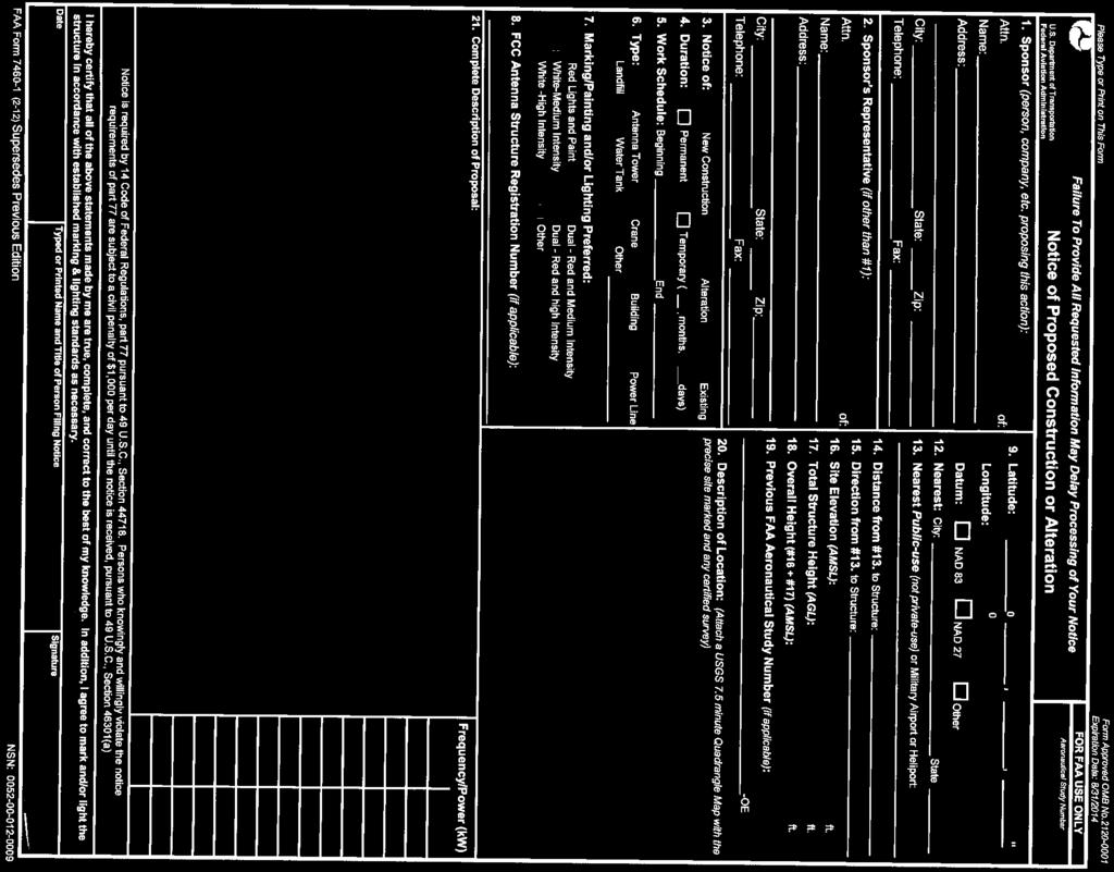
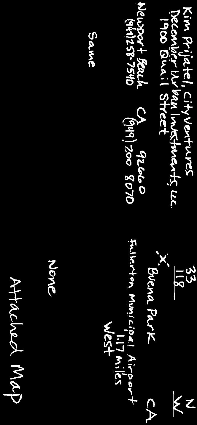
2 Mail Processing Center Federal Aviation Administration Southwest Regional Office Obstruction Evaluation Group 2601 Meacham Boulevard Fort Worth, TX Issued Date: 06/26/2014 Aeronautical Study No AWP-2473-OE Kim Prijatel City Ventures 1900 Quail Street Newport Beach, CA ** DETERMINATION OF NO HAZARD TO AIR NAVIGATION ** The Federal Aviation Administration has conducted an aeronautical study under the provisions of 49 U.S.C., Section and if applicable Title 14 of the Code of Federal Regulations, part 77, concerning: Structure: Building - Buena Park Nabisco Hotel/Residential Project Location: Buena Park, CA Latitude: N NAD 83 Longitude: W Heights: 70 feet site elevation (SE) 56 feet above ground level (AGL) 126 feet above mean sea level (AMSL) This aeronautical study revealed that the structure does not exceed obstruction standards and would not be a hazard to air navigation provided the following condition(s), if any, is(are) met: It is required that FAA Form , Notice of Actual Construction or Alteration, be e-filed any time the project is abandoned or: At least 10 days prior to start of construction (7460-2, Part 1) X Within 5 days after the construction reaches its greatest height (7460-2, Part 2) Based on this evaluation, marking and lighting are not necessary for aviation safety. However, if marking/ lighting are accomplished on a voluntary basis, we recommend it be installed and maintained in accordance with FAA Advisory circular 70/ K Change 2. This determination expires on 12/26/2015 unless: (a) (b) (c) the construction is started (not necessarily completed) and FAA Form , Notice of Actual Construction or Alteration, is received by this office. extended, revised, or terminated by the issuing office. the construction is subject to the licensing authority of the Federal Communications Commission (FCC) and an application for a construction permit has been filed, as required by the FCC, within 6 months of the date of this determination. In such case, the determination expires on the date prescribed by the FCC for completion of construction, or the date the FCC denies the application. Page 1 of 3
3 NOTE: REQUEST FOR EXTENSION OF THE EFFECTIVE PERIOD OF THIS DETERMINATION MUST BE E-FILED AT LEAST 15 DAYS PRIOR TO THE EXPIRATION DATE. AFTER RE-EVALUATION OF CURRENT OPERATIONS IN THE AREA OF THE STRUCTURE TO DETERMINE THAT NO SIGNIFICANT AERONAUTICAL CHANGES HAVE OCCURRED, YOUR DETERMINATION MAY BE ELIGIBLE FOR ONE EXTENSION OF THE EFFECTIVE PERIOD. This determination is based, in part, on the foregoing description which includes specific coordinates, heights, frequency(ies) and power. Any changes in coordinates, heights, and frequencies or use of greater power will void this determination. Any future construction or alteration, including increase to heights, power, or the addition of other transmitters, requires separate notice to the FAA. This determination does include temporary construction equipment such as cranes, derricks, etc., which may be used during actual construction of the structure. However, this equipment shall not exceed the overall heights as indicated above. Equipment which has a height greater than the studied structure requires separate notice to the FAA. This determination concerns the effect of this structure on the safe and efficient use of navigable airspace by aircraft and does not relieve the sponsor of compliance responsibilities relating to any law, ordinance, or regulation of any Federal, State, or local government body. Any failure or malfunction that lasts more than thirty (30) minutes and affects a top light or flashing obstruction light, regardless of its position, should be reported immediately to (877) so a Notice to Airmen (NOTAM) can be issued. As soon as the normal operation is restored, notify the same number. If we can be of further assistance, please contact our office at (310) On any future correspondence concerning this matter, please refer to Aeronautical Study Number 2014-AWP-2473-OE. Signature Control No: ( DNE ) LaDonna James Technician Attachment(s) Map(s) Page 2 of 3

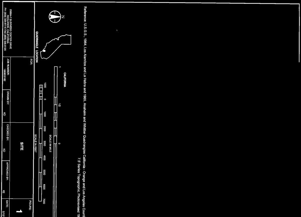
4 Verified Map for ASN 2014-AWP-2473-OE Page 3 of 3


5


6
7


8
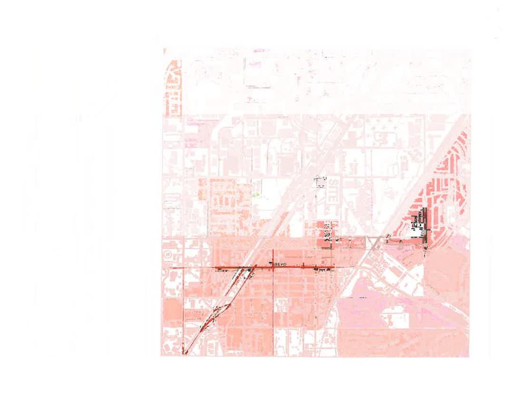
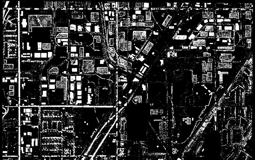
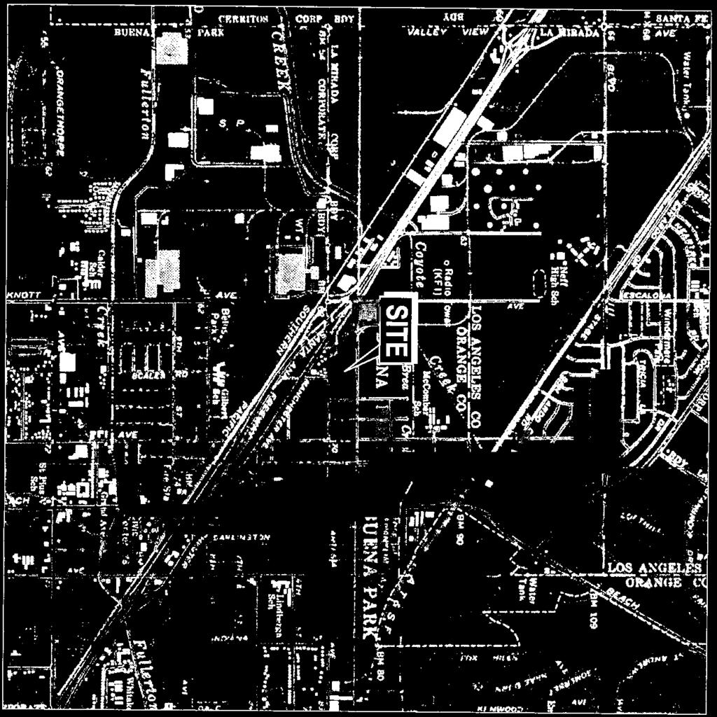
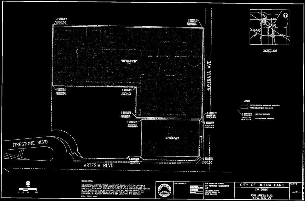
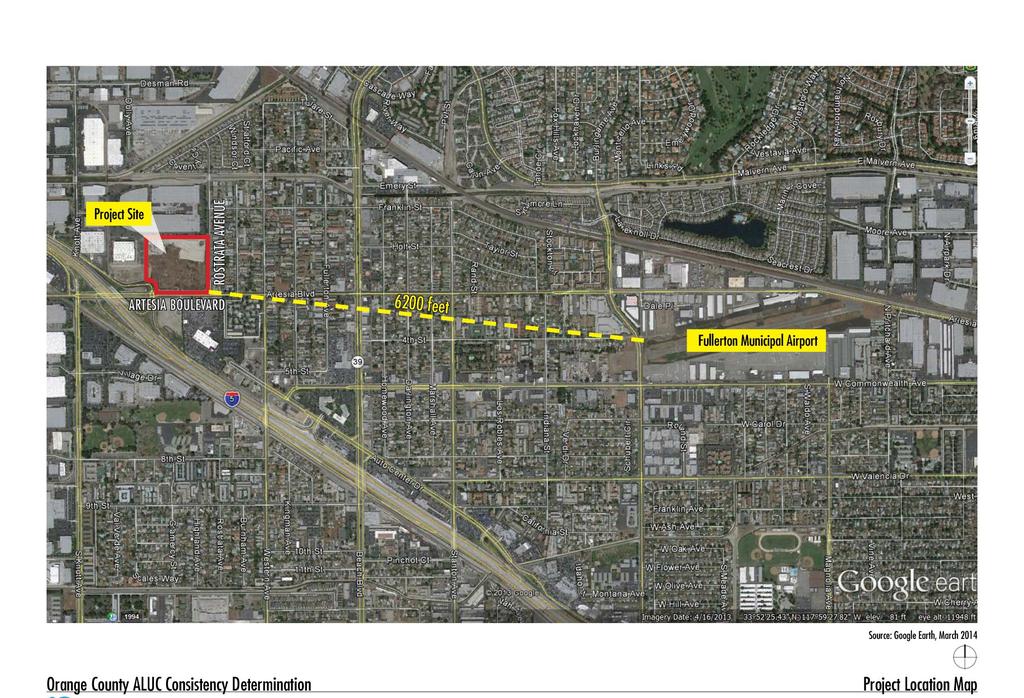
9 Orange County Airport Land Use Commission Request for Determination of Consistency With Fullerton AELUP City Ventures-Buena Park Mixed Use Project/Auto Center Specific Plan Amendment A. Project Description City Ventures, LLC is proposing a development plan consisting of an approximately 149 for-sale townhomes, an approximately 102-room hotel and a future new automobile sales auto dealership on approximately 14.7 acres of land in the City of Buena Park. The townhomes would occupy 8.5 acres in the northern part of the site, and these would all be constructed in three-story structures, with a maximum building height of 45 feet. Automobile parking would be provided in 298 attached garage spaces plus 130 open surface spaces, plus another 19 on-street spaces along Rostrata Avenue. A 21,750 square feet central recreation area for the residents is included in the townhome plan. The two-acre hotel site would include a four-story structure, containing approximately 66,775 square feet, with a maximum building height of 56 feet, along with 102 open, surface-level vehicle parking spaces surrounding the hotel building. The auto sales dealership plan is conceptual at this time, since no dealers have committed to develop on this site; however, a facility of approximately 40-45,000 square feet of building area is anticipated, with sales, administrative, display, outside storage, vehicle repair bays, surface parking, etc. to occupy the approximately 4-acre site. The building(s) could be single or two-story in height. Construction is tentatively scheduled to begin in late 2014, with full occupancy of all uses projected by The project site is located within Sub-District A4 of the Buena Park Auto Center Specific Plan (ACSP). The ACSP currently designates this site for automobile sales and leasing businesses, flood control and utility facilities, retail sales businesses, hotels, and a variety of other commercial land uses and associated accessory uses typically found in a retail area. Residential uses are currently not included in the range of permitted uses. The City s General Plan designates this site for Commercial land uses. The proposed project would require an amendment to the Buena Park General Plan to authorize the proposed residential land use. It would also require an amendment to the ACSP to allow the proposed residential land use, to specify the locations of the proposed hotel, residential and auto dealership sites. Other City approvals required for this project include a Tentative Subdivision Map to create individual development sites for the three land uses, to create a condominium subdivision with individual air space ownership rights for the proposed townhomes, and to assign appropriate identifications for any common areas. A Development Agreement is proposed to authorize the proposed development plan and to establish financial terms and levels of participation by the City and the Applicant. B. Project Location As shown on the attached Project Location exhibit, the project site is situated at the northwest corner of Artesia Boulevard and Rostrata Avenue, in the City of Buena Park. The I-5/Artesia Boulevard freeway interchange northbound ramps are immediately to the south, providing convenient access from the regional transportation network. The southeast corner of the Site is located 1.17 miles west of the Fullerton Municipal Airport. C. Existing and Proposed General Plan Designations The Buena Park General Plan currently designates the Site as Commercial. A General Plan Amendment is proposed to designate the proposed 8.5 acre townhome site as High Density Residential. 1
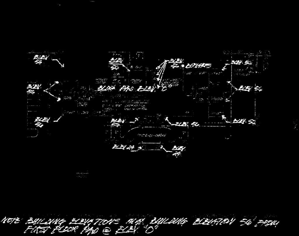
10 Orange County Airport Land Use Commission Request for Determination of Consistency With Fullerton AELUP City Ventures-Buena Park Mixed Use Project/Auto Center Specific Plan Amendment D. Land Uses on and Surrounding Project Site The Site is currently vacant. It was previously developed with a Nabisco Foods processing plant that operated between 1964 and the late-1990s. The Nabisco facilities were demolished and removed by The Site is in a fully urbanized area surrounded by a variety of light industrial uses to the north, south and west, a mixture of residential uses to the east, and the Carpenters Union Training Center is adjacent on the west. An aerial view of the existing land use pattern is provided in the Project Location exhibit. E. Approval Schedule Preparation of an environmental impact evaluation under CEQA is in process. Project approvals are tentatively scheduled to be considered by the Buena Park City Council in October F. Airport Noise Contours The Site lies several hundred feet beyond (west and north of) the 60 CNEL airport noise contour that is depicted on Exhibit A in Resolution No adopted by the Orange County ALUC, and contained within Appendix C of the Fullerton Municipal Airport Environs Land Use Plan (AELUP). ALUC staff have confirmed that the Site lies well beyond the 2002 or CNEL noise contours 1. This Site is, therefore, not significantly impacted by air traffic noise associated with the Fullerton Airport. G. Runway Protection and Accident Potential Zones The Site lies thousands of feet beyond the westernmost accidental potential zones identified for the Fullerton Airport, as depicted on the exhibit entitled Airport Impact Zones Fullerton Municipal Airport, found within Appendix D of the AELUP. This project would not, therefore, be exposed to significant hazards due to proximity to the airport accident potential zones. H. Height Restriction Zone The Site lies within the outer edge of the Height Restriction Zones depicted on the exhibit entitled FAR Part 77 Fullerton Municipal Airport Notification Area: 10,000 Foot Radius at 50:1 Slope, found within Appendix D of the AELUP. Buildings in the project site area are restricted to a maximum height of approximately 219 to 235 feet above mean sea level 2. Average ground elevation at the project Site is 70 feet above sea level. The proposed townhomes would have a maximum building height of 45 feet and the proposed three-story hotel would have a maximum building height of 56 feet. The future auto dealer buildings would be no higher than two-stories/35 feet high. The proposed buildings would reach a maximum height of approximately 126 feet above sea level, which is 93 feet lower than the lowest permitted elevation in the 50:1 Slope Zone. This project would not, therefore, conflict with the height restrictions established for this area. 1 See correspondence from Lea Choum, ALUC, March 25, Maximum building height elevations provided by Orange County Airport Land Use Commission staff on March 25, 2014 (see attached correspondence between Lea Choum of ALUC and Randy Nichols of p3 services). 2
11 Orange County Airport Land Use Commission Request for Determination of Consistency With Fullerton AELUP City Ventures-Buena Park Mixed Use Project/Auto Center Specific Plan Amendment Further, the Site lies hundreds of feet beyond the outermost ring of the FAR Part 77 Imaginary Surfaces established for the Fullerton Airport, as depicted on the exhibit entitled FAR Part 77 Fullerton Municipal Airport Obstruction Imaginary Surfaces, found in Appendix D of the AELUP. This restricted space is also referred to as the 20:1 Conical Surface Area. Maximum building heights on the Site defined by ALUC for this 20:1 Conical Surface area range from feet above sea level. 3 The proposed structures would reach a maximum height of 126 feet AMSL; therefore, they would not project into this restricted air space. I. Relevant CEQA Documentation An Initial Study is underway to examine the environmental impacts of the proposed project, pursuant to CEQA. The Initial Study will incorporate the above findings regarding less than significant impacts involving airport traffic noise and safety risks associated with runway hazards and no impact involving obstructions of air traffic space. 3 See attached correspondence between ALUC staff and p3 services. 3

12
13 3/27/2014 p3 services Mail - Building Height Limits in Buena Park portion of Fullerton Airport Height Restriction Zone? Randy Nichols <randy.nichols@p3services.net> Building Height Limits in Buena Park portion of Fullerton Airport Height Restriction Zone? 11 messages Randy Nichols <randy.nichols@p3services.net> To: "krigoni@ocair.com" <krigoni@ocair.com> Fri, Mar 21, 2014 at 2:28 PM Hello. I am compiling materials for the City of Buena Park to submit for an ALUC consistency determination, for a new development proposal in Buena Park, at the NW corner of Artesia Blvd./Rostrata Avenue. This site falls in the outer edge of the Fullerton Airport's FAA Height Restriction Zone, but I am not finding any info within the AELUP that defines the actual building height limits in this area, in terms of # of feet above ground level. We want to define the limit within our ALUC submittal so we can easily demonstrate that the proposed three-story structures are well below the height restriction limit. Can you send me any materials that define the applicable height limits defined for the Buena Park area? -- Randy A. Nichols, LEED GA Principal Consultant, p3 services Moulton Parkway, Ste. O #192 Laguna Hills, CA randy.nichols@p3services.net Randy Nichols <randy.nichols@p3services.net> To: "Ochoa, Elizabeth" <EOchoa@ocair.com> Fri, Mar 21, 2014 at 3:40 PM Hello. Since Ms. Rigoni is out today, I am forwarding this request to you as well. Thanks. [Quoted text hidden] Choum, Lea <LChoum@ocair.com> To: "randy.nichols@p3services.net" <randy.nichols@p3services.net> Mon, Mar 24, 2014 at 1:02 PM Hello Mr. Nichols, 1/9
14 3/27/2014 p3 services Mail - Building Height Limits in Buena Park portion of Fullerton Airport Height Restriction Zone? We would be happy to review the proposed project and let you know the height restrictions for FMA if you could provide us with the following: Site Address Latitute/Longitute coordinates for the proposed project site Proposed height of project Ground Elevation Brief description of proposed project Thank you, Lea Lea Choum, Land Use Manager John Wayne Airport, Orange County Airway Avenue Costa Mesa, CA [Quoted text hidden] 2/9

15 3/27/2014 p3 services Mail - Building Height Limits in Buena Park portion of Fullerton Airport Height Restriction Zone? image002.jpg 15K Randy Nichols <randy.nichols@p3services.net> To: "Choum, Lea" <LChoum@ocair.com> Mon, Mar 24, 2014 at 3:01 PM There is no site address, as it is vacant. It is a 14.5 acre area, situated at the northwest corner of Artesia Blvd. and Rostrata Ave., in Buena Park. Latitude and longitude are as follows: 33 degrees 52 feet 28.6 inches North 118 degrees 00 feet 27.53" West Hotel would be 4-stories tall, with a maximum height of 56 feet. Townhomes would be three stories tall, with a maximum height of less than 50 feet. Future auto dealer(s) buildings would be up to two-stories/35 feet tall. Ground elevation is approximately 70 feet above sea level. Project is a development plan, including approximately 163 residential townhomes on 8.5 acres, an approximately 100-room hotel on two acres, and one-two auto dealers on four acres. [Quoted text hidden] Choum, Lea <LChoum@ocair.com> To: Randy Nichols <randy.nichols@p3services.net> Tue, Mar 25, 2014 at 8:22 AM Thank you. I will let you know when our CAD expert finishes his review. 3/9
16 3/27/2014 p3 services Mail - Building Height Limits in Buena Park portion of Fullerton Airport Height Restriction Zone? Lea From: Randy Nichols [mailto:randy.nichols@p3services.net] Sent: Monday, March 24, :02 PM To: Choum, Lea Subject: Re: FW: Building Height Limits in Buena Park portion of Fullerton Airport Height Restriction Zone? [Quoted text hidden] Randy Nichols <randy.nichols@p3services.net> To: "Choum, Lea" <LChoum@ocair.com> Tue, Mar 25, 2014 at 9:10 AM Great-thanks! Do you think this will be in a day or two? We are close to finishing our ALUC review materials and this info is an important part of that. [Quoted text hidden] Choum, Lea <LChoum@ocair.com> To: Randy Nichols <randy.nichols@p3services.net> Tue, Mar 25, 2014 at 9:45 AM I will check with our CAD person and see what his schedule is like. Lea From: Randy Nichols [mailto:randy.nichols@p3services.net] Sent: Tuesday, March 25, :11 AM [Quoted text hidden] [Quoted text hidden] Choum, Lea <LChoum@ocair.com> To: Randy Nichols <randy.nichols@p3services.net> Tue, Mar 25, 2014 at 4:16 PM Randy, 4/9
17 3/27/2014 p3 services Mail - Building Height Limits in Buena Park portion of Fullerton Airport Height Restriction Zone? Here s the information you requested for the property located at the northwest corner of Artesia Blvd. and Rostrata Ave., in Buena Park. Per the Airport Environs Land Use Plan for Fullerton Municipal Airport (FMA): For Notification Area at 50:1 Slope The addresses are situated right under the 50:1-Slope Notification Area with elevation limitation varies from EL to EL AMSL. For Fullerton Municipal Airport Part 77 Airspace Plan: This property is within the Conical Surface (Slope 20:1) with elevation limitation varies from EL. 300 to EL. 340 AMSL For Fullerton Municipal Airport Impact Zone: The address is neither situated within 2002 nor CNEL Noise Contour. It appears that your proposed project heights would not penetrate the surfaces for FMA. Hotel AMSL = 126 AMSL Townhomes AMSL = 120 AMSL Auto dealers AMSL 105 AMSL Thank you, Lea 5/9
** DETERMINATION OF NO HAZARD TO AIR NAVIGATION **
 Mail Processing Center Federal Aviation Administration Southwest Regional Office Obstruction Evaluation Group 10101 Hillwood Parkway Fort Worth, TX 76177 Issued Date: 07/29/2016 Aeronautical Study No.
** DETERMINATION OF NO HAZARD TO AIR NAVIGATION **
 Mail Processing Center Federal Aviation Administration Southwest Regional Office Obstruction Evaluation Group 2601 Meacham Boulevard Fort Worth, TX 76137 Issued Date: 08/15/2012 Aeronautical Study No.
** DETERMINATION OF NO HAZARD TO AIR NAVIGATION **
 Mail Processing Center Federal Aviation Administration Southwest Regional Office Obstruction Evaluation Group 2601 Meacham Boulevard Fort Worth, TX 76137 Issued Date: 01/04/2012 Aeronautical Study No.
** DETERMINATION OF NO HAZARD TO AIR NAVIGATION **
 Mail Processing Center Federal Aviation Administration Southwest Regional Office Obstruction Evaluation Group 2601 Meacham Boulevard Fort Worth, TX 76137 Issued Date: 05/16/2011 Aeronautical Study No.
** DETERMINATION OF NO HAZARD TO AIR NAVIGATION **
 Mail Processing Center Federal Aviation Administration Southwest Regional Office Obstruction Evaluation Group 2601 Meacham Boulevard Fort Worth, TX 76137 Issued Date: 07/03/2013 Aeronautical Study No.
** DETERMINATION OF NO HAZARD TO AIR NAVIGATION **
 Federal Aviation Administration Air Traffic Airspace Branch, ASW-520 2601 Meacham Blvd. Fort Worth, TX 76137-0520 Aeronautical Study No. 2010-WTE-13969-OE Issued Date: 09/30/2010 Morgan Johnston University
5 Acre Hard Corner Las Vegas Blvd Frontage
 Glenn Dulaine, CCIM 331 N Buffalo Drive #110 Las Vegas, NV 89145 (702) 596-9890 Direct (702) 974-0199 Fax 5 Acre Hard Corner Las Vegas Blvd Frontage Highlights: Location: Las Vegas Blvd. Frontage H-1 &
STAFF REPORT. Airport Land Use Plan Consistency Review: Old Town Village Mixed Use Project City of Goleta. MEETING DATE: June 18, 2015 AGENDA ITEM: 5M
 STAFF REPORT SUBJECT: Airport Land Use Plan Consistency Review: Old Town Village Mixed Use Project City of Goleta MEETING DATE: AGENDA ITEM: 5M STAFF CONTACT: Peter Imhof, Andrew Orfila RECOMMENDATION:
STAFF REPORT. Airport Land Use Consistency Determination Betteravia Plaza. MEETING DATE: January 21, 2016 AGENDA ITEM: 8D
 STAFF REPORT SUBJECT: Airport Land Use Consistency Determination Betteravia Plaza MEETING DATE: AGENDA ITEM: 8D STAFF CONTACT: Andrew Orfila RECOMMENDATION: Adopt findings for the Betteravia Plaza project
The following criteria shall be applied within the boundaries of the AO District:
 Sec. 419 (a) Purpose AIRPORT OVERLAY DISTRICT (AO) The purpose of the Airport Overlay District is to regulate and restrict the height of structures, objects, or natural growth, regulate the locations of
Appendix K Airport Land Use Commission Development Review
 Appendix K Airport Land Use Commission Development Review AIRPORT LAND USE COMMISSION RIVERSIDE COUNTY CHAIR Simon Housman Rancho Mirage VICE CHAIRMAN Rod Ballance COMMISSIONERS Arthur Butler John Lyon
Boise Municipal Code. Chapter DEFINITIONS
 Chapter 12-03 DEFINITIONS Sections: 12-03-01 ADMINISTRATOR 12-03-02 AIRPORT DESIGNATIONS 12-03-03 AIRPORT HAZARD 12-03-04 AIRPORT HEIGHT LIMITATIONS 12-03-05 AIRPORT REFERENCE POINT 12-03-06 AIRPORT INSTRUMENT
Notice of Extended Comment Period for an Intent to Adopt a Negative Declaration
 County of Santa Clara Department of Planning and Development Planning Office County Government Center, East Wing, 7 th Floor 70 West Hedding Street San Jose, California 95110-1705 (408) 299-5770 FAX (408)
AVIATION PLANNING AND DEVELOPMENT Oakland International Airport 530 Water Street Oakland, CA 94607
 AVIATION PLANNING AND DEVELOPMENT Oakland International Airport 530 Water Street When Do I Need to File an FAA Form 7460-1? Objects Affecting Navigable Airspace (14CFR77) June 2013 Background The Federal
SITE ELEVATION AMSL...Ground Elevation in feet AMSL STRUCTURE HEIGHT...Height Above Ground Level OVERALL HEIGHT AMSL...Total Overall Height AMSL
 ******************************************** * Federal Airways & Airspace * * Summary Report * ******************************************** File: User Assigned File Name Latitude: NAD83 Coordinate Longitude:
RULES OF TENNESSEE DEPARTMENT OF TRANSPORTATION AERONAUTICS DIVISION CHAPTER LICENSING AND REGISTRATION OF AIRPORTS TABLE OF CONTENTS
 RULES OF TENNESSEE DEPARTMENT OF TRANSPORTATION AERONAUTICS DIVISION CHAPTER 1680-1-2 LICENSING AND REGISTRATION OF AIRPORTS TABLE OF CONTENTS 1680-1-2-.01 Purpose 1680-1-2-.06 Repealed 1680-1-2-.02 Definitions
APPENDIX K LAND USE. Charles M. Schulz - Sonoma County Airport Draft Environmental Impact Report July 2011 K-1
 APPENDIX K LAND USE Charles M. Schulz - Sonoma County Airport Draft Environmental Impact Report July 2011 K-1 Appendix K Land Use THIS PAGE INTENTIONALLY LEFT BLANK Charles M. Schulz - Sonoma County Airport
Appendix C AIRPORT LAYOUT PLANS
 Appendix C AIRPORT LAYOUT PLANS Appendix C AIRPORT LAYOUT PLANS Airport Master Plan Santa Barbara Airport As part of this Airport Master Plan, the Federal Aviation Administration (FAA) requires the development
ORDINANCE NO. _2013-
 ORDINANCE NO. _2013- AN ORDINANCE OF THE TOWNSHIP OF CONEWAGO, DAUPHIN COUNTY, PENNSYLVANIA, PROVIDING FOR AIRPORT ZONING REGULATIONS WITHIN THE AIRPORT ZONING OVERLAY DISTRICT CREATED BY THIS ORDINANCE
NOTICE TO PROPOSED CITY PERMITS: ZONING HEIGHT RESTRICTIONS/APPROVAL PROCESS
 NOTICE TO PROPOSED CITY PERMITS: ZONING HEIGHT RESTRICTIONS/APPROVAL PROCESS Dear Prospective Permittee: The City of St Petersburg (City) issues permits for construction projects based on local and state
AIRPORT LAND USE COMPATILIBILTY AIRPORT LAND USE COMPATIBILIITY
 CHAPTER 7 AIRPORT LAND USE COMPATILIBILTY CHAPTER 7 AIRPORT LAND USE COMPATIBILIITY 7.0 INTRODUCTION On airport aviation related development is typically compatible with aircraft operations. On airport
APPENDIX D FEDERAL AVIATION REGULATIONS, PART 77
 APPENDIX D FEDERAL AVIATION REGULATIONS, PART 77 Subparts A through C PART 77 - OBJECTS AFFECTING NAVIGABLE AIRSPACE Subpart A General 77.1 Scope. 77.2 Definition of terms. 77.3 Standards. 77.5 Kinds of
SUMMARY: This action establishes Class E airspace at Parkston, SD. Controlled airspace
 This document is scheduled to be published in the Federal Register on 07/12/2013 and available online at http://federalregister.gov/a/2013-16436, and on FDsys.gov [4910-13] DEPARTMENT OF TRANSPORTATION
AIRSPACE PROTECTION. Guidance and considerations for development in the vicinity of Ohio s airports and heliports
 AIRSPACE PROTECTION Guidance and considerations for development in the vicinity of Ohio s airports and heliports UPDATED SPRING 2018 AIRSPACE PROTECTION When construction is proposed near public use airports
SUPERSEDED [ U] DEPARTMENT OF TRANSPORTATION. Federal Aviation Administration. 14 CFR Part 39 [66 FR /5/2001]
![SUPERSEDED [ U] DEPARTMENT OF TRANSPORTATION. Federal Aviation Administration. 14 CFR Part 39 [66 FR /5/2001]](/thumbs/89/99040723.jpg "SUPERSEDED [ U] DEPARTMENT OF TRANSPORTATION. Federal Aviation Administration. 14 CFR Part 39 [66 FR /5/2001]") [4910-13-U] DEPARTMENT OF TRANSPORTATION Federal Aviation Administration 14 CFR Part 39 [66 FR 13227 3/5/2001] [Docket No. 2000-NM-416-AD; Amendment 39-12128; AD 2001-04-09] RIN 2120-AA64 Airworthiness
[4910-13-U] DEPARTMENT OF TRANSPORTATION Federal Aviation Administration 14 CFR Part 39 [66 FR 13227 3/5/2001] [Docket No. 2000-NM-416-AD; Amendment 39-12128; AD 2001-04-09] RIN 2120-AA64 Airworthiness
ARTICLE 34 AIRPORT HEIGHT COMBINING ZONE (AH) (Amended by Ordinance #295 Effective June 26, 2009)
 (Amended by Ordinance #295 Effective June 26, 2009)") ARTICLE 34 AIRPORT HEIGHT COMBINING ZONE (AH) (Amended by Ordinance #295 Effective June 26, 2009) Section 34.10 - Purpose and Intent The purpose of the Airport Height Combining Zone (AH) is to protect
ARTICLE 34 AIRPORT HEIGHT COMBINING ZONE (AH) (Amended by Ordinance #295 Effective June 26, 2009) Section 34.10 - Purpose and Intent The purpose of the Airport Height Combining Zone (AH) is to protect
Airport Land Use Commission AIRPORT ENVIRONS. LAND USE PLAN for JOHN WAYNE AIRPORT
 Airport Land Use Commission AIRPORT ENVIRONS LAND USE PLAN for JOHN WAYNE AIRPORT Amended: April 17, 2008 AIRPORT ENVIRONS LAND USE PLAN April 17, 2008 Text of Plan Adopted April 17, 1975 Marine Corps
STAFF REPORT. Airport Land Use Plan Consistency Review: Santa Barbara Airport Master Plan. MEETING DATE: November 19, 2015 AGENDA ITEM: 7D
 STAFF REPORT SUBJECT: Airport Land Use Plan Consistency Review: Santa Barbara Airport Master Plan MEETING DATE: AGENDA ITEM: 7D STAFF CONTACT: Peter Imhof, Andrew Orfila RECOMMENDATION: Adopt findings
Airport Land Use Commission. AIRPORT ENVIRONS LAND USE PLAN for FULLERTON MUNICIPAL AIRPORT
 Airport Land Use Commission AIRPORT ENVIRONS LAND USE PLAN for FULLERTON MUNICIPAL AIRPORT Amended: November 18, 2004 AIRPORT ENVIRONS LAND USE PLAN November 18, 2004 Text of Plan Adopted April 17, 1975
DRAFT GENERAL IMPLEMENTATION PLAN AND SPECIFIC IMPLEMENTATION PLAN MIDDLETON MUNICIPAL AIRPORT MOREY FIELD. Revised 12/12/03
 DRAFT GENERAL IMPLEMENTATION PLAN AND SPECIFIC IMPLEMENTATION PLAN MIDDLETON MUNICIPAL AIRPORT MOREY FIELD Revised 12/12/03 As recommended for approval by the Plan Commission General Project Description
For Airport Environmental Services. Date Released: August 27, 2018 Deadline for Submission: 5:00pm, September 17, 2018
 COUNTY OF INYO REQUEST FOR QUALIFICATIONS For Airport Environmental Services Date Released: August 27, 2018 Deadline for Submission: 5:00pm, September 17, 2018 County of Inyo Public Works Department P.O.
INVENERGY SERVICES LLC
 4/8/214 Table of Contents 1. Purpose(s):... - 2-2. Applicability:... - 2-3. References:... - 2-4. Overview:... - 2-5. Policy... - 2-6. Responsibilities:... - 3-6.1. Invenergy Services O&M personnel...-
Part 77 CAA Consolidation 1 April 2014 Objects and Activities Affecting Navigable Airspace
 Part 77 CAA Consolidation 1 April 2014 Objects and Activities Affecting Navigable Airspace Published by the Civil Aviation Authority of New Zealand DESCRIPTION Part 77 prescribes rules for persons proposing
Part 77 and Construction
 Part 77 and Construction Presented to: By: Date: Advanced ASOS Steven Oetzell October 18, 2016 14 CFR Part 77, Objects Affecting Navigable Airspace Reporting objects to the FAA 14 CFR Part 139.331 states
Chapter Six ALP Drawings. Tacoma Narrows Airport. Master Plan Update
 Chapter Six ALP Drawings Master Plan Update The master planning process for the (Airport) has evolved through efforts in the previous chapters to analyze future aviation demand, establish airside and landside
Flying Cloud Airport (FCM) Zoning Process: Informing a Mn/DOT Path Forward
 Zoning Process: Informing a Mn/DOT Path Forward") : Informing a Mn/DOT Path Forward A Review of the Flying Cloud Airport (FCM) Joint Airport Zoning Board (JAZB) Process and the Draft Airport Zoning Ordinance B A RPZ RPZ A B C Zone Chad E. Leqve Director
: Informing a Mn/DOT Path Forward A Review of the Flying Cloud Airport (FCM) Joint Airport Zoning Board (JAZB) Process and the Draft Airport Zoning Ordinance B A RPZ RPZ A B C Zone Chad E. Leqve Director
[Docket No. FAA ; Airspace Docket No. 13-ASW-2] Proposed Amendment of Class E Airspace; Fort Polk, LA
![[Docket No. FAA ; Airspace Docket No. 13-ASW-2] Proposed Amendment of Class E Airspace; Fort Polk, LA](/thumbs/95/125852980.jpg "[Docket No. FAA ; Airspace Docket No. 13-ASW-2] Proposed Amendment of Class E Airspace; Fort Polk, LA") This document is scheduled to be published in the Federal Register on 04/30/2013 and available online at http://federalregister.gov/a/2013-10169, and on FDsys.gov [4901-13] DEPARTMENT OF TRANSPORTATION
This document is scheduled to be published in the Federal Register on 04/30/2013 and available online at http://federalregister.gov/a/2013-10169, and on FDsys.gov [4901-13] DEPARTMENT OF TRANSPORTATION
FAA FORM UAS COA Attachment FAA
 Page 1 of 6 DEPARTMENT OF TRANSPORTATION FEDERAL AVIATION ADMINISTRATION CERTIFICATE OF WAIVER OR AUTHORIZATION ISSUED TO Xcam Aerials, Inc. 10197 SE 144th Place Summerfield, FL 34491 This certificate
VARIOUS RESTRICTED CATEGORY HELICOPTERS
 Page 1 2012-14-11 VARIOUS RESTRICTED CATEGORY HELICOPTERS Amendment 39-17125 Docket No. FAA-2012-0739; Directorate Identifier 2012-SW-044-AD. PREAMBLE (a) Applicability This AD applies to Arrow Falcon
CHAPTER 6 NOISE EXPOSURE
 CHAPTER 6 NOISE EXPOSURE FAA requires that the NEM submitted for review represent the aircraft noise exposure for the year of submittal (in this case 2008) and for a future year (2013 for OSUA). However,
Proposed Establishment of and Modification to Restricted Areas; Fort Sill, OK
 This document is scheduled to be published in the Federal Register on 10/19/2015 and available online at http://federalregister.gov/a/2015-26499, and on FDsys.gov 4910-13 DEPARTMENT OF TRANSPORTATION Federal
Background Data: Blue Canyon Airport and Environs
 5 Background Data: and Environs INTRODUCTION serves as an important emergency landing field amid mountainous terrain. The airport has existed on the site since the 1930s or 40s. The facility was operated
Ordinance No Amendments to Airport Ordinance 87-8
 SECTION 1. SUMMARY. This Ordinance adds various provisions to uncodified County Ordinance 87-8 ("the Airport Regulations"), amends and renumbers various provisions of the Airport Regulations, and adds
Hearings will be held in the Shirley Huffman Auditorium in the Charles D. Cameron Public Services Building, 155 North First Avenue, Hillsboro, Oregon.
 Hearings will be held in the Shirley Huffman Auditorium in the Charles D. Cameron Public Services Building, 155 North First Avenue, Hillsboro, Oregon. On September 24, 2013, the Board of County Commissioners
Airport Land Use Compatibility Plan (ALUCP) Update. Public Information Meeting #4 June 8 & 9, 2016
 Update. Public Information Meeting #4 June 8 & 9, 2016") Airport Land Use Compatibility Plan (ALUCP) Update Public Information Meeting #4 June 8 & 9, 2016 Agenda 1. Study Process 2. Noise Complaint Patterns 3. Proposed Overflight Areas (AOA) 4. Proposed Land
Airport Land Use Compatibility Plan (ALUCP) Update Public Information Meeting #4 June 8 & 9, 2016 Agenda 1. Study Process 2. Noise Complaint Patterns 3. Proposed Overflight Areas (AOA) 4. Proposed Land
Official Journal of the European Union L 186/27
 7.7.2006 Official Journal of the European Union L 186/27 COMMISSION REGULATION (EC) No 1032/2006 of 6 July 2006 laying down requirements for automatic systems for the exchange of flight data for the purpose
National Transportation Safety Board Recommendation and FAA Air Traffic Orders
 Page 1 of 8 MEMORANDUM TO: Planning, Development and Environment Committee FROM: Chad E. Leqve, Director Environment (725.6326) SUBJECT: NOISE OVERSIGHT COMMITTEE (NOC) CONVERGING RUNWAY OPERATION (CRO)
Initiated By: AFS-400
 U.S. Department of Transportation Federal Aviation Administration Advisory Circular Subject: Development and Submission of Special Date: 04/14/2015 AC No: 90-112A Instrument Procedures to the FAA Initiated
[Docket No SW-25-AD; Amendment ; AD R1]
![[Docket No SW-25-AD; Amendment ; AD R1]](/thumbs/94/120860064.jpg "[Docket No SW-25-AD; Amendment ; AD R1]") [Federal Register: July 6, 2004 (Volume 69, Number 128)] [Rules and Regulations] [Page 40539-40541] From the Federal Register Online via GPO Access [wais.access.gpo.gov] [DOCID:fr06jy04-4] DEPARTMENT OF
[Federal Register: July 6, 2004 (Volume 69, Number 128)] [Rules and Regulations] [Page 40539-40541] From the Federal Register Online via GPO Access [wais.access.gpo.gov] [DOCID:fr06jy04-4] DEPARTMENT OF
BELL HELICOPTER TEXTRON (BELL)
") Page 1 2013-03-16 BELL HELICOPTER TEXTRON (BELL) Amendment 39-17339 Docket No. FAA-2013-0098; Directorate Identifier 2011-SW-39-AD PREAMBLE (a) Applicability This AD applies to Model 204B, 205A, 205A-1,
Page 1 2013-03-16 BELL HELICOPTER TEXTRON (BELL) Amendment 39-17339 Docket No. FAA-2013-0098; Directorate Identifier 2011-SW-39-AD PREAMBLE (a) Applicability This AD applies to Model 204B, 205A, 205A-1,
EAGLE RIVER UNION AIRPORT HANGAR CONSTRUCTION GUIDELINES Approved 1/29/2008
 EAGLE RIVER UNION AIRPORT HANGAR CONSTRUCTION GUIDELINES Approved 1/29/2008 SECTION 1 - PURPOSE AND SCOPE 1.1 Purpose This document is designed to serve as a guide for private and commercial hangar construction
[Docket No. FAA ; Product Identifier 2018-NM-039-AD] AGENCY: Federal Aviation Administration (FAA), DOT.
![[Docket No. FAA ; Product Identifier 2018-NM-039-AD] AGENCY: Federal Aviation Administration (FAA), DOT.](/thumbs/87/96493812.jpg "[Docket No. FAA ; Product Identifier 2018-NM-039-AD] AGENCY: Federal Aviation Administration (FAA), DOT.") This document is scheduled to be published in the Federal Register on 04/30/2018 and available online at https://federalregister.gov/d/2018-08757, and on FDsys.gov [4910-13-P] DEPARTMENT OF TRANSPORTATION
This document is scheduled to be published in the Federal Register on 04/30/2018 and available online at https://federalregister.gov/d/2018-08757, and on FDsys.gov [4910-13-P] DEPARTMENT OF TRANSPORTATION
Tinker Air Force Base, Oklahoma
 Table 5.4 Generalized Zoning within the Tinker AFB Clear Zones and Accident Potential Zones (Off-Installation) Category Acreage Residential 1,486 Commercial 191 Industrial 128 Public/Quasi-public 0 Recreational/Open/Agricultural/Low
Proposed Amendment of Class E Airspace for the following South Dakota Towns: Belle Fourche, SD; Madison, SD; Mobrigde, SD; and Vermillion, SD
 This document is scheduled to be published in the Federal Register on 02/17/2016 and available online at http://federalregister.gov/a/2016-03066, and on FDsys.gov [04910-13] DEPARTMENT OF TRANSPORTATION
Advisory Circular. Canada and United States Bilateral Aviation Safety Agreement Maintenance Implementation Procedures
 Advisory Circular Subject: Issuing Office: Canada and United States Bilateral Aviation Safety Agreement Maintenance Implementation Procedures Aircraft Maintenance and Manufacturing Activity Area: Rulemaking
Airport Zoning Regulations
 Airport Zoning Regulations Tampa International Airport Tampa Executive Airport Peter O. Knight Airport Plant City Airport Hillsborough County Aviation Authority June 1, 2017 TABLE OF CONTENTS Page Section
AIRPORT COMPLIANCE th Texas Aviation Conference. 3/29/2018 Date. Footer Text
 AIRPORT COMPLIANCE 2018 36 th Texas Aviation Conference 3/29/2018 AWOS FCC LICENSE RENEWAL Needs renewal every 10 years (renew 90 days before expiration). Needs update if there is name change, coordinate
DEVILS LAKE MUNICIPAL AIRPORT AERIAL APPLICATOR OPERATING PERMIT
 1 DEVILS LAKE MUNICIPAL AIRPORT AERIAL APPLICATOR OPERATING PERMIT PURPOSE In order for all aerial applicators who use the Devils Lake Municipal Airport to operate under the same rules and procedures,
Article 11 Airport District
 Cities County A Article 11 Article 11 Section 11.01 Intent (a) A. The A is established to provide for uses, activities, facilities, and structures necessary for the safe and efficient operation of aircraft
Consideration will be given to other methods of compliance which may be presented to the Authority.
 Advisory Circular AC 139-10 Revision 1 Control of Obstacles 27 April 2007 General Civil Aviation Authority advisory circulars (AC) contain information about standards, practices and procedures that the
AIRWORTHINESS CERTIFICATION OF AIRCRAFT AND RELATED PRODUCTS. 1. PURPOSE. This change is issued to incorporate revised operating limitations.
 8130.2D 2/15/00 AIRWORTHINESS CERTIFICATION OF AIRCRAFT AND RELATED PRODUCTS 1. PURPOSE. This change is issued to incorporate revised operating limitations. 2. DISTRIBUTION. This change is distributed
Comparison Between Old and New ALUC Plans
 A P P E N I X H Comparison Between Old and New ALUC Plans OVERVIEW This Placer County Airport Land Use Compatibility Plan (ALUCP) sets forth land use compatibility criteria for the environs of Auburn Municipal,
II.J. 14 CFR and Publications
 References: 14 CFR Parts 1, 61, 91; NTSB Part 830; AC 00-2; FAA-H-8083-25; POH/AFM; AIM Objectives Key Elements Elements Schedule Equipment IP s Actions SP s Actions Completion Standards The student should
OVERSEAS TERRITORIES AVIATION REQUIREMENTS (OTARs)
") OVERSEAS TERRITORIES AVIATION REQUIREMENTS (OTARs) Part 171 AERONAUTICAL TELECOMMUNICATION SERVICES Published by Air Safety Support International Ltd Air Safety Support International Limited 2005 First
OVERSEAS TERRITORIES AVIATION REQUIREMENTS (OTARs) Part 171 AERONAUTICAL TELECOMMUNICATION SERVICES Published by Air Safety Support International Ltd Air Safety Support International Limited 2005 First
Bell Helicopter Textron
 Page 1 2012-22-11 Bell Helicopter Textron Amendment 39-17247 Docket No. FAA-2012-0530; Directorate Identifier 2011-SW-075-AD PREAMBLE (a) Applicability This AD applies to Model 412 and 412EP helicopters,
TITLE 16. DEPARTMENT OF TRANSPORTATION CHAPTER 62. AIR SAFETY AND ZONING
 NOTE: This is a courtesy copy of this rule. The official version can be found in the New Jersey Administrative Code. Should there be any discrepancies between this text and the official version, the official
[Docket No. FAA ; Product Identifier 2017-SW-004-AD] Airworthiness Directives; Airbus Helicopters Deutschland GmbH (Type Certificate
![[Docket No. FAA ; Product Identifier 2017-SW-004-AD] Airworthiness Directives; Airbus Helicopters Deutschland GmbH (Type Certificate](/thumbs/74/70260856.jpg "[Docket No. FAA ; Product Identifier 2017-SW-004-AD] Airworthiness Directives; Airbus Helicopters Deutschland GmbH (Type Certificate") This document is scheduled to be published in the Federal Register on 11/03/2017 and available online at https://federalregister.gov/d/2017-23201, and on FDsys.gov [4910-13-P] DEPARTMENT OF TRANSPORTATION
This document is scheduled to be published in the Federal Register on 11/03/2017 and available online at https://federalregister.gov/d/2017-23201, and on FDsys.gov [4910-13-P] DEPARTMENT OF TRANSPORTATION
-NOTE: NOT TO BE USED FOR NAVIGATION PURPOSES-
 APPENDIX 1-B INSTRUMENT APPROACH PROCEDURES March 2010 SKYHAVEN AIRPORT -NOTE: NOT TO BE USED FOR NAVIGATION PURPOSES- -NOTE: NOT TO BE USED FOR NAVIGATION PURPOSES- -NOTE: NOT TO BE USED FOR NAVIGATION
SUBCHAPTER E AIRSPACE
 PART 71 DESIGNATION OF CLASS A, B, C, D, AND E AIRSPACE AREAS; AIR TRAFFIC SERVICE ROUTES; AND REPORTING POINTS Sec. SPECIAL FEDERAL AVIATION REGULATION NO. 97 [NOTE] 71.1 Applicability. 71.3 [Reserved]
SECTION 2 - GENERAL REGULATIONS
 SECTION 2 - GENERAL REGULATIONS 2.01 COMPLIANCE WITH RULES AND REGULATIONS a. Any permission granted by the City, directly or indirectly, expressly, or by implication or otherwise, to any Person to enter
Airport Obstruction Standards
 Airport Obstruction Standards Dr. Antonio Trani Department of Civil and Environmental Engineering Virginia Tech Outline of this Presentation Obstructions to navigation around airports Discussion of Federal
Albuquerque Aerostat Ascension Association
 Attachment C Albuquerque Aerostat Ascension Association Balloon Flight Operations Manual AAAA Flying Events AAAA Balloon Flight Operations Manual Table of Contents This manual has been prepared as part
SUPERSEDED. [Docket No. FAA ; Directorate Identifier 2011-SW-005-AD; Amendment ; AD ]
![SUPERSEDED. [Docket No. FAA ; Directorate Identifier 2011-SW-005-AD; Amendment ; AD ]](/thumbs/95/123244499.jpg "SUPERSEDED. [Docket No. FAA ; Directorate Identifier 2011-SW-005-AD; Amendment ; AD ]") [Federal Register Volume 76, Number 66 (Wednesday, April 6, 2011)] [Rules and Regulations] [Pages 18865-18869] From the Federal Register Online via the Government Printing Office [www.gpo.gov] [FR Doc
[Federal Register Volume 76, Number 66 (Wednesday, April 6, 2011)] [Rules and Regulations] [Pages 18865-18869] From the Federal Register Online via the Government Printing Office [www.gpo.gov] [FR Doc
SUMMARY: This action amends Class D airspace at Wichita, McConnell AFB, KS. The
 This document is scheduled to be published in the Federal Register on 09/23/2014 and available online at http://federalregister.gov/a/2014-22508, and on FDsys.gov [4910-14] DEPARTMENT OF TRANSPORTATION
Amendment of Class E Airspace for the following South Dakota Towns; Belle Fourche,
 This document is scheduled to be published in the Federal Register on 06/01/2016 and available online at http://federalregister.gov/a/2016-12638, and on FDsys.gov [4910-13] DEPARTMENT OF TRANSPORTATION
Table of Contents. List of Tables. Cincinnati/Northern Kentucky International Airport 2035 Master Plan Update
 Table of Contents 7.1. Airport Layout Plan (Existing Conditions)... 2 7.2. Airport Layout Plan (Future Conditions)... 3 7.3. Technical Data Sheet... 5 7.4. Commercial Terminal Area Drawing... 5 7.5. East
Control of Cranes and Other Temporary Obstacles
 United Kingdom Overseas Territories Aviation Circular OTAC 139-27 140-11 171-8 172-11 178-10 Control of Cranes and Other Temporary Obstacles Issue 1 1 June 2018 Effective on issue GENERAL Overseas Territories
AMENDMENT No. 8 TO THE INTERNATIONAL STANDARDS AND RECOMMENDED PRACTICES AERODROMES ANNEX 14 TO THE CONVENTION ON INTERNATIONAL CIVIL AVIATION
 AMENDMENT No. 8 TO THE INTERNATIONAL STANDARDS AERODROMES ANNEX 14 TO THE CONVENTION ON INTERNATIONAL CIVIL AVIATION VOLUME I AERODROME DESIGN AND OPERATIONS The amendment to Annex 14, Volume I contained
PART 210 NOISE ABATEMENT AND RUNWAY PROCEDURES NOISE ABATEMENT AND PREFERENTIAL RUNWAY USE PROCEDURES
 PART 210 NOISE ABATEMENT AND RUNWAY PROCEDURES 210.01 NOISE ABATEMENT AND PREFERENTIAL RUNWAY USE PROCEDURES 210.01-1 Establishment Of Procedures; FAA Guidelines This Rule establishes preferential runway
Standard Instrument Approach Procedures, and Takeoff Minimums. and Obstacle Departure Procedures; Miscellaneous Amendments
 This document is scheduled to be published in the Federal Register on 04/22/2016 and available online at http://federalregister.gov/a/2016-08751, and on FDsys.gov [4910-13] DEPARTMENT OF TRANSPORTATION
SUPERSEDED. [Docket No. FAA ; Directorate Identifier 2015-SW-014-AD; Amendment ; AD ]
![SUPERSEDED. [Docket No. FAA ; Directorate Identifier 2015-SW-014-AD; Amendment ; AD ]](/thumbs/95/123244441.jpg "SUPERSEDED. [Docket No. FAA ; Directorate Identifier 2015-SW-014-AD; Amendment ; AD ]") [Federal Register Volume 80, Number 95 (Monday, May 18, 2015)] [Rules and Regulations] [Pages 28172-28175] From the Federal Register Online via the Government Publishing Office [www.gpo.gov] [FR Doc No:
[Federal Register Volume 80, Number 95 (Monday, May 18, 2015)] [Rules and Regulations] [Pages 28172-28175] From the Federal Register Online via the Government Publishing Office [www.gpo.gov] [FR Doc No:
EUROCOPTER DEUTSCHLAND GmbH (ECD)
") Page 1 2011-21-13 EUROCOPTER DEUTSCHLAND GmbH (ECD) Amendment 39-16836 Docket No. FAA-2011-1075; Directorate Identifier 2011-SW-011-AD. PREAMBLE Applicability: Model MBB-BK 117 C-2 helicopters, certificated
Page 1 2011-21-13 EUROCOPTER DEUTSCHLAND GmbH (ECD) Amendment 39-16836 Docket No. FAA-2011-1075; Directorate Identifier 2011-SW-011-AD. PREAMBLE Applicability: Model MBB-BK 117 C-2 helicopters, certificated
Amendment Docket No. FAA ; Directorate Identifier 2010-NM-122-AD
 Page 1 2011-14-06 AIRBUS Amendment 39-16741 Docket No. FAA-2011-0257; Directorate Identifier 2010-NM-122-AD PREAMBLE Effective Date (a) This airworthiness directive (AD) becomes effective August 22, 2011.
MD HELICOPTERS, INC.
 Page 1 2009-07-13 MD HELICOPTERS, INC. Amendment 39-15872 Docket No. FAA-2008-0772; Directorate Identifier 2008-SW-30-AD PREAMBLE Applicability: Model MD900 (including MD902 Configuration) helicopters
AIR TRANSPORTATION ELEMENT
 AIR TRANSPORTATION ELEMENT Sonoma County Permit and Resource Management Department 2550 Ventura Avenue Santa Rosa, CA 95403 Adopted by Resolution No. 08-0808 of the Sonoma County Board of Supervisors September
Airport Protection Area
 APPENDIX H Airport Protection Area The Airport Land Use Commission of Alameda County Hayward, California Resolution 93-01 At a meeting held January 13, 1993 Introduced by Commissioner Maestas Seconded
at: Accessed May 4, 2011.
 3.11 SAFETY 3.11.1 Background and Methodology As with other forms of transportation, there is risk associated with aviation activities. This section focuses on risk to those on the ground near airports.
[Docket No. FAA ; Directorate Identifier 2006-SW-11-AD; Amendment ; AD ]
![[Docket No. FAA ; Directorate Identifier 2006-SW-11-AD; Amendment ; AD ]](/thumbs/87/96769679.jpg "[Docket No. FAA ; Directorate Identifier 2006-SW-11-AD; Amendment ; AD ]") [Federal Register: April 28, 2008 (Volume 73, Number 82)] [Rules and Regulations] [Page 22787-22789] From the Federal Register Online via GPO Access [wais.access.gpo.gov] [DOCID:fr28ap08-3] DEPARTMENT
[Federal Register: April 28, 2008 (Volume 73, Number 82)] [Rules and Regulations] [Page 22787-22789] From the Federal Register Online via GPO Access [wais.access.gpo.gov] [DOCID:fr28ap08-3] DEPARTMENT
MONTEREY REGIONAL AIRPORT MASTER PLAN TOPICAL QUESTIONS FROM THE PLANNING ADVISORY COMMITTEE AND TOPICAL RESPONSES
 MONTEREY REGIONAL AIRPORT MASTER PLAN TOPICAL QUESTIONS FROM THE PLANNING ADVISORY COMMITTEE AND TOPICAL RESPONSES Recurring topics emerged in some of the comments and questions raised by members of the
Part 406. Certification Procedures. (Effective December 29, 1960
 REGULATIONS OF THE ADMINISTRATOR Federal Aviation Agency - Washington, D.C. Part 406 Certification Procedures (Effective December 29, 1960 SUBCHAPTER A PROCEDURAL REGULATIONS Part 406, Regulations of the
[Docket No. FAA ; Directorate Identifier 2013-SW-030-AD] Airworthiness Directives; Sikorsky Aircraft Corporation (Sikorsky) Helicopters
![[Docket No. FAA ; Directorate Identifier 2013-SW-030-AD] Airworthiness Directives; Sikorsky Aircraft Corporation (Sikorsky) Helicopters](/thumbs/94/120843005.jpg "[Docket No. FAA ; Directorate Identifier 2013-SW-030-AD] Airworthiness Directives; Sikorsky Aircraft Corporation (Sikorsky) Helicopters") This document is scheduled to be published in the Federal Register on 07/23/2013 and available online at http://federalregister.gov/a/2013-17631, and on FDsys.gov [4910-13-P] DEPARTMENT OF TRANSPORTATION
This document is scheduled to be published in the Federal Register on 07/23/2013 and available online at http://federalregister.gov/a/2013-17631, and on FDsys.gov [4910-13-P] DEPARTMENT OF TRANSPORTATION
Update on FAA Standard Operating Procedures (SOP)
") Update on FAA Standard Operating Procedures (SOP) SOP 2.0 - Airport Layout Plan (ALP) SOP 3.0 - Exhibit A Airport Property Map Presented to: Association of California Airports (ACA); ACA Annual Conference,
Update on FAA Standard Operating Procedures (SOP) SOP 2.0 - Airport Layout Plan (ALP) SOP 3.0 - Exhibit A Airport Property Map Presented to: Association of California Airports (ACA); ACA Annual Conference,
SUMMARY: This action modifies Class E surface airspace and Class E airspace extending
 This document is scheduled to be published in the Federal Register on 10/29/2018 and available online at https://federalregister.gov/d/2018-23478, and on govinfo.gov [4910-13] DEPARTMENT OF TRANSPORTATION
EUROCOPTER FRANCE HELICOPTERS
 Page 1 2012-23-03 EUROCOPTER FRANCE HELICOPTERS Amendment 39-17259 Docket No. FAA-2012-0339; Directorate Identifier 2011-SW-051-AD PREAMBLE (a) Applicability This AD applies to Model SA.315B Alouette III,
RESOLUTION OF THE BOARD OF SUPERVISORS OF ORANGE COUNTY, CALIFORNIA. February 14, 2017
 RESOLUTION OF THE BOARD OF SUPERVISORS OF ORANGE COUNTY, CALIFORNIA February 14, 2017 WHEREAS, the County of Orange ( County ), through the Board of Supervisors ( Board ), is the owner and operator of
Issued by the Department of Transportation on the 12 th day of February, 2016 FINAL ORDER ISSUING INTERSTATE CERTIFICATE
 Order 2016-2-10 Served: February 12, 2016 DEPARTMENT UNITED OF STATES TRANSPORTATION OF AMERICA UNITED STATES OF AMERICA DEPARTMENT OF TRANSPORTATION OFFICE OF THE SECRETARY WASHINGTON, D.C. Issued by
DRAFT MASTER PLAN UPDATE
 DRAFT MASTER PLAN UPDATE CHAPTER VI: AIRPORT LAYOUT PLAN NARRATIVE DRAFT REPORT APRIL 2017 PREPARED BY: Table of Contents WESTCHESTER COUNTY AIRPORT 6 AIRPORT LAYOUT PLAN NARRATIVE REPORT... 6-1 6.1 AGIS
4.2 AIRSPACE. 4.2 Airspace. Supplemental Draft Environmental Impact Statement August 2008 Military Training Activities at Mākua Military Reservation
 4.2 AIRSPACE 4.2.1 Impact Methodology Impacts on airspace use were assessed by evaluating the potential effects of the proposed training activities on the principal attributes of airspace use, as described
County of San Bernardino Film Permit Information
 County of San Bernardino Film Permit Information Dear Permit Applicant: The following is information about the County of San Bernardino Filming Permit Application. Enclosed you will also find a Filmmakers
AERONAUTICAL ACCESSORIES, INC. (AAI)
") Page 1 2012-22-06 AERONAUTICAL ACCESSORIES, INC. (AAI) Amendment 39-17242 Docket No. FAA-2012-0502; Directorate Identifier 2010-SW-097-AD PREAMBLE (a) Applicability This AD applies to high landing gear
Page 1 2012-22-06 AERONAUTICAL ACCESSORIES, INC. (AAI) Amendment 39-17242 Docket No. FAA-2012-0502; Directorate Identifier 2010-SW-097-AD PREAMBLE (a) Applicability This AD applies to high landing gear