ORDINANCE NO. _2013-
|
|
|
- Marjory Shields
- 5 years ago
- Views:
Transcription
1 ORDINANCE NO. _2013- AN ORDINANCE OF THE TOWNSHIP OF CONEWAGO, DAUPHIN COUNTY, PENNSYLVANIA, PROVIDING FOR AIRPORT ZONING REGULATIONS WITHIN THE AIRPORT ZONING OVERLAY DISTRICT CREATED BY THIS ORDINANCE THAT CONSIDERS SAFETY ISSUES AROUND CAPITAL CITY AIRPORT (CXY) AND HARRISBURG INTERNATIONAL AIRPORT (MDT); RESTRICTING HEIGHTS OF ESTABLISHED USES, CONSTRUCTED STRUCTURES, AND OBJECTS OF NATURAL GROWTH WITHIN SAID OVERLAY ZONING DISTRICT, AND CREATING A PERMITING PROCESS RELATING THERETO WITHIN SAID OVERLAY DISTRICT. BE IT ORDAINED AND ENACTED, by the Board of Supervisors of the Township of Conewago, Dauphin County, Pennsylvania, that a Part 18, as hereinafter set forth, is hereby adopted and added to Chapter 27, ZONING, of the Township of Conewago Code of Ordinances. Section 101. Application. Part 18 Airport Zoning Overlay District Regulations A. The regulations and standards contained in this Part shall apply to all applications to: 1. erect a new structure 2. add to or increase the height of an existing structure; and 3. establish, erect, and/or maintain any use, structure, or object (natural or manmade), within the Airport Zoning Overlay District of the Conewago Township, Dauphin County, PA. Section 201. Purpose and Intent A. The purpose and intent of the Airport Zoning overlay District is to: 1. create an overlay district that considers safety issues around the Capital City Airport (CXY) and Harrisburg International Airport (MDT); 2. regulate and restrict the heights of established uses, constructed structures, and objects of natural growth; 3. create a permitting process for certain uses, structures, and objects within said related zones.
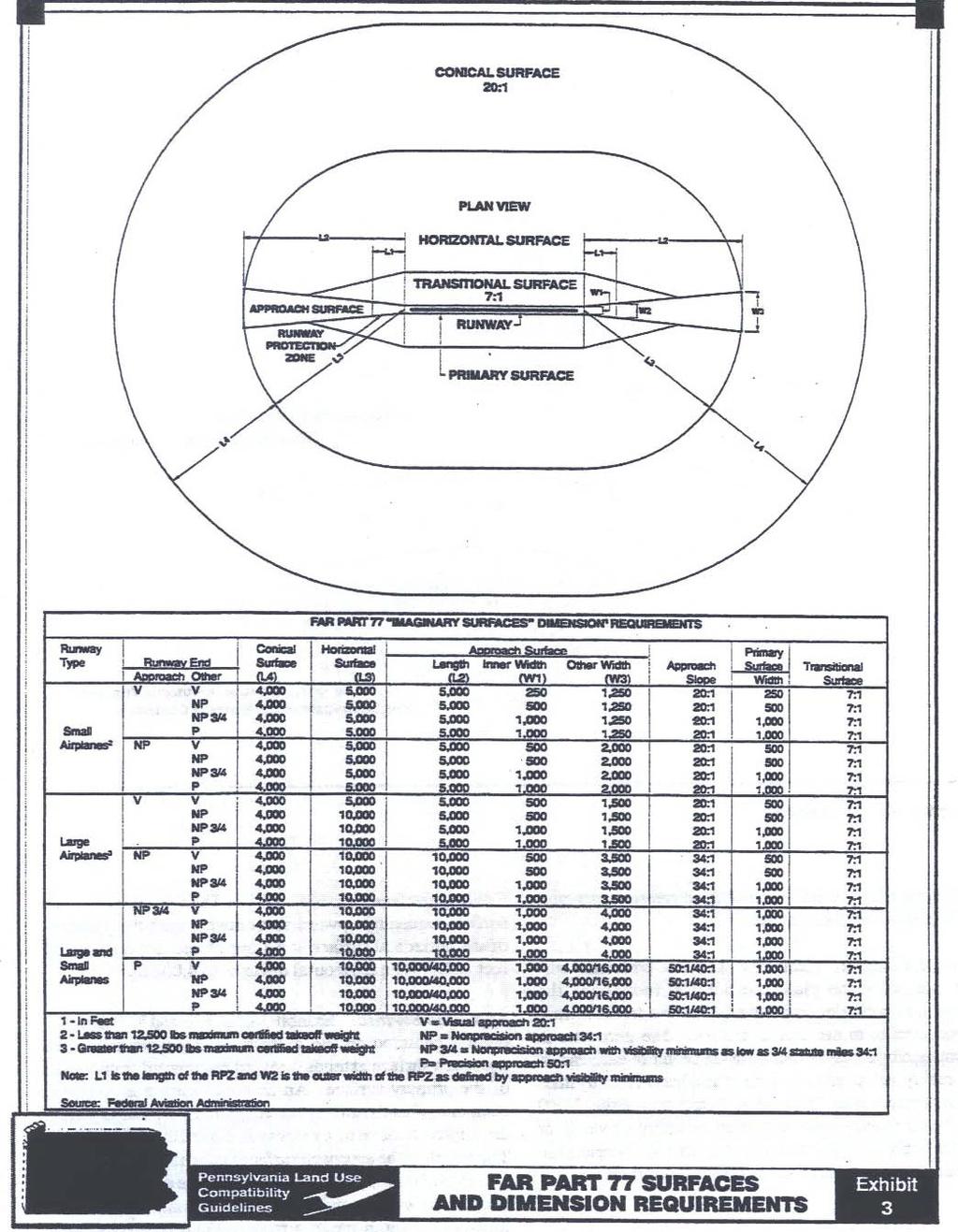
2 Section 301. Relation to Other Zoning Districts A. The Airport Zoning Overlay District shall not modify the boundaries of any other overlay zoning district. Where identified, the Airport Zoning Overlay District shall impose certain requirements on land use, construction and development in addition to those contained in the applicable underlying zoning district and/or applicable overlay zoning district for the same area. Section 401. Definitions The following words and phrases when used in this ordinance shall have the meaning given to them in this section unless the context clearly indicates otherwise. AIRPORT(S) HARRISBURG INTERNATIONAL AIRPORT (MDT) AND CAPITAL CITY AIRPORT (CXY): Any area of land or water which is used, or intended to be use, for the landing and takeoff of aircraft and any appurtenant areas which are used, or intended to be used, for airport buildings or air navigation facilities for rights-of-way, together with all airport buildings and facilities thereon. As used herein, the term Airport includes public airports, but excludes private airports and heliports. Public and private airports are defined separately in this section. Airport Elevation: The highest point of an airport s useable landing area measured in feet above sea level. The Airport elevation for Harrisburg International Airport is three hundred ten (310) feet; the Airport Elevation for Capital City Airport is three hundred forty seven (347) feet. Airport Hazard: Any structure or object, natural or manmade, or use of land which obstructs the airspace required for flight or aircraft in landing or taking off at an airport or is otherwise hazardous as defined in 14 CFR Part 77 and 74 Pa. Cons. Stat Airport Hazard Area: Any area of land or water upon which an airport hazard might be established if not prevented as provided for in this Ordinance and the Act 164 of 1984 (Pennsylvania Laws Relating to Aviation). Approach Surface (Zone): An imaginary surface longitudinally centered on the extended runway centerline and extending outward and upward from each end of the primary surface. An approach surface is applied to each end of the runway based on the planned approach. The inner edge of the approach surface is the same width as the primary surface and expands uniformly depending on the planned approach. The approach surface zone, as shown on Figure 1, is derived from the approach surface. Conical Surface (Zone): An imaginary surface extending outward and upward from the periphery of the horizontal surface at a slope of twenty (20) feet horizontally to one (1) foot
3 vertically for a horizontal distance of four thousand (4,000) feet. The conical surface zone, as shown on Figure 1, is based on the conical surface. Department: Pennsylvania Department of Transportation. FAA: Federal Aviation Administration of the United States Department of Transportation. Height: For the purpose of determining the height limits in all zones set forth in this Ordinance and shown on the zoning map, the datum shall be mean sea level elevation unless otherwise specified. Horizontal Surface (Zone): An imaginary plane 150 feet above the established airport elevation that is constructed by swinging arcs of various radii from the center of the end of the primary surface and then connecting the adjacent arc by tangent lines. The radius of each arc is based on the planned approach. The horizontal surface zone, as shown on Figure 1, is derived from the horizontal surface. Larger Than Utility Runway: A runway that is constructed for and intended to be used by propeller driven aircraft of greater than 12,500 pounds maximum gross weight and jet powered aircraft. Nonconforming Use: Any pre-existing structure, object of natural growth, or use of land which is inconsistent with the provisions of this Ordinance or an amendment thereto. Non-Precision Instrument Runway: A runway having an existing instrument approach procedure utilizing air navigation facilities with only horizontal guidance, or area type navigation equipment, for which a straight-in non-precision instrument approach procedure has been approved or planned. Obstruction: Any structure, growth, or other object, including a mobile object, which exceeds a limiting height set forth by this Ordinance. Precision Instrument Runway: A runway having an existing instrument approach procedure utilizing an Instrument Landing System (ILS) or a Precisions Approach Radar (PAR). It also means a runway for which a precision approach system is planned and is so indicated on an approved airport layout plan or any other planning document. Primary Surface (Zone): An imaginary surface longitudinally centered on the runway, extending 200 feet beyond the end of paved runways or ending at each end of turf runways. The elevation of any point on the primary surface is the same as the elevation of the nearest point on the runway centerline. The primary surface zone, as shown on Figure 1, is derived from the primary surface. Runway: A defined area of an airport prepared for landing and takeoff of aircraft along its length.
4 Structure: An object, including a mobile object, constructed or installed by man, including but without limitation, buildings, towers, cranes, smokestacks, earth formation and overhead transmission lines. Transitional Surface (Zone): An imaginary surface that extends outward and upward from the edge of the primary surface to the horizontal surface at a slope of seven (7) feet horizontally to one (1) foot vertically (7:1). The transitional surface zone, as shown on Figure 1, is derived from the transitional surface. Tree: Any object of natural growth. Utility Runway: A runway that is constructed for and intended to be used by propeller driven aircraft of 12,500 pounds maximum gross weight or less. Visual Runway: A runway intended solely for the operation of aircraft using visual approach procedures. Section 501. Conflict A. Wherever and whenever the requirements of this Part are at variance with the requirements of any other Part and/or Section of this Chapter, the most restrictive, or that imposing the higher standards shall govern. Section 601. Establishment of Airport Zones A. There are hereby created and established certain zones within the Airport Zoning Overlay District, defined in Article 2 of this Chapter and depicted on Figure 1 and illustrated on the Conewago Township, Dauphin County, PA: Airport Zoning Overlay District Map as follows: 1. Approach Surface Zone. 2. Conical Surface Zone. 3. Horizontal Surface Zone. 4. Primary Surface Zone. 5. Transitional Surface Zone. Figure 1: Part 77 Surface Areas
5
6 Section 701. Permit Applications A. As regulated by Act 164 and defined by 14 Code of Federal Regulations Part 77.9(2) (as amended or replaced), proposals for applications to: 1. erect a new structure; 2. add to or increase the height of an existing structure; or 3. establish, erect, and/or maintain any use, structure, or object (natural or manmade), in the Airport Zoning Overlay District: shall first notify the Department s Bureau of Aviation (BOA) by submitting PENNDOT Form AV-57 to obtain an obstruction review of the proposal at least 30 days prior to commencement thereof. In addition, a Conewago Township permit application must be submitted for any structure, object, or modification to an existing structure that would exceed one-hundred (100) feet above ground level. The Department s BOA response must be included with this permit application for it to be considered complete. If the Department s BOA returns a determination of no penetration of airspace, the permit request should be considered in compliance with the intent of this Overlay Ordinance. If the Department s BOA returns a determination of a penetration of airspace, the permit shall be denied, and the project sponsor may seek a variance from such regulations as outlined in Section Variance. B. Exceptions. In the following circumstances notification of an approval by PennDOT s Bureau of Aviation (BOA) shall not be required: 1. In areas lying within the overlay zone, no permit shall be required for any tree or structure less than one-hundred (100) feet of vertical height above the ground, except then, because of terrain, land contour or topographic features, such tree or structure would extend above the height limit prescribed for such approach zones. 2. No permit is required to make maintenance repairs to or to replace parts of existing structures which do not enlarge or increase the height of an existing structure. Section 801. Variances A. In addition to the provisions set forth in Part 17 of this Chapter relating to variances, Any request for a variance shall include documentation in compliance with 14 Code of Federal Regulations Part 77 Subpart B (FAA Form as amended or replaced). Determinations of whether to grant a variance will depend on the determinations made by the FAA and the Department s BOA as to the effect of the proposal on the operation of air navigation facilities and the safe, efficient use of navigable air space. In particular, the request for a variance shall consider which of the following categories the FAA has placed the proposed construction in:
7 1. No Objection - The subject construction is determined not exceed obstruction standards and marking/lighting is not required to mitigate potential hazard. Under this determination a variance shall be granted. 2. Conditional Determination - The proposed construction/alteration is determined to create some level of encroachment into an airport hazard area which can be effectively mitigated. Under this determination, a variance shall be granted contingent upon implementation of mitigating measures as described in Section 1101, Obstruction Marking and Lighting. 3. Objectionable - The proposed construction/alteration is determined to be a hazard and is thus objectionable. A variance shall be denied and the reasons for this determination shall be outlined to the applicant. B. Such requests for variances shall be granted where it is duly found that a literal application or enforcement of the regulations will result in unnecessary hardship and that relief granted will not be contrary to the public interest, will not create a hazard to air navigation, will do substantial justice, and will be in accordance with the intent of this ordinance. Section 901. Use Restrictions A. Notwithstanding any other provisions of this Ordinance, no use shall be made of land or water within the Airport District Overlay in such a manner as to: 1. create electrical interference with navigational signals or radio communications between the airport and aircraft; 2. make it difficult for pilots to distinguish between airport lights and others; 3. impair visibility in the vicinity of the airport; 4. create bird strike hazards; or 5. otherwise endanger or interfere with the landing, takeoff or maneuvering of aircraft utilizing the airport(s). Section Pre-Existing Non-Conforming Uses A. The regulations prescribed by this Ordinance shall not be construed to require the removal, lowering, or other change or alteration of any structure or tree not conforming to the regulations as of the effective date of this Ordinance, or otherwise interfere with the continuance of a non-conforming use. No non-conforming use shall be structurally altered or permitted to grow higher, so as to increase the non-conformity, and a nonconforming use, once substantially abated (subject to the underlying zoning ordinance,) may only be reestablished consistent with the provisions herein. Section Obstruction Marking and Lighting A. Any permit or variance granted pursuant to the provisions of this ordinance may be conditioned according to the process described in Section 801. Variance, to require the
8 owner of the structure or object of natural growth in question to permit the municipality, at its own expense, or require the person requesting the permit or variance, to install, operate, and maintain such marking or lighting as deemed necessary to assure both ground and air safety. Section Conflict or Inconsistency With Other Ordinances A. The provisions of this Ordinance shall supersede the provisions of any other Township Ordinances to the extent of any conflicting or inconsistent provisions. Section Adoption This Ordinance is hereby enacted and adopted by the Board of Supervisors this day of, 2013, to become effective five (5) days after enactment. TOWNSHIP OF CONEWAGO DAUPHIN COUNTY, PENNSYLVANIA ATTEST: By: Joel Buckley, Chairman By: Secretary
9
AIRPORT ZONING REGULATIONS for the City of McPherson, Kansas
 AIRPORT ZONING REGULATIONS for the City of McPherson, Kansas ARTICLE 1. TITLE, PURPOSE, AUTHORITY AND JURISDICTION 100 Title. These regulations, including the McPherson Airport Zoning Map made a part hereof,
The following criteria shall be applied within the boundaries of the AO District:
 Sec. 419 (a) Purpose AIRPORT OVERLAY DISTRICT (AO) The purpose of the Airport Overlay District is to regulate and restrict the height of structures, objects, or natural growth, regulate the locations of
-NOTE: NOT TO BE USED FOR NAVIGATION PURPOSES-
 APPENDIX 1-B INSTRUMENT APPROACH PROCEDURES March 2010 SKYHAVEN AIRPORT -NOTE: NOT TO BE USED FOR NAVIGATION PURPOSES- -NOTE: NOT TO BE USED FOR NAVIGATION PURPOSES- -NOTE: NOT TO BE USED FOR NAVIGATION
APPENDIX D FEDERAL AVIATION REGULATIONS, PART 77
 APPENDIX D FEDERAL AVIATION REGULATIONS, PART 77 Subparts A through C PART 77 - OBJECTS AFFECTING NAVIGABLE AIRSPACE Subpart A General 77.1 Scope. 77.2 Definition of terms. 77.3 Standards. 77.5 Kinds of
PLANNING AND ZONING MEETING. March 20, 2019 AGENDA. 1. Review Minutes. 1
 PLANNING AND ZONING MEETING March 20, 2019 AGENDA 1. Review Minutes. 1 2. Appointments A. Land Use Map Discussion Horrocks Engineers.. 2 B. Airport Protection Ordinance. 3-8 3. Other Business 4. Adjourn
 Page 1 of 10 ARTICLE XXXIX. HOMESTEAD GENERAL AVIATION AIRPORT ZONING* *Editor's note: Article XXXIX, 33-372--33-387, is derived from Ord. No. 69-38, 1--16, enacted July 9, 1969. Section 17 of said ordinance
Article 11 Airport District
 Cities County A Article 11 Article 11 Section 11.01 Intent (a) A. The A is established to provide for uses, activities, facilities, and structures necessary for the safe and efficient operation of aircraft
ARTICLE 34 AIRPORT HEIGHT COMBINING ZONE (AH) (Amended by Ordinance #295 Effective June 26, 2009)
 (Amended by Ordinance #295 Effective June 26, 2009)") ARTICLE 34 AIRPORT HEIGHT COMBINING ZONE (AH) (Amended by Ordinance #295 Effective June 26, 2009) Section 34.10 - Purpose and Intent The purpose of the Airport Height Combining Zone (AH) is to protect
ARTICLE 34 AIRPORT HEIGHT COMBINING ZONE (AH) (Amended by Ordinance #295 Effective June 26, 2009) Section 34.10 - Purpose and Intent The purpose of the Airport Height Combining Zone (AH) is to protect
SITE ELEVATION AMSL...Ground Elevation in feet AMSL STRUCTURE HEIGHT...Height Above Ground Level OVERALL HEIGHT AMSL...Total Overall Height AMSL
 ******************************************** * Federal Airways & Airspace * * Summary Report * ******************************************** File: User Assigned File Name Latitude: NAD83 Coordinate Longitude:
Boise Municipal Code. Chapter DEFINITIONS
 Chapter 12-03 DEFINITIONS Sections: 12-03-01 ADMINISTRATOR 12-03-02 AIRPORT DESIGNATIONS 12-03-03 AIRPORT HAZARD 12-03-04 AIRPORT HEIGHT LIMITATIONS 12-03-05 AIRPORT REFERENCE POINT 12-03-06 AIRPORT INSTRUMENT
Chapter AIRPORT ZONING
 Chapter 142 - AIRPORT ZONING ARTICLE I. - IN GENERAL Sec 142-1 Applicability The airport protection zoning regulations contained in this Chapter shall be applicable to the areas identified in Exhibit A,
Learning More About: Protecting and Evaluating Airspace for Airports
 Learning More About: Protecting and Evaluating Airspace for Airports Introduction Tall structures, smoke, and Tall Structures rising terrain are just a few conditions that can create hazardous conditions
Contents. Page 1 of 11 / Draft Chapter 142 Version CHAPTER AIRPORT ZONING... 2 ARTICLE I. - IN GENERAL... 2
 Contents CHAPTER 142 - AIRPORT ZONING... 2 ARTICLE I. - IN GENERAL... 2 Sec 142-1. - Applicability... 2 Secs. 142-2 142-35. - Reserved.... 3 ARTICLE II. - ST. PETERSBURG-CLEARWATER INTERNATIONAL AIRPORT
AIRSPACE PROTECTION. Guidance and considerations for development in the vicinity of Ohio s airports and heliports
 AIRSPACE PROTECTION Guidance and considerations for development in the vicinity of Ohio s airports and heliports UPDATED SPRING 2018 AIRSPACE PROTECTION When construction is proposed near public use airports
Airport Zoning Regulations
 Airport Zoning Regulations Tampa International Airport Tampa Executive Airport Peter O. Knight Airport Plant City Airport Hillsborough County Aviation Authority June 1, 2017 TABLE OF CONTENTS Page Section
TITLE 16. DEPARTMENT OF TRANSPORTATION CHAPTER 62. AIR SAFETY AND ZONING
 NOTE: This is a courtesy copy of this rule. The official version can be found in the New Jersey Administrative Code. Should there be any discrepancies between this text and the official version, the official
ARTICLE 16 AIRPORT REGULATIONS
 ARTICLE 16 AIRPORT REGULATIONS CHAPTER A GENERAL... 3 Section 1 Purpose and Intent... 3 Section 2 Short Title and Authority... 3 Section 3 Applicability... 3 Section 4 Definitions and Acronyms... 3 CHAPTER
Airport Obstruction Standards
 Airport Obstruction Standards Dr. Antonio Trani Department of Civil and Environmental Engineering Virginia Tech Outline of this Presentation Obstructions to navigation around airports Discussion of Federal
Appendix C AIRPORT LAYOUT PLANS
 Appendix C AIRPORT LAYOUT PLANS Appendix C AIRPORT LAYOUT PLANS Airport Master Plan Santa Barbara Airport As part of this Airport Master Plan, the Federal Aviation Administration (FAA) requires the development
PART III CODE OF ORDINANCES Chapter 33 ZONING
 ARTICLE XL. - KENDALL TAMIAMI EXECUTIVE AIRPORT ZONING Sec. 33-388. - Short title. Sec. 33-389. - Provisions hereof established as minimum standards governing zoning. Sec. 33-390. - Definitions. Sec. 33-391.
Chapter Six ALP Drawings. Tacoma Narrows Airport. Master Plan Update
 Chapter Six ALP Drawings Master Plan Update The master planning process for the (Airport) has evolved through efforts in the previous chapters to analyze future aviation demand, establish airside and landside
SUBCHAPTER E AIRSPACE
 PART 71 DESIGNATION OF CLASS A, B, C, D, AND E AIRSPACE AREAS; AIR TRAFFIC SERVICE ROUTES; AND REPORTING POINTS Sec. SPECIAL FEDERAL AVIATION REGULATION NO. 97 [NOTE] 71.1 Applicability. 71.3 [Reserved]
Flying Cloud Airport (FCM) Zoning Process: Informing a Mn/DOT Path Forward
 Zoning Process: Informing a Mn/DOT Path Forward") : Informing a Mn/DOT Path Forward A Review of the Flying Cloud Airport (FCM) Joint Airport Zoning Board (JAZB) Process and the Draft Airport Zoning Ordinance B A RPZ RPZ A B C Zone Chad E. Leqve Director
: Informing a Mn/DOT Path Forward A Review of the Flying Cloud Airport (FCM) Joint Airport Zoning Board (JAZB) Process and the Draft Airport Zoning Ordinance B A RPZ RPZ A B C Zone Chad E. Leqve Director
NOTICE TO PROPOSED CITY PERMITS: ZONING HEIGHT RESTRICTIONS/APPROVAL PROCESS
 NOTICE TO PROPOSED CITY PERMITS: ZONING HEIGHT RESTRICTIONS/APPROVAL PROCESS Dear Prospective Permittee: The City of St Petersburg (City) issues permits for construction projects based on local and state
Mapleton Municipal Airport, Mapleton, Iowa Monona County, Iowa
 Monona County Ordinance No. 53 Chapter 300(b) Airport Land Use and Height Overlay Zoning Ordinance Mapleton Municipal Airport, Mapleton, Iowa Monona County, Iowa Table of Contents Section 1. Introduction
RULES OF TENNESSEE DEPARTMENT OF TRANSPORTATION AERONAUTICS DIVISION CHAPTER LICENSING AND REGISTRATION OF AIRPORTS TABLE OF CONTENTS
 RULES OF TENNESSEE DEPARTMENT OF TRANSPORTATION AERONAUTICS DIVISION CHAPTER 1680-1-2 LICENSING AND REGISTRATION OF AIRPORTS TABLE OF CONTENTS 1680-1-2-.01 Purpose 1680-1-2-.06 Repealed 1680-1-2-.02 Definitions
Consideration will be given to other methods of compliance which may be presented to the Authority.
 Advisory Circular AC 139-10 Revision 1 Control of Obstacles 27 April 2007 General Civil Aviation Authority advisory circulars (AC) contain information about standards, practices and procedures that the
DRAFT MASTER PLAN UPDATE
 DRAFT MASTER PLAN UPDATE CHAPTER VI: AIRPORT LAYOUT PLAN NARRATIVE DRAFT REPORT APRIL 2017 PREPARED BY: Table of Contents WESTCHESTER COUNTY AIRPORT 6 AIRPORT LAYOUT PLAN NARRATIVE REPORT... 6-1 6.1 AGIS
AIRPORT LAND USE COMPATILIBILTY AIRPORT LAND USE COMPATIBILIITY
 CHAPTER 7 AIRPORT LAND USE COMPATILIBILTY CHAPTER 7 AIRPORT LAND USE COMPATIBILIITY 7.0 INTRODUCTION On airport aviation related development is typically compatible with aircraft operations. On airport
AVIATION PLANNING AND DEVELOPMENT Oakland International Airport 530 Water Street Oakland, CA 94607
 AVIATION PLANNING AND DEVELOPMENT Oakland International Airport 530 Water Street When Do I Need to File an FAA Form 7460-1? Objects Affecting Navigable Airspace (14CFR77) June 2013 Background The Federal
Overview ICAO Standards and Recommended Practices for Aerodrome Safeguarding
 Overview ICAO Standards and Recommended Practices for Aerodrome Safeguarding References The Convention on International Civil Aviation (Chicago Convention) ICAO SARPS Annex 14 Vol. I, 7 th Edition, July
Part 77 CAA Consolidation 1 April 2014 Objects and Activities Affecting Navigable Airspace
 Part 77 CAA Consolidation 1 April 2014 Objects and Activities Affecting Navigable Airspace Published by the Civil Aviation Authority of New Zealand DESCRIPTION Part 77 prescribes rules for persons proposing
ARTICLE III: LAND USE DISTRICTS 385 PRIVATE USE AIRPORT OVERLAY DISTRICT
 ARTICLE III: LAND USE DISTRICTS 385 PRIVATE USE AIRPORT OVERLAY DISTRICT III 265 385 PRIVATE USE AIRPORT OVERLAY DISTRICT 385 1 Purpose The purpose of the Private Use Airport Overlay District is to recognize
AIR NAVIGATION ORDER
 CLEARANCE AREAS AND OBSTACLE LIMITATION SURFACES AT AIR NAVIGATION ORDER VERSION : 2.0 DATE OF IMPLEMENTATION : 15-02-2013 OFFICE OF PRIME INTEREST : AERODROME STANDARDS BRANCH. (Directorate of Airspace
It is essential that planning take full account of air safety and efficiency of operations.
 Airspace Protection Airspace Protection It is essential that planning take full account of air safety and efficiency of operations. 7.1 INTRODUCTION Obstacles near an airport, whether they are natural
FAA Requirements for Engine-out Procedures and Obstacle Clearance
 FAA Requirements for Engine-out Procedures and Obstacle Clearance Presentation to: CAAC Engine-out Procedures Seminar Name: Chuck Friesenhahn Date: 11/29/2005 Flight Standards Senior Advisor, Advanced
Transportation Chapter ALABAMA DEPARTMENT OF TRANSPORTATION ADMINISTRATIVE CODE CHAPTER DEFINITIONS TABLE OF CONTENTS
 Transportation Chapter 450-9-2 ALABAMA DEPARTMENT OF TRANSPORTATION ADMINISTRATIVE CODE CHAPTER 450-9-2 DEFINITIONS TABLE OF CONTENTS 450-9-2-.01 Definitions 450-9-2-.01 Definitions. For the purpose of
APPENDIX F LAND USE PLANNING FOR AIRPORTS AND POCATELLO REGIONAL AIRPORT LAND USE COMPLIANCE
 APPENDIX F LAND USE PLANNING FOR AIRPORTS AND POCATELLO REGIONAL AIRPORT LAND USE COMPLIANCE Pocatello Regional Airport Airport Master Plan APPENDIX F LAND USE PLANNING FOR AIRPORT AND POCATELLO REGIONAL
Rule Governing the Designation and Establishment of All-Terrain Vehicle Use Trails on State Land
 Rule Governing the Designation and Establishment of All-Terrain Vehicle Use Trails on State Land 1.0 Authority 1.1 This rule is promulgated pursuant to 23 V.S.A. 3506. Section 3506 (b)(4) states that an
** DETERMINATION OF NO HAZARD TO AIR NAVIGATION **
 Mail Processing Center Federal Aviation Administration Southwest Regional Office Obstruction Evaluation Group 2601 Meacham Boulevard Fort Worth, TX 76137 Issued Date: 05/16/2011 Aeronautical Study No.
Chapter 9 - AIRPORT SYSTEM DESIGN
 Chapter 9 - AIRPORT SYSTEM DESIGN 9.01 GENERAL This chapter discusses the development program for Dutchess County Airport to the year 2020. This airport system design is based upon the airport's existing
ORDINANCE #29 OSCEOLA MUNICIPAL AIRPORT LAND USE AND HEIGHT OVERLAY ZONING ORDINANCE
 Section 1-Title ORDINANCE #29 OSCEOLA MUNICIPAL AIRPORT LAND USE AND HEIGHT OVERLAY ZONING ORDINANCE This Ordinance shall be known and may be cited as THE OSCEOLA MUNICIPAL AIRPORT LAND USE & HEIGHT OVERLAY
Ordinance No Amendments to Airport Ordinance 87-8
 SECTION 1. SUMMARY. This Ordinance adds various provisions to uncodified County Ordinance 87-8 ("the Airport Regulations"), amends and renumbers various provisions of the Airport Regulations, and adds
CHAPTER 61 SHEBOYGAN COUNTY MEMORIAL AIRPORT
 61.01 OPERATION OF AIRPORT 61.02 DEFINITION OF WORDS AND PHRASES 61.03 AIRPORT OPERATION POLICIES 61.04 UTILITIES 61.05 ENTRANCES 61.06 SPECIAL VARIANCE 61.07 ENFORCEMENT 61.08 PENALTY 61.09 MULTIPLE OWNERSHIP
Electronic Terrain and Obstacle Data
 International Civil Aviation Organization Electronic Terrain and Obstacle Data David Lewtas Chief, Aeronautical Information Unit (MET/AIM) 24 November 2010 ICAO CAR AIM Seminar Kingston, Jamaica 22-24
Notice of Extended Comment Period for an Intent to Adopt a Negative Declaration
 County of Santa Clara Department of Planning and Development Planning Office County Government Center, East Wing, 7 th Floor 70 West Hedding Street San Jose, California 95110-1705 (408) 299-5770 FAX (408)
AMENDMENT No. 8 TO THE INTERNATIONAL STANDARDS AND RECOMMENDED PRACTICES AERODROMES ANNEX 14 TO THE CONVENTION ON INTERNATIONAL CIVIL AVIATION
 AMENDMENT No. 8 TO THE INTERNATIONAL STANDARDS AERODROMES ANNEX 14 TO THE CONVENTION ON INTERNATIONAL CIVIL AVIATION VOLUME I AERODROME DESIGN AND OPERATIONS The amendment to Annex 14, Volume I contained
USE OF 3D GIS IN ANALYSIS OF AIRSPACE OBSTRUCTIONS
 USE OF 3D GIS IN ANALYSIS OF AIRSPACE OBSTRUCTIONS A project by by Samuka D. W. F19/1461/2010 Supervisor; Dr D. N. Siriba 1 Background and Problem Statement The Airports in Kenya are the main link between
UNITED STATES OF AMERICA FEDERAL AVIATION ADMINISTRATION WASHINGTON D.C. GRANT OF EXEMPTION
 In the matter of the petition of the DEPARTMENT OF DEFENSE UNITED STATES OF AMERICA FEDERAL AVIATION ADMINISTRATION WASHINGTON D.C. Exemption No. 5100B For an exemption from the provisions 25863 Of sections
STAFF REPORT. Airport Land Use Plan Consistency Review: Old Town Village Mixed Use Project City of Goleta. MEETING DATE: June 18, 2015 AGENDA ITEM: 5M
 STAFF REPORT SUBJECT: Airport Land Use Plan Consistency Review: Old Town Village Mixed Use Project City of Goleta MEETING DATE: AGENDA ITEM: 5M STAFF CONTACT: Peter Imhof, Andrew Orfila RECOMMENDATION:
Hearings will be held in the Shirley Huffman Auditorium in the Charles D. Cameron Public Services Building, 155 North First Avenue, Hillsboro, Oregon.
 Hearings will be held in the Shirley Huffman Auditorium in the Charles D. Cameron Public Services Building, 155 North First Avenue, Hillsboro, Oregon. On September 24, 2013, the Board of County Commissioners
Reliever Airports: NOISE ABATEMENT PLAN Flying Cloud Airport (FCM)
") Reliever Airports: NOISE ABATEMENT PLAN Flying Cloud Airport (FCM) INTRODUCTION The Noise Abatement Plan (FCM Plan) for the Flying Cloud Airport has been prepared in recognition of the need to make the
Reliever Airports: NOISE ABATEMENT PLAN Flying Cloud Airport (FCM) INTRODUCTION The Noise Abatement Plan (FCM Plan) for the Flying Cloud Airport has been prepared in recognition of the need to make the
INTEROFFICE MEMORANDUM
 INTEROFFICE MEMORANDUM TO: CITY COUNCIL, AIRPORT COMMITTEE, AND PLANNING ADVISORY COMMITTEE FROM: MELISSA ROMÁN SUBJECT: 2017 AIRPORT MASTER PLAN UPDATE EXECUTIVE SUMMARY DATE: APRIL 18, 2017 As part of
AERODROME LICENCE APPLICATION PROCESS
 0000180111 Page 2 Why is a Licence Required? An aerodrome licence is required for a site if it is intended to facilitate operations by commercial transport aircraft, other aerial work other than rotorcraft,
AERONAUTICAL SURVEYS & INSTRUMENT FLIGHT PROCEDURES
 AERONAUTICAL SURVEYS & INSTRUMENT FLIGHT PROCEDURES Current as of November 2012 ALASKA AVIATION SYSTEM PLAN UPDATE Prepared for: State of Alaska Department of Transportation & Public Facilities Division
AIRPORTS POLICY 28, AIRPORTS:
 AIRPORTS POLICY 28, AIRPORTS: It is the policy of Washington County to protect the function and economic viability of existing public use airports, while ensuring public safety and compatibility between
AIRWORTHINESS CERTIFICATION OF AIRCRAFT AND RELATED PRODUCTS. 1. PURPOSE. This change is issued to incorporate revised operating limitations.
 8130.2D 2/15/00 AIRWORTHINESS CERTIFICATION OF AIRCRAFT AND RELATED PRODUCTS 1. PURPOSE. This change is issued to incorporate revised operating limitations. 2. DISTRIBUTION. This change is distributed
APPENDIX K LAND USE. Charles M. Schulz - Sonoma County Airport Draft Environmental Impact Report July 2011 K-1
 APPENDIX K LAND USE Charles M. Schulz - Sonoma County Airport Draft Environmental Impact Report July 2011 K-1 Appendix K Land Use THIS PAGE INTENTIONALLY LEFT BLANK Charles M. Schulz - Sonoma County Airport
FAA FORM UAS COA Attachment FAA
 Page 1 of 6 DEPARTMENT OF TRANSPORTATION FEDERAL AVIATION ADMINISTRATION CERTIFICATE OF WAIVER OR AUTHORIZATION ISSUED TO Xcam Aerials, Inc. 10197 SE 144th Place Summerfield, FL 34491 This certificate
Democratic Socialist Republic of Sri Lanka. Implementing Standards (Issued under Sec. 120, Civil Aviation Act No. 14 of 2010)
") Democratic Socialist Republic of Sri Lanka Civil Aviation Authority of Sri Lanka Implementing Standards (Issued under Sec. 120, Civil Aviation Act No. 14 of 2010) Title: Requirements for Operation of Pilotless
Democratic Socialist Republic of Sri Lanka Civil Aviation Authority of Sri Lanka Implementing Standards (Issued under Sec. 120, Civil Aviation Act No. 14 of 2010) Title: Requirements for Operation of Pilotless
UNITED STATES OF AMERICA FEDERAL AVIATION ADMINISTRATION WASHINGTON D.C. GRANT OF EXEMPTION
 In the matter of the petition of the DEPARTMENT OF DEFENSE UNITED STATES OF AMERICA FEDERAL AVIATION ADMINISTRATION WASHINGTON D.C. Exemption No. 5100C For an exemption from the provisions 25863 Of sections
EXPERIMENTAL OPERATING LIMITATIONS EXHIBITION GROUP I1
 US. Department of Transportatlon Federal Aviation Administration MA[. 2 3 2000 Flight Standards District Office EXPERIMENTAL OPERATING LIMITATIONS EXHIBITION GROUP I1 Registration No:N7237K Make:Bell Model:206A-l
USE OF RADAR IN THE APPROACH CONTROL SERVICE
 USE OF RADAR IN THE APPROACH CONTROL SERVICE 1. Introduction The indications presented on the ATS surveillance system named radar may be used to perform the aerodrome, approach and en-route control service:
Part 77 and Construction
 Part 77 and Construction Presented to: By: Date: Advanced ASOS Steven Oetzell October 18, 2016 14 CFR Part 77, Objects Affecting Navigable Airspace Reporting objects to the FAA 14 CFR Part 139.331 states
TANZANIA CIVIL AVIATION AUTHORITY AIR NAVIGATION SERVICES INSPECTORATE. Title: CONSTRUCTION OF VISUAL AND INSTRUMENT FLIGHT PROCEDURES
 Page 1 of 8 1. PURPOSE 1.1. This Advisory Circular provides guidance to personnel involved in construction of instrument and visual flight procedures for publication in the Aeronautical Information Publication.
STAFF REPORT. Airport Land Use Consistency Determination Betteravia Plaza. MEETING DATE: January 21, 2016 AGENDA ITEM: 8D
 STAFF REPORT SUBJECT: Airport Land Use Consistency Determination Betteravia Plaza MEETING DATE: AGENDA ITEM: 8D STAFF CONTACT: Andrew Orfila RECOMMENDATION: Adopt findings for the Betteravia Plaza project
EAGLE RIVER UNION AIRPORT HANGAR CONSTRUCTION GUIDELINES Approved 1/29/2008
 EAGLE RIVER UNION AIRPORT HANGAR CONSTRUCTION GUIDELINES Approved 1/29/2008 SECTION 1 - PURPOSE AND SCOPE 1.1 Purpose This document is designed to serve as a guide for private and commercial hangar construction
Administration Policies & Procedures Section Commercial Ground Transportation Regulation
 OBJECTIVE METHOD OF OPERATION Definitions To promote and enhance the quality of Commercial Ground Transportation, the public convenience, the safe and efficient movement of passengers and their luggage
UNITED STATES OF AMERICA DEPARTMENT OF TRANSPORTATION OFFICE OF AVIATION ENFORCEMENT AND PROCEEDINGS WASHINGTON, DC. March 4, 2015
 UNITED STATES OF AMERICA DEPARTMENT OF TRANSPORTATION OFFICE OF AVIATION ENFORCEMENT AND PROCEEDINGS WASHINGTON, DC March 4, 2015 Answers to Frequently Asked Questions Concerning Enforcement of the Musical
AIRPORT NOISE AND CAPACITY ACT OF 1990
 AIRPORT NOISE AND CAPACITY ACT OF 1990 P. 479 AIRPORT NOISE AND CAPACITY ACT OF 1990 SEC. 9301. SHORT TITLE This subtitle may be cited as the Airport Noise and /Capacity Act of 1990. [49 U.S.C. App. 2151
Flying Cloud Airport Joint Airport Zoning Board. 27 February 2018 Public Hearing #1 Overview of Proposed Airport Zoning Ordinance
 Flying Cloud Airport Joint Airport Zoning Board 27 February 2018 Public Hearing #1 Overview of Proposed Airport Zoning Ordinance Presentation Agenda Purpose & Goals Review of FCM Zoning Historical Timeline
Administration Policies & Procedures Section Commercial Ground Transportation Regulation
 OBJECTIVE METHOD OF OPERATION Definitions To promote and enhance the quality of Commercial Ground Transportation, the public convenience, the safe and efficient movement of passengers and their luggage
PROPOSED INVERCARGILL CITY DISTRICT PLAN. Decision No. 28G. Invercargill Airport Ltd Designations
 PROPOSED INVERCARGILL CITY DISTRICT PLAN Decision No. 28G Invercargill Airport Ltd Designations Hearings Committee Councillor Darren Ludlow (Chair) Councillor Neil Boniface Councillor Graham Sycamore Keith
** DETERMINATION OF NO HAZARD TO AIR NAVIGATION **
 Federal Aviation Administration Air Traffic Airspace Branch, ASW-520 2601 Meacham Blvd. Fort Worth, TX 76137-0520 Aeronautical Study No. 2010-WTE-13969-OE Issued Date: 09/30/2010 Morgan Johnston University
GOVERNMENT OF INDIA OFFICE OF DIRECTOR GENERAL OF CIVIL AVIATION
 GOVERNMENT OF INDIA OFFICE OF DIRECTOR GENERAL OF CIVIL AVIATION ANSS AC NO. 1 of 2017 31.07. 2017 Air Space and Air Navigation Services Standard ADVISORY CIRCULAR Subject: Procedures to follow in case
** DETERMINATION OF NO HAZARD TO AIR NAVIGATION **
 Mail Processing Center Federal Aviation Administration Southwest Regional Office Obstruction Evaluation Group 2601 Meacham Boulevard Fort Worth, TX 76137 Issued Date: 01/04/2012 Aeronautical Study No.
APPENDIX F AIRSPACE INFORMATION
 APPENDIX F AIRSPACE INFORMATION Airspace Use DEFINITION OF AIRSPACE Airspace, or that space which lies above a nation and comes under its jurisdiction, is generally viewed as being unlimited. However,
FACILITY REQUIREMENTS SUMMARY OF KEY ISSUES OVERVIEW
 FACILITY REQUIREMENTS SUMMARY OF KEY ISSUES OVERVIEW This summary is intended to provide a brief overview of the key issues associated with conformance to FAA standards at Methow Valley State Airport.
NOISE ABATEMENT PROCEDURES
 1. Introduction NOISE ABATEMENT PROCEDURES Many airports today impose restrictions on aircraft movements. These include: Curfew time Maximum permitted noise levels Noise surcharges Engine run up restrictions
EAST GOSHEN TOWNSHIP CHESTER COUNTY, PENNSYLVANIA ORDINANCE NO
 EAST GOSHEN TOWNSHIP CHESTER COUNTY, PENNSYLVANIA ORDINANCE NO. 129-8-2015 AN ORDINANCE OF EAST GOSHEN TOWNSHIP REGULATING THE USE AND OPERATION OF MODEL AIRCRAFT AND AMATEUR ROCKETS IN THE TOWNSHIP. WHEREAS,
Effective Altitude. R-3103 To 30,000 (To 9,144 meters) Source: NACO 2002 Notes: 1 By NOTAM issued 12 hours in advance
 Source: NACO 2002 Notes: 1 By NOTAM issued 12 hours in advance") 8.4 AIRSPACE USE 8.4.1 Affected Environment The affected airspace environment is described below in terms of its principal attributes, namely controlled and uncontrolled airspace, special use airspace,
8.4 AIRSPACE USE 8.4.1 Affected Environment The affected airspace environment is described below in terms of its principal attributes, namely controlled and uncontrolled airspace, special use airspace,
Control of Cranes and Other Temporary Obstacles
 United Kingdom Overseas Territories Aviation Circular OTAC 139-27 140-11 171-8 172-11 178-10 Control of Cranes and Other Temporary Obstacles Issue 1 1 June 2018 Effective on issue GENERAL Overseas Territories
HENDRY COUNTY PLANNING & ZONING DEPARTMENT POST OFFICE BOX SOUTH MAIN STREET LABELLE, FLORIDA (863) FAX: (863)
 FAX: (863)") HENDRY COUNTY PLANNING & ZONING DEPARTMENT POST OFFICE BOX 2340 640 SOUTH MAIN STREET LABELLE, FLORIDA 33975 (863) 675-5240 FAX: (863) 674-4194 HENDRY COUNTY LOCAL PLANNING AGENCY May 2, 2018 Hendry County
HENDRY COUNTY PLANNING & ZONING DEPARTMENT POST OFFICE BOX 2340 640 SOUTH MAIN STREET LABELLE, FLORIDA 33975 (863) 675-5240 FAX: (863) 674-4194 HENDRY COUNTY LOCAL PLANNING AGENCY May 2, 2018 Hendry County
Noble Energy, Inc. MX3501-N Communication Tower. FAA and FCC Data
 Noble Energy, Inc. MX3501-N Communication Tower FAA and FCC Data Submitted to: Garfield County Building & Planning Department OA Project No. 011-2632 January 10, 2012 Notice Criteria Tool https://oeaaa.faa.gov/oeaaa/external/gistools/gisaction.jsp?action=dononoticerequired...
Planning Challenges and Solutions
 2007 AirTAP Fall Forum Planning Challenges and Solutions Matt Romanik Past Interim Airport Manager, Grand Rapids Itaska County Airport Gina Mitchell Planner, Bolton & Menk Inc. Kathy Vesely Zoning Coordinator
STATUTORY INSTRUMENTS. S.I. No. 855 of 2004 IRISH AVIATION AUTHORITY (AIR TRAFFIC SERVICE SYSTEMS) ORDER, 2004
 ORDER, 2004") STATUTORY INSTRUMENTS S.I. No. 855 of 2004 IRISH AVIATION AUTHORITY (AIR TRAFFIC SERVICE SYSTEMS) ORDER, 2004 PUBLISHED BY THE STATIONERY OFFICE DUBLIN To be purchased directly from the GOVERNMENT PUBLICATIONS
STATUTORY INSTRUMENTS S.I. No. 855 of 2004 IRISH AVIATION AUTHORITY (AIR TRAFFIC SERVICE SYSTEMS) ORDER, 2004 PUBLISHED BY THE STATIONERY OFFICE DUBLIN To be purchased directly from the GOVERNMENT PUBLICATIONS
Civil Aviation Rules, 2052 (1996)
") Civil Aviation Rules, 2052 (1996) Date of Publication in Nepal Gazette Amendment: 2052.9.24 (8 Jan. 1996) Civil Aviation (First Amendment) Rules, 2058 2058.4.32 (16 Aug. 2001) Government of Nepal has made
Civil Aviation Rules, 2052 (1996) Date of Publication in Nepal Gazette Amendment: 2052.9.24 (8 Jan. 1996) Civil Aviation (First Amendment) Rules, 2058 2058.4.32 (16 Aug. 2001) Government of Nepal has made
(a) This part prescribes rules governing the operation in the United States, of the following:
 This part prescribes rules governing the operation in the United States, of the following:") PART 101 MOORED BALLOONS, KITES, AMATEUR ROCKETS AND UNMANNED FREE BALLOONS 101.1 Applicability. 101.3 Waivers. 101.5 Operations in prohibited or restricted areas. 101.7 Hazardous operations. Subpart A
PART 101 MOORED BALLOONS, KITES, AMATEUR ROCKETS AND UNMANNED FREE BALLOONS 101.1 Applicability. 101.3 Waivers. 101.5 Operations in prohibited or restricted areas. 101.7 Hazardous operations. Subpart A
Part 406. Certification Procedures. (Effective December 29, 1960
 REGULATIONS OF THE ADMINISTRATOR Federal Aviation Agency - Washington, D.C. Part 406 Certification Procedures (Effective December 29, 1960 SUBCHAPTER A PROCEDURAL REGULATIONS Part 406, Regulations of the
Sample Regulations for Water Aerodromes
 Sample Regulations for Water Aerodromes First Edition (unedited version) March 2015 Notice to users: This document is an unedited version which is made available to the public for convenience. Its content
AIRPORT SAFEGUARDING. Airport safeguarding is specifically concerned with:
 Airport Safeguarding is the process established to ensure that all appropriate measures are taken to secure the safety of aircraft when taking off, landing or flying within the vicinity of an airport.
MINNESOTA AIRPORT LAND USE COMPATIBILITY MANUAL APPENDICES. Methods for Determining Concentrations of People
 APPENDICES Contents MINNESOTA AIRPORT LAND USE COMPATIBILITY MANUAL APPENDICES APPENDIX 1: APPENDIX 2: APPENDIX 3: APPENDIX 4: APPENDIX 5: APPENDIX 6: APPENDIX 7: APPENDIX 8: APPENDIX 9: APPENDIX 10: APPENDIX
Applicant: EUROWINGS LUFTVERKEHRS AG (Eurowings) Date Filed: July 16, 2014
 Date Filed: July 16, 2014") UNITED STATES OF AMERICA DEPARTMENT OF TRANSPORTATION OFFICE OF THE SECRETARY WASHINGTON, D.C. Issued by the Department of Transportation on September 17, 2014 NOTICE OF ACTION TAKEN -- DOCKET DOT-OST-2009-0106
UNITED STATES OF AMERICA DEPARTMENT OF TRANSPORTATION OFFICE OF THE SECRETARY WASHINGTON, D.C. Issued by the Department of Transportation on September 17, 2014 NOTICE OF ACTION TAKEN -- DOCKET DOT-OST-2009-0106
COMMISSION OF THE EUROPEAN COMMUNITIES. Draft. COMMISSION REGULATION (EU) No /
 No /") EN EN EN COMMISSION OF THE EUROPEAN COMMUNITIES Draft Brussels, C COMMISSION REGULATION (EU) No / of [ ] laying down requirements and administrative procedures related to Air Operations pursuant to Regulation
EN EN EN COMMISSION OF THE EUROPEAN COMMUNITIES Draft Brussels, C COMMISSION REGULATION (EU) No / of [ ] laying down requirements and administrative procedures related to Air Operations pursuant to Regulation
PART 101--MOORED BALLOONS, KITES, UNMANNED ROCKETS AND UNMANNED FREE BALLOONS
 PART 101--MOORED BALLOONS, KITES, UNMANNED ROCKETS AND UNMANNED FREE BALLOONS Subpart A--General Sec. 101.1 Applicability. 101.3 Waivers. 101.5 Operations in prohibited or restricted areas. 101.7 Hazardous
(a) it has been licensed for the purpose, and save in accordance with the conditions prescribed in such licence; or
 it has been licensed for the purpose, and save in accordance with the conditions prescribed in such licence; or") PART - XI Aerodromes 78. Licensing of Aerodromes (1) No aerodrome shall be used as a regular place of landing and departure by a scheduled air transport service or for a series of landings and departures
PART - XI Aerodromes 78. Licensing of Aerodromes (1) No aerodrome shall be used as a regular place of landing and departure by a scheduled air transport service or for a series of landings and departures
Chapter 4 Airport Facility Requirements
 Chapter 4 Airport Facility Requirements Introduction CHAPTER 4 AIRPORT FACILITY REQUIREMENTS MAY 2013-1 Organization of Materials CHAPTER 4 AIRPORT FACILITY REQUIREMENTS MAY 2013-2 RPZ - ROAD RPZ - NON-AIRPORT
CHAPTER 5 SEPARATION METHODS AND MINIMA
 CHAPTER 5 SEPARATION METHODS AND MINIMA 5.1 Provision for the separation of controlled traffic 5.1.1 Vertical or horizontal separation shall be provided: a) between IFR flights in Class D and E airspaces
Advanced Rating Study Guide
 Advanced Rating Study Guide FAR Part 103--Ultralight Vehicles FAR Part 91 VFR/IFR Cruise Altitude Windsports Soaring Center 12623 Gridley Street Sylmar, CA 91342-3334 Tel: (818) 367-2430 Fax: (818) 367-5363
General Operating and Flight Rules
 PURSUANT to Sections 28 and 29 of the Civil Aviation Act 1990 I, HARRY JAMES DUYNHOVEN, Minister for Transport Safety, HEREBY MAKE the following ordinary rules. SIGNED AT Wellington This day of 2007 by