|
|
|
- Jacob Knight
- 6 years ago
- Views:
Transcription


1 Brown Field Municipal Airport Land Use Compatibility Plan
2

3
4

5

6
7


8
9 San Diego County Regional Airport Authority Brown Field Municipal Airport Land Use Compatibility Plan Prepared for: San Diego County Regional Airport Authority Prepared by: Ricondo & Associates, Inc. Adopted by the San Diego County Airport Land Use Commission
10
11 San Diego County Regional Airport Authority (as of ) Executive Committee Members Bob Watkins, Chairman Ramona Finnila, Vice Chair Anthony K. Young General Members Bruce R. Boland Jim Desmond Robert Gleason Jim Panknin Tom Smisek John Davies Staff Thella F. Bowens President/CEO Angela Shafer-Payne Vice President, Strategic Planning and Operations Keith B. Wilschetz Director, Airport Planning Sandi Sawa Manager, Airport Planning Kim Sheredy, AICP Airport Planner II Breton K. Lobner General Counsel Amy Gonzalez Director, Counsel Services Lori D. Ballance Outside Legal Counsel
12
13 Table of Contents Brown Field Municipal Airport Chapter 1: Introduction Overview of the Plan Function and Applicability of the Compatibility Plan Statutory Reqirements San Diego County Airport Land Use Commission Relationship of the ALUC to Local Agencies Policy Framework State Laws and Guidelines Relationship to Airport Master Plans Forecasting Methodology Plan Implementation General Plan Consistency Project Referrals Plan Contents Chapter 2: Airport Land Use Commission Policies Chapter Overview Definitions Effective Date Types of Airport Impacts Geographic Scope Types of Actions Reviewed General Review Process for Land Use Actions Review Process for General Plans, Specific Plans, Zoning Ordinances, and Building Regulations General Plan Consistency with Compatibility Plan Review Process for Other Land Use Actions Special Compatibility Considerations Review of Airport Master Plans and Development Plans i
14 TABLE OF CONTENTS BROWN FIELD MUNICIPAL AIRPORT Chapter 3: Brown Field Municipal Airport Policies and Maps Chapter Overview Compatibility Zone Delineation Underlying Airport Data Compatibility Policy Maps Noise Compatibility Policies for Brown Field Municipal Airport Safety Compatibility Policies for Brown Field Municipal Airport Airspace Protection Compatibility Policies for Brown Field Municipal Airport Overflight Compatibility Policies for Brown Field Municipal Airport Chapter 4: Background Data: Brown Field Municipal Airport and Environs Airport Overview Airport Location Airport Facilities Existing Airport Activity Airport Activity Forecast Existing and Future Noise Exposure Contours Airport Environs Compatibility Factors/Layers Compatibility Data: Noise Compatibility Data: Safety Compatibility Data: Airspace Protection Compatibility Data: Overflight Appendices A. State Laws Related to Airport Land Use Planning...A-1 B. 14 Code of Federal Regulations Part 77: Objects Affecting Navigable Airspace... B-1 C. Airport Land use Compatibility Concepts... C-1 ii
15 TABLE OF CONTENTS BROWN FIELD MUNICIPAL AIRPORT D. Methods for Determining Concentrations of People...D-1 E. General Plan Consistency Checklist... E-1 F. Sample Implementation Documents...F-1 G. On-Line Implementation Tool...G-1 H. Glossary...H-1 I. Correspondence with the Division of Aeronautics...I-1 List of Tables Table III-1 Noise Compatibility Criteria Table III-2 Safety Compatibility Criteria Table IV-1 Table IV-2 Airport Features Summary Brown Field Municipal Airport Airport Activity Data Summary Brown Field Municipal Airport Table IV-3 Airport Environs Information Brown Field Municipal Airport List of Exhibits Exhibit III-1 Compatibility Policy Map Noise Exhibit III-2 Compatibility Policy Map Safety Exhibit III-3 Compatibility Policy Map Part 77 Airspace Protection Exhibit III-4 Compatibility Policy Map TERPS Airspace Protection Exhibit III-5 Compatibility Policy Map Overflight Exhibit III-6 Compatibility Policy Map Airport Influence Area Exhibit III-7 Avigation Easement and Overflight Notification Areas Exhibit IV-1 Airport Aerial Brown Field Municipal Airport iii
16 TABLE OF CONTENTS BROWN FIELD MUNICIPAL AIRPORT Exhibit IV-2 Airport Diagram Brown Field Municipal Airport Exhibit IV-3 Airport Layout Plan Exhibit IV-4 Exhibit IV-5 Exhibit IV-6 Exhibit IV-7 Exhibit IV-8 Airport Noise Contours Existing Conditions Airport Noise Contours Future Conditions Existing Land Use Airport Environs Planned Land Use Airport Environs Community Planning Areas Airport Environs Exhibit IV-9 Planned Land Use Otay Community Plan Exhibit IV-10 Planned Land Use Otay Mesa Community Plan Exhibit IV-11 Compatibility Data Map Noise Exhibit IV-12 Compatibility Data Map Safety Exhibit IV-13 Compatibility Data Map Part 77 Airspace Protection Exhibit IV-14 Compatibility Data Map TERPS Airspace Protection Exhibit IV-15 Compatibility Data Map Overflight iv
17 Chapter 1 Introduction
18
19 1 Introduction 1.1 OVERVIEW OF THE PLAN The basic function of airport land use compatibility plans (compatibility plans) is to promote compatibility between airports and the land uses that surround them to the extent that these areas are not already devoted to incompatible uses (Pub. Util. Code 21674(a)). With limited exception, California law requires preparation of compatibility plans for each public-use and military airport in the state. Most counties have established an Airport Land Use Commission (ALUC), as provided for by law, to prepare compatibility plans for the airports in that county and to review land use plans, development proposals, and certain airport development plans for consistency with the compatibility plans. In San Diego County, the ALUC function rests with the Board of the San Diego County Regional Airport Authority (SDCRAA), in accordance with section of the California Public Utilities Code Function and Applicability of the Compatibility Plan This Compatibility Plan, prepared for Brown Field Municipal Airport (the Airport), is the fundamental tool used by the SDCRAA, acting in its capacity as the San Diego County ALUC, in fulfilling its purpose of promoting airport land use compatibility. Specifically, this Compatibility Plan: (1) provides for the orderly growth of the Airport and the area surrounding the Airport; and (2) safeguards the general welfare of the inhabitants within the vicinity of the Airport and the public in general (Pub. Util. Code 21675(a)). In essence, this Compatibility Plan serves as a tool for the ALUC to use in fulfilling its duty to review land use plans and development proposals within the Airport Influence Area (AIA) at the Airport. In addition, this Compatibility Plan provides compatibility policies and criteria applicable to local agencies in their preparation or amendment of general plans and to landowners in their design of new development. (Please note that this Compatibility Plan defines general plans to include any general plan, community plan, specific plan, zoning ordinance, building regulation, land use policy document, or implementing ordinance. See Policy ) Details regarding the purpose, scope, and applicability of this Compatibility Plan are provided in Chapter 2, which also includes the procedural requirements for the review of development proposals. These procedures, together with the compatibility criteria, maps, and other policies in Chapter 3, comprise the tools the ALUC uses in reviewing proposed land use plans, development proposals, and airport 1-1
20 CHAPTER 1 INTRODUCTION development actions. Finally, Chapter 4 provides background information on the Airport, including information regarding its existing and planned facilities, existing and future conditions, and local agencies affected by this Compatibility Plan in the Airport environs. Use of this Compatibility Plan is not solely limited to the ALUC. As noted above, the compatibility criteria included in this Compatibility Plan must be used by local agencies during their preparation or amendment of general plans. The AIA at the Airport encompasses lands within the cities of San Diego, Chula Vista, Imperial Beach, National City and unincorporated areas of San Diego County. State law requires each local agency to modify its general plans to be consistent with this Compatibility Plan or to take special steps to overrule the ALUC. Furthermore, this Compatibility Plan applies not just to San Diego County and the cities listed above, but to school districts, community college districts, special districts, and other local agencies when these entities consider the siting and design of new facilities or expansion of existing ones. Finally, private parties are subject to this Compatibility Plan either directly or as required in the general plans of San Diego County and the cities of San Diego, Chula Vista, Imperial Beach, and National City. This Compatibility Plan replaces the adopted on September 21, 1981 by the San Diego Association of Governments (SANDAG) when it served as the San Diego County ALUC. The 1981 Comprehensive Land Use Plan was amended in October 2004 and renamed the Airport Land Use Compatibility Plan by the SDCRAA, which assumed the responsibilities of the ALUC in January This Compatibility Plan is based on the Federal Aviation Administration (FAA) approved Airport Layout Plan (ALP), as amended by the updated December 2007 airport diagram. The ALP was accepted for airport compatibility planning by the California Department of Transportation, Division of Aeronautics (Division of Aeronautics), in June The ALP and updated 2007 airport diagram reflect the anticipated growth of the Airport for at least the next 20 years and depict both existing and planned facilities at the Airport, including the airfield, runway protection zones, and the Airport property boundary. A copy of the Division of Aeronautics letter determining that the ALP and updated airport diagram are appropriate and acceptable for preparing this Compatibility Plan for the Airport and the SDCRAA s request for written acceptance of these documents are provided in Appendix I of this Compatibility Plan. Additional information about the Airport assumptions (which have been clarified by the Airport s operator), is provided in Chapter Statutory Requirements Powers and Duties Requirements for creation of ALUCs were first established in 1967 under the California State Aeronautics Act (Pub. Util. Code et seq.). The text of the statute is in Appendix A. Although the law has been amended numerous times since its enactment, the fundamental purpose of ALUCs has remained unchanged. The ALUC has the responsibility to assist local agencies in ensuring compatible land uses in 1 2
21 CHAPTER 1 INTRODUCTION the vicinity of airports to the extent that the land in the vicinity of those airports is not already devoted to incompatible uses The ALUC is also empowered to coordinate planning at the state, regional, and local levels so as to provide for the orderly development of air transportation, while at the same time protecting the public health, safety, and welfare (Pub. Util. Code 21674). The law defines the powers and duties of ALUCs in terms that parallel the ALUC s purpose: To assist local agencies in ensuring compatible land uses in the vicinity of airports to the extent that land is not already devoted to incompatible uses. To prepare and adopt an airport land use compatibility plan for each airport within its jurisdiction. To review the plans, regulations, and certain other actions of local agencies and airport operators for consistency with that plan. To coordinate planning at the state, regional and local levels, so as to provide for the orderly development of air transportation, while at the same time protecting the public health, safety and welfare (Pub. Util. Code 21674). Limitations The above fundamental purpose and the powers and duties notwithstanding, the Aeronautics Act cites three important limitations on an ALUC s authority: (1) ALUCs have no authority over existing land uses regardless of whether such uses are incompatible with airport activities (Pub. Util. Code (a)(2) and 21674(a)); (2) ALUCs have no jurisdiction over the operation of airports (Pub. Util. Code 21674(e)); and (3) ALUCs have no jurisdiction over federal lands, such as military bases and lands controlled by the U.S. Forest Service, U.S. Bureau of Land Management, or lands under the authority of American Indian tribes and bands (Pub. Util. Code 21675(b)). The term existing land use is defined, for purposes of this Compatibility Plan, in Chapter 2. A fourth, less absolute, limitation on ALUC authority concerns the types of land use actions that are subject to ALUC review. The law emphasizes that general plans are the primary mechanism for implementing the compatibility policies of an ALUC s compatibility plan. Thus, each local agency with land located within the AIA for an airport is required to make its general plan consistent with the compatibility plan, or to take special steps to overrule all or part of an ALUC s compatibility plan (Pub. Util. Code (d), 21676, (a)). If a local agency fails to take either action, then it is required to submit all land use development actions involving property located within the AIA to the ALUC for review (Pub. Util. Code (a)). Once the ALUC has determined that the local agency's general plan is consistent with the compatibility plan, or the local agency overrules the ALUC s compatibility plan, the ALUC s authority to review projects within that agency s jurisdiction is limited. After this point, submittal of individual projects for ALUC review is voluntary, and ALUC determinations on these projects are advisory and are not subject to the overruling provisions associated with mandatory reviews (Pub. Util. Code (b)). However, ALUC review remains mandatory for the proposed adoption or amendment of general plans affecting land within the AIA. 1-3
22 CHAPTER 1 INTRODUCTION San Diego County Airport Land Use Commission As noted earlier in this chapter, the SDCRAA serves as the ALUC in San Diego County. The SDCRAA designation as the San Diego County ALUC is written into state law (Pub. Util. Code ), and SDCRAA assumed the ALUC duties from SANDAG when the SDCRAA came into existence on January 1, (SANDAG had served as the San Diego County ALUC since December 1970 when the ALUC function was first established.) The SDCRAA is also the operator of San Diego International Airport, the sole major domestic and international airport in the county. In addition, the SDCRAA is responsible for leading the comprehensive planning effort directed at meeting the long-term air transportation service demands of the region. In connection with this responsibility, the SDCRAA must complete a Regional Aviation Strategic Plan (RASP) by June 30, The goal of the RASP is to evaluate the aviation needs of San Diego County. While these three functions are housed within a single organization, the ALUC s role is largely independent of the others because ALUCs legally have no authority over airport operations Relationship of the ALUC to Local Agencies The fundamental relationship between the San Diego County ALUC and the local agencies that may be affected by this Compatibility Plan is set forth in the Aeronautics Act. The ALUC does not need approval of the County or any city in order to adopt this Compatibility Plan or to carry out the ALUC project review responsibilities; however, the ALUC must coordinate its activities with local agencies. In one particular respect, this coordination is mandatory. State law requires hearing and consultation with the involved agencies with regard to establishment and modification of AIA boundaries (Pub. Util. Code 21675(c)). Another aspect of the relationship between the ALUC and local agencies concerns implementation of this Compatibility Plan. Although the ALUC has the sole authority to adopt this Compatibility Plan and to conduct compatibility reviews, the authority and responsibility for implementing the compatibility policies rests with the local agencies that control land uses within the AIA. Actions that these local agencies can take to implement this Compatibility Plan's policies are outlined later in this chapter. 1.2 POLICY FRAMEWORK The policies in Chapters 2 and 3 of this Compatibility Plan are based on the following primary sources: the Aeronautics Act, the ALP and the updated airport diagram for the Airport, and other state laws, regulations, and guidelines, including those in the California Airport Land Use Planning Handbook (Handbook) published by the Division of Aeronautics in January The Handbook is available on the websites of both the Division of Aeronautics ( and the SDCRAA ( 1 4
23 CHAPTER 1 INTRODUCTION State Laws and Guidelines Many of the procedures that govern how ALUCs operate are defined by state law. Statutory provisions in the Public Utilities Code require ALUC adoption of compatibility plans for each public-use and military airport, and establish certain steps to be taken during the plan adoption process (see Pub. Util. Code 21675). The law also dictates the requirements for airport land use compatibility reviews by ALUCs and the types of actions that local agencies must submit to ALUCs for consistency reviews (see Pub. Util. Code , 21676, ). When preparing compatibility plans for individual airports, ALUCs must be guided by the information in the Handbook (Pub. Util. Code ). To be guided by the Handbook, ALUCs must have at least examined and duly considered the material contained in it. The burden is presumed to be on ALUCs to demonstrate their reasons for deviating from the guidance that the Handbook provides. These requirements notwithstanding, ALUCs have a significant degree of flexibility and discretion to make planning decisions they deem appropriate for the airports within their jurisdiction. The Handbook is not regulatory in that it does not constitute formal state policy, except to the extent that it explicitly refers to state laws. The Handbook provides guidance and is intended to serve as the starting point for compatibility planning around individual airports. When in doubt regarding the Handbook s guidance, ALUCs are encouraged to contact the Division of Aeronautics staff. The policies and maps in this Compatibility Plan take into account the guidance provided by the current edition of the Handbook, dated January An additional function of the Handbook is established elsewhere in California state law. The Public Resources Code creates a tie between the Handbook and California Environmental Quality Act (CEQA) documents. Public Resources Code section requires that CEQA lead agencies use the Handbook as a technical resource when assessing airport-related noise and safety impacts of projects located in the vicinity of airports Relationship to Airport Master Plans Compatibility plans are distinct from airport master plans in function and content. In simple terms, the issues addressed by airport master plans are primarily on-airport, whereas those of concern in a compatibility plan are generally off-airport. The purpose of airport master plans is to assess the demand for airport facilities and to guide the development necessary to meet those demands. An airport master plan is prepared for, and adopted by, the agency that owns and/or operates the airport. In contrast, the major purpose of a compatibility plan is to ensure that incompatible development does not occur on land surrounding the airports. This distinction notwithstanding, the relationship between the two types of plans is close. State law requires that compatibility plans be based on a long-range airport master plan or ALP, as determined by the Division of Aeronautics, which reflects the anticipated growth of the airport for at least the next
24 CHAPTER 1 INTRODUCTION years. The relationship between a compatibility plan and an airport master plan or ALP, centers on the current and future airport layout and existing and projected airport activity. The responsibility for the Airport s master plan lies with the airport proprietor, the City of San Diego. The current master plan for the Airport was adopted in May Updates to the Airport s master plan were prepared in 1990 and 2000 but were never adopted. In late 2007/early 2008 the City initiated a Master Plan Update process. Approval of the Master Plan Update, which includes a comprehensive update to the Airport s ALP, is anticipated in In the absence of a current master plan, state law allows an ALUC s compatibility plan to be based on an ALP with the approval of the Division of Aeronautics. In a letter dated June 19, 2008, the Division of Aeronautics approved the ALUC s request to use the airport operator s most recent ALP for the Airport. The approval letter is provided in Appendix I. 1.3 FORECASTING METHODOLOGY State law requires that a compatibility plan reflect the anticipated growth of the airport during at least the next 20 years (Pub. Util. Code 21675(a)). In addition, as discussed above, the compatibility plan is to be based on the airport operator s adopted airport master plan, where one exists, or an ALP that has been accepted by the Division of Aeronautics for airport compatibility planning. ALUC planning assumptions regarding future aircraft activity at an airport must be consistent with the role of the airport as identified in an airport master plan or ALP. Frequently, unless the airport master plan is recent, the forecasts cannot be used directly because they do not cover the requisite 20-year period. This issue is addressed in the Handbook: [M]ost airports presumably will remain in operation for more than 20 years. This factor combined with the characteristic uncertainty of forecasting suggests that, for the purpose of airport land use compatibility planning, using a high estimate of long-range activity levels is generally preferable to underestimating the future potential. This strategy especially applies with respect to assessment of noise impacts. Too low of a forecast may allow compatibility conflicts that cannot later be undone. The caveat to this methodology, as also stated in the Handbook, is that activity projections must also be reasonable and remain consistent with the role of the airport as envisioned by the airport owner. Policies in this Compatibility Plan are based on projected airport activity levels located in the airport master plan and ALP, and have been developed in accordance with the forecasting methodology guidance in the Handbook. Specific factors considered when determining the 20+ year future activity levels for the Airport are described in Chapter 4. Consistent with the Handbook, the forecast is at the high end of the range of activity likely to be reached during the 20+ year horizon that state law requires. 1 6
25 CHAPTER 1 INTRODUCTION 1.4 PLAN IMPLEMENTATION General Plan Consistency As noted previously, state law requires each local agency having jurisdiction over land uses within an ALUC s influence area to modify its general plans to be consistent with the compatibility plan. The other option is to take steps to overrule all or part of an ALUC s compatibility plan within 180 days of when the ALUC adopts or amends it. If a local agency fails to take either action, it is required to submit all land use development actions involving property within the AIA to the ALUC for review (Pub. Util. Code (a)). The local agency may propose to overrule an ALUC s compatibility plan after a hearing by a two-thirds vote of its governing body if it makes specific findings that the local agency s plans are consistent with the intent of state airport land use planning statutes. The local agency must provide both the ALUC and the Division of Aeronautics a copy of the local agency s proposed decision and findings at least 45 days in advance of its decision to overrule the ALUC and must hold a public hearing on the proposed overruling (Pub. Util. Code 21676(a) and (b)). If the ALUC and the Division of Aeronautics choose to provide comments to the local agency, they must do so within 30 days of receiving the proposed decision and findings. All comments received from the ALUC or Division of Aeronautics must be included in the public record of the local agency s final decision to overrule the ALUC (Pub. Util. Code 21676, and 21677). Similar requirements apply to a local agency s decision to overrule the ALUC s consistency determinations for individual development proposals for which ALUC review is mandatory (Pub. Util. Code (a)) and airport master plans (Pub. Util. Code 21676(c)). General plans do not need to be identical to an ALUC s compatibility plan to be consistent. To meet the consistency test, general plans must do two things: Eliminate direct conflicts with compatibility planning criteria. Establish procedures that implement and ensure compliance with compatibility policies. To do this, general plans must: Delineate the compatibility criteria to be applied to individual land use actions. Identify the mechanisms to be used to tie the applicable criteria to a particular development. Indicate the procedures to be followed in review and approval of development actions affecting lands within the AIA. Policy 2.9 in Chapter 2 contains additional information, including the methods local agencies can employ to make general plans consistent with an ALUC s compatibility plan. 1-7
26 CHAPTER 1 INTRODUCTION Project Referrals The types of land use actions for which referral to the ALUC are mandatory include the adoption and amendment of general plans if land within an AIA, as defined by the ALUC, is impacted. This requirement to refer land use actions to the ALUC for review should be indicated in the general plans of all affected local agencies. Beginning with adoption of the compatibility plan by the ALUC and continuing until each affected local agency has made the necessary modifications to its general plan or overruled the ALUC s compatibility plan, all subsequent land use actions, regulations and permits within the AIA must be submitted to the ALUC for review. After the local agency has made its general plan consistent with the compatibility plan or has overruled the ALUC s compatibility plan, submittal of individual actions, regulations, and permits generally is not required. The ALUC and the local agency, however, can agree on continued submittal of certain actions on an informal basis. Proposed airport master plans, expansion of an existing airport, and plans for construction of a new airport (or heliport) also must be submitted to the ALUC for review in accordance with Public Utilities Code sections (c), , and , respectively. This referral requirement is independent of whether the local agency has taken action with regard to the consistency of its general plan. 1.5 PLAN CONTENTS This Compatibility Plan is complete unto itself and is separate and independent from compatibility plans adopted by the ALUC for other airports in San Diego County. This Compatibility Plan is organized into four chapters and nine appendices. The intent of this introductory chapter is to set the general overall context of airport land use compatibility planning and for the Airport and the San Diego County ALUC in particular. Chapters 2 and 3 contain the policies by which the ALUC operates and conducts compatibility reviews of proposed land use and airport development actions. The policies in Chapter 2 are written broadly, so as to address overarching compatibility concerns. The compatibility criteria and other policies applicable to the Airport are described in Chapter 3. Chapter 4 presents a variety of background data on the Airport and its environs, and documents the data and assumptions on which the compatibility policies for the Airport are based. The appendices contain copies of state and Federal statutes pertaining to airport and airport land use compatibility planning and other supporting information. 1 8
27 Chapter 2 Airport Land Use Commission Policies
28
29 2 Airport Land Use Commission Policies 2.1 CHAPTER OVERVIEW Purpose: The policies set forth in this chapter and Chapter 3 of this Compatibility Plan serve two functions: (a) To articulate the procedures to be used by the SDCRAA, acting in its capacity as the San Diego County ALUC, and affected local agencies to fulfill the airport land use compatibility review requirements set forth in the Aeronautics Act (Pub. Util. Code et seq.). Specifically, these procedures define: (1) The steps to be taken by local agencies, specifically the County of San Diego, cities of Chula Vista, Imperial Beach, National City and San Diego, special districts, school districts, and community college districts, in submitting certain land use actions to the ALUC for review in accordance with Policies and of this Compatibility Plan. (2) The steps to be taken by the City of San Diego, as operator of the Airport, in submitting airport master plans and other certain airport-related plans to the ALUC for review in accordance with Policies 2.6.1(b) and 2.6.1(c) of this Compatibility Plan. (3) The process, as stated in Policies 2.7 through 2.10 of this Compatibility Plan, to be used by the ALUC in reviewing the above actions for compliance with the compatibility criteria set forth in this Compatibility Plan. (b) To identify compatibility criteria to be utilized by: (1) The ALUC in review of land use actions within the Airport s AIA and airport master plans and other development plans for the Airport. (2) Local agencies in modifying their respective general plans for consistency with this Compatibility Plan Relationship to Chapter 3 Policies: The policies in this chapter address ALUC review procedures and overarching compatibility considerations. Compatibility criteria and other policies applicable 2-1
30 CHAPTER 2 AIRPORT LAND USE COMMISSION POLICIES to the Airport are set forth in Chapter 3. For purposes of this Compatibility Plan, as listed in Policy 2.1.1, adherence to the policies in both chapters is required. 2.2 DEFINITIONS The following defined terms are used throughout this Compatibility Plan and are shown in italics. The local agencies may have adopted alternative definitions for some of the terms presented below. However, for purposes of this Compatibility Plan, the terms shall be defined as presented below. Definitions for other commonly used aviation terms are provided in Appendix H Aeronautics Act: Except as indicated otherwise, the article of the California Public Utilities Code section et seq., as amended, pertaining to ALUCs Airport: The Brown Field Municipal Airport Airport Influence Area (AIA): The AIA defines the jurisdiction of the ALUC and is the area where airport-related noise, safety, airspace protection, and overflight factors may significantly affect land use compatibility or necessitate restrictions on certain land uses as determined by the ALUC. Land use actions that affect property within the AIA are subject to the compatibility policies and criteria in this Compatibility Plan Airport Land Use Commission (ALUC): The San Diego County Regional Airport Authority, acting in its capacity as the San Diego County Airport Land Use Commission Airport Land Use Commission (ALUC) staff: The President/CEO (Chief Executive Officer) of the San Diego County Regional Airport Authority or person(s) designated by the President/CEO, with the approval of the ALUC chairperson Airport Layout Plan: A scale drawing of existing and proposed airport facilities, their location on an airport, and the pertinent clearance and dimensional information required to demonstrate conformance with applicable standards Airport Master Plan: A long-range plan for development of an airport, including descriptions of the data and analyses on which the plan is based Airspace Protection Area: The area beneath the airspace protection surfaces for the Airport Airspace Protection Surfaces: Imaginary surfaces in the airspace surrounding airports, as defined for an individual airport in accordance with criteria set forth in Part 77 and the U.S. Standard for Terminal Instrument Procedures (TERPS). These surfaces establish the maximum height that 2 2
31 CHAPTER 2 AIRPORT LAND USE COMMISSION POLICIES objects on the ground can reach without potentially creating constraints or hazards to the use of the airspace by aircraft approaching, departing, or maneuvering in the vicinity of an airport Aviation-Related Use: Any facility or activity directly associated with the air transportation of persons or cargo or the operation, storage, or maintenance of aircraft at an airport or heliport. Such uses specifically include runways, taxiways, and their associated protection areas defined by the Federal Aviation Administration (FAA), together with aircraft aprons, hangars, fixed-base operations facilities, terminal buildings, and related facilities Avigation Easement: An easement that transfers certain property rights from a property owner to an airport owner California Building Code (CBC): The CBC is located in Title 24, Part 2, of the California Code of Regulations and governs general building construction standards California Environmental Quality Act (CEQA): Statutory scheme adopted to maintain a quality environment for the people of the state now and in the future. CEQA establishes a process for state and local agency review of projects, as defined in the implementing guidelines, that may adversely affect the environment (Pub. Resources Code 2100 et seq.; Cal. Code Regs., tit. 14, et seq.) Community Noise Equivalent Level (CNEL): The noise metric adopted by the State of California for land use planning and describing airport noise impacts. This noise metric compensates for the increase in people s sensitivity to noise during evening and nighttime hours. Community noise equivalent levels are typically depicted on maps by a set of contours, each of which represents a series of points having the same CNEL value Compatibility Plan: This document, the Brown Field Municipal Airport Land Use Compatibility Plan, also referred to as this Compatibility Plan Development Proposal: See Project Division of Aeronautics: A Division of the State of California, Department of Transportation Existing Land Use: A project shall be considered an existing land use when a vested right is obtained, as follows: (a) A vesting tentative map has been approved pursuant to California Government Code section , and has not expired; or 2-3
32 CHAPTER 2 AIRPORT LAND USE COMMISSION POLICIES (b) A development agreement has been executed pursuant to California Government Code section 65866, and remains in effect; or (c) A valid building permit has been issued, substantial work has been performed, and substantial liabilities have been incurred in good faith reliance on the permit, pursuant to the California Supreme Court decision in Avco Community Developers, Inc. v. South Coast Regional Com. (1976) 17 Cal.3d 785,791, and its progeny. (1) A proposed modification to an existing land use that will result in an increase in height, a change of use, or an increase in density or intensity of use that is not in substantial conformance with the project entitled by the local agency shall be subject to this Compatibility Plan (see Policy ). (2) Any proposed reuse or reinitiation of an existing land use, even if the reuse/reinitiation of the existing land use will not modify the previously existing land use, will be subject to this Compatibility Plan if the previously existing land use has been discontinued for more than 24 months. (3) The determination of whether a project meets the criteria of an existing land use shall be made by the local agency and the ALUC Floor Area Ratio (FAR): For this Compatibility Plan, this term means the gross building square footage (excluding parking garages) divided by the entire site s square footage (site area) General Plan: For this Compatibility Plan, this term means any general plan, community plan, or specific plan, zoning ordinance, building regulation, land use policy document, or implementing ordinance or any change thereto, and any amendment thereto (see Pub. Util. Code and Policy 2.9) Handbook: The California Airport Land Use Planning Handbook, published by the Division of Aeronautics (January 2002) High Terrain Zone: Areas of land in the vicinity of an airport where the ground lies above a Part 77 surface. In addition, any location where the ground level reaches to within 100 feet of an instrument approach or departure surface defined by TERPS Infill: Development of vacant or underutilized land within established communities or neighborhoods that is: (a) already served with streets, water, sewer, and other infrastructure; and (b) comprised of existing land uses inconsistent with the compatibility criteria in this Compatibility Plan (see Policy for criteria to be used by local agencies to identify potential infill areas for compatibility planning purposes) Land Use Action: See Project. 2 4
33 CHAPTER 2 AIRPORT LAND USE COMMISSION POLICIES Local agency: For this Compatibility Plan, the County of San Diego, the cities of Chula Vista, Imperial Beach, National City and San Diego, and other local governmental entities, such as a special district, school district, or community college district, having jurisdiction over land uses within the AIA defined in this Compatibility Plan. These entities are subject to the provisions of this Compatibility Plan; the ALUC does not have authority over land use actions of federal agencies or Indian tribes Lot Coverage: The ratio between the ground floor area of a building (or buildings) and the area of a lot/parcel Nonconforming Use: A land use or building that does not comply with this Compatibility Plan (see Policies and for criteria applicable to land use actions involving nonconforming uses.) Object Free Area (OFA): An area on the ground, measured from a runway, taxiway, or taxilane centerline, which is provided to safeguard aircraft operations by having the area free of objects, except for objects that are needed for air navigation or aircraft ground maneuvering purposes (see FAA Advisory Circular 150/ , Airport Design ) Overflight Notification: An overflight notification is a buyer awareness tool designed to ensure that prospective buyers of property near an airport, particularly residential property, are informed about the airport's potential impact on the property. An overflight notification is recorded in the property's chain of title and indicates that the property may be subject to some of the annoyances or inconveniences associated with proximity to an airport and aircraft operations (such as noise, vibration, overflights, or odors). Unlike an avigation easement, an overflight notification does not convey property rights from the property owner to the airport and does not restrict the height of objects. It simply documents the existence of conditions that may affect the property Part 77: The part of the Federal Aviation Regulations (Title 14 of the Code of Federal Regulations) that deals with objects affecting navigable airspace in the vicinity of airports. Part 77 establishes standards for identifying obstructions to navigable airspace, sets forth requirements for notice to the FAA of certain proposed construction or alteration, and provides for aeronautical studies of obstructions to determine their effect on the safe and efficient use of airspace (see Appendix B) Permit: See Project Project: Any land use matter, either publicly or privately sponsored, that is subject to the provisions of this Compatibility Plan. For this Compatibility Plan, this term means any action, regulation, or permit (see Pub. Util. Code ). 2-5
34 CHAPTER 2 AIRPORT LAND USE COMMISSION POLICIES Real Estate Disclosure: A real estate disclosure is required by state law as a condition of the sale of most residential property if the property is located in the vicinity of an airport and within its AIA (see Bus. & Prof. Code 11010; Civ. Code , , 1353). The disclosure notifies the prospective purchaser of potential annoyances or inconveniences associated with airport operations prior to completing the purchase. Unlike the avigation easement and overflight notification, the real estate disclosure in not recorded in the chain of title. Typically, a real estate disclosure is provided at the real estate sales or leasing offices Reconstruction: The rebuilding of an existing nonconforming structure that has been fully or partially destroyed as a result of a calamity (not planned construction or redevelopment) Redevelopment: Development of a new use (not necessarily a new type of use) to replace an existing use at a density or intensity that may vary from the existing use. Redevelopment projects are subject to the provisions of this Compatibility Plan to the same extent as other forms of proposed development (see Policy 2.6.2(c)) Runway Protection Zone: An area immediately off the end of an airport runway. Runway protection zones have the greatest potential for aircraft accidents and should remain undeveloped San Diego County Regional Airport Authority (SDCRAA): The ALUC for the County of San Diego Sensitive Land Uses: Land uses for which the associated primary activities, whether indoor or outdoor, are susceptible to disruption by aircraft operations and require special protection from hazards (e.g., potential aircraft accidents) because of, for example, the low effective mobility of occupants or the presence of hazardous materials. The most common types of sensitive land uses include residential neighborhoods, hospitals, nursing facilities, intermediate care facilities, educational facilities, outdoor assembly uses, libraries, museums, places of worship, and childcare facilities TERPS (U.S. Standard for Terminal Instrument Procedures): Standardized criteria adopted by the FAA, U.S. military branches, and the U.S. Coast Guard for designing airport area and en route instrument flight procedures. The criteria are predicated on normal aircraft operations for considering obstacle clearance requirements. 2.3 EFFECTIVE DATE Plan Adoption: The policies in this Compatibility Plan shall become effective on the date that the ALUC adopts this Compatibility Plan. 2 6
35 CHAPTER 2 AIRPORT LAND USE COMMISSION POLICIES (a) The compatibility plan for the Airport adopted in 1981 (amended in 2004) shall remain in effect until adoption by the ALUC of this Compatibility Plan, and shall again become effective if the entirety of this Compatibility Plan should be rendered invalid by court action. (b) If any portion of this Compatibility Plan should be invalidated by court action, it shall not invalidate the portions of this Compatibility Plan that are not invalidated by the court action. (c) Any action to invalidate all or portions of a compatibility plan adopted by the ALUC for any other airport within its jurisdiction shall not invalidate this Compatibility Plan Applicability to Projects Not Yet Completed: The compatibility policies, if any, that will be used to perform a consistency review for a proposed project, and any subsequent implementing action(s) associated with that project, shall be determined according to the following, as provided in Paragraphs (a) through (f) below. However, in no instance shall the ALUC apply any Compatibility Plan rules, regulations, and policies to any land use action, or to any subsequent discretionary or ministerial implementing permit or action for that project, that are inconsistent with the provisions of Part 77, California Airport Noise Regulations (Cal. Code Regs., tit. 21, 5000 et seq.), or any other state or federal laws. (a) Airport Plans: Notwithstanding any provision of this Section, the ALUC shall apply this Compatibility Plan's rules, regulations, and policies to any land use action, and any subsequent discretionary or ministerial implementing permit or action for that project, that have been approved based upon: (1) An airport master plan, or amendments or modifications to an airport master plan (Pub. Util. Code 21676(c)); or (2) Any airport expansion project that requires amendment of the Airport Permit issued by the Division of Aeronautics, including the construction of a new runway, the extension or realignment of an existing runway, the acquisition of runway protection zones, or the acquisition of any interest in land for the purpose of any airport expansion project (Pub. Util. Code ), that has been submitted to the ALUC for review by the public agency owning the Airport. (b) General Plan Consistent with Prior Compatibility Plan: A project, and any subsequent implementing action(s) for that project, that is located within an area in which the local agency has modified its general plan to be consistent with the compatibility plan in effect prior to approval of this Compatibility Plan, or within an area in which a local agency has taken the special steps necessary to overrule the prior compatibility plan, shall not be subject to ALUC review under this Compatibility Plan, provided that the local agency: (1) Has deemed the project application to be complete prior to the effective date of this Compatibility Plan; 2-7
36 CHAPTER 2 AIRPORT LAND USE COMMISSION POLICIES (2) The project is consistent with the local agency s ALUC-approved general plan (or the local agency has overruled the prior compatibility plan); and (3) The project and any subsequent implementing land use action(s) have not changed in a substantive manner that would potentially invalidate any original approval of the project by the local agency and require a subsequent review, as determined by the local agency and the ALUC based on the criteria provided in Policy (c) General Plan Not Consistent with Prior Compatibility Plan: A project that is within the AIA defined in this Compatibility Plan, is not an existing land use, and any subsequent implementing action(s) for that project, that is located within an area in which a local agency has not modified its general plan to be consistent with the compatibility plan in effect prior to approval of this Compatibility Plan, or taken the special steps necessary to overrule the prior compatibility plan, shall be submitted to the ALUC to be reviewed in accordance with the compatibility plan in effect at the time the application was deemed complete by the local agency, except where such application is materially deficient pursuant to Paragraph (1) below. In this case, the project shall be reviewed in accordance with the compatibility plan in effect at the time the application is deemed complete by the ALUC, as specifically provided in Paragraphs (2) through (4) below. (1) If an application for a project has been submitted to the local agency and the application has been deemed complete by the local agency, the information contained in this application may be used to submit a consistency determination application and shall constitute a complete application for purposes of a consistency review by the ALUC, unless the ALUC determines that the application is not complete because it lacks one or more of the components required in Policy (2) If an application for consistency is determined by the ALUC to be incomplete pursuant to Paragraph (1) above, then not later than 30 calendar days after the ALUC has received an application for a determination of consistency, the ALUC shall respond in writing as to why the application is not complete and shall immediately transmit the information to the local agency. The ALUC shall specify those parts of the application that are incomplete and indicate how they can be made complete by including a list and thorough description of the specific information needed to complete the application for a determination of consistency. (3) If the written response as to the completeness of the application is not made by the ALUC within 30 calendar days after receipt of the consistency application, and/or after receipt of any additional information requested, the project will be evaluated using the compatibility plan in effect on the date of expiration of the 30 calendar day time limit for determining completeness of the application materials submitted. 2 8
37 CHAPTER 2 AIRPORT LAND USE COMMISSION POLICIES (4) Nothing in this policy precludes a local agency and the ALUC from mutually agreeing, with the concurrence of the project applicant, to an extension of any time limit provided by this policy. (d) Subsequent Review of Project(s) Found Consistent: A project previously reviewed by the ALUC and found to be consistent with the compatibility plan in effect at the time of the project review shall not be subject to further review under a subsequently adopted compatibility plan unless the project changes in a substantive manner at any point as determined by the local agency or by the ALUC when the ALUC concludes that further review is warranted based on criteria provided in Policy (b) that potentially would invalidate the original ALUC consistency findings. (1) Any project requiring subsequent ALUC review will be evaluated using the compatibility plan in effect at the time the resubmittal was deemed complete by the local agency unless the ALUC determines that such resubmittal lacks one or more of the components required in Policy In this case, the project will be evaluated in accordance with Paragraphs (c)(2) through (c)(4), inclusive, above. (2) Any project requiring subsequent ALUC review need not be resubmitted for ALUC review if prior to resubmittal the general plan of the local agency in which the project is situated has been reviewed by the ALUC and found to be consistent with this Compatibility Plan and the revised project is consistent with that ALUC-approved general plan. (e) ALUC Review Not Required: A project application that was deemed complete by the local agency prior to the effective date of this Compatibility Plan, and which did not require ALUC review because it was located beyond the boundary of the AIA defined by the compatibility plan in place at the time the application was deemed complete shall not require subsequent ALUC review under this Compatibility Plan unless the project changes in a substantive manner. (f) Long-Term Project: Except as otherwise provided in Paragraphs (a) through (e) above, a long-term project, such as a master plan, large subdivision which consists of several phases, or functionally comparable discretionary permit or action ( original long-term project ), and any subsequent discretionary or ministerial implementing permit or action for that original long-term project, shall be governed by the compatibility plan in effect at the time the first such permit or action for the original long-term project was issued by the local agency, provided all of the following exist: (1) The project applicant obtained from a local agency final approval of the original longterm project prior to the effective date of this Compatibility Plan; 2-9
38 CHAPTER 2 AIRPORT LAND USE COMMISSION POLICIES (2) The local agency obtained a consistency determination for the original long-term project s approval where the general plan was not consistent with the compatibility plan in effect at the time of the original long-term project's final approval; (3) The original long-term project approval(s) remain(s) in effect; (4) Final approval of the original long-term project was obtained not more than 15 years prior to the effective date of this Compatibility Plan; (5) The project applicant used reasonable good faith efforts in proceeding with the original long-term project including, without limitation, processing any other governmental permits and approvals necessary to implement the original long-term project s approval (such as preparing and processing any subsequent or additional CEQA documents or resource agency permits), preparing architectural or engineering plans, or constructing infrastructure for the original approval(s), such as roadways, storm drains, parks, sewer, water or other utilities; (6) The local agency approved a related implementing permit or action for the original longterm project s approval within 5 years prior to the effective date of this Compatibility Plan, or the project applicant has an application on file that has been deemed complete by the local agency for any related implementing permit or action as of the effective date of this Compatibility Plan; and (7) The original long-term project has not changed in a substantive manner, as determined by the local agency or the ALUC (see Policy ). 2.4 TYPES OF AIRPORT IMPACTS Principal Compatibility Concerns: As established by state law (Pub. Util. Code 21670), the ALUC has the responsibility both to provide for the orderly development of airports and to prevent the creation of new noise and safety problems. ALUC policies thus have the dual objectives of: (1) protecting against constraints on airport expansion and operations that can result from encroachment of incompatible land uses, and (2) minimizing the public s exposure to excessive noise and safety hazards. (a) To meet these objectives, this Compatibility Plan addresses potential airport compatibility impacts related to four specific airport-related factors/layers; (1) Noise Exposure to aircraft noise (2) Safety Land use that affects safety both for people on the ground and in aircraft (3) Airspace Protection Protection of airport airspace 2 10
39 CHAPTER 2 AIRPORT LAND USE COMMISSION POLICIES (4) Overflight Annoyance and other general concerns related to aircraft overflights (b) Compatibility policies concerning each of these factors/layers are enumerated in Chapter 3. Each factor/layer is addressed separately. Proposed land use actions must comply with the compatibility policies and maps for each compatibility factor/layer, as well as all other policies in this Compatibility Plan Policy Objectives: For each compatibility factor/layer, specific policy objectives are as follows: (a) Noise: The purpose of noise compatibility policies is to avoid the establishment of new incompatible land uses and exposure of the users to levels of aircraft noise that can disrupt the activities involved. The characteristics of the Airport and the surrounding community are taken into account in determining the level of noise deemed acceptable for each type of land use. (b) Safety: The purpose of safety compatibility policies is to minimize the risks of an off-airport aircraft accident or emergency landing. Risks to people and property on the ground in the vicinity of the Airport and to people on board aircraft are considered. (c) Airspace Protection: The purpose of airspace protection compatibility policies is to ensure that structures and other uses of the land do not cause hazards to aircraft in flight within the Airport vicinity. Hazards to flight include but are not limited to: (1) Physical obstructions to the navigable airspace (2) Wildlife hazards, particularly bird strikes (3) Land use characteristics that create visual or electronic interference with aircraft navigation or communication (d) Overflight: Given that sensitivity to aircraft overflights varies from one person to another, the purpose of overflight compatibility policies is to help notify people about the presence of overflights near airports so that they can make informed decisions regarding acquisition or leasing property in the affected areas. Noise from aircraft overflights, especially by comparatively loud aircraft, can be intrusive and annoying in locations beyond the limits of the mapped noise contours Airport Impacts Not Considered: Other impacts sometimes created by airports (e.g., air pollution or automobile traffic) are not addressed by these compatibility policies and are not subject to ALUC review. Also, in accordance with state law (Pub. Util. Code 21674(e)), neither this Compatibility Plan nor the ALUC have authority over the operation of the Airport (e.g., where and when aircraft fly or airport security). 2-11
40 CHAPTER 2 AIRPORT LAND USE COMMISSION POLICIES 2.5 GEOGRAPHIC SCOPE The geographic scope of this Compatibility Plan is established though an AIA delineated as follows: The AIA for the Airport is the area in which current and projected future airport-related noise, safety, airspace protection, or overflight factors/layers may significantly affect land use or necessitate restrictions on land use. The AIA is presented on Exhibit III-5 in Chapter 3 of this Compatibility Plan The AIA for the Airport is divided into two subareas, Review Area 1 and Review Area 2. Descriptions of each area and the basis for their delineation are provided in Chapter TYPES OF ACTIONS REVIEWED Actions that Always Require ALUC Review: As required by state law, even if a local agency s general plan is consistent with the current compatibility plan, the following types of actions shall be referred to the ALUC for determination of consistency with this Compatibility Plan prior to their approval by the local agency: (a) The adoption, approval or amendment of any general plan (Pub. Util. Code 21676(b)) that affects lands within the AIA and involves: (1) Noise, safety, airspace protection, or overflight concerns within Review Area 1; or (2) Airspace protection or overflight concerns within Review Area 2. (b) Adoption or modification of the airport master plan for the Airport (Pub. Util. Code 21676(c)). (c) Any proposal for expansion of the Airport if such expansion will require an amended Airport Permit from the State of California (Pub. Util. Code ). (d) Any proposal for construction of a new airport or heliport (Pub. Util Code ) Other Land Use Actions Subject to ALUC Review: Other types of land use actions are subject to review under these circumstances: (a) Until such time as the ALUC finds that a local agency s general plan is consistent with this Compatibility Plan, or the local agency has overruled the ALUC s determination of inconsistency, state law allows ALUCs to require that local agencies submit all land use 2 12
41 CHAPTER 2 AIRPORT LAND USE COMMISSION POLICIES actions involving land within an AIA to the ALUC for review (Pub. Util. Code (a)). Only those actions that an ALUC elects not to review are exempt from this requirement. (b) On Airport property, proposed nonaviation development shall also be subject to ALUC review (see Section 2.2 for definition of aviation-related use). (c) After a local agency has revised its general plan to be consistent with this Compatibility Plan or has overruled the ALUC s Compatibility Plan, the ALUC no longer has authority under state law to require that all land use actions be submitted for review. Some land use actions still require mandatory review. Moreover, the ALUC and the local agency can agree that the ALUC should continue to review and comment upon individual projects (Pub. Util. Code (b)). Because the ALUC reviews are discretionary and advisory under these circumstances, local agencies are not required to adhere to the overruling process if they elect to approve a project without incorporating design changes or conditions recommended by the ALUC. (d) Proposed redevelopment of property for which the existing land use is consistent with the general plan (including a general plan that has been reviewed by the ALUC and found to be consistent with this Compatibility Plan or a prior compatibility plan for the Airport), but nonconforming with the compatibility criteria set forth in this Compatibility Plan, shall be subject to ALUC review. This policy is intended to address circumstances that arise when a general plan land use designation does not conform to ALUC compatibility criteria, but is deemed consistent with this Compatibility Plan because the designation reflects an existing land use. Proposed redevelopment of such land voids the consistency status and is to be treated as new development subject to ALUC review even if the proposed use is consistent with the local general plan (also see Policies 2.3.2, and ). (e) Any project located in the runway protection zone Land Use Actions Subject to Discretionary ALUC Staff Review: ALUC staff has the authority and discretion to make a consistency determination without formal ALUC review of the project until such time as the ALUC finds that a local agency's general plan is consistent with this Compatibility Plan, or the local agency has overruled the ALUC's determination of inconsistency if the land use action: (a) Involves land located within Review Area 2 of the AIA; and (b) Has received a final notice of determination from the FAA that the project will not constitute a hazard or obstruction to air navigation, to the extent applicable; and 2-13
42 CHAPTER 2 AIRPORT LAND USE COMMISSION POLICIES (c) Has been conditioned by the local agency to require an overflight notification consistent with the requirements of Policy 3.6.3, to the extent applicable. 2.7 GENERAL REVIEW PROCESS FOR LAND USE ACTIONS Timing of Project Submittal: The precise timing of ALUC review of a proposed land use action may vary depending upon the nature of the project. (a) General plans and projects should be referred to the ALUC at the earliest reasonable time so that the ALUC s review can be duly considered by the local agency before formalizing its actions. Depending upon the type of general plan or project and the normal scheduling of meetings, ALUC review can be completed before, after, or concurrently with the review by the local planning commission and other advisory bodies, but must be accomplished before final action by the local agency. (b) Although the most appropriate time for a proposed land use action to be referred to the ALUC for review is once an application has been deemed complete by the local agency, the completion of an application is not required for a local agency to refer a proposed land use action to the ALUC staff for preliminary review. Rather, the local agency may refer a proposed land use action with potential policy significance to the ALUC staff for a preliminary review so long as the local agency is able to provide the ALUC with the project submittal information for the proposed land use action, as specified in Policy of this Compatibility Plan. The ALUC staff s review under these circumstances is discretionary and, if completed, is preliminary and not binding on subsequent ALUC determinations. (c) If the project changes in a substantive manner during the local agency s review/approval process, the project must be resubmitted for a consistency determination Project Submittal Information: A proposed land use action submitted to the ALUC (or to the ALUC staff) for review that requires a new or amended general plan in accordance with Policy or other land use actions submitted to the ALUC in accordance with Policy shall include this information: (a) Property location data (assessor s parcel number, street address, subdivision lot number). (b) An accurately scaled map showing the relationship (distance and direction) of the project site to the Airport boundary and runways. When available, a digital version of the exhibit shall be provided on a CD-ROM along with a paper copy. The map shall not exceed 24 x 36 inches. 2 14
43 CHAPTER 2 AIRPORT LAND USE COMMISSION POLICIES (c) A description of the existing use(s) of the land in question, including current general plan and zoning designations, height of structures, maximum intensity limits, floor area ratio, and other applicable information. (d) A description of the proposed use(s) and the type of land use action being sought from the local agency (e.g., zoning change, building permit). (e) For residential uses, the proposed number of dwelling units per acre (excluding any secondary units on a parcel); or, for nonresidential uses, the number of people potentially occupying the total site or portions of it at any one time, the proposed floor area ratio, and lot coverage of the project. (f) If applicable, as determined by ALUC staff, a detailed site plan showing ground elevations; location of structures, open spaces, and water bodies; and the heights of structures and trees above mean sea level and above ground level. A profile view of proposed features and all relevant information provided in connection with a Part 77 submittal. When available, a digital version of the drawings shall be provided on a CD-ROM along with the paper version. (g) Identification of any features that would increase the attraction of birds or cause other wildlife hazards to aircraft operations on the Airport or in its environs. (h) Identification of any characteristics that could create electrical interference, confusing or bright lights, glare, smoke, or other electrical or visual hazards to aircraft flight. (i) Any draft or final environmental document (initial study, negative declaration, mitigated negative declaration, environmental assessment, environmental impact statement, or environmental impact report) that has been prepared for the project. (j) Any staff reports regarding the project that may have been presented to local agency decision makers. (k) Any project submittal information and final airspace determination that has been obtained from the FAA in accordance with Part 77. (l) Other relevant information that the ALUC determines to be necessary to enable a comprehensive review of the project. (m) The project submittal information also shall include applicable review fees, as established by the ALUC (Pub. Util. Code (f)). 2-15
44 CHAPTER 2 AIRPORT LAND USE COMMISSION POLICIES (n) The documents submitted to the ALUC (or to the ALUC staff) shall not exceed 24 x 36 inches Public Input: Where applicable the ALUC shall provide public notice and obtain public input in accordance with Public Utilities Code section (d) before acting on any proposed project under consideration. 2.8 REVIEW PROCESS FOR GENERAL PLANS, SPECIFIC PLANS, ZONING ORDINANCES, AND BUILDING REGULATIONS Initial ALUC Review of General Plan Consistency: Along with the adoption or amendment of this Compatibility Plan, the ALUC shall review the general plans of affected local agencies to determine their consistency with this Compatibility Plan. (a) Within 180 days of the ALUC s adoption or amendment of this Compatibility Plan, each local agency affected by the plan must amend its general plan to be consistent with the ALUC s Compatibility Plan or, alternatively, provide required notice, adopt findings, and overrule the ALUC s Compatibility Plan by two-thirds vote of the local agency s governing body in accordance with Public Utilities Code sections (d), 21676(b), and (a) (Gov. Code ). If a local agency fails to take either action, then it is required to submit all land use actions involving property located within the AIA to the ALUC for review (Pub. Util. Code (a)). (b) Before taking action on a proposed general plan amendment, the local agency shall submit the draft of the general plan to the ALUC for review and a consistency determination. (c) Along with its submittal of a general plan to the ALUC, a local agency shall identify areas that the local agency requests the ALUC to consider as infill in accordance with Policy if it wishes to take advantage of the infill policy provisions. The ALUC will include a determination on the infill designation/identification as part of its action on the consistency review of the general plan or other enabling documents Subsequent Reviews of Related Land Use Actions: As indicated in Policy 2.6.1, before taking action on the adoption or amendment of a general plan affecting property located within the AIA defined in this Compatibility Plan, local agencies must submit the proposed general plan to the ALUC for review and a consistency determination. Once the general plan has been made consistent with this Compatibility Plan, subsequent land use actions that are consistent with the general plan, are subject to ALUC review only under the conditions indicated in Policy and Policy When subsequent review is required: 2 16
45 CHAPTER 2 AIRPORT LAND USE COMMISSION POLICIES (a) Copies of the complete text and maps of the proposed general plan and any supporting materials documenting that the land use action is consistent with this Compatibility Plan shall be submitted. (b) If the amendment is required as part of a proposed land use action, then the applicable information listed in Policy shall also be included ALUC Action Choices: When reviewing a general plan for consistency with this Compatibility Plan, the ALUC has three choices: (a) Find the general plan consistent with this Compatibility Plan. The conditions identified in Policy 2.9 must be met. (b) Find the general plan conditionally consistent with this Compatibility Plan, subject to conditions and modifications that the ALUC may require. Any such conditions should be limited in scope, consistent with the policy provisions and requirements of this Compatibility Plan, and described in a manner that allows compliance to be clearly assessed. (c) Find the general plan inconsistent with this Compatibility Plan. In making a finding of inconsistency, the ALUC shall note the specific conflicts or shortcomings upon which its determination of inconsistency is based Response Time: The ALUC must respond to a local agency s request for a consistency determination on a general plan within 60 days from the date of submittal (Pub. Util. Code 21676(d)). However, this response period does not begin until the ALUC staff has determined that all information necessary for accomplishment of the project review has been submitted to the ALUC (Handbook at page 4-12; Pub. Util. Code (a) and (d)). (a) The 60-day review period may be extended if the submitting local agency agrees in writing or so states at an ALUC public hearing on the action. (b) The date of submittal is deemed to be the date on which all applicable project information is received by ALUC and the ALUC determines that the application for a consistency determination is complete (see Policy ). (c) If the ALUC fails to make a determination within the time required or agreed upon, the proposed action shall be deemed consistent with this Compatibility Plan (Pub. Util. Code 21676(d)). (d) Regardless of any action or failure to act on the part of the ALUC, the proposed action still must comply with other applicable local, state, and federal laws and regulations. 2-17
46 CHAPTER 2 AIRPORT LAND USE COMMISSION POLICIES (e) The submitting local agency shall be notified of the ALUC s determination in writing ALUC Response to Notification of Proposed Overruling: If a local agency proposes to overrule an ALUC, it must provide a copy of the proposed decision and findings to both the ALUC and the Division of Aeronautics at least 45 days prior to taking action. The ALUC and Division of Aeronautics have 30 days in which to provide the local agency with their comments (Pub. Util. Code 21676(a)-(b)). The ALUC authorizes the ALUC staff to respond to any notification of proposed overruling. The comments of the Division of Aeronautics and the ALUC are advisory, but must be made part of the record of final decision to overrule the ALUC (Pub. Util. Code 21676, ). 2.9 GENERAL PLAN CONSISTENCY WITH COMPATIBILITY PLAN This section discusses the requirements that need to be met for a general plan to be considered consistent with this Compatibility Plan. Appendix E provides additional guidance in the form of a General Plan Consistency Checklist Elimination of Conflicts: No direct conflicts can exist between the two plans. (a) Direct conflicts primarily involve general plan land use designations that do not meet the density (number of dwelling units per acre for residential uses) or intensity (number of people per acre for nonresidential uses) criteria or height limitations as specified in Chapter 3 of this Compatibility Plan. (b) A general plan cannot be found inconsistent with this Compatibility Plan because of land use designations that reflect existing land uses even if those designations conflict with the compatibility criteria of this Compatibility Plan. General plan land use designations that reflect the existing uses are exempt from requirements for general plan consistency with this Compatibility Plan. This exemption derives from state law that proscribes ALUC authority over existing land uses. However, proposed redevelopment or other changes to existing land uses are not exempt from compatibility policies and are subject to ALUC review in accordance with Policy (f). General plans must include policies setting limitations on the expansion and reconstruction of nonconforming uses located within the AIA, consistent with Policies and , to prevent an increase in the number of nonconforming uses. (c) To be consistent with this Compatibility Plan, a general plan also must include provisions ensuring long-term compliance with the compatibility criteria. Therefore, an implementation process must be defined in the general plan. Compatibility planning can be reflected in a general plan in several ways: 2 18
47 CHAPTER 2 AIRPORT LAND USE COMMISSION POLICIES (1) Incorporate Policies into Existing General Plan Elements One approach for achieving the necessary planning consistency is to modify existing general plan elements. For example, airport land use noise policies could be inserted into the noise element, safety policies could be provided in the safety element, and the primary compatibility criteria and associated maps, in addition to the procedural policies, might fit into the land use element. With this approach, direct conflicts would be eliminated and most of the mechanisms and procedures to ensure compliance with, and implementation of, the compatibility criteria could be fully incorporated into the local agency s general plan. (2) Adopt a General Plan Airport Element Another approach is to prepare a separate airport element as part of the general plan. Such a format may be advantageous when the local agency's general plan also needs to address on-airport development and operational issues. Modification of other plan elements to provide cross-referencing and eliminate conflicts would still be necessary. (3) Adopt a Compatibility Plan as Stand-Alone Document Local agencies could also adopt, as a local policy document, the relevant portions of this Compatibility Plan specifically, the policies and maps in Chapters 2 and 3. Background information from Chapter 4 could be included as well, if applicable. Changes to the local agency's existing general plan would be minimal. Policy reference to this Compatibility Plan would need to be added and direct land use or other conflicts with compatibility planning criteria would have to be removed. Limited discussion of compatibility planning issues could be included in the general plan, but the substance of most compatibility policies would appear only in the stand-alone document. (4) Adopt Airport Combining District or Overlay Zoning Ordinance This approach is similar to the stand-alone document except that the local agency would not explicitly adopt this Compatibility Plan as policy. Instead, the compatibility policies would be restructured as an airport combining district or overlay zoning ordinance. A combining district or overlay zoning ordinance serves as an overlay to standard community-wide land use zones and modifies or limits the uses permitted by the underlying zone. Flood hazard combining zoning is a common example. An airport combining district or overlay zoning ordinance can be a convenient means of bringing various airport compatibility criteria into one place. The airport-related height-limit zoning that many local agencies have adopted for protecting airport airspace is a form of combining district zoning. Noise and safety compatibility criteria, together with procedural policies, would need to be added to create a complete airport compatibility zoning ordinance. Other than where direct conflicts need to be eliminated from the general plan, implementation of the compatibility policies would be accomplished solely through the combining district or overlay zoning ordinance. To be consistent with this Compatibility Plan, the general plan can simply state it supports the ALUC by implementing its policies through the combining district or overlay zoning ordinance. An outline of topics which 2-19
48 CHAPTER 2 AIRPORT LAND USE COMMISSION POLICIES could be addressed in a combining district or overlay zoning ordinance is included in Appendix F Identification of Mechanisms for Compliance: Local agencies must define the mechanisms by which applicable compatibility criteria will be tied to an individual development and continue to be enforced Establishment of Review and Approval Process: Local agencies must define the process they will follow when reviewing and approving land use actions within an AIA to ensure that the development will be consistent with the policies in this Compatibility Plan. (a) The process established must ensure that the proposed development is consistent with the land use or zoning designation indicated in the local agency s general plan that the ALUC has previously found consistent with this Compatibility Plan and that the development s subsequent use or reuse will remain consistent over time. Consistency with other applicable compatibility criteria e.g., maximum density and intensity limits, height limitations, sound attenuation, avigation easement dedication, and overflight notification must be assessed. (b) This review process may be described either within land use plans themselves or in implementing ordinances. Local agencies satisfy the review process requirement through choosing one or more of these means: (1) Sufficient detail can be included in the general plan to enable the local agency to assess whether a proposed development fully meets the compatibility criteria specified in the applicable compatibility plan. These details should identify the compatibility criteria and describe project review and approval procedures; (2) The ALUC s Compatibility Plan can be adopted by reference. In this case, the general plan must describe the project review and approval procedures in a separate policy document or memorandum of understanding that is presented to the ALUC for its approval; (3) The general plan can indicate that all land use actions, or a list of land use actions agreed to by the ALUC, shall be submitted to the ALUC for review in accordance with the policies in this Compatibility Plan REVIEW PROCESS FOR OTHER LAND USE ACTIONS ALUC Consistency Determinations: When reviewing land use actions other than general plans, the ALUC shall make one of the following determinations: 2 20
49 CHAPTER 2 AIRPORT LAND USE COMMISSION POLICIES (a) Find the project consistent with this Compatibility Plan. (b) Find the project conditionally consistent with this Compatibility Plan, subject to compliance with conditions and/or modifications that the ALUC may require. Any such conditions should be consistent with the policy provisions and requirements of this Compatibility Plan, and described in a manner that allows compliance to be clearly assessed. (c) Find the project inconsistent with this Compatibility Plan. In making a finding of inconsistency, the ALUC shall note the specific conflicts on which it based its determination of inconsistency Response Time: In responding to land use actions other than general plans submitted for review, the policy of the ALUC is that: (a) Reviews of projects forwarded to the ALUC for a consistency determination shall be completed within 60 days of the date of project submittal, as defined in Paragraph (b) below. This response period does not begin until a complete application and all information necessary for accomplishment of the project review have been submitted to the ALUC (Pub. Util. Code (a) and 21676(d)). (b) The date of project submittal shall be the date on which all applicable project submittal information, as listed in Policy 2.7.2, is received by the ALUC staff and the ALUC staff has determined the application to be complete (also see Policy 2.3.2). Not later than 30 calendar days after the ALUC has received an application, the ALUC staff shall determine in writing whether the application is complete and shall immediately transmit the determination to the local agency. If the written determination of completeness of the application is not made within 30 days after receipt of the application, and the application includes a statement that it is an application for a consistency determination, the application shall be determined complete. Upon receipt of any resubmittal of the application, a new 30-day period shall begin, during which the ALUC staff shall determine the completeness of the application. If the application is determined not to be complete, the ALUC staff s determination shall specify those parts of the application that are incomplete and indicate the manner in which the application can be made complete by providing a list and thorough description of the specific information needed to complete the application for a determination of consistency. (c) If the ALUC fails to make a determination within 60 days after ALUC staff has determined the application to be complete, the proposed land use action shall be deemed consistent with this Compatibility Plan unless the local agency agrees in writing to an extension beyond 60 days or so states at an ALUC public hearing on the action. 2-21
50 CHAPTER 2 AIRPORT LAND USE COMMISSION POLICIES (d) Regardless of any action or failure to act on the part of the ALUC, the proposed land use action still must comply with other applicable local, state, and federal laws and regulations. (e) The local agency shall be notified of the ALUC s determination in writing ALUC Response to Notification of Proposed Overruling: If a local agency proposes to overrule an ALUC decision regarding a land use action for which ALUC review is mandatory under this section, then the local agency must provide a copy of the proposed decision and findings to both the ALUC and the Division of Aeronautics at least 45 days prior to taking action. The ALUC and Division of Aeronautics have 30 days to provide the local agency with their comments (Pub. Util. Code 21676(a)-(b)). The ALUC may authorize the ALUC staff to respond to any notification of proposed overruling. The comments of the Division of Aeronautics and the ALUC are advisory, but must be made part of the record of final decision to overrule the ALUC (Pub. Util. Code 21676, ) Subsequent Review: Even after a project has been found consistent or conditionally consistent with this Compatibility Plan, it may still need be submitted for review in later stages of the planning process if any of the following are true: (a) At the time of the original ALUC review, the project information available was only sufficient to determine consistency with compatibility criteria at a planning level of detail, not at the project design level. For example, the proposed land use designation indicated in a general plan may have been found consistent, but information on site layout, maximum density and intensity limits, building heights, and other such factors may not have yet been known that affect the consistency determination for a project. (b) The design of the project subsequently changes in a manner that affects previously considered compatibility issues and could raise questions as to the validity of the earlier finding of consistency. Proposed changes warranting a new review may include, but are not limited to, the following: (1) An increase in the density of use (number of dwelling units), intensity of use (more people on the site), floor area ratio, or lot coverage; (2) An increase in the height of structures or modification of other design features; (3) Major site design changes (such as incorporation of clustering or modifications to the configuration of open land areas proposed for the site). (c) The local agency concludes that further review is warranted. (d) At the time of the original ALUC review, conditions are placed on the project that require subsequent ALUC review. 2 22
51 CHAPTER 2 AIRPORT LAND USE COMMISSION POLICIES 2.11 SPECIAL COMPATIBILITY CONSIDERATIONS Infill: Where land uses not in conformance with the criteria set forth in this Compatibility Plan exist in one area at the time of this Compatibility Plan s adoption, infill development of a similar land use may be allowed in that area even if the proposed new land use is otherwise incompatible within the factor/layer. (a) Except as specifically provided below, all policies provided in this Compatibility Plan shall apply to infill. (b) Infill development is not permitted in the following locations. (1) No type of infill development shall be permitted in Safety Zone 1 (the runway protection zones). (2) Residential infill development shall not be permitted within Safety Zone 2 or Safety Zone 5, except as provided for in Policy (3) Residential infill development shall not be allowed where the dwellings would be exposed to noise levels of more than 70 db CNEL. (4) Infill is not applicable within Review Area 2 as land uses are not restricted in this area, other than with respect to height limits, related airspace protection policies, and overflight notification requirements. (c) In locations within Safety Zones 2 and 5 (nonresidential development) and Safety Zones 3, 4 and 6 (residential and nonresidential development), development can be considered for infill if it meets any one of the following criteria. (1) The parcel or parcels on which the project is to be situated is part of an area identified by the local agency on a map as appropriate for infill development, the local agency has submitted the map to the ALUC for infill identification and processing, and the ALUC has concurred with the infill identification. The intent is that all parcels eligible for infill be identified at one time by the local agency. This action may take place along with the process of amending a general plan for consistency with this Compatibility Plan or may be submitted by the local agency for consideration by the ALUC at the time of initial adoption of this Compatibility Plan. (2) The project application submitted by the local agency to the ALUC for a consistency determination identifies the site as an area appropriate for infill development and the ALUC concurs with the infill identification. This situation may apply if a map has not been submitted by the local agency for infill identification consistent with the requirements of Policy (c)(1), above. 2-23
52 CHAPTER 2 AIRPORT LAND USE COMMISSION POLICIES (3) The ALUC determines that the parcel is part of an identifiable area of existing development, and: At least 65% of the identifiable area was developed prior to adoption of this Compatibility Plan with land uses not in conformance with this Compatibility Plan; The proposed development of the parcel would not extend the perimeter of the area defined by the surrounding, already developed, incompatible uses; The proposed development of the parcel would be consistent with zoning regulations governing the existing, already developed, surrounding area; The area to be developed cannot previously have been set aside as open land in accordance with policies contained in this Compatibility Plan unless replacement open land is provided within the same compatibility zone. (d) In locations within Safety Zones 2, 3, 4, 5 and 6 that qualify as infill in accordance with the criteria in Paragraphs (b) and (c) above, the average maximum intensity (the number of people per acre) or density (the number of dwelling units per acre) of the site s proposed use shall not exceed the following: (1) 110% of the intensity and/or 110% of the density of all similar uses that lie fully or partially within the boundary of the area identified by the local agency as appropriate for infill development, as specified in Paragraph (c)(1) above, or the boundary of the area determined by the ALUC to be part of an identifiable area of existing development as specified in Paragraph (c)(3) above; or (2) 110% of the intensity and/or 110% of the density of all similar existing uses that are fully or partially within a distance of 0.25 mile from the boundary of the proposed development and within the identified safety zone, as specified in Paragraph (c)(2) above. (e) In locations within Safety Zones 2, 3, 4, 5 and 6 that qualify as infill in accordance with the criteria in Paragraphs (b) and (c) above, and where there is no similar or comparable use within the infill boundary or within 0.25 miles from the boundary of the proposed development and within the identified safety zone, the average maximum intensity of the site s proposed use shall not exceed 110% of the intensity and/or 110% of the density as specified in the safety policies for the specific safety zone where the project is located (see Table III-2 in Chapter 3) Nonconforming Uses: Existing uses (including a parcel or building) not in conformance with this Compatibility Plan are subject to the following restrictions: (a) Except as specifically provided below, all policies provided in this Compatibility Plan shall apply to nonconforming uses. 2 24
53 CHAPTER 2 AIRPORT LAND USE COMMISSION POLICIES (b) Nonconforming residential uses: (1) A nonconforming single-family residence may be reconstructed (see Policy ) or expanded in building size if the reconstruction or expansion does not increase the number of dwelling units. For example, a bedroom could be added to an existing residence, but an additional dwelling unit could not be built unless that unit is a secondary dwelling unit as defined by state law (Gov't Code , 65852). A new single-family residence may be constructed. (2) A nonconforming multi-family use may be reconstructed in accordance with Policy (b), but not expanded in number of dwelling units, floor area of the building, or height of the previously existing building. (3) No ALUC review of these improvements is required; however, the sound attenuation, avigation easement dedication, overflight notification, and height requirements set by Policies 3.3.5, 3.5.3, and in Chapter 3 and Policy in this chapter shall apply. (c) Nonconforming nonresidential uses: (1) A nonconforming nonresidential use may be continued, leased, or sold, and the facilities may be maintained, altered, or reconstructed subject to the conditions below. (2) Any maintenance, alteration, or reconstruction must not result in expansion of either the portion of the site or the floor area of the building devoted to the nonconforming use in a manner that would increase the maximum intensity limits (number of people per acre) or the floor area ratios to levels above those existing at the time of adoption of this Compatibility Plan. (3) No ALUC review of these changes is required when they meet the conditions for sound attenuation, avigation easement dedication, overflight notification, and height requirements set by Policies 3.3.5, 3.5.3, and in Chapter 3 and Policy in this chapter. (4) Exceptions to the expansion limitation apply with respect to schools, hospitals, and certain other uses. The criteria applicable to these uses are listed in Policy of Chapter 3. (d) ALUC review is required for any proposed expansion of a nonconforming use that would increase the site size, the floor area of the structure, or the number of dwelling units or people on the site, or the height of the structure Reconstruction: An existing nonconforming development that has been fully or partially destroyed as the result of a calamity (not planned reconstruction or redevelopment) may be rebuilt only under the following conditions: 2-25
54 CHAPTER 2 AIRPORT LAND USE COMMISSION POLICIES (a) Except as specifically provided below, all policies provided in this Compatibility Plan shall apply to reconstruction. (b) Nonconforming residential uses may be rebuilt provided that the reconstruction does not result in either more dwelling units than existed on the parcel at the time of the damage (e.g., an increase in density) or an increase in the floor area of the building or the height of the structure. Addition of a secondary dwelling unit to a single-family residence is permitted if in accordance with state law. (Gov't Code , ) (c) A nonconforming nonresidential development may be rebuilt if the reconstruction does not increase the floor area or height of the previous structure or result in an increased intensity of use (i.e., more people per acre). (d) Reconstruction is only permitted under Paragraphs (b) or (c) above when these conditions are also met: (1) A permit deemed complete by the local agency must be on file within 24 months of the date the damage occurred. (2) The project shall incorporate sound attenuation features, to the extent required by Policy of Chapter 3 and consistent with the California Noise Standards. (3) An avigation easement shall be dedicated to the airport operator, if required under Policy (4) The project shall comply with Part 77 requirements. (e) Reconstruction in accordance with Paragraphs (b), (c), and (d) above shall not be permitted in Safety Zone 1 (see Policy of Chapter 3 for exceptions). (f) Nothing in the above policies is intended to preclude work required for normal maintenance and repair Development by Right: (a) Except as specifically provided below, all policies provided in this Compatibility Plan shall apply to development by right. (b) Nothing in these policies prohibits: (1) Other than in Safety Zone 1 (the runway protection zone), construction of a single-family home, including a second dwelling unit as defined by state or local law, on a legal lot of record if such use is permitted by local land use regulations. 2 26
55 CHAPTER 2 AIRPORT LAND USE COMMISSION POLICIES (2) Construction of other types of uses if local agency approvals qualify the development as an existing land use. (3) Lot line adjustments provided that new developable parcels would not be created and the resulting density or intensity of the affected property would not exceed the applicable criteria indicated in Table III-2 of Chapter 3. (c) The sound attenuation, avigation easement dedication, overflight notification, and height requirements set by Policies 3.3.5, 3.5.3, and in Chapter 3 and Policy in this chapter shall apply to development by right permitted under this policy Avigation Easement Dedication: As a condition for approval of the types of projects listed in Paragraph (a) below, the owner of the property involved shall be required to dedicate an avigation easement to the entity owning the airport. See Exhibit III-7 in Chapter 3 for applicable avigation easement and overflight notification areas. (a) An avigation easement is required for any project: (1) Where proposed structures, trees, or other objects would constitute an obstruction as defined by the FAA; (2) Located on a site where the ground level penetrates a Part 77 surface; or (3) Situated on property lying within the projected 65 db CNEL noise contour of the Airport, as depicted on Exhibit III-7 in Chapter 3, that has been designated as a conditional land use in Table III-1. (4) Located partially or entirely within Safety Zone 1. For projects where the property lies only partially within Safety Zone 1, and where (1), (2), and (3) above are not applicable to the project, the avigation easement shall be required only over the portion of the property within Safety Zone 1. (b) The avigation easement shall: (1) Provide the right of flight in the airspace above the property; (2) Allow the generation of noise and other impacts associated with aircraft overflight; (3) Restrict the height of structures, trees, and other objects; (4) Permit access to the property for the removal or aeronautical marking of objects exceeding the established height limit; and (5) Prohibit electrical interference, glare, and other potential hazards to flight from being created on the property. (c) An example of an avigation easement is in Appendix F. 2-27
56 CHAPTER 2 AIRPORT LAND USE COMMISSION POLICIES 2.12 REVIEW OF AIRPORT MASTER PLANS AND DEVELOPMENT PLANS Actions for which ALUC Review is Required: State law requires that prior to modifying an airport master plan, the public agency owning the airport must submit the proposed modification to the ALUC for review (Pub. Util. Code 21676(c)).)). Additionally, for any airport expansion that entails modification or amendment of the Airport Permit issued by the Division of Aeronautics, the public agency owning the airport must also submit the proposal to the ALUC (Pub. Util. Code ). Airport expansion is defined to include the construction of a new runway, the extension or realignment of an existing runway, and the acquisition of runway protection zones or the acquisition of any interest in land for the purposes identified above. Finally, any construction plans for a new airport must be submitted to the ALUC (Pub. Util. Code ). (a) Beyond these mandatory reviews, the ALUC has no authority over airport operations and other types of aviation-related development on airport property (see Section 2.2 for a definition of aviation-related use). (b) Nonaviation development of airport property, however, is subject to ALUC review either on an individual project basis or, in a manner comparable to ALUC review of general plans, as part of an airport master plan Project Submittal Information: Any proposed new or amended airport master plan, airport expansion plan, or development plan for the Airport submitted to the ALUC for review shall contain sufficient information to enable the ALUC to assess the noise, safety, airspace protection, and overflight impacts of airport activity upon surrounding land uses. (a) At a minimum, information to be submitted shall include: (1) A layout plan drawing of the proposed facility showing these locations: Property boundaries Runways or helicopter takeoff and landing areas Runway or helipad protection zones Aircraft or helicopter approach/departure flight routes. (2) A map of the proposed airspace surfaces as defined by Part 77, if the proposal would result in changes to these surfaces. (3) Activity forecasts, including the number of operations by each type of aircraft proposed to use the facility, the percentage of day versus night operations, and the distribution of takeoffs and landings for each runway direction. 2 28
57 CHAPTER 2 AIRPORT LAND USE COMMISSION POLICIES (4) Existing and proposed flight track locations, current and projected noise contours, and other supplementary noise impact data that may be relevant. (5) An exhibit showing existing and planned land uses in the areas affected by aircraft activity associated with implementation of the proposed master plan or development plan. (6) Any environmental document (initial study, negative declaration, mitigated negative declaration, environmental assessment, draft environmental impact report, draft environmental impact statement, etc.) that may have been prepared for the project. (7) Identification and proposed mitigation of impacts on surrounding land uses. (b) Applicable review fees, as established by the ALUC ALUC Action Choices: When reviewing airport master plans or expansion plans for the Airport, the ALUC s basic choices are to determine whether the proposal is consistent or inconsistent with this Compatibility Plan. However, there are also associated actions the ALUC may wish to take in connection with this determination. (a) When an inconsistency exists between an airport master plan and this Compatibility Plan, the ALUC has the option of first modifying this Compatibility Plan to reflect the assumptions and proposals in the airport master plan. (b) Plans for expansion of a runway system at an airport normally will be based on a long-range airport master plan previously reviewed by the ALUC. The consistency review therefore involves only a comparison of the proposed expansion project with the airport master plan Response Time: The ALUC must respond to submittal of an airport master plan, airport expansion plan/development plan, or plan for a new airport/heliport within 60 days from the date of project submittal (Pub. Util. Code 21676(d)). (a) The 60-day review period may be extended if the submitting agency agrees in writing or so states at an ALUC public hearing on the action. (b) The date of submittal is deemed to be the date on which all applicable project information is received by the ALUC and the ALUC determines that the application for a consistency determination is complete. (c) If the ALUC fails to make a determination within the time required or agreed upon, the proposed action shall be deemed consistent with this Compatibility Plan (Pub. Util. Code 21676(d)). 2-29
58 CHAPTER 2 AIRPORT LAND USE COMMISSION POLICIES (d) Regardless of action or failure to act on the part of the ALUC, the proposed action must comply with other applicable local, state, and federal regulations and laws. (e) The submitting agency shall be notified of the ALUC s action in writing ALUC Response to Notification of Proposed Overruling: If the agency owning the Airport proposes to overrule an ALUC action regarding the airport master plan or airport expansion/development plan, it must provide a copy of the proposed decision and findings to both the ALUC and the Division of Aeronautics at least 45 days prior to taking action. The ALUC and the Division of Aeronautics then have 30 days to respond to the agency with their comments (Pub. Util. Code 21676(c)). The ALUC may authorize the ALUC staff to respond to any notification of proposed overruling. The comments of the Division of Aeronautics and the ALUC are advisory, but must be made part of the record of final decision to overrule the ALUC Substance of Review: When reviewing airport master plans or airport expansion/development plans for airports, the ALUC shall determine whether activity forecasts or proposed facility development identified in the plans differ from the forecasts and development assumed for that airport in this Compatibility Plan. Attention should specifically focus on: (a) Activity forecasts that are: (1) Significantly higher than those in this Compatibility Plan, or (2) Include a higher proportion of larger or noisier aircraft. (b) Proposals to: (1) Construct a new runway or helicopter takeoff and landing area; (2) Change the length, width, or landing threshold location of an existing runway; or (3) Establish an instrument approach procedure. 2 30
59 Chapter 3 Brown Field Municipal Airport Policies and Maps
60
61 3 Brown Field Municipal Airport Policies and Maps 3.1 CHAPTER OVERVIEW The policies and maps presented in this chapter of this Compatibility Plan function together with the basic policies outlined in Chapter 2. While the policies in Chapter 2 establish the procedures by which the ALUC conducts compatibility reviews for certain proposed land use actions and airport-related actions within the AIA for the Airport, the policies and maps in this chapter identify the substantive compatibility criteria and policies used during the compatibility reviews. The following portions of this chapter summarize the physical and operational data about the Airport that were relied upon in development of the compatibility policy maps. Specific factors considered in delineation of each map are noted. A more detailed presentation of the data used to develop the compatibility policy maps is included in Chapter 4. The remaining portion of this chapter contains the Airport compatibility criteria and policies. 3.2 COMPATIBILITY ZONE DELINEATION Underlying Airport Data Airport Master Plan Status: State law (Pub. Util. Code 21675(a)) with guidance from the Handbook require an airport land use compatibility plan for a civilian airport to be based upon a long-range airport master plan. If no such plan has been approved by the airport proprietor, or if the plan is outdated, as is the case with the Airport, this Compatibility Plan may be based on an ALP drawing accepted for compatibility planning purposes by the Division of Aeronautics. The City of San Diego, owner of the Airport, last adopted an airport master plan for the facility in Updates to the airport master plan were prepared in 1990 and 2000, but were never adopted. 3-1
62 CHAPTER 3 BROWN FIELD MUNICIPAL AIRPORT POLICIES AND MAPS Airport Layout Plan: This Compatibility Plan is based on the FAA-approved ALP that was accepted for airport compatibility planning purposes by the Division of Aeronautics in July 2005, as amended by the updated October 2009 airport diagram (see Exhibit IV-2).that was accepted by the Division of Aeronautics in June The ALP and updated 2009 airport diagram reflect the anticipated growth of the Airport for at least the next 20 years and depict both existing and planned facilities at the Airport, including the airfield, runway protection zones, and the Airport property boundary. (A copy of the Division of Aeronautics letter determining that the ALP and updated airport diagram are appropriate and acceptable for use in preparing this Compatibility Plan and the SDCRAA s request for written acceptance of these documents are provided in Appendix I of this Compatibility Plan.) On March 13, 2009 the City of San Diego submitted a draft ALP to the FAA for review and approval. Once the new ALP has been approved by FAA, the City will submit the approved ALP to the ALUC staff for information and review. The ALUC staff will determine at that time whether any revisions are required to this Compatibility Plan. Until the new ALP has been approved by FAA and submitted to the ALUC staff for review, this Compatibility Plan must be based upon the 2005 ALP, as updated by the 2009 airport diagram Airfield Configuration: The Airport has two parallel runways and three small helipads which are located southwest of the air traffic control tower. The March 2005 ALP reflects several airfield improvement projects, some of which have been constructed by the City. Recent construction projects include shortening the main runway (8L-26R) to 7,972 feet in order to provide the required runway safety area, and increasing the length of the parallel runway (8R-26L) from 3,057 feet to 3,180 feet in order to improve circulation. A future helipad with three helicopter parking spaces is proposed north of the approach end of Runway 8L-26R. Additionally, there is a fire station helipad located in the southeast corner of the Airport and a helipad at the U.S. Border Patrol complex located immediately north of the Airport. The Fire Station and U.S. Border Patrol helipads are restricted-use facilities. Runway 8L is served with a straight-in nonprecision (RNAV/GPS) instrument approach. The compatibility maps for the Airport reflect the current and proposed future configuration of the parallel runways, the future helipad, and the two restricted-use helipads. The airfield configuration has been accepted by the Division of Aeronautics for use in the preparation of this Compatibility Plan (see correspondence from the Division of Aeronautics in Appendix I of this Compatibility Plan). Airport Activity Forecast: The 1980 Master Plan provides two 20-year future forecast scenarios: an unconstrained forecast activity level of 390,500 annual aircraft operations and an airfield capacity activity level of 442,000 annual aircraft operations. The activity levels envisioned in the 1980 Master Plan have not been realized. In 2006, approximately 159 aircraft were based at the Airport and there were 141,500 annual aircraft operations. For the purposes of this Compatibility Plan, a long-term projection of 240,000 annual aircraft operations is used. This forecast is more reflective of the actual airport activity levels in the past decade and is consistent with the City s policy of continuing to operate the Airport as a general aviation reliever facility during the twenty year planning horizon. Airport activity forecasts have been accepted by the Division of Aeronautics for use by the ALUC in the preparation of this Compatibility Plan. Further discussion is provided in Chapter
63 CHAPTER 3 BROWN FIELD MUNICIPAL AIRPORT POLICIES AND MAPS Compatibility Policy Maps As indicated in Chapter 2, this Compatibility Plan addresses four types of airport land use compatibility factors: noise, safety, airspace protection, and overflight. Each factor represents a separate layer for the purpose of assessing the compatibility of proposed land use action. The policies and maps applicable to each factor/layer are found in this chapter. In accordance with state law, the combination of the four factors/layers determines the boundary of the AIA (see Bus. & Prof. Code 11010(b)). Noise (see Section 3.3 for noise compatibility policies) The noise contours established for the purpose of evaluating the noise compatibility of land use actions in the AIA of the Airport are depicted on Exhibit III-1. As required by state law (Pub. Util. Code 21675(a)), the noise contours reflect the anticipated growth of the Airport for at least the next 20 years. The activity forecast described above was used in the noise contour calculations. Aircraft operational data used in the noise contour calculations are summarized in Chapter 4 of this Compatibility Plan. Safety (see Section 3.4 for safety compatibility policies) The safety zones established for the purpose of evaluating the safety compatibility of land use actions in the AIA of the Airport are depicted on Exhibit III-2. The zone boundaries are based on general aviation aircraft accident location data contained in the Handbook and data regarding the runway configuration and aircraft operational procedures at the Airport. This information is described in Chapter 4 of this Compatibility Plan. 3-3
64 CHAPTER 3 BROWN FIELD MUNICIPAL AIRPORT POLICIES AND MAPS THIS PAGE LEFT INTENTIONALLY BLANK 3 4
65 CHAPTER 3 BROWN FIELD MUNICIPAL AIRPORT POLICIES AND MAPS 805 East Orange Ave. City of San Diego Brandywine Ave. City of Chula Vista City of San Diego Unincorporated San Diego County Otay Valley Rd. CityofChulaVista Unincorporated San DiegoCounty Unincorporated San Diego County LEGEND Airport Property Boundary Parcel Line Highways Municipal Boundary No Overflights Below 1,500' MSL Noise Exposure Range: db CNEL db CNEL db CNEL Future Average Annual Day (658 operations) 75 + db CNEL 8L 8L 8R 8R 26 L 26 L 26 R 26 R 905 Otay Mesa Rd. City of San Diego 75 db CNEL 70 db CNEL 65 db CNEL 60 db CNEL Heritage Rd. Cactus Rd. Airway Rd. La Media Rd. north 0 3,000 ft. 5 Siempre Viva Rd. CALIFORNIA, UNITED STATES BAJA CALIFORNIA, MEXICO Notes: 1. See Table III-1 for criteria applicable within each noise exposure area. 2. CNEL = Community Noise Equivalent Level 3. MSL = Mean Sea Level Sources: Parcels - San Diego Geographic Information Source (SanGIS), 2008; Noise Contours - Harris, Miller, Miller & Hanson, January Prepared by: Ricondo & Associates, Inc., October Exhibit III-1 Tijuana International Airport 27 Compatibility Policy Map: Noise Portions of this DERIVED PRODUCT contain geographic information copyrighted by SanGIS. All Rights Reserved. October January January , (DRAFT) 2010
66 CHAPTER 3 BROWN FIELD MUNICIPAL AIRPORT POLICIES AND MAPS THIS PAGE LEFT INTENTIONALLY BLANK 3-6
67 CHAPTER 3 BROWN FIELD MUNICIPAL AIRPORT POLICIES AND MAPS East Orange Ave. City of San Diego t. Brandywine Ave. City of Chula Vista City of San Diego Unincorporated San Diego County Otay Valley Rd. CityofChulaVista Unincorporated San DiegoCounty LEGEND Airport Property Boundary Parcel Line Highways Municipal Boundary H Existing Heliport/Helipad H Future Heliport/Helipad 2 Unincorporated San Diego County No Overflights Below 1,500' MSL Safety Zones Zone 1 - Runway Protection Zone Zone 2 - Inner Approach/Departure Zone L R 6 H 26 L H R Otay Mesa Rd. 4 4 Zone 3 - Inner Turning Zone Zone 4 - Outer Approach/Departure Zone Zone 5 - Sideline Zone Zone 6 - Traffic Pattern Zone City of San Diego Heritage Rd. Cactus Rd. 6 Airway Rd. La Media Rd. north 0 3,000 Siempre Viva Rd. Notes: 1. See Table III-2 for criteria applicable within each safety zone. 2. MSL = Mean Sea Level 5 Portions of this DERIVED PRODUCT contain geographic information copyrighted by SanGIS. All Rights Reserved. Tijuana International Airport CALIFORNIA, UNITED STATES BAJA CALIFORNIA, MEXICO Sources: Parcels - San Diego Geographic Information Source (SanGIS), 2008; Safety Zones - Mead & Hunt, Inc., Prepared by: Ricondo & Associates, Inc., October Exhibit III-2 Compatibility Policy Map: Safety January October January , (DRAFT) 2010
68 CHAPTER 3 BROWN FIELD MUNICIPAL AIRPORT POLICIES AND MAPS THIS PAGE LEFT INTENTIONALLY BLANK 3-8
69 CHAPTER 3 BROWN FIELD MUNICIPAL AIRPORT POLICIES AND MAPS To depict the relative risks of aircraft accidents near runway ends, the Handbook provides both a series of risk contours and a set of generic safety zones. The contours are derived directly from the accident location database described in the Handbook and show the relative concentrations of arrival and departure accidents near the ends of runways of different lengths. The generic safety zones are based on the same data and are depicted for different runway lengths and operational characteristics, but additionally consider aeronautical factors that affect where aircraft accidents are likely to occur. Unlike the contours, these zones have regular geometric shapes. Also, the generic safety zones assume an equal distribution of takeoffs and landings at each runway end. More information regarding the risk contours and generic safety zones is presented in Appendix C of this Compatibility Plan and in the Handbook itself. When applying the generic safety zones to a particular airport runway, it is important to recognize that not every runway will fit neatly into one of the categories of safety zones presented on Figure 9K in the Handbook. Factors such as runway length, approach visibility minimums, single-sided traffic patterns, and aircraft activity levels must be taken into account and the safety zone geometry adjusted accordingly. Therefore, for example, it may be appropriate to establish different safety zone geometry at opposite ends of a runway. This risk contours and generic safety zones that apply to Runway 8L-26R at the Airport are those for a runway length of 6,000 feet or more. The risk contours and generic safety zones that apply to Runway 8R-26L at the Airport are those for a runway length of less than 4,000 feet. Generic safety zones from the Handbook were adjusted to reflect the runway configuration and operational characteristics at the Airport. Additional information is provided in Chapter 4 of this Compatibility Plan. Airspace Protection (see Section 3.5 for airspace protection compatibility policies) The airspace protection surfaces established for the purpose of evaluating the airspace compatibility of land use actions in the AIA of the Airport are depicted on Exhibit III-3 and Exhibit III-4. Exhibit III-3 shows the Part 77 surfaces and the FAA s height notification boundary as defined in Part 77, Subpart B. Exhibit III-4 shows the airspace surfaces based on TERPS. Taken together, Exhibits III-3 and III-4 reflect the areas that should be protected for the safe use of the Airport s airspace. Additional information regarding airspace protection surfaces is provided in Chapter 4. Overflight (see Section 3.6 for overflight compatibility policies) The overflight notification area established for the Airport, within which developers of new residential development projects shall record an overflight notification document as a condition of development approval, is depicted on Exhibit III-5. Note that the overflight notification area reflects the airport traffic pattern, which is limited to the north side of the Airport due to the proximity of the Mexican border. Radar flight track data from two days in August 2006 were used to define the extent of the overflight notification area for the Airport. The radar flight track data were supplied by the SDCRAA s Noise Office and provide a representative sample of arrival and departure operations at the Airport. Additional information regarding the overflight notification area is provided in Chapter
70 CHAPTER 3 BROWN FIELD MUNICIPAL AIRPORT POLICIES AND MAPS THIS PAGE LEFT INTENTIONALLY BLANK 3 10
71 January January , (DRAFT) 2010
72 CHAPTER 3 BROWN FIELD MUNICIPAL AIRPORT POLICIES AND MAPS THIS PAGE LEFT INTENTIONALLY BLANK 3-12
73 January January , (DRAFT) 2010
74 CHAPTER 3 BROWN FIELD MUNICIPAL AIRPORT POLICIES AND MAPS THIS PAGE LEFT INTENTIONALLY BLANK 3-14
75 CHAPTER 3 BROWN FIELD MUNICIPAL AIRPORT POLICIES AND MAPS 805 East Orange Ave. Otay Valley Rd. 125 L O W E R O T A Y L A K E City of San Diego LEGEND Main St. Brandywine Ave. City of Chula Vista City of San Diego Unincorporated San Diego County CityofChulaVista Unincorporated San DiegoCounty Airport Property Boundary Parcel Line Highways Municipal Boundary No Overflights Below 1,500' MSL Airport Overflight Notification Area Palm Ave. 8L 8R 26 R L Otay Mesa Rd. City of San Diego Heritage Rd. Cactus Rd. Airway Rd. La Media Rd. 5 Siempre Viva Rd. Unincorporated San Diego County 9 CALIFORNIA, UNITED STATES BAJA CALIFORNIA, MEXICO north 0 4,000 ft. Notes: 1. See Policy for overflight notification requirements. 2. See Airport Influence Area map for the real estate disclosure area. 3. MSL = Mean Sea Level Tijuana International Airport 27 Sources: Parcels - San Diego Geographic Information Source (SanGIS), 2008; Airport Overflight Notification Area - Mead & Hunt, Inc., Prepared by: Ricondo & Associates, Inc., October Exhibit III-5 Portions of this DERIVED PRODUCT contain geographic information copyrighted by SanGIS. All Rights Reserved. Compatibility Policy Map: Overflight October January January , (DRAFT) 2010
76 CHAPTER 3 BROWN FIELD MUNICIPAL AIRPORT POLICIES AND MAPS THIS PAGE LEFT INTENTIONALLY BLANK 3-16
77 CHAPTER 3 BROWN FIELD MUNICIPAL AIRPORT POLICIES AND MAPS Avigation Easement and Overflight Notification Areas Exhibit III-7 depicts the areas within which developers of selected projects shall be required to dedicate avigation easements to the airport operator. The avigation easement requirement is described in Policy in Chapter Two. Exhibit III-7 also depicts the overflight notification area presented in Exhibit III-5. Within this area developers of residential projects shall be required to record overflight notification documents as a condition of approval. The overflight notification requirement is described in Section of this Chapter. Airport Influence Area In accordance with guidance from the Handbook and as defined in the California Business and Professions Code 11010(b)(13)(b), the Airport s AIA is the area in which current or future airport-related noise, overflight, safety, or airspace protection factors may significantly affect land uses or necessitate restrictions on those uses. The AIA is divided into Review Area 1 and Review Area 2. The composition of each area is determined as follows: Review Area 1 consists of locations where noise or safety concerns may necessitate limitations on the types of land use actions. Specifically, Review Area 1 encompasses locations exposed to aircraft noise levels of 60 db CNEL or greater together with all of the safety zones depicted on the associated maps in this chapter. Review Area 2 consists of locations beyond Review Area 1 but within the airspace protection and/or overflight notification areas depicted on Exhibits III-3 and III-4 in this chapter. Limits on the heights of structures, particularly in areas of high terrain, are the only restrictions on land uses within Review Area 2. The recordation of overflight notification documents is also required in locations within Review Area 2. The boundaries of the AIA are shown on Exhibit III-6. The boundary of Review Area 1 of the AIA encompasses land within the City of San Diego, the City of Chula Vista, and unincorporated San Diego County. Review Area 2 includes the same jurisdictions, in addition to the City of National City and the City of Imperial Beach. The U.S./Mexico border is located one mile south of Airport and delineates the southern edge of the AIA. 3-17
78 CHAPTER 3 BROWN FIELD MUNICIPAL AIRPORT POLICIES AND MAPS THIS PAGE LEFT INTENTIONALLY BLANK 3 18
79 CHAPTER 3 BROWN FIELD MUNICIPAL AIRPORT POLICIES AND MAPS City of Coronado City of National City City of Chula Vista Unincorporated San Diego County City of Chula Vista 125 City of Chula Vista County of San Diego LEGEND Airport Property Boundary Roads Lower Otay Lake Highways Municipal Boundary Airport Influence Area City of National City City of Chula Vista City of San Diego 805 Unincorporated San Diego County City of Chula Vista City of San Diego Unincorporated San Diego County Review Area 1 Review Area 2 City of Imperial Beach 8L 905 8R 26 L 26 R Unincorporated San Diego County City of San Diego 5 Pacific Ocean CALIFORNIA, UNITED STATES BAJA CALIFORNIA, MEXICO 9 Tijuana International Airport 27 north 0 6,000 ft. Note: Real estate disclosure required in the entire Airport Influence Area (see Policy 3.6.2). Sources: Roads - San Diego Association of Governments (SANDAG), 2006; Airport Influence Area - Mead & Hunt, Inc., Prepared by: Ricondo & Associates, Inc., October Exhibit III-6 Compatibility Policy Map: Airport Influence Area January October January , (DRAFT) 2010
80 CHAPTER 3 BROWN FIELD MUNICIPAL AIRPORT POLICIES AND MAPS THIS PAGE LEFT INTENTIONALLY BLANK 3-20
81 OCEAN VIEW HI LLS P K WY CHAPTER 3 Lower Otay Reservoir E City of San Diego Unincorporated San Diego County LEGEND OTAY VALLEY RD City of Chula Vista UV Unincorporated San Diego County 8L UV 905 8R 26L 26R north 0 3,000 ft. City of San Diego SIEMPRE VIVA RD AIRWAY RD UV Portions of this DERIVED PRODUCT contain geographic information copyrighted by SanGIS. All Rights Reserved. CALIFORNIA, UNITED STATES BAJA CALIFORNIA, MEXICO 9 Tijuana International Airport 27 Exhibit III-7 Avigation Easement and Overflight Notification Areas January January 2010 (DRAFT) 25, 2010
82 CHAPTER 3 BROWN FIELD MUNICIPAL AIRPORT POLICIES AND MAPS THIS PAGE LEFT INTENTIONALLY BLANK 3-22
83 CHAPTER 3 BROWN FIELD MUNICIPAL AIRPORT POLICIES AND MAPS 3.3 NOISE COMPATIBILITY POLICIES FOR BROWN FIELD MUNICIPAL AIRPORT Evaluating Acceptable Noise Levels for New Development: The noise compatibility of proposed land use actions within the AIA of the Airport shall be evaluated in accordance with the policies set forth in this section, including the criteria listed in Table III-1 and the noise contours depicted on Exhibit III Measures of Noise Compatibility: The criteria in Table III-1 indicate the maximum acceptable airport-related noise levels, measured in terms of CNEL, for residential and a range of nonresidential land uses. Factors considered in setting the criteria include the following: (a) Established federal and state regulations and guidelines. (b) The ambient noise levels in the community. Ambient noise levels influence the potential intrusiveness of aircraft noise upon a particular land use and vary greatly between rural, suburban, and urban communities. For the purposes of this Compatibility Plan, the Airport vicinity is considered an urban community. (c) The extent to which noise would intrude upon and interrupt the activity associated with a particular use. (d) The extent to which the activity itself generates noise. (e) The extent of outdoor activity associated with a particular land use. (f) The extent to which indoor uses associated with a particular land use may be made compatible with application of sound attenuation in accordance with Policy Acceptable Noise Levels for Specific Types of Land Use Actions: (a) The threshold for evaluation is the projected 60 db CNEL contour. This contour defines the noise impact area of the Airport. All land uses located outside this noise contour are consistent with the noise compatibility policies. (b) The maximum airport-related noise level considered compatible for new residential development in the environs of the Airport is 65 db CNEL. 3-23
84 CHAPTER 3 BROWN FIELD MUNICIPAL AIRPORT POLICIES AND MAPS (c) The compatibility of new nonresidential development with noise levels generated by the Airport is indicated in Table III-1. (1) Buildings associated with land uses listed as conditional in Table III-1 must be capable of attenuating exterior noise levels to meet the interior noise level standards indicated in Table III-1 and Policy (2) Land uses not specifically listed shall be evaluated using criteria for similarly listed uses, as determined by the ALUC. (d) Dedication of an avigation easement in accordance with Policy of Chapter 2 is a requirement for compatibility of any type of development within the 65 db CNEL contour that is designated as a conditional land use in Table III Application of Noise Contours to Individual Project Sites to Determine Compatibility: Projected noise contours are inherently imprecise because, especially at general aviation airports, flight paths and other factors that influence noise emissions are variable and activity projections are always uncertain. Given this imprecision, noise contours shall be utilized, as follows, in assessing the compatibility of a proposed use at a specific development site. (a) In general, the highest CNEL to which a project site is anticipated to be exposed to shall be used in evaluating the compatibility of development over the entire site. (b) An exception to this policy is where no part of the building(s) or residential unit(s) proposed on the site fall within the higher CNEL range; the criteria for the CNEL range where the buildings are located shall apply Interior Noise Levels: Land uses for which indoor activities may be easily disrupted by noise shall be required to comply with the interior noise level criteria, as indicated in Table III-1. (a) The noise contours depicted on Exhibit III-2 shall be used in calculating compliance with these criteria. The calculations should assume that windows are closed. When structures are part of a proposed land use action submitted to the ALUC for review, evidence that proposed structures will be designed to comply with the sound attenuation requirements specified in Table III-1 must be provided, when applicable. (b) When a proposed building lies within multiple CNEL ranges, the 5 db range within which 75% or more of the building is located shall apply for purposes of determining sound attenuation requirements. 3 24
85 CHAPTER 3 BROWN FIELD MUNICIPAL AIRPORT POLICIES AND MAPS (c) Exceptions to the sound attenuation requirements specified in Table III-1 may be allowed, as determined by the ALUC, where evidence is provided that the indoor noise generated by the use itself exceeds the indoor noise level criteria Engine Run-Up and Testing Noise: ALUC consideration of noise from aircraft engine run-ups and testing activities shall be limited as follows: (a) Aircraft noise associated with pre-flight engine run-ups, taxiing of aircraft to and from runways, and other operation of aircraft on the ground is considered part of airport operations and, therefore, is not subject to ALUC authority. (1) Noise from these sources can be, but normally is not, represented in airport noise contours. These sources are not included in the noise contours prepared for this Compatibility Plan. Nevertheless, when reviewing the compatibility of proposed land use actions in locations near the Airport where such noise may be significant, the ALUC may seek additional data and may take into account noise from these ground-based sources. (2) Noise from aircraft ground operations also should be considered by the ALUC when reviewing airport master plans or development plans in accordance with Policy 2.12 of Chapter 2 of this Compatibility Plan. (b) Noise from the testing of aircraft engines on airport property is not deemed an activity inherent in the operation of an airport, and thus it is not an airport-related impact addressed by this Compatibility Plan. Noise from these sources should be addressed by the noise policies of local agencies in the same manner as noise from other industrial sources. (Engine testing noise is not included in the noise contours prepared for the Airport.) 3-25
86 CHAPTER 3 BROWN FIELD MUNICIPAL AIRPORT POLICIES AND MAPS THIS PAGE LEFT INTENTIONALLY BLANK 3 26
87 CHAPTER 3 BROWN FIELD MUNICIPAL AIRPORT POLICIES AND MAPS Table III-1 Noise Compatibility Criteria Land Use Category 1 Exterior Noise Exposure (db CNEL Note: Multiple categories may apply to a project Agricultural and Animal-Related horse stables; livestock breeding or farming A A A nature preserves; wildlife preserves interactive nature exhibits A zoos A A agriculture (except residences and livestock); greenhouses; fishing A Recreational children-oriented neighborhood parks; playgrounds A campgrounds; recreational vehicle/motor home parks community parks; regional parks; golf courses; tennis courts; athletic fields; outdoor spectator sports; fairgrounds; water recreation facilities A recreation buildings; gymnasiums; club houses; athletic clubs; dance studios Public outdoor amphitheaters A children s schools (K-12); day care centers (>14 children) 45 libraries 45 auditoriums; concert halls; indoor arenas; places of worship adult schools; colleges; universities prisons; reformatories 50 public safety facilities (e.g., police, fire stations) cemeteries; cemetery chapels; mortuaries Residential, Lodging, and Care residential (including single-family, multi-family, and mobile homes); family day care homes ( 14 children) extended-stay hotels; retirement homes; assisted living; hospitals; nursing homes; intermediate care facilities A 45 A hotels; motels; other transient lodging Commercial and Industrial office buildings; office areas of industrial facilities; medical clinics; clinical laboratories; radio, television, recording studios retail sales; eating/drinking establishments; movie theaters; personal services 50 wholesale sales; warehouses; mini/other indoor storage B 50 C 3-27
88 CHAPTER 3 BROWN FIELD MUNICIPAL AIRPORT POLICIES AND MAPS Table III-1 Continued Noise Compatibility Criteria Land Use Category 1 Exterior Noise Exposure (db CNEL Note: Multiple categories may apply to a project industrial; manufacturing; research & development; auto, marine, other sales & repair services; car washes; gas stations; trucking, transportation terminals extractive industry; utilities; road, rail rights-of-way; outdoor storage; public works yards;automobile parking; automobile dismantling; solid waste facilities 50 C 50 C animal shelters/kennels Land Use Acceptability Compatible Interpretation/Comments Indoor Uses: Standard construction methods will sufficiently attenuate exterior noise to an acceptable indoor community noise equivalent level (CNEL) Outdoor Uses: Activities associated with the land use may be carried out with essentially no interference from aircraft noise Conditional 4 Indoor Uses: Building structure must be capable of attenuating exterior noise to the indoor CNEL indicated by the number; standard construction methods will normally suffice Outdoor Uses: CNEL is acceptable for outdoor activities, although some noise interference may occur. A B C Conditional 4 Incompatible Indoor or Outdoor Uses: A Caution should be exercised with regard to noise-sensitive outdoor uses; these uses are likely to be disrupted by aircraft noise events; acceptability is dependent upon characteristics of the specific use 5 B Outdoor dining or gathering places incompatible above 70 db CNEL C Sound attenuation must be provided for associated office, retail, and other noise-sensitive indoor spaces sufficient to reduce exterior noise to an interior maximum of 50 db CNEL Use is not compatible under any circumstances. Notes: 1 Land uses not specifically listed shall be evaluated, as determined by the ALUC, using the criteria for similar uses. 2 Applies only to classrooms, offices, and related indoor uses. Laboratory facilities, gymnasiums, outdoor athletic facilities, and other uses to be evaluated as indicated for those land use categories. 3 Lodging intended for stays by an individual person of no more than 25 days consecutively and no more than 90 days total per year; facilities for longer stays are in the extended- stay hotel category. 4 An avigation easement is required for any project situated on a property lying within the projected 65 db CNEL noise contour. See Policy and Policy 3.3.3(d). 5 Noise-sensitive land uses are ones for which the associated primary activities, whether indoor or outdoor, are susceptible to disruption by loud noise events. The most common types of noise-sensitive land uses include, but are not limited to, the following: residential, hospitals, nursing facilities, intermediate care facilities, educational facilities, libraries, museums, places of worship, child-care facilities, and certain types of passive recreational parks and open space. Source: San Diego County Regional Airport Authority, October Prepared by: Ricondo & Associates, Inc., January
89 CHAPTER 3 BROWN FIELD MUNICIPAL AIRPORT POLICIES AND MAPS 3.4 SAFETY COMPATIBILITY POLICIES FOR BROWN FIELD MUNICIPAL AIRPORT Evaluating Safety Compatibility for New Development: The safety compatibility of proposed land use actions within the AIA of the Airport shall be evaluated in accordance with the policies set forth in this section and the safety zones depicted on Exhibit III-2. Table III-2 shows each listed land use type as being either incompatible, conditionally compatible, or compatible within each safety zone. The meaning of these terms is as follows: (a) Incompatible: The use should not be permitted under any circumstances. (b) Conditionally Compatible: The use is compatible if the FAR, maximum intensity, maximum lot coverage, and/or other conditions listed at the right side of Table III-2, and as further described in the policies in this section, are satisfied. If these conditions are not met, the use is incompatible. (c) Compatible: The use is compatible if the basic usage intensity and maximum lot coverage criteria are met. Noise, airspace protection, and/or overflight compatibility criteria still need to be considered Measures of Safety Compatibility: To minimize risks to people and property on the ground and to people on board aircraft, the safety compatibility criteria set limits on: (a) The density of residential development, as measured by the number of dwelling units per acre. The residential density limitations cannot be equated to the usage intensity limitations for nonresidential uses. Further, as suggested by the Handbook, a greater degree of protection is warranted for residential uses. (b) The intensity of nonresidential development, as measured by the number of people per acre in areas most susceptible to aircraft accidents. (c) The development or expansion of certain uses that represent special safety concerns regardless of the number of people present. (d) The extent to which development covers the project site and thus limits the options of where an aircraft in distress can attempt an emergency landing Factors Considered in Setting Safety Compatibility Criteria: The principal factors considered in setting criteria applicable within each safety zone are: 3-29
90 CHAPTER 3 BROWN FIELD MUNICIPAL AIRPORT POLICIES AND MAPS (a) The proximity to a general aviation airport within which aircraft accidents typically occur. The most stringent land use controls shall be applied to the areas with the greatest potential risks. The risk information utilized is the general aviation accident data and analyses contained in the Handbook. (b) The volume and type of aircraft operations, runway length, and runway instrumentation are the primary factors used in adjusting the sizes of the safety zones. (c) The existing land use characteristics of the Airport environs were also used to determine the appropriate safety compatibility criteria for new residential and non-residential development. Generally, more intense/dense development is considered acceptable within the areas surrounding the Airport than in the areas surrounding the rural airports in San Diego County because the costs of avoiding future development are greater than in rural areas. Table 9C of the Handbook provides a range of intensity and density levels by safety zone that make a distinction between settings which are heavily urbanized versus ones in suburban or rural areas where much of the land remains undeveloped. Due to the heavily urbanized nature of the Airport environs and the existing general plan/zoning designations and development patterns around the Airport, the base-level density has been set at a higher range than indicated in Table 9C for all safety zones, and the base-level intensity for nonresidential development has been set at the highest end of the range indicated in Table 9C for all safety zones (e.g., the base level intensity for Safety Zone 2 is 60 people per acre rather than 40) Residential Development Criteria: Criteria applicable to proposed residential development in the vicinity of the Airport are as follows: (a) In Safety Zone 1, no new residential development shall be constructed under any circumstances. (b) In Safety Zones 2 and 5: (1) New residential development at a density greater than 4 dwelling units per gross acre is incompatible. (2) New residential development at a density less than or equal to 4 dwelling units per gross acre is "conditionally compatible" provided that the residential development is located on a parcel that falls only partially within Safety Zones 2 or 5 and provided that the residential development on the parcel is located outside of these restricted zones. (c) In Safety Zone 3: (1) New residential development at a density greater than 16 dwelling units per gross acre is incompatible. 3 30
91 CHAPTER 3 BROWN FIELD MUNICIPAL AIRPORT POLICIES AND MAPS (2) New residential development at a density of 4 dwelling units per gross acre or less is compatible. (3) New residential development at a density of more than 4 dwelling units per gross acre but not more than 13 dwelling units per gross acre is "conditionally compatible" provided that the development complies with the clustering requirements indicated in Paragraph (f) below. The clustering of residential development must not result in the density within any single 1-acre area exceeding 20 dwelling units per net acre. (4) New residential development at a density of more than 13 dwelling units per gross acre but not more than 16 dwelling units per gross acre is "conditionally compatible" provided that the development meets the following conditions: (d) In Safety Zone 4: Fifteen percent of the site meets the open land criteria. (See Policy ) One of the following exists within 1,650 feet of the geographic center of the site: a four-lane divided highway; a golf course; or, other public land qualifying as open land in accordance with Policy Utility lines on and along the perimeter of the site are underground or will be placed underground in conjunction with the proposed project. Development is clustered if required in accordance with Paragraph (f) below. The clustering of residential development must not result in the density within any single 1-acre area exceeding 20 dwelling units per net acre. (1) New residential development at a density greater than 20 dwelling units per gross acre is incompatible. (2) New residential development at a density of 4 dwelling units per gross acre or less is compatible. (3) New residential development at a density of more than 4 dwelling units per gross acre but not more than 13 dwelling units per gross acre is "conditionally compatible" based upon compliance with the clustering requirements indicated in Paragraph (f) below. The clustering of residential development must not result in the density within any single 1- acre area exceeding 25 dwelling units per net acre. (4) New residential development at a density of more than 13 dwelling units per acre but not more than 20 dwelling units per gross acre is "conditionally compatible" only if: Fifteen percent of the site meets the open land criteria. (See Policy ) 3-31
92 CHAPTER 3 BROWN FIELD MUNICIPAL AIRPORT POLICIES AND MAPS One of the following exists within 1,650 feet of the geographic center of the site: a four-lane divided highway; a golf course; or, other public land qualifying as open land in accordance with Policy Utility lines on and along the perimeter of the site are underground or will be placed underground in conjunction with the proposed project. Development is clustered, if required in accordance with Paragraph (f) below. The clustering of residential development must not result in the density within any single 1-acre area exceeding 25 dwelling units per net acre. (e) In Safety Zone 6, new residential development is compatible. (f) Where indicated in Paragraphs (c) and (d) above, residential building sites are to be clustered in a manner that maximizes the open land on which an aircraft could execute an emergency landing. The criteria for minimum contiguous "open land" area are listed in Policy (1) Clustering is mandatory for projects of 10 or more acres with one open land area to be dedicated per each 10 acres of the site. (2) For projects of less than 10 acres, compliance with the clustering conditions is desirable, but not required as a condition for project approval. (g) The following factors shall be taken into account in measuring densities indicated in the above paragraphs: (1) The acreage evaluated equals the project site size, which may include multiple parcels. (2) The maximum allowable residential densities indicated in Table III-2 and Paragraphs (a) through (e) above are intended to include any density bonuses that local agencies may provide for affordable housing developed in accordance with the provisions of state and/or local law. Residential densities above those indicated are not allowed irrespective of whether the increase in density is provided for affordable housing in connection with the density bonus or other allowance provisions. Therefore, local agencies must include any density bonus allowances for a project when determining whether a project meets the allowable densities indicated in Table III-2 and Paragraphs (a) through (e) above. (h) Second dwelling units, as defined by state law (Gov t. Code , 65852) or local law, shall be included in density calculations. (i) As indicated in Policy (b)(1) of Chapter 2, construction of a single-family home, including a second dwelling unit as defined by state or local law, on a legal lot of record, is 3 32
93 CHAPTER 3 BROWN FIELD MUNICIPAL AIRPORT POLICIES AND MAPS allowed in all safety zones, except Safety Zone 1, if such use is permitted by local land use regulations Nonresidential Development Criteria: The criteria in Paragraphs (a) and (b) below apply to most proposed nonresidential development. Additional or different criteria apply to the nonresidential uses described in Paragraphs (d), (e), (f), and (g) and to uses of special concern that are described in Policy (Concepts associated with these criteria are discussed in Appendix C.) See Policy for information regarding nonresidential development that incorporates risk reduction policy objectives. (a) For the purposes of this Compatibility Plan, the fundamental measure of risk exposure for people on the ground in the event of an aircraft accident is the number of people per acre concentrated in areas most susceptible to aircraft accidents. This measure is the chief determinant of whether particular types of nonresidential development are designated as incompatible, conditionally compatible, or compatible in Table III-2. (1) The maximum acceptable intensity (calculated as people per gross acre on a sitewide average) of proposed development (without risk reduction policy objectives) within the environs of the Airport is: Within Safety Zone 1: 0 people per acre Within Safety Zone 2: 70 people per acre Within Safety Zone 3: 130 people per acre Within Safety Zone 4: 130 people per acre Within Safety Zone 5: 200 people per acre Within Safety Zone 6: no limit (2) If an applicant chooses to calculate nonresidential intensity as people per net acre rather than gross acre, a 20% increase in the maximum intensity levels shown above and in Table III-2 is permitted. (3) Land use types listed in Table III-2 as compatible are presumed to meet the above usage intensity criteria without constraints on the development. (4) Maximum intensity calculations shall include all people (e.g., employees, customers, visitors) who may be on the property at any single point in time, whether indoors or outdoors. (5) FAR limitations may be exceeded, provided that the project meets the applicable maximum intensity limits (people/acre) and that, as a condition of project approval: 3-33
94 CHAPTER 3 BROWN FIELD MUNICIPAL AIRPORT POLICIES AND MAPS (i) The project provides a deed restriction regarding the maximum intensity limits for the project; and (ii) The project meets the applicable local agency parking requirements consistent with the maximum intensity limits for the project. (6) Local agencies may make exceptions for special events for which either an on-airport or off-airport facility is not designed and normally not used, and for which extra safety precautions will be taken as appropriate. (b) Evaluation of the compatibility of a proposed nonresidential land use action shall be made using the land use types listed in Table III-2. (1) The nonresidential uses are categorized primarily with respect to the typical occupancy load factor of the use measured in terms of square footage per occupant. Occupancy load factors take into account all occupants of the facility including employees, customers, and others. Also indicated in the table is the CBC classification under which each facility is presumed to be constructed. The CBC classification is presented as an aid in the categorization of a proposed land use. (2) Proposed development for which no land use type is listed in Table III-2 shall be evaluated by ALUC staff using a comparable land use identified in the table. The occupancy load factor of the unlisted use and that of the similar listed use shall be the primary basis for comparison, except where the unlisted use is most similar to a land use of special concern (see Policy 3.4.6). Unlisted uses also may be compared to listed uses having the same construction type as noted in the CBC column in the table. The appropriate evaluation criteria for any proposed land use shall be determined by ALUC staff. (c) For land use types that are conditionally compatible in a particular zone, the condition to be met in many instances is a limitation on the FAR of the proposed development. Some local agencies in San Diego County have not adopted FAR standards. These agencies are advised to review the maximum intensity and maximum lot coverage requirements presented at the top of Table III-2 and as defined in Policy (a)(1), Policy 3.4.8, and (1) The FAR criteria differ among different land uses because the usage intensities vary substantially from one land use type to another a low-intensity warehouse versus a high-intensity restaurant, for example. (Appendix D describes the relationship between usage intensity and FAR.) (2) For purposes of compliance with this Compatibility Plan, FAR calculations shall be based upon the gross floor area of the buildings (excluding parking garages) proposed for the project site. 3 34
95 CHAPTER 3 BROWN FIELD MUNICIPAL AIRPORT POLICIES AND MAPS (d) Assembly Facilities: Assembly facilities are uses in which 50 or more people are concentrated in a confined space. These uses are restricted as follows: (1) Indoor: Structural elements surrounding indoor assembly rooms may at least partially protect occupants from a small aircraft accident. The ability of large numbers of occupants to exit the space is a concern. Therefore: Indoor major assembly rooms (capacity of 1,000 or more people) are incompatible in all safety zones except Safety Zone 6. In Safety Zone 6, this use is "conditionally compatible." One additional exit is required for every 1,000 people in Safety Zone 6. Indoor large assembly rooms (capacity 300 to 999 people) are incompatible in Safety Zones 1, 2, and 5. In Safety Zones 3 and 4, this size assembly room is "conditionally compatible," and allowed only if the conditions specified in Table III-2 are met.. This type of use is compatible in Zone 6. Indoor small assembly rooms (capacity 50 to 299 people) are incompatible in Safety Zone 1. In Safety Zones 2, 3, 4, and 5, this size assembly room is "conditionally compatible" and allowed only if the conditions specified in Table III-2 are met. This type of use is compatible in Zone 6. (2) Outdoor: Outdoor assembly uses pose particular risks because no roof protects the occupants from accidents involving small aircraft. Outdoor major assembly facilities (capacity 1,000 or more people) are incompatible in all safety zones except Safety Zone 6. In Safety Zone 6, the use is "conditionally compatible," and allowed only if the fixed seating portion of the facility does not have a capacity of more than 1,000 people; additional people may occupy areas without fixed seating but one additional exit is required for every 1,000 people in enclosed areas. Outdoor large assembly facilities (capacity 300 to 999 people) are incompatible in Safety Zones 1, 2, 3, and 5. In Safety Zone 4, the facility is "conditionally compatible," and allowed only if the use complies with the usage intensity criterion for the zone. Moreover, in Safety Zone 4, the fixed seating portion of the facility cannot have a capacity of more than 300 people. Additional people may occupy areas without fixed seating, but one additional exit is required in enclosed areas. This type of use is "compatible" in Safety Zone 6. Outdoor small assembly facilities (capacity 50 to 299 people) are incompatible in Safety Zones 1, 2, and 5. In Safety Zones 3 and 4, the facility is "conditionally compatible," and allowed only if the use complies 3-35
96 CHAPTER 3 BROWN FIELD MUNICIPAL AIRPORT POLICIES AND MAPS with the usage intensity criterion for the zone. Additionally, in Safety Zone 3, the fixed seating portion of the facility cannot have a capacity of more than 240 people. This type of use is "compatible" in Safety Zone 6. (e) Eating and Drinking Establishments in Free-Standing Buildings: These uses are restricted as listed below. (1) Large eating and drinking establishments in free-standing buildings (capacity 300 people or more) are incompatible in Safety Zones 1, 2 and 5. In Safety Zones 3 and 4, these uses are "conditionally compatible," and allowed if the conditions specified in Table III- 2 are met. This use is compatible in Safety Zone 6. (2) Mid-size eating and drinking establishments in free-standing buildings (capacity 50 to 299 people) are incompatible in Safety Zone 1 and compatible in Safety Zone 6. This use is "conditionally compatible" in Safety Zones 2, 3, 4, and 5, and allowed if the conditions specified in Table III-2 are met. (3) Small eating and drinking establishments in free-standing buildings (capacity less than 50 people) are incompatible in Safety Zone 1 and compatible in Safety Zone 6. This use is "conditionally compatible" in Safety Zones 2, 3, 4, and 5, and allowed if the conditions specified in Table III-2 are met.. Additionally, in Safety Zone 2, the building size shall not exceed 3,000 gross square feet. (f) Regional and Community/Neighborhood Shopping Centers: The compatibility of shopping centers containing a mixture of uses, including eating/drinking establishments, depends upon the size of the center. (1) Regional shopping centers, for the purposes of this Compatibility Plan, are defined as shopping centers having a total floor area of 300,000 square feet or more. These uses are restricted as follows: This use is incompatible in Safety Zone 1 and compatible in Safety Zone 6. In Safety Zones 2, 3, 4, and 5, the use is "conditionally compatible," and allowed if the conditions specified in Table III-2 are met. Furthermore, for any regional shopping center that lies fully or partially within Safety Zone 2 or 5, no room with a capacity of 300 people or more (i.e., a large assembly room) shall be allowed within the Safety Zone 2 or Safety Zone 5 portion. (2) Community/neighborhood shopping centers are, for the purposes of this Compatibility Plan, defined as shopping centers having a total floor area of less than 300,000 square feet. These uses are restricted as follows: 3 36
97 CHAPTER 3 BROWN FIELD MUNICIPAL AIRPORT POLICIES AND MAPS This use is incompatible in Safety Zone 1 and compatible in Safety Zone 6. In Safety Zones 2, 3, 4, and 5 the use is "conditionally compatible," and allowed if the development complies with the conditions specified in Table III-2. For any community/neighborhood shopping center that lies fully or partially within Safety Zone 2 or 5, no room with a capacity of 300 people or more (i.e., a large assembly room) shall be allowed within the Safety Zone 2 or Safety Zone 5 portion. Eating/drinking uses within the Safety Zone 2 portion of a retail shopping center shall be limited to a maximum of 10% of the total floor area within that zone or 3,000 square feet, whichever is less. (3) To the extent that shopping center sites encompass more than one safety zone: The portion of the building or buildings within each safety zone must not exceed either the maximum intensity and lot coverage limits or the maximum FAR indicated in Table III-2 for that zone. That is, the intensity and lot coverage (or the FAR) for the portion of the development within each zone is to be calculated with respect to the building floor area and portion of the site within the zone. However, the development allowed within the more restricted portion of a site can (and is encouraged to) be reallocated to the less restricted portion even if the allowable intensity and lot coverage (or the FAR) in the less restricted portion would then be exceeded. No development, however, shall be clustered in a manner that would then place it in an assembly facility category listed as incompatible in Table III-2 (see Policy (b)). Automobile parking is the preferred use for any portion of a shopping center site in Safety Zones 2 and 5. The objective of these conditions is to place the most intensive uses in the least risk-exposed locations. (g) Retail Stores (stand-alone building less than 25,000 square feet): These uses, which exclude eating and drinking establishments, are incompatible in Safety Zone 1 and compatible in Safety Zone 6. In Safety Zones 2, 3, 4, and 5, retail stores are "conditionally compatible" and allowed only if the development complies with the conditions specified in Table III-2. (h) Low-Intensity or Outdoor-Oriented Retail or Wholesale Trade: These uses are incompatible in Safety Zone 1 and compatible in Safety Zone 6. In Safety Zones 2, 3, 4, and 5, these uses are "conditionally compatible," and allowed only if the development complies with the conditions specified in Table III
98 CHAPTER 3 BROWN FIELD MUNICIPAL AIRPORT POLICIES AND MAPS (i) Low-Hazard Storage: These uses, which include mini-storage facilities and greenhouses are incompatible in Safety Zone 1 and compatible in Safety Zones 2, 3, 4, 5 and 6. (j) Office Buildings: For purposes of this Compatibility Plan, office buildings include single story and multi-story buildings occupied by a wide-range of professional and financial services companies, doctors, and/or civic tenants. These uses are incompatible in Safety Zone 1 and compatible in Safety Zone 6. In Safety Zones 2, 3, 4, and 5, these uses are "conditionally compatible," and allowed only if the development complies with the conditions specified in Table III-2. (k) Miscellaneous Service Uses: For purposes of this Compatibility Plan, these uses include car washes, barbers, animal kennels, and print shops. These uses are incompatible in Safety Zone 1 and compatible in Safety Zones 3, 4, 5, and 6. In Safety Zone 2, these uses are "conditionally compatible," and allowed only if the development complies with the conditions specified in Table III-2. (l) Hotels and Motels: These uses, excluding associated conference and assembly facilities, are incompatible in Safety Zone 1 and compatible in Safety Zone 6. In Safety Zones 2, 3, 4, and 5, these uses are "conditionally compatible," and allowed only if the development complies with the conditions specified in Table III-2. (m) Bed and Breakfast Establishments: These uses are incompatible in Safety Zone 1 and compatible in Safety Zone 6. In Safety Zones 2, 3, 4, and 5, these uses are "conditionally compatible," and allowed only if the development complies with the conditions specified in Table III-2. Bed and breakfast establishments located in Safety Zone 2 may not have more than five bedrooms. (n) Auto, Aircraft, Marine Repair Services: These uses are incompatible in Safety Zone 1 and compatible in Safety Zones 2, 3, 4, 5, and 6. (o) Manufacturing: Manufacturing uses are incompatible in Safety Zone 1 and compatible in Safety Zone 6. These uses are "conditionally compatible" in Safety Zones 2, 3, 4, and 5, and allowed only if the development complies with the conditions specified in Table III-2. (p) Research and Development: These uses are incompatible in Safety Zone 1 and compatible in Safety Zone 6. These uses are "conditionally compatible" in Safety Zones 2, 3, 4, and 5, and allowed only if the development complies with the conditions specified in Table III-2. (q) Industrial Outdoor Storage (except hazardous uses): These uses, which include public works yards and auto wrecking yards are compatible in Safety Zones 2, 3, 4, 5, and 6, and 3 38
99 CHAPTER 3 BROWN FIELD MUNICIPAL AIRPORT POLICIES AND MAPS conditionally compatible in Safety Zone 1. In Safety Zone 1, no habitable structures (e.g., offices) may be constructed and no development is allowed in the Object Free Area. (r) Warehouses and Distribution Facilities: These uses are incompatible in Safety Zone 1 and compatible in Safety Zones 2, 3, 4, 5, and 6. (s) Gas Stations and Repair Garages: These uses are incompatible in Safety Zone 1 and compatible in Safety Zones 2, 3, 4, 5, and 6. (t) Colleges and Universities: Colleges and universities are incompatible in Safety Zones 1, 2, and 5 and compatible in Safety Zone 6. These uses are "conditionally compatible" in Safety Zones 3 and 4. Colleges and universities constitute a mixed-use development; therefore, in Safety Zones 3 and 4, component uses must be evaluated separately to determine compatibility (see Policy 3.4.7). (u) Airport Terminals: Airport Terminals are incompatible in Safety Zone 1 and compatible in Safety Zones 2, 3, 4, 5, and 6. (v) Nonaviation Transportation Terminals: These uses, including rail, bus, and marine terminals, are "compatible" in Safety Zones 3, 4, and 6. These uses are incompatible in Safety Zones 1 and 2, and conditionally compatible in Safety Zone 5. In Safety Zone 5, the use is allowed only if associated with providing access to the Airport. (w) Truck Terminals and Truck Storage: These uses are incompatible in Safety Zone 1 and compatible in Safety Zones 2, 3, 4, 5, and 6. (x) Small Transportation Hubs; Automobile Parking Structures; and Cell Phone Towers: These uses, which include bus stops, are incompatible in Safety Zone 1 and compatible in Safety Zones 2, 3, 4, 5, and 6. (y) Aircraft Storage; Automobile Parking Surface Lots; Street and Highway Rights-of-Way; and Railroads and Public Transit Lines: These uses are compatible in Safety Zones 2, 3, 4, 5, and 6. In Safety Zone 1 these uses are conditionally compatible they are not allowed in the object free area. (z) Agricultural and Other Uses: Safety compatibility criteria and policies for agricultural, open space, recreational, and other miscellaneous land uses are presented in Table III Land Uses of Special Concern: Certain types of land uses represent special safety concerns irrespective of the number of people associated with those uses. Land uses of particular concern, 3-39
100 CHAPTER 3 BROWN FIELD MUNICIPAL AIRPORT POLICIES AND MAPS the nature of the concern, and the conditions which the development must meet to be compatible within a particular safety zone are provided below. (a) Uses Having Vulnerable Occupants: These are uses in which the majority of occupants are children, elderly, and/or disabled people who have reduced effective mobility or may be unable to respond to emergency situations. The primary uses in this category and the conditions applicable to new facilities or expansion of existing facilities are as follows: (1) Children s Schools (grades K 12): Children s schools are incompatible in Safety Zones 1, 2, and 5 and compatible in Safety Zone 6. In Safety Zones 3 and 4, these land uses are "conditionally compatible" buildings may be replaced and/or expanded at existing schools if required by state law; however no new assembly facilities (spaces with capacities of 50 or more people) shall be created. In addition, no new school sites or acquisition of land for existing schools are acceptable within Safety Zones 3 and 4. (2) Day Care Centers (facilities with 15 or more children, as defined in the California Health and Safety Code): Day care centers are incompatible in Safety Zones 1, 2, and 5 and compatible in Safety Zone 6. In Safety Zones 3 and 4, these land uses are "conditionally compatible" buildings may be replaced and/or expanded at existing centers if required by state law; however, no new assembly facilities (spaces with capacities of 50 or more people) shall be created. In addition, no new day care center sites or acquisition of land for existing sites are acceptable within Safety Zones 3 and 4. (3) Family Day Care Homes (14 or fewer children): Family day care homes are incompatible in Safety Zones 1, 2, and 5 and compatible in Safety Zone 6. In Safety Zones 3 and 4, this use is "conditionally compatible," and allowed only if it is located in an existing residential area. (4) Hospitals, Health Care Centers, Mental Hospitals, Other Medical Facilities (except doctors offices): These uses are incompatible in Safety Zones 1, 2, and 5, and compatible in Safety Zone 6. In Safety Zones 3 and 4, these land uses are "conditionally compatible" no new sites or acquisition of land to expand existing sites are acceptable. In addition, existing buildings may be expanded only up to either the maximum intensity and lot coverage or the maximum FAR indicated in Table III-2. (5) Congregate Care Facilities (less than five clients), Nursing Homes, and Assisted Living Facilities: These uses are incompatible in Safety Zones 1, 2, and 5, and compatible in Safety Zone 6. In Safety Zones 3 and 4, these uses are "conditionally compatible," and allowed if the development complies with the conditions specified in Table III-2. (6) Public Inmate Facilities (e.g., prisons, reformatories): Public inmate facilities are incompatible in Safety Zones 1, 2, and 5, and compatible in Safety Zone 6. In Safety Zones 3 and 4, these land uses are "conditionally compatible." Specific limitations include a prohibition on the acquisition of new sites or land to expand existing sites. 3 40
101 CHAPTER 3 BROWN FIELD MUNICIPAL AIRPORT POLICIES AND MAPS However, buildings within Safety Zones 3 and 4 may be expanded or replaced at existing facilities if required by state law, provided that the expansion or replacement of the existing facilities complies with the conditions specified in Table III-2. (b) Hazardous Materials Storage: Materials that are flammable, explosive, corrosive, or toxic constitute special safety compatibility concerns to the extent that an aircraft accident could cause release of the materials and thereby pose dangers to people and property in the vicinity. (1) Two categories of hazardous materials storage facilities are defined in Table III-2. Facilities such as oil refineries and chemical plants that process and store bulk quantities (tank capacities greater than 10,000 gallons) of highly hazardous materials: These facilities are incompatible in all safety zones except Safety Zone 6, and compatible in Safety Zone 6 only if the conditions in Paragraph (2) below are met. Facilities where hazardous materials are stored primarily for use at an otherwise compatible land use: These facilities are incompatible in Safety Zone 1 and compatible in Safety Zones 2, 3, 4, and 5 only if the conditions in Paragraph (2) below are met. (2) Where the above facilities are "conditionally compatible" in the indicated zones, they must comply with all applicable federal, state, and local standards pertaining to the specific use. Additionally, permitting agencies shall evaluate whether extra precautions or special measures would be warranted to protect against release of the hazardous substances in the event that the facility where the substances are stored and used should be involved in an aircraft accident. Both new facilities and expansion or replacement of existing facilities are to be evaluated against this criterion. (3) The occupied portion of any facility containing hazardous materials must also be consistent with the compatibility evaluation for that use indicated in Table III-2 and comply with any conditions (such as maximum FAR, the usage intensity and maximum lot coverage requirements) that may be listed for that use. (c) Critical Community Infrastructure: This category pertains to facilities, the damage or destruction of which would cause significant adverse effects to public health and welfare well beyond the immediate vicinity of the facility. (1) Public Emergency Services Facilities: Facilities, such as police and fire stations, are incompatible in Safety Zones 1 and 2. These facilities are "conditionally compatible" in Safety Zones 3 and 4, but they should be constructed or expanded in Safety Zones 3 and 4 only if the local agency documents that an alternative site outside these zones would not serve the intended public function consistent with statutory requirements. Any 3-41
102 CHAPTER 3 BROWN FIELD MUNICIPAL AIRPORT POLICIES AND MAPS facilities built under this condition must be designed in a manner that protects against the facility being rendered unusable if it were to be struck by a light aircraft. The risk reduction policy objectives listed in Policy should be utilized, to the extent possible, to reduce the risk of damage to the facility in the event of an aircraft accident. In addition, the usage intensity and maximum lot coverage requirements provided in Table III-2 must be met. These uses are compatible in Safety Zones 5 and 6. (2) Emergency Communications Facilities: These facilities are incompatible in Safety Zone 1 and conditionally compatible in all other safety zones. In Safety Zones 2, 3, 4 5, and 6, no new sites for these facilities or land acquisition for expansion of existing sites is allowed. Facilities on existing sites may be modified, replaced, or expanded. (3) Power Plants: Construction or expansion of power plants is incompatible in Safety Zones 1, 2, and 5. In Safety Zones 3, 4, and 6, these facilities are "conditionally compatible" these land uses may be modified, replaced, or expanded on existing sites, but no new sites or land acquisition for expansion of existing sites is allowed. The limitations on new sites and land acquisition do not apply in Safety Zone 6 for peaker plants Mixed-Use Development and Ancillary Uses: Where a combination of land use types listed separately in Table III-2 are proposed for a single project, the following policies apply: (a) Development in which residential uses are proposed to be located along with nonresidential uses in the same or nearby buildings on the same site must meet both residential density and nonresidential intensity criteria. Each component use shall be considered as occupying a proportionate share of the total project site equal to its proportionate share of the total FAR of the project. For the residential component, the number of dwelling units shall not exceed the density limits indicated in Table III-2 based on the residential component s proportion of the total project site. For the nonresidential component, the intensity shall not exceed the intensity limits in Table III-2, based on each nonresidential use s component proportion of the total project site. (1) Except as limited by Paragraph (2) below, this mixed-use development policy is intended for dense, urban-type developments where the overall usage intensity and ambient noise levels are relatively high. The policy is not intended to apply to projects in which the residential component is isolated from the nonresidential uses of the site. (2) Mixed-use development shall not be allowed where the residential component would be exposed to noise levels above the limits set in Policy (b) Where proposed development will contain a mixture of nonresidential uses listed separately in Table III-2, each component use must comply with the applicable criteria listed in the table. 3 42
103 CHAPTER 3 BROWN FIELD MUNICIPAL AIRPORT POLICIES AND MAPS (1) The FAR for each component use shall be calculated as being equal to the FAR for the total project. That is, each component use shall be calculated as occupying a proportionate share of the total project site equal to its proportionate share of the total floor area of the project. Each component use must meet the FAR limit applicable to that use in order for the use to be allowed as part of the project. (2) Ancillary uses ones that occupy less than 10% of the total floor area are not required to be included in the above calculation (this criterion is intended to parallel CBC standards). See Paragraph (c) below. (3) See Policy with regard to criteria for project sites that occupy two or more safety zones. (c) Land use types for which a FAR limit is listed in Table III-2 as a condition for acceptability in a particular safety zone may have up to 10% of the floor space devoted to an ancillary use of another type, even a use with a higher occupancy load factor, provided that the ancillary use is neither: (1) An assembly room having more than 650 occupants; nor (2) A school, day care center, or other risk-sensitive use that is incompatible within the safety zone where the primary use is to be located Maximum Lot Coverage: Lot coverage requirements do not apply to compatible land uses. All conditionally compatible development in Safety Zones 2, 3, 4, and 5 shall adhere to the maximum lot coverage limitations indicated in Table III-2. No structures are permitted in Safety Zone 1 and there are no limits on lot coverage in Safety Zone 6. All structures, including parking structures and support buildings, shall be counted when determining maximum lot coverage. In addition: (a) On project sites of 10 acres or more, structures and other large objects shall be arranged so as to meet the open land criteria in Policy 3.4.9, below, at the rate of one open land area per each 10 acres of the site. (b) On project sites of less than 10 acres, provision of open land areas is desirable, but not required Open Land: In the event that a light aircraft is forced to land away from an airport, the risks to the people on board can best be minimized by providing as much open land area as possible within the airport vicinity. This concept is based upon the fact that the majority of light aircraft accidents and incidents occurring away from an airport runway are controlled emergency landings in which the pilot has reasonable opportunity to select the landing site. For business jets and other large or fast aircraft, including most military aircraft, the provision of open land for emergency landing purposes has minimal benefit unless the areas are very large and flat. 3-43
104 CHAPTER 3 BROWN FIELD MUNICIPAL AIRPORT POLICIES AND MAPS (a) Open land criteria are applicable to all general aviation airport runways in that even the runways frequently used by business jets are mostly used by light aircraft. (b) To qualify as open land, an area must: (1) Have minimum dimensions of approximately 75 feet by 300 feet (0.5 acres). (2) Consist of level (maximum 5% slope) ground with no major surface irregularities. (3) Be free of most structures and other major obstacles, such as walls, large trees or poles (greater than 4 inches in diameter, measured 4 feet above the ground), and overhead wires. (4) Not have buildings or other large obstacles more than 15 feet in height situated within 100 feet beyond the ends of the open land area. Shorter objects and ground surface irregularities are allowed. This clear airspace is intended to enhance the potential for aircraft to descend to an open land area. (c) Open land areas should be oriented with the typical direction of aircraft flight over the location involved. (d) Roads and automobile parking lots are acceptable as open land areas if they meet the above criteria. (e) Open land criteria for each safety zone are most appropriately applied with respect to the entire zone. Individual parcels may be too small to accommodate the minimum size open area requirement. Consequently, the identification of open land areas must initially be accomplished at the general plan level or as part of large (10 acres or more) projects. (f) Clustering of development, subject to the limitations noted in Policy below, and providing contiguous landscaped and parking areas is encouraged as a means of increasing the size of open land areas. (g) Building envelopes and the airport compatibility zones should be indicated on all development plans and tentative maps, when applicable, for projects located within the AIA covered by this Compatibility Plan. Portraying this information is intended to ensure that individual projects provide the open land areas identified in the applicable general plan Limits on Clustering of Residential Development: As used in this Compatibility Plan, clustering refers to the concentration of development (measured in terms of dwelling units) into a portion of the site, leaving other portions of the site relatively less developed or as open land. To a degree, clustering of development is desirable from an airport land use safety compatibility perspective in that more places where an aircraft can attempt an emergency landing would then 3 44
105 CHAPTER 3 BROWN FIELD MUNICIPAL AIRPORT POLICIES AND MAPS potentially remain. However, clustering poses the risk that an out-of-control aircraft could strike the location where the development is clustered. To guard against this risk, limitations on the maximum concentrations of dwelling units in a small area of a large project site are appropriate. Clustering of residential development shall be limited, as indicated in Policies 3.4.4(c) and 3.4.4(d) Project Sites Lying Partially within a Safety Zone or within Two or More Safety Zones: For the purpose of evaluating consistency with the compatibility criteria set forth in Table III-2, any parcel that is split by compatibility zone boundaries shall be considered as if it were multiple parcels divided at the compatibility zone boundary line. Guidelines regarding clustering of residential and nonresidential development shall apply. (See Policies and ) Special Provisions for Safety Zone 1: In accordance with FAA Advisory Circular 150/ Airport Design, the basic compatibility criteria for Safety Zone 1 (the runway protection zone), as listed in Table III-2, preclude most uses, including any new structures and uses having an assemblage of people. (a) The presumption is that the airport owner owns or intends to acquire property interests fee title or easements sufficient to effectuate this policy. The ALUC policy is to encourage airport owner acquisition of these property interests in all of Safety Zone 1 with funding assistance from the FAA. (b) In instances where the affected property is privately owned and the airport owner does not intend to acquire property interests, the following uses and only these uses shall be considered acceptable: (1) Within the runway object free area (OFA): No uses except FAA-approved uses related to aeronautical functions. (2) Within the extended runway object free area: Roads. Farm crops that do not attract wildlife. (3) Outside the runway object free area and extended runway object free area. Uses listed in Paragraph (2) above. Surface automobile parking. Other uses not in structures and not exceeding a usage intensity of 10 people per any single acre. 3-45
106 CHAPTER 3 BROWN FIELD MUNICIPAL AIRPORT POLICIES AND MAPS (4) The acceptability of uses not listed shall be consistent with FAA Advisory Circular 150/ , Airport Design, and the ALUC determination shall be made in consultation with the FAA and the airport owner Risk Reduction Policy Objectives and Intensity of Nonresidential Development: Although avoidance of intensive land use development is always preferable, a concept that may be acceptable in some situations, as provided below, is incorporating risk reduction policy objectives into building design/construction in order to minimize the risk and maximize the safety of building occupants. In accordance with guidance provided in the Handbook, this concept should be limited to airports located in urban locations and used predominantly by small aircraft. In these circumstances, consideration may be given to allowing additional intensity, beyond the maximum intensity limits (calculated as people per acre on a sitewide average) provided at the top of Table III-2, in buildings that incorporate special risk reduction policy objectives. This policy is not applicable to conditionally compatible uses in Safety Zone 1 or to conditionally compatible uses in Safety Zone 2 indicated with an A in Table III-2. Such A uses can only be developed to the maximum base-level intensity limits described in Policy 3.4.5(a)(1), above, even if the risk reduction policy objectives listed in Paragraph (b) below are provided. (a) Buildings that incorporate the special risk reduction policy objectives listed below are allowed maximum usage intensities as follows. A corresponding increase in FAR is also allowed: Within Safety Zone 2: up to 105 people per acre Within Safety Zone 3: up to 260 people per acre Within Safety Zone 4: up to 260 people per acre Within Safety Zone 5: up to 400 people per acre (b) To qualify for the maximum usage intensities described in paragraph (a) above, an applicant shall demonstrate to the satisfaction of the responsible local agency that the building has been designed to minimize risk and increase the safety of building occupants beyond the minimum requirements of the California Building Code. Applicants requesting increased intensity in exchange for risk reduction are to be evaluated against the policy objectives listed below: (1) Provides increased fire resistance rated construction to prevent or delay fire-induced structural damage; (2) Provides increased fire protection systems to allow occupants more time to exit the building and to delay the spread of fire to adjacent buildings; (3) Provides enhanced means for building egress; 3 46
107 CHAPTER 3 BROWN FIELD MUNICIPAL AIRPORT POLICIES AND MAPS (c) (4) Addresses aircraft impact loads in the design of the building s structural systems in order to reduce the potential for structural damage. The local agency may substitute comparable risk reduction policy objectives to those specified in Paragraph (b) above, provided that: (1) The objective(s) meet safe-building objectives defined in Compatibility Plan policies; and (2) The local agency and/or design architect/structural engineer certify that the objective(s) meet Compatibility Plan policy objectives. Some local agencies do not provide usage intensity limits or people per acre limits in their general plans; rather, the local agencies adopt specific FAR limits. To facilitate local agency implementation, Table III-2 has been structured around FAR measures to determine usage intensity limits for many types of nonresidential land use development. Where applicable, two FAR numbers are included in Table III-2 to correspond to the permitted FAR based on whether risk reduction measures are incorporated into a project. Appendix D provides information regarding how the FAR numbers in Table III-2 were calculated based upon the assumed occupancy load factor for various land uses. As shown in Appendix D, FAR is calculated by people per acre multiplied by the occupancy load factor (or square footage per person) for each land use divided by 43,560. This formula must also be used in order to determine the FAR increase that will be permitted if risk reduction objectives are incorporated into project design. For example, a mid-sized eating/drinking establishment in Safety Zone 3 with no risk reduction objectives is allowed a 0.18 FAR: 130 (maximum people per acre) x 60 (sf per person) 43,560 = 0.18 FAR If the risk reduction policy objectives described in Paragraph (b) above are incorporated into project design, the maximum permitted FAR for a mid-sized eating/drinking establishment in Safety Zone 3 would be 0.36 FAR and would be calculated as follows: 260 (maximum people per acre) x 60 (sf per person) 43,560 = 0.36 FAR 3-47
108 CHAPTER 3 BROWN FIELD MUNICIPAL AIRPORT POLICIES AND MAPS Relationship of Maximum FAR to Maximum Intensity and Lot Coverage Limits: In Table III-2, maximum allowable FARs are indicated for some conditional uses. In those cases, either (1) the maximum FAR or (2) the maximum intensity and lot coverage limits shall apply. 3 48
109 CHAPTER 3 BROWN FIELD MUNICIPAL AIRPORT POLICIES AND MAPS Table III-2 Safety Compatibility Criteria Land Use Types / Typical Uses Multiple land use categories and compatibility criteria may apply to a project See Policy for limits on ancillary uses 1 Maximum Intensity (People/Gross Acre sitewide average) 2 Nonresidential development Intensity with Risk Reduction Policy Objectives (People/Gross Acre sitewide average) Nonresidential development 3 Maximum Lot Coverage (Bldg footprint/site size) Applicable to all conditional development Residential Uses CBC Group* Residential, 0.2 d.u./acre (5+ acre lots) R-3 Residential, >0.2, 4.0 d.u./acre R-3 Residential, >4.0, 8.0 d.u./ acre R-3 Residential, >8.0, 13.0 d.u./acre R-1 Residential, >13.0, 16.0 d.u./acre R-1 Residential, >16.0 d.u./acre, 20.0 d.u./acre R-1 Residential, >20.0 d.u/acre R-1 Safety Zone n/a No limit No limit 0% 50% 60% 70% 70% 100% Criteria for Conditional (yellow) Uses Maximum Intensity and Lot Coverage limits apply to all Conditional uses 4 Numbers below refer to zones in which condition specified is applicable Numbers in yellow cells are Floor Area Ratios for indicated uses 4 2, 5: Portions of parcel including accessory buildings can be in Zone 2 or 5, but dwelling must be outside these zones See Policy 3.4.4(b)(2) 2, 5: Portions of parcel including accessory buildings can be in Zone 2 or 5, but dwelling must be outside these zones See Policy 3.4.4(b)(2) 3, 4: 10% of site must meet open land criteria; maximum allowable density in any single acre limited to 20.0 d.u./ac. in Zone 3, 25.0 d.u./ac. in Zone 4 See Policies and , 4: 15% of site must meet open land" criteria; maximum allowable density in any single acre limited to 20.0 d.u./ac. in Zone 3, 25.0 d.u./ac. in Zone 4 See Policies and , 4: 15% of site must meet open land criteria; this density permitted only on sites or parts of sites located within 0.25 mile of a 4-lane divided highway, golf course, or other public land qualifying as open land; utility lines on site and along perimeter must be underground or placed underground in conjunction with project; maximum allowable density in any single acre limited to 20.0 d.u./ac. in Zone 3, 25.0 d.u./ac. in Zone 4 See Policies and : Same conditions as for >13.0, 16.0 d.u./acre See Policies and
110 CHAPTER 3 BROWN FIELD MUNICIPAL AIRPORT POLICIES AND MAPS Table III-2 Safety Compatibility Criteria Land Use Types / Typical Uses Multiple land use categories and compatibility criteria may apply to a project See Policy for limits on ancillary uses 1 Maximum Intensity (People/Gross Acre sitewide average) 2 Nonresidential development Intensity with Risk Reduction Policy Objectives (People/Gross Acre sitewide average) Nonresidential development 3 Maximum Lot Coverage (Bldg footprint/site size) Applicable to all conditional development Assembly Facilities ( 50 people) Indoor Major Assembly Room (capacity 1,000 people): major sports arenas, concert halls CBC Group* A-1 Safety Zone n/a No limit No limit 0% 50% 60% 70% 70% 100% Criteria for Conditional (yellow) Uses Maximum Intensity and Lot Coverage limits apply to all Conditional uses 4 Numbers below refer to zones in which condition specified is applicable Numbers in yellow cells are Floor Area Ratios for indicated uses 4 6: Enhanced exiting capabilities required See Policy 3.4.5(d)(1) Outdoor Major Assembly Facility (capacity 1,000 people): amphitheaters, stadiums, race tracks, fairgrounds, zoos A-4 6: No fixed seating with capacity 1,000 people; 1 additional exit/1,000 people in enclosed areas See Policy 3.4.5(d)(2) Indoor Large Assembly Room (capacity 300 to 999 people): sports arenas, theaters, auditoriums, assembly halls [approx. 15 s.f./person] A , 4: FAR limits as indicated See Policy 3.4.5(d)(1) Outdoor Large Assembly Facility (capacity 300 to 999 people) Indoor Small Assembly Room (capacity 50 to 299 people): meeting rooms, dining halls, dance studios, places of worship [approx. 60 s.f./person] Outdoor Small Assembly Facility (capacity 50 to 299 people): community swimming pools, group camps A-4 A-3 A-4 A : No fixed seating with capacity 300 people; 1 additional exit required in enclosed areas See Policy 3.4.5(d)(2) 2-5: FAR limits as indicated See Policy 3.4.5(d)(1) 3: No fixed seating with capacity 240 people 4: No conditions other than intensity limit as indicated at top of page See Policy 3.4.5(d)(2) 3-50
111 CHAPTER 3 BROWN FIELD MUNICIPAL AIRPORT POLICIES AND MAPS Table III-2 Safety Compatibility Criteria Land Use Types / Typical Uses Multiple land use categories and compatibility criteria may apply to a project See Policy for limits on ancillary uses 1 Maximum Intensity (People/Gross Acre sitewide average) 2 Nonresidential development Intensity with Risk Reduction Policy Objectives (People/Gross Acre sitewide average) Nonresidential development 3 Maximum Lot Coverage (Bldg footprint/site size) Applicable to all conditional development Office, Commercial, Service, and Lodging Uses Large Eating/Drinking Establishments in freestanding building (capacity 300 people) [approx. 60 s.f./person] CBC Group* A2, A-2.1 Safety Zone n/a No limit No limit 0% 50% 60% 70% 70% 100% Criteria for Conditional (yellow) Uses Maximum Intensity and Lot Coverage limits apply to all Conditional uses 4 Numbers below refer to zones in which condition specified is applicable Numbers in yellow cells are Floor Area Ratios for indicated uses 4 3-4: FAR limits as indicated See Policy 3.4.5(e)(1) Mid-Size Eating/Drinking Establishments in freestanding bldg (capacity 50 to 299 people) [approx. 60 s.f./person] A-3 A : FAR limits as indicated See Policy 3.4.5(e)(2) Small Eating/Drinking Establishments in freestanding building (capacity <50 people) B 2: Building size limited to 3,000 s.f. See Policy 3.4.5(e)(3) Regional Shopping Centers 300,000 s.f. with mixture of uses including eating/drinking establishments [approx. 110 s.f./person] M A : FAR limits as indicated 2, 5: No room with capacity 300 people allowed; auto parking preferred See Policy 3.4.5(f)(1) Community/Neighborhood Shopping Centers <300,000 s.f. with mixture of uses including eating/drinking establishments [approx. 120 s.f./person] M A : FAR limits as indicated 2: Max. 10% of floor area or 3,000 s.f., whichever is less, devoted to eating/ drinking uses 2, 5: No room with capacity 300 people allowed; auto parking preferred See Policy 3.4.5(f)(2) Retail Stores (stand-alone buildings <25,000 s.f.) no eating/drinking establishments [approx. 170 s.f./person] M A : FAR limits as indicated Low-Intensity or Outdoor-Oriented Retail or Wholesale Trade: furniture, automobiles, heavy equipment, nurseries, lumber yards, boat yards [approx. 250 s.f./person] B, M : FAR limits as indicated Low-Hazard Storage: mini-storage, greenhouses S-2 Office Buildings: professional services, doctors, financial, civic [approx. 215 s.f./ person] B : FAR limits as indicated 3-51
112 CHAPTER 3 BROWN FIELD MUNICIPAL AIRPORT POLICIES AND MAPS Table III-2 Safety Compatibility Criteria Land Use Types / Typical Uses Multiple land use categories and compatibility criteria may apply to a project See Policy for limits on ancillary uses 1 Maximum Intensity (People/Gross Acre sitewide average) 2 Nonresidential development Intensity with Risk Reduction Policy Objectives (People/Gross Acre sitewide average) Nonresidential development 3 Maximum Lot Coverage (Bldg footprint/site size) Applicable to all conditional development Misc. Service Uses: car washes, barbers, animal kennels, print shops [approx. 200 s.f./person] Hotels, Motels (except conference/ assembly facilities) [approx. 200 s.f./person] CBC Group * B R-1 Safety Zone n/a No limit No limit 0% 50% 60% 70% 70% 100% Criteria for Conditional (yellow) Uses Maximum Intensity and Lot Coverage limits apply to all Conditional uses 4 Numbers below refer to zones in which condition specified is applicable Numbers in yellow cells are Floor Area Ratios for indicated uses 4 2: FAR limits as indicated 2-5: FAR limits as indicated Bed & Breakfast Establishments R-3 2: Maximum 5 rooms Industrial, Manufacturing, and Warehouse Uses Processing and Storage of Bulk Quantities of Highly Hazardous Materials (tank capacity >10,000 gallons): oil refineries, chemical plants 6: Must comply with all federal, state, and local standards; permitting agencies shall evaluate need for special measures to minimize hazards if facility struck by aircraft See Policy 3.4.6(b) Storage or Use of Hazardous (flammable, explosive, corrosive, or toxic) Materials 2-5: Must comply with all federal, state, and local standards; permitting agencies shall evaluate need for special measures to minimize hazards if facility struck by aircraft See Policy 3.4.6(b) Auto, Aircraft, Marine Repair Services H-4 Manufacturing [300 s.f./person] F-1, 2, H-1, 2, 3, : FAR limits as indicated Research & Development [300 s.f./person] H : FAR limits as indicated Industrial Outdoor Storage, except hazardous uses: public works yards, auto wrecking yards 1: No habitable structures (e.g., offices); no development in Object Free Area ** Warehouses, Distribution Facilities S-1, 2 Gas Stations, Repair Garages S
113 CHAPTER 3 BROWN FIELD MUNICIPAL AIRPORT POLICIES AND MAPS Table III-2 Safety Compatibility Criteria Land Use Types / Typical Uses Multiple land use categories and compatibility criteria may apply to a project See Policy for limits on ancillary uses 1 Maximum Intensity (People/Gross Acre sitewide average) 2 Nonresidential development Intensity with Risk Reduction Policy Objectives (People/Gross Acre sitewide average) Nonresidential development 3 Maximum Lot Coverage (Bldg footprint/site size) Applicable to all conditional development Educational and Institutional Uses Colleges and Universities Children Schools, K 12 Day Care Centers (>14 children) CBC Group * B E-1, E-2 I-1.1, E-3 Safety Zone n/a No limit No limit 0% 50% 60% 70% 70% 100% Criteria for Conditional (yellow) Uses Maximum Intensity and Lot Coverage limits apply to all Conditional uses 4 Numbers below refer to zones in which condition specified is applicable Numbers in yellow cells are Floor Area Ratios for indicated uses 4 3, 4: Evaluate individual component uses See Policy 3.4.7(a) and (b) 3, 4: No new school sites or land acquisition; bldg replacement/expansion allowed for existing schools if required by state law; expansion limited to 50 students See Policy 3.4.6(a)(1) 3, 4: No new sites or land acquisition; building replacement/expansion allowed for existing centers if required by state law; expansion limited to 50 students See Policy 3.4.6(a)(2) Family Day Care Homes ( 14 children) I-1.1, E-3 3, 4: Allowed only in existing residential areas See Policy 3.4.6(a)(3) Hospitals, Health Care Centers, Mental Hospitals, Other Medical Facilities (except doctors offices) [approx. 240 s.f./ person] Congregate Care Facilities (>5 clients): nursing homes, assisted living facilities [approx. 100 s.f./ person] Public Emergency Services Facilities: police stations (except jails), fire stations I-1.1, I-1.2 I-1.1, I-2 Public Inmate Facilities: prisons, reformatories I-3 B , 4: No new sites or land acquisition; FAR limits as indicated for expansion of existing facilities See Policy 3.4.6(a)(4) 3,4: FAR limits as indicated 3, 4: Allowed only if site outside zone would not serve intended public function consistent with statutory requirements See Policy 3.4.6(c)(1) and (2) 3, 4: No new sites or land acquisition; building replacement/expansion allowed for existing facilities if required by state law See Policy 3.4.6(a)(6) 3-53
114 CHAPTER 3 BROWN FIELD MUNICIPAL AIRPORT POLICIES AND MAPS Table III-2 Safety Compatibility Criteria Land Use Types / Typical Uses Multiple land use categories and compatibility criteria may apply to a project See Policy for limits on ancillary uses 1 Maximum Intensity (People/Gross Acre sitewide average) 2 Nonresidential development Intensity with Risk Reduction Policy Objectives (People/Gross Acre sitewide average) Nonresidential development 3 Maximum Lot Coverage (Bldg footprint/site size) Applicable to all conditional development Transportation, Communication, and Utilities Airport Terminals Transportation Terminals: rail, bus, marine CBC Group * A-2.1 A-2.1 Truck Terminals; Truck Storage A-3 Small Transportation Hubs: bus stops Safety Zone n/a No limit No limit 0% 50% 60% 70% 70% 100% Criteria for Conditional (yellow) Uses Maximum Intensity and Lot Coverage limits apply to all Conditional uses 4 Numbers below refer to zones in which condition specified is applicable Numbers in yellow cells are Floor Area Ratios for indicated uses 4 5: Allowed only if associated with airport access See Policy 3.4.5(v) Aircraft Storage S-5 1: Not allowed in Object Free Area ** Automobile Parking Structures U-1 Automobile Parking Surface Lots 1: Not allowed in Object Free Area ** Street, Highway Rights-of-Way 1: Not allowed in Object Free Area ** Railroads, Public Transit Lines 1: Not allowed in Object Free Area ** Power Plants Electrical Substations Emergency Communications Facilities Cell Phone Towers, Wind Turbines U-2 3, 4, 6: No new sites or land acquisition; modification, replacement, expansion of facilities on existing sites allowed 6: Peaker plants allowed See Policy 3.4.6(c)(3) 2-6: No new sites or land acquisition; modification, replacement, expansion of facilities on existing sites allowed See Policy 3.4.6(c)(2) 3-54
115 CHAPTER 3 BROWN FIELD MUNICIPAL AIRPORT POLICIES AND MAPS Table III-2 Safety Compatibility Criteria Land Use Types / Typical Uses Multiple land use categories and compatibility criteria may apply to a project See Policy for limits on ancillary uses 1 Maximum Intensity (People/Gross Acre sitewide average) 2 Nonresidential development Intensity with Risk Reduction Policy Objectives (People/Gross Acre sitewide average) Nonresidential development 3 Maximum Lot Coverage (Bldg footprint/site size) Applicable to all conditional development Agricultural and Other Uses Agricultural Lands: pasture, rangelands, field crops, grain crops, dry farming, vineyards Agricultural Buildings: barns, feed lots, stockyards, riding stables CBC Group* Safety Zone n/a No limit No limit 0% 50% 60% 70% 70% 100% Criteria for Conditional (yellow) Uses Maximum Intensity and Lot Coverage limits apply to all Conditional uses 4 Numbers below refer to zones in which condition specified is applicable Numbers in yellow cells are Floor Area Ratios for indicated uses 4 1: Not allowed in Object Free Area ** U-1 Wooded Areas: forests, tree farms, orchards Lands with Low or No Vegetation: brush lands, deserts, beaches, flood hazard areas Water: rivers, creeks, canals, wetlands, bays, lakes, reservoirs Marinas Large Group Recreation: team athletic fields, picnic areas Non-Group Recreation: golf courses, tennis courts, parks, camp grounds Shooting Ranges Memorial Parks, Cemeteries Wastewater Treatment and Disposal Facilities Sanitary Landfills 1: Subject to FAA standards (in accordance with FAA AC 150/ ) 1: Not allowed in Runway Safety Area ** 2, 3: No group activities exceeding usage intensity limits 3: Allowed only in existing residential areas 1: Not allowed in Object Free Area ** 2, 3: No group activities exceeding usage intensity limits 3-55
116 CHAPTER 3 BROWN FIELD MUNICIPAL AIRPORT POLICIES AND MAPS Table III-2 Safety Compatibility Criteria Land Use Acceptability Compatible Interpretation/Comments Use is compatible (noise, airspace protection, and/or overflight limitations may apply). Use is compatible if all listed conditions are met; additionally, the following condition applies to the indicated land uses and safety zones: Conditional Incompatible A This land use is conditionally compatible in Safety Zone 2. The maximum intensity is limited to 70 people per acre, whether or not risk reduction policy objectives are incorporated into buildings. To the maximum extent that the site permits, buildings associated with this use should be situated outside of Safety Zone 2 and the Safety Zone 2 portion should be devoted primarily to automobile parking, circulation, landscaping, or other low-intensity functions. Use is not compatible under any circumstances. Notes: d.u. = dwelling units; s.f.= square feet. * CBC Group: Refers to building occupancy types established by California Building Code (see Appendix D of this document for listing). ** Runway Safety Area (RSA), Object Free Area (OFA): Dimensions are as established by FAA airport design standards for the runway. 1 Ancillary Uses: Land use types for which a FAR limit is listed in this table as a condition for acceptability in a particular safety zone may have up to 10% of the floor space devoted to an ancillary use of another type, even a use with a higher occupancy load factor, provided that the ancillary use is neither: (a) An assembly room having more than 650 occupants; nor (b) A school, day care center, or other risk-sensitive use that is incompatible within the safety zone where the primary use is to be located. 2 Gross Acreage and Net Acreage: If an applicant chooses to calculate nonresidential intensity as people per net acre rather than gross acre, a 20% increase in the maximum intensity levels presented in this table is permitted. 3 Risk Reduction Policy Objectives: The goal of risk reduction design features is to ensure safety for building occupants. Buildings that incorporate the special risk reduction policy objectives listed below are allowed maximum usage intensities as shown along the top of this table. A corresponding increase in FAR is also allowed. (a) To qualify for the maximum usage intensities described above, an applicant shall demonstrate to the satisfaction of the responsible local agency that the building has been designed to minimize risk and increase the safety of building occupants beyond the minimum requirements of the California Building Code. Applicants requesting increased intensity in exchange for risk reduction are to be evaluated against the policy objectives listed below: (1) Provides increased fire resistance rated construction to prevent or delay fire-induced structural damage; (2) Provides increased fire protection systems to allow occupants more time to exit the building and to delay the spread of fire to adjacent buildings; (3) Provides enhanced means for building egress; (4) Addresses aircraft impact loads in the design of the building s structural systems in order to reduce the potential for structural damage. (b) The local agency may substitute comparable risk reduction policy objectives to those specified above, provided that: (1) the objective(s) meet safe-building objectives defined in Compatibility Plan policies; and (2) the local agency and/or a design architect/structural engineer certify that the objective(s) meet Compatibility Plan policy objectives. 4 Relationship of FAR to Maximum Intensity and Lot Coverage Limits: Maximum allowable FAR is indicated for some conditional uses. In those cases, either (1) the maximum FAR or (2) the maximum intensity and lot coverage limits apply. Sources: San Diego County Regional Airport Authority, December Prepared by: Ricondo & Associates, Inc., January
117 CHAPTER 3 BROWN FIELD MUNICIPAL AIRPORT POLICIES AND MAPS 3.5 AIRSPACE PROTECTION COMPATIBILITY POLICIES FOR BROWN FIELD MUNICIPAL AIRPORT Evaluating Airspace Protection Compatibility for New Development: The airspace protection compatibility of proposed land uses within the AIA of the Airport shall be evaluated in accordance with the policies in this section, including the airspace protection surfaces depicted on Exhibit III-3 and Exhibit III-4. The policies apply to all of the AIA (Review Area 1 and Review Area 2) Measures of Airspace Protection Compatibility: In establishing airspace protection policies, the ALUC primarily relies upon regulations enacted by the FAA and the State of California. The ALUC policies are intended to help implement the federal and state regulations. Specific regulations are referenced in subsequent policies of this section. (a) The FAA has well-defined standards by which potential hazards to flight can be assessed. However, the agency has no authority to prevent creation of such hazards. That authority rests with state and local governments. (b) State airspace protection standards for the most part mirror those of the FAA. A key difference, though, is that state law gives the Division of Aeronautics and local agencies the authority to enforce the standards Requirements for FAA Notification of Proposed Construction: Proponents of a project containing structures or other objects that may exceed the height standards defined in Part 77, Subpart C, as applied to the Airport must submit notification of the proposal to the FAA where required by the provisions of Part 77, Subpart B, and by the California Public Utilities Code sections and (Notification to the FAA under Part 77, Subpart B, is required even for certain proposed construction that does not exceed the height limits allowed by Subpart C of the regulations. See Appendix B of this Compatibility Plan for the complete text of Part 77. The boundaries of the FAA notification area for the Airport are shown on Exhibit III-3.) The FAA will conduct an aeronautical study of the object(s) and determine whether the object(s) would be of a height that would constitute a hazard to air navigation. These requirements apply to all objects including structures, antennas, trees, mobile objects, and temporary objects, such as construction cranes. (a) Local agencies shall inform project proponents of the FAA notification requirements. (b) Any proposed project that includes construction of a structure or other object and that is required to be submitted to the ALUC for a consistency review in accordance with Policy 2.6 of Chapter 2 shall include a copy of the completed Part 77 notification form to the FAA, if 3-57
118 CHAPTER 3 BROWN FIELD MUNICIPAL AIRPORT POLICIES AND MAPS applicable, and a copy of the final FAA findings from its aeronautical study (i.e., notice of determination letter). (c) The requirement for notification to the FAA shall not trigger an airport compatibility review of an individual project by the ALUC unless the general plan of the local agency in which the project is to be located has not been deemed consistent with this Compatibility Plan ALUC Airspace Obstruction Criteria: The ALUC criteria for determining the acceptability of a project with respect to height shall be based upon: the standards set forth in Part 77, Subpart C; the TERPS; and applicable airport design standards published by the FAA. Additionally, the ALUC shall, where an FAA aeronautical study of a proposed object has been required, take into account the results of that study. (a) Except as provided in Paragraphs (b) and (c) of this policy, no object, including a mobile object such as a vehicle or temporary object such as construction crane, shall have a height that would result in penetration of the airspace protection surfaces depicted for the Airport on Exhibits III-3 and III-4. Any object that penetrates one of these surfaces is, by FAA definition, deemed an obstruction. (b) Objects shall be limited in height consistent with airspace protection surfaces defined by Part 77 and TERPS within portions of the airspace protection area (within the primary surface and beneath the approach and transitional surfaces). Elsewhere within the airspace protection area, no object shall be limited to a height of less than 35 feet above the ground even if the object would constitute an obstruction (i.e., penetrate Part 77 or TERPS surfaces). (c) A proposed object having a height that exceeds the Airport s airspace protection surfaces is compatible with airspace protection only if all of the following apply: (1) As the result of an aeronautical study, the FAA determines that the object would not be a hazard to air navigation; and (2) FAA or other expert analysis conducted under the auspices of the ALUC or the airport operator concludes that, despite being an airspace obstruction (not necessarily a hazard), the object would not cause any of the following: An increase in the ceiling or visibility minimums of the Airport for an existing or planned instrument procedure (a planned procedure is one that is formally on file with the FAA or that is consistent with the FAA-approved ALP); A diminution of the established operational efficiency and capacity of the Airport, such as by causing the usable length of the runway to be reduced; or 3 58
119 CHAPTER 3 BROWN FIELD MUNICIPAL AIRPORT POLICIES AND MAPS Conflict with the visual flight rules (VFR) airspace used for the airport traffic pattern or en route navigation to and from the Airport; and (3) Marking and lighting of the object will be installed as directed by the FAA aeronautical study or the Division of Aeronautics and in a manner consistent with FAA standards in effect at the time the construction is proposed (Advisory Circular 70/7460-1J, Obstruction Marking and Lighting, or any later guidance). (4) An avigation easement as described in Policy of Chapter 2 is dedicated to the agency owning the Airport. (5) The project complies with all policies of this Compatibility Plan Other Flight Hazards: Land uses that may cause visual, electronic, or wildlife hazards, particularly bird strike hazards, to aircraft in flight or taking off or landing at the Airport shall be allowed within the AIA only if the uses are consistent with FAA rules and regulations. (a) Specific characteristics to be avoided include: (1) Sources of glare (such as from mirrored or other highly reflective buildings or building features) or bright lights (including search lights and laser light displays); (2) Distracting lights that could be mistaken for airport lights; (3) Sources of dust, steam, or smoke that may impair pilot visibility; (4) Sources of electrical interference with aircraft communications or navigation; and (5) Any proposed use that creates an increased attraction for wildlife and that is inconsistent with FAA rules and regulations including, but not limited to, FAA Order A, Waste Disposal Sites on or Near Airports, and Advisory Circular 150/ , Hazardous Wildlife Attractants On or Near Airports. Of particular concern are landfills and certain recreational or agricultural uses that attract large flocks of birds which pose bird strike hazards to aircraft in flight. (b) To resolve any uncertainties with regard to the significance of the above types of flight hazards, local agencies should consult with FAA officials and airport operators. 3.6 OVERFLIGHT COMPATIBILITY POLICIES FOR BROWN FIELD MUNICIPAL AIRPORT Overflight Compatibility Criteria: The overflight compatibility of proposed land uses within the AIA of the Airport shall be evaluated in accordance with the policies set forth in this section 3-59
120 CHAPTER 3 BROWN FIELD MUNICIPAL AIRPORT POLICIES AND MAPS together with the overflight zones depicted on Exhibit III-5 of this chapter. The policies apply to all of the AIA (Review Area 1 and Review Area 2) State Law Requirements Regarding Real Estate Disclosure: Effective January 1, 2004, California statutes (Business and Professional Code section and Civil Code sections , , and 1353) require that, as part of many residential real estate transactions, information be disclosed regarding whether the property is situated within an AIA. (a) These state requirements apply to the sale or lease of newly subdivided lands and condominium conversions and to the sale of certain existing residential property. (b) The statutes define an airport influence area as the area in which current or future airportrelated noise, overflight, safety, or airspace protection factors may significantly affect land uses or necessitate restrictions on those uses as determined by an airport land use commission. (1) The AIA for the Airport is identified on Exhibit III-6. (2) For the purposes of compliance with the state statutes, ALUC policy is that the disclosure requirements shall apply within the AIA (Review Area 1 and Review Area 2). (c) Where disclosure is required, the state statutes dictate that the following statement shall be provided: NOTICE OF AIRPORT IN VICINITY: This property is presently located in the vicinity of an airport, within what is known as an airport influence area. For that reason, the property may be subject to some of the annoyances or inconveniences associated with proximity to airport operations (for example: noise, vibration, or odors). Individual sensitivities to those annoyances can vary from person to person. You may wish to consider what airport annoyances, if any, are associated with the property before you complete your purchase and determine whether they are acceptable to you. (d) For the purposes of this Compatibility Plan, the disclosure provisions of state law are deemed mandatory for new development and shall continue in effect as ALUC policy even if the state law is revised or rescinded. Also, ALUC policy requires that signs providing the above notice be prominently posted in the real estate sales office and/or other key locations at any new project within the AIA (Review Area 1 and Review Area 2). (e) Although not required by state law, the recommendation of the ALUC is that the above airport proximity disclosure should be provided as part of all real estate transactions involving private property within the AIA (Review Area 1 and Review Area 2), especially any sale, lease, or rental of residential property. Furthermore, the ALUC recommends that 3 60
121 CHAPTER 3 BROWN FIELD MUNICIPAL AIRPORT POLICIES AND MAPS each local agency affected by this Compatibility Plan adopt a policy designating these areas as the places where disclosure of airport proximity is required under state law or is otherwise appropriate. Although strongly encouraged, adherence to this policy is not mandatory as it applies to existing land uses over which the ALUC does not have authority Overflight Notification: In addition to the preceding real estate disclosure requirements, an overflight notification document shall be recorded for any local agency approval of new residential land use development within the area indicated on Exhibit III-5. (a) The overflight notification document shall disclose the following: NOTICE OF AIRPORT IN VICINITY: This property is presently located in the vicinity of an airport, within what is known as an airport influence area. For that reason, the property may be subject to some of the annoyances or inconveniences associated with proximity to airport operations (for example: noise, vibration, or odors). Individual sensitivities to those annoyances can vary from person to person. You may wish to consider what airport annoyances, if any, are associated with the property before you complete your purchase and determine whether they are acceptable to you. (b) A separate overflight notification document is not necessary where an avigation easement is required. (c) Recordation of an overflight notification document is not required for nonresidential development. (d) Nothing in this policy is intended to prevent a local agency from adopting and implementing an expanded form of overflight notification. (e) Examples of overflight notification documents are provided in Appendix F. 3-61
122 CHAPTER 3 BROWN FIELD MUNICIPAL AIRPORT POLICIES AND MAPS THIS PAGE LEFT INTENTIONALLY BLANK 3 62
123 Chapter 4 Background Data: Brown Field Municipal Airport and Environs
124
125 4.1 AIRPORT OVERVIEW Airport Location 4 Background Data: Brown Field Municipal Airport and Environs The Airport is located in southern San Diego County, about 21 miles southeast of downtown San Diego and one mile north of the Mexican border and Tijuana International Airport. Constructed in 1918, the Airport was originally owned and operated by the military and served as an aerial gunnery and aerobatics school. Since 1962, the Airport has operated as a public-use, general aviation airport; however, military aircraft (fixed-wing and helicopters) still operate at the Airport for flight training missions. Today, the Airport is owned and operated by the City of San Diego and the majority of its property lies within the San Diego city limits. A small portion of the Airport property is located within the jurisdiction of the City of Chula Vista. The Airport is classified as a general aviation reliever airport for San Diego International Airport (SAN), the region s principal commercial airport. The Airport also serves as a portof-entry into the United States for private aircraft inbound from Mexico to California Airport Facilities The Airport has two parallel runways: Runway 8L-26R is the primary runway and Runway 8R-26L is the secondary runway. Runway 8L is served with a straight-in nonprecision (RNAV/GPS) instrument approach. (A nonprecision VOR approach to the Airport from the north is also available). Runway 8R- 26L is used primarily for pattern work when the primary pattern is full. In 2005, the City of San Diego completed several improvements to the airfield, including reducing the length of the primary runway (8L- 26R) from 7,999 feet to 7,972 feet in order to provide the required runway safety area at the west end and increasing the runway length of the secondary runway (8R-26L) from 3,057 feet to 3,180 feet to improve runway and taxiway circulation. No future changes to the approach capabilities at the runways are planned at this time. While the City of San Diego had been planning for a precision approach to Runway 8L, the FAA has determined that airspace and terrain constraints make it impossible to establish a precision approach in compliance with its design criteria. (See letter from Jason Pitts, FAA Western Flight Procedures Office to M.C. Tussey, Deputy Director of Airports, June 29, 2009 in Appendix I). 4-1
126 CHAPTER 4 BACKGROUND DATA: BROWN FIELD MUNICIPAL AIRPORT AND ENVIRONS Caltrans Division of Aeronautics has acknowledged and accepted this FAA determination for airport compatibility planning purposes (see documentation in Appendix I). There are three small helipads at the Airport located southwest of the air traffic control tower. The helipads are open to the public, but are used primarily by military helicopters for flight training. Although not on Airport property, a helipad operated by U.S. Customs and Border Protection (Border Patrol) is located just north of the airfield. Since Border Patrol helicopters operate within the Airport s airspace and contribute to total aircraft activity levels at the Airport, they were considered during the development of this Compatibility Plan. Table IV-1 describes other major features of the Airport. Exhibit IV-1 depicts an aerial photograph of the Airport and the surrounding community. Exhibits IV-2 and IV-3 present information regarding existing and planned facilities at the Airport Existing Airport Activity In 2006, approximately 159 aircraft were based at the Airport and there were 141,500 annual operations. An operation is defined as one departure or one arrival conducted by an aircraft; therefore, touch-and-go operations are considered two operations. The 2006 activity levels are based on the air traffic control tower count of 135,485 annual operations, plus an estimated 6,015 annual nighttime operations. The air traffic control tower is closed between the hours of 8:00 p.m. and 8:00 a.m. Approximately 8,500 annual helicopter operations are conducted by the Border Patrol at their heliport/helipad facility located immediately north of the Airport. Local activity accounts for over two-thirds of total aircraft operations. Local activity is defined as an arrival or departure performed by an aircraft operating in the Airport s traffic pattern or within the Airport s airspace, while itinerant operations are those conducted by aircraft that are transitioning in and out of the Airport s airspace. The majority of local operations at the Airport are conducted by small, single-engine aircraft. The itinerant operations at the Airport are performed mostly by business jets and Border Patrol helicopters. Operations conducted by business jets accounted for 15 percent of total Airport operations in Airport Activity Forecast The current Brown Field Airport Master Plan (Master Plan) was adopted in May 1980 and provides two 20-year (2000) forecast scenarios: 390,500 total annual operations (unconstrained) and 442,000 total annual operations (airfield capacity). Both forecast scenarios are based on the assumption that the most aircraft operations are performed by single-engine propeller aircraft with few operations being performed by jet aircraft. The Master Plan also concluded that initiating air carrier operations at the Airport within the twenty-year planning horizon was unrealistic due to a variety of operational constraints and economic factors. 4 2
127 CHAPTER 4 BACKGROUND DATA: BROWN FIELD MUNICIPAL AIRPORT AND ENVIRONS The City initiated updates of the Master Plan in 1990 and 2000; however neither plan was adopted. In late 2007/early 2008, the City initiated another Master Plan Update process. Approval of the Master Plan Update, which includes a comprehensive update to the Airport s ALP, is anticipated in
128 CHAPTER 4 BACKGROUND DATA: BROWN FIELD MUNICIPAL AIRPORT AND ENVIRONS THIS PAGE LEFT INTENTIONALLY BLANK 4 4
129 CHAPTER 4 BACKGROUND DATA: BROWN FIELD MUNICIPAL AIRPORT AND ENVIRONS Table IV-1 Airport Features Summary Brown Field Municipal Airport General Information Airport Ownership Description City of San Diego Year Opened as Public-Use Airport 1962, built as military flight training base in 1918 Property Size Airport Classification Airport Elevation 864 acres (fee simple); 2.5 acres (avigation easement) Reliever airport (general aviation) 526 feet MSL Airport Planning Documents Airport Master Plan Airport Layout Plan Drawing Adopted May 1980; 1990 and 2000 updates never adopted; Airport Master Plan Update in progress; approval anticipated in late Approved by the FAA in March Accepted by the Division of Aeronautics in July 2005 for use in ALUC land use compatibility planning; ALP update in progress; approval anticipated in late Building Area Aircraft Parking Location Southwest of airfield Aircraft Parking Capacity Hangar spaces 112 Tie-downs 85 Helicopter spaces 3 Other Facilities Airport Traffic Control Tower Open weekdays from 8 a.m. to 8 p.m. local time U.S. Border Patrol Helipad north of airport property Services Fuel 100LL, jet A, military fuel (upon request) Other Air freight, avionics, cargo, charter, flight instruction, parachute jumping, aircraft rental and sales Planned Facility Improvements Airfield REIL Building Area Property Future helipad/heliport north side of airfield with three helicopter parking spaces Practice pads to be closed Corporate and hangar development Terminal facility Easement acquisition for Runway Protection Zones (RPZs) 4-5
130 CHAPTER 4 BACKGROUND DATA: BROWN FIELD MUNICIPAL AIRPORT AND ENVIRONS Table IV-1 Continued Airport Features Summary Brown Field Municipal Airport Runway / Taxiway Design Runway 8L-26R Runway 8R-26L Airport Reference Code (ARC) D-IV B-I (Small) Critical Design Aircraft C-130 Twin-engine, piston Runway Dimensions 7,972 feet long, 150 feet wide 3,180 feet long, 75 feet wide Pavement Strength 1 80,000 pounds (single wheel) 12,000 pounds (single wheel) 110,000 pounds (dual wheel) 175,000 pounds (dual-tandem wheel) Average Gradient 0.23 % (rising to the west) 0.46 % (rising to the west) Runway Lighting MIRL None Primary Taxiways Full-length parallel Taxiway A on south side, also serves Runway 8R-26L Full-length parallel Taxiway A on south side Helicopter Practice Pads Three (3) small helipads located south of airfield Approach Protection Runway Protection Zones (RPZ) Runway 8L (Existing) 58% off-airport; future avigation easement proposed Runway 8L (Future): 72% off-airport; future avigation easement proposed Runway 26R 20% off-airport; area within existing and future avigation easement Runways 8R & 26L All on airport property Approach Obstacles None None Traffic Patterns and Approach Procedures Airplane Traffic Patterns Right traffic (26R) Right traffic (8R) Typical Pattern Altitude (downwind 1,526 feet MSL (1,000 feet AGL) 1,126 ft. MSL (600 ft. AGL) leg) Instrument Approach Procedures (lowest minimums) Runway 8L RNAV (GPS) Straight-in: 1 statute mile visibility, 414 feet AGL MDA Circling: 1 statute mile visibility, 454 feet AGL MDA VOR or GPS-A Circling: 2 ¾ statute miles visibility, 696 feet AGL MDA Circling (SDIA Altimeter Setting): 2 ¾ statute miles visibility, 816 feet AGL MDA Visual Approach Aids Airport: Segmented Circle Operational Restrictions / Noise Abatement Procedures Notes: AGL = Above ground level MDA = Minimum descent altitude; MIRL= Medium Intensity Runway Lights MSL = Mean sea level; REIL= Runway End Identifier lights RNAV= Area Navigation; VOR= VHF Omnidirectional Range 1 Main landing gear configuration. Source: Mead & Hunt, Inc., December Prepared by: Ricondo & Associates, Inc., October Mexican border 1 mile south; Noise sensitive area located about 2 miles west of airport; Runway 8R-26L daylight hours only; High terrain 6 miles east of airport; Antenna array north of airport; no overflight of less than 1,526 feet MSL 4 6
131 CHAPTER 4 BACKGROUND DATA: BROWN FIELD MUNICIPAL AIRPORT AND ENVIRONS Unincorporated San Diego County City of Chula Vista MAIN ST LEGEND Airport Property Boundary OTAY VALLEY RD Municipal Boundary Unincorporated San Diego County LONESTAR RD Brown Field Municipal Airport UV 125 8L 8R 26L 26R LA MEDIA RD HARVEST RD OTAY MESA RD City of San Diego SANYO AVE north 0 2,000 ft. CACTUS RD BRITANNIA BLVD AIRWAY RD Sources: Aerial Photo - AirPhoto USA, 2007; Municipal Boundaries - San Diego Association of Governments (SANDAG), Prepared by: Ricondo & Associates, Inc., October Exhibit IV-1 SIEMPRE VIVA RD Airport Aerial Brown Field Municipal Airport October January January , (DRAFT) 2010
132 CHAPTER 4 BACKGROUND DATA: BROWN FIELD MUNICIPAL AIRPORT AND ENVIRONS THIS PAGE LEFT INTENTIONALLY BLANK 4-8
133 CHAPTER 4 BACKGROUND DATA: BROWN FIELD MUNICIPAL AIRPORT AND ENVIRONS SEE INSET Existing Runway End Lat ' 17.94" N Long ' 03.61" W EL ' INSET Existing Runway Protection Zone 250'X450'X1,000' 20:1 Approach Slope (Visual) Existing/Future Runway Protection Zone 500'X1,010'X1,700' 20:1 Approach Slope (Vis ual) Existing Runway End Lat ' 14.63" N Long ' 26.61" W EL ' Existing Runway End Lat ' 17.69" N Long ' 03.60" W EL ' Existing/Future Runway Protec tion Zone 250'X450X1,000'' 20:1 Approach Slops (Vis ual) Existing Runway End Lat ' 25.64" N Long ' 36.32" W EL ' Existing/Future Runway Protection Zone 500'X1,010'X1,700' 34:1 Approach Slope (Non-Precision) NOTES: 1 Airfield projects shown on the March 2005 ALP have been constructed. Projects include shortening Runway 8L-27R by 27 feet to provide a full runway safety area at west end and lengthening Runway 8R-26L by 123 feet to improve circulation at the east end. 2 Airport Traffic Control Tower (open weekdays 8 a.m. to 8 p.m. local time) 3 Existing small helicopter practice pads (to be closed) 4 Future Heliport/Helipad (public-use) 5 Fire Station Heliport/Helipad (restricted-use) 6 U.S. Border Patrol Heliport/Helipad (restricted-use) LEGEND: Active Airfield Pavement Other Pavement in Use Existing Airport Property Boundary Existing Avigation Easement Future Avigation Easement Existing Airport Building Area Future Hangar Development Future Aviation Uses XYZ BRL OFA RPZ Critical Airfield Areas Building Restriction Line Object Free Area Runway Protection Zone north 0 1,600 ft. Source: Mead & Hunt, Inc., Brown Field Municipal Airport Layout Plan, March Prepared by: Ricondo & Associates, Inc., October Exhibit IV-2 Airport Diagram Brown Field Municipal Airport January October January , (DRAFT) 2010
134 CHAPTER 4 BACKGROUND DATA: BROWN FIELD MUNICIPAL AIRPORT AND ENVIRONS THIS PAGE LEFT INTENTIONALLY BLANK 4 10
 October")
135 CHAPTER 4 BACKGROUND DATA: BROWN FIELD MUNICIPAL AIRPORT AND ENVIRONS Exhibit IV-3 Airport Layout Plan Brown Brown Field Field Municipal Municipal Airport Airport Land Land Use Use Compatibility Compatibility Plan Plan January 2010 January 2010 (DRAFT) October ,
136 CHAPTER 4 BACKGROUND DATA: BROWN FIELD MUNICIPAL AIRPORT AND ENVIRONS THIS PAGE LEFT INTENTIONALLY BLANK 4-12
137 CHAPTER 4 BACKGROUND DATA: BROWN FIELD MUNICIPAL AIRPORT AND ENVIRONS The airfield capacity forecast from the 1980 Master Plan (442,000 total annual operations at airfield capacity) was used as the basis for the Brown Field Municipal Airport Comprehensive Land Use Plan (CLUP) adopted in September 1981 by SANDAG. In 2004, the SDCRAA, acting in its capacity as the current ALUC, adopted an amended Airport Land Use Compatibility Plan for the Airport with minor changes. The 2004 Airport Land Use Compatibility Plan continues to rely on the airfield capacity forecast from the 1980 Master Plan. For the purposes of this Compatibility Plan, a long-term projection of 240,000 annual aircraft operations is used. This forecast is more reflective of actual activity levels at the Airport in the past decade and is consistent with the City s policy of continuing to operate the Airport as a general aviation, reliever facility for the future planning horizon. The long-term projection (i.e., 240,000 annual aircraft operations) was based on the theoretical, 20-year planning horizon capacity for parking aircraft at the Airport, as described further below:. The existing south-side building area is about 40 acres in size and has approximately 200 aircraft spaces. This reflects an existing building area capacity of about five spaces per acre (200/40). The current ALP designates an additional 80 acres for future aircraft parking development (aircraft hangars and tiedowns). This represents a future parking capacity of about 600 aircraft. The projected activity level of 240,000 annual operations combines the future parking capacity of 600 aircraft with the anticipated utilization rate of 400 annual operations per aircraft (600*400). The utilization rate of 400 operations is reflective of an airport that is nearing its operational capacity. The Airport's current utilization rate is about 708 operations per aircraft (141,500/200). The forecast assumes that operations per aircraft will decrease over time as the Airport gets busier and more congested. The forecast also assumes that the Airport will remain a general aviation airport and that air carrier and air cargo activity will not be accommodated at the Airport within the next twenty years. Additional details regarding the airport activity forecast are provided in a December 3, 2007 letter submitted to the Division of Aeronautics. State law allows an ALUC's compatibility plan to be based on an ALP with the approval of the Division of Aeronautics. The December 3, 2007 letter requested the Division of Aeronautics' approval to base this Compatibility Plan on the ALP for the Airport with certain updated assumptions, as proposed by the airport operator. The Division of Aeronautics approved this Compatibility Plan s assumptions in a letter dated June 19, Copies of both letters are provided in Appendix I Existing and Future Noise Exposure Contours Table IV-2 summarizes data regarding present and future activity levels at the Airport. Exhibit IV-4 and Exhibit IV-5 reflect existing (2006) and future (20+ year) noise exposure contours prepared for this Compatibility Plan. These noise contour exhibits indicate that noise levels in the vicinity of the Airport are expected to stay fairly constant, despite the projected increase in aircraft operations. The similarity 4-13
138 CHAPTER 4 BACKGROUND DATA: BROWN FIELD MUNICIPAL AIRPORT AND ENVIRONS between the existing conditions noise contours and future noise contours can be attributed to anticipated changes in the type of business jets operating at the Airport. With the anticipated increase in business jet activity at the Airport, it is assumed that the older and noisier business jets that operated in 2006 will gradually be replaced with quieter turbojet aircraft in the future. The noise contours reflect the operating and noise abatement departure procedures described in Table IV AIRPORT ENVIRONS The Airport lies within the rapidly growing community of Otay Mesa in the City of San Diego. East of the Airport and beyond Highway 125 is primarily unincorporated San Diego County. The City of Chula Vista is located north of the Airport. Over the last decade, the rural character of the area surrounding the Airport has been transformed - various residential developments have been constructed to the west of the Airport while areas to the south and east have been developed with commercial and industrial land uses. Additional information regarding Airport land uses and established compatibility measures if provided in Table IV-3. Exhibit IV-6 and Exhibit IV-7 depict existing and planned land uses in areas surrounding the Airport based on information obtained from SANDAG. Exhibit IV-8 presents information regarding community plans within the AIA. Exhibits IV-9 and IV-10 present planned land use information for the East Otay Mesa (County of San Diego) and Otay Mesa (City of San Diego) Community Planning areas, respectively. 4.3 COMPATIBILITY FACTORS/LAYERS The compatibility policy maps included in Chapter 3 were developed in accordance with guidance provided in the Handbook and in consideration of local factors specific to the Airport. Additional information regarding the assessment of the four compatibility factors/layers (noise, safety, airspace protection, and overflight) is provided below Compatibility Data: Noise Exhibit IV-11 depicts compatibility data associated with noise resulting from Airport operations. The mapped noise contours represent the forecast of 240,000 annual aircraft operations. The flight tracks used to generate the noise contours are also shown on the map to indicate the approximate areas commonly overflown by fixed-wing and rotary-wing aircraft arriving at and departing from the Airport. 4 14
139 CHAPTER 4 BACKGROUND DATA: BROWN FIELD MUNICIPAL AIRPORT AND ENVIRONS Table IV-2 Airport Activity Data Brown Field Municipal Airport Based Aircraft Current (2006) 1 Future (20+ years) 2 Single-engine, piston 159 n.a. Multi-engine, piston, and turboprop 15 n.a. Business jet 14 n.a. Helicopters 2 n.a. Total Aircraft Operations Current (2006) 1, 3 Future (20+ years) 2 Annual total 141, ,000 Average day total Distribution by Aircraft Type 1 Single-engine, piston 52.0% 43.5% Twin-engine, piston 5.0% 8.0% Twin turboprop 6.0% 10.0% Business jet 15.0% 20.0% Helicopter 11.0% 10.0% Helicopter (border patrol) 6.0% 4.0% Military (fixed-wing) 2.0% 2.0% Military (helicopter) 3.0% 2.5% Local Operations 6 Itinerant Operations Distribution by Type of Operation 4 Current (2006) 1, 3 Future (20+ years) 2 Current (2006) 1, 3 Future (20+ years) 2 Single-engine 96% 60% 4% 40% Twin-engine 52% 40% 48% 60% Twin turboprop 43% 30% 57% 70% Business jet 0% 0% 100% 100% Helicopter 92% 80% 8% 20% Helicopter (border patrol) 4 0% 0% 100% 100% Military (fixed-wing) 41% 40% 59% 60% Military (helicopter) 49% 50% 51% 50% Total 67% 42% 33% 58% 4-15
140 CHAPTER 4 BACKGROUND DATA: BROWN FIELD MUNICIPAL AIRPORT AND ENVIRONS Table IV-2 Continued Airport Activity Data Brown Field Municipal Airport Time of Day Distribution 1 Existing (2006) Future (20+ years) Helicopter (border patrol) Day 50.0% No change Evening 13.0% No change Night 37.0% No change Itinerant Local Day 90.5% No change Evening 3.0% No change Night 6.5% No change Day 95.0% No change Evening 5.0% No change Night 0.0% No change Runway Use Distribution 1 Existing (2006) Future (20+ years) Takeoffs/Landings Day/Evening/Night Business Jet Runway 8L 10% No change Runway 26R 90% No change Helicopters Existing helipad 20% 0% Future North Helipad 0% 20% Runway 8L 2% 2% Runway 26R 22% 22% Runway 8R 6% 6% Runway 26L 50% 50% All Other Aircraft Runway 8L 9% No change Runway 26R 80% No change Runway 8R 1% No change Runway 26L 10% No change Takeoff, Start of Roll Single-engine, piston Twin-engine, turboprop Runway 8L 60% (runway end); 40% (Taxiway B) 60% (runway end); 40% (Taxiway B) Runway 26R 60% (runway end); 30% (Taxiway C) 10% (Taxiway B) 70% (runway end); 30% (Taxiway C) 4 16
141 CHAPTER 4 BACKGROUND DATA: BROWN FIELD MUNICIPAL AIRPORT AND ENVIRONS Table IV-2 Continued Airport Activity Data Brown Field Municipal Airport Flight Track Usage Helicopters 1, 4, 5 Helipad Straight-in/out or northeast arrivals and departures; enter close-in pattern; closed-circuit flight training on runway All Other Aircraft 1 Departures Arrivals (except jets) Arrivals (jets only) Runway 8L Runway 26R Runway 8R Runway 26L 40% left turn north; 60% left turn downwind 20% straight-out; 20% right-turn; 60% right turn downwind 50% left turn downwind; 50% straight-out 50% left turn downwind; 50% straight-out 10% straight-in; 90% left turn downwind 10% straight-in; 90% right turn downwind 75% straight-in; 25% right to left downwind n.a. 50% right turn downwind; n.a. 50% straight-in 100% left turn downwind 75% straight-in; 25% left to right downwind Notes: n.a. = Not available 1 Estimated by Mead & Hunt, Inc. and HMMH for compatibility planning purposes. Estimate is based on conversations with City of San Diego, Airport Operations staff and U.S. Border Patrol personnel. 2 Estimate is based on the theoretical parking capacity of 600 aircraft, as reflected on the Brown Field Municipal Airport Layout Plan (2005) and updated airport diagram. 3 Estimate is based on Air Traffic Control Tower counts plus estimated nighttime operations when tower is closed (8 pm 8 am local time). 4 U.S. Border Patrol helicopters operate on a helipad located immediately north of the airport property. Operations contribute to the airport s total aircraft activity level, as helicopters function within the airport s airspace. 5 Future helipad located north of approach end of Runway 26, as reflected on the Brown Field Municipal Airport Layout Plan (2005). 6 Local operations include touch-and-go s. Source: Mead & Hunt, Inc., December Prepared by: Ricondo & Associates, Inc., October
142 CHAPTER 4 BACKGROUND DATA: BROWN FIELD MUNICIPAL AIRPORT AND ENVIRONS THIS PAGE LEFT INTENTIONALLY BLANK 4 18
143 Heritage Rd. Cactus Rd. La Media Rd. CHAPTER 4 BACKGROUND DATA: BROWN FIELD MUNICIPAL AIRPORT AND ENVIRONS Unincorporated San Diego County City of Chula Vista Otay Valley Rd. 60 db CNEL 65 db CNEL 70 db CNEL 75 db CNEL City of Chula Vista Unincorporated San Diego County City of San Diego 8L 8R 26L 26R Otay Mesa Rd. City of San Diego Unincorporated San Diego County Airway Rd. Siempre Viva Rd. CALIFORNIA, UNITED STATES BAJA CALIFORNIA, MEXICO 9 Tijuana International Airport 27 EXISTING (2006) Annual Operations 141,500 Portions of this DERIVED PRODUCT contain geographic information copyrighted by SanGIS. All Rights Reserved. Average Annual Day 384 LEGEND: Airport Property Boundary Municipal Boundary Parcel Line No Overflights Below 1,500' MSL Noise Exposure Range: db CNEL db CNEL db CNEL 75 + db CNEL Note: MSL = Mean Sea Level; CNEL = Community Noise Equivalent Level. Sources: Parcels - San Diego Geographic Information Source (SanGIS), 2008; Noise Contours - Harris, Miller, Miller & Hanson, January Prepared by: Ricondo & Associates, Inc., October north 0 4,000 ft. Exhibit IV-4 Airport Noise Contours Existing Conditions October January January , (DRAFT) 2010
144 CHAPTER 4 BACKGROUND DATA: BROWN FIELD MUNICIPAL AIRPORT AND ENVIRONS THIS PAGE LEFT INTENTIONALLY BLANK 4 20
145 Heritage Rd. Cactus Rd. La Media Rd. CHAPTER 4 BACKGROUND DATA: BROWN FIELD MUNICIPAL AIRPORT AND ENVIRONS Unincorporated San Diego County City of Chula Vista Otay Valley Rd. 60 db CNEL 65 db CNEL 70 db CNEL 75 db CNEL City of Chula Vista Unincorporated San Diego County City of San Diego 8L 8R 26L 26R Otay Mesa Rd. City of San Diego Unincorporated San Diego County Airway Rd. Siempre Viva Rd. CALIFORNIA, UNITED STATES BAJA CALIFORNIA, MEXICO 9 Tijuana International Airport 27 FUTURE (20+ Years) Annual Operations 240,000 Portions of this DERIVED PRODUCT contain geographic information copyrighted by SanGIS. All Rights Reserved. Average Annual Day 658 LEGEND: Airport Property Boundary Municipal Boundary Parcel Line No Overflights Below 1,500' MSL Noise Exposure Range: db CNEL db CNEL db CNEL 75 + db CNEL Note: MSL = Mean Sea Level; CNEL = Community Noise Equivalent Level. Sources: Parcels - San Diego Geographic Information Source (SanGIS), 2008; Noise Contours - Harris, Miller, Miller & Hanson, January Prepared by: Ricondo & Associates, Inc., October ,000 ft. Exhibit IV-5 Airport Noise Contours Future Conditions October January January , (DRAFT) 2010
146 CHAPTER 4 BACKGROUND DATA: BROWN FIELD MUNICIPAL AIRPORT AND ENVIRONS THIS PAGE LEFT INTENTIONALLY BLANK 4 22
147 CHAPTER 4 BACKGROUND DATA: BROWN FIELD MUNICIPAL AIRPORT AND ENVIRONS Table IV-3 Airport Environs Information Brown Field Municipal Airport Location Nearby Terrain Airport Site Description Southern San Diego County 21 miles southeast of downtown San Diego 1 mile north of U.S.-Mexico border Generally level terrain in immediate area Otay Lake two miles north Existing Airport Area Land Uses General Character Runway Approaches East (Runway 26L and 26R) West (Runway 8L and 8R) Planned Airport Area Land Uses County of San Diego City of San Diego Description Areas to the east, west and south are developed; less developed in other areas La Media Road; S.R. 125;Transportation and Utilities Heritage Road; Transportation and Utilities; Industrial; Warehouse/Storage; Open Space Description East: Specific Plan Area, Rural Residential (Estate), Public/Semi-Public North: Open Space, Light Industrial South: Industrial, Commercial, and Open Space City of Chula Vista Local Agency General Plans San Diego County General Plan (2008 Draft) East: Light Industrial West: Light Industrial, Commercial, Residential (various densities), Education and Public facilities, and Open Space North/Northeast: Open Space, Residential (various densities), Education and Public facilities, Commercial, and Light Industrial Description Meeting Airport Needs. Operate and improve airport facilities to meet air transportation needs in a manner that adequately considers impacts to environmental resources and surrounding communities. (Mobility Element, p ) Land Use Compatibility. Require land uses surrounding airports to be compatible with the operation of each airport. (Safety Element, p. 7-23). Airport Operational Plans. Require operational plans for new public/private airports and heliports, as well as future operational changes to existing airports, to be compatible with existing and planned land uses that surround the airport facility. (Safety Element, p. 7-23). Hazardous Obstructions within Airport Approach and Departure. Restrict potentially hazardous obstructions or other hazards to flight located within airport approach and departure areas or known flight patterns and discourage uses that may impact airport operations or do not meet Federal or State aviation standards. (Safety Element, p. 7-23). 4-23
148 CHAPTER 4 BACKGROUND DATA: BROWN FIELD MUNICIPAL AIRPORT AND ENVIRONS Table IV-3 Continued Airport Environs Information Brown Field Municipal Airport Local Agency General Plans (Continued) San Diego County General Plan (2008 Draft) (Continued) San Diego County General Plan (1979) San Diego County Zoning Code City of Chula Vista General Plan (2005) City of Chula Vista Zoning Code City of San Diego General Plan (2008) Description Private Airstrip and Heliport Location. Locate private airstrips and heliports outside of safety zones and flight paths for existing airports and in a manner to avoid impacting public roadways and facilities compatible with surrounding established and planned land uses. (Safety Element, p. 7-23). Noise Management Strategies. Encourage the following strategies as higher priorities than construction of conventional noise barriers where noise abatement is necessary: Avoid placement of noise sensitive uses within noisy areas (Noise Element, p. 8-11). Airport Compatibility. Assure the noise compatibility of any development projects that may be affected by noise from public or private airports and helipads during project review by coordinating, as appropriate, with appropriate agencies such as the San Diego County Regional Airport Authority (SDCRAA) and the Federal Aviation Administration (FAA). (Noise Element, p. 8-13). Review, amend community plans and General Plan Elements based on noise conflicts identified in Airport Influence Area Plans prepared by ALUC (Noise Element AP 1.8) Noise Element sets sound attenuation requirements for high-noise areas No specific reference to airport compatibility or ALUC No specific reference to airport compatibility or ALUC No specific reference to airport compatibility or ALUC Work with ALUC to develop policies that are consistent with state and federal regulations and guidelines, that balance airport land use compatibility goals with other citywide and regional goals, and that emphasize the major airport land use compatibility factors. (Land Use and Community Planning Element, p. LU-33) Submit all amendments and updates to General Plan, community plans, specific plans, airport plans, development regulations and zoning ordinances affected by an airport influence area to ALUC to ensure that they are consistent with the Airport Land Use Compatibility Plan or have City Council take steps to overrule ALUC. (Land Use and Community Planning Element, p. LU-33) Submit the General Plan, community plans, and specific plans affected by an airport influence area to ALUC after adoption or amendment to an Airport Land Use Compatibility Plan to ensure that they are consistent or have City Council take steps to overrule ALUC. (Land Use and Community Planning Element, p. LU-33) Submit development projects affected by an airport influence area to ALUC after the adoption or amendment to an Airport Land Use Compatibility Plan to ensure that they are consistent up until the time that ALUC has determined the General Plan, community plans, and specific plans consistent with the Airport Land Use Compatibility Plan or have City Council take steps to overrule the ALUC. (Land Use and Community Planning Element, p. LU-33) 4 24
149 CHAPTER 4 BACKGROUND DATA: BROWN FIELD MUNICIPAL AIRPORT AND ENVIRONS Table IV-3 Continued Airport Environs Information Brown Field Municipal Airport Local Agency General Plans (Continued) City of San Diego General Plan (2008) (Continued) Description Implement the height standards used by FAA as defined by Code of Federal Regulations Title 14, Part 77 through development regulations and zoning ordinances. (Land Use and Community Planning Element, p. LU-33) Require that all proposed development projects (ministerial and discretionary actions) notify FAA in areas where the proposed development meets the notification criteria as defined by Code of Federal Regulation Title 14, Part 77. Require that all proposed development projects that are subject to FAA notification requirement provide documentation that FAA has determined that the project is not a Hazard to Air Navigation prior to project approval. Require that Planning Commission and City Council approve any proposed development that FAA has determined to be a Hazard to Air Navigation once state and ALUC requirements are satisfied. Evaluate the siting and expansions of airports, heliports, and helipads/helistops on the basis of aviation and land use need and potential safety and noise impacts on existing and planned surrounding land uses. (Land Use and Community Planning Element, p. LU-33) Submit all airport/heliport master plans and development plans to ALUC prior to City Council adoption. (Land Use and Community Planning Element, p. LU-33) Coordinate with Navy and Marine Corps to ensure that future land use and General Plan community plan, specific plan, development regulations and zoning ordinances amendments are consistent with the Air Installation Compatible Use Zone study for military air installations. (Land Use and Community Planning Element, p. LU-33) Encourage civilian and military airport operators, to the extent practical, to: Ensure safe airport operations to minimize noise and safety concerns; Purchase land within the airport runway protection zone, given available funding sources, to protect airport operations; and Obtain avigation easements or deed restrictions from property owners within the airport influence area to prevent air navigation obstructions and increase awareness of aircraft operating overhead. (Land Use and Community Planning Element, p. LU-33) Encourage noise-compatible land use within airport influence areas in accordance with federal and state noise standards and guidelines. (Noise Element, p. NE-14) Limit future residential uses within airport influence areas to the 65 dba CNEL airport noise contour, except for multiple-unit, mixed-use, and live work residential uses within the San Diego International Airport influence area in areas with existing residential uses and where a community plan and the Airport Land Use Compatibility Plan allow future residential uses. (Noise Element, p. NE-14) 4-25
150 CHAPTER 4 BACKGROUND DATA: BROWN FIELD MUNICIPAL AIRPORT AND ENVIRONS Table IV-3 Continued Airport Environs Information Brown Field Municipal Airport Local Agency General Plans (Continued) Description City of San Diego General Plan (2008) (Continued) Require noise attenuation measures to reduce the noise to an acceptable noise level for proposed developments to ensure an acceptable interior noise level, as appropriate, in accordance with California s noise insulation standards (CCR Title 24) and Airport Land Use Compatibility Plans. (Noise Element, p. NE-20) City of San Diego Municipal Code No construction or alteration resulting in permanent encroachment within 50 feet of FAA approach path (CH 13, Art 2, Div ) Notify FAA and the Airport Authority of any permit applications within airport approach overlay zone (CH 13, Art 2, Div ) Proposals shall comply with the noise and density restrictions as indicated in the airport noise/land use compatibility matrix or CLUP (CH 13, Art 2, Div ) If development increases number of dwelling units within the Airport Environs Overlay Zone, avigation easements are required (CH 13, Art 2, Div ) City of Imperial Beach General Plan adopted No specific reference to airport compatibility or ALUC City of National City Updated General Plan adopted in Note: CNEL = Community Noise Equivalent Level Source: Mead & Hunt, Inc., December Prepared by: Ricondo & Associates, Inc., January
151 CHAPTER 4 TE LE D G R APH C A NYO N R Y OL I MP C PK W V U Y L PA OM AR BACKGROUND DATA: BROWN FIELD MUNICIPAL AIRPORT AND ENVIRONS BIR ST CH Lower Otay Reservoir RD City of San Diego LEGEND Very Low Density Residential ( d.u./ac) A OR NG VE EA Low to Medium Density Residential ( d.u./ac) Medium to Very High Density Residential (>12 d.u./ac) Unincorporated San Diego County Residential Under Construction Mobile Home Park Hotel/Motel/Other Lodging City of Chula Vista MAIN ST Regional Commercial Neighborhood Commercial Commercial Recreation Unincorporated San Diego County Office Commercial Under Construction Light Industry Heavy Industry PALM AVE Industry Under Construction Public Facility Military Transportation/Utilities/Misc. 125 SP 8R V U Parks and Open Space Agriculture 26R 8L H I LL Y R V U W K BLVD YE VI E W R PICADO BE Education 26L 805 OC EA N Water 905 Undeveloped Airport Property Boundary Municipal Boundary BL VD International Boundary Highways V U north City of San Diego Note: Land use information presented is subject to change by the applicable local agency. Sources: Parcels - San Diego Geographic Information Source (SanGIS), 2008; Existing Land Uses, Roads, Highways - San Diego Association of Governments (SANDAG), Tijuana International Airport 27 9 TE S, UNITED S TA CAL IFO RNIA ICO ORNIA, ME X BA JA CAL IF 4,000 ft. Prepared by: Ricondo & Associates, Inc., October Exhibit IV-6 Portions of this DERIVED PRODUCT contain geographic information copyrighted by SanGIS. All Rights Reserved. Existing Land Use Airport Environs Brown Brown Field Field Municipal Municipal Airport Use Compatibility Plan Airport Land Land Use Compatibility Plan October 2009 (DRAFT) January 2010 January ,
152 CHAPTER 4 BACKGROUND DATA: BROWN FIELD MUNICIPAL AIRPORT AND ENVIRONS THIS PAGE LEFT INTENTIONALLY BLANK 4-28
153 CHAPTER 4 TE LE D G R APH C A NYO N R Y OL I MP C PK W V U Y L PA OM AR BIR ST CH Lower Otay Reservoir RD City of San Diego A OR NG VE EA BACKGROUND DATA: BROWN FIELD MUNICIPAL AIRPORT AND ENVIRONS LEGEND Very Low Density Residential ( d.u./ac) Low to Medium Density Residential ( d.u./ac) Medium to Very High Density Residential (>12 d.u./ac) Mobile Home Park Hotel/Motel/Other Lodging Mixed Use; Mixed Use Regional Commercial Neighborhood Commercial Commercial Recreation Office Light Industry Heavy Industry Public Facility Eastern Urban Center Regional Technology Park Town Center Education Military Transportation/Utilities/Misc. Parks and Open Space Open Space Preserve (Multiple Species Conservation Program) Agriculture Tribal Lands Water Undeveloped Unincorporated San Diego County City of Chula Vista MAIN ST Unincorporated San Diego County PALM AVE 8R V U 26R 8L R SP Y YE V U 125 H I LL W K BLVD BE VI E R PICADO W 26L 805 OC EA N 905 Airport Property Boundary Municipal Boundary International Boundary BL VD Highways V U City of San Diego north Note: Planned land use shown represents an aggregate of general and community plan land uses and may vary slightly from land uses identified in local general and community plans. Sources: Parcels - San Diego Geographic Information Source (SanGIS), 2008; Planned Land Uses - San Diego Association of Governments (SANDAG), 2005; City of Chula Vista Planning Department, 2008; Roads and Highways - SANDAG, Tijuana International Airport 27 9 TE S, UNITED S TA CAL IFO RNIA ICO ORNIA, ME X BA JA CAL IF 4,000 ft. Prepared by: Ricondo & Associates, Inc., October Exhibit IV-7 Portions of this DERIVED PRODUCT contain geographic information copyrighted by SanGIS. All Rights Reserved. Planned Land Use Airport Environs Brown Brown Field Municipal Municipal Airport Airport Land Land Use Use Compatibility Compatibility Plan Plan Brown Field January 2010 January , (DRAFT) October 2009
154 CHAPTER 4 BACKGROUND DATA: BROWN FIELD MUNICIPAL AIRPORT AND ENVIRONS THIS PAGE LEFT INTENTIONALLY BLANK 4-30
155 CHAPTER 4 TE LE D G R APH C A NYO N R YM OL C PI PK W V U Y 125 BIR 805 L PA OM AR CH Lower Otay Reservoir RD ST City of San Diego OR G AN BACKGROUND DATA: BROWN FIELD MUNICIPAL AIRPORT AND ENVIRONS LEGEND Airport Property Boundary VE EA Unincorporated San Diego County Airport Influence Area Review Area 1 Airport Influence Area Review Area 2 Otay Community Planning Area Municipal Boundary International Boundary City of Chula Vista MAIN ST Highways Unincorporated San Diego County PALM AVE OC Otay Community Planning Area R BL VD V U 26R Y 905 City of San Diego V U 905 Otay Mesa Community Planning Area 5 0 4,000 ft. north Sources: Highways - San Diego Association of Governments (SANDAG), 2008; Airport Influence Area - Mead & Hunt, Inc., 2008; Aerial Photo USA, TE S, UNITED S TA CAL IFO RNIA ICO ORNIA, ME X BA JA CAL IF Tijuana International Airport 27 BLVD YE PKW 8R R PICADO BE V U 125 LS 8L L Brown Field Municipal Airport 26L HI VIE W 805 EA N Prepared by: Ricondo & Associates, Inc., October Exhibit IV-8 Community Planning Areas Airport Environs Brown Brown Field Field Municipal Municipal Airport Airport Land Land Use Use Compatibility Compatibility Plan Plan October 2009 January 2010 January , (DRAFT)
156 CHAPTER 4 BACKGROUND DATA: BROWN FIELD MUNICIPAL AIRPORT AND ENVIRONS THIS PAGE LEFT INTENTIONALLY BLANK 4-32

157 CHAPTER 4 BACKGROUND DATA: BROWN FIELD MUNICIPAL AIRPORT AND ENVIRONS CIty of Chula Vista Unincorporated San Diego County LEGEND Estate Residential Impact Sensitive; 1 du/4, 8, 20 acres Multiple Rural Use Public/Semi-Public Land Specific Plan Area Airport Property Boundary Airport Influence Area Review Area 1 Airport Influence Area Review Area 2 Community Plan Boundary Municipal Boundary Highways LONESTAR RD 8L Brown Field Municipal Airport 8R 26L 26R LA MEDIA RD UV 125 PIPER RANCH RD OTAY MESA RD HARVEST RD East Otay Mesa Specific Plan Area ALTA RD north Note: 0 2,000 ft. Planned land use shown represents an aggregate of general and community plan land uses and may vary slightly from land uses identified in local general and community plans. UV 905 Sources: Parcels - San Diego Geographic Information Source (SanGIS), 2008; Land Uses - County of San Diego, Otay Community Planning Area Map, Adopted 1983 (Amended 1994); Roads and Highways - SANDAG, 2008; Airport Influence Area - Mead & Hunt, Inc., Prepared by: Ricondo & Associates, Inc., October Portions of this DERIVED PRODUCT contain geographic information copyrighted by SanGIS. All Rights Reserved. City of San Diego Exhibit IV-9 Planned Land Use Otay Community Plan October January January , (DRAFT) 2010
158 CHAPTER 4 BACKGROUND DATA: BROWN FIELD MUNICIPAL AIRPORT AND ENVIRONS THIS PAGE LEFT INTENTIONALLY BLANK 4-34
159 CHAPTER 4 BACKGROUND DATA: BROWN FIELD MUNICIPAL AIRPORT AND ENVIRONS TELEG RAPH CANYO N RD 805 UV 125 MAIN ST PALOMAR ST City of Chula Vista Unincorporated San Diego County OTAY VALLEY RD OLYMPIC PKWY BIRCH RD Unincorporated San Diego County Lower Otay Reservoir City of San Diego LEGEND Residential - Very Low (0-5 DU/AC) Residential - Low (5-10 DU/AC) Residential - Low Medium (10-15 DU/AC) Residential - Medium (15-30 DU/AC) Residential - Medium High (30-45 DU/AC) Commercial - Neighborhood Commercial - Specialized Commercial - Town Center Commercial Center Utilities and Transportation Industrial Parks Institutional Education Open Space Park Water Airport Property Boundary Airport Influence Area Review Area 1 Airport Influence Area Review Area 2 Community Plan Boundary Municipal Boundary Highways 805 UV 905 OCE AN V IE W HI LLS PKWY OTAY MESA RD 8L Brown Field Municipal Airport 8R 26L 26R UV 125 north Note: 0 3,000 ft. Planned land use shown represents an aggregate of general and community plan land uses and may vary slightly from land uses identified in local general and community plans. Sources: Parcels - San Diego Geographic Information Source (SanGIS), 2008; Land Uses - City of San Diego, Otay Mesa Community Plan Land Use Map, Adopted 1981 (Amended 2005); Roads and Highways - SANDAG, 2008; Airport Influence Area - Mead & Hunt, Inc., DILLONS TRL Prepared by: Ricondo & Associates, Inc., October Portions of this DERIVED PRODUCT contain geographic information copyrighted by SanGIS. All Rights Reserved. City of San Diego CACTUS RD SIEMPRE VIVA RD LA MEDIA RD UV 905 Planned Land Use Otay Mesa Community Plan Exhibit IV-10 October January January , (DRAFT) 2010
160 CHAPTER 4 BACKGROUND DATA: BROWN FIELD MUNICIPAL AIRPORT AND ENVIRONS THIS PAGE LEFT INTENTIONALLY BLANK 4-36
161 CHAPTER 4 BACKGROUND DATA: BROWN FIELD MUNICIPAL AIRPORT AND ENVIRONS TELEGRAPH CANYON RD Lower Otay Reservoir City of San Diego Unincorporated San Diego County City of Chula Vista LEGEND Airport Property Boundary T Municipal Boundary International Boundary Highways Water No Overflights Below 1,500 MSL 805 Unincorporated San Diego County Noise Exposure Range: db CNEL db CNEL db CNEL Future Average Annual Day (658 operations) 75 + db CNEL Flight Track Altitude (MSL): 8L Below 1500' 8R 26L 26R 1500' ' 60 db CNEL 65 db CNEL 70 db CNEL 75 db CNEL UV 905 north 0 3,000 ft. Notes: 1. Airport elevation is feet above mean sea level (MSL). 2. Radar flight tracks represent two days in August Radar flight tracks were obtained from the San Diego County Regional Airport Authority's Noise Office. 4. MSL: Mean Sea Level; CNEL: Community Noise Equivalent Level City of San Diego Sources: Parcels - San Diego Geographic Information Source (SanGIS), 2008; Noise Contours - Harris, Miller, Miller & Hanson, January 2007; Roads and Highways - SANDAG, Prepared by: Ricondo & Associates, Inc., January Portions of this DERIVED PRODUCT contain geographic information copyrighted by SanGIS. All Rights Reserved. CALIFORNIA, UNITED STATES BAJA CALIFORNIA, MEXICO 9 Tijuana International Airport 27 Exhibit IV-11 Compatibility Data Map: Noise January January , (DRAFT) 2010
162 CHAPTER 4 BACKGROUND DATA: BROWN FIELD MUNICIPAL AIRPORT AND ENVIRONS THIS PAGE LEFT INTENTIONALLY BLANK 4-38
163 CHAPTER 4 BACKGROUND DATA: BROWN FIELD MUNICIPAL AIRPORT AND ENVIRONS Compatibility Data: Safety Exhibit IV-12 depicts compatibility data associated with the safety zones at the Airport. The safety zones illustrated on the map were developed based on guidance included in the Handbook. Safety zones translate aircraft accident distribution pattern data into a set of distinct zones with regular geometric shapes and sizes. For Runway 8L-26R, the safety zones were developed for a long general aviation runway, with a length of 6,000 feet or more, and approach visibility minimums of less than 0.75 miles. For Runway 8R-26L, the safety zones developed were for a short general aviation runway, with a length of less than 4,000 feet, and having only visual approach capabilities. As stated in the Handbook, the generic safety zones must be adjusted to reflect the runway configuration and operational characteristics of a particular airport runway. Factors specifically considered in adjusting the generic zones to apply to the Airport included: The length of Runway 8R-26L few turns are made close to the runway ends, especially on departure due to the runway length (approximately 2,500 feet). No arrivals from or departures to the south occur on either runway due to the proximity of the Mexican border. Arrival and departure routes are nonstandard because of high terrain in the vicinity of the Airport. High terrain (approximately 700 feet above the airport elevation) is located east of the Airport and restricts the flight routes flown by airplanes. Closed circuit (flight training) traffic pattern use by fixed-wing aircraft is minimal. The direction of traffic is predominantly (80 to 90%) from east to west on Runways 26R and 26L with arrivals from the east and departures to the west (see Exhibit BRO-4 in Appendix I). Relatively low volume of future aircraft operations. The specific adjustments that were made to the generic safety zones for Runway 8L-26R are summarized below: Reduced Zone 1 for both ends of Runway 8L-26R to reflect 1,700-foot long runway protection zones. Widened Zone 3 on northeast side to reflect close-in base leg traffic pattern. Reduced Zone 3 on southwest and southeast sides to reflect lack of traffic pattern. Added Zone 4 segment beyond Zone 3 on northeast side to reflect high volume of base leg flight tracks. Widened Zone 6 to the north 7,000 feet from the runway centerline to encompass the wide traffic pattern. Reduced Zone 6 to the south to reflect lack of traffic pattern. Added Zones 1, 2, and 4 for existing and proposed heliports/helipads located north of the airfield. The safety zones for Runway 8R-26L follow basic safety zones for a short general aviation runway, except where subsumed within safety zones for Runway 8L-26R. 4-39
164 CHAPTER 4 BACKGROUND DATA: BROWN FIELD MUNICIPAL AIRPORT AND ENVIRONS THIS PAGE LEFT INTENTIONALLY BLANK 4 40
165 CHAPTER 4 Lower Otay Reservoir E City of San Diego Unincorporated San Diego County LEGEND OTAY VALLEY RD City of Chula Vista UV Unincorporated San Diego County OCEAN VIEW HI LLS P K WY L UV R L 3 26R 4 north 0 3,000 ft. City of San Diego 6 SIEMPRE VIVA RD AIRWAY RD UV Portions of this DERIVED PRODUCT contain geographic information copyrighted by SanGIS. All Rights Reserved. CALIFORNIA, UNITED STATES BAJA CALIFORNIA, MEXICO 9 Tijuana International Airport 27 Exhibit IV-12 Compatibility Data Map: Safety October January January , (DRAFT) 2010
166 CHAPTER 4 BACKGROUND DATA: BROWN FIELD MUNICIPAL AIRPORT AND ENVIRONS THIS PAGE LEFT INTENTIONALLY BLANK 4-42
167 CHAPTER 4 BACKGROUND DATA: BROWN FIELD MUNICIPAL AIRPORT AND ENVIRONS Compatibility Data: Airspace Protection Exhibits IV-13 and IV-14 depict compatibility data associated with airspace protection. The Part 77 airspace surfaces and the TERPS non-precision approach surfaces (RNAV/GPS Runway 8L) depict areas which should be kept free of obstructions. These areas should be protected for the safe and efficient use of navigable airspace by aircraft Compatibility Data: Overflight Exhibit IV-15 depicts compatibility data associated with overflights. Radar flight tracks for a two-day period in August 2006 are shown on Exhibit IV-15 to indicate the areas that are subject to frequent overflights and single-event noise exposure. The flight tracks are color-coded by altitude. With the airport elevation of 526 feet above mean sea level (MSL), the flight tracks indicate aircraft altitudes of less than 1,000 feet above the airfield and 1,000 to 2,000 feet above the airfield. 4-43
168 CHAPTER 4 BACKGROUND DATA: BROWN FIELD MUNICIPAL AIRPORT AND ENVIRONS THIS PAGE LEFT INTENTIONALLY BLANK 4 44
169 January January , (DRAFT) 2010
170 CHAPTER 4 BACKGROUND DATA: BROWN FIELD MUNICIPAL AIRPORT AND ENVIRONS THIS PAGE LEFT INTENTIONALLY BLANK 4-46
171 January January , (DRAFT) 2010
172 CHAPTER 4 BACKGROUND DATA: BROWN FIELD MUNICIPAL AIRPORT AND ENVIRONS THIS PAGE LEFT INTENTIONALLY BLANK 4-48
173 CHAPTER 4 BACKGROUND DATA: BROWN FIELD MUNICIPAL AIRPORT AND ENVIRONS TELEGRAPH CANYO N RD 805 UV 125 PALOMAR ST OLYMPIC PKWY BIRCH RD Lower Otay Reservoir City of San Diego LEGEND ORANGE AVE Unincorporated San Diego County Airport Property Boundary Municipal Boundary International Boundary Highways MAIN ST City of Chula Vista Unincorporated San Diego County Water No Overflights Below 1,500 MSL ALUC Policy Boundary: Airport Overflight Notification Area PALM AVE Flight Track Altitude (MSL): Below 1500' OCEAN VI E W H 1500' ' PICADOR BLVD ILLS PKWY UV 125 8L 8R 26L 26R UV 905 BEYER BLVD 805 UV 905 north 0 4,000 ft. 5 BAJA CALIFORNIA, MEXICO City of San Diego CALIFORNIA, UNITED STATES 9 Notes: 1. Airport elevation is feet above mean sea level (MSL) % of aircraft overflights at an altitude of 1,500 feet or less above the airport elevation are located within the proposed Overflight Notification Area. 3. Radar flight tracks represent two days in August Radar flight tracks were obtained from the San Diego County Regional Airport Authority's Noise Office. Sources: Parcels - San Diego Geographic Information Source (SanGIS), 2008; Airport Overflight Notification Area - Mead & Hunt, Inc., 2008; Roads and Highways - SANDAG, Tijuana International Airport 27 Prepared by: Ricondo & Associates, Inc., October Exhibit IV-15 Portions of this DERIVED PRODUCT contain geographic information copyrighted by SanGIS. All Rights Reserved. Compatibility Data Map: Overflight October January January , (DRAFT) 2010
174 CHAPTER 4 BACKGROUND DATA: BROWN FIELD MUNICIPAL AIRPORT AND ENVIRONS THIS PAGE LEFT INTENTIONALLY BLANK 4-50
175 Appendix A State Laws Related to Airport Land Use Planning
176
177 Appendix A State Laws Related to Airport Land Use Planning TABLE OF CONTENTS (as of January 2008) Sections PUBLIC UTILITIES CODE Airport Land Use Commission A 3 (complete article) Regulation of Aeronautics A 19 (excerpts pertaining to rights of aircraft flight) 21655, 21658, Regulation of Obstructions A 21 (excerpts) , Regulation of Airports A 23 (excerpts pertaining to approval of new airports and airport expansion) Sections GOVERNMENT CODE Authority for and Scope of General Plans A 25 (excerpts pertaining to general plans consistency with airport land use plans) Creation of Secondary Dwelling Units A Application for Development Projects A 31 (excerpts referenced in State Aeronautics Act) Mediation and Resolution of Land Use Disputes A 37 (excerpts applicable to ALUC decisions) School Site Review A 39 (excerpts applicable to ALUCs) Sections EDUCATION CODE School Facilities, General Provisions A 41 (excerpts pertaining to Department of Transportation review of elementary and secondary school sites) Community Colleges, School Sites A 43 A 1
178 APPENDIX A STATE LAWS RELATED TO AIRPORT LAND USE PLANNING (excerpts pertaining to Department of Transportation review of community college sites) Section PUBLIC RESOURCES CODE California Environmental Quality Act, Airport Planning A 45 (excerpts pertaining to projects near airports) Section BUSINESS AND PROFESSIONS CODE Regulation of Real Estate Transactions, Subdivided Lands A 47 (excerpts regarding airport influence area disclosure requirements) Sections CIVIL CODE Disclosure of Natural Hazards upon Transfer of Residential Property A Common Interest Developments A 53 (excerpts regarding airport influence area disclosure requirements) LEGISLATIVE HISTORY SUMMARY Airport Land Use Commission Statutes A 55 A 2
179 APPENDIX A STATE LAWS RELATED TO AIRPORT LAND USE PLANNING Creation; Membership; Selection (a) The Legislature hereby finds and declares that: AERONAUTICS LAW PUBLIC UTILITIES CODE Division 9 Aviation Part 1 State Aeronautics Act Chapter 4 Airports and Air Navigation Facilities Article 3.5 Airport Land Use Commission (1) It is in the public interest to provide for the orderly development of each public use airport in this state and the area surrounding these airports so as to promote the overall goals and objectives of the California airport noise standards adopted pursuant to Section and to prevent the creation of new noise and safety problems. (2) It is the purpose of this article to protect public health, safety, and welfare by ensuring the orderly expansion of airports and the adoption of land use measures that minimize the public s exposure to excessive noise and safety hazards within areas around public airports to the extent that these areas are not already devoted to incompatible uses. (b) In order to achieve the purposes of this article, every county in which there is located an airport which is served by a scheduled airline shall establish an airport land use commission. Every county, in which there is located an airport which is not served by a scheduled airline, but is operated for the benefit of the general public, shall establish an airport land use commission, except that the board of supervisors for the county may, after consultation with the appropriate airport operators and affected local entities and after a public hearing, adopt a resolution finding that there are no noise, public safety, or land use issues affecting any airport in the county which require the creation of a commission and declaring the county exempt from that requirement. The board shall, in this event, transmit a copy of the resolution to the Director of Transportation. For purposes of this section, commission means an airport land use commission. Each commission shall consist of seven members to be selected as follows: (1) Two representing the cities in the county, appointed by a city selection committee comprised of the mayors of all the cities within that county, except that if there are any cities contiguous or adjacent to the qualifying airport, at least one representative shall be appointed therefrom. If there are no cities within a county, the number of representatives provided for by paragraphs (2) and (3) shall each be increased by one. (2) Two representing the county, appointed by the board of supervisors. (3) Two having expertise in aviation, appointed by a selection committee comprised of the managers of all the public airports within that county. (4) One representing the general public, appointed by the other six members of the commission. A 3
180 APPENDIX A STATE LAWS RELATED TO AIRPORT LAND USE PLANNING (c) Public officers, whether elected or appointed, may be appointed and serve as members of the commission during their terms of public office. (d) Each member shall promptly appoint a single proxy to represent him or her in commission affairs and to vote on all matters when the member is not in attendance. The proxy shall be designated in a signed written instrument which shall be kept on file at the commission offices, and the proxy shall serve at the pleasure of the appointing member. A vacancy in the office of proxy shall be filled promptly by appointment of a new proxy. (e) A person having an expertise in aviation means a person who, by way of education, training, business, experience, vocation, or avocation has acquired and possesses particular knowledge of, and familiarity with, the function, operation, and role of airports, or is an elected official of a local agency which owns or operates an airport. (f) It is the intent of the Legislature to clarify that, for the purposes of this article, special districts, school districts and community college districts are included among the local agencies that are subject to airport land use laws and other requirements of this article Action by Designated Body Instead of Commission (a) Notwithstanding any other provision of this article, if the board of supervisors and the city selection committee of mayors in the county each makes a determination by a majority vote that proper land use planning can be accomplished through the actions of an appropriately designated body, then the body so designated shall assume the planning responsibilities of an airport land use commission as provided for in this article, and a commission need not be formed in that county. (b) A body designated pursuant to subdivision (a) that does not include among its membership at least two members having expertise in aviation, as defined in subdivision (e) of Section 21670, shall, when acting in the capacity of an airport land use commission, be augmented so that the body, as augmented, will have at least two members having that expertise. The commission shall be constituted pursuant to this section on and after March 1, (c) (1) Notwithstanding subdivisions (a) and (b), and subdivision (b) of Section 21670, if the board of supervisors of a county and each affected city in that county each makes a determination that proper land use planning pursuant to this article can be accomplished pursuant to this subdivision, then a commission need not be formed in that county. (2) If the board of supervisors of a county and each affected city makes a determination that proper land use planning may be accomplished and a commission is not formed pursuant to paragraph (1) that county and the appropriate affected cities having jurisdiction over an airport, subject to the review and approval by the Division of Aeronautics of the department, shall do all of the following: (A) Adopt processes for the preparation, adoption, and amendment of the airport land use compatibility plan for each airport that is served by a scheduled airline or operated for the benefit of the general public. A 4
181 APPENDIX A STATE LAWS RELATED TO AIRPORT LAND USE PLANNING (B) Adopt processes for the notification of the general public, landowners, interested groups, and other public agencies regarding the preparation, adoption, and amendment of the airport land use compatibility plans. (C) Adopt processes for the mediation of disputes arising from the preparation, adoption, and amendment of the airport land use compatibility plans. (D) Adopt processes for the amendment of general and specific plans to be consistent with the airport land use compatibility plans. (E) Designate the agency that shall be responsible for the preparation, adoption, and amendment of each airport land use compatibility plan. (3) The Division of Aeronautics of the department shall review the processes adopted pursuant to paragraph (2), and shall approve the processes if the division determines that the processes are consistent with the procedure required by this article and will do all of the following: (A) Result in the preparation, adoption, and implementation of plans within a reasonable amount of time. (B) Rely on the height, use, noise, safety, and density criteria that are compatible with airport operations, as established by this article, and referred to as the Airport Land Use Planning Handbook, published by the division, and any applicable federal aviation regulations, including, but not limited to, Part 77 (commencing with Section 77.1) of Title 14 of the Code of Federal Regulations. (C) Provide adequate opportunities for notice to, review of, and comment by the general public, landowners, interested groups, and other public agencies. (4) If the county does not comply with the requirements of paragraph (2) within 120 days, then the airport land use compatibility plan and amendments shall not be considered adopted pursuant to this article and a commission shall be established within 90 days of the determination of noncompliance by the division and an airport land use compatibility plan shall be adopted pursuant to this article within 90 days of the establishment of the commission. (d) A commission need not be formed in a county that has contracted for the preparation of airport land use compatibility plans with the Division of Aeronautics under the California Aid to Airport Program (Chapter 4 (commencing with Section 4050) of Title 21 of the California Code of Regulations), Project Ker-VAR 90-1, and that submits all of the following information to the Division of Aeronautics for review and comment that the county and the cities affected by the airports within the county, as defined by the airport land use compatibility plans: (1) Agree to adopt and implement the airport land use compatibility plans that have been developed under contract. (2) Incorporated the height, use, noise, safety, and density criteria that are compatible with airport operations as established by this article, and referred to as the Airport Land Use Planning A 5
182 APPENDIX A STATE LAWS RELATED TO AIRPORT LAND USE PLANNING Handbook, published by the division, and any applicable federal aviation regulations, including, but not limited to, Part 77 (commencing with Section 77.1) of Title 14 of the Code of Federal Regulations as part of the general and specific plans for the county and for each affected city. (3) If the county does not comply with this subdivision on or before May 1, 1995, then a commission shall be established in accordance with this article. (e) (1) A commission need not be formed in a county if all of the following conditions are met: (A) The county has only one public use airport that is owned by a city. (B) (i) The county and the affected city adopt the elements in paragraph (2) of subdivision (d), as part of their general and specific plans for the county and the affected city. (ii) The general and specific plans shall be submitted, upon adoption, to the Division of Aeronautics. If the county and the affected city do not submit the elements specified in paragraph (2) of subdivision (d), on or before May 1, 1996, then a commission shall be established in accordance with this article Application to Counties Having over 4 Million in Population (a) Sections and do not apply to the County of Los Angeles. In that county, the county regional planning commission has the responsibility for coordinating the airport planning of public agencies within the county. In instances where impasses result relative to this planning, an appeal may be made to the county regional planning commission by any public agency involved. The action taken by the county regional planning commission on such an appeal may be overruled by a four-fifths vote of the governing body of a public agency whose planning led to the appeal. (b) By January 1, 1992, the county regional planning commission shall adopt the airport land use compatibility plans required pursuant to Section (c) Sections , , and do not apply to the County of Los Angeles until January 1, If the airport land use compatibility plans required pursuant to Section are not adopted by the county regional planning commission by January 1, 1992, Sections and shall apply to the County of Los Angeles until the airport land use compatibility plans are adopted San Diego County (a) Sections and do not apply to the County of San Diego. In that county, the San Diego County Regional Airport Authority, as established pursuant to Section , shall be responsible for the preparation, adoption, and amendment of an airport land use compatibility plan for each airport in San Diego County. (b) The San Diego County Regional Airport Authority shall engage in a public collaborative planning process when preparing and updating an airport land use compatibility plan. A 6
183 APPENDIX A STATE LAWS RELATED TO AIRPORT LAND USE PLANNING Intercounty Airports (a) As used in this section, intercounty airport means any airport bisected by a county line through its runways, runway protection zones, inner safety zones, inner turning zones, outer safety zones, or sideline safety zones, as defined by the department s Airport Land Use Planning Handbook and referenced in the airport land use compatibility plan formulated under Section (b) It is the purpose of this section to provide the opportunity to establish a separate airport land use commission so that an intercounty airport may be served by a single airport land use planning agency, rather than having to look separately to the airport land use commissions of the affected counties. (c) In addition to the airport land use commissions created under Section or the alternatives established under Section , for their respective counties, the boards of supervisors and city selection committees for the affected counties, by independent majority vote of each county s two delegations, for any intercounty airport, may do either of the following: (1) Establish a single separate airport land use commission for that airport. That commission shall consist of seven members to be selected as follows: (A) One representing the cities in each of the counties, appointed by that county s city selection committee. (B) One representing each of the counties, appointed by the board of supervisors of each county. (C) One from each county having expertise in aviation, appointed by a selection committee comprised of the managers of all the public airports within that county. (D) One representing the general public, appointed by the other six members of the commission. (2) In accordance with subdivision (a) or (b) of Section , designate an existing appropriate entity as that airport s land use commission Airports Owned by a City, District, or County In any county where there is an airport operated for the general public which is owned by a city or district in another county or by another county, one of the representatives provided by paragraph (1) of subdivision (b) of Section shall be appointed by the city selection committee of mayors of the cities of the county in which the owner of that airport is located, and one of the representatives provided by paragraph (2) subdivision (b) of Section shall be appointed by the board of supervisors of the county in which the owner of that airport is located Term of Office (a) Except for the terms of office of the members of the first commission, the term of office of each member shall be four years and until the appointment and qualification of his or her successor. The A 7
184 APPENDIX A STATE LAWS RELATED TO AIRPORT LAND USE PLANNING members of the first commission shall classify themselves by lot so that the term of office of one member is one year, of two members is two years, of two members is three years, and of two members if four years. The body that originally appointed a member whose term has expired shall appoint his or her successor for a full term of four years. Any member may be removed at any time and without cause by the body appointing that member. The expiration date of the term of office of each member shall be the first Monday in May in the year in which that member s term is to expire. Any vacancy in the membership of the commission shall be filled for the unexpired term by appointment by the body which originally appointed the member whose office has become vacant. The chairperson of the commission shall be selected by the members thereof. (b) Compensation, if any, shall be determined by the board of supervisors. (c) Staff assistance, including the mailing of notices and the keeping of minutes, and necessary quarters, equipment, and supplies shall be provided by the county. The usual and necessary expenses of the commission shall be a county charge. (d) Notwithstanding any other provisions of this article, the commission shall not employ any personnel either as employees or independent contractors without the prior approval of the board of supervisors. (e) The commission shall meet at the call of the commission chairperson or at the request of the majority of the commission members. A majority of the commission members shall constitute a quorum for the transaction of business. No action shall be taken by the commission except by the recorded vote of a majority of the full membership. (f) The commission may establish a schedule of fees necessary to comply with this article. Those fees shall be charged to the proponents of actions, regulations, or permits, shall not exceed the estimated reasonable cost of providing the service, and shall be imposed pursuant to Section of the Government Code. Except as provided in subdivision (g), after June 30, 1991, a commission which has not adopted the airport land use compatibility plan required by Section shall not charge fees pursuant to this subdivision until the commission adopts the plan. (g) In any county which has undertaken by contract or otherwise completed land use plans for at least one-half of all public use airports in the county, the commission may continue to charge fees necessary to comply with this article until June 30, 1992, and, if the land use plans are complete by that date, may continue charging fees after June 30, If the airport land use compatibility plans are not complete by June 30, 1992, the commission shall not charge fees pursuant to subdivision (f) until the commission adopts the land use plans Rules and Regulations Each commission shall adopt rules and regulations with respect to the temporary disqualification of its members from participating in the review or adoption of a proposal because of conflict of interest and with respect to appointment of substitute members in such cases. A 8
185 APPENDIX A STATE LAWS RELATED TO AIRPORT LAND USE PLANNING Initiation of Proceedings for Creation by Owner of Airport In any county not having a commission or a body designated to carry out the responsibilities of a commission, any owner of a public airport may initiate proceedings for the creation of a commission by presenting a request to the board of supervisors that a commission be created and showing the need therefore to the satisfaction of the board of supervisors Powers and Duties The commission has the following powers and duties, subject to the limitations upon its jurisdiction set forth in Section 21676: (a) To assist local agencies in ensuring compatible land uses in the vicinity of all new airports and in the vicinity of existing airports to the extent that the land in the vicinity of those airports is not already devoted to incompatible uses. (b) To coordinate planning at the state, regional, and local levels so as to provide for the orderly development of air transportation, while at the same time protecting the public health, safety, and welfare. (c) To prepare and adopt an airport land use compatibility plan pursuant to Section (d) To review the plans, regulations, and other actions of local agencies and airport operators pursuant to Section (e) The powers of the commission shall in no way be construed to give the commission jurisdiction over the operation of any airport. (f) In order to carry out its responsibilities, the commission may adopt rules and regulations consistent with this article Training of Airport Land Use Commission s Staff (a) The Department of Transportation shall develop and implement a program or programs to assist in the training and development of the staff of airport land use commissions, after consulting with airport land use commissions, cities, counties, and other appropriate public entities. (b) The training and development program or programs are intended to assist the staff of airport land use commissions in addressing high priority needs, and may include, but need not be limited to, the following: (1) The establishment of a process for the development and adoption of airport land use compatibility plans. (2) The development of criteria for determining the airport influence area. A 9
186 APPENDIX A STATE LAWS RELATED TO AIRPORT LAND USE PLANNING (3) The identification of essential elements which should be included in the airport land use compatibility plans. (4) Appropriate criteria and procedures for reviewing proposed developments and determining whether proposed developments are compatible with the airport use. (5) Any other organizational, operational, procedural, or technical responsibilities and functions that the department determines to be appropriate to provide the commission staff and for which it determines there is a need for staff training and development. (c) The department may provide training and development programs for airport land commission staff pursuant to this section by any means it deems appropriate. Those programs may be presented in any of the following ways: (1) By offering formal courses or training programs. (2) By sponsoring or assisting in the organization and sponsorship of conferences, seminars, or other similar events. (3) By producing and making available written information. (4) Any other feasible method of providing information and assisting in the training and development of airport land use commission staff Airport Land Use Planning Handbook (a) An airport land use commission that formulates, adopts or amends an airport land use compatibility plan shall be guided by information prepared and updated pursuant to Section and referred to as the Airport Land Use Planning Handbook published by the Division of Aeronautics of the Department of Transportation. (b) It is the intent of the Legislature to discourage incompatible land uses near existing airports. Therefore, prior to granting permits for the renovation or remodeling of an existing building, structure, or facility, and before the construction of a new building, it is the intent of the Legislature that local agencies shall be guided by the height, use, noise, safety, and density criteria that are compatible with airport operations, as established by this article, and referred to as the Airport Land Use Planning Handbook, published by the division, and any applicable federal aviation regulations, including, but not limited to, Part 77 (commencing with Section 77.1) of Title 14 of the Code of Federal Regulations, to the extent that the criteria has been incorporated into the plan prepared by a commission pursuant to Section This subdivision does not limit the jurisdiction of a commission as established by this article. This subdivision does not limit the authority of local agencies to overrule commission actions or recommendations pursuant to Sections 21676, , or A 10
187 APPENDIX A STATE LAWS RELATED TO AIRPORT LAND USE PLANNING Land Use Plan (a) Each commission shall formulate an airport land use compatibility plan that will provide for the orderly growth of each public airport and the area surrounding the airport within the jurisdiction of the commission, and will safeguard the general welfare of the inhabitants within the vicinity of the airport and the public in general. The commission airport land use compatibility plan shall include and shall be based on a long-range master plan or an airport layout plan, as determined by the Division of Aeronautics of the Department of Transportation, which reflects the anticipated growth of the airport during at least the next 20 years. In formulating an airport land use compatibility plan, the commission may develop height restrictions on buildings, specify use of land, and determine building standards, including soundproofing adjacent to airports, within the planning area. The airport land use compatibility plan shall be reviewed as often as necessary in order to accomplish its purposes, but shall not be amended more than once in any calendar year. (b) The commission shall include, within its airport land use compatibility plan formulated pursuant to subdivision (a), the area within the jurisdiction of the commission surrounding any military airport for all the purpose specified in subdivision (a). The airport land use compatibility plan shall be consistent with the safety and noise standards in the Air Installation Compatible Use Zone prepared for that military airport. This subdivision does not give the commission any jurisdiction or authority over the territory or operations of any military airport. (c) The airport influence area boundaries shall be established by the commission after hearing and consultation with the involved agencies. (d) The commission shall submit to the Division of Aeronautics of the department one copy of the plan and each amendment to the plan. (e) If an airport land use compatibility plan does not include the matters required to be included pursuant to this article, the Division of Aeronautics of the department shall notify the commission responsible for the plan Adoption of Land Use Plan (a) By June 30, 1991, each commission shall adopt the airport land use compatibility plan required pursuant to Section 21675, except that any county that has undertaken by contract or otherwise completed airport land use compatibility plans for at least one-half of all public use airports in the county shall adopt the airport land use compatibility plan on or before June 30, (b) Until a commission adopts an airport land use compatibility plan, a city or county shall first submit all actions, regulations, and permits within the vicinity of a public airport to the commission for review and approval. Before the commission approves or disapproves any actions, regulations, or permits, the commission shall give public notice in the same manner as the city or county is required to give for those actions, regulations, or permits. As used in this section, vicinity means land that will be included or reasonably could be included within the airport land use compatibility plan. If A 11
188 APPENDIX A STATE LAWS RELATED TO AIRPORT LAND USE PLANNING the commission has not designated an airport influence area, then vicinity means land within two miles of the boundary of a public airport. (c) The commission may approve an action, regulation, or permit if it finds, based on substantial evidence in the record, all of the following: (1) The commission is making substantial progress toward the completion of the airport land use compatibility plan. (2) There is a reasonable probability that the action, regulation, or permit will be consistent with the airport land use compatibility plan being prepared by the commission. (3) There is little or no probability of substantial detriment to or interference with the future adopted airport land use compatibility plan if the action, regulation, or permit is ultimately inconsistent with the airport land use compatibility plan. (d) If the commission disapproves an action, regulation, or permit, the commission shall notify the city or county. The city or county may overrule the commission, by a two-thirds vote of its governing body, if it makes specific findings that the proposed action, regulation, or permit is consistent with the purposes of this article, as stated in Section (e) If a city or county overrules the commission pursuant to subdivision (d), that action shall not relieve the city or county from further compliance with this article after the commission adopts the airport land use compatibility plan. (f) If a city or county overrules the commission pursuant to subdivision (d) with respect to a publicly owned airport that the city or county does not operate, the operator of the airport is not liable for damages to property or personal injury from the city s or county s decision to proceed with the action, regulation, or permit. (g) A commission may adopt rules and regulations that exempt any ministerial permit for single-family dwellings from the requirements of subdivision (b) if it makes the findings required pursuant to subdivision (c) for the proposed rules and regulations, except that the rules and regulations may not exempt either of the following: (1) More than two single-family dwellings by the same applicant within a subdivision prior to June 30, (2) Single-family dwellings in a subdivision where 25 percent or more of the parcels are undeveloped Approval or Disapproval of Actions, Regulations, or Permits (a) If a commission fails to act to approve or disapprove any actions, regulations, or permits within 60 days of receiving the request pursuant to Section , the applicant or his or her representative may file an action pursuant to Section of the Code of Civil Procedure to A 12
189 APPENDIX A STATE LAWS RELATED TO AIRPORT LAND USE PLANNING compel the commission to act, and the court shall give the proceedings preference over all other actions or proceedings, except previously filed pending matters of the same character. (b) The action, regulation, or permit shall be deemed approved only if the public notice required by this subdivision has occurred. If the applicant has provided seven days advance notice to the commission of the intent to provide public notice pursuant to this subdivision, then, not earlier than the date of the expiration the time limit established by Section , an applicant may provide the required public notice. If the applicant chooses to provide public notice, that notice shall include a description of the proposed action, regulation, or permit substantially similar to the descriptions which are commonly used in public notices by the commission, the name and address of the commission, and a statement that the action, regulation, or permit shall be deemed approved if the commission has not acted within 60 days. If the applicant has provided the public notice specified in this subdivision, the time limit for action by the commission shall be extended to 60 days after the public notice is provided. If the applicant provides notice pursuant to this section, the commission shall refund to the applicant any fees which were collected for providing notice and which were not used for that purpose. (c) Failure of an applicant to submit complete or adequate information pursuant to Sections to 65946, inclusive, of the Government Code, may constitute grounds for disapproval of actions, regulations, or permits. (d) Nothing in this section diminishes the commission s legal responsibility to provide, where applicable, public notice and hearing before acting on an action, regulation, or permit Review of Local General Plans (a) Each local agency whose general plan includes areas covered by an airport land use compatibility plan shall, by July 1, 1983, submit a copy of its plan or specific plans to the airport land use commission. The commission shall determine by August 31, 1983, whether the plan or plans are consistent or inconsistent with the airport land use compatibility plan. If the plan or plans are inconsistent with the airport land use compatibility plan, the local agency shall be notified and that local agency shall have another hearing to reconsider its airport land use compatibility plans. The local agency may propose to overrule the commission after the hearing by a two-thirds vote of its governing body if it makes specific findings that the proposed action is consistent with the purposes of this article stated in Section At least 45 days prior to the decision to overrule the commission, the local agency governing body shall provide the commission and the division a copy of the proposed decision and findings. The commission and the division may provide comments to the local agency governing body within 30 days of receiving the proposed decision and findings. If the commission or the division s comments are not available within this time limit, the local agency governing body may act without them. The comments by the division or the commission are advisory to the local agency governing body. The local agency governing body shall include comments from the commission and the division in the final record of any final decision to overrule the commission, which may only be adopted by a two-thirds vote of the governing body. A 13
190 APPENDIX A STATE LAWS RELATED TO AIRPORT LAND USE PLANNING (b) Prior to the amendment of a general plan or specific plan, or the adoption or approval of a zoning ordinance or building regulation within the planning boundary established by the airport land use commission pursuant to Section 21675, the local agency shall first refer the proposed action to the commission. If the commission determines that the proposed action is inconsistent with the commission s plan, the referring agency shall be notified. The local agency may, after a public hearing, propose to overrule the commission by a two-thirds vote of its governing body if it makes specific findings that the proposed action is consistent with the purposes of this article stated in Section At least 45 days prior to the decision to overrule the commission, the local agency governing body shall provide the commission and the division a copy of the proposed decision and findings. The commission and the division may provide comments to the local agency governing body within 30 days of receiving the proposed decision and findings. If the commission or the division s comments are not available within this time limit, the local agency governing body may act without them. The comments by the division or the commission are advisory to the local agency governing body. The local agency governing body shall include comments from the commission and the division in the final record of any final decision to overrule the commission, which may only be adopted by a two-thirds vote of the governing body. (c) Each public agency owning any airport within the boundaries of an airport land use compatibility plan shall, prior to modification of its airport master plan, refer any proposed change to the airport land use commission. If the commission determines that the proposed action is inconsistent with the commission s plan, the referring agency shall be notified. The public agency may, after a public hearing, propose to overrule the commission by a two-thirds vote of its governing body if it makes specific findings that the proposed action is consistent with the purposes of this article stated in Section At least 45 days prior to the decision to overrule the commission, the local agency governing body shall provide the commission and the division a copy of the proposed decision and findings. The commission and the division may provide comments to the local agency governing body within 30 days of receiving the proposed decision and findings. If the commission or the division s comments are not available within this time limit, the local agency governing body may act without them. The comments by the division or the commission are advisory to the local agency governing body. The local agency governing body shall include comments from the commission and the division in the final record of any final decision to overrule the commission, which may only be adopted by a two-thirds vote of the governing body. (d) Each commission determination pursuant to subdivision (b) or (c) shall be made within 60 days from the date of referral of the proposed action. If a commission fails to make the determination within that period, the proposed action shall be deemed consistent with the airport land use compatibility plan Review of Local Plans (a) If the commission finds that a local agency has not revised its general plan or specific plan or overruled the commission by a two-thirds vote of its governing body after making specific findings that the proposed action is consistent with the purposes of this article as stated in Section 21670, the A 14
191 APPENDIX A STATE LAWS RELATED TO AIRPORT LAND USE PLANNING commission may require that the local agency submit all subsequent actions, regulations, and permits to the commission for review until its general plan or specific plan is revised or the specific findings are made. If, in the determination of the commission, an action, regulation, or permit of the local agency is inconsistent with the airport land use compatibility plan, the local agency shall be notified and that local agency shall hold a hearing to reconsider its plan. The local agency may propose to overrule the commission after the hearing by a two-thirds vote of its governing body if it makes specific findings that the proposed action is consistent with the purposes of this article as stated in Section At least 45 days prior to the decision to overrule the commission, the local agency governing body shall provide the commission and the division a copy of the proposed decision and findings. The commission and the division may provide comments to the local agency governing body within 30 days of receiving the proposed decision and findings. If the commission or the division s comments are not available within this time limit, the local agency governing body may act without them. The comments by the division or the commission are advisory to the local agency governing body. The local agency governing body shall include comments from the commission and the division in the final record of any final decision to overrule the commission, which may only be adopted by a two-thirds vote of the governing body. (b) Whenever the local agency has revised its general plan or specific plan or has overruled the commission pursuant to subdivision (a), the proposed action of the local agency shall not be subject to further commission review, unless the commission and the local agency agree that individual projects shall be reviewed by the commission Marin County Override Provisions Notwithstanding the two-thirds vote required by Section 21676, any public agency in the County of Marin may overrule the Marin County Airport Land Use Commission by a majority vote of its governing body. At least 45 days prior to the decision to overrule the commission, the public agency governing body shall provide the commission and the division a copy of the proposed decision and findings. The commission and the division may provide comments to the public agency governing body within 30 days of receiving the proposed decision and findings. If the commission or the division s comments are not available within this time limit, the public agency governing body may act without them. The comments by the division or the commission are advisory to the public governing body. The public agency governing body shall include comments from the commission and the division in the public record of the final decision to overrule the commission, which may be adopted by a majority vote of the governing body Airport Owner s Immunity With respect to a publicly owned airport that a public agency does not operate, if the public agency pursuant to Section or or overrules a commission s action or recommendation, the operator of the airport shall be immune from liability for damages to property or personal injury caused A 15
192 APPENDIX A STATE LAWS RELATED TO AIRPORT LAND USE PLANNING by or resulting directly or indirectly from the public agency s decision to overrule the commission s action or recommendation Court Review (a) In any county in which there is no airport land use commission or other body designated to assume the responsibilities of an airport land use commission, or in which the commission or other designated body has not adopted an airport land use compatibility plan, an interested party may initiate proceedings in a court of competent jurisdiction to postpone the effective date of a zoning change, a zoning variance, the issuance of a permit, or the adoption of a regulation by a local agency, that directly affects the use of land within one mile of the boundary of a public airport within the county. (b) The court may issue an injunction which postpones the effective date of the zoning change, zoning variance, permit, or regulation until the governing body of the local agency which took the action does one of the following: (1) In the case of an action that is a legislative act, adopts a resolution declaring that the proposed action is consistent with the purposes of this article stated in Section (2) In the case of an action that is not a legislative act, adopts a resolution making findings based on substantial evidence in the record that the proposed action is consistent with the purposes of this article stated in Section (3) Rescinds the action. (4) Amends its action to make it consistent with the purposes of this article stated in Section 21670, and complies with either paragraph (1) or (2) of this subdivision, whichever is applicable. (c) The court shall not issue an injunction pursuant to subdivision (b) if the local agency which took the action demonstrates that the general plan and any applicable specific plan of the agency accomplishes the purposes of an airport land use compatibility plan as provided in Section (d) An action brought pursuant to subdivision (a) shall be commenced within 30 days of the decision or within the appropriate time periods set by Section of the Public Resources Code, whichever is longer. (e) If the governing body of the local agency adopts a resolution pursuant to subdivision (b) with respect to a publicly owned airport that the local agency does not operate, the operator of the airport shall be immune from liability for damages to property or personal injury from the local agency s decision to proceed with the zoning change, zoning variance, permit, or regulation. (f) As used in this section, interested party means any owner of land within two miles of the boundary of the airport or any organization with a demonstrated interest in airport safety and efficiency. A 16
193 APPENDIX A STATE LAWS RELATED TO AIRPORT LAND USE PLANNING Deferral of Court Review (a) Until June 30, 1991, no action pursuant to Section to postpone the effective date of a zoning change, a zoning variance, the issuance of a permit, or the adoption of a regulation by a local agency, directly affecting the use of land within one mile of the boundary or a public airport, shall be commenced in any county in which the commission or other designated body has not adopted an airport land use plan, but is making substantial progress toward the completion of the airport land use compatibility plan. (b) If a commission has been prevented from adopting the comprehensive land use plan by June 30, 1991, or if the adopted plan could not become effective because of a lawsuit involving the adoption of the plan, the June 30, 1991 date in subdivision (a) shall be extended by the period of time during which the lawsuit was pending in a court of competent jurisdiction. (c) Any action pursuant to Section commenced prior to January 1, 1990, in a county in which the commission or other designated body has not adopted an airport land use compatibility plan, but is making substantial progress toward the completion of the airport land use compatibility plan, which has not proceeded to final judgment, shall be held in abeyance until June 30, If the commission or other designated body adopts an airport land use compatibility plan on or before June 30, 1991, the action shall be dismissed. If the commission or other designated body does not adopt an airport land use plan on or before June 30, 1991, the plaintiff or plaintiffs may proceed with the action. (d) An action to postpone the effective date of a zoning change, a zoning variance, the issuance of a permit, or the adoption of a regulation by a local agency, directly affecting the use of land within one mile of the boundary of a public airport for which an airport land use compatibility plan has not been adopted by June 30, 1991, shall be commenced within 30 days of June 30, 1991, or within 30 days of the decision by the local agency, or within the appropriate time periods set by Section of the Public Resources Code, whichever date is later. A 17
194 APPENDIX A STATE LAWS RELATED TO AIRPORT LAND USE PLANNING THIS PAGE LEFT INTENTIONALLY BLANK A 18
195 APPENDIX A STATE LAWS RELATED TO AIRPORT LAND USE PLANNING AERONAUTICS LAW PUBLIC UTILITIES CODE Division 9, Part 1 Chapter 3 Regulation of Aeronautics (excerpts) Ownership; Prohibited Use of Airspace The ownership of the space above the land and waters of this State is vested in the several owners of the surface beneath, subject to the right of flight; provided, that any use of property in conformity with an original zone of approach of an airport shall not be rendered unlawful by reason of a change in such zone of approach Lawful Flight; Flight Within Airport Approach Zone (a) Flight in aircraft over the land and waters of this State is lawful, unless at altitudes below those prescribed by federal authority, or unless conducted so as to be imminently dangerous to persons or property lawfully on the land or water beneath. The landing of an aircraft on the land or waters of another, without his or her consent, is unlawful except in the case of a forced landing or pursuant to Section The owner, lessee, or operator of the aircraft is liable, as provided by law, for damages caused by a forced landing. (b) The landing, takeoff, or taxiing of an aircraft on a public freeway, highway, road, or street is unlawful except in the following cases: (1) A forced landing. (2) A landing during a natural disaster or other public emergency if the landing has received prior approval from the public agency having primary jurisdiction over traffic upon the freeway, highway, road, or street. (3) When the landing, takeoff, or taxiing has received prior approval from the public agency having primary jurisdiction over traffic upon the freeway, highway, road or street. The prosecution bears the burden of proving that none of the exceptions apply to the act which is alleged to be unlawful. (c) The right of flight in aircraft includes the right of safe access to public airports, which includes the right of flight within the zone of approach of any public airport without restriction or hazard. The zone of approach of an airport shall conform to the specifications of Part 77 of the Federal Aviation Regulations of the Federal Aviation Administration, Department of Transportation. A 19
196 APPENDIX A STATE LAWS RELATED TO AIRPORT LAND USE PLANNING THIS PAGE LEFT INTENTIONALLY BLANK A 20
197 APPENDIX A STATE LAWS RELATED TO AIRPORT LAND USE PLANNING AERONAUTICS LAW PUBLIC UTILITIES CODE Division 9, Part 1 Chapter 4 Airports and Air Navigation Facilities Article 2.7 Regulation of Obstructions (excerpts) Proposed Site for Construction of State Building Within Two Miles of Airport Boundary Notwithstanding any other provision of law, if the proposed site of any state building or other enclosure is within two miles, measured by air line, of that point on an airport runway, or runway proposed by an airport master plan, which is nearest the site, the state agency or office which proposes to construct the building or other enclosure shall, before acquiring title to property for the new state building or other enclosure site or for an addition to a present site, notify the Department of Transportation, in writing, of the proposed acquisition. The department shall investigate the proposed site and, within 30 working days after receipt of the notice, shall submit to the state agency or office which proposes to construct the building or other enclosure a written report of the investigation and its recommendations concerning acquisition of the site. If the report of the department does not favor acquisition of the site, no state funds shall be expended for the acquisition of the new state building or other enclosure site, or the expansion of the present site, or for the construction of the state building or other enclosure, provided that the provisions of this section shall not affect title to real property once it is acquired Construction of Utility Pole or Line in Vicinity of Aircraft Landing Area No public utility shall construct any pole, pole line, distribution or transmission tower, or tower line, or substation structure in the vicinity of the exterior boundary of an aircraft landing area of any airport open to public use, in a location with respect to the airport and at a height so as to constitute an obstruction to air navigation, as an obstruction is defined in accordance with Part 77 of the Federal Aviation Regulations, Federal Aviation Administration, or any corresponding rules or regulations of the Federal Aviation Administration, unless the Federal Aviation Administration has determined that the pole, line, tower, or structure does not constitute a hazard to air navigation. This section shall not apply to existing poles, lines, towers, or structures or to the repair, replacement, or reconstruction thereof if the original height is not materially exceeded and this section shall not apply unless just compensation shall have first been paid to the public utility by the owner of any airport for any property or property rights which would be taken or damaged hereby. A 21
198 APPENDIX A STATE LAWS RELATED TO AIRPORT LAND USE PLANNING Hazards Near Airports Prohibited (a) No person shall construct or alter any structure or permit any natural growth to grow at a height which exceeds the obstruction standards set forth in the regulations of the Federal Aviation Administration relating to objects affecting navigable airspace contained in Title 14 of the Code of Federal Regulations, Part 77, Subpart C, unless a permit allowing the construction, alteration, or growth is issued by the department. (b) The permit is not required if the Federal Aviation Administration has determined that the construction, alteration, or growth does not constitute a hazard to air navigation or would not create an unsafe condition for air navigation. Subdivision (a) does not apply to a pole, pole line, distribution or transmission tower, or tower line or substation of a public utility. (c) Section is applicable to subdivision (b). A 22
199 APPENDIX A STATE LAWS RELATED TO AIRPORT LAND USE PLANNING AERONAUTICS LAW PUBLIC UTILITIES CODE Division 9, Part 1 Chapter 4 Airports and Air Navigation Facilities Article 3 Regulation of Airports (excerpts) City Council or Board of Supervisors and ALUC Approvals (a) No political subdivision, any of its officers or employees, or any person may submit any application for the construction of a new airport to any local, regional, state, or federal agency unless the plan for such construction is first approved by the board of supervisors of the county, or the city council of the city, in which the airport is to be located and unless the plan is submitted to the appropriate commission exercising powers pursuant to Article 3.5 (commencing with Section 21670) of Chapter 4 of Part 1 of Division 9, and acted upon by such commission in accordance with the provisions of such article. (b) A county board of supervisors or a city council may, pursuant to Section of the Government Code, delegate its responsibility under this section for the approval of plan for construction of new helicopter landing and takeoff areas, to the county or city planning agency Amended Airport Permits; Airport Expansion Defined (a) An amended airport permit shall be required for every expansion of an existing airport. An applicant for an amended airport permit shall comply with each requirement of this article pertaining to permits for new airports. The department may by regulation provide for exemptions from the operation of the section pursuant to Section 21661, except that no exemption shall be made limiting the applicability of subdivision (e) of Section 21666, pertaining to environmental considerations, including the requirement for public hearings in connection therewith. (b) As used in this section, airport expansion includes any of the following: (1) The acquisition of runway protection zones, as defined in Federal Aviation Administration Advisory Circular 150/ , or of any interest in land for the purpose of any other expansion as set forth in this section. (2) The construction of a new runway. (3) The extension or realignment of an existing runway. (4) Any other expansion of the airport s physical facilities for the purpose of accomplishing or which are related to the purpose of paragraph (1), (2), or (3). (c) This section does not apply to any expansion of an existing airport if the expansion commenced on or prior to the effective date of this section and the expansion met the approval on or prior to that effective date of each governmental agency that by law required the approval by law. A 23
200 APPENDIX A STATE LAWS RELATED TO AIRPORT LAND USE PLANNING THIS PAGE LEFT INTENTIONALLY BLANK A 24
201 APPENDIX A STATE LAWS RELATED TO AIRPORT LAND USE PLANNING PLANNING AND ZONING LAW GOVERNMENT CODE Title 7 Planning and Land Use Division 1 Planning and Zoning Chapter 3 Local Planning Article 5 Authority for and Scope of General Plans (excerpts) General and Applicable Specific Plans; Consistency with Airport Land Use Plans; Amendment; Nonconcurrence Findings (a) The general plan, and any applicable specific plan prepared pursuant to Article 8 (commencing with Section 65450), shall be consistent with the plan adopted or amended pursuant to Section of the Public Utilities Code. (b) The general plan, and any applicable specific plan, shall be amended, as necessary, within 180 days of any amendment to the plan required under Section of the Public Utilities Code. (c) If the legislative body does not concur with any of the provisions of the plan required under Section of the Public Utilities Code, it may satisfy the provisions of this section by adopting findings pursuant to Section of the Public Utilities Code. (d) In each county where an airport land use commission does not exist, but where there is a military airport, the general plan, and any applicable specific plan prepared pursuant to Article 8 (commencing with Section 65450), shall be consistent with the safety and noise standards in the Air Installation Compatible Use Zone prepared for that military airport. A 25
202 APPENDIX A STATE LAWS RELATED TO AIRPORT LAND USE PLANNING THIS PAGE LEFT INTENTIONALLY BLANK A 26
203 APPENDIX A STATE LAWS RELATED TO AIRPORT LAND USE PLANNING PLANNING AND ZONING LAW GOVERNMENT CODE Title 7 Planning and Land Use Division 1 Planning and Zoning Chapter 4 Adoption of Regulations Article 3 Creation of Secondary Dwelling Units (excerpts) (a)(1) Any local agency may, by ordinance, provide for the creation of second units in single-family and multifamily residential zones. The ordinance may do any of the following: (A) Designate areas within the jurisdiction of the local agency where second units may be permitted. The designation of areas may be based on criteria, that may include, but are not limited to, the adequacy of water and sewer services and the impact of second units on traffic flow. (B) Impose standards on second units that include, but are not limited to, parking, height, setback, lot coverage, architectural review, maximum size of a unit, and standards that prevent adverse impacts on any real property that is listed in the California Register of Historic Places. (C) Provide that second units do not exceed the allowable density for the lot upon which the second unit is located, and that second units are a residential use that is consistent with the existing general plan and zoning designation for the lot. (2) The ordinance shall not be considered in the application of any local ordinance, policy, or program to limit residential growth. (3) When a local agency receives its first application on or after July 1, 2003, for a permit pursuant to this subdivision, the application shall be considered ministerially without discretionary review or a hearing, notwithstanding Section or or any local ordinance regulating the issuance of variances or special use permits. Nothing in this paragraph may be construed to require a local government to adopt or amend an ordinance for the creation of second units. A local agency may charge a fee to reimburse it for costs that it incurs as a result of amendments to this paragraph enacted during the Regular Session of the Legislature, including the costs of adopting or amending any ordinance that provides for the creation of second units. (b)(1) When a local agency which has not adopted an ordinance governing second units in accordance with subdivision (a) or (c) receives its first application on or after July 1, 1983, for a permit pursuant to this subdivision, the local agency shall accept the application and approve or disapprove the application ministerially without discretionary review pursuant to this subdivision unless it adopts an ordinance in accordance with subdivision (a) or (c) within 120 days after receiving the application. A 27
204 APPENDIX A STATE LAWS RELATED TO AIRPORT LAND USE PLANNING Notwithstanding Section or 65906, every local agency shall grant a variance or special use permit for the creation of a second unit if the second unit complies with all of the following: (A) The unit is not intended for sale and may be rented. (B) The lot is zoned for single-family or multifamily use. (C) The lot contains an existing single-family dwelling. (D) The second unit is either attached to the existing dwelling and located within the living area of the existing dwelling or detached from the existing dwelling and located on the same lot as the existing dwelling. (E) The increased floor area of an attached second unit shall not exceed 30 percent of the existing living area. (F) The total area of floorspace for a detached second unit shall not exceed 1,200 square feet. (G) Requirements relating to height, setback, lot coverage, architectural review, site plan review, fees, charges, and other zoning requirements generally applicable to residential construction in the zone in which the property is located. (H) Local building code requirements which apply to detached dwellings, as appropriate. (I) Approval by the local health officer where a private sewage disposal system is being used, if required. (2) No other local ordinance, policy, or regulation shall be the basis for the denial of a building permit or a use permit under this subdivision. (3) This subdivision establishes the maximum standards that local agencies shall use to evaluate proposed second units on lots zoned for residential use which contain an existing single-family dwelling. No additional standards, other than those provided in this subdivision or subdivision (a), shall be utilized or imposed, except that a local agency may require an applicant for a permit issued pursuant to this subdivision to be an owner-occupant. (4) No changes in zoning ordinances or other ordinances or any changes in the general plan shall be required to implement this subdivision. Any local agency may amend its zoning ordinance or general plan to incorporate the policies, procedures, or other provisions applicable to the creation of second units if these provisions are consistent with the limitations of this subdivision. (5) A second unit which conforms to the requirements of this subdivision shall not be considered to exceed the allowable density for the lot upon which it is located, and shall be deemed to be a residential use which is consistent with the existing general plan and zoning designations for the lot. The second units shall not be considered in the application of any local ordinance, policy, or program to limit residential growth. (c) No local agency shall adopt an ordinance which totally precludes second units within single-family or multifamily zoned areas unless the ordinance contains findings acknowledging that the ordinance may A 28
205 APPENDIX A STATE LAWS RELATED TO AIRPORT LAND USE PLANNING limit housing opportunities of the region and further contains findings that specific adverse impacts on the public health, safety, and welfare that would result from allowing second units within single-family and multifamily zoned areas justify adopting the ordinance. (d) A local agency may establish minimum and maximum unit size requirements for both attached and detached second units. No minimum or maximum size for a second unit, or size based upon a percentage of the existing dwelling, shall be established by ordinance for either attached or detached dwellings which does not permit at least an efficiency unit to be constructed in compliance with local development standards. (e) Parking requirements for second units shall not exceed one parking space per unit or per bedroom. Additional parking may be required provided that a finding is made that the additional parking requirements are directly related to the use of the second unit and are consistent with existing neighborhood standards applicable to existing dwellings. Off-street parking shall be permitted in setback areas in locations determined by the local agency or through tandem parking, unless specific findings are made that parking in setback areas or tandem parking is not feasible based upon specific site or regional topographical or fire and life safety conditions, or that it is not permitted anywhere else in the jurisdiction. (f) Fees charged for the construction of second units shall be determined in accordance with Chapter 5 (commencing with Section 66000). (g) This section does not limit the authority of local agencies to adopt less restrictive requirements for the creation of second units. (h) Local agencies shall submit a copy of the ordinances adopted pursuant to subdivision (a) or (c) to the Department of Housing and Community Development within 60 days after adoption. (i) As used in this section, the following terms mean: (1) "Living area," means the interior habitable area of a dwelling unit including basements and attics but does not include a garage or any accessory structure. (2) "Local agency" means a city, county, or city and county, whether general law or chartered. (3) For purposes of this section, "neighborhood" has the same meaning as set forth in Section (4) "Second unit" means an attached or a detached residential dwelling unit which provides complete independent living facilities for one or more persons. It shall include permanent provisions for living, sleeping, eating, cooking, and sanitation on the same parcel as the single-family dwelling is situated. A second unit also includes the following: (A) An efficiency unit, as defined in Section of Health and Safety Code. (B) A manufactured home, as defined in Section of the Health and Safety Code. (j) Nothing in this section shall be construed to supersede or in any way alter or lessen the effect or application of the California Coastal Act (Division 20 (commencing with Section 30000) of the Public A 29
206 APPENDIX A STATE LAWS RELATED TO AIRPORT LAND USE PLANNING Resources Code), except that the local government shall not be required to hold public hearings for coastal development permit applications for second units. A 30
207 APPENDIX A STATE LAWS RELATED TO AIRPORT LAND USE PLANNING PLANNING AND ZONING LAW GOVERNMENT CODE Title 7 Planning and Land Use Division 1 Planning and Zoning Chapter 4.5 Review and Approval of Development Projects Article 5 3 Application for Development Projects (excerpts) Note: The following government code sections are referenced in Section (c) of the ALUC statutes Completeness of Application; Determination; Time; Specification of Parts not Complete and Manner of Completion (a) Not later than 30 calendar days after any public agency has received an application for a development project, the agency shall determine in writing whether the application is complete and shall immediately transmit the determination to the applicant for the development project. If the written determination is not made within 30 days after receipt of the application, and the application includes a statement that it is an application for a development permit, the application shall be deemed complete for purposes of this chapter. Upon receipt of any resubmittal of the application, a new 30-day period shall begin, during which the public agency shall determine the completeness of the application. If the application is determined not to be complete, the agency s determination shall specify those parts of the application which are incomplete and shall indicate the manner in which they can be made complete, including a list and thorough description of the specific information needed to complete the application. The applicant shall submit materials to the public agency in response to the list and description. (b) Not later than 30 calendar days after receipt of the submitted materials, the public agency shall determine in writing whether they are complete and shall immediately transmit that determination to the applicant. If the written determination is not made within that 30-day period, the application together with the submitted materials shall be deemed complete for the purposes of this chapter. (c) If the application together with the submitted materials are determined not to be complete pursuant to subdivision (b), the public agency shall provide a process for the applicant to appeal that decision in writing to the governing body of the agency or, if there is no governing body, to the director of the agency, as provided by that agency. A city or county shall provide that the right of appeal is to the governing body or, at their option, the planning commission, or both. There shall be a final written determination by the agency of the appeal not later than 60 calendar days after receipt of the applicant s written appeal. The fact that an appeal is permitted to both the planning commission and to the governing body does not extend the 60-day period. Notwithstanding a decision pursuant to subdivision (b) that the application and submitted materials are not complete, if the final written determination on the appeal is not made within that 60-day A 31
208 APPENDIX A STATE LAWS RELATED TO AIRPORT LAND USE PLANNING period, the application with the submitted materials shall be deemed complete for the purposes of this chapter. (d) Nothing in this section precludes an applicant and a public agency from mutually agreeing to an extension of any time limit provided by this section. (e) A public agency may charge applicants a fee not to exceed the amount reasonably necessary to provide the service required by this section. If a fee is charged pursuant to this section, the fee shall be collected as part of the application fee charged for the development permit (a) Notwithstanding any other provision of this chapter, any appeal pursuant to subdivision (c) of Section involving a permit application to a board, office, or department within the California Environmental Protection Agency shall be made to the Secretary for Environmental Protection. (b) Notwithstanding any other provision of this chapter, any appeal pursuant to subdivision (c) of Section involving an application for the issuance of an environmental permit from an environmental agency shall be made to the Secretary for Environmental Protection under either of the following circumstances: (1) The environmental agency has not adopted an appeals process pursuant to subdivision (c) of Section (2) The environmental agency declines to accept an appeal for a decision pursuant to subdivision (c) of Section (c) For purposes of subdivision (b), environmental permit has the same meaning as defined in Section of the Public Resources Code, and environmental agency has the same meaning as defined in Section of the Public Resources Code, except that environmental agency does not include the agencies described in subdivisions (c) and (h) of Section of the Public Resources Code Acceptance of Application as Complete; Requests for Additional Information; Restrictions; Clarification, Amplification, Correction, etc; Prior to Notice of Necessary Information (a) After a public agency accepts an application as complete, the agency shall not subsequently request of an applicant any new or additional information which was not specified in the list prepared pursuant to Section The agency may, in the course of processing the application, request the applicant to clarify, amplify, correct, or otherwise supplement the information required for the application. (b) The provisions of subdivision (a) shall not be construed as requiring an applicant to submit with his or her initial application the entirety of the information which a public agency may require in order to take final action on the application. Prior to accepting an application, each public agency shall A 32
209 APPENDIX A STATE LAWS RELATED TO AIRPORT LAND USE PLANNING inform the applicant of any information included in the list prepared pursuant to Section which will subsequently be required from the applicant in order to complete final action on the application. (c) This section shall not be construed as limiting the ability of a public agency to request and obtain information which may be needed in order to comply with the provisions of Division 13 (commencing with Section 21000) of the Public Resources Code. (d) (1) After a public agency accepts an application as complete, and if the project applicant has identified that the proposed project is located within 1,000 feet of a military installation or within special use airspace or beneath a low-level flight path in accordance with Section 65940, the public agency shall provide a copy of the complete application to any branch of the United States Armed Forces that has provided the Office of Planning and Research with a single California mailing address within the state for the delivery of a copy of these applications. This subdivision shall apply only to development applications submitted to a public agency 30 days after the Office of Planning and Research has notified cities, counties, and cities and counties of the availability of Department of Defense information on the Internet pursuant to subdivision (d) of Section (2) Except for a project within 1,000 feet of a military installation, the public agency is not required to provide a copy of the application if the project is located entirely in an urbanized area. An urbanized area is any urban location that meets the definition used by the United State Department of Commerce s Bureau of Census for urban and includes locations with core census block groups containing at least 1,000 people per square mile and surrounding census block groups containing at least 500 people per square mile. (e) Upon receipt of a copy of the application as required in subdivision (d), any branch of the United States Armed Forces may request consultation with the public agency and the project applicant to discuss the effects of the proposed project on military installations, low-level flight paths, or special use airspace, and potential alternatives and mitigation measures. (f) (1) Subdivisions (d), (e), and (f) as these relate to low-level flight paths, special use airspace, and urbanized areas shall not be operative until the United States Department of Defense provides electronic maps of low-level flight paths, special use airspace, and military installations, at a scale and in an electronic format that is acceptable to the Office of Planning and Research. (2) Within 30 days of a determination by the Office of Planning and Research that the information provided by the Department of Defense is sufficient and in an acceptable scale and format, the office shall notify cities, counties, and cities and counties of the availability of the information on the Internet. Cities, counties, and cities and counties shall comply with subdivision (d) within 30 days of receiving this notice from the office. A 33
210 APPENDIX A STATE LAWS RELATED TO AIRPORT LAND USE PLANNING Notice of Proposal to Adopt or Amend Certain Plans or Ordinances by City or County, Fee; Subscription to Periodically Updated Notice as Alternative, Fee (a) At the time of filing an application for a development permit with a city or county, the city or county shall inform the applicant that he or she may make a written request to retrieve notice from the city or county of a proposal to adopt or amend any of the following plans or ordinances: (1) A general plan. (2) A specific plan. (3) A zoning ordinance. (4) An ordinance affecting building permits or grading permits. The applicant shall specify, in the written request, the types of proposed action for which notice is requested. Prior to taking any of those actions, the city or county shall give notice to any applicant who has requested notice of the type of action proposed and whose development project is pending before the city or county if the city or county determines that the proposal is reasonably related to the applicant s request for the development permit. Notice shall be given only for those types of actions which the applicant specifies in the request for notification. The city or county may charge the applicant for a development permit, to whom notice is provided pursuant to this subdivision, a reasonable fee not to exceed the actual cost of providing that notice. If a fee is charged pursuant to this subdivision, the fee shall be collected as part of the application fee charged for the development permit. (b) As an alternative to the notification procedure prescribed by subdivision (a), a city or county may inform the applicant at the time of filing an application for a development permit that he or she may subscribe to a periodically updated notice or set of notices from the city or county which lists pending proposals to adopt or amend any of the plans or ordinances specified in subdivision (a), together with the status of the proposal and the date of any hearings thereon which have been set. Only those proposals which are general, as opposed to parcel-specific in nature, and which the city or county determines are reasonably related to requests for development permits, need be listed in the notice. No proposals shall be required to be listed until such time as the first public hearing thereon has been set. The notice shall be updated and mailed at least once every six weeks; except that a notice need not be updated and mailed until a change in its contents is required. The city or county may charge the applicant for a development permit, to whom notice is provided pursuant to this subdivision, a reasonable fee not to exceed the actual cost of providing that notice, including the costs of updating the notice, for the length of time the applicant requests to be sent the notice or notices. A 34
211 APPENDIX A STATE LAWS RELATED TO AIRPORT LAND USE PLANNING Notice of Proposal to Adopt or Amend Rules or Regulations Affecting Issuance of Permits by Local Agency other than City or County; Fee At the time of filing an application for a development permit with a local agency, other than a city or county, the local agency shall inform the applicant that he or she may make a written request to receive notice of any proposal to adopt or amend a rule or regulation affecting the issuance of development permits. Prior to adopting or amending any such rule or regulation, the local agency shall give notice to any applicant who has requested such notice and whose development project is pending before the agency if the local agency determines that the proposal is reasonably related to the applicant s request for the development permit. The local agency may charge the applicant for a development permit, to whom notice is provided pursuant to this section, a reasonable fee not to exceed the actual cost of providing that notice. If a fee is charged pursuant to this section, the fee shall be collected as part of the application fee charged for the development permit Notice of Proposal to Adopt or Amend Regulation Affecting Issuance of Permits and Which Implements Statutory Provision by State Agency At the time of filing an application for a development permit with a state agency, the state agency shall inform the applicant that he or she may make a written request to receive notice of any proposal to adopt or amend a regulation affecting the issuance of development permits and which implements a statutory provision. Prior to adopting or amending any such regulation, the state agency shall give notice to any applicant who has requested such notice and whose development project is pending before the state agency if the state agency determines that the proposal is reasonably related to the applicant s request for the development permit Actions, Inactions, or Recommendations Regarding Ordinances, Rules or Regulations; Invalidity or Setting Aside Ground of Error Only if Prejudicial No action, inaction, or recommendation regarding any ordinance, rule, or regulation subject to this Section 65945, , or by any legislative body, administrative body, or the officials of any state or local agency shall be held void or invalid or be set aside by any court on the ground of any error, irregularity, informality, neglect, or omission (hereinafter called error ) as to any matter pertaining to notices, records, determinations, publications, or any matters of procedure whatever, unless after an examination of the entire case, including evidence, the court shall be of the opinion that the error complained of was prejudicial, and that by reason of such error that party complaining or appealing sustained and suffered substantial injury, and that a different result would have been probable if such A 35
212 APPENDIX A STATE LAWS RELATED TO AIRPORT LAND USE PLANNING error had not occurred or existed. There shall be no presumption that error is prejudicial or that injury was done if error is shown [Replaced by AB2351 Statutes of 1993] A 36
213 APPENDIX A STATE LAWS RELATED TO AIRPORT LAND USE PLANNING PLANNING AND ZONING LAW GOVERNMENT CODE Title 7 Planning and Land Use Division 1 Planning and Zoning Chapter 9.3 Mediation and Resolution of Land Use Disputes (excerpts) (a) The Legislature finds and declares all of the following: (1) Current law provides that aggrieved agencies, project proponents, and affected residents may bring suit against the land use decisions of state and local governmental agencies. In practical terms, nearly anyone can sue once a project has been approved. (2) Contention often arises over projects involving local general plans and zoning, redevelopment plans, the California Environmental Quality Act (Division 13 (commencing with Section 21000) of the Public Resources Code), development impact fees, annexations and incorporations, and the Permit Streamlining Act (Chapter 4.5 (commencing with Section 65920)). (3) When a public agency approves a development project that is not in accordance with the law, or when the prerogative to bring suit is abused, lawsuits can delay development, add uncertainty and cost to the development process, make housing more expensive, and damage California s competitiveness. This litigation begins in the superior court, and often progresses on appeal to the Court of Appeal and the Supreme Court, adding to the workload of the state s already overburdened judicial system. (b) It is, therefore, the intent of the Legislature to help litigants resolve their differences by establishing formal mediation processes for land use disputes. In establishing these mediation processes, it is not the intent of the Legislature to interfere with the ability of litigants to pursue remedies through the courts (a) Notwithstanding any other provision of law, any action brought in the superior court relating to any of the following subjects may be subject to a mediation proceeding conducted pursuant to this chapter: (1) The approval or denial by a public agency of any development project. (2) Any act or decision of a public agency made pursuant to the California Environmental Quality Act (Division 13 (commencing with Section 21000) of the Public Resources Code). (3) The failure of a public agency to meet the time limits specified in Chapter 4.5 (commencing with Section 65920), commonly known as the Permit Streamlining Act, or in the Subdivision Map Act (Division 2 (commencing with Section 66410)). A 37
214 APPENDIX A STATE LAWS RELATED TO AIRPORT LAND USE PLANNING (4) Fees determined pursuant to Sections to 53082, inclusive, or Chapter 4.9 (commencing with Section 65995). (5) Fees determined pursuant to Chapter 5 (commencing with Section 66000). (6) The adequacy of a general plan or specific plan adopted pursuant to Chapter 3 (commencing with Section 65100). (7) The validity of any sphere of influence, urban service area, change of organization or reorganization, or any other decision made pursuant to the Cortese-Knox Local Government Reorganization Act (Division 3 (commencing with Section 56000) of Title 5). (8) The adoption or amendment of a redevelopment plan pursuant to the Community Redevelopment Law (Part 1 (commencing with Section 33000) of Division 24 of the Health and Safety Code). (9) The validity of any zoning decision made pursuant to Chapter 4 (commencing with Section 65800). (10) The validity of any decision made pursuant to Article 3.5 (commencing with Section 21670) of Chapter 4 of Part 1 of Division 9 of the Public Utilities Code. (b) Within five days after the deadline for the respondent or defendant to file its reply to an action, the court may invite the parties to consider resolving their dispute by selecting a mutually acceptable person to serve as a mediator, or an organization or agency to provide a mediator. (c) In selecting a person to serve as a mediator, or an organization or agency to provide a mediator, the parties shall consider the following: (1) The council of governments having jurisdiction in the county where the dispute arose. (2) Any subregional or countywide council of governments in the county where the dispute arose. (3) Any other person with experience or training in mediation including those with experience in land use issues, or any other organization or agency which can provide a person with experience or training in mediation, including those with experience in land use issues. (d) If the court invites the parties to consider mediation, the parties shall notify the court within 30 days if they have selected a mutually acceptable person to serve as a mediator. If the parties have not selected a mediator within 30 days, the action shall proceed. The court shall not draw any implication, favorable or otherwise, from the refusal by a party to accept the invitation by the court to consider mediation. Nothing in this section shall preclude the parties from using mediation at any other time while the action is pending. A 38
215 APPENDIX A STATE LAWS RELATED TO AIRPORT LAND USE PLANNING PLANNING AND ZONING LAW GOVERNMENT CODE Title 7 Planning and Land Use Division 2 Subdivisions Chapter 3 Procedure Article 3 Review of Tentative Map by Other Agencies (excerpts) Whenever there is consideration of an area within a development for a public school site, the advisory agency shall give the affected districts and the State Department of Education written notice of the proposed site. The written notice shall include the identification of any existing or proposed runways within the distance specified in Section of the Education Code. If the site is within the distance of an existing or proposed airport runway as described in Section of the Education Code, the department shall notify the State Department of Transportation as required by the section and the site shall be investigated by the State Department of Transportation as required by Section A 39
216 APPENDIX A STATE LAWS RELATED TO AIRPORT LAND USE PLANNING THIS PAGE LEFT INTENTIONALLY BLANK A 40
217 APPENDIX A STATE LAWS RELATED TO AIRPORT LAND USE PLANNING EDUCATION CODE Title 1 General Education Code Provisions Division 1 General Education Code Provisions Part 10.5 School Facilities Chapter 1 School Sites Article 1 General Provisions (excerpts) (a) In order to promote the safety of pupils, comprehensive community planning, and greater educational usefulness of school sites, before acquiring title to or leasing property for a new school site, the governing board of each school district, including any district governed by a city board of education or a charter school, shall give the State Department of Education written notice of the proposed acquisition or leasing and shall submit any information required by the State Department of Education if the site is within two miles, measured by air line, of that point on an airport runway or a potential runway included in an airport master plan that is nearest to the site. (b) Upon receipt of the notice required pursuant to subdivision (a), the State Department of Education shall notify the Department of Transportation in writing of the proposed acquisition or lease. If the Department of Transportation is no longer in operation, the State Department of Education shall, in lieu of notifying the Department of Transportation, notify the United States Department of Transportation or any other appropriate agency, in writing, of the proposed acquisition for the purpose of obtaining from the department or other agency any information or assistance that it may desire to give. (c) The Department of Transportation shall investigate the proposed site and, within 30 working days after receipt of the notice, shall submit to the State Department of Education a written report of its findings including recommendations concerning acquisition or lease of the site. As part of the investigation, the Department of Transportation shall give notice thereof to the owner and operator of the airport who shall be granted the opportunity to comment upon the site. The Department of Transportation shall adopt regulations setting forth the criteria by which a site will be evaluated pursuant to this section. (d) The State Department of Education shall, within 10 days of receiving the Department of Transportation's report, forward the report to the governing board of the school district or charter school. The governing board or charter school may not acquire title to or lease the property until the report of the Department of Transportation has been received. If the report does not favor the acquisition or lease of the property for a school site or an addition to a present school site, the governing board or charter school may not acquire title to or lease the property. If the report does favor the acquisition or lease of the property for a school site or an addition to a present school site, the governing board or charter school shall hold a public hearing on the matter prior to acquiring or leasing the site. A 41
218 APPENDIX A STATE LAWS RELATED TO AIRPORT LAND USE PLANNING (e) If the Department of Transportation s recommendation does not favor acquisition or lease of the proposed site, state funds or local funds may not be apportioned or expended for the acquisition of that site, construction of any school building on that site, or for the expansion of any existing site to include that site. (f) This section does not apply to sites acquired prior to January 1, 1966, nor to any additions or extensions to those sites. A 42
219 APPENDIX A STATE LAWS RELATED TO AIRPORT LAND USE PLANNING EDUCATION CODE Title 3 Postsecondary Education Division 7 Community Colleges Part 49 Community Colleges, Education Facilities Chapter 1 School Sites Article 2 School Sites (excerpts) Investigation: Geologic and Soil Engineering Studies; Airport in Proximity (c) To promote the safety of students, comprehensive community planning, and greater educational usefulness of community college sites, the governing board of each community college district, if the proposed site is within two miles, measured by air line, of that point on an airport runway, or a runway proposed by an airport master plan, which is nearest the site and excluding them if the property is not so located, before acquiring title to property for a new community college site or for an addition to a present site, shall give the board of governors notice in writing of the proposed acquisition and shall submit any information required by the board of governors. Immediately after receiving notice of the proposed acquisition of property which is within two miles, measured by air line, of that point on an airport runway, or a runway proposed by an airport master plan, which is nearest the site, the board of governors shall notify the Division of Aeronautics of the Department of Transportation, in writing, of the proposed acquisition. The Division of Aeronautics shall make an investigation and report to the board of governors within 30 working days after receipt of the notice. If the Division of Aeronautics is no longer in operation, the board of governors shall, in lieu of notifying the Division of Aeronautics, notify the Federal Aviation Administration or any other appropriate agency, in writing, of the proposed acquisition for the purpose of obtaining from the authority or other agency such information or assistance as it may desire to give. The board of governors shall investigate the proposed site and within 35 working days after receipt of the notice shall submit to the governing board a written report and its recommendations concerning acquisition of the site. The governing board shall not acquire title to the property until the report of the board of governors has been received. If the report does not favor the acquisition of the property for a community college site or an addition to a present community college site, the governing board shall not acquire title to the property until 30 days after the department s report is received and until the board of governors report has been read at a public hearing duly called after 10 days notice published once in a newspaper of general circulation within the community college district, or if there is no such newspaper, then in a newspaper of general circulation within the county in which the property is located. (d) If, with respect to a proposed site located within two miles of an operative airport runway, the report of the board of governors submitted to a community college district governing board under subdivision (c) does not favor the acquisition of the site on the sole or partial basis of the unfavorable recommendation of the Division of Aeronautics of the Department of Transportation, no A 43
220 APPENDIX A STATE LAWS RELATED TO AIRPORT LAND USE PLANNING state agency or officer shall grant, apportion, or allow to such community college district for expenditure in connection with that site, any state funds otherwise made available under any state law whatever for a community college site acquisition or college building construction, or for expansion of existing sites and buildings, and no funds of the community college district or of the county in which the district lies shall be expended for such purposes; provided that provisions of this section shall not be applicable to sites acquired prior to January 1, 1966, nor any additions or extensions to such sites. If the recommendations of the Division of Aeronautics are unfavorable, such recommendations shall not be overruled without the express approval of the board of governors and the State Allocation Board. A 44
221 APPENDIX A STATE LAWS RELATED TO AIRPORT LAND USE PLANNING CALIFORNIA ENVIRONMENTAL QUALITY ACT STATUTES PUBLIC RESOURCES CODE Division 13 Environmental Quality Chapter 2.6 General (excerpts) Airport Planning (a) If a lead agency prepares an environmental impact report for a project situated within airport comprehensive land use plan boundaries, or, if a comprehensive land use plan has not been adopted, for a project within two nautical miles of a public airport or public use airport, the Airport Land Use Planning Handbook published by the Division of Aeronautics of the Department of Transportation, in compliance with Section of the Public Utilities Code and other documents, shall be utilized as technical resources to assist in the preparation of the environmental impact report as the report relates to airport-related safety hazards and noise problems. (b) A lead agency shall not adopt a negative declaration for a project described in subdivision (a) unless the lead agency considers whether the project will result in a safety hazard or noise problem for persons using the airport or for persons residing or working in the project area. A 45
222 APPENDIX A STATE LAWS RELATED TO AIRPORT LAND USE PLANNING THIS PAGE LEFT INTENTIONALLY BLANK A 46
223 APPENDIX A STATE LAWS RELATED TO AIRPORT LAND USE PLANNING BUSINESS AND PROFESSIONS CODE Division 4 Real Estate Part 2 Regulation of Transactions Chapter 1 Subdivided Lands Article 2 Investigation, Regulation and Report (excerpts) (a) Except as otherwise provided pursuant to subdivision (c)or elsewhere in this chapter, any person who intends to offer subdivided lands within this state for sale or lease shall file with the Department of Real Estate an application for a public report consisting of a notice of intention and a completed questionnaire on a form prepared by the department. (b) The notice of intention shall contain the following information about the subdivided lands and the proposed offering: [Sub-Sections (1) through (12) omitted] (13) (A) The location of all existing airports, and of all proposed airports shown on the general plan of any city or county, located within two statute miles of the subdivision. If the property is located within an airport influence area, the following statement shall be included in the notice of intention: NOTICE OF AIRPORT IN VICINITY This property is presently located in the vicinity of an airport, within what is known as an airport influence area. For that reason, the property may be subject to some of the annoyances or inconveniences associated with proximity to airport operations (for example: noise, vibration, or odors). Individual sensitivities to those annoyances can vary from person to person. You may wish to consider what airport annoyances, if any, are associated with the property before you complete your purchase and determine whether they are acceptable to you. (B) For purposes of this section, an airport influence area, also known as an airport referral area, is the area in which current or future airport-related noise, overflight, safety, or airspace protection factors may significantly affect land uses or necessitate restrictions on those uses as determined by an airport land use commission. A 47
224 APPENDIX A STATE LAWS RELATED TO AIRPORT LAND USE PLANNING THIS PAGE LEFT INTENTIONALLY BLANK A 48
225 APPENDIX A STATE LAWS RELATED TO AIRPORT LAND USE PLANNING CIVIL CODE Division 2 Property PART 4 Acquisition of Property Title 4 Transfer Chapter 2 Transfer of Real Property Article 1.7 Disclosure of Natural Hazards Upon Transfer of Residential Property (excerpts) (a) Except as provided in Section , this article applies to any transfer by sale, exchange, installment land sale contract, as defined in Section 2985, lease with an option to purchase, any other option to purchase, or ground lease coupled with improvements, of any real property described in subdivision (c), or residential stock cooperative, improved with or consisting of not less than one nor more than four dwelling units. (b) Except as provided in Section , this article shall apply to a resale transaction entered into on or after January 1, 2000, for a manufactured home, as defined in Section of the Health and Safety Code, that is classified as personal property intended for use as a residence, or a mobilehome, as defined in Section of the Health and Safety Code, that is classified as personal property intended for use as a residence, if the real property on which the manufactured home or mobilehome is located is real property described in subdivision (c). (c) This article shall apply to the transactions described in subdivisions (a) and (b) only if the transferor or his or her agent is required by one or more of the following to disclose the property s location within a hazard zone: (1) A person who is acting as an agent for a transferor of real property that is located within a special flood hazard area (any type Zone A or V ) designated by the Federal Emergency Management Agency, or the transferor if he or she is acting without an agent, shall disclose to any prospective transferee the fact that the property is located within a special flood hazard area if either: (A) The transferor, or the transferor s agent, has actual knowledge that the property is within a special flood hazard area. (B) The local jurisdiction has compiled a list, by parcel, of properties that are within the special flood hazard area and a notice has been posted at the offices of the county recorder, county assessor, and county planning agency that identifies the location of the parcel list. (2) is located within an area of potential flooding shall disclose to any prospective transferee the fact that the property is located within an area of potential flooding (3) is located within a very high fire hazard severity zone, designated pursuant to Section of the Public Resources Code shall disclose to any prospective transferee the fact that the A 49
226 APPENDIX A STATE LAWS RELATED TO AIRPORT LAND USE PLANNING property is located within a very high fire hazard severity zone and is subject to the requirements of Section (4) is located within an earthquake fault zone, designated pursuant to Section 2622 of the Public Resources Code shall disclose to any prospective transferee the fact that the property is located within a delineated earthquake fault zone (5) is located within a seismic hazard zone, designated pursuant to Section 2696 of the Public Resources Code shall disclose to any prospective transferee the fact that the property is located within a seismic hazard zone (6) is located within a state responsibility area determined by the board, pursuant to Section 4125 of the Public Resources Code, shall disclose to any prospective transferee the fact that the property is located within a wildland area that may contain substantial forest fire risks and hazards and is subject to the requirements of Section 4291 (d) Any waiver of the requirements of this article is void as against public policy (a) This article does not apply to the following transfers: (1) Transfers pursuant to court order, including, but not limited to, transfers ordered by a probate court in administration of an estate, transfers pursuant to a writ of execution, transfers by any foreclosure sale, transfers by a trustee in bankruptcy, transfers by eminent domain, and transfers resulting from a decree for specific performance. (2) Transfers to a mortgagee by a mortgagor or successor in interest who is in default, transfers to a beneficiary of a deed of trust by a trustor or successor in interest who is in default, transfers by any foreclosure sale after default, transfers by any foreclosure sale after default in an obligation secured by a mortgage, transfers by a sale under a power of sale or any foreclosure sale under a decree of foreclosure after default in an obligation secured by a deed of trust or secured by any other instrument containing a power of sale, or transfers by a mortgagee or a beneficiary under a deed of trust who has acquired the real property at a sale conducted pursuant to a power of sale under a mortgage or deed of trust or a sale pursuant to a decree of foreclosure or has acquired the real property by a deed in lieu of foreclosure. (3) Transfers by a fiduciary in the course of the administration of a decedent s estate, guardianship, conservatorship, or trust. (4) Transfers from one co-owner to one or more other co-owners. (5) Transfers made to a spouse, or to a person or persons in the lineal line of consanguinity of one or more of the transferors. (6) Transfers between spouses resulting from a judgment of dissolution of marriage or of legal separation of the parties or from a property settlement agreement incidental to that judgment. A 50
227 APPENDIX A STATE LAWS RELATED TO AIRPORT LAND USE PLANNING (7) Transfers by the Controller in the course of administering Chapter 7 (commencing with Section 1500) of Title 10 of Part 3 of the Code of Civil Procedure. (8) Transfers under Chapter 7 (commencing with Section 3691) or Chapter 8 (commencing with Section 3771) of Part 6 of Division 1 of the Revenue and Taxation Code. (9) Transfers or exchanges to or from any governmental entity. (b) Transfers not subject to this article may be subject to other disclosure requirements, including those under Sections , , and of the Government Code and Sections , 2694, and 4136 of the Public Resources Code. In transfers not subject to this article, agents may make required disclosures in a separate writing (a) The disclosures required by this article are set forth in, and shall be made on a copy of, the following Natural Hazard Disclosure Statement: [content omitted]. (b) If an earthquake fault zone, seismic hazard zone, very high fire hazard severity zone, or wildland fire area map or accompanying information is not of sufficient accuracy or scale that a reasonable person can determine if the subject real property is included in a natural hazard area, the transferor or transferor s agent shall mark Yes on the Natural Hazard Disclosure Statement. The transferor or transferor s agent may mark No on the Natural Hazard Disclosure Statement if he or she attaches a report prepared pursuant to subdivision (c) of Section that verifies the property is not in the hazard zone. Nothing in this subdivision is intended to limit or abridge any existing duty of the transferor or the transferor s agents to exercise reasonable care in making a determination under this subdivision. [Sub-Sections (c) through (h) omitted] [Section omitted] (a) Neither the transferor nor any listing or selling agent shall be liable for any error, inaccuracy, or omission of any information delivered pursuant to this article if the error, inaccuracy, or omission was not within the personal knowledge of the transferor or the listing or selling agent, and was based on information timely provided by public agencies or by other persons providing information as specified in subdivision (c) that is required to be disclosed pursuant to this article, and ordinary care was exercised in obtaining and transmitting the information. (b) The delivery of any information required to be disclosed by this article to a prospective transferee by a public agency or other person providing information required to be disclosed pursuant to this article shall be deemed to comply with the requirements of this article and shall relieve the transferor A 51
228 APPENDIX A STATE LAWS RELATED TO AIRPORT LAND USE PLANNING or any listing or selling agent of any further duty under this article with respect to that item of information. (c) The delivery of a report or opinion prepared by a licensed engineer, land surveyor, geologist, or expert in natural hazard discovery dealing with matters within the scope of the professional s license or expertise, shall be sufficient compliance for application of the exemption provided by subdivision (a) if the information is provided to the prospective transferee pursuant to a request therefor, whether written or oral. In responding to that request, an expert may indicate, in writing, an understanding that the information provided will be used in fulfilling the requirements of Section and, if so, shall indicate the required disclosures, or parts thereof, to which the information being furnished is applicable. Where that statement is furnished, the expert shall not be responsible for any items of information, or parts thereof, other than those expressly set forth in the statement. In responding to the request, the expert shall determine whether the property is within an airport influence area as defined in subdivision (b) of Section of the Business and Professions Code. If the property is within an airport influence area, the report shall contain the following statement: [Remainder of Article 1.7 omitted] NOTICE OF AIRPORT IN VICINITY This property is presently located in the vicinity of an airport, within what is known as an airport influence area. For that reason, the property may be subject to some of the annoyances or inconveniences associated with proximity to airport operations (for example: noise, vibration, or odors). Individual sensitivities to those annoyances can vary from person to person. You may wish to consider what airport annoyances, if any, are associated with the property before you complete your purchase and determine whether they are acceptable to you. A 52
229 APPENDIX A STATE LAWS RELATED TO AIRPORT LAND USE PLANNING PUBLIC UTILITIES CODE Division 2, Part 4 Title 6 Common Interest Developments (excerpts) (a) (1) A declaration, recorded on or after January 1, 1986, shall contain a legal description of the common interest development, and a statement that the common interest development is a community apartment project, condominium project, planned development, stock cooperative, or combination thereof. The declaration shall additionally set forth the name of the association and the restrictions on the use or enjoyment of any portion of the common interest development that are intended to be enforceable equitable servitudes. If the property is located within an airport influence area, a declaration, recorded after January 1, 2004, shall contain the following statement: NOTICE OF AIRPORT IN VICINITY This property is presently located in the vicinity of an airport, within what is known as an airport influence area. For that reason, the property may be subject to some of the annoyances or inconveniences associated with proximity to airport operations (for example: noise, vibration, or odors). Individual sensitivities to those annoyances can vary from person to person. You may wish to consider what airport annoyances, if any, are associated with the property before you complete your purchase and determine whether they are acceptable to you. (2) For purposes of this section, an airport influence area, also known as an airport referral area, is the area in which current or future airport-related noise, overflight, safety, or airspace protection factors may significantly affect land uses or necessitate restrictions on those uses as determined by an airport land use commission. (3) [Omitted] (4) The statement in a declaration acknowledging that a property is located in an airport influence area does not constitute a title defect, lien, or encumbrance. (b) The declaration may contain any other matters the original signator of the declaration or the owners consider appropriate. A 53
230 APPENDIX A STATE LAWS RELATED TO AIRPORT LAND USE PLANNING THIS PAGE LEFT INTENTIONALLY BLANK A 54
231 APPENDIX A STATE LAWS RELATED TO AIRPORT LAND USE PLANNING 1967 Original ALUC Statute Enacted LEGISLATIVE HISTORY SUMMARY PUBLIC UTILITIES CODE SECTIONS et seq. Airport Land Use Commission Statutes and Related Statutes Establishment of ALUCs required in each county containing a public airport served by a certificated air carrier. The purpose of ALUCs is indicated as being to make recommendations regarding height restrictions on buildings and the use of land surrounding airports Assembly Bill 1856 (Badham) Chapter 1182, Statutes of 1970 Adds provisions which: Require ALUCs to prepare comprehensive land use plans. Require such plans to include a long-range plan and to reflect the airport s forecast growth during the next 20 years. Require ALUC review of airport construction plans (Section ). Exempt Los Angeles County from the requirement of establishing an ALUC The function of ALUCs is restated as being to require new construction to conform to Department of Aeronautics standards ALUCs are permitted to establish compatibility plans for military airports Assembly Bill 2920 (Rogers) Chapter 1041, Statutes of 1982 Adds major changes which: More clearly articulate the purpose of ALUCs. Eliminate reference to achieve by zoning. Require consistency between local general and specific plans and airport land use commission plans; the requirements define the process for attaining consistency, they do not establish standards for consistency. Eliminate the requirement for proposed individual development projects to be referred to an ALUC for review once local general/specific plans are consistent with the ALUC s plan. Require that local agencies make findings of fact before overriding an ALUC decision. Change the vote required for an override from 4/5 to 2/ Assembly Bill 3551 (Mountjoy) Chapter 1117, Statutes of 1984 Amends the law to: Require ALUCs in all counties having an airport which serves the general public unless a county and its cities determine an ALUC is not needed. Limit amendments to compatibility plans to once per year. Allow individual projects to continue to be referred to the ALUC by agreement. Extend immunity to airports if an ALUC action is overridden by a local agency not owning the airport. A 55
232 APPENDIX A STATE LAWS RELATED TO AIRPORT LAND USE PLANNING Provide state funding eligibility for preparation of compatibility plans through the Regional Transportation Improvement Program process Senate Bill 633 (Rogers) Chapter 1018, Statutes of 1987 Makes revisions which: Require that a designated body serving as an ALUC include two members having expertise in aviation. Allows an interested party to initiate court proceedings to postpone the effective date of a local land use action if a compatibility plan has not been adopted. Delete sunset provisions contained in certain clauses of the law. Allows reimbursement for ALUC costs in accordance with the Commission on State Mandates Senate Bill 255 (Bergeson) Chapter 54, Statutes of 1989 Sets a requirement that comprehensive land use plans be completed by June Establishes a method for compelling ALUCs to act on matters submitted for review. Allows ALUCs to charge fees for review of projects. Suspends any lawsuits that would stop development until the ALUC adopts its plan or until June 1, Senate Bill 235 (Alquist) Chapter 788, Statutes of 1989 Appropriates $3,672,000 for the payment of claims to counties seeking reimbursement of costs incurred during fiscal years through pursuant to state-mandated requirement (Chapter 1117, Statutes of 1984) for creation of ALUCs in most counties. This statute was repealed in Assembly Bill 4164 (Mountjoy) Chapter 1008, Statutes of 1990 Adds Section requiring the Division of Aeronautics to develop and implement a training program for ALUC staffs Assembly Bill 4265 (Clute) Chapter 563, Statutes of 1990 With the concurrence of the Division of Aeronautics, allows ALUCs to use an airport layout plan, rather than a long-range airport master plan, as the basis for preparation of a compatibility plan Senate Bill 1288 (Beverly) Chapter 54, Statutes of 1990 Amends Section to give Los Angeles County additional time to prepare compatibility plans and meet other provisions of the ALUC statutes Senate Bill 532 (Bergeson) Chapter 140, Statutes of 1991 Allows counties having half of their compatibility plans completed or under preparation by June 30, 1991, an additional year to complete the remainder. Allows ALUCs to continue to charge fees under these circumstances. Fees may be charged only until June 30, 1992, if plans are not completed by then. A 56
233 APPENDIX A STATE LAWS RELATED TO AIRPORT LAND USE PLANNING 1993 Senate Bill 443 (Committee on Budget and Fiscal Review) Chapter 59, Statutes of 1993 Amends Section 21670(b) to make the formation of ALUCs permissive rather than mandatory as of June 30, (Note: Section which assigns responsibility for coordinating the airport planning of public agencies in Los Angeles County is not affected by this amendment.) 1994 Assembly Bill 2831 (Mountjoy) Chapter 644, Statutes of 1994 Reinstates the language in Section 21670(b) mandating establishment of ALUCs, but also provides for an alternative airport land use planning process. Lists specific actions which a county and affected cities must take in order for such alternative process to receive Caltrans approval. Requires that ALUCs be guided by information in the Caltrans Airport Land Use Planning Handbook when formulating airport land use plans Senate Bill 1453 (Rogers) Chapter 438, Statutes of 1994 Amends California Environmental Quality Act (CEQA) statutes as applied to preparation of environmental documents affecting projects in the vicinity of airports. Requires lead agencies to use the Airport Land Use Planning Handbook as a technical resource when assessing the airport-related noise and safety impacts of such projects Assembly Bill 1130 (Oller) Chapter 81, Statutes of 1997 Added Section concerning airports whose planning boundary straddles a county line Senate Bill 1350 (Rainey) Chapter 506, Statutes of 2000 Added Section 21670(f) clarifying that special districts are among the local agencies to which airport land use planning laws are intended to apply Assembly Bill 93 (Wayne) Chapter 946, Statutes of 2001 Added Section regarding San Diego County Regional Airport Authority s responsibility for airport planning within San Diego County Assembly Bill 3026 (Committee on Transportation) Chapter 438, Statutes of 2002 Changes the term comprehensive land use plan to airport land use compatibility plan Assembly Bill 2776 (Simitian) Chapter 496, Statutes of 2002 Requires information regarding the location of a property within an airport influence area be disclosed as part of certain real estate transactions effective January 1, Senate Bill 1468 (Knight) Chapter 971, Statutes of 2002 Changes ALUC preparation of airport land use compatibility plans for military airports from optional to required. Requires that the plans be consistent with the safety and noise standards in the Air Installation Compatible Use Zone for that airport. Requires that the general plan and any specific plans be consistent with these standards where there is military airport, but an airport land use commission does not exist. A 57
234 APPENDIX A STATE LAWS RELATED TO AIRPORT LAND USE PLANNING 2003 Assembly Bill 332 (Mullin) Chapter 351, Statutes of 2003 Clarifies that school districts and community college districts are subject to compatibility plans. Requires local public agencies to notify ALUC and Division of Aeronautics at least 45 days prior to deciding to overrule the ALUC Senate Bill 1223 (Committee on Transportation) Chapter 615, Statutes of 2004 Technical revisions eliminating most remaining references to the term comprehensive land use plan and replacing it with airport land use compatibility plan. Also replaces the terms planning area and study area with airport influence area Assembly Bill 1358 (Mullin) Chapter 29, Statutes of 2005 Requires a school district to notify the Department of Transportation before leasing property for a new school site. Also makes these provisions applicable to charter schools. A 58
235 Appendix B 14 Code of Federal Regulations Part 77: Objects Affecting Navigable Airspace
236
237 Appendix B 14 Code of Federal Regulations Part 77: Objects Affecting Navigable Airspace Amdt , September 25, Subpart A GENERAL 77.1 Scope This part: (a) Establishes standards for determining obstructions in navigable airspace; (b) Sets forth the requirements for notice to the Administrator of certain proposed construction or alteration; (c) Provides for aeronautical studies of obstructions to air navigation, to determine their effect on the safe and efficient use of airspace; (d) Provides for public hearings on the hazardous effect of proposed construction or alteration on air navigation; and (e) Provides for establishing antenna farm areas Definition of Terms. For the purpose of this part: Airport available for public use means an airport that is open to the general public with or without a prior request to use the airport. A seaplane base is considered to be an airport only if its sea lanes are outlined by visual markers. Nonprecision instrument runway means a runway having an existing instrument approach procedure utilizing air navigation facilities with only horizontal guidance, or area type navigation equipment, for which a straight in nonprecision instrument approach procedure has been approved, or planned, and for which no precision approach facilities are planned, or indicated on an FAA planning document or military service military airport planning document. Precision instrument runway means a runway having an existing instrument approach procedure utilizing an Instrument Landing System (ILS), or a Precision Approach Radar (PAR). It also means a runway for which a precision approach system is planned and is so indicated by an FAA approved airport B 1
238 APPENDIX B 14 CODE OF FEDERAL REGULATIONS PART 77: OBJECTS AFFECTING NAVIGABLE AIRSPACE layout plan; a military service approved military airport layout plan; any other FAA planning document, or military service military airport planning document. Utility runway means a runway that is constructed for and intended to be used by propeller driven aircraft of 12,500 pounds maximum gross weight and less. Visual runway means a runway intended solely for the operation of aircraft using visual approach procedures, with no straight in instrument approach procedure and no instrument designation indicated on an FAA approved airport layout plan, a military service approved military airport layout plan, or by any planning document submitted to the FAA by competent authority Standards. (a) The standards established in this part for determining obstructions to air navigation are used by the Administrator in: (1) Administering the Federal aid Airport Program and the Surplus Airport Program; (2) Transferring property of the United States under section 16 of the Federal Airport Act; (3) Developing technical standards and guidance in the design and construction of airports; and (4) Imposing requirements for public notice of the construction or alteration of any structure where notice will promote air safety. (b) The standards used by the Administrator in the establishment of flight procedures and aircraft operational limitations are not set forth in this part but are contained in other publications of the Administrator Kinds of Objects Affected. This part applies to: (a) Any object of natural growth, terrain, or permanent or temporary construction or alteration, including equipment or materials used therein, and apparatus of a permanent or temporary character; and (b) Alteration of any permanent or temporary existing structure by a change in its height (including appurtenances), or lateral dimensions, including equipment or materials used therein. B 2
239 APPENDIX B 14 CODE OF FEDERAL REGULATIONS PART 77: OBJECTS AFFECTING NAVIGABLE AIRSPACE Scope. Subpart B NOTICE OF CONSTRUCTION OR ALTERATION (a) This subpart requires each person proposing any kind of construction or alteration described in 77.13(a) to give adequate notice to the Administrator. It specifies the locations and dimensions of the construction or alteration for which notice is required and prescribes the form and manner of the notice. It also requires supplemental notices 48 hours before the start and upon the completion of certain construction or alteration that was the subject of a notice under 77.13(a). (b) Notices received under this subpart provide a basis for: (1) Evaluating the effect of the construction or alteration on operational procedures and proposed operational procedures; (2) Determinations of the possible hazardous effect of the proposed construction or alteration on air navigation; (3) Recommendations for identifying the construction or alteration in accordance with the current Federal Aviation Administration Advisory Circular AC 70/ entitled Obstruction Marking and Lighting, which is available without charge from the Department of Transportation, Distribution Unit, TAD 484.3, Washington, D.C (4) Determining other appropriate measures to be applied for continued safety of air navigation; and (5) Charting and other notification to airmen of the construction or alteration Construction or Alteration Requiring Notice. (a) Except as provided in 77.15, each sponsor who proposes any of the following construction or alteration shall notify the Administrator in the form and manner prescribed in 77.17: (1) Any construction or alteration of more than 200 feet in height above the ground level at its site. (2) Any construction or alteration of greater height than an imaginary surface extending outward and upward at one of the following slopes: (i) 100 to 1 for a horizontal distance of 20,000 feet from the nearest point of the nearest runway of each airport specified in paragraph (a)(5) of this section with at least one runway more than 3,200 feet in actual length, excluding heliports. (ii) 50 to 1 for a horizontal distance of 10,000 feet from the nearest point of the nearest runway of each airport specified in paragraph (a)(5) of this section with its longest runway no more than 3,200 feet in actual length, excluding heliports. (iii) 5 to 1 for a horizontal distance of 5,000 feet from the nearest point of the nearest landing and takeoff area of each heliport specified in paragraph (a)(5) of this section. B 3
240 APPENDIX B 14 CODE OF FEDERAL REGULATIONS PART 77: OBJECTS AFFECTING NAVIGABLE AIRSPACE (3) Any highway, railroad, or other traverse way for mobile objects, of a height which, if adjusted upward 17 feet for an Interstate Highway that is part of the National System of Military and Interstate Highways where overcrossings are designed for a minimum of 17 feet vertical distance, 15 feet for any other public roadway, 10 feet or the height of the highest mobile object that would normally traverse the road, whichever is greater, for a private road, 23 feet for a railroad, and for a waterway or any other traverse way not previously mentioned, an amount equal to the height of the highest mobile object that would normally traverse it, would exceed a standard of paragraph (a) (1) or (2) of this section. (4) When requested by the FAA, any construction or alteration that would be in an instrument approach area (defined in the FAA standards governing instrument approach procedures) and available information indicates it might exceed a standard of Subpart C of this part. (5) Any construction or alteration on any of the following airports (including heliports): (i) An airport that is available for public use and is listed in the Airport Directory of the current Airman s Information Manual or in either the Alaska or Pacific Airman s Guide and Chart Supplement. (ii) An airport under construction, that is the subject of a notice or proposal on file with the Federal Aviation Administration, and, except for military airports, it is clearly indicated that airport will be available for public use. (iii) An airport that is operated by an armed force of the United States. (b) Each sponsor who proposes construction or alteration that is the subject of a notice under paragraph (a) of this section and is advised by an FAA regional office that a supplemental notice is required shall submit that notice on a prescribed form to be received by the FAA regional office at least 48 hours before the start of the construction or alteration. (c) Each sponsor who undertakes construction or alteration that is the subject of a notice under paragraph (a) of this section shall, within 5 days after that construction or alteration reaches its greatest height, submit a supplemental notice on a prescribed form to the FAA regional office having jurisdiction over the region involved, if (1) The construction or alteration is more than 200 feet above the surface level of its site; or (2) An FAA regional office advises him that submission of the form is required Construction or Alteration Not Requiring Notice. No person is required to notify the Administrator for any of the following construction or alteration: (a) Any object that would be shielded by existing structures of a permanent and substantial character or by natural terrain or topographic features of equal or greater height, and would be located in the congested area of a city, town, or settlement where it is evident beyond all reasonable doubt that the structure so shielded will not adversely affect safety in air navigation. B 4
241 APPENDIX B 14 CODE OF FEDERAL REGULATIONS PART 77: OBJECTS AFFECTING NAVIGABLE AIRSPACE (b) Any antenna structure of 20 feet or less in height except one that would increase the height of another antenna structure. (c) Any air navigation facility, airport visual approach or landing aid, aircraft arresting device, or meteorological device, of a type approved by the Administrator, or an appropriate military service on military airports, the location and height of which is fixed by its functional purpose. (d) Any construction or alteration for which notice is required by any other FAA regulation Form and Time of Notice. (a) Each person who is required to notify the Administrator under (a) shall send one executed form set (four copies) of FAA Form , Notice of Proposed Construction or Alteration, to the Manager, Air Traffic Division, FAA Regional Office having jurisdiction over the area within which the construction or alteration will be located. Copies of FAA Form may be obtained from the headquarters of the Federal Aviation Administration and the regional offices. (b) The notice required under 77.13(a) (1) through (4) must be submitted at least 30 days before the earlier of the following dates: (1) The date the proposed construction or alteration is to begin. (2) The date an application for a construction permit is to be filed. However, a notice relating to proposed construction or alteration that is subject to the licensing requirements of the Federal Communications Act may be sent to FAA at the same time the application for construction is filed with the Federal Communications Commission, or at any time before that filing. (c) A proposed structure or an alteration to an existing structure that exceeds 2,000 feet in height above the ground will be presumed to be a hazard to air navigation and to result in an inefficient utilization of airspace and the applicant has the burden of overcoming that presumption. Each notice submitted under the pertinent provisions of this Part 77 proposing a structure in excess of 2,000 feet above ground, or an alteration that will make an existing structure exceed that height, must contain a detailed showing, directed to meeting this burden. Only in exceptional cases, where the FAA concludes that a clear and compelling showing has been made that it would not result in an inefficient utilization of the airspace and would not result in a hazard to air navigation, will a determination of no hazard be issued. (d) In the case of an emergency involving essential public services, public health, or public safety that requires immediate construction or alteration, the 30 day requirement in paragraph (b) of this section does not apply and the notice may be sent by telephone, telegraph, or other expeditious means, with an executed FAA Form submitted within 5 days thereafter. Outside normal business hours, emergency notices by telephone or telegraph may be submitted to the nearest FAA Flight Service Station. B 5
242 APPENDIX B 14 CODE OF FEDERAL REGULATIONS PART 77: OBJECTS AFFECTING NAVIGABLE AIRSPACE (e) Each person who is required to notify the Administrator by paragraph (b) or (c) of 77.13, or both, shall send an executed copy of FAA Form 117 1, Notice of Progress of Construction or Alteration, to the Manager, Air Traffic Division, FAA Regional Office having jurisdiction over the area involved Acknowledgment of Notice. (a) The FAA acknowledges in writing the receipt of each notice submitted under 77.13(a). (b) If the construction or alteration proposed in a notice is one for which lighting or marking standards are prescribed in the FAA Advisory Circular AC 70/7460 1, entitled Obstruction Marking and Lighting, the acknowledgment contains a statement to that effect and information on how the structure should be marked and lighted in accordance with the manual. (c) The acknowledgment states that an aeronautical study of the proposed construction or alteration has resulted in a determination that the construction or alteration: (1) Would not exceed any standard of Subpart C and would not be a hazard to air navigation; (2) Would exceed a standard of Subpart C but would not be a hazard to air navigation; or (3) Would exceed a standard of Subpart C and further aeronautical study is necessary to determine whether it would be a hazard to air navigation, that the sponsor may request within 30 days that further study, and that, pending completion of any further study, it is presumed the construction or alteration would be a hazard to air navigation Scope. Subpart C OBSTRUCTION STANDARDS (a) This subpart establishes standards for determining obstructions to air navigation. It applies to existing and proposed manmade objects, objects of natural growth, and terrain. The standards apply to the use of navigable airspace by aircraft and to existing air navigation facilities, such as an air navigation aid, airport, Federal airway, instrument approach or departure procedure, or approved off airway route. Additionally, they apply to a planned facility or use, or a change in an existing facility or use, if a proposal therefore is on file with the Federal Aviation Administration or an appropriate military service on the date the notice required by 77.13(a) is filed. (b) At those airports having defined runways with specially prepared hard surfaces, the primary surface for each such runway extends 200 feet beyond each end of the runway. At those airports having defined strips or pathways that are used regularly for the taking off and landing of aircraft and have been designated by appropriate authority as runways, but do not have specially prepared hard surfaces, each end of the primary surface for each such runway shall coincide with the corresponding end of the runway. At those airports, excluding seaplane bases, having a defined landing and takeoff B 6
243 APPENDIX B 14 CODE OF FEDERAL REGULATIONS PART 77: OBJECTS AFFECTING NAVIGABLE AIRSPACE area with no defined pathways for the landing and taking off of aircraft, a determination shall be made as to which portions of the landing and takeoff area are regularly used as landing and takeoff pathways. Those pathways so determined shall be considered runways and an appropriate primary surface as defined in 77.25(c) will be considered as being longitudinally centered on each runway so determined, and each end of that primary surface shall coincide with the corresponding end of that runway. (c) The standards in this subpart apply to the effect of construction or alteration proposals upon an airport if, at the time of filing of the notice required by 77.13(a), that airport is (1) Available for public use and is listed in the Airport Directory of the current Airman s Information Manual or in either the Alaska or Pacific Airman s Guide and Chart Supplement; or (2) A planned or proposed airport or an airport under construction, that is the subject of a notice or proposal on file with the Federal Aviation Administration, and, except for military airports, it is clearly indicated that that airport will be available for public use; or, (3) An airport that is operated by an armed force of the United States Standards for Determining Obstructions. (a) An existing object, including a mobile object, is, and a future object would be, an obstruction to air navigation if it is of greater height than any of the following heights or surfaces: (1) A height of 500 feet above ground level at the site of the object. (2) A height that is 200 feet above ground level or above the established airport elevation, whichever is higher, within 3 nautical miles of the established reference point of an airport, excluding heliports, with its longest runway more than 3,200 feet in actual length, and that height increases in the proportion of 100 feet for each additional nautical mile of distance from the airport up to a maximum of 500 feet. (3) A height within a terminal obstacle clearance area, including an initial approach segment, a departure area, and a circling approach area, which would result in the vertical distance between any point on the object and an established minimum instrument flight altitude within that area or segment to be less than the required obstacle clearance. (4) A height within an en route obstacle clearance area, including turn and termination areas, of a Federal airway or approved off airway route, that would increase the minimum obstacle clearance altitude. (5) The surface of a takeoff and landing area of an airport or any imaginary surface established under 77.25, 77.28, or However, no part of the takeoff or landing area itself will be considered an obstruction. (b) Except for traverse ways on or near an airport with an operative ground traffic control service, furnished by an air traffic control tower or by the airport management and coordinated with the air B 7
244 APPENDIX B 14 CODE OF FEDERAL REGULATIONS PART 77: OBJECTS AFFECTING NAVIGABLE AIRSPACE traffic control service, the standards of paragraph (a) of this section apply to traverse ways used or to be used for the passage of mobile objects only after the heights of these traverse ways are increased by: (1) Seventeen feet for an Interstate Highway that is part of the National System of Military and Interstate Highways where overcrossings are designed for a minimum of 17 feet vertical distance. (2) Fifteen feet for any other public roadway. (3) Ten feet or the height of the highest mobile object that would normally traverse the road, whichever is greater, for a private road. (4) Twenty three feet for a railroad, and, (5) For a waterway or any other traverse way not previously mentioned, an amount equal to the height of the highest mobile object that would normally traverse it Civil Airport Imaginary Surfaces. The following civil airport imaginary surfaces are established with relation to the airport and to each runway. The size of each such imaginary surface is based on the category of each runway according to the type of approach available or planned for that runway. The slope and dimensions of the approach surface applied to each end of a runway are determined by the most precise approach existing or planned for that runway end. (a) Horizontal surface. A horizontal plane 150 feet above the established airport elevation, the perimeter of which is constructed by swinging arcs of specified radii from the center of each end of the primary surface of each runway of each airport and connecting the adjacent arcs by lines tangent to those arcs. The radius of each arc is: (1) 5,000 feet for all runways designated as utility or visual; (2) 10,000 feet for all other runways. The radius of the arc specified for each end of a runway will have the same arithmetical value. That value will be the highest determined for either end of the runway. When a 5,000-foot arc is encompassed by tangents connecting two adjacent 10,000- foot arcs, the 5,000-foot arc shall be disregarded on the construction of the perimeter of the horizontal surface. (b) Conical surface. A surface extending outward and upward from the periphery of the horizontal surface at a slope of 20 to 1 for a horizontal distance of 4,000 feet. (c) Primary surface. A surface longitudinally centered on a runway. When the runway has a specially prepared hard surface, the primary surface extends 200 feet beyond each end of that runway; but when the runway has no specially prepared hard surface, or planned hard surface, the primary surface ends at each end of that runway. The elevation of any point on the primary surface is the B 8
245 APPENDIX B 14 CODE OF FEDERAL REGULATIONS PART 77: OBJECTS AFFECTING NAVIGABLE AIRSPACE same as the elevation of the nearest point on the runway centerline. The width of a primary surface is: (1) 250 feet for utility runways having only visual approaches. (2) 500 feet for utility runways having nonprecision instrument approaches. (3) For other than utility runways the width is: (i) 500 feet for visual runways having only visual approaches. (ii) 500 feet for nonprecision instrument runways having visibility minimums greater than three fourths statute mile. (iii) 1,000 feet for a nonprecision instrument runway having a nonprecision instrument approach with visibility minimums as low as three fourths of a statute mile, and for precision instrument runways. The width of the primary surface of a runway will be that width prescribed in this section for the most precise approach existing or planned for either end of that runway. (d) Approach surface. A surface longitudinally centered on the extended runway centerline and extending outward and upward from each end of the primary surface. An approach surface is applied to each end of each runway based upon the type of approach available or planned for that runway end. (1) The inner edge of the approach surface is the same width as the primary surface and it expands uniformly to a width of: (i) 1,250 feet for that end of a utility runway with only visual approaches; (ii) 1,500 feet for that end of a runway other than a utility runway with only visual approaches; (iii) 2,000 feet for that end of a utility runway with a nonprecision instrument approach; (iv) 3,500 feet for that end of a nonprecision instrument runway other than utility, having visibility minimums greater than three fourths of a statute mile; (v) 4,000 feet for that end of a nonprecision instrument runway, other than utility, having a nonprecision instrument approach with visibility minimums as low as three fourths statute mile; and (vi) 16,000 feet for precision instrument runways. (2) The approach surface extends for a horizontal distance of: (i) 5,000 feet at a slope of 20 to 1 for all utility and visual runways; (ii) 10,000 feet at a slope of 34 to 1 for all nonprecision instrument runways other than utility; and, B 9
246 APPENDIX B 14 CODE OF FEDERAL REGULATIONS PART 77: OBJECTS AFFECTING NAVIGABLE AIRSPACE (iii) 10,000 feet at a slope of 50 to 1 with an additional 40,000 feet at a slope of 40 to 1 for all precision instrument runways. (3) The outer width of an approach surface to an end of a runway will be that width prescribed in this subsection for the most precise approach existing or planned for that runway end. (e) Transitional surface. These surfaces extend outward and upward at right angles to the runway centerline and the runway centerline extended at a slope of 7 to 1 from the sides of the primary surface and from the sides of the approach surfaces. Transitional surfaces for those portions of the precision approach surface which project through and beyond the limits of the conical surface, extend a distance of 5,000 feet measured horizontally from the edge of the approach surface and at right angles to the runway centerline [Reserved] Military Airport Imaginary Surfaces. (a) Related to airport reference points. These surfaces apply to all military airports. For the purposes of this section a military airport is any airport operated by an armed force of the United States. (1) Inner horizontal surface. A plane is oval in shape at a height of 150 feet above the established airfield elevation. The plane is constructed by scribing an arc with a radius of 7,500 feet about the centerline at the end of each runway and interconnecting these arcs with tangents. (2) Conical surface. A surface extending from the periphery of the inner horizontal surface outward and upward at a slope of 20 to 1 for a horizontal distance of 7,000 feet to a height of 500 feet above the established airfield elevation. (3) Outer horizontal surface. A plane, located 500 feet above the established airfield elevation, extending outward from the outer periphery of the conical surface for a horizontal distance of 30,000 feet. (b) Related to runways. These surfaces apply to all military airports. (1) Primary surface. A surface located on the ground or water longitudinally centered on each runway with the same length as the runway. The width of the primary surface for runways is 2,000 feet. However, at established bases where substantial construction has taken place in accordance with a previous lateral clearance criteria, the 2,000 foot width may be reduced to the former criteria. (2) Clear zone surface. A surface located on the ground or water at each end of the primary surface, with a length of 1,000 feet and the same width as the primary surface. (3) Approach clearance surface. An inclined plane, symmetrical about the runway centerline extended, beginning 200 feet beyond each end of the primary surface at the centerline elevation of the runway end and extending for 50,000 feet. The slope of the approach clearance surface is 50 to 1 along the runway centerline extended until it reaches an elevation of 500 feet above the B 10
247 APPENDIX B 14 CODE OF FEDERAL REGULATIONS PART 77: OBJECTS AFFECTING NAVIGABLE AIRSPACE established airport elevation. It then continues horizontally at this elevation to a point 50,000 feet from the point of beginning. The width of this surface at the runway end is the same as the primary surface, it flares uniformly, and the width at 50,000 is 16,000 feet. (4) Transitional surfaces. These surfaces connect the primary surfaces, the first 200 feet of the clear zone surfaces, and the approach clearance surfaces to the inner horizontal surface, conical surface, outer horizontal surface or other transitional surfaces. The slope of the transitional surface is 7 to 1 outward and upward at right angles to the runway centerline Airport Imaginary Surfaces for Heliports. (a) Heliport primary surface. The area of the primary surface coincides in size and shape with the designated takeoff and landing area of a heliport. This surface is a horizontal plane at the elevation of the established heliport elevation.(b)heliport approach surface. The approach surface begins at each end of the heliport primary surface with the same width as the primary surface, and extends outward and upward for a horizontal distance of 4,000 feet where its width is 500 feet. The slope of the approach surface is 8 to 1 for civil heliports and 10 to 1 for military heliports. (b) Heliport transitional surfaces. These surfaces extend outward and upward from the lateral boundaries of the heliport primary surface and from the approach surfaces at a slope of 2 to 1 for a distance of 250 feet measured horizontally from the centerline of the primary and approach surfaces Scope. Subpart D AERONAUTICAL STUDIES EFFECT OF PROPOSED CONSTRUCTION ON NAVIGABLE AIRSPACE (a) This subpart applies to the conduct of aeronautical studies of the effect of proposed construction or alteration on the use of air navigation facilities or navigable airspace by aircraft. In the aeronautical studies, present and future IFR and VFR aeronautical operations and procedures are reviewed and any possible changes in those operations and procedures and in the construction proposal that would eliminate or alleviate the conflicting demands are ascertained. (b) The conclusion of a study made under this subpart is normally a determination as to whether the specific proposal studied would be a hazard to air navigation Initiation of Studies. (a) An aeronautical study is conducted by the FAA: (1) Upon the request of the sponsor of any construction or alteration for which a notice is submitted under Subpart B of this part, unless that construction or alteration would be located within an antenna farm area established under Subpart F of this part; or B 11
248 APPENDIX B 14 CODE OF FEDERAL REGULATIONS PART 77: OBJECTS AFFECTING NAVIGABLE AIRSPACE (2) Whenever the FAA determines it appropriate Aeronautical Studies. (a) The Regional Manager, Air Traffic Division of the region in which the proposed construction or alteration would be located, or his designee, conducts the aeronautical study of the effect of the proposal upon the operation of air navigation facilities and the safe and efficient utilization of the navigable airspace. This study may include the physical and electromagnetic radiation effect the proposal may have on the operation of an air navigation facility. (b) To the extent considered necessary, the Regional Manager, Air Traffic Division or his designee: (1) Solicits comments from all interested persons; (2) Explores objections to the proposal and attempts to develop recommendations for adjustment of aviation requirements that would accommodate the proposed construction or alteration; (3) Examines possible revisions of the proposal that would eliminate the exceeding of the standards in Subpart C of this part; and (4) Convenes a meeting with all interested persons for the purpose of gathering all facts relevant to the effect of the proposed construction or alteration on the safe and efficient utilization of the navigable airspace. (c) The Regional Manager, Air Traffic Division or his designee issues a determination as to whether the proposed construction or alteration would be a hazard to air navigation and sends copies to all known interested persons. This determination is final unless a petition for review is granted under (d) If the sponsor revises his proposal to eliminate exceeding of the standards of Subpart C of this part, or withdraws it, the Regional Manager, Air Traffic Division, or his designee, terminates the study and notifies all known interested persons Discretionary Review. (a) The sponsor of any proposed construction or alteration or any person who stated a substantial aeronautical objection to it in an aeronautical study, or any person who has a substantial aeronautical objection to it but was not given an opportunity to state it, may petition the Administrator, within 30 days after issuance of the determination under or or revision or extension of the determination under (c), for a review of the determination, revision, or extension. This paragraph does not apply to any acknowledgment issued under (c) (1). (b) The petition must be in triplicate and contain a full statement of the basis upon which it is made. (c) The Administrator examines each petition and decides whether a review will be made and, if so, whether it will be: (1) A review on the basis of written materials, including study of a report by the Regional Manager, Air Traffic Division of the aeronautical study, briefs, and related submissions by any interested B 12
249 APPENDIX B 14 CODE OF FEDERAL REGULATIONS PART 77: OBJECTS AFFECTING NAVIGABLE AIRSPACE party, and other relevant facts, with the Administrator affirming, revising, or reversing the determination issued under 77.19, or (c); or (2) A review on the basis of a public hearing, conducted in accordance with the procedures prescribed in Subpart E of this part Effective Period of Determination of No Hazard. (a) Unless it is otherwise extended, revised, or terminated, each final determination of no hazard made under this subpart or Subpart B or E of this part expires 18 months after its effective date, regardless of whether the proposed construction or alteration has been started, or on the date the proposed construction or alteration is abandoned, whichever is earlier. (b) In any case, including a determination to which paragraph (d) of this section applies, where the proposed construction or alteration has not been started during the applicable period by actual structural work, such as the laying of a foundation, but not including excavation, any interested person may, at least 15 days before the date the final determination expires, petition the FAA official who issued the determination to: (1) Revise the determination based on new facts that change the basis on which it was made; or (2) Extend its effective period. (c) The FAA official who issued the determination reviews each petition presented under paragraph (b) of this section, and revises, extends, or affirms the determination as indicated by his findings. (d) In any case in which a final determination made under this subpart or Subpart B or E of this part relates to proposed construction or alteration that may not be started unless the Federal Communications Commission issues an appropriate construction permit, the effective period of each final determination includes: (1) The time required to apply to the Commission for a construction permit, but not more than 6 months after the effective date of the determination; and (2) The time necessary for the Commission to process the application except in a case where the Administrator determines a shorter effective period is required by the circumstances. (e) If the Commission issues a construction permit, the final determination is effective until the date prescribed for completion of the construction. If the Commission refuses to issue a construction permit, the final determination expires on the date of its refusal. B 13
250 APPENDIX B 14 CODE OF FEDERAL REGULATIONS PART 77: OBJECTS AFFECTING NAVIGABLE AIRSPACE THIS PAGE LEFT INTENTIONALLY BLANK B 14

251 APPENDIX B 14 CODE OF FEDERAL REGULATIONS PART 77: OBJECTS AFFECTING NAVIGABLE AIRSPACE Exhibit B-1 14 Code of Federal Regulations Part 77 Imaginary Surfaces Source: 14 Code of Federal Regulations Part 77, Objects Affecting Navigable Airspace. September 25, Prepared by: Ricondo & Associates, Inc., October B 15
252 APPENDIX B 14 CODE OF FEDERAL REGULATIONS PART 77: OBJECTS AFFECTING NAVIGABLE AIRSPACE THIS PAGE LEFT INTENTIONALLY BLANK B 16
253 APPENDIX B 14 CODE OF FEDERAL REGULATIONS PART 77: OBJECTS AFFECTING NAVIGABLE AIRSPACE Exhibit B-2 14 Code of Federal Regulations Part 77 Notification B 17
254 APPENDIX B 14 CODE OF FEDERAL REGULATIONS PART 77: OBJECTS AFFECTING NAVIGABLE AIRSPACE Exhibit B-2 Continued 14 Code of Federal Regulations Part 77 Notification A Notice of Proposed Construction or Alteration (Form ) must be filed with the Federal Aviation Administration (FAA). If construction or alteration is not located on an airport, you may file electronically (i.e., e-filing) using the following web-link: If construction or alteration is located on an airport, you must file Form via US Postal Mail to: Western Pacific Region HI, CA, NV, AZ, GU Western-Pacific Regional Office Air Traffic Division, AWP Aviation Boulevard Hawthorne, CA Tel: Form is available online in PDF (printable version, only) or Word format (data may be typed into form). Note: Original form on Federal Aviation Administration website contains interactive fields. Source: Federal Aviation Administration, Form , February Prepared by: Ricondo & Associates, Inc., October B 18
255 Appendix C Airport Land Use Compatibility Concepts
256
257 Appendix C Airport Land Use Compatibility Concepts INTRODUCTION This appendix provides basic information regarding the concepts and rationale used to develop the compatibility policies and maps discussed in Chapters 2 and 3 of this Airport Land Use Compatibility Plan (the Compatibility Plan). Some of the material is excerpted directly from the California Airport Land Use Planning Handbook (the Handbook) published by the California Department of Transportation, Division of Aeronautics (Division of Aeronautics) in January Other portions are based on concepts that evolved from technical input obtained during review and discussion of preliminary drafts of key policies. State law requires that airport land use commissions be guided by the information presented in the Handbook. Despite the statutory reference to it, though, the Handbook does not constitute formal state policy or regulation. Indeed, adjustment of the guidelines to fit the circumstances of individual airports is suggested by the Handbook. The Handbook guidance does not supersede or otherwise take precedence over the policies adopted by the San Diego County Airport Land Use Commission (ALUC) in this Compatibility Plan. Furthermore, this appendix itself does not constitute ALUC policy. If the material herein conflicts in any way with the actual policy language or maps, the policies and maps govern. As outlined in the Handbook, the noise and safety compatibility concerns of ALUCs fall into four categories. This Compatibility Plan refers to these categories as factors/layers: Noise: As defined by cumulative noise exposure contours describing noise from aircraft operations near an airport. Safety: From the perspective of minimizing the risks of aircraft accidents beyond the runway environment. Airspace Protection: Accomplished by limits on the height of structures and other objects in the airport vicinity and restrictions on other uses that potentially pose hazards to flight. Overflight: The impacts of routine aircraft flight over a community. The documentation in the remainder of this appendix is organized under these four factors. Under each of the four compatibility category headings, the discussion is presented in relation to four topics: Compatibility Objective: The objective to be sought by establishment and implementation of the compatibility policies. Measurement: The scale on which attainment of the objectives can be measured. Compatibility Strategies: The types of strategies that, when formulated as compatibility policies, can be used to accomplish the objectives. C 1
258 APPENDIX C AIRPORT LAND USE COMPATIBILITY CONCEPTS Basis for Setting Criteria: The factors that should be considered in setting the respective compatibility criteria. NOISE Noise is perhaps the most basic airport land use compatibility concern. Certainly, it is the most noticeable impact of airport operations. Compatibility Objective The purpose of noise compatibility policies is to avoid introducing new noise-sensitive land uses in the portions of an airport environs that are exposed to significant levels of aircraft noise, taking into account the characteristics of the airport and the communities surrounding the airport. Measurement For the purposes of airport land use compatibility planning, noise generated by aircraft operations to, from, and around an airport is primarily measured in terms of the cumulative noise levels of all aircraft operations. In California, the cumulative noise level metric established by State regulations, including the metric used for measuring aircraft noise, is the Community Noise Equivalent Level (CNEL). Cumulative noise level metrics are used to measure the noise levels of all aircraft operating at an airport on an average day (1/365) of the year. The calculations take into account the number of operations of each aircraft type, the noise levels they produce, the time of day at which they operation, and their geographic distribution (the runways and flight tracks used). To reflect an assumed greater community sensitivity to nighttime and evening noise, the CNEL metric treats events during these periods as being louder than actually measured. Specifically, an extra weight of 4.77 db is added to noise events between 7:00 p.m. and 10:00 p.m., and an extra 10.0 db is added to events between 10:00 p.m. and 7:00 a.m. Cumulative noise level metrics provide a single measure of the sound level, in decibels (db), to which any point near an airport is exposed during an average day. Although the maximum noise levels produced by individual aircraft are a major component of the calculations, cumulative noise level metrics do not explicitly describe these peak values. Cumulative noise levels are usually illustrated on airport area maps as contour lines connecting points of equal noise exposure. For civilian airports, noise contours are typically calculated using the Federal Aviation Administration s (FAA's) Integrated Noise Model (INM) computer program. For military airports, the similar Department of Defense s NOISEMAP model is used. Inputs to these models are of two basic types: standardized aircraft performance and noise data this data can be adjusted for a particular airport if necessary) and airport-specific data (including aircraft types and number of operations, time of day of aircraft operations, runway usage distribution, and the location and usage of flight tracks). Airport elevation and surrounding C 2
259 APPENDIX C AIRPORT LAND USE COMPATIBILITY CONCEPTS topographic data can also be entered. For airports with airport traffic control towers, some of these inputs can be obtained from recorded data. Noise monitoring and radar flight tracking data available for airports in metropolitan areas are other sources of valuable information. At most airports, though, the individual input variables must be estimated. The underlying aircraft operational data used to develop noise exposure contours for this Compatibility Plan is described in Chapter 4. Compatibility Strategies The basic strategy for achieving noise compatibility in an airport vicinity is to limit development of land uses that are particularly sensitive to noise. The most acceptable land uses are ones that either involve few people (especially people engaged in noise-sensitive activities) or generate significant noise levels themselves (such as other transportation facilities or some industrial uses). Generally, California law regards any residential land uses as normally incompatible where noise exposure exceeds 65 db CNEL. State airport noise regulations, though, apply only to noise problem airports, which are defined by specific criteria in the regulations and which can operate only under a noise variance from the State Department of Transportation. In addition, the 65 db CNEL standard is set with respect to high-activity airports, particularly major air carrier airports in urban locations where ambient noise levels are generally higher than in suburban and rural areas. As discussed below and as provided in the Handbook, a lower threshold of incompatibility is often appropriate at certain airports, particularly in suburban or rural locations where the ambient noise levels are lower than in urban areas. In places where the noise exposure is not so severe as to warrant exclusion of new residential development, one strategy is to have very low densities that is, parcels large enough that the dwelling can be placed in a portion of the property that is less affected by aircraft noise. In urban areas, however, this strategy is seldom viable. The alternative for such locations is to encourage high-density, multifamily residential development with little, if any, outdoor areas, provided that the 65 db CNEL standard and limitations based on safety are not exceeded. Ambient noise levels are typically higher in multifamily developments than in single-family subdivisions, outdoor living space is less, and sound insulation features can more easily be added to the buildings. All of these factors tend to make aircraft noise less intrusive. Sound insulation is an important requirement for residential and other noise-sensitive indoor uses in high noise areas. The California Building Code requires that sufficient acoustic insulation be provided in any habitable rooms of new hotels, motels, dormitories, dwellings (other than detached single-family residences) to ensure that aircraft noise is reduced to an interior level of 45 db CNEL or less. To demonstrate compliance with this standard, an acoustical analysis must be completed for any residential structure proposed to be located where the annual CNEL exceeds 60 db. This Compatibility Plan extends the 45 db CNEL interior noise limit standard to single-family dwellings as well. The Compatibility Plan further requires dedication of an avigation easement (see later discussion in this appendix) as a condition for development approval in locations where these standards apply. C 3
260 APPENDIX C AIRPORT LAND USE COMPATIBILITY CONCEPTS Basis for Setting Criteria Compatibility criteria related to cumulative noise levels are well-established in federal and State laws and regulations. The California Airport Noise Regulations (California Code of Regulations, Section 5000 et seq.) states that: The level of noise acceptable to a reasonable person residing in the vicinity of an airport is established as a community noise equivalent level (CNEL) value of 65 db for purposes of these regulations. This criterion level has been chosen for reasonable persons residing in urban residential areas where houses are of typical California construction and may have windows partially open. It has been selected with reference to speech, sleep and community reaction. No airport declared by a county board of supervisors as having a noise problem is to operate in a manner that results in incompatible uses being located within the 65 db CNEL contour. In San Diego County, only San Diego International Airport has been so designated. Incompatible uses are defined as being: residences of all types, public and private schools, hospitals and convalescent homes, and places of worship. However, these uses are not regarded as incompatible where acoustical insulation has been installed to reduce the interior noise level to 45 db CNEL or the airport sponsor has acquired an avigation easement for aircraft noise. As noted in the regulations, the 65 db CNEL standard is set with respect to urban areas. For many airports and in many communities, 65 db CNEL is too high to be considered acceptable to reasonable persons. Through a process referred to as normalization, adjustments can be made to take into account such factors as the background noise levels of the community and previous exposure to particular noise sources. This process suggests, for example, that 60 db CNEL may be a more suitable criterion for suburban communities not exposed to significant industrial noise and 55 db CNEL may be appropriate for quiet suburban or rural communities remote from industrial noise and truck traffic. On the other hand, even though it exceeds State standards, 70 db CNEL may be regarded as acceptable noise exposure in noisy urban residential communities near industrial areas and busy roads. Industrial activity and transportation noise are two of the most prominent contributors to background noise levels in a community. According to a U.S. Environmental Protection Agency (EPA) study, however, the variable that correlates best with ambient noise levels across a broad range of communities is population density (Population Distribution of the United States as a Function of Outdoor Noise Level, EPA Report No. 550/ , June 1974). This study established the following formula as a means of estimating the typical background noise level of a community: DNL EPA = * log(p) where p is the population density measured in people per square statute mile. C 4
261 APPENDIX C AIRPORT LAND USE COMPATIBILITY CONCEPTS These factors are central considerations in the noise level criteria for new residential development endorsed by the San Diego County ALUC and reflected in the policies of this Compatibility Plan. The ALUC considers the maximum normally acceptable noise exposure for new residential development near airports in urban areas to be 65 db CNEL, 60 db CNEL near airports in suburban areas, and 55 db CNEL near low-activity airports in rural areas. Based on the above EPA equation, these criteria are a minimum of 5 db above the predicted ambient noise levels in the respective communities. Similar considerations apply in establishing maximum acceptable noise exposure for nonresidential land uses, particularly those that are noise sensitive. For schools, lodging, and other such uses, a higher noise exposure may be tolerated in noisy urban communities than in quieter suburban and rural areas. For uses that are not noise sensitive or that generate their own noise, the maximum acceptable noise exposure levels tend to be the same regardless of ambient noise conditions. The criteria listed in Chapter 3 of this Compatibility Plan are set with these various factors in mind. SAFETY Compared to noise, safety is, in many respects, a more difficult concern to address in airport land use compatibility policies. A major reason for this difference is that safety policies address uncertain events that occur only occasionally, whereas noise policies deal with known, more or less predictable, events that do occur with every aircraft operation. Because aircraft accidents happen infrequently and the time, place, and consequences of an individual accident cannot be predicted, the concept of risk is central to the assessment of safety compatibility. Compatibility Objective The overall objective of safety compatibility criteria is to minimize the risks associated with potential offairport aircraft accidents and emergency landings beyond the runway environment. This objective has two components: Safety on the Ground: The most fundamental safety compatibility component is to provide for the safety of people and property on the ground in the event of an aircraft accident near an airport. Safety of Aircraft Occupants: The other important component is to enhance the chances of survival of the occupants of an aircraft involved in an accident that takes place beyond the immediate runway environment. Measurement Because aircraft accidents happen infrequently, measuring the risks associated with their occurrence is difficult. It is necessary to look at accident-related information for many airports to assemble enough data to be statistically valid. It is beyond the intent of this document to provide statistical data about aircraft C 5
262 APPENDIX C AIRPORT LAND USE COMPATIBILITY CONCEPTS accidents. Information on that topic can be found in the Handbook. However, certain aspects of aircraft accidents are necessary to discuss in that they have a direct bearing on land use compatibility strategies. From the standpoint of land use planning, two variables determine the degree of risk posed by potential aircraft accidents: frequency and consequences. Frequency Variable The frequency variable relates to where and when aircraft accidents occur in the vicinity of an airport. More specifically, these two elements can be described as follows: Spatial Element: The spatial element describes where aircraft accidents can be expected to occur. Of all accidents that take place in the vicinity of airports, what percentage occurs in any given location? Time Element: The time element describes, in any given location around a particular airport, the chance that an accident will occur in a specified period of time. Of these two elements, the spatial element is the one most meaningfully applied to land use compatibility planning around an individual airport. A sufficient number of aircraft accidents have occurred nationwide to provide useful data regarding where they mostly occur in the environs of airports. As described below, the Handbook uses these data to define a set of safety zones. Additionally, the relative concentration of accidents in certain parts of the airport environs is a key consideration in the establishment of compatibility criteria applicable within those zones. The time element, in contrast, is not very useful for land use compatibility planning for several reasons. First, at any given airport, the number of accidents is, with rare exception, too few to be statistically meaningful in determining where future accidents might occur. Second, a calculation of accident frequency over time depends upon the size of the area under consideration the smaller the area examined, the less likely it is that an accident will occur in that spot. The Handbook presents a set of diagrams indicating where accidents are most likely to occur around commercial and general aviation airports. Exhibits C-1 and C-2 show the spatial distribution of general aviation aircraft accidents in the vicinity of airports on arrival and departure, respectively. (Note that these diagrams show data for all general aviation accidents in the Handbook database.) Data on accidents associated with different runway lengths are also provided in the Handbook, and were considered in delineating the safety zones depicted in Chapter 3 of this Compatibility Plan. The diagrams reveal several facts: About half of arrival accidents and a third of departure accidents take place within the FAA-defined runway protection zone for a runway with a low-visibility instrument approach procedure (a 2,500- foot-long trapezoid, varying from 1,000 feet wide at the inner edge to 1,750 feet wide at the outer edge). This lends validity to the importance of runway protection zones as areas within which land use activities should be minimal. C 6
263 APPENDIX C AIRPORT LAND USE COMPATIBILITY CONCEPTS Although the runway protection zones represent the locations within which risk levels are highest, a significant degree of risk exists well beyond the runway protection zone boundaries. Among all near-airport (within 5 miles) accidents, over 80% are concentrated within 1.5 to 2.0 miles of a runway end. Arrival accidents tend to be concentrated relatively close to the extended runway centerline. Approximately 80% of arrival accidents occur within a strip extending 10,000 feet from the runway landing threshold and 2,000 feet on each side of the runway centerline. Departure accidents are comparatively more dispersed laterally from the runway centerline, but are concentrated closer to the runway end. Many departure accidents also occur lateral to the runway itself, particularly when the runway is long. Approximately 80% of the departure accident sites are within an area 2,500 feet from the runway centerline and 6,000 feet beyond the runway end or adjacent to the runway. To provide some sense of order to the scatter of individual accident points, an analysis presented in the Handbook aggregates the accident location points (the scatter diagrams showing where accidents have occurred relative to the runway) in a manner that better identifies where the accident sites are most concentrated. The results are presented as risk intensity contours. Exhibits C-1 and C-2 divide the nearairport accident location points into five groups of 20% occurrence each (note that only accident sites that were not on a runway, but were within 5 miles of an airport are included in the database). The 20% contour represents the highest or most concentrated risk intensity, the 40% contour represents the next highest risk intensity, and so on up to 80%. The final 20% of the accident sites are beyond the 80% contour. Each contour is drawn so as to encompass 20% of the points within the most compact area. The contours are irregular in shape. No attempt was made to create geometric shapes. However, the risk contours can serve as the basis for creating geometric shapes that can then be used as safety zones. The Handbook contains several examples. The Handbook takes the additional step of translating the risk contours into generic safety zones with regular geometric shapes. Generic safety zones are illustrated for different types and lengths of runways. The shapes of these zones reflect not just the accident distribution data, but also the ways in which different phases of aircraft operations create different accident risk characteristics near an airport. For most runways, the Handbook suggests the creation of six safety zones. The locations, typical dimensions, and characteristics of the accident risks within each zone are outlined in Table C-1. In general terms, the relative degree of the risk in each zone is described below. Zone 1 is exposed to the greatest risk of aircraft accidents. The dimensions of this zone are established by FAA standards. The FAA encourages airport ownership of this zone and provides specific land use standards to the extent that the land is airport owned. Where the land is not airport owned, the FAA states that the standards should serve as recommendations. Zone 2 lies beyond Zone 1 and also has a significant degree of risk as reflected in both national and local accident location data. Zone 3 has less risk than Zone 2, Zone 3 encompasses locations where aircraft often turn at low altitude while approaching or departing a runway. C 7
264 APPENDIX C AIRPORT LAND USE COMPATIBILITY CONCEPTS THIS PAGE LEFT INTENTIONALLY BLANK C 8
265 APPENDIX C AIRPORT LAND USE COMPATIBILITY CONCEPTS Exhibit C-1 General Aviation Accident Distribution Contours All Arrivals Notes: 445 arrival accidents in database each dot represents one accident site. Contours represent relative intensities (highest concentrations) of points in 20 percent increments. Source: State of California Department of Transportation, Division of Aeronautics. California Airport Land Use Planning Handbook. Figure 9C, January Prepared by: Ricondo & Associates, Inc., October C 9
266 APPENDIX C AIRPORT LAND USE COMPATIBILITY CONCEPTS THIS PAGE LEFT INTENTIONALLY BLANK C 10
267 APPENDIX C AIRPORT LAND USE COMPATIBILITY CONCEPTS Exhibit C-2 General Aviation Accident Distribution Contours All Departures Notes: 428 departure accidents in database each dot represents one accident site. Contours represent relative intensities (highest concentrations) of points in 20 percent increments. Source: State of California Department of Transportation, Division of Aeronautics. California Airport Land Use Planning Handbook, Figure 9D, January Prepared by: Ricondo & Associates, Inc., October C 11
268 APPENDIX C AIRPORT LAND USE COMPATIBILITY CONCEPTS THIS PAGE LEFT INTENTIONALLY BLANK C 12
269 APPENDIX C AIRPORT LAND USE COMPATIBILITY CONCEPTS Zone 4 lies along the extended runway centerline beyond Zone 2 and is especially significant at airports that have straight-in instrument approach procedures or a high volume of operations, resulting in an extended traffic pattern. Zone 5 is a unique area adjacent to the runway that, for most airports, is on airport property. The risk is comparable to that of Zone 4. Zone 6 contains the aircraft traffic pattern. Although a high percentage of accidents occur within Zone 6, for any given runway, Zone 6 is larger than all the other zones combined. Relative to the other zones, the risks in Zone 6 are much lower, but are still greater than in locations more distant from the airport. Although accident location data, together with information on how aircraft flight parameters affect where accidents occur, are the bases for delineation of the generic safety zones, the Handbook indicates that the zone sizes and shapes must be adjusted in recognition of airport-specific characteristics. Among these characteristics are: The Particular Mix of Aircraft Types Operating at the Airport. Larger aircraft generally are faster than smaller aircraft and thus fly longer and wider traffic patterns or make straight-in approaches. The Overall Volume of Aircraft Operations. At busy airports, a larger traffic pattern is common because aircraft must get in sequence for landing. Nearby Terrain or Other Airports. These physical features may, for example, limit a traffic pattern to a single side of the airport or dictate nonstandard approach and departure routes. Instrument Approach Procedures. Aircraft following these procedures typically fly long, straight-in, gradual descents to the runway. In some cases, though, an approach route may be aligned at an angle to the runway rather than straight in. Existence of an Airport Traffic Control Tower. When a tower is present, controllers may direct or allow pilots to fly unusual routes to expedite traffic flow. By comparison, at relatively busy airports lacking airport traffic control towers, aircraft mostly follow the standard pattern dictated by federal aviation regulations. A Dominant Direction of Traffic Flow. As reflected in the Handbook analysis of accident locations, landing aircraft tend to follow routes directly in line with the runway during final descent and thus accident sites are also concentrated along this alignment. Departing aircraft are more likely to turn to head to their intended destination and the accident pattern is thus more dispersed. On runways where the flow of aircraft operations is typically in one direction, this distinction in accident patterns is considered. Radar data are particularly helpful in showing exactly where aircraft fly when approaching or departing an airport. These data can be used to further support adjustments to the safety zones based on the above characteristics. Radar data, though, are not available for many of the outlying airports in San Diego County. In these instances, information on normal traffic pattern locations was obtained through contact with local flight instructors and others familiar with a particular airport. C 13
270 APPENDIX C AIRPORT LAND USE COMPATIBILITY CONCEPTS Table C-1 Safety Zone Aircraft Accident Risk Characteristics Zone Description Nominal Dimensions Relative Risk Level Nature of Accident Risk Percent of Accidents in Zone 1 Runway Protection Zone (RPZ) and within Runway Primary Surface primarily on airport property; airport ownership encouraged Depending upon approach visibility minimums: 1,200 feet minimum, 2,700 feet maximum beyond runway ends; 125 to 500 feet from centerline adjacent to runway (zone dimensions established by FAA standards). Acreage (one runway end): 8 to 79 (RPZ only) Very High Landing undershoots and overshoots; over-runs on aborted take-offs; loss of control on take-off. Arrivals: 28% 56% Departures: 23% 29% Total: 33% 39% 2 Inner Safety Zone Along extended runway centerline, to a distance of 2,000 feet minimum, 6,000 feet maximum beyond runway ends. Acreage (one runway end): 44 to 114 High Aircraft at low altitude with limited directional options in emergencies: typically under 400 feet on landing; on take-off, engine at maximum stress. Arrivals: 9% 15% Departures: 3% 28% Total: 8% 22% 3 Inner Turning Zone Fan-shaped area adjacent to Zone 2 extending 2,000 feet minimum, 4,000 feet maximum from runway ends. Acreage (one runway end): 50 to 151 Moderate Turns at low altitude on arrival for aircraft flying tight base leg present stallspin potential; likely touchdown area if emergency at low altitude on take-off, especially to left of centerline. Arrivals: 2% 6% Departures: 5% 9% Total: 4% 7% 4 Outer Safety Zone Along extended runway centerline extending 3,500 feet minimum, 10,000 feet maximum beyond runway ends. Acreage (one runway end): 35 to 92 Low to Moderate Low altitude overflight for aircraft on straight-in approaches, especially instrument approaches; on departure, aircraft normally complete transition from take-off power and flap settings to climb mode and begin turns to en route heading. Arrivals: 3% 8% Departures: 2% 4% Total: 2% 6% 5 Sideline Zone primarily on airport property Adjacent to runway, 500 feet minimum, 1,000 feet maximum from centerline. Acreage: varies with runway length Low to Moderate Low risk on landing; moderate risk from loss of directional control on takeoff, especially with twinengine aircraft. Arrivals: 1% 3% Departures: 5% 8% Total: 3% 5% 6 Traffic Pattern Zone Oval area around other zones: 5,000 feet minimum, 10,000 feet maximum beyond runway ends; 4,500 feet minimum, 6,000 feet maximum from runway centerline. Low Significant percentage of accidents, but spread over wide area; widely varied causes. Arrivals: 10% 21% Departures: 24% 39% Total: 18% 29% Acreage: varies with runway length Source: State of California Department of Transportation, Division of Aeronautics. California Airport Land Use Planning Handbook., Figures 9K and 9L, Tables 9B, 9C, and 9D, January Prepared by: Ricondo & Associates, Inc., October C 14
271 APPENDIX C AIRPORT LAND USE COMPATIBILITY CONCEPTS As an added note with regard to this discussion of the spatial distribution of aircraft accidents, a question that arose during the preparation of this Compatibility Plan should be noted. The issue was whether the distribution of accidents around airports in San Diego County is comparable to the nationwide data included in the Handbook. With the assistance of local airport operators, aviation businesses, and other individuals having long-term familiarity with the airports in the County, data were assembled on aircraft accident locations near three of the major general aviation airports in the County: Brown Field Municipal Airport, McClellan-Palomar Airport, and Montgomery Field. To the extent that a difference in the accident location patterns for these three airports could be discerned from the assembled data, the differences appear to be more airport-specific than representative of a distinct pattern of accident locations for all general aviation airports in the County. Given this outcome, reliance continues to be placed upon the larger and more statistically valid nationwide accident location database. Consequences Variable The consequences variable describes what happens when an aircraft accident occurs. Specific measures can be defined in terms of deaths, injuries, property damage, or other such characteristics. In many respects, the consequences component of the aircraft accident risk assessment is a more important variable than accident frequency. Not only can a single accident cost many lives, it can indirectly force operational changes or even airport closure. Relatively little data are available specifically documenting the consequences of aircraft accidents. Except with regard to numbers of deaths or injuries to people on the ground, data on various aspects of aircraft accidents must be used to infer what the consequences were. Swath size, which indicates the area over which accident debris is spread, is useful information. Swath size depends upon the type of aircraft and the nature of the accident: was the aircraft in controlled flight (an engine failure for example), but then collided with something on the ground or did a catastrophic event (such as a midair collision or stallspin) result in the aircraft making an uncontrolled descent? For small general aviation aircraft, swath size data suggest that a controlled emergency landing in which the aircraft occupants have a strong chance of surviving is possible in an area about the size of a football field: 75 feet by 300 feet or about 0.5 acre. For larger aircraft, the minimum flight speed is so much faster that the consequences for people on board and on the ground are likely to be severe regardless of the land use or terrain characteristics. Compatibility Strategies The relatively low numbers of deaths and injuries from aircraft accidents is sometimes cited as indicating that the risks related to such accidents are low. Clearly, though, the more people occupying the critical areas around airports, the greater the risks. Aircraft accidents may be rare, but when they occur, the consequences can be severe. From a land use compatibility perspective, it is therefore essential to avoid conditions that can lead to catastrophic results. Basically, the question is: what land use planning measures can be taken to reduce the severity of an aircraft accident if one occurs in a particular location near an airport? In determining C 15
272 APPENDIX C AIRPORT LAND USE COMPATIBILITY CONCEPTS specific strategies, both components of the safety compatibility objective must be considered: (1) protecting people and property on the ground and (2) primarily for general aviation airports, enhancing safety for aircraft occupants. In each case, the primary strategy is to limit the intensity of use (the number of people concentrated on the site) in locations most susceptible to an off-airport aircraft accident. Three types of criteria help limit this intensity of use, as discussed below. Density and Intensity Limitation Criteria Establishing criteria limiting the maximum number of dwellings or people in areas close to an airport is the most direct method of reducing the potential severity of an aircraft accident. In setting these criteria, consideration must be given to the two different categories of aircraft accidents: those in which the aircraft is descending, and is flying under directional control of the pilot or those in which the aircraft is out of control as it falls. Available data documented in the Handbook and confirmed during analysis of data regarding aircraft accidents in San Diego County indicate that a substantial percentage, if not the majority, of general aviation aircraft accidents are in the first category. Moreover, these data do not include the incidents in which the pilot made a successful emergency landing the latter are generally categorized as incidents rather than "accidents" and do not appear in the National Transportation Safety Board data from which the database in the Handbook is drawn. Limitations on usage intensity the number of people per acre must take into account both types of potential aircraft accidents. To the extent that accidents and incidents are of the controlled variety, allowing high concentrations of people in a small area would be sensible, as long as sparsely populated open areas are in the immediate airport vicinity. However, concentrated populations present a greater risk for severe consequences in the event of an uncontrolled accident at that location. The policies in Chapter 3 address both of these circumstances. Limiting the average usage intensity over a site reduces the risks associated with either type of accident. In most types of land use development, though, people are not spread equally throughout the site. To minimize the risks from an uncontrolled accident, the policies also limit the extent to which people can be concentrated and development can be clustered in any small area. Open Land Requirements Developing requirements for open land near an airport addresses the objective of enhancing safety for the occupants of an aircraft forced to make an emergency landing away from a runway. If sufficiently large and clear of obstacles, open land areas can be valuable for light aircraft having to land anywhere near an airport. For large and high-performance aircraft, however, open land has little value for emergency landing purposes and is useful primarily where it is an extension of the clear areas immediately adjoining a runway. C 16
273 APPENDIX C AIRPORT LAND USE COMPATIBILITY CONCEPTS Highly Risk-Sensitive Uses Certain critical types of land uses particularly schools, hospitals, and other uses in which the mobility of occupants is effectively limited should be avoided near the ends of runways regardless of the number of people involved. Critical community infrastructure also should be avoided near airports. These types of facilities include power plants, electrical substations, public communications facilities and other facilities, the damage or destruction of which could cause significant adverse effects to public health and welfare well beyond the immediate vicinity of the facility. Lastly, above-ground storage of large quantities of highly flammable or hazardous materials may pose high risks if involved in an aircraft accident and, therefore, are generally incompatible close to runway ends. Basis for Setting Criteria As with noise contours, risk data alone does not answer the question as to the degree of land use restrictions that should be established in response to the risks. Although most ALUCs have adopted policies that restrict certain land use activities in locations beyond the runway protection zones, the size of the area in which restrictions are established and the specific restrictions applied vary from one county to another. Data useful in defining the geographic extent of airport safety areas are discussed above. Determining the safety compatibility criteria applicable within these areas presents the fundamental question of what is safe. Expressed another way: what is an acceptable risk? In one respect, it may seem ideal to minimize risks by prohibiting most types of land use development from areas near airports. However, as addressed in the Handbook, there are usually costs associated with such high degrees of restriction. In practice, safety criteria are set on a progressive scale with the greatest restrictions established in locations with the greatest potential for aircraft accidents. Little established guidance is available to ALUCs regarding how restrictive safety criteria for various parts of an airport environs should be. Unlike the case with noise, no formal federal or State laws or regulations that set safety criteria for airport area land uses exist for civilian airports except within runway protection zones (and with regard to airspace obstructions, as described separately in the next section). FAA safety criteria primarily focus on the runway and its immediate environment. Runway protection zones formerly called clear zones were originally established mostly for the purpose of protecting the occupants of aircraft that overrun or land short of a runway. Now, they are defined by the FAA as zones intended to enhance the protection of people and property on the ground. The most useful reference that ALUCs can use to determine appropriate safety compatibility criteria for airport environs is the Handbook itself. Although the Handbook is not regulatory in nature, State law obligates ALUCs to be guided by the information presented in the Handbook. Suggested usage intensity limitations, measured in terms of people per acre, are set forth along with other safety criteria. Reference should be made to that document for detailed descriptions of the suggested criteria. Three riskrelated variables discussed in the Handbook are worth noting here, as follows. C 17
274 APPENDIX C AIRPORT LAND USE COMPATIBILITY CONCEPTS Runway Proximity: In general, the areas of highest risk are closest to the runway ends and secondarily along the extended runway centerline. However, many common aircraft flight tracks do not follow the runway alignment, particularly on departure. Also, where an aircraft crashes may not be along the flight path that was intended to be followed. Urban versus Rural Areas: Irrespective of airports, people living in urban areas face different types of risks than those living in rural areas. The cost of avoiding risks differs between these two settings as well. The Handbook acknowledges these differences by indicating that usage intensities can be greater in heavily developed urban areas compared to partially undeveloped suburban areas or minimally developed rural locations, yet be equivalent in terms of the level of acceptable risk. Existing versus Proposed Uses: Another distinction in compatibility policies can be drawn between existing and proposed development. It is reasonable for safety-related policies to be established that prohibit certain types of new development while considering identical existing development to be acceptable. The range of risks can be divided into three levels (see page 9-15 of the Handbook). At the bottom of the scale are negligible and acceptable risks for which no action is necessary. At the top of the scale are intolerable risks for which action is necessary regardless of the cost. In between are risks that are significant, but tolerable. Whether or not action should be taken to reduce these risks depends upon the costs involved. Typically, the cost of removing an incompatible development is greater than the cost of avoiding its construction in the first place. Preparation of this Compatibility Plan has been greatly guided by information in the Handbook. The Handbook, though, also recognizes the importance of tailoring compatibility plans to local circumstances. Such is the case with the safety compatibility criteria included in this Compatibility Plan. In many respects, San Diego County not only has areas of highly intensive existing development, but also strong continuing demands for further development. The airport environs are not exempt from these pressures. A major effort has been made in this Compatibility Plan to adhere to the fundamental objective, as identified in State law, of minimizing the public s exposure to excessive safety hazards within airport environs while not unduly restricting needed land use development. AIRSPACE PROTECTION Relatively few aircraft accidents are caused by land use conditions that are hazards to flight. The potential exists, however, and protecting against such land use conditions is essential to airport land use safety compatibility. In addition, and importantly, land use conditions that are hazards to flight may affect the continued viability of airport operations and limit the ability of an airport to operate in the manner identified by the airport sponsor in an adopted airport master plan and airport layout plan. Compatibility Objective Because airspace protection is, in effect, a safety factor, its objective can also be thought of in terms of risk. Specifically, the objective is to avoid the development of land use conditions that, by posing hazards to flight, can increase the risk of an accident occurring. The particular hazards of concern are: C 18
275 APPENDIX C AIRPORT LAND USE COMPATIBILITY CONCEPTS Airspace obstructions; Wildlife hazards, particularly bird strikes; and Land use characteristics that pose other potential hazards to flight by creating visual or electronic interference with air navigation. This objective (i.e., aircraft accident risk reduction) is best accomplished by policies that (1) limit the height of structures and other objects in the airport vicinity and (2) restrict other uses that potentially pose hazards to flight. Measurement The measurement of requirements for airspace protection around an airport is a function of several variables, including: the dimensions and layout of the runway system, the type of operating procedures established for the airport, and, indirectly, the performance capabilities of aircraft operated at the airport. Airspace Obstructions: Whether a particular object constitutes an airspace obstruction depends upon two factors: the height of the object relative to the runway elevation and the proximity of the object to the airport. The acceptable height of objects near an airport is most commonly determined by standards set forth in Federal Aviation Regulation (FAR) Part 77, Objects Affecting Navigable Airspace. These regulations (cited as 14 Code of Federal Regulations CFR - Part 77) establish a three-dimensional "structure" in the airspace above an airport. Any object that penetrates this airspace is considered to be an obstruction and may affect the aeronautical use of the airspace. Additionally, another set of airspace protection surfaces is defined by the U.S. Standard for Terminal Instrument Procedures (TERPS) (FAA Order B). Although the intended function of these TERPS standards relates to the design of instrument approach and departure procedures, the standards can be important for airport land use compatibility planning purposes where ground elevations near an airport exceed the FAR Part 77 criteria. Wildlife and Other Hazards to Flight: The significance of other potential hazards to flight is principally measured in terms of the specific characteristics of the hazards and their distance from the airport and/or its normal traffic patterns. Compatibility Strategies Compatibility strategies for the protection of aeronautical airspace are relatively simple and are directly associated with the individual types of hazards: Airspace Obstructions: Buildings, antennas, other types of structures, and trees should be limited in height so as not to pose a potential hazard to flight. Wildlife and Other Hazards to Flight: Land uses that may create or attract other types of hazards to flight near an airport should be avoided or modified so as not to include the offending characteristic. C 19
276 APPENDIX C AIRPORT LAND USE COMPATIBILITY CONCEPTS Basis for Setting Criteria The criteria for determining airspace obstructions have been long-established in FAR Part 77. Also, State of California regulation of obstructions under the State Aeronautics Act (Public Utilities Code, 21659) is based on FAR Part 77 criteria. A shortcoming of FAR Part 77 criteria, however, is that they often are too generic to fit the conditions specific to individual airports. The airspace protection surfaces defined in these criteria can be either more or less restrictive than appropriate for a particular airport. For example, the surfaces can be less restrictive than needed in instances where an instrument approach procedure or its missed approach segment are not aligned with the runway. FAR Part 77 also does not take into account instrument departure procedures that, at some airports, can have critical airspace requirements. Moreover, FAR Part 77 provides no useful guidance as to acceptable heights of objects where the ground level already penetrates the airspace surfaces. To define airspace protection surfaces better suited to these situations, reference must be made to the TERPS standards. These standards are used for creation of instrument approach and departure procedures. Thus, they exactly match the procedures in effect at an individual airport. Unlike the FAR Part 77 surfaces, the elevations of which are set relative to the runway end elevations irrespective of surrounding terrain and obstacles, the TERPS surface elevations are directly determined by the location and elevation of critical obstacles. By design, neither the ground nor any obstacles can penetrate a TERPS surface. However, construction of a tall object that penetrates a TERPS surface can dictate immediate modifications to the location and elevation of the surfaces and directly cause flight visibility and altitude minimums to be raised or the instrument course to be realigned. In severe instances, obstructions can force a procedure to be cancelled altogether. A significant downside to use of TERPS surfaces for compatibility planning purposes is that they are highly complex compared to the relative simplicity of FAR Part 77 surfaces. Also, the configuration and elevations of TERPS surfaces can change, not only in response to new obstacles, but as implementation of new navigational technologies permits additional or modified instrument procedures to be established at an airport. As presented in Chapter 3 of this Compatibility Plan, primary reliance is placed on FAR Part 77 criteria. Where an instrument approach procedure is established, the associated TERPS surfaces were evaluated as well. In most locations, the TERPS surfaces are well above the underlying terrain and present no significant constraint on land use development. As a precaution to help ensure that tall towers or antennas located on high terrain do not penetrate a TERPS surface, locations where the ground elevation is within 100 feet of a TERPS surface are shown on exhibits in Chapter 3. Among other hazards to flight, bird strikes represent the most widespread concern. The FAA recommends that uses known to attract birds sanitary landfills being a primary example be kept at least 10,000 feet away from any runway used by turbine-powered aircraft. More information regarding criteria for avoiding uses that can attract wildlife to airports is provided in FAA Advisory Circulars 150/ , Construction or Establishment of Landfills near Public Airports, and 150/ , Hazardous Wildlife Attractants on or near Airports. C 20
277 APPENDIX C AIRPORT LAND USE COMPATIBILITY CONCEPTS Other flight hazards include land uses that may cause visual or electronic hazards to aircraft in flight or taking off from or landing at the airport. Specific characteristics to be avoided include sources of glare or bright lights; distracting lights that could be mistaken for airport lights; sources of dust, steam, or smoke that may impair pilot visibility; and sources of electrical interference with aircraft communications or navigation. OVERFLIGHT Experience at many airports has shown that noise-related concerns do not stop at the boundary of the outermost mapped CNEL contours. Many people are sensitive to the frequent presence of aircraft overhead, even at low levels of noise. These reactions can mostly be expressed in the form of annoyance. The Handbook notes that, at many airports, particularly air carrier airports, complaints are often received from locations beyond any of the defined noise contours. Indeed, heavily used flight corridors to and from metropolitan areas are known to generate noise complaints 50 miles or more from the associated airport. The basis for such complaints may be a desire and expectation that outside noise sources not be intrusive or, in some circumstances, even distinctly audible above the quiet, natural background noise level. Elsewhere, especially in locations beneath the traffic patterns of general aviation airports, a fear factor also contributes to some individuals sensitivity to aircraft overflights. While these noise impacts may be important community concerns, the question of importance here is whether any land use planning actions can be taken to avoid or mitigate the impacts or otherwise address the concerns. Commonly, when overflight impacts are under discussion in a community, the focus is on modification of the flight routes. Indeed, some might argue that overflight impacts should be addressed solely on the aviation side of the equation not only by flight route changes, but also through other modifications as to where, when, and how aircraft are operated. Such changes are not always possible because of terrain, aircraft performance capabilities, FAA regulations, and other factors. In any case, ALUCs are particularly limited in their ability to deal with overflight concerns. Most significantly, ALUCs have no authority over aircraft operations. The most they can do to bring about changes in aircraft overflights is to make requests or recommendations. Even with regard to land use, the authority of ALUCs extends only to proposed development and the delineation of an airport s overall influence area. The authority and responsibility for implementing the Compatibility Plan s policies and criteria rest with the local governments. These limitations notwithstanding, ALUCs can and should take steps to help minimize overflight impacts. C 21
278 APPENDIX C AIRPORT LAND USE COMPATIBILITY CONCEPTS Compatibility Objective In an idealistic sense, the compatibility objective with respect to aircraft overflight is the same as for noise: avoid new land use development that would be disrupted by overflight activity and lead to annoyance and complaints. However, given the extensive geographic area subject to overflights, this objective is unrealistic except relatively close to the airport. A more realistic objective of overflight compatibility policies, therefore, is to help notify people about the presence of aircraft overflights near airports so that they can make more informed decisions regarding acquisition or lease of property in the affected areas. Measurement Cumulative noise metrics, such as CNEL, Day-Night Average Sound Level (DNL), or Equivalent Sound Level (Leq), are well-suited for use in establishing land use compatibility policy criteria and are the only noise metrics for which widely accepted standards have been adopted. However, these metrics are not very helpful in determining the extent of overflight impact areas. Locations where overflight concerns may be significant are typically well beyond where noise contours can be drawn with precision. Flight tracks tend to be quite divergent and noise monitoring data are seldom available. Moreover, even if the contours could be drawn precisely, the noise levels indicated by such contours may not be much above the ambient noise levels. For the purposes of airport land use compatibility planning, two other forms of noise exposure information are more useful. One form is the momentary, maximum sound level (L max ) experienced on the ground as the aircraft flies overhead while landing at and taking off from a runway. These noise levels can be depicted in the form of a noise footprint, as shown on Exhibits C-3 and C-4 for a variety of air carrier and general aviation aircraft. Each of these footprints is broadly representative of those produced by other aircraft types similar to those shown. The actual sound level produced by any single aircraft takeoff or landing will vary not only among specific makes and models of aircraft, but also from one operation to another of identical aircraft. In examining the noise footprints, two additional points are important to note. One is the importance of the outermost contour. This noise level (65 dba L max ) is the level at which interference with speech begins to be significant. Land uses anywhere within the noise footprint of a given aircraft operation would experience noise, even if only briefly, that could be disruptive to outdoor conversation. Indoors, with windows closed, the aircraft noise level would have to be at least 20 dba louder to result in similar effects. C 22
279 APPENDIX C AIRPORT LAND USE COMPATIBILITY CONCEPTS Exhibit C-3 Noise Footprints of Selected Aircraft General Aviation Aircraft Notes: This drawing shows the relative noise levels produced by different types of aircraft during landing and takeoff. The contours represent the momentary maximum sound level experienced on the ground as the aircraft flies over. The outermost contour for each aircraft indicates a 65 dba sound level. Additional contours are at 10 dba increments (75, 85, and in most cases 95 dba). Aircraft are not to scale. Source: Ricondo & Associates, Inc., November 2009, noise footprints developed using Integrated Noise Model (INM) PathPlanner v5.41. v7.0a; aircraft templates from Prepared by: Ricondo & Associates, Inc., January C 23
280 APPENDIX C AIRPORT LAND USE COMPATIBILITY CONCEPTS THIS PAGE LEFT INTENTIONALLY BLANK C 24

281 APPENDIX C AIRPORT LAND USE COMPATIBILITY CONCEPTS Exhibit C-4 Noise Footprints of Selected Airline and Military Aircraft Notes: This drawing shows the relative noise levels produced by different types of aircraft during landing and takeoff. The contours represent the momentary maximum sound level experienced on the ground as the aircraft flies over. The outermost contour for each aircraft indicates a 65 dba sound level. Additional contours are at 10 dba increments (75, 85, and in most cases 95 dba). Aircraft are not to scale. Source: Ricondo & Associates, Inc., November 2009, noise footprints developed using Integrated Noise Model (INM) v7.0a; aircraft templates from PathPlanner v5.41. Prepared by: Ricondo & Associates, Inc., January C 25
282 APPENDIX C AIRPORT LAND USE COMPATIBILITY CONCEPTS THIS PAGE LEFT INTENTIONALLY BLANK C 26
283 APPENDIX C AIRPORT LAND USE COMPATIBILITY CONCEPTS The second point to note concerns the differences among various aircraft, particularly among business jets. As the data show, business jets manufactured in the 1990s are much quieter than those manufactured 10 and 20 years earlier. The noise impacts of the 1990s era jets are similar to those of twin-engine piston aircraft, and jets manufactured in this century are quieter yet. At many general aviation airports, the size of the CNEL contours is driven by a relatively small number of operations by the older, noisier business jets. These aircraft are gradually disappearing from the nationwide aircraft fleet and will likely be mostly gone within 20 years, but it is uncertain when they will be completely retired. The second useful form of overflight information is a mapping of the common flight tracks used by aircraft when approaching and departing an airport. Where available, recorded radar data are an ideal source for flight track mapping. Even more informative is a refinement of the simple flight track mapping with data such as the frequency of use and aircraft altitudes. This type of data is available for San Diego International Airport and other airports in the metropolitan area. Unfortunately, at the more outlying general aviation airports, radar flight track data are either unavailable for the low altitudes of interest or not recorded in a manner that is very useful. For these airports, it is necessary to rely upon standard traffic pattern locations defined by the FAA, supplemented by anecdotal information obtained from air traffic controllers, airport staff, flight instructors, and others familiar with operations at the airports. Considerations used in delineating the area of overflight concern in this Compatibility Plan are discussed in Chapter 4. Compatibility Strategies As noted earlier, the ideal land use compatibility strategy with respect to overflight annoyance is to avoid the development of new residential and other noise-sensitive uses in the affected locations. To the extent that this strategy is not practical, other strategies need to be explored. The strategy emphasized in this Compatibility Plan is to help those with above-average sensitivity to noise from aircraft overflights people who are highly annoyed by such overflights to avoid living in locations where frequent overflights occur. This strategy involves ensuring that people are aware of an airport s proximity and its current and potential aircraft noise impacts on the community before they move to the area. Buyer awareness measures such as dedication of avigation easements, recorded deed notices, and/or real estate disclosure statements are some ways to accomplish the strategy. The two specific types of buyer awareness measures included in this Compatibility Plan are overflight notifications and real estate disclosure statements. The Overflight Notification, as described in Chapter 3 and Appendix F, is a form of recorded deed notice. Real estate disclosure statements are a requirement of State law, and this Compatibility Plan serves to define the boundaries of the areas in which disclosure is deemed appropriate. A second strategy is to minimize annoyance by promoting types of land uses that tend to mask or reduce the intrusiveness of aircraft noise. Although this strategy does not directly appear in the overflight C 27
284 APPENDIX C AIRPORT LAND USE COMPATIBILITY CONCEPTS policies of this Compatibility Plan, the objectives of the Plan would be well-served if local jurisdictions consider this strategy in their own planning efforts. To the extent that residential land uses must be located in aircraft overflight areas, multifamily residences because they tend to have comparatively little outdoor living areas, fewer external walls through which aircraft noise can intrude to each dwelling unit, and relatively high noise levels of their own are preferable to single-family dwellings. Particularly undesirable are ranchette style residential areas consisting of large (about an acre on average) lots. Such developments are dense enough to expose many people to overflight noise, yet sufficiently rural in character that background noise levels are likely to be low. Basis for Setting Criteria In California, the most definitive guidance on determining where overflight impacts are significant or what actions should be taken in response is provided in a State law that became effective in January California statutes (Business and Professions Code, 11010; Civil Code, 1103, 1353) now require most residential real estate transactions, including all involving new subdivisions, to include disclosure that an airport is nearby. The area encompassed by the disclosure requirements is 2 miles from the airport or the airport influence area established by the county s airport land use commission. The law defines the airport influence area as the area in which current or future airport-related noise, overflight, safety, or airspace protection factors may significantly affect land uses or necessitate restrictions on those uses as determined by an airport land use commission. This Compatibility Plan recommends that the disclosure of airport proximity be applied to all new developments within the airport influence area and recommends that disclosure be provided as part of all real estate transactions involving private property, especially any sale, lease, or rental of residential property. In addition to the real estate disclosure requirements, this Compatibility Plan recommends an Overflight Notification to be recorded for local agency approval of residential land use developments with the Overflight Notification area boundary depicted in Chapter 3 of this Compatibility Plan. C 28
285 Appendix D Methods for Determining Concentrations of People
286
287 Appendix D Methods for Determining Concentrations of People INTRODUCTION The underlying safety compatibility criterion used by the San Diego County Airport Land Use Commission (ALUC) in this Airport Land Use Compatibility Plan (the Compatibility Plan) is usage intensity the maximum number of people per acre that can be in a given area at any one time. If a proposed use exceeds the maximum intensity, it is considered incompatible and thus inconsistent with compatibility planning policies. The usage intensity concept is identified in the California Airport Land Use Planning Handbook (the Handbook) as the measure best suited for assessing land use safety compatibility with airports. The Handbook is published by the California Department of Transportation, Division of Aeronautics, and is required under State law to be used as a guide in preparing airport land use compatibility plans. It is recognized, though, that people per acre is not a common measure in other facets of land use planning. This Compatibility Plan, therefore, also uses the more common Floor Area Ratio (FAR) as a measure of usage intensity on the local level. The local implementing agency is responsible for determining which method of identifying usage intensity is best suited to their jurisdiction. This appendix provides guidance on ways to determine usage intensity and defines the relationships between this measure, FAR, and other measures used in land use planning. For a discussion of the rationale for use of people per acre as a measure of risk exposure, see Appendix C. COUNTING PEOPLE The most difficult task in calculating usage intensity is estimating the number of people expected to use a particular facility under normal circumstances. All people not just employees, but also customers and visitors who may be on the property at a single point in time, whether inside or outside, must be counted. The only exceptions are rare special events, such as an air show at an airport, for which a facility is not designed and not typically used, and for which extra safety precautions can be taken, as appropriate. Ideally, the actual number of people for which the facility is designed would be known. For example, the number of seats in a proposed movie theater can be determined with accuracy once the theater size is decided. Other buildings, though, may be built as a shell and the eventual number of occupants not known until a specific tenant is secured. Furthermore, even then, the number of occupants can change in the future as tenants change. Even greater uncertainty is involved with relatively open uses that do not have fixed seating retail stores or sports parks, for example. D 1
288 APPENDIX D METHODS FOR DETERMINING CONCENTRATIONS OF PEOPLE Without clearly measurable occupancy numbers, other sources must be relied upon to estimate the number of people expected to use a proposed development. Survey of Similar Uses One option is to conduct a survey of similar uses already in existence. However, gathering data in this manner can be time consuming and costly. Also, unless the survey sample is sufficiently large and the survey is conducted at various times, inconsistent numbers may result. Except for uncommon uses for which occupancy levels cannot be estimated through other means, surveys are most appropriate as supplemental information. Maximum Occupancy A second option for estimating the number of people that would be on a site is to rely upon data indicating the maximum occupancy of a building measured in terms of occupancy load factor the number of square feet per occupant. The number of people on the site, assuming limited outdoor or peripheral uses, can be calculated by dividing the total floor area of a proposed use by the occupancy load factor. The challenge of this methodology is to establish realistic figures for square footage per occupant. The number varies greatly among uses and, for some uses, changes over time. A commonly used source of maximum occupancy data is the standards set in the California Building Code (CBC). The chart reproduced as Table D-1 indicates the occupancy load factors for various types of uses. The CBC, however, is intended primarily for purposes of structural design and fire safety and represents a legal maximum occupancy in most jurisdictions. A CBC-based methodology consequently results in occupancy numbers that are higher than typical maximum use in most instances. The numbers also are based on usable floor area and do not take into account corridors, stairs, building equipment rooms, and other functions that are part of a building s gross square footage. Surveys of actual occupancy load factors conducted by various agencies have indicated that many retail and office uses are generally occupied at no more than 50% of their maximum occupancy levels, even at the busiest times of day. Therefore, the Handbook indicates that the number of people calculated for office and retail uses can usually be divided in half to reflect the actual occupancy levels before making the final people-per-acre determination. Even with this adjustment, the CBC-based methodology typically produces intensities at the high end of the likely range. D 2
289 APPENDIX D METHODS FOR DETERMINING CONCENTRATIONS OF PEOPLE Table D-1 Occupant Load Factors California Building Code Use Minimum Square Feet per Occupant 1. Aircraft Hangars (no repair) Auction Rooms 7 3. Assembly Areas, Concentrated use (without fixed seats) Auditoriums Churches and chapels Dance floors Lobby accessory to assembly occupancy Lodge rooms Reviewing stands Stadiums Waiting Areas 3 4. Assembly Areas, Less Concentrated Use Conference rooms Dining rooms Drinking establishments Exhibit rooms Gymnasiums Lounges Stages Gaming Bowling Alley (assume no occupant load for bowling lanes) 4 6. Children s Homes and Homes for the Aged Classrooms Congregate residences Courtrooms Dormitories Dwellings Exercising rooms Garage, parking Health-care facilities 80 Sleeping rooms 120 Treatment rooms Hotels and apartments Kitchen commercial Library reading room 50 Stacked areas Locker rooms D 3
290 APPENDIX D METHODS FOR DETERMINING CONCENTRATIONS OF PEOPLE Table D-1 Continued Occupant Load Factors California Building Code Use Minimum Square Feet per Occupant 19. Malls Varies 20. Manufacturing areas Mechanical equipment room Nurseries for children (daycare) Offices School shops and vocational rooms Skating rinks 50 on the skating area; 15 on the deck 26. Storage and stock rooms Stores Retail sales rooms Basements and ground floors 30 Upper floors Swimming pools 50 on the skating area; 15 on the deck 29. Warehouses All others 100 Source: California Building Standards Commission. California Building Code, Table 10-A, Prepared by: Ricondo & Associates, Inc., October Another source of data on square footage per occupant is the facility management industry. The data are used to help businesses determine how much building space they need to construct or lease and therefore tend to be more generous than the CBC standards. The numbers vary not only by type of facility, as with the CBC standards, but also by type of industry. The following are selected examples of square footage per employee gathered from a variety of sources. Table D-2 Square Footage by Employee for Selected Industries Source: Mead & Hunt, Inc., February Prepared by: Mead & Hunt, February Type of Facility Square foot per Employee Call Centers Typical Offices Law, Finance, Real Estate Offices Research and Development, Light Industry Health Services 500 D 4
291 APPENDIX D METHODS FOR DETERMINING CONCENTRATIONS OF PEOPLE The numbers above do not take into account the customers that may also be present for certain uses. For retail businesses, dining establishments, theaters, and other uses where customers outnumber employees, either direct measures of occupancy the number of seats, for example or other methodologies must be used to estimate the potential number of people on the site. Parking Space Requirements For many jurisdictions and a wide variety of uses, the number of people on a site can be calculated based on the number of automobile parking spaces required. Certain limitations and assumptions must be considered when applying this methodology, however. An obvious limitation is that parking space requirements can be correlated with occupancy numbers only where nearly all users arrive by private vehicle rather than by public transportation, walking, or other method. Secondly, the jurisdiction needs to have a well-defined parking ordinance that lists parking space requirements for a wide range of land uses. For most uses, these requirements are typically stated in terms of the number of parking spaces that must be provided per 1,000 square feet of gross building size or a similar ratio. Lastly, assumptions must be made with regard to the average number of people that would arrive in each vehicle. Both of the critical ratios associated with this methodology parking spaces to building size and occupants to vehicles vary from among jurisdictions even for the same types of uses. Research of local ordinances and other sources indicates that the following ratios are typical. Parking Space Ratios The examples of parking space requirements in the table below are typical of those found in ordinances adopted by urban and suburban jurisdictions. The numbers are ratios of spaces required per 1,000 square feet of gross floor area. Gross floor area is typically measured to the outside surfaces of a building and includes all floor levels as well as stairways, elevators, storage, and mechanical rooms. Table D-3 Typical Urban and Suburban Zoning Requirements for Automobile Parking Source: Mead & Hunt, Inc., February Prepared by: Mead & Hunt, February Ratio of Parking Space per 1,000 sq. Type of Facility ft. Gross Floor Area Small Restaurants 10.0 Medical Offices Shopping Centers Health Clubs Business, Professional Offices Retail Stores Research and Development Manufacturing Furniture, Building Supply Stores D 5
292 APPENDIX D METHODS FOR DETERMINING CONCENTRATIONS OF PEOPLE Vehicle Occupancy Ratio Data indicating the average number of people occupying each vehicle parked at a particular business or other land use are provided in various transportation surveys. The numbers vary among communities or regions and over time, thus current local data are best, if available. The following data represent typical vehicle occupancies for different trip purposes. Table D-4 Typical Vehicle Occupancy by Land Use or Trip Purpose Source: Mead & Hunt, Inc., February Prepared by: Mead & Hunt, February Vehicle Occupancy (average number of people per Type of Facility/Land Use vehicle) Work Education Medical Shopping Dining, Social, Recreational USAGE INTENSITY RELATIONSHIP TO OTHER DEVELOPMENT MEASURES Calculating Usage Intensities Once the number of people expected to occupy a particular development both the entire site and individual buildings has been estimated, the usage intensity can be calculated. The criteria in Chapter 3 of this Compatibility Plan are measured in terms of the average intensity over the entire project site. The average intensity is calculated by dividing the total number of people on the site by the site size. A 10-acre site expected to be occupied by as many as 1,000 people at a time would have an average usage intensity of 100 people per acre. The site size equals the total size of the parcel or parcels to be developed. After calculating the usage intensities of a proposed development, a comparison can be made with the criteria set forth in the Compatibility Plan to determine whether the proposal is consistent or inconsistent with the policies. Comparison with Floor Area Ratio As noted earlier, usage intensity or people per acre is not a common metric in land use planning. Floor Area Ratio or FAR the gross square footage of the buildings on a site divided by the site size is a more common measure in land use planning. Some counties and cities adopt explicit FAR limits in their zoning ordinances or other policies. Those that do not set FAR limits often set other requirements, such as a D 6
293 APPENDIX D METHODS FOR DETERMINING CONCENTRATIONS OF PEOPLE maximum number of building floors, minimum setback distances from the property line, and minimum number of parking spaces. These requirements effectively limit floor area ratio as well. To facilitate local jurisdictional implementation, Table III-2 in Chapter 3 has structured around FAR measures to determine usage intensity limits for many types of nonresidential land use development. To use FAR in this manner, a critical additional piece of information is necessary to mitigate a shortcoming of using FAR as a safety compatibility measure. FAR does not directly correlate with risks to people because different types of buildings with the same FAR can have vastly different numbers of people inside a low-intensity warehouse versus a high-intensity restaurant, for example. For FAR to be applied as a factor in setting development limitations, assumptions must be made as to the amount of space each person (employees and others) in the building would occupy. Table III-2 indicates the assumed occupancy load factor for various land uses. Mathematically, the relationship between usage intensity and FAR is: Floor Area Ratio = (allowable usage intensity) x (occupancy load factor) 43,560 where usage intensity is measured in terms of people per acre and occupancy load factor is measured as square footage per person. The land use types in Table III-2 are organized, in part, based upon CBC occupancy type classifications. These classifications are indicated in the table. Table D-5 below briefly describes each of these classifications. Other land use types, especially ones not associated with buildings, were added to the table to better address the range of land use categories included in general plans and zoning ordinances. For most of these added land use types, FAR limits are not applicable. The usage intensity, occupancy level, and FAR numbers in Table III-2 were selected in an iterative manner wherein each component was considered both separately and together. Usage intensities were initially set with respect to guidelines provided in the Handbook (see Appendix C). Occupancy levels were derived from the CBC, but were adjusted based on additional research of both local and national sources as discussed earlier in this appendix. The FAR limits were initially calculated from these other two measures using the formula above. Additionally, research was conducted to determine the typical FARs of existing development in the vicinity of urban airports in San Diego County. Extensive data provided by the City of Carlsbad indicate that most of the development near McClellan-Palomar Airport has a FAR of 0.40 or less (some small parcels that are part of larger sites and do not individually include parking have higher FARs). The City of Carlsbad does not have a defined maximum FAR, but buildings have a three-story height limit. Parking typically is all at ground level. FARs in the City of San Diego are higher, particularly for more recent development. City of San Diego staff indicates that the typical FAR for new office and industrial uses in its jurisdiction is 2.0. Table D-6 summarizes the usage intensities that correspond to the above FAR data. D 7
294 APPENDIX D METHODS FOR DETERMINING CONCENTRATIONS OF PEOPLE Table D-5 Occupancy Types California Building Code Group and Division A-1 A-2 A-2.1 A-3 A-4 B E-1 E-2 E-3 F-1 F-2 H-1 H-2 CBC Section Description of Occupancy 1/ A building or portion of a building having an assembly room with an occupant load of 1,000 or more and a legitimate stage. A building or portion of a building having an assembly room with an occupant load of less than 1,000 and a legitimate stage. A building or portion of a building having an assembly room with an occupant load of 300 or more without a legitimate stage, including such buildings used for educational purposes and not classed as a Group E or Group B Occupancy. Any building or portion of a building having an assembly room with an occupant load of less than 300 without a legitimate stage, including such buildings used for educational purposes and not classed as a Group E or Group B Occupancy. Stadiums, reviewing stands and amusement park structures not included within other Group A Occupancies A building or structure, or a portion thereof, for office, professional, or service-type transactions, including storage of records and accounts; eating and drinking establishments with an occupant load of less than Any building used for educational purposes through the 12th grade by 50 or more persons for more than 12 hours per week or 4 hours in any one day. Any building used for educational purposes through the 12th grade by less than 50 persons for more than 12 hours per week or 4 hours in any one day. Any building or portion thereof used for day-care purposes for more than six persons. Moderate-hazard factory and industrial occupancies include factory and industrial uses not classified as Group F, Division 2 Occupancies. Low-hazard factory and industrial occupancies include facilities producing noncombustible or nonexplosive materials that during finishing, packing or processing do not involve a significant fire hazard. Occupancies with a quantity of material in the building in excess of those listed in Table 3-D that present a high explosion hazard as listed in Section Occupancies with a quantity of material in the building in excess of those listed in Table 3-D that present a moderate explosion hazard or a hazard from accelerated burning as listed in Section Occupancies with a quantity of material in the building in excess of those listed in Table 3-D that present a high H-3 fire or physical hazard as listed in Section H-4 Repair garages not classified as Group S, Division 3 Occupancies. H-5 Aircraft repair hangars not classified as Group S, Division 5 Occupancies and heliports. H-6 H and Semiconductor fabrication facilities and comparable research and development areas when the facilities in which the hazardous production materials are used, and the aggregate quantity of material is in excess of those listed in Table 3-D or 3-E Occupancies having quantities of materials in excess of those listed in Table 3-E that are health hazards as listed in Section D 8
295 APPENDIX D METHODS FOR DETERMINING CONCENTRATIONS OF PEOPLE Table D-5 Continued Occupancy Types California Building Code Group and Division CBC Section Description of Occupancy 1/ Nurseries for the full-time care of children under the age of six (each accommodating more than five children), hospitals, sanitariums, nursing homes with nonambulatory patients and similar buildings (each accommodating I-1.1 more than five patients [for SFM] six patients or children). Health-care centers for ambulatory patients receiving outpatient medical care which may render the patient I-1.2 incapable of unassisted self-preservation (each tenant space accommodating more than five such patients). Nursing homes for ambulatory patients, homes for children six years of age or older (each accommodating I-2 more than five persons [for SFM] six patients or children). Mental hospitals, mental sanitariums, jails, prisons, reformatories and buildings where personal liberties of I-3 inmates are similarly restrained A building or structure, or a portion thereof, for the display and sale of merchandise, and involving stocks of M goods, wares or merchandise, incidental to such purposes and accessible to the public. R Hotels and apartment houses, congregate residences (each accommodating more than 10 persons). R-2.1 Residential care facilities for the elderly (each accommodating more than six nonambulatory clients). R-2.2 Residential care facilities for the elderly (each accommodating more than six ambulatory clients). R Residential care facilities for the elderly (each accommodating six or less nonambulatory clients). R Residential care facilities for the elderly (each accommodating six or less ambulatory clients). R-2.3 Residential-based licensed facilities providing hospice care throughout, accommodating more than six bedridden clients. R Residential-based facilities providing hospice care throughout, accommodating six or less bedridden clients. R-3 Dwellings, lodging houses, congregate residences (each accommodating 10 or fewer persons) Moderate-hazard storage occupancies including buildings or portions of buildings used for storage of S-1 combustible materials not classified as Group S, Division 2 or Group H Occupancies. S-2 Low-hazard storage occupancies including buildings or portions of buildings used for storage of noncombustible materials S-3 Repair garages where work is limited to exchange of parts and maintenance not requiring open flame or welding, and parking garages not classified as Group S, Division 4 Occupancies. S-4 Open parking garages. S-5 Aircraft hangars and helistops. U Private garages, carports, sheds and agricultural buildings. U-2 Fences over 6 feet (1829 mm) high, tanks and towers. Notes: All references to tables are contained in the California Building Code. SFM = State Fire Marshall 1 For detailed descriptions, see occupancy definitions in noted sections of the California Building Code. Source: California Building Standards Commission. California Building Code, Prepared by: Ricondo & Associates, Inc., October D 9
296 APPENDIX D METHODS FOR DETERMINING CONCENTRATIONS OF PEOPLE Table D-6 Usage Intensities of Existing Development San Diego County Urban Areas Existing Development Intensities Median 90 th Percentile Specific Sites (people/acre) Average Acre Single Acre Average Acre Single Acre Average Acre Single Acre Montgomery Field Environs Industrial Office Retail/Commercial Marine Corps Air Station (MCAS) Miramar Environs Industrial Office Retail/Commercial McClellan-Palomar Airport Environs Office/Research & Development Shopping Centers Single Story / Surface Parking (Floor Area Ratio = 0.24) Two Story / Parking Structure (Floor Area Ratio = 0.54) Notes: 1. Average acre means the development intensity averaged over the entire site of the particular development. Single acre means the maximum intensity for any single acre of the particular development. 2. Intensities were calculated on the basis of 300 square feet per person for Research & Development uses, 200 square feet per person for office uses, and 125 square feet per person for retail/commercial uses using jurisdictional data on building and parcel sizes; all intensity numbers are approximate 3. Montgomery Field and MCAS Miramar environs data from the City of San Diego. 4. McClellan-Palomar Airport environs data from the City of Carlsbad. Source: Mead & Hunt, Inc., February 2007, except as noted. Prepared by: Ricondo & Associates, Inc., October Comparison with Parking Space Requirements As discussed above, many jurisdictions have adopted parking space requirements that vary among land use types. The occupancy load factor can be calculated by factoring in an estimated vehicle occupancy rate for various land uses, as described earlier. For example, a typical parking space requirement for office uses is 4.0 spaces per 1,000 square feet, or 1.0 space per 250 square feet. If each vehicle is assumed to be occupied by 1.1 persons, the equivalent occupancy load factor would be 1.0 person per 227 square feet. This number is within the range noted above that was determined through separate research of norms in the facility management industry. As an added note, the occupancy load factor of 215 square feet per person indicated for office uses in Table III-2 is slightly more conservative than that produced by the above calculation. Therefore, for a given usage intensity standard, the FAR limit in the table is slightly more restrictive than would result from a higher occupancy load factor. D 10
297 Appendix E General Plan Consistency Checklist
298
299 Appendix E General Plan Consistency Checklist INTRODUCTION This checklist is derived from the California Airport Land Use Compatibility Handbook (the Handbook) and is intended to guide counties and cities as they modify their general plans and other local policies to be consistent with the San Diego County Airport Land Use Commission s (ALUC's) compatibility plan(s). This checklist is also designed to facilitate ALUC reviews of those local plans and policies. COMPATIBILITY CHECKLIST General Plan Document The following items typically appear directly in a general plan document. Amendment of the general plan will be required if there are any conflicts with the compatibility plan. Land Use Map No direct conflicts should exist between proposed land uses indicated on a general plan land use map and the ALUC land use compatibility criteria. Residential densities (dwelling units per acre) should not exceed the set limits. Differences between gross and net densities and the potential for secondary dwellings on single parcels (see below) may need to be considered. Proposed nonresidential developments should be assessed with respect to applicable intensity limits (see below). No new land uses of a type listed as specifically prohibited should be planned within affected areas. Noise Element General plan noise elements typically include criteria indicating the maximum noise exposure normally acceptable for residential development. This limit must be consistent with the equivalent compatibility plan criteria. Note, however, that a general plan may establish a different limit with respect to aviation-related noise than for noise from other sources (this may be appropriate in that aviation-related noise is often judged to be more objectionable than other types of equally loud noise). Zoning or Other Policy Documents The following items should be reflected either in the general plan or in a separate policy document, such as a combining zone ordinance. If a separate policy document is adopted, modification of the general plan to achieve consistency with the compatibility plan may not be necessary. Modifications would E 1
300 APPENDIX E GENERAL PLAN CONSISTENCY CHECKLIST typically be required only to eliminate any conflicting language that may be present and to make reference to the separate policy document. Intensity Limitations on Nonresidential Uses Local policies must be established to limit the usage intensities of commercial, industrial, and other nonresidential land uses. Such policies can be established by duplicating the performance-oriented criteria specifically, the number of people per acre indicated in the compatibility plan. Alternatively, local jurisdictions may create a detailed list of land uses that are allowable or not allowable within each compatibility zone. For certain land uses, such a list may need to include limits on building sizes, floor area ratios, habitable floors, or other design parameters equivalent to the usage intensity criteria. Identification of Prohibited Uses Compatibility plans may prohibit day care centers, hospitals, and certain other uses within much of each airport s influence area. These facilities are often permitted or conditionally permitted uses within many commercial or industrial land use designations. Policies need to be established that preclude these uses in accordance with the compatibility criteria. Open Land Requirements Compatibility plan requirements, if any, for assuring that a minimum amount of open land is preserved in the airport vicinity must be reflected in local policies. Typically, the locations intended to be maintained as open land would be identified on a map, with the total acreage within each compatibility zone indicated. If some of the area included as open land is private property, then policies must be established that ensure that the open land will continue to exist as the property develops. Policies specifying the required characteristics of eligible open land must also be established. Infill Development If a compatibility plan contains infill policies and a local government wishes to apply them within its jurisdiction, the lands that meet the qualifications must be shown on a map. Height Limitations and Other Hazards to Flight To protect the airspace surrounding airports, limitations must be set on the height of structures and other objects near airports. These limitations are to be based on Part 77 of the Federal Aviation Regulations, but may include exceptions for objects on high terrain if provided for in the compatibility plan. Restrictions must also be established on other land use characteristics that can cause hazards to flight (specifically, visual or electronic interference with navigation and uses that attract birds). Note that many jurisdictions have already adopted airportrelated hazard and height limit zoning ordinances that, if up to date, will satisfy this consistency requirement. Noise Insulation Requirements Some compatibility plans require, for certain buildings proposed for construction within high noise-impact areas, that the buildings incorporate sufficient sound insulation to reduce aircraft-related noise to an acceptable level. These criteria apply to new residences, schools, and certain other buildings housing noise-sensitive uses. Local policies must include parallel criteria. Buyer Awareness Measures As a condition for approval of development within certain compatibility zones, some compatibility plans require either dedication of an avigation easement to the airport sponsor or placement on deeds of a notice regarding airport-related impacts. If so, local jurisdictional policies must contain similar requirements. Compatibility plans also may encourage, but should not require, local jurisdictions to adopt a policy stating that airport proximity and the potential for aircraft overflights be disclosed as part of real estate transactions regarding property in the airport influence area. Nonconforming Uses and Reconstruction Local jurisdictional policies regarding nonconforming uses and reconstruction must be equivalent to or more restrictive than those in the compatibility plan, if any. E 2
301 APPENDIX E GENERAL PLAN CONSISTENCY CHECKLIST REVIEW PROCEDURES In addition to incorporation of ALUC compatibility criteria, local jurisdictional implementing documents must specify the manner in which development proposals will be reviewed for consistency with the compatibility criteria. Actions Always Required to Be Submitted for ALUC Review State law specifies which types of development actions must be submitted for ALUC review. Local policies should either list these actions or, at a minimum, note the jurisdiction s intent to comply with the State statute. Other Land Use Actions Potentially Subject to ALUC Review In addition to the above actions, compatibility plan may identify certain major land use actions for which referral to the ALUC is dependent upon agreement between the jurisdiction and the ALUC. If the jurisdiction fully complies with all items in this general plan consistency checklist or has taken the necessary steps to overrule the ALUC, then referral of the additional actions to the ALUC is voluntary. On the other hand, a jurisdiction may elect not to incorporate all of the necessary compatibility criteria and review procedures into its own policies. In this case, referral of major land use actions to the ALUC is mandatory. Local policies should indicate the jurisdiction s intentions in this regard. Process for Compatibility Reviews by Local Jurisdictions If a jurisdiction chooses to submit only the mandatory actions for ALUC review, then it must establish a policy indicating the procedures that will be used to ensure that airport compatibility criteria are addressed during review of other projects. Possibilities include a standard review procedure checklist that includes reference to compatibility criteria and use of a geographic information system to identify all parcels within the airport influence area, among other possibilities. Variance Procedures Local procedures for granting variances to the zoning ordinance must include provisions to ensure that any such variances do not result in a conflict with the compatibility criteria. Any variance that involves issues of noise, safety, airspace protection, or overflight compatibility, as addressed in the compatibility plan, must be referred to the ALUC for review. Enforcement Policies must be established to ensure compliance with compatibility criteria during the lifetime of the development. Enforcement procedures are especially necessary with regard to limitations on usage intensities and the heights of trees. An airport combining district zoning ordinance is one means of implementing enforcement requirements. E 3
302 APPENDIX E GENERAL PLAN CONSISTENCY CHECKLIST THIS PAGE LEFT INTENTIONALLY BLANK E 4
303 Appendix F Sample Implementation Documents
304
305 Appendix F Sample Implementation Documents The responsibility for implementing the compatibility criteria set forth in this Airport Land Use Compatibility Plan (the Compatibility Plan) rests largely with the local governments with jurisdiction in the Airport Influence Area (AIA). As described in Appendix E, modification of general plans for consistency with applicable compatibility plans is the major step in this process. However, not all of the measures necessary for achievement of airport land use compatibility are necessarily included in general plans. Other types of documents are also instrumental to implementation of Compatibility Plan policies. Samples of such implementation documents are included in this appendix. It remains the responsibility of each affected local agency to determine the specific methods to use in submitting their general plans and other documents to the ALUC for a determination of consistency with the Compatibility Plan. Airport Combining Zone Ordinance As noted in Chapter 1 of this Compatibility Plan, one option that affected local agencies can use to implement airport land use compatibility criteria and associated policies is adoption of an airport combining zone ordinance. An airport combining zone ordinance is one method of collecting various airport-related development conditions into one local policy document. Adoption of a combining zone is not required, but suggested as an option. Table F-1 describes some of the potential components of an airport combining zone ordinance. Buyer Awareness Measures Buyer awareness is an umbrella category for several types of implementation documents, all of which have the objective of ensuring that prospective buyers of airport area property, particularly residential property, are informed about the airport s potential impact on the property. The Compatibility Plan policies include the following measures. Avigation Easement Avigation easements transfer certain property rights from the owner of the underlying property to the owner of an airport or, in the case of military airports, to a local government agency on behalf of the federal government (the U.S. Department of Defense is not authorized to accept avigation easements). This Compatibility Plan recommends avigation easement dedication as a condition for approval of development on properties exposed to high noise levels or when needed to restrict the height of structures and trees to less than might ordinarily be the case on the properties. Specific easement dedication requirements are set forth in Chapter 2. Also, airport sponsors may require avigation easements in conjunction with programs for noise insulation of existing structures in the airport vicinity. A sample of a standard avigation easement is included as Exhibit F-1. Overflight Notification An Overflight Notification informs property owners that the property is subject to aircraft overflight, aircraft noise exposure, and other airport-related impacts. No restrictions on the height of objects, requirements for marking or lighting of objects, or access to the property for these purposes are included in an Overflight Notification. An Overflight Notification serves only as buyer acceptance of overflight conditions. Suggested wording of an Overflight Notification is included F 1
306 APPENDIX F SAMPLE IMPLEMENTATION DOCUMENTS on Exhibit F-2. Unlike an avigation easement or other type of easement, an Overflight Notification is not a conveyance of property rights. However, similar to an easement, an Overflight Notification is recorded on the property deed and, therefore, remains in effect with sale of the property to subsequent owners. Overflight Notifications are generally appropriate is areas outside the area exposed to 60 db Community Noise Equivalent Level (CNEL), outside safety zones, and within areas where the height of structures and other objects would not pose a significant potential of being airspace obstruction hazards. Real Estate Disclosure A less definitive, but more all-encompassing, form of buyer awareness measure is for the ALUC and local jurisdictions to establish a policy indicating that information about an airport s influence area should be disclosed to prospective buyers of all airport-vicinity properties prior to the transfer of title. The advantage of this type of measure is that it applies to existing land uses as well as new development. The requirement for disclosure of information about the proximity of an airport has been included in State of California law for some time, but legislation adopted in 2002, which became effective in January 2004, explicitly ties the requirement to the airport influence areas established by ALUCs (see Appendix A for excerpts from sections of the Business and Professions Code and Civil Code that define these requirements). With certain exceptions, this legislation requires disclosure of a property s location within an airport influence area under any of the following three circumstances: (1) sale or lease of subdivided lands; (2) sale of common interest developments; and (3) sale of residential real property. In each case, the disclosure statement to be used is defined by State law as follows: NOTICE OF AIRPORT IN VICINITY This property is presently located in the vicinity of an airport, within what is known as an airport influence area. For that reason, the property may be subject to some of the annoyances or inconveniences associated with proximity to airport operations (for example: noise, vibration, or odors). Individual sensitivities to those annoyances can vary from person to person. You may wish to consider what airport annoyances, if any, are associated with the property before you complete your purchase and determine whether they are acceptable to you. F 2
307 APPENDIX F SAMPLE IMPLEMENTATION DOCUMENTS Table F-1 Sample Airport Combining Zone Components Zoning Ordinance Airspace Protection FAA Notification Requirements State Regulation of Obstruction Designation of High Noise-Impact Areas Maximum Densities/Intensities Open Areas for Emergency Landing of Aircraft Description A combining district can establish restrictions on the height of buildings, antennas, trees, and other objects as necessary to protect the airspace needed for operation of the airport. These restrictions should be based upon the current version of Federal Aviation Regulations (FAR) Part 77, Objects Affecting Navigable Airspace, Subpart C. Additions or adjustment to take into account instrument approach (TERPS) surfaces should be made as necessary. Provisions prohibiting smoke, glare, bird attractions, and other hazards to flight should also be included. Combining districts also can be used to ensure that project developers are informed about the need for compliance with the notification requirements of FAR Part 77. Subpart B of the regulations requires that the proponent of any project that exceeds a specified set of height criteria submit a Notice of Proposed Construction or Alteration (Form ) to the Federal Aviation Administration (FAA) prior to commencement of construction. The height criteria associated with this notification requirement are lower than those in FAR Part 77, Subpart C, which define airspace obstructions. The purpose of the notification is to determine if the proposed construction would constitute a potential hazard or obstruction to flight. Notification is not required for proposed structures that would be shielded by existing structures or by natural terrain of equal or greater height, where it is obvious that the proposal would not adversely affect air safety. State law prohibits anyone from constructing or altering a structure or permitting an object of natural growth to exceed the heights established by FAR Part 77, Subpart C, unless the FAA has determined the object would or does not constitute a hazard to air navigation (Public Utilities Code, Section 21659). Additionally, a permit from the Department of Transportation is required for any structure taller than 500 feet above the ground unless the height is reviewed and approved by the Federal Communications Commission or the FAA (Public Utilities Code, Section 21656). California statutes require that multifamily residential structures in high-noise exposure areas be constructed so as to limit the interior noise to a Community Noise Equivalent Level (CNEL) of no more than 45 db. A combining district could be used to indicate the locations where special construction techniques may be necessary to ensure compliance with this requirement. The combining district also could extend this criterion to single-family dwellings. Airport noise and safety compatibility criteria are frequently expressed in terms of dwelling units per acre for residential uses and people per acre for other land uses. These standards can either be directly included in a combining zone or used to modify the underlying land use designations. For residential land uses, the correlation between the compatibility criteria and land use designations is direct. For other land uses, the method of calculating the intensity limitations needs to be defined. Alternatively, a matrix can be established indicating whether each specific type of land use is compatible with each compatibility zone. To be useful, the land use categories need to be more detailed than typically provided by general plan or zoning ordinance land use designations. In most circumstances in which an accident involving a small aircraft occurs near an airport, the aircraft is under pilot control as it descends. When forced to make an off-airport emergency landing, pilots will usually attempt to do so in the most readily available open areas. To enhance safety both for people on the ground and the occupants of the aircraft, airport compatibility plans often contain criteria requiring a certain amount of open land near airports. These criteria are most effectively implemented by planning at the general or specific plan level, but may also need to be included in a combining district so that they will be applied to development of large parcels. Adequate open areas can often be provided by clustering development on adjacent land. F 3
308 APPENDIX F SAMPLE IMPLEMENTATION DOCUMENTS Table F-1 Continued Sample Airport Combining Zone Components Zoning Ordinance Areas of Special Compatibility Concern Real Estate Disclosure Policies Notes: Description A significant drawback of standard general plan and zoning ordinance land use designations is that they can be changed. Uses that are currently compatible may not continue to be compatible in the future. Designation of areas of special compatibility concern would serve as a reminder that airport impacts should be carefully considered in any decision to change the existing land use designation. [A legal consideration supporting the value of this concept is that down-zoning of a property to a less intensive use is becoming more difficult. It is much better not to inappropriately up-zone the property in the first place.] The geographic extent and specific language of recommended real estate disclosure statements can be described in an airport combining zone ordinance. FAR = Federal Aviation Regulations (Title 14 of the Code of Federal Regulations) TERPS = U.S. Standard for Terminal Instrument Procedures, Federal Aviation Administration Order B. Source: State of California Department of Transportation, Division of Aeronautics. California Airport Land Use Planning Handbook, Table 5B, January Prepared by: Ricondo & Associates, Inc., October F 4
309 APPENDIX F SAMPLE IMPLEMENTATION DOCUMENTS Exhibit F-1 Typical Avigation Easement This indenture made this day of, 20, between hereinafter referred to as Grantor, and the [Insert County or City name], a political subdivision in the State of California, hereinafter referred to as Grantee. The Grantor, for good and valuable consideration, the receipt and sufficiency of which are hereby acknowledged, does hereby grant to the Grantee, its successors and assigns, a perpetual and assignable easement over the following described parcel of land in which the Grantor holds a fee simple estate. [For military airports: Grantee shall hold said easement on behalf of the United States Government.] The property which is subject to this easement is depicted as on Exhibit A attached and is more particularly described as follows: [Insert legal description of real property] The easement applies to the Airspace above an imaginary plane over the real property. The plane is described as follows: The imaginary plane above the hereinbefore described real property, as such plane is defined by Part 77 of the Federal Aviation Regulations, and consists of a plane [describe approach, transition, or horizontal surface]; the elevation of said plane being based upon the Airport official runway end elevation of feet Above Mean Sea Level (AMSL), as determined by [Insert Name and Date of Survey or Airport Layout Plan that determines the elevation] the approximate dimensions of which said plane are described and shown on Exhibit A attached hereto and incorporated herein by reference. The aforesaid easement and right-of-way includes, but is not limited to: (1) For the use and benefit of the public, the easement and continuing right to fly, or cause or permit the flight by any and all persons, or any aircraft, of any and all kinds now or hereafter known, in, through, across, or about any portion of the Airspace hereinabove described; and (2) The easement and right to cause or create, or permit or allow to be caused and created within all space above the existing surface of the hereinabove described real property and any and all Airspace laterally adjacent to said real property, such noise, vibration, currents and other effects of air illumination and fuel consumption as may be inherent in, or may arise or occur from or during the operation of aircraft of any and all kinds, now or hereafter known or used, for navigation of or flight in air; and (3) A continuing right to clear and keep clear from the Airspace any portions of buildings, structures or improvements of any kinds, and of trees or other objects, including the right to remove or demolish those portions of such buildings, structures, improvements, trees, or other things which extend into or above said Airspace, and the right to cut to the ground level and remove, any trees which extend into or above the Airspace; also the right to modify or remove any structures or uses of the land that generate visual, electronic, or physical interference with aircraft flight including, but not limited to sources of glare or bright lights, distracting lights that could be mistaken for airport lights, sources of dust, steam, or smoke that may impair pilot visibility, sources of electrical interference with aircraft communications, and uses that create an increased attraction for wildlife in a manner that is inconsistent with FAA rules and regulations; and (4) The right to mark and light, or cause or require to be marked and lighted, as obstructions to air navigation, any and all buildings, structures or other improvements, and trees or other objects, which extend into or above the Airspace; and (5) The right of ingress to, passage within, and egress from the hereinabove described real property, for the purposes described in subparagraphs (3) and (4) above at reasonable times and after reasonable notice. For and on behalf of itself, its successors and assigns, the Grantor hereby covenants with the [Insert County or City name], for the direct benefit of the real property constituting the Airport hereinafter de-scribed, that neither the Grantor, nor its successors in interest or assigns will construct, install, erect, place or grow, in or upon the hereinabove described real property, nor will they permit or allow any building structure, improvement, tree, or other object to extend into or above the Airspace so as to constitute an obstruction to air navigation or to obstruct or interfere with the use of the easement and rights-of-way herein granted. The easements and rights-of-way herein granted shall be deemed both appurtenant to and for the direct benefit of that real property which constitutes the Airport, in the [Insert County or City name], State of California; and shall further be deemed in gross, being conveyed to the Grantee for the benefit of [for public-use airports: the Grantee and any and all members of the general public] [for military airports: the United States Government] who may use said easement or right-of-way, in landing at, taking off from or operating such aircraft in or about the Airport, or in otherwise flying through said Airspace. F 5
310 APPENDIX F SAMPLE IMPLEMENTATION DOCUMENTS Exhibit F-1 Continued Typical Avigation Easement Grantor, together with its successors in interest and assigns, hereby waives its right to legal action against Grantee, its successors or assigns for monetary damages or other redress due to impacts, as described in paragraph (2) of the granted rights of easement, associated with aircraft operations in the air or on the ground at the airport, including future increases in the volume or changes in location of said operations. Furthermore, Grantee, its successors, and assigns shall have no duty to avoid or mitigate such damages through physical modification of airport facilities or establishment or modification of aircraft operational procedures or restrictions. However, this waiver shall not apply if the airport role or character of its usage (as identified in an adopted airport master plan, for example) changes in a fundamental manner which could not reasonably have been anticipated at the time of the granting of this easement and which results in a substantial increase in the in the impacts associated with aircraft operations. Also, this grant of easement shall not operate to deprive the Grantor, its successors or assigns of any rights which may from time to time have against any air carrier or private operator for negligent or unlawful operation of aircraft. These covenants and agreements run with the land and are binding upon the heirs, administrators, executors, successors and assigns of the Grantor, and, for the purpose of this instrument, the real property firstly herein-above described is the servient tenement and said Airport is the dominant tenement. DATED: STATE OF: } ss COUNTY OF: } On, before me, the undersigned, a Notary Public in and for said County and State personally appeared, and known to me to be the persons whose names are subscribed to the within instrument and acknowledged that they executed the same. WITNESS my hand and official seal. Notary Public Source: State of California Department of Transportation, Division of Aeronautics. California Airport Land Use Planning Handbook, January Prepared by: Ricondo & Associates, Inc., October F 6
311 APPENDIX F SAMPLE IMPLEMENTATION DOCUMENTS Exhibit F-2 Sample Airport Overflight Notification Brown Field Municipal Airport AIRPORT OVERFLIGHT NOTIFICATION This Airport Overflight Notification concerns the real property situated in the City of, County of, State of California, described as [APN No.: ]. This Overflight Notification provides disclosure of the condition of the above described property in recognition of, and in compliance with, CALIFORNIA BUSINESS & PROFESSIONS CODE Section and CALIFORNIA CIVIL CODE Sections , and 1353, effective January 1, 2004, and related state and local regulations and consistent with the County of San Diego Airport Land Use Commission s policies for overflight notification provided in the Airport Land Use Compatibility Plan for Brown Field Municipal Airport. NOTICE OF AIRPORT IN VICINITY: This property is located in the vicinity of an airport and within the airport influence area. The property may be subject to some of the annoyances or inconveniences associated with proximity to an airport and aircraft operations (for example: noise, vibration, overflights or odors). Individual sensitivities to those annoyances can vary from person to person. You should consider what airport annoyances, if any, affect the Property before you complete your purchase and whether they are acceptable to you. The Federal Aviation Administration (FAA) has sole and exclusive regulatory authority over the operation of aircraft in flight and on the runway and taxiway surfaces at Brown Field Municipal Airport. The FAA is therefore solely and exclusively responsible for airspace and air traffic management, including ensuring the safe and efficient use of navigable airspace, developing air traffic rules, assigning the use of airspace and controlling air traffic. Please contact the FAA for more detailed information regarding overflight and airspace protection issues. The Airport Operator, the City of San Diego, maintains information regarding hours of operation, master plans and other relevant information regarding airport operations. Please contact your local airport operator for more detailed information regarding airport specific operational issues including hours of operation. The Airport Operator does not have any control over the operation of aircraft in flight. This Overflight Notification shall run with the Property and shall be binding upon all parties having or acquiring any right, title or interest in the Property. Effective Date:, 2009 See Compatibility Plan Policy Source: San Diego County Regional Airport Authority, Prepared by: Ricondo & Associates, Inc., October F 7
312 APPENDIX F SAMPLE IMPLEMENTATION DOCUMENTS THIS PAGE LEFT INTENTIONALLY BLANK F 8
313 Appendix G On-Line Implementation Tool
314
315 Appendix G On-Line Implementation Tool Chapter 3 of this Airport Land Use Compatibility Plan (Compatibility Plan) sets forth the noise, safety, airspace protection, and overflight criteria by which land use plans and individual development projects are to be evaluated for compatibility with airports. To assist with the evaluation, an interactive on-line implementation tool is being created. As of the adoption date of this Compatibility Plan, the tool is not yet available for use, but will be functional as soon as practicable. The implementation tool will make use of the mapping and analysis capabilities of geographic information system (GIS) software. Users will enter specific data regarding the location and characteristics of a development proposal (for example: parcel number, parcel size, type of use, building height and size, number of residential dwellings or nonresidential occupants). For most projects, the tool will indicate whether the development proposal is compatible or incompatible with the adopted criteria. Some projects may contain features that make a clear determination of consistency difficult. The tool will flag those projects for individualized evaluation by staff. The implementation tool will be designed to be accessed on line. For more information, please contact the ALUC staff at G 1
316 APPENDIX G ON-LINE IMPLEMENTATION TOOL THIS PAGE LEFT INTENTIONALLY BLANK G 2
317 Appendix H Glossary of Terms
318
319 Appendix H Glossary of Terms In addition to the terms defined in this appendix, reference also should be made to Section 2.2, Definitions, of this Compatibility Plan for further terms that are of immediate importance when interpreting and applying the compatibility policies and criteria relied on by the ALUC to review general plans, projects, and other land use actions. Above Ground Level (AGL): An elevation datum given in feet above ground level. Air Carriers: The commercial system of air transportation, consisting of the certificated air carriers, air taxis (including commuters), supplemental air carriers, commercial operators of large aircraft, and air travel clubs. Aircraft Accident: An occurrence incident to flight in which, as a result of the operation of an aircraft, a person receives fatal or serious injury or an aircraft receives substantial damage. Except as provided below, substantial damage means damage or structural failure that adversely affects the structural strength, performance, or flight characteristics of the aircraft, and that would normally require major repair or replacement of the affected component. Engine failure, damage limited to an engine, bent fairings or cowling, dented skin, small puncture holes in the skin or fabric, ground damage to rotor or propeller blades, damage to landing gear, wheels, tires, flaps, engine accessories, brakes, or wingtips are not considered substantial damage. Aircraft Incident: A mishap associated with the operation of an aircraft in which neither fatal nor serious injuries nor substantial damage to the aircraft occurs. Aircraft Mishap: The collective term for an aircraft accident or an incident. Aircraft Operation: The airborne movement of aircraft at an airport or about an en route fix or at other point where counts can be made. There are two types of operations: local and itinerant. An operation is counted for each landing and each departure, such that a touch-and-go flight is counted as two operations. Airport Elevation: The highest point of an airport s useable runways, measured in feet above mean sea level. Ambient Noise Level: The level of noise that is all encompassing within a given environment for which a single source cannot be determined. It is usually a composite of sounds from many and varied sources near to and far from the receiver. Approach Protection Easement: A form of easement that both conveys all of the rights of an avigation easement and sets specified limitations on the type of land uses allowed to be developed on the property. H 1
320 APPENDIX H GLOSSARY OF TERMS Approach Speed: The recommended speed contained in aircraft manuals used by pilots when making an approach to landing. This speed will vary for different segments of an approach as well as for aircraft weight and configuration. Based Aircraft: Aircraft stationed at an airport on a long-term basis. Ceiling: Height above the earth s surface to the lowest layer of clouds or obscuring phenomena. Circling Approach/Circle-to-Land Maneuver: A maneuver initiated by the pilot to align the aircraft with a runway for landing when a straight-in landing from an instrument approach is not possible or not desirable. Combining District: A zoning district that establishes development standards in areas of special concern over and above the standards applicable to basic underlying zoning districts. Commercial Operator: A person who, for compensation or hire, engages in the carriage by aircraft in air commerce of persons or property, other than as an air carrier. Community Noise Equivalent Level (CNEL): The noise metric adopted by the State of California for evaluating airport noise. It represents the cumulative daytime noise level during a 24-hour day, measured in decibels and adjusted to an equivalent level to account for the lower tolerance of people to noise during evening (7:00 p.m. to 10:00 p.m.) and nighttime (10:00 p.m. to 7:00 a.m.) periods relative to the daytime period. Evening noise event levels are weighted by a factor of three (+4.77 db) and nighttime noise event levels are weighted by a factor of ten (+10 db) prior to summation. The noise levels are typically depicted by a set of contours, each of which represents points having the same CNEL value. Controlled Airspace: Any of several types of airspace within which some or all aircraft may be subject to air traffic control. Day-Night Average Sound Level (DNL): The noise metric adopted by the U.S. Environmental Protection Agency for measurement of environmental noise. It represents the cumulative daytime noise level during a 24-hour day, measured in decibels and adjusted to account for the lower tolerance of people to noise during nighttime periods. The mathematical symbol is L dn. Decibel (db): A unit measuring the magnitude of a sound, equal to the logarithm of the ratio of the intensity of the sound to the intensity of an arbitrarily chosen standard sound, specifically a sound just barely audible to an unimpaired human ear. For environmental noise from aircraft and other transportation sources, an A-weighted sound level (abbreviated dba) is normally used. The A-weighting scale adjusts the values of different sound frequencies to approximate the auditory sensitivity of the human ear. H 2
321 APPENDIX H GLOSSARY OF TERMS Displaced Threshold: A landing threshold that is located at a point on the runway other than the designated beginning of the runway (see Threshold). Easement: A less-than-fee-title transfer of real property rights from the property owner to the holder of the easement. Equivalent Sound Level (L eq ): The level of constant sound, measured in decibels, that over a given time period, has the same sound energy as does a given time-varying sound over the same period. Federal Aviation Administration (FAA): The U.S. government agency that is responsible for ensuring the safe and efficient use of the nation s airports and airspace. Federal Aviation Regulations: Regulations formally issued by the FAA to regulate air commerce. Findings: Legally relevant conclusions that expose a government agency s mode of analysis of facts, regulations, and policies, and that bridge the analytical gap between raw data and ultimate decision. General Aviation: That portion of civil aviation that encompasses all facets of aviation except air carriers. Glide Slope: An electronic signal radiated by a component of an ILS to provide vertical guidance for aircraft during approach and landing. Global Positioning System (GPS): A navigational system that utilizes a network of satellites to determine a positional fix almost anywhere on or above the earth. Developed and operated by the U.S. Department of Defense, GPS has been made available to the civilian sector for surface, marine, and aerial navigational use. For aviation purposes, the current form of GPS guidance provides en route aerial navigation and selected types of nonprecision instrument approaches. Eventual application of GPS as the principal system of navigational guidance throughout the world is anticipated. Helipad: A small, designated area, usually with a prepared surface, on a heliport, airport, landing/takeoff area, apron/ramp, or movement area used for takeoff, landing, or parking of helicopters. Heliport: A facility used for operating, basing, housing, and maintaining helicopters. Instrument Approach Procedure: A series of predetermined maneuvers for the orderly transfer of an aircraft under instrument flight conditions from the beginning of the initial approach to a landing or to a point from which a landing may be made visually. It is prescribed and approved for a specific airport by competent authority (refer to Nonprecision Approach Procedure and Precision Approach Procedure). H 3
322 APPENDIX H GLOSSARY OF TERMS Instrument Flight Rules (IFR): Rules governing the procedures for conducting instrument flight. Generally, IFR applies when meteorological conditions with a ceiling below 1,000 feet and visibility less than 3 miles prevail. Instrument Landing System (ILS): A precision instrument approach system that normally consists of the following electronic components and visual aids: (1) Localizer; (2) Glide Slope; (3) Outer Marker; (4) Middle Marker; (5) Approach Lights. Instrument Operation: An aircraft operation in accordance with an IFR flight plan or an operation where IFR separation between aircraft is provided by a terminal control facility. Instrument Runway: A runway equipped with electronic and visual navigation aids for which a precision or nonprecision approach procedure having straight-in landing minimums has been approved. Inverse Condemnation: An action brought by a property owner seeking just compensation for land taken for a public use against a government or private entity having the power of eminent domain. It is a remedy peculiar to the property owner and is exercisable by that party where it appears that the taker of the property does not intend to bring eminent domain proceedings. Land Use Density: A measure of the concentration of land use development in an area. The term is commonly used with respect to residential development and refers to the number of dwelling units per acre. Land Use Intensity: A measure of the concentration of nonresidential land use development in an area. For the purposes of airport land use planning, the term indicates the number of people per acre occupying the land use. Localizer (LOC): The component of an ILS that provides course guidance to the runway. Mean Sea Level (MSL): An elevation datum given in feet from mean sea level. Minimum Descent Altitude (MDA): The lowest altitude, expressed in feet above mean sea level, to which descent is authorized on final approach or during circle-to-land maneuvering in execution of a standard instrument approach procedure where no electronic glide slope is provided. Missed Approach: A maneuver conducted by a pilot when an instrument approach cannot be completed to a landing. National Transportation Safety Board (NTSB): The U.S. government agency responsible for investigating transportation accidents and incidents. H 4
323 APPENDIX H GLOSSARY OF TERMS Navigational Aid (Navaid): Any visual or electronic device airborne or on the surface that provides point-to-point guidance information or position data to aircraft in flight. Noise Contours: Continuous lines of equal noise level usually drawn around a noise source, such as an airport or highway. The lines are generally drawn in 5-decibel increments so that they resemble elevation contours in topographic maps. Noise Level Reduction (NLR): A measure used to describe the reduction in sound level from environmental noise sources occurring between the outside and the inside of a structure. Noise-Sensitive Land Uses: Land uses for which the associated primary activities, whether indoor or outdoor, are susceptible to disruption by loud noise events. Nonprecision Approach Procedure: A standard instrument approach procedure in which no electronic glide slope is provided. Nonprecision Instrument Runway: A runway with an approved or planned straight-in instrument approach procedure that has no existing or planned precision instrument approach procedure. Obstruction: Any object of natural growth, terrain, or permanent or temporary construction or alteration, including equipment or materials used therein, the height of which exceeds the standards established in Subpart C of 14 CFR Part 77, Objects Affecting Navigable Airspace. Overflight: Any distinctly visible or audible passage of an aircraft in flight, not necessarily directly overhead. Overflight Zone: The area(s) where aircraft maneuver to enter or leave the traffic pattern, typically defined by the FAR Part 77 horizontal surface. Overlay Zone: See Combining District. Precision Approach Procedure: A standard instrument approach procedure where an electronic glide slope is provided. Precision Instrument Runway: A runway with an existing or planned precision instrument approach procedure. Review Area: The area around an airport defined by the airport influence area boundary adopted by an airport land use commission (ALUC) within which certain land use proposals are to be referred to the ALUC for review. The airport influence area may contain multiple review areas with different requirements as to actions to be submitted to the ALUC. H 5
324 APPENDIX H GLOSSARY OF TERMS Risk Reduction Features: Features that can be incorporated into the design and construction of a building for the purposes of making the building less susceptible to damage from an aircraft accident and of enabling occupants to escape the building quickly and safely. The concept applies only to protection of buildings from small airplanes, not transport or tactical aircraft. Runway Protection Zone (RPZ): An area off the end of a civilian airport runway used to enhance the protection of people and property on the ground. This area is equivalent to a clear zone at military airports. Safety Zone: For the purpose of airport land use planning, an area near an airport in which land use restrictions are established to protect the safety of the public from potential aircraft accidents. Single-Event Noise: As used herein, the noise from an individual aircraft operation or overflight. Sound Exposure Level (SEL): A time-integrated metric (i.e., continuously summed over a time period) that quantifies the total energy in the A-weighted sound level measured during a transient noise event. The time period for this measurement is generally taken to be that between the moments when the A-weighted sound level is 10 db below the maximum. Straight-In Instrument Approach: An instrument approach wherein a final approach is begun without first having executed a procedure turn; it is not necessarily completed with a straight-in landing or made to straight-in landing weather minimums. Taking: Government appropriation of private land for which compensation must be paid as required by the Fifth Amendment of the U.S. Constitution. Threshold: The beginning of that portion of the runway usable for landing (also see Displaced Threshold). Touch-and-Go: An operation by an aircraft that lands and departs on a runway without stopping or exiting the runway. Traffic Pattern: The traffic flow that is prescribed for aircraft landing at, taxiing on, or taking off from an airport. The components of a typical traffic pattern are upwind leg, crosswind leg, downwind leg, base leg, and final approach. Visual Approach: An approach where the pilot must use visual reference to the runway for landing under VFR conditions. H 6
325 APPENDIX H GLOSSARY OF TERMS Visual Flight Rules (VFR): Rules that govern the procedures for conducting flight under visual conditions. VFR applies when meteorological conditions are equal to or greater than the specified minimum -- generally, a 1,000-foot ceiling and 3-mile visibility. Visual Runway: A runway intended solely for the operation of aircraft using visual approach procedures, with no straight-in instrument approach procedure and no instrument designation indicated on an FAAapproved airport layout plan. Zoning: A police power measure, enacted primarily by units of local government, in which the community is divided into districts or zones within which permitted and special uses are established, as are regulations governing lot size, building bulk, placement, and other development standards. Requirements vary from district to district, but they must be uniform within districts. A zoning ordinance includes a map and the text of the regulations. H 7
326 APPENDIX H GLOSSARY OF TERMS Glossary Sources Code of Federal Regulations, Title 14: Part 1 Definitions and Abbreviations, January 1, (accessed on April 1, 2009) Federal Aviation Administration, Pilot/Controller Glossary, February 14, Change 2 March 12, Addendum to Aeronautical Information Manual: Official Guide to Basic Flight Information and ATC Procedures, February 14, 2008, Change 2 March 12, Federal Aviation Administration, Airport Design, Advisory Circular 150/ , Chapter 1:2, Regulatory Requirements and Definitions of Terms - Definitions, September 29, Through Change 14, November 1, California Code of Regulations, Title 21, Section 3525 et seq., Airports and Heliports: Article 1, Definitions, Division of Aeronautics. FAA Statistical Handbook of Aviation (annual) Washington, Dept. of Transportation, Federal Aviation Administration. National Transportation and Safety Board, (accessed April 1, 2009) H 8
327 Appendix I Correspondence with the Division of Aeronautics
328


329


330

331
332
333
334
335
336

337
338
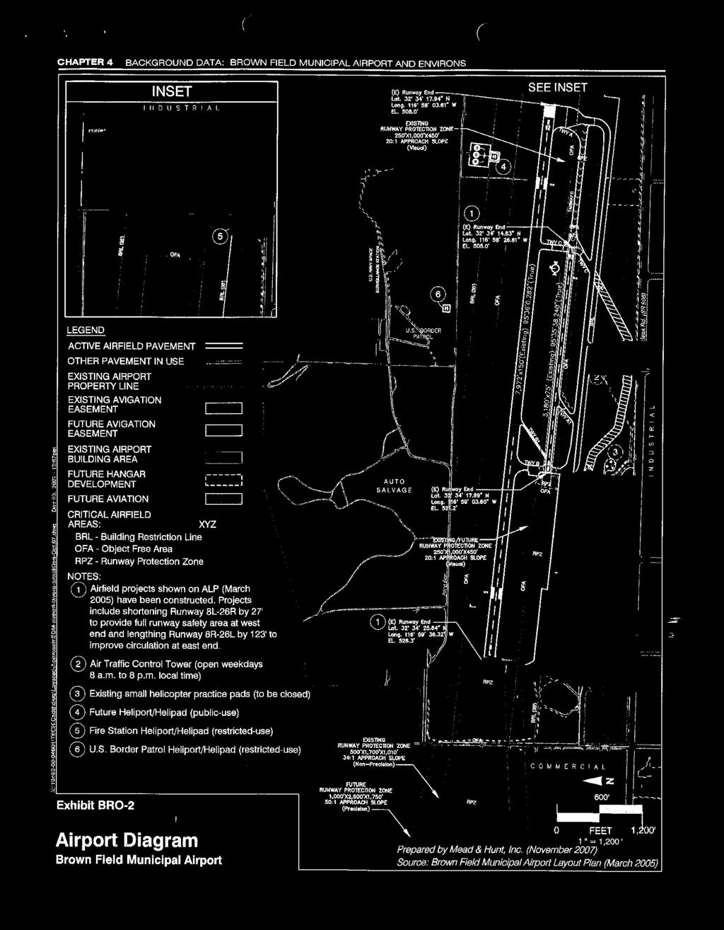
339
340
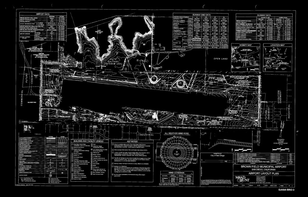
341
342
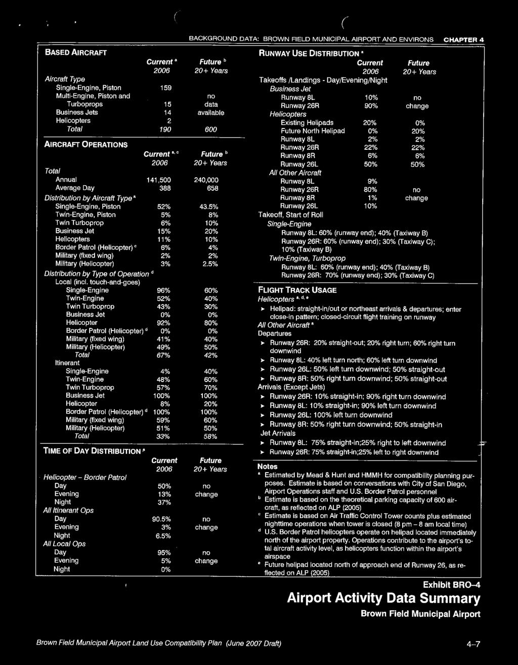
343
344

345
346


347
Beale Air Force Base Land Use Compatibility Plan
 Beale Air Force Base Land Use Compatibility Plan Airport Land Use Commission for Sacramento, Sutter, Yolo, and Yuba Counties Sacramento Area Council of Governments Yuba County, California September 2010
City of Upland, California September 2014 Draft
 Cable Airport Land Use Compatibility Plan City of Upland, California September 2014 Draft Cable Airport Land Use Compatibility Plan September 2014 Draft Prepared for City of Upland, California Prepared
STAFF REPORT. Airport Land Use Consistency Determination Betteravia Plaza. MEETING DATE: January 21, 2016 AGENDA ITEM: 8D
 STAFF REPORT SUBJECT: Airport Land Use Consistency Determination Betteravia Plaza MEETING DATE: AGENDA ITEM: 8D STAFF CONTACT: Andrew Orfila RECOMMENDATION: Adopt findings for the Betteravia Plaza project
Butte County. Airport land use. compatibility plan OROVILLE MUNICIPAL, CHICO MUNICIPAL, RANCHAERO AIRPORTS PARADISE AND
 CHICO MUNICIPAL, OROVILLE MUNICIPAL, PARADISE AND RANCHAERO AIRPORTS Butte County Airport land use compatibility plan Prepared for the BUTTE COUNTY AIRPORT LAND USE COMMISSION Adopted November 15, 2017
APPENDIX K LAND USE. Charles M. Schulz - Sonoma County Airport Draft Environmental Impact Report July 2011 K-1
 APPENDIX K LAND USE Charles M. Schulz - Sonoma County Airport Draft Environmental Impact Report July 2011 K-1 Appendix K Land Use THIS PAGE INTENTIONALLY LEFT BLANK Charles M. Schulz - Sonoma County Airport
STAFF REPORT. Airport Land Use Plan Consistency Review: Old Town Village Mixed Use Project City of Goleta. MEETING DATE: June 18, 2015 AGENDA ITEM: 5M
 STAFF REPORT SUBJECT: Airport Land Use Plan Consistency Review: Old Town Village Mixed Use Project City of Goleta MEETING DATE: AGENDA ITEM: 5M STAFF CONTACT: Peter Imhof, Andrew Orfila RECOMMENDATION:
Chapter 1. Introduction. Placer County Airport Land Use Compatibility Plan
 Chapter 1 Introduction Placer County Airport Land Use Compatibility Plan 1 Introduction OVERVIEW This Placer County Airport Land Use Compatibility Plan (ALUCP) contains the individual Compatibility Plan
Comparison Between Old and New ALUC Plans
 A P P E N I X H Comparison Between Old and New ALUC Plans OVERVIEW This Placer County Airport Land Use Compatibility Plan (ALUCP) sets forth land use compatibility criteria for the environs of Auburn Municipal,
STAFF REPORT. Airport Land Use Plan Consistency Review: Santa Barbara Airport Master Plan. MEETING DATE: November 19, 2015 AGENDA ITEM: 7D
 STAFF REPORT SUBJECT: Airport Land Use Plan Consistency Review: Santa Barbara Airport Master Plan MEETING DATE: AGENDA ITEM: 7D STAFF CONTACT: Peter Imhof, Andrew Orfila RECOMMENDATION: Adopt findings
Notice of Extended Comment Period for an Intent to Adopt a Negative Declaration
 County of Santa Clara Department of Planning and Development Planning Office County Government Center, East Wing, 7 th Floor 70 West Hedding Street San Jose, California 95110-1705 (408) 299-5770 FAX (408)
at: Accessed May 4, 2011.
 3.11 SAFETY 3.11.1 Background and Methodology As with other forms of transportation, there is risk associated with aviation activities. This section focuses on risk to those on the ground near airports.
CHAPTER 6 NOISE EXPOSURE
 CHAPTER 6 NOISE EXPOSURE FAA requires that the NEM submitted for review represent the aircraft noise exposure for the year of submittal (in this case 2008) and for a future year (2013 for OSUA). However,
Chapter Six ALP Drawings. Tacoma Narrows Airport. Master Plan Update
 Chapter Six ALP Drawings Master Plan Update The master planning process for the (Airport) has evolved through efforts in the previous chapters to analyze future aviation demand, establish airside and landside
AIRPORT LAND USE COMPATILIBILTY AIRPORT LAND USE COMPATIBILIITY
 CHAPTER 7 AIRPORT LAND USE COMPATILIBILTY CHAPTER 7 AIRPORT LAND USE COMPATIBILIITY 7.0 INTRODUCTION On airport aviation related development is typically compatible with aircraft operations. On airport
Appendices. Merced County Airport Land Use Compatibility Plan
 Appendices Merced County Airport Land Use Compatibility Plan A P P E N D I X A Foundations of Airport Land Use Compatibility Planning INTRODUCTION This appendix outlines the policy foundations upon which
JOSLIN FIELD, MAGIC VALLEY REGIONAL AIRPORT DECEMBER 2012
 1. Introduction The Federal Aviation Administration (FAA) recommends that airport master plans be updated every 5 years or as necessary to keep them current. The Master Plan for Joslin Field, Magic Valley
MONTEREY REGIONAL AIRPORT MASTER PLAN TOPICAL QUESTIONS FROM THE PLANNING ADVISORY COMMITTEE AND TOPICAL RESPONSES
 MONTEREY REGIONAL AIRPORT MASTER PLAN TOPICAL QUESTIONS FROM THE PLANNING ADVISORY COMMITTEE AND TOPICAL RESPONSES Recurring topics emerged in some of the comments and questions raised by members of the
CHAPTER 1 EXECUTIVE SUMMARY
 CHAPTER 1 EXECUTIVE SUMMARY 1 1 EXECUTIVE SUMMARY INTRODUCTION William R. Fairchild International Airport (CLM) is located approximately three miles west of the city of Port Angeles, Washington. The airport
ORDINANCE NO. _2013-
 ORDINANCE NO. _2013- AN ORDINANCE OF THE TOWNSHIP OF CONEWAGO, DAUPHIN COUNTY, PENNSYLVANIA, PROVIDING FOR AIRPORT ZONING REGULATIONS WITHIN THE AIRPORT ZONING OVERLAY DISTRICT CREATED BY THIS ORDINANCE
AIRPORT NOISE AND CAPACITY ACT OF 1990
 AIRPORT NOISE AND CAPACITY ACT OF 1990 P. 479 AIRPORT NOISE AND CAPACITY ACT OF 1990 SEC. 9301. SHORT TITLE This subtitle may be cited as the Airport Noise and /Capacity Act of 1990. [49 U.S.C. App. 2151
Memorandum. Federal Aviation Administration. Date: June 19, Richard Doucette, Environmental Protection Specialist. From: To:
 Federal Aviation Administration Memorandum Date: June 19, 2008 From: To: Subject: Richard Doucette, Environmental Protection Specialist LaVerne Reid, Airports Division Manager John Donnelly, Regional Counsel
(i) Adopted or adapted airworthiness and environmental standards;
 Adopted or adapted airworthiness and environmental standards;") TECHNICAL ARRANGEMENT FOR THE ACCEPTANCE OF AIRWORTHINESS AND ENVIRONMENTAL APPROVAL OF CIVIL AERONAUTICAL PRODUCTS BETWEEN THE CIVIL AVIATION BUREAU, MINISTRY OF LAND, INFRASTRUCTURE AND TRANSPORT, JAPAN
TECHNICAL ARRANGEMENT FOR THE ACCEPTANCE OF AIRWORTHINESS AND ENVIRONMENTAL APPROVAL OF CIVIL AERONAUTICAL PRODUCTS BETWEEN THE CIVIL AVIATION BUREAU, MINISTRY OF LAND, INFRASTRUCTURE AND TRANSPORT, JAPAN
Finance and Implementation
 5 Finance and Implementation IMPLEMENTATION The previous chapters have presented discussions and plans for development of the airfield, terminal, and building areas at Sonoma County Airport. This chapter
Flying Cloud Airport (FCM) Zoning Process: Informing a Mn/DOT Path Forward
 Zoning Process: Informing a Mn/DOT Path Forward") : Informing a Mn/DOT Path Forward A Review of the Flying Cloud Airport (FCM) Joint Airport Zoning Board (JAZB) Process and the Draft Airport Zoning Ordinance B A RPZ RPZ A B C Zone Chad E. Leqve Director
: Informing a Mn/DOT Path Forward A Review of the Flying Cloud Airport (FCM) Joint Airport Zoning Board (JAZB) Process and the Draft Airport Zoning Ordinance B A RPZ RPZ A B C Zone Chad E. Leqve Director
The following criteria shall be applied within the boundaries of the AO District:
 Sec. 419 (a) Purpose AIRPORT OVERLAY DISTRICT (AO) The purpose of the Airport Overlay District is to regulate and restrict the height of structures, objects, or natural growth, regulate the locations of
Hearings will be held in the Shirley Huffman Auditorium in the Charles D. Cameron Public Services Building, 155 North First Avenue, Hillsboro, Oregon.
 Hearings will be held in the Shirley Huffman Auditorium in the Charles D. Cameron Public Services Building, 155 North First Avenue, Hillsboro, Oregon. On September 24, 2013, the Board of County Commissioners
Appendix C AIRPORT LAYOUT PLANS
 Appendix C AIRPORT LAYOUT PLANS Appendix C AIRPORT LAYOUT PLANS Airport Master Plan Santa Barbara Airport As part of this Airport Master Plan, the Federal Aviation Administration (FAA) requires the development
Executive Summary. MASTER PLAN UPDATE Fort Collins-Loveland Municipal Airport
 Executive Summary MASTER PLAN UPDATE Fort Collins-Loveland Municipal Airport As a general aviation and commercial service airport, Fort Collins- Loveland Municipal Airport serves as an important niche
CHAPTER 1: INTRODUCTION
 CHAPTER 1: INTRODUCTION Purpose and Scope The information presented in this report represents the study findings for the 2016 Ronan Airport Master Plan prepared for the City of Ronan and Lake County, the
CITY OF BELLFLOWER ORDINANCE NO. 1320
 CITY OF BELLFLOWER ORDINANCE NO. 1320 AN ORDINANCE APPROVING ZONING ORDINANCE TEXT AMENDMENT CASE NO. ZOTA 16-04 AMENDING SECTIONS 17.44.235, 17.88.050, AND 17.88.100 OF TITLE 17 OF THE BELLFLOWER MUNICIPAL
Draft Palo Alto Airport Master Plan Report County of Santa Clara, California October 2005
 Draft Palo Alto Airport Master Plan Report County of Santa Clara, California October 2005 County of Santa Clara Board of Supervisors Donald F. Gage Blanca Alvarado Peter A. McHugh James T. Beall, Jr. Liz
Airport Land Use Commission. AIRPORT ENVIRONS LAND USE PLAN for FULLERTON MUNICIPAL AIRPORT
 Airport Land Use Commission AIRPORT ENVIRONS LAND USE PLAN for FULLERTON MUNICIPAL AIRPORT Amended: November 18, 2004 AIRPORT ENVIRONS LAND USE PLAN November 18, 2004 Text of Plan Adopted April 17, 1975
THE BURBANK-GLENDALE-PASADENA AIRPORT AUTHORITY S UPDATE REGARDING ITS NOISE IMPACT AREA REDUCTION PLAN AND ITS PART 161 STUDY SECOND QUARTER 2015
 THE BURBANK-GLENDALE-PASADENA AIRPORT AUTHORITY S UPDATE REGARDING ITS NOISE IMPACT AREA REDUCTION PLAN AND ITS PART 161 STUDY SECOND QUARTER 2015 Pursuant to the California Department of Transportation
Route Support Cork Airport Route Support Scheme ( RSS ) Short-Haul Operations Valid from 1st January Introduction
 Short-Haul Operations Valid from 1st January Introduction") Route Support Cork Airport Route Support Scheme ( RSS ) Short-Haul Operations Valid from 1st January 2016 1. Introduction Cork Airport is committed to encouraging airlines to operate new routes to/from
Route Support Cork Airport Route Support Scheme ( RSS ) Short-Haul Operations Valid from 1st January 2016 1. Introduction Cork Airport is committed to encouraging airlines to operate new routes to/from
Airport Land Use Commission AIRPORT ENVIRONS. LAND USE PLAN for JOHN WAYNE AIRPORT
 Airport Land Use Commission AIRPORT ENVIRONS LAND USE PLAN for JOHN WAYNE AIRPORT Amended: April 17, 2008 AIRPORT ENVIRONS LAND USE PLAN April 17, 2008 Text of Plan Adopted April 17, 1975 Marine Corps
AIRPORTS POLICY 28, AIRPORTS:
 AIRPORTS POLICY 28, AIRPORTS: It is the policy of Washington County to protect the function and economic viability of existing public use airports, while ensuring public safety and compatibility between
LAX Community Noise Roundtable. Aircraft Noise 101. November 12, 2014
 LAX Community Noise Roundtable Aircraft Noise 101 November 12, 2014 Overview Roles and Responsibilities for Aircraft Noise Relevant Federal Regulations Relevant California Regulations Aircraft Noise Metrics
THE BURBANK-GLENDALE-PASADENA AIRPORT AUTHORITY S UPDATE REGARDING ITS NOISE IMPACT AREA REDUCTION PLAN AND ITS PART 161 STUDY SECOND QUARTER 2017
 THE BURBANK-GLENDALE-PASADENA AIRPORT AUTHORITY S UPDATE REGARDING ITS NOISE IMPACT AREA REDUCTION PLAN AND ITS PART 161 STUDY SECOND QUARTER 2017 Pursuant to the California Department of Transportation
AIR TRANSPORTATION ELEMENT
 AIR TRANSPORTATION ELEMENT Sonoma County Permit and Resource Management Department 2550 Ventura Avenue Santa Rosa, CA 95403 Adopted by Resolution No. 08-0808 of the Sonoma County Board of Supervisors September
THE BURBANK-GLENDALE-PASADENA AIRPORT AUTHORITY S UPDATE REGARDING ITS NOISE IMPACT AREA REDUCTION PLAN AND ITS PART 161 STUDY FIRST QUARTER 2015
 THE BURBANK-GLENDALE-PASADENA AIRPORT AUTHORITY S UPDATE REGARDING ITS NOISE IMPACT AREA REDUCTION PLAN AND ITS PART 161 STUDY FIRST QUARTER 2015 Pursuant to the California Department of Transportation
ALASKA AIRLINES AND VIRGIN AMERICA AVIATION SAFETY ACTION PROGRAM (ASAP) FOR FLIGHT ATTENDANTS MEMORANDUM OF UNDERSTANDING
 FOR FLIGHT ATTENDANTS MEMORANDUM OF UNDERSTANDING") ALASKA AIRLINES AND VIRGIN AMERICA AVIATION SAFETY ACTION PROGRAM (ASAP) FOR FLIGHT ATTENDANTS MEMORANDUM OF UNDERSTANDING 1. GENERAL. Alaska Airlines and Virgin America (AS/VX) are Title 14 of the Code
ALASKA AIRLINES AND VIRGIN AMERICA AVIATION SAFETY ACTION PROGRAM (ASAP) FOR FLIGHT ATTENDANTS MEMORANDUM OF UNDERSTANDING 1. GENERAL. Alaska Airlines and Virgin America (AS/VX) are Title 14 of the Code
Short-Haul Operations Route Support Scheme (RSS)
") Short-Haul Operations Route Support Scheme (RSS) Valid from January 1 st, 2018 1: Introduction: The Shannon Airport Authority is committed to encouraging airlines to operate new routes to/from Shannon
Short-Haul Operations Route Support Scheme (RSS) Valid from January 1 st, 2018 1: Introduction: The Shannon Airport Authority is committed to encouraging airlines to operate new routes to/from Shannon
Airport Protection Area
 APPENDIX H Airport Protection Area The Airport Land Use Commission of Alameda County Hayward, California Resolution 93-01 At a meeting held January 13, 1993 Introduced by Commissioner Maestas Seconded
Part 150 and Part 161: Purpose, Elements, and Process
 Part 150 and Part 161: Purpose, Elements, and Process Presentation to: Noise Compatibility Committee January 29, 2015 Ted Baldwin Part 150, Airport Noise Compatibility Planning FAA created in response
Consideration will be given to other methods of compliance which may be presented to the Authority.
 Advisory Circular AC 139-10 Revision 1 Control of Obstacles 27 April 2007 General Civil Aviation Authority advisory circulars (AC) contain information about standards, practices and procedures that the
APPENDIX D FEDERAL AVIATION REGULATIONS, PART 77
 APPENDIX D FEDERAL AVIATION REGULATIONS, PART 77 Subparts A through C PART 77 - OBJECTS AFFECTING NAVIGABLE AIRSPACE Subpart A General 77.1 Scope. 77.2 Definition of terms. 77.3 Standards. 77.5 Kinds of
Notification and Reporting of Aircraft Accidents or Incidents. and Overdue Aircraft, and Preservation of Aircraft Wreckage,
 This document is scheduled to be published in the Federal Register on 12/15/2015 and available online at http://federalregister.gov/a/2015-30758, and on FDsys.gov 7533-01-M NATIONAL TRANSPORTATION SAFETY
Dublin Route Support Scheme ( RSS ) Long-Haul Operations (the Scheme )
 Long-Haul Operations (the Scheme )") Dublin Route Support Scheme ( RSS ) Long-Haul Operations (the Scheme ) 1. Scheme Outline An airline that launches a new route from Dublin Airport (the New Route ), in accordance with the Scheme criteria,
Dublin Route Support Scheme ( RSS ) Long-Haul Operations (the Scheme ) 1. Scheme Outline An airline that launches a new route from Dublin Airport (the New Route ), in accordance with the Scheme criteria,
Ted Stevens Anchorage International Airport
 Ted Stevens Anchorage International Airport 2014 MASTER PLAN UPDATE APPENDIX B - COMMUNICATIONS PLAN JUNE 2014 IN ASSOCIATION WITH: HDR DOWL HKM RIM Architects ATAC CT Argue Aviation Photo credit: Sokol
2. CANCELLATION. AC 39-7B, Airworthiness Directives, dated April 8, 1987, is canceled.
 U.S. Department of Transportation Federal Aviation Administration Advisory Circular Subject: AIRWORTHINESS DIRECTIVES Date: 11/16/95 AC No: 39-7C Initiated by: AFS-340 Change: 1. PURPOSE. This advisory
WELCOME! FORT LAUDERDALE-HOLLYWOOD INTERNATIONAL AIRPORT 14 CFR PART 150 NOISE AND LAND USE COMPATIBILITY STUDY
 WELCOME! FORT LAUDERDALE-HOLLYWOOD INTERNATIONAL AIRPORT 14 CFR PART 150 NOISE AND LAND USE COMPATIBILITY STUDY Public Information Workshop November 2017 1 14 CFR Part 150 Overview Establishes the methodology
TANZANIA CIVIL AVIATION AUTHORITY AIR NAVIGATION SERVICES INSPECTORATE. Title: CONSTRUCTION OF VISUAL AND INSTRUMENT FLIGHT PROCEDURES
 Page 1 of 8 1. PURPOSE 1.1. This Advisory Circular provides guidance to personnel involved in construction of instrument and visual flight procedures for publication in the Aeronautical Information Publication.
Master Plan & Noise Compatibility Study Update
 Working Document-Subject to Change, March 2010 Master Plan & Noise Compatibility Study Update (14 CFR Part 150) TECHNICAL ADVISORY COMMITTEE March 24, 2010 Working Document-Subject to Change, March 2010
Initiated By: AFS-400
 U.S. Department of Transportation Federal Aviation Administration Advisory Circular Subject: Development and Submission of Special Date: 04/14/2015 AC No: 90-112A Instrument Procedures to the FAA Initiated
Appendix C-1 Aviation
 Appendix C-1 Aviation SACOG and Airport Land Use Compatibility Plans AIRPORT LAND USE COMMISSION & COMPATIBILITY PLANS State law defines the purposes of Airport Land Use Commissions as: (1) to protect
Part 150 Noise Compatibility Program Checklist
 Part 150 Noise Compatibility Program Checklist I. IDENTIFICATION AND SUBMISSION OF PROGRAM: Page Number A. Submission is properly identified: 1. 14 C.F.R Part 150 NCP? Yes, Cover, Fly Sheet, Cover Letter
TITLE 16. DEPARTMENT OF TRANSPORTATION CHAPTER 62. AIR SAFETY AND ZONING
 NOTE: This is a courtesy copy of this rule. The official version can be found in the New Jersey Administrative Code. Should there be any discrepancies between this text and the official version, the official
STUDY OVERVIEW MASTER PLAN GOALS AND OBJECTIVES
 INTRODUCTION An Airport Master Plan provides an evalua on of the airport s avia on demand and an overview of the systema c airport development that will best meet those demands. The Master Plan establishes
Airports and UAS: Integrating UAS into Airport Infrastructure and Planning
 ACRP Problem Statement 17-03-09 Recommended Allocation: $500,000 Airports and UAS: Integrating UAS into Airport Infrastructure and Planning ACRP Staff Comments This is one of four UAS-themed problem statements
Draft Concept Alternatives Analysis for the Inaugural Airport Program September 2005
 Section 10 Preferred Inaugural Airport Concept 10.0 Introduction The Preferred Inaugural Airport Concept for SSA was developed by adding the preferred support/ancillary facilities selected in Section 9
Draft Concept Alternatives Analysis for the Inaugural Airport Program September 2005
 Draft Concept Alternatives Analysis for the Inaugural Airport Program September 2005 Section 1 - Introduction This report describes the development and analysis of concept alternatives that would accommodate
Chapter 1 Introduction and Project Overview
 Chapter 1 Introduction and Project Overview Kittitas County in cooperation with the Federal Aviation Administration (FAA) is updating the Airport Master Plan for Bowers Field Airport (FAA airport identifier
Addendum - Airport Development Alternatives (Chapter 6)
") Bowers Field Addendum - Airport Development Alternatives (Chapter 6) This addendum to the Airport Development Alternatives chapter includes the preferred airside development alternative and the preliminary
Bowers Field Addendum - Airport Development Alternatives (Chapter 6) This addendum to the Airport Development Alternatives chapter includes the preferred airside development alternative and the preliminary
Airport Land Use Compatibility Plan (ALUCP) Update. Public Information Meeting #4 June 8 & 9, 2016
 Update. Public Information Meeting #4 June 8 & 9, 2016") Airport Land Use Compatibility Plan (ALUCP) Update Public Information Meeting #4 June 8 & 9, 2016 Agenda 1. Study Process 2. Noise Complaint Patterns 3. Proposed Overflight Areas (AOA) 4. Proposed Land
Airport Land Use Compatibility Plan (ALUCP) Update Public Information Meeting #4 June 8 & 9, 2016 Agenda 1. Study Process 2. Noise Complaint Patterns 3. Proposed Overflight Areas (AOA) 4. Proposed Land
Table of Contents. List of Tables. Cincinnati/Northern Kentucky International Airport 2035 Master Plan Update
 Table of Contents 7.1. Airport Layout Plan (Existing Conditions)... 2 7.2. Airport Layout Plan (Future Conditions)... 3 7.3. Technical Data Sheet... 5 7.4. Commercial Terminal Area Drawing... 5 7.5. East
COMMISSION IMPLEMENTING REGULATION (EU)
") 18.10.2011 Official Journal of the European Union L 271/15 COMMISSION IMPLEMENTING REGULATION (EU) No 1034/2011 of 17 October 2011 on safety oversight in air traffic management and air navigation services
18.10.2011 Official Journal of the European Union L 271/15 COMMISSION IMPLEMENTING REGULATION (EU) No 1034/2011 of 17 October 2011 on safety oversight in air traffic management and air navigation services
Foreign Civil Aviation Authority Certifying Statements. AGENCY: Federal Aviation Administration (FAA), DOT.
, DOT.") This document is scheduled to be published in the Federal Register on 02/22/2019 and available online at https://federalregister.gov/d/2019-02634, and on govinfo.gov [4910-13] DEPARTMENT OF TRANSPORTATION
This document is scheduled to be published in the Federal Register on 02/22/2019 and available online at https://federalregister.gov/d/2019-02634, and on govinfo.gov [4910-13] DEPARTMENT OF TRANSPORTATION
SUMMARY REPORT ON THE SAFETY OVERSIGHT AUDIT FOLLOW-UP OF THE DIRECTORATE GENERAL OF CIVIL AVIATION OF KUWAIT
 ICAO Universal Safety Oversight Audit Programme SUMMARY REPORT ON THE SAFETY OVERSIGHT AUDIT FOLLOW-UP OF THE DIRECTORATE GENERAL OF CIVIL AVIATION OF KUWAIT (Kuwait, 17 to 20 September 2003) International
Welcome to Public Information Workshop 1. San Francisco International Airport FAR Part 150 Study Update Noise Exposure Map Report
 Welcome to Public Information Workshop 1 Chetcuti Room, City of Milbrae 450 Poplar Avenue Milbrae, California 94030 Wednesday, June 4, 2014 5:45 p.m. to 6:45 p.m. PDT The FAA typically uses the airport
NEVADA UAS TEST SITE PRIVACY POLICY
 Introduction NEVADA UAS TEST SITE PRIVACY POLICY As required by the Other Transaction Agreement (OTA) between the Federal Aviation Administration (FAA) and the State of Nevada, DTFACT-14-A-00003, Modification
Asia Pacific Regional Aviation Safety Team
 International Civil Aviation Organization (ICAO) Regional Aviation Safety Group (Asia & Pacific Regions) Asia Pacific Regional Aviation Safety Team GUIDANCE FOR AIR OPERATORS IN ESTABLISHING A FLIGHT SAFETY
DRAFT GENERAL IMPLEMENTATION PLAN AND SPECIFIC IMPLEMENTATION PLAN MIDDLETON MUNICIPAL AIRPORT MOREY FIELD. Revised 12/12/03
 DRAFT GENERAL IMPLEMENTATION PLAN AND SPECIFIC IMPLEMENTATION PLAN MIDDLETON MUNICIPAL AIRPORT MOREY FIELD Revised 12/12/03 As recommended for approval by the Plan Commission General Project Description
EAGLE RIVER UNION AIRPORT HANGAR CONSTRUCTION GUIDELINES Approved 1/29/2008
 EAGLE RIVER UNION AIRPORT HANGAR CONSTRUCTION GUIDELINES Approved 1/29/2008 SECTION 1 - PURPOSE AND SCOPE 1.1 Purpose This document is designed to serve as a guide for private and commercial hangar construction
COMMISSION OF THE EUROPEAN COMMUNITIES. Draft. COMMISSION REGULATION (EU) No /2010
 No /2010") COMMISSION OF THE EUROPEAN COMMUNITIES Brussels, XXX Draft COMMISSION REGULATION (EU) No /2010 of [ ] on safety oversight in air traffic management and air navigation services (Text with EEA relevance)
COMMISSION OF THE EUROPEAN COMMUNITIES Brussels, XXX Draft COMMISSION REGULATION (EU) No /2010 of [ ] on safety oversight in air traffic management and air navigation services (Text with EEA relevance)
Official Journal of the European Union L 186/27
 7.7.2006 Official Journal of the European Union L 186/27 COMMISSION REGULATION (EC) No 1032/2006 of 6 July 2006 laying down requirements for automatic systems for the exchange of flight data for the purpose
Planning Challenges and Solutions
 2007 AirTAP Fall Forum Planning Challenges and Solutions Matt Romanik Past Interim Airport Manager, Grand Rapids Itaska County Airport Gina Mitchell Planner, Bolton & Menk Inc. Kathy Vesely Zoning Coordinator
CHAPTER 61 SHEBOYGAN COUNTY MEMORIAL AIRPORT
 61.01 OPERATION OF AIRPORT 61.02 DEFINITION OF WORDS AND PHRASES 61.03 AIRPORT OPERATION POLICIES 61.04 UTILITIES 61.05 ENTRANCES 61.06 SPECIAL VARIANCE 61.07 ENFORCEMENT 61.08 PENALTY 61.09 MULTIPLE OWNERSHIP
California State University Long Beach Policy on Unmanned Aircraft Systems
 California State University, Long Beach June 14, 2016 Policy Statement: 16-04 California State University Long Beach Policy on Unmanned Aircraft Systems The following policy statement was recommended by
FAA Requirements for Engine-out Procedures and Obstacle Clearance
 FAA Requirements for Engine-out Procedures and Obstacle Clearance Presentation to: CAAC Engine-out Procedures Seminar Name: Chuck Friesenhahn Date: 11/29/2005 Flight Standards Senior Advisor, Advanced
Public Workshop #7 Land Use Planning June 28, 2016
 Public Workshop #7 Land Use Planning June 28, 2016 Land Use Planning and Vision 2040 What is Land Use Planning in the context of the Vision 2040 process? Vision 2040 Aeronautical Development Land Use Compatibility
Harvey Field Airport. Planning Advisory Committee & Public Open House. April 1, Comment Responses
 Harvey Field Airport Planning Advisory Committee & Public Open House April 1, 2015 Comment Responses In an effort to respond to comments received at both the Planning Advisory Committee (PAC) meeting and
AIRPORT ZONING REGULATIONS for the City of McPherson, Kansas
 AIRPORT ZONING REGULATIONS for the City of McPherson, Kansas ARTICLE 1. TITLE, PURPOSE, AUTHORITY AND JURISDICTION 100 Title. These regulations, including the McPherson Airport Zoning Map made a part hereof,
Chapter 10 FAA Compliance Review
 Chapter 10 FAA Compliance Review Introduction This chapter discusses the elements associated with the operation and management of Albany Municipal Airport, as a federally-obligated airport. The Federal
NEGATIVE DECLARATION. NAME OF PROJECT: Fresno County Airport Land Use Compatibility Plan (ALUCP)
") Negative Declaration Fresno County ALUCP December 3, 2018 NEGATIVE DECLARATION The Fresno County Airport Land Use Commission (ALUC) has reviewed the proposed project described below to determine whether
Negative Declaration Fresno County ALUCP December 3, 2018 NEGATIVE DECLARATION The Fresno County Airport Land Use Commission (ALUC) has reviewed the proposed project described below to determine whether
Parkland County Municipal Development Plan Amendment Acheson Industrial Area Structure Plan
 Parkland County Municipal Development Plan Amendment Acheson Industrial Area Structure Plan New Plan Acheson Industrial Area Structure Plan Amendment Parkland County Municipal Development Plan Board Reference
Contents. Page 1 of 11 / Draft Chapter 142 Version CHAPTER AIRPORT ZONING... 2 ARTICLE I. - IN GENERAL... 2
 Contents CHAPTER 142 - AIRPORT ZONING... 2 ARTICLE I. - IN GENERAL... 2 Sec 142-1. - Applicability... 2 Secs. 142-2 142-35. - Reserved.... 3 ARTICLE II. - ST. PETERSBURG-CLEARWATER INTERNATIONAL AIRPORT
Chapter 8.0 Implementation Plan
 Chapter 8.0 Implementation Plan 8.1 Introduction This chapter is the culmination of the analytical work accomplished in the previous chapters. The result is a prioritized list of the essential projects.
RULES OF TENNESSEE DEPARTMENT OF TRANSPORTATION AERONAUTICS DIVISION CHAPTER LICENSING AND REGISTRATION OF AIRPORTS TABLE OF CONTENTS
 RULES OF TENNESSEE DEPARTMENT OF TRANSPORTATION AERONAUTICS DIVISION CHAPTER 1680-1-2 LICENSING AND REGISTRATION OF AIRPORTS TABLE OF CONTENTS 1680-1-2-.01 Purpose 1680-1-2-.06 Repealed 1680-1-2-.02 Definitions
Sample Regulations for Water Aerodromes
 Sample Regulations for Water Aerodromes First Edition (unedited version) March 2015 Notice to users: This document is an unedited version which is made available to the public for convenience. Its content
COMMISSION REGULATION (EU) No 255/2010 of 25 March 2010 laying down common rules on air traffic flow management
 No 255/2010 of 25 March 2010 laying down common rules on air traffic flow management") L 80/10 Official Journal of the European Union 26.3.2010 COMMISSION REGULATION (EU) No 255/2010 of 25 March 2010 laying down common rules on air traffic flow management (Text with EEA relevance) THE EUROPEAN
L 80/10 Official Journal of the European Union 26.3.2010 COMMISSION REGULATION (EU) No 255/2010 of 25 March 2010 laying down common rules on air traffic flow management (Text with EEA relevance) THE EUROPEAN
CHAPTER 3 ALTERNATIVES CONSIDERED
 CHAPTER 3 ALTERNATIVES CONSIDERED 3.0 ALTERNATIVES The 2010 Stevensville Airport Master Plan contained five (5) airside development options designed to meet projected demands. Each of the options from
Airport Master Plan. Rapid City Regional Airport. October 2015 FAA Submittal
 Airport Master Plan Rapid City Regional Airport October 2015 FAA Submittal Rapid City Regional Airport Master Plan Update Table of Contents Executive Summary... i Scope & Timeline... i Forecasts... i Preferred
UNMANNED AIRCRAFT PROVISIONS IN FAA REAUTHORIZATION BILL
 UNMANNED AIRCRAFT PROVISIONS IN FAA REAUTHORIZATION BILL Section 341 Comprehensive Plan -Codifies in title 49 the requirement in the 2012 FAA reauthorization Act that a comprehensive plan to safely accelerate
Background Data: Blue Canyon Airport and Environs
 5 Background Data: and Environs INTRODUCTION serves as an important emergency landing field amid mountainous terrain. The airport has existed on the site since the 1930s or 40s. The facility was operated
Yolo County Airport. ALP Narrative Report. April Prepared by Mead & Hunt, Inc. for the County of Yolo, California
 Yolo County Airport ALP Narrative Report April 2016 Prepared by Mead & Hunt, Inc. for the County of Yolo, California Yolo County Airport ALP Narrative Report Prepared for the County of Yolo Mindi Nunes,
AIRPORT PLANNING, DEVELOPMENT AND LAND ACQUISITION
 30 th Annual AAAE Basics of Airport Law Workshop and 2014 Legal Update October 19-21, 2014 AIRPORT PLANNING, DEVELOPMENT AND LAND ACQUISITION Desk Reference Chapters 4, 13, 14 & 25 Catherine M. van Heuven,
DRAFT MASTER PLAN UPDATE
 DRAFT MASTER PLAN UPDATE CHAPTER VI: AIRPORT LAYOUT PLAN NARRATIVE DRAFT REPORT APRIL 2017 PREPARED BY: Table of Contents WESTCHESTER COUNTY AIRPORT 6 AIRPORT LAYOUT PLAN NARRATIVE REPORT... 6-1 6.1 AGIS
Chapter 4.0 Alternatives Analysis
 Chapter 4.0 Alternatives Analysis Chapter 1 accumulated the baseline of existing airport data, Chapter 2 presented the outlook for the future in terms of operational activity, Chapter 3 defined the facilities
Subtitle B Unmanned Aircraft Systems
 H. R. 658 62 (e) USE OF DESIGNEES. The Administrator may use designees to carry out subsection (a) to the extent practicable in order to minimize the burdens on pilots. (f) REPORT TO CONGRESS. (1) IN GENERAL.
Technical Arrangement on Aircraft Maintenance between the Transport Canada Civil Aviation Directorate and the Civil Aviation Authority of New Zealand
 Technical Arrangement on Aircraft Maintenance between the Transport Canada Civil Aviation Directorate and the Civil Aviation Authority of New Zealand Preamble 1. Transport Canada, Civil Aviation Directorate