Cuerda de Leña Wash Wilderness Proposal PRODUCED BY:
|
|
|
- Myra Walters
- 5 years ago
- Views:
Transcription


1 Cuerda de Leña Wash Wilderness Proposal PRODUCED BY: September 2004
2 Copyright 2004 by Jason A. Williams, Arizona Wilderness Coalition All rights reserved No part of this thesis my be used, reproduced, stored, recorded, or transmitted in any form or manner whatsoever without written permission from the copyright holder or his agent(s), except in the case of use by any individual, educational institution, non-profit organization, or government agency for the purposes of conserving the land. Requests for any other reason should contact: Jason Williams Arizona Wilderness Coalition PO Box 2741 Prescott, AZ Or Don Hoffman Arizona Wilderness Coalition PO Box 529 Alpine, AZ Many thanks go to Prescott College students Scott Koch and Cacia McClain for their efforts in field inventory, GIS work, sensitive species research, and document production and editing. The Arizona Wilderness Coalition is an organization of groups and individuals working to protect and restore wilderness and other wildlands and waters in Arizona. For more information please visit our website or contact us through the information provided above

3 Cuerda de Leña Wash Unit Description Cuerda de Leña Wash is exactly that, a broad, sandy plain characterized by several washes. It is part of the Valley of the Ajo and has little topographic relief. It is located 4 miles south of Ajo, Arizona in Pima County directly east of Bates Well Road. There is a small chain of hills in the northern portion of the unit that rise about 200 feet above the surrounding valley. These hills provide diverse vegetation, such as creosote, and palo verde stands. Although small, these hills have a character of their own and create a mysterious and beautiful landscape. The palo verde stands also create a diverse microhabitat for an array of flora and fauna. Cuerda de Leña Wash also supports dense thickets of ironwood and mesquite. These thickets provide more cover and protection for flora and fauna species inhabiting the area. The creosote-bursage flats outside of the wash are critical habitat to the endangered Sonoran pronghorn and numerous unique reptile species. 1
4 Arizona Wilderness Coalition Arizona Wilderness Coalition 2

5 Size: 11,578 acres Wilderness Characteristics Naturalness The Cuerda de Leña Wash proposed wilderness generally appears to have been affected primarily by the forces of nature, with the imprint of man s work substantially unnoticeable as outlined in The Wilderness Act of The photographic documentation included within this report shows the natural condition from various vantage points within and outside the proposed unit. In past BLM inventories the natural character of the Cuerda de Leña Wash unit has been stated as, clearly and obviously not meeting wilderness criteria (USDI 1979). The initial BLM study unit was 10,460 acres. In recent citizen s inventories View to the north from inside the Cuerda de Leña Wash unit conducted by the Arizona Wilderness Coalition in 2003 some of the recreational ORV imprints have been reclaimed by the natural condition of the area. See photos: CL-1-8; CL-1-18; Cl The routes/roads that at one time led to the noticeable impacts are now substantially re-vegetated. 3
6 Outstanding Opportunities for Solitude or Primitive and Unconfined Recreation The Cuerda de Leña Wash proposed wilderness possesses both opportunities for solitude and primitive and unconfined recreation. The opportunities for both exist within most of the unit. The BLM s Wilderness Inventory and Study Procedures Handbook H section (b)(1) gives direction on the assessment of solitude in inventory units. In this section five features for evaluating solitude are given. a. Size and configuration: The unit meets the 5,000-acre size criteria, and it is not long and narrow and does not have irregular extensions or cherrystems. b. Topographic screening: Cuerda de Leña Wash and the other washes feeding into it provide an outstanding sense of solitude because they are deeply incised in many places. The gently rolling creosote flats surrounding the washes are deceiving to the visitor because one can easily lose sight of a vehicle by walking a couple hundred yards. There are also some rugged hills in the northern portion of this unit where the topography provides outstanding isolation and solitude from other visitors. c. Vegetative screening: On the hillsides just below the rugged hills the vegetative screening is exceptional with a diversity of vegetation ranging from stands of saguaro and palo verde to wide expanses of creosote. Near the washes the vegetative screening increases to stands of mesquite, ironwood, and palo verde and provides complete screening and outstanding opportunities for solitude from other visitors. Some places in the washes are extremely dense with vegetation, requiring the visitor to crawl to get through. d. Ability of user to find a secluded spot: seclusion in the many washes is not difficult as the vegetation is lush and dense. There are also basins and hilltops that provide outstanding opportunities for solitude because of their jagged and diverse topography. 4
7 e. Presence of outside sights and sounds: There are no outside sights or sounds that impact the opportunities for solitude or unconfined primitive recreation in this unit. Primitive and Unconfined Recreation The Cuerda de Leña Wash unit allows a variety of primitive and unconfined recreational activities. Cuerda de Leña Wash offers various levels of hiking, from flat walking in the washes and bajadas, to rock scrambling on the nearby hills and ridges. Backpacking, hunting, horseback riding, photography, bird watching, and sightseeing for geological, zoological, and especially botanical features are all possible primitive and unconfined recreational opportunities within the Cuerda de Leña Wash proposed wilderness. The uniqueness of this unit is increased by its flatness and the excellent spring wildflowers that can be viewed here. Supplemental Values and New Information Various supplemental values as described in section 2(c) of The Wilderness Act exist in the Cuerda de Leña Wash unit. The Arizona Wilderness Coalition believes that wilderness preservation is not only important for human needs, View to the south of Kino peak in Organ Pipe NM but for the conservation of species as well. The following section represents detailed information about the supplemental wilderness values of Special Status species in the proposed Cuerda de Leña Wash wilderness. All species described here are at risk and would be more adequately protected with wilderness designation. 5
8 cactus ferruginous pygmy owl Glaucidium brasillanum cactorum The cactus ferruginous pygmy owl is federally listed as endangered and is Species of Special Concern in Arizona. It is a species whose occurrence in Arizona is or may be in jeopardy, or with known or perceived threats or population declines, as described by the Arizona Game and Fish Department's listing of Wildlife of Special Concern in Arizona. The pygmy-owl has been found in palo verde cacti-mixed scrub associations of the Sonoran Desert, much like the vegetative community in Cuerda de Leña Wash. In central and southern Arizona, the pygmy-owl is currently found primarily in Sonoran Desert scrub vegetation with some locations in riparian drainages and semi-desert grassland vegetation communities. The cactus ferruginous pygmy-owl nests in cavities, primarily in saguaro cacti, but they will also use tree cavities if available. The presence of saguaro and multiple tree species is abundant in the unit providing habitat for many of these individuals. Pygmy-owls are found below 4,000 feet in elevation and the subspecies, G. b. cactorum, is geographically isolated into eastern and western populations. The western population extends from lowland central Arizona south through western Mexico. The pygmy owl is threatened by the destruction, modification, and curtailment of its habitat and range due to ORV use and other developmental impacts, possible competition with introduced bird species for food and nest sites, and potentially inbreeding due to increasingly fragmented and small isolated populations within the state. Because of these threats, is it crucial to the survival of this subspecies that the available habitat for this species in Cuerda de Leña Wash be protected as wilderness. Sonoran pronghorn Antilocapra americana sonoriensis The Sonoran pronghorn is federally listed as endangered and is wildlife of special concern in Arizona according to the AZGF HDMS listing. This species is a historic inhabitant of southwest Arizona. They require a variety of habitats for forage and migration. Some of these habitats include open creosote-bursage areas, allowing for expansive views to locate and escape predators. The Sonoran pronghorn populations are quickly decreasing due to habitat fragmentation and loss. Protection of any population in 6
9 the state is crucial to their survival. Habitat protection is the only way this species will not be extirpated from Arizona. The Cuerda de Leña Wash unit provides some of the best forage and fawning habitat for Sonoran pronghorn. Ajo mountain copper leaf Acalypha pringlei Although this species is not federally listed, the AZGF manages for its survival and protection. Conflicting Resource Issues 1. Minerals there are no active mines within the Cuerda de Leña Wash proposed Wilderness. 2. Off Road Vehicle use Many of the existing wildcat routes have been created by irresponsible Off Road Vehicle-users. Destruction of vegetative, geological, and scenic qualities of the Cuerda de Leña Wash unit occurs mostly around highly impacted Off Road Vehicle routes (see photos: CL-1-14, 15, 16). The occurrence of torn-up vegetation and erosion leading to topsoil loss from Off Road Vehicle use is highly destructive to this fragile desert ecosystem. Such actions are not appropriate anywhere. Off Road Vehicle use in this area is the number one impact to resource values such as Sonoran pronghorn and pygmy owl habitat. The evidence is so clear that it would not take a study to determine that the problem is the proliferation of illegal wildcat routes used for the sole purpose of recreational Off Road Vehicles. These uses are incompatible with the preservation and protection of the values of the study unit and therefore do not pose a valid resource conflict other than that they are rapidly destroying the wilderness character of the Cuerda de Leña Wash unit. 7
 of 1976. The BLM started an initial inventory of all public lands under their management in Arizona and sorted out all lands that clearly and obviously lacked wilderness characteristics.")
10 Historical Review: The Arizona BLM Wilderness Inventory ( ) The BLM s initial wilderness inventory was completed under the requirements of section 603 of the Federal Lands Policy and Management Act (FLPMA) of The BLM started an initial inventory of all public lands under their management in Arizona and sorted out all lands that clearly and obviously lacked wilderness characteristics. Through this process the Cuerda de Leña Wash (unit # 2-182) was chosen as an initial inventory area. In the Initial Inventory process started in 1978 the BLM reported in their, Wilderness Review, Arizona Initial Inventory of Public Lands Administered by Bureau of Land Management Decision Ajo lily Report September 1979, that "a few comments were received suggesting that the unit contain various outstanding wilderness characteristics and that the area be intensively inventoried" (USDI 1979). In the Wilderness Review, Arizona Initial Inventory of Public Lands Administered by BLM Proposal Report 1979, the BLM recommended the Cuerda de Leña Wash should not undergo further inventory (USDI 1979). The BLM proposed in this report that, This unit was originally proposed as clearly and obviously not meeting wilderness criteria. The rational behind this proposal was not questioned. We conclude that this unit will not be intensively inventoried, and is therefore dropped from further review. (USDI 1979) In this initial inventory, the BLM s explanation for dropping the unit from further study is unexplained and unspecific. The documentation of the comments received did not adequately describe the reasoning or the specific wilderness criteria that were not met. 8

11 The Arizona Wilderness Coalition has reviewed the historical material for the Cuerda de Leña Wash inventory unit and finds that the BLM s reasons for dropping this unit are severely lacking and inconsistent with the BLM s own recommendations. Desert wildflowers near Cuerda de Leña Wash The following information is part of the New Information criterion as explained in the BLM H handbook Section.06 (E)(b) and a detailed explanation of why past inventories are lacking. 1.) The BLM H handbook explains the direction given by the Wilderness Act in reference to outstanding opportunities for solitude or primitive and unconfined type of recreation. The word or in this sentence means that a proposed wilderness does not have to possess outstanding opportunities for both solitude and primitive recreation; it only has to possess one or the other. (USDI 2001 [H , Section.22(A)(1)(b), page 21]). The Initial Inventory made no reference to the possibilities for solitude or unconfined primitive recreation and excluded this from their explanation of dropping the unit from further study. 2.) There was no reference made to any wilderness precluding characteristics within the unit. Therefore, it is unknown whether or not the unit possesses these many characteristics other than those allowing for opportunities for solitude or primitive and unconfined recreation and the unit must be re-inventoried. 3.) The BLM did not address the Supplemental Values of this study unit. The BLM is instructed to determine if the inventory unit contains ecological, geological, or other features of scientific, educational, 9
12 scenic, or historical value (USDI 2001 [H , Section.13(4)(a). In conjunction with this instruction, the Wilderness Act states that the unit may also contain these supplemental values. The values in the Cuerda de Leña Wash unit primarily consist of species of special concern. The BLM did not take these federally listed species in its initial inventory. It is mandated in the Endangered Species Act that the habitat for these species be protected. The unit needs to be reevaluated for this reason as well as those listed in previous examples. 4.) The BLM handbook gives direction on evaluating solitude by explaining that consideration should be given to factors which influence a person's opportunity to avoid the sights, sounds, and evidence of other people within the inventory unit, and not opportunities for solitude in comparison to human habitation (USDI 2001 [H , Section 13(B)(3)(c)(1)(a), page 14]). The BLM states that "[t]he fact that nonwilderness activities or uses can be seen or heard from areas within the inventory area shall not be considered when analyzing an area's manageability as a WSA" (USDI 2001 [H , Section.2(B)(4), page 24]). The agency instructs its staff to: a. Avoid using lack of terrain variation or vegetation or size as disqualifying conditions for outstanding opportunities for solitude (USDI 2001 [H , Section.13(B)(3)(c)(2)]). Because it was not stated in the BLM s Initial Inventory, it must be assumed that because of the lack of topographic relief, the only characteristic stated in the Initial Inventory, the unit was dropped (USDI 1979). The BLM stated in the unit description that, the area has very little topographic relief other than a chain of hills in the northwest corner of the unit. The BLM cannot drop a unit from further study because the unit lacks one wilderness characteristic. It is the combination of these characteristics that creates a wilderness environment. b. Do not assume that simply because an area or portion of an area is flat and/or unvegetated, it automatically lacks an outstanding opportunity for 10
13 solitude (USDI 2001 [H , Section 13(B)(3)(c)(1)(b), page 14]). It seems that in their Initial Inventory, the BLM certainly did assume that because Cuerda de Leña Wash is mostly flat that it lacked in outstanding opportunity for solitude. c. Consideration must be given to the interrelationship between size, screening, configuration, and other factors that influence solitude (USDI 2001 [H , Section.13(B)(3)(c)(1)(b), page 14]). The BLM did not mention any of these factors in their explanation for dropping the unit. d. Consider factors or elements influencing solitude including size, natural screening, and the ability of the user to find a secluded spot (USDI 2001 [H , Section.13(B)(3)(c)(1)(c)], page 15). Again, the BLM did not consider these factors in the Initial Inventory. The historical review of the initial inventory process for the Cuerda de Leña Wash unit clearly shows that the BLM must reconsider this unit for an intensive inventory. This review provides a piece of the, New Information criterion as explained in the BLM H handbook Section.06 (E)(b). The BLM must consider many aspects of new information, including but not limited to: population expansion, Threatened and Endangered species, and changing recreational uses. In conclusion, the BLM must reconsider wilderness for the Cuerda de Leña Wash unit to evaluate the flaws that occurred in past inventories, as well as for the purposes of protecting valuable wildlands. Conclusion The Cuerda de Leña Wash unit meets all the requirements for Wilderness Study Area designation. The documentation provided here and in the general justifications section of this report supply the required new and supplemental information to make this proposal a valid recommendation in the planning process. The results of non-designation have already been seen in this area with the proliferation of new wildcat routes created by uncontrolled Off Road Vehicle users. The best management decision for this isolated and unique area is wilderness protection. 11
14 12
15 13


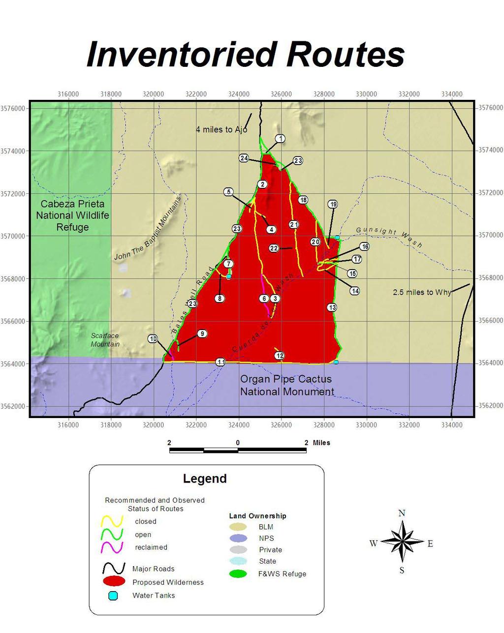
16 Route Analysis and Photographic Documentation for the Cuerda de Len a Wash Unit Route #: 1 Photos: BM-1-21; BM-1-24; CL-1-1 Length:.27 miles Construction Type: Bladed long ago Campsites: 2 Vehicle Type: HC 4WD Erosion: 12 + Vegetation Present: bare soil > 50% of surface Other Impacts: Some one time cross country travel tracks Proposed Action: Open Notes: This is the northern boundary route for the Cuerda de Len a Wash unit. This route will remain open under this wilderness proposal and should be included in dispersed camping management plans in this area. BM-1-24: Average conditions on route 1, has erosion in wash crossing over 12 inches. Direction: SW BM-1-21: Junction with route 1 on east side Direction: SW Route #: 2 Photos: CL-1-2 Length:.34miles Construction Type: user created Campsites: 1 Vehicle Type: 2WD Erosion: ORV damage from numerous one-time cross-country travel tracks Vegetation Present: bare soil > 50% of surface Other Impacts: Trash from camping and target shooting Proposed Action: Open Notes: This route is on the original Quadrangle. The impacts and use make cherry stemming a good option for this route. This campsite should also be managed for dispersed camping. CL-1-1: Junction with Route 1 on west side Direction: E 14


17 CL-1-2: Campsite at end of route 2. Trash in picture. Direction: SE CL-1-3: Junction with route 5. Direction: S Route #: 3 Photos: CL-1-3; CL-1-4; CL-1-6 thru CL-1-11 Length: 3.75 miles Construction Type: user created Campsites: 0 Vehicle Type: 4WD Erosion: photo CL-1-7 shows 8 of soil loss. ORV and vehicular damage from numerous one time cross country travel tracks Vegetation Present: bare soil > 50% of surface with creosote growing in route until entering wash where vegetation growth increases dramatically and crowds route. Other Impacts: Trash: bicycle in photo CL-1-6, packed out. Proposed Action: Close Notes: This route is on the original Quadrangle. It receives no apparent use and has no grazing, mining, or camping related evidence/facilities. The use that has occurred has pushed this route further into Cuerda de Len a wash, where it fades and forks into numerous faint tracks making the route very difficult to follow. Users become confused and begin to travel cross-country to find the route creating an even more confusing web of cross-country vehicle tracks. Cuerda de Len a wash is the best xeri-riparian habitat for miles around and should be protected at all costs. This route also occurs in critical habitat for the endangered Sonoran Pronghorn, which are extremely sensitive to human disturbances. Closure of this route would protect not only the ecological wilderness characteristics, but opportunities for solitude as well. CL-1-4: Junction Route 4 Direction: S CL-1-6: Average conditions on route 3. abandoned bicycle trash (packed out). Direction: S 15


18 CL-1-7: Worst erosion, 8 deep. Direction: S CL-1-8: Average conditions on route 3, overgrown. Direction: N CL-1-10: End of route 3, disappears just past this point. Direction: S Route #: 4 Photos: CL-1-4; CL-1-5; and scenic/naturalness photos included in proposal text Length:.36 miles Construction Type: user created Campsites: 1 Vehicle Type: HC 4WD Erosion: stable Vegetation Present: bare soil > 50% of surface with creosote over 1 ½ ft tall in middle of route. Other Impacts: numerous one-time ORV crosscountry travel tracks leaving lasting impressions in desert pavement Proposed Action: close Notes: This is a route that begins to fade and starts to spider web as users get confused. This route sprawl will continue to intensify as this route is very difficult to follow because it has been created by users following cross country travel tracks. The beautiful desert pavement in this are is being degraded for years to come form this confusing route. Wilderness values outweigh the recreational value of these illegal routes. CL-1-9: Woodcutting on Route 3 16


19 CL-1-5: Average conditions on Route 4. Direction: W Route #: 5 Photos: CL-1-3; CL-1-12 thru CL-1-18 Length:.46 miles Construction Type: user created Campsites: 1 Vehicle Type: 2WD Erosion: ORV damage Vegetation Present: bare soil > 50% of surface with creosote over 3 ft tall in middle of route in some places. Other Impacts: Campsite trash, target shooting, and numerous one time ORV cross country travel tracks, as well as numerous donuts and parallel routes leaving lasting impressions. Proposed Action: close Notes: The route should be closed past the one heavily impacted campsite. The route has been severely impacted from ORV abuses. Pictures show three parallel routes in one-area as well as vehicle donuts. An OHV sign has been posted here, but no effort to close the area from further damage. This is a prime example of uncontrolled and irresponsible ORV us that has impacted this fragile desert system for decades to come. The actual route does fade out, but the initial tracks and impacts will require restoration. The proposed wilderness boundary has been adjusted to exclude the campsite, but it includes the heavily impacted ORV area to assist in easier management of the wilderness boundary and to take advantage of the restoration values of wilderness. CL-1-12: Large trashed campsite on route 5. Direction: SE CL-1-13: Part of route 5, reclaimed. Direction: SW OHV sign just past photo CL


20 CL-1-14: ORV destruction on route 5. Direction: N/A CL-1-17: Three parallel routes on route 5. Direction: NE CL-1-15: ORV Destruction on route 5. Direction: N/A CL-1-16: More ORV donuts on route 5. Direction: NE CL-1-18: Re-vegetation on route 5, no use evident. Direction: S Route #: 6 Photos: CL-1-11 Length: 1.28 miles Construction Type: user created Campsites: 0 Vehicle Type: N/A Erosion: stable Vegetation Present: bare soil > 50% of surface with creosote over 3 ½ ft tall in middle of route. Other Impacts: Proposed Action: close Notes: The route could not be found at its southern terminus shown on the map. At Photo point CL-1-11 it is well reclaimed with large creosote. No vehicle tracks or evidence of recent use is visible. The closure of this route would further enhance the wilderness characteristics as described in the evaluation of its connecter route #3. 18


21 CL-1-11: Evidence of nonuse on route #6. Direction: S CL-1-20: End route 7 at stock tank. Direction: N Route #: 7 Photos: CL-1-19; CL-1-20; CL-1-21 Length:.95 miles Construction Type: Bladed FLPMA Road Definition: Yes Campsites: 0 Vehicle Type: HC 2WD Erosion: stable Vegetation Present: bare soil > 50% of surface Other Impacts: Proposed Action: open Notes: This route accesses a stock tank that was full when I was there. There were ducks in the tank. I encountered to older couples here enjoying the spring day. The area of course is in very poor shape from livestock staying close to the tank. This route and the area will be cherry stemmed to prevent any conflicts with wilderness. Cl-1-19: Beginning route 7. Direction: SW 19 Cl-1-21: End route 7 at stock tank and corral Direction: S Route #: 8 Photos: CL-1-22; CL-1-23; CL-1-24 Length:.45 miles Construction Type: user created Campsites: 0 Vehicle Type: HC 4WD Erosion: photo CL-1-23 Vegetation Present: bare soil > 50% of surface Other Impacts: Proposed Action: close Notes: This is a redundant unnecessary route to the stock tank that was user created. It is experiencing erosion and vegetation growth on route. ORV tracks were present.


22 CL-1-22: Junction route 8. Direction: W Route #: 9 Photos: CL-1-25; CL-1-26; CL-1-27; CL-1-28 Length:.35 miles Construction Type: user created Campsites: 3 Vehicle Type: 2WD Erosion: ORV damage Vegetation Present: bare soil < 50% of Other Impacts: Live woodcutting, trash, and target shooting Proposed Action: open Notes: This route has numerous campsites along a wash with shade trees. It is well used, and was in use when I was there. It provides excellent camping opportunities before entering Organ Pipe Cactus National Monument. This area should be managed for dispersed camping and for keeping vehicles out of the wash as well as from pushing the route further into the potential wilderness unit. It will be cherry stemmed to prevent conflicts with wilderness. CL-1-23: Average conditions on route 8 Direction: E CL-1-25: Junction of route 9 and Bates Well Road Direction: SE CL-1-24: Junction of route 8 and Bates Well Road Direction: S CL-1-26: Campsite and trash on route 9. Direction: W 20


23 CL-1-27: End route 9, campsite in use. Direction: SW Cl-1-29: Route 10, reclaimed. Direction: S CL-1-28: Off road travel on route 9 Direction: E Route #: 10 Photos: CL-1-29 Length:.4 miles on map Construction Type: reclaimed Campsites: 0 Vehicle Type: N/A Erosion: stable Vegetation Present: bare soil <50% of surface with creosote over 3 ½ ft tall in middle of route with grass. Other Impacts: N/A Proposed Action: close Notes: The route could not be found at its southern terminus shown on the map. A well reclaimed route that should be taken off of maps. Closure of this route will assist in protecting wilderness characteristics. 21 Route #: 11 Photos: CL-1-30 thru CL-1-41; CL-1-45 Length: 5.1 miles Construction Type: user created Campsites: 1 Vehicle Type: HC 4WD Erosion: 4 feet of soil lose exiting Cuerda de Len a wash CL-1-41 Vegetation Present: bare soil <50% of surface Other Impacts: Undocumented Immigrant trash is evident along this route, but not excessive. Some ORV use is occurring. Proposed Action: close Notes: Close this route to prevent more user created routes being created off of it. It is redundant. Organ Pipe NM has an administrative road that parallels on the other side of the fence that could be used by border patrol if necessary. This entire route borders Organ Pipe National Monument wilderness. Overall, this route receives very little use because it can only be used by well-equipped 4WD vehicles. A roost for at least five Great horned owls exists where this route crosses Cuerda de Len a wash. I also observed Kestrels, Red tailed hawks, and numerous other bird species and mammal tracks using this wash. Closure would further protect ecological wilderness characteristics. The parallel fence between the BLM and NPS lands in this area has low strung barbed wire for its bottom strand, which will inhibit endangered Sonoran pronghorn movement through this area. They do not jump fences, they go under. If they do move through here they will develop sores on their backs from squeezing under the barbed wire fences.


24 CL-1-30: Junction with Organ Pipe Cactus NM Direction: S CL-1-33: Average conditions on route 11. Direction: W CL-1-31: Begin route 11 Direction: E CL-1-34: Average conditions on route 11. Direction: E CL-1-32: Old drill hole on route 11 no use evident Direction: NW CL-1-40: Worst erosion on route 11 braided Direction: NE 22


25 CL-1-41: Worst erosion on route 11 exiting wash Direction: E CL-1-42: Junction with route 12 Direction: W Cl-1-45: Corral and tank at junction of routes 11 and 12, excluded from proposed wilderness. Direction: E Cl-1-43: End route 12. Direction: W Route #: 12 Photos: CL-1-42; CL-1-43; CL-1-44 Length:.5 miles Construction Type: user created Campsites: 0 Vehicle Type: 4WD Erosion: N/A Vegetation Present: primarily grass <25% bare soil Other Impacts: N/A Proposed Action: close Notes: This route looks as if it has seen 5-10 uses ever. It may have been created by UDIs. I found some empty water bottles at its end. It looks like a monkey see monkey do route. People think this is the route that goes north and it fades out leaving users looking for the rest of it driving in circles. The route serves no purpose. Closure would further protect wilderness characteristics in the area. 23 CL-1-44: Average conditions on route 12. Direction: NE


; Cl-1-50; CL-1-51 Length:.")

26 Route #: 13 Photos: CL-1-45 (see above); CL-1-46; CL-1-55 Length: 3.6 miles Construction Type: May have been bladed at one time, but no evidence exists currently. Campsites: 1+ Vehicle Type: 4WD Erosion: N/A Vegetation Present: bare soil > 50% of surface with some overgrown spots. Other Impacts: Some one time cross country travel impacts Proposed Action: open Notes: This route connects stock improvements and is used for some recreational access. Forms the eastern boundary of the Cuerda de Len a Wash unit. Route #: 14 Photos: CL-1-46 (see route 13); Cl-1-50; CL-1-51 Length:.93 miles Construction Type: User created Campsites: 0 Vehicle Type: 4WD Erosion: N/A Vegetation Present: bare soil > 50% of surface Other Impacts: Some one time cross country travel impacts Proposed Action: Close Notes: This route was user created to access a gate that only allows foot or equestrian traffic. It is unnecessary, as it does not provide additional access to any thing specific. CL-1-46: Junction of routes 13 and 14. Direction: W CL-1-50 Walk through gate on route 14. Direction: S CL-1-55: junction routes 16 and 13 Direction: S CL-1-51: Average conditions on route 14 Direction: W 24


27 Route #: 15 Photos: CL-1-47; Cl-1-48; CL-1-49 Length:.5 miles Construction Type: User created Campsites: 1 Vehicle Type: 4WD Erosion: N/A Vegetation Present: bare soil > 50% of surface Other Impacts: Some one time cross-country travel impacts and ORV use into the wash at the end of the route. Proposed Action: open Notes: This route was user created to access a cluster of range fence that comes together in this area. It is redundant with routes 16 and 17, but has campsites so it should be the one left open if any. CL-1-47: End route 15 campsite. Direction: W CL-1-49: Route 15 junction with 13 and 17 Direction: N Route #: 16 Photos: CL-1-54; Cl-1-55 (see route 13 photos) Length:.57 miles Construction Type: User created Campsites: 0 Vehicle Type: 4WD Erosion: N/A Vegetation Present: bare soil > 50% of surface Other Impacts: Proposed Action: Close Notes: This route was user created to access the same cluster of range fence in this area. It had access to the wash at one time and is now overgrown. It is redundant and should be closed. Route #15 provides adequate access. CL-1-48: Average conditions on route 15 Direction: SW 25 CL-1-54: End route 16 at wash, overgrown. Direction: W


28 Route #: 17 Photos: CL-1-49 (see route 15 photos) Length:.45 miles Construction Type: User created Campsites: 0 Vehicle Type: 4WD Erosion: N/A Vegetation Present: bare soil > 50% of surface Other Impacts: Proposed Action: Close Notes: This route was user created and follows a range fence its whole length to access the same cluster of range fence in this area. It is redundant and should be closed. Route #15 provides adequate access. Route #: 18 Photos: CL-1-57; Cl-1-59; CL-1-62; CL-1-68; CL-1-69 Length: 4 miles Construction Type: Bladed and maintained FLPMA Road Definition: Yes Campsites: Numerous Vehicle Type: 2WD Erosion: N/A Vegetation Present: bare soil > 50% of surface Other Impacts: Trash, one time cross-country tracks and ORV track proliferation Proposed Action: open Notes: This route forms the Northeast boundary for the Cuerda de Len a Wash unit, and the Southeast boundary for the Black Mountain unit. It is in good condition and is used regularly by recreationalists and ranchers. CL-1-59: Junction of routes 18 and 20. Direction: S CL-1-62: Junction of routes 18 and 21. Direction: SE CL-1-68: White spot in center of photo is people camping at end of route 23. Direction: SW CL-1-57: Junction of routes 18 and 19, average conditions. Direction: S 26


; CL-1-60; CL-1-61 Length: 1.")

29 CL-1-69: Entrance to camping area at junction with routes 18 and 24. Direction: S Route #: 19 Photos: Cl-1-57 (see route 18 photos); CL-1-58 Length:.4 miles Construction Type: May have been bladed at one time, but not maintained. FLPMA Road Definition: No Campsites: 0 Vehicle Type: HC 2WD Erosion: N/A Vegetation Present: bare soil > 50% of surface Other Impacts: Proposed Action: Close to public use Notes: This route provides access to an AZ Game and Fish Guzzler/Water catchment. The route should be closed to public use and open to administrative use with a minimum tool/data requirements study as outlined in BLM s manual H appendix D and page 43. Route #: 20 Photos: CL-1-59 (see route 18 photos); CL-1-60; CL-1-61 Length: 1.22 miles Construction Type: User Created FLPMA Road Definition: No Campsites: 0 Vehicle Type: HC 4WD Erosion: N/A Vegetation Present: bare soil is between 25-50% of surface Other Impacts: N/A Proposed Action: Close Notes: This route was most likely created by the rancher for maintenance of the fence line that it runs along. It probably used to hook up with route #15 and 16, but is now overgrown. It should be closed as route #15 provides adequate access to the area for maintenance and roads are not necessary for fence line maintenance. CL-1-60: End route 20 Direction: SE CL-1-58: Guzzler at end of route 19. CL-1-61: Average conditions along fence line. Direction: N 27


30 Route #: 21 Photos: CL-1-62 (see route 18 photos); CL-1-63; CL-1-64 Length: 2.8 miles Construction Type: User Created FLPMA Road Definition: No Campsites: 0 Vehicle Type: HC 2WD Erosion: N/A Vegetation Present: bare soil is >50% of surface/desert pavement Other Impacts: N/A Proposed Action: Close Notes: This route does not appear to have any purpose. It follows the high ground on desert pavement through a section of state land and on into the Cuerda de Len a Wash unit where it fades away and ORV tracks continue. Since this route appears to have no purpose it should be closed to protect wilderness values. This will help protect the wash area from ORV abuse. Route #: 22 Photos: CL-1-65; CL-1-66 Length: less than 1/10 of a mile Construction Type: User Created FLPMA Road Definition: No Campsites: 0 Vehicle Type: HC 2WD Erosion: N/A Vegetation Present: Mostly Desert Pavement Other Impacts: N/A Proposed Action: Close Notes: This is a very small route off of route 21. CL-1-65: Junction Routes 21 and 22. Direction: SW CL-1-63: End route 21 Direction: S CL-1-64: Average conditions as route 21 fades. Direction: S CL-1-66: Average conditions on 22 route fades after 150 ft. Direction: S 28


; CL-1-70; CL-1-71 Length:.")
31 Route #: 23 Photos: CL-1-67; CL-1-68 Length:.18 miles Construction Type: old prospect road FLPMA Road Definition: No Campsites: 1+ Vehicle Type: HC 2WD Erosion: N/A Vegetation Present: bare soil is >50% of surface Other Impacts: N/A Proposed Action: Open Notes: This route has large campsite at its end. This one should be managed for primitive dispersed camping along with the other campsites in the northern part of this unit. removed. The tracks shown in CL-1-71 must not be allowed to proliferate, as this area will provide excellent opportunities for users to camp and access the wilderness. Aggressive signing will be necessary to protect the wilderness characteristics here. CL-1-70: Burned out camper on route 24. CL-1-67: Junction of routes 18 and 23 Direction: S Route #: 24 Photos: CL-1-69 (see route 18 photos); CL-1-70; CL-1-71 Length:.13 miles Construction Type: old prospect road expanded for camping by users FLPMA Road Definition: No Campsites: 3+ Vehicle Type: 2WD Erosion: N/A Vegetation Present: bare soil is >50% of surface/desert Pavement Other Impacts: N/A Proposed Action: Open Notes: This route has three or four large campsites on it with a roundabout. This one should be managed for primitive dispersed camping along with the other campsites in the northern part of this unit. Picture CL-1-70 shows a burned out camper that should be 29 CL-1-71: Route 24 ends but cross-country travel continues across desert pavement. Direction: W
/s/ Robert V. Abbey Director
 Form 1221-2 (June 1969) UNITED STATES DEPARTMENT OF THE INTERIOR BUREAU OF LAND MANAGEMENT MANUAL TRANSMITTAL SHEET Release 6-129 Date 03/15/2012 Subject 6310 Conducting Wilderness Characteristics Inventory
WORKSHEET 1 Wilderness Qualities or Attributes Evaluating the Effects of Project Activities on Wilderness Attributes
 WORKSHEET 1 Wilderness Qualities or Attributes Evaluating the Effects of Project Activities on Wilderness Attributes Date: 3/7/2017 Roadless Area: Ruby South Description of Project Activity or Impact to
Connie Rudd Superintendent, Black Canyon of the Gunnison National Park
 National Park Service U.S. Department of the Interior Black Canyon of the Gunnison National Park and Curecanti National Recreation Area Information Brochure #1 Wilderness and Backcountry Management Plan
Final Recreation Report. Sunflower Allotment Grazing Analysis. July 2015
 Final Recreation Report Sunflower Allotment Grazing Analysis July 2015 Table of Contents Introduction... 3 Affected Environment... 3 Four Peaks Wilderness Area... 3 Dispersed Recreation... 3 Environmental
Lecture 08, 22 Sep 2003 Role Playing. Conservation Biology ECOL 406R/506R University of Arizona Fall Kevin Bonine
 Lecture 08, 22 Sep 2003 Role Playing Conservation Biology ECOL 406R/506R University of Arizona Fall 2003 Kevin Bonine 1. Role Playing Exercise 2. Exam Wed -group portion outside - ~40 minutes individual,
Proposed Lands With Wilderness Characteristics: HOVERROCKER Public Lands in Greenlee County, Arizona
 Proposed Lands With Wilderness Characteristics: HOVERROCKER Public Lands in Greenlee County, Arizona A proposal report to the Bureau of Land Management, Safford Field Office, Arizona February, 2018 Prepared
Special Recreation Management Areas Extensive Recreation Management Areas Public Lands Not Designated as Recreation Management Areas
 From the Proposed RMP: Special Recreation Management Areas SRMAs are an administrative unit where the existing or proposed recreation opportunities and recreation setting characteristics are recognized
Proposed Lands With Wilderness Characteristics: STEWART CANYON. Public Lands in Greenlee County, Arizona
 Proposed Lands With Wilderness Characteristics: STEWART CANYON Public Lands in Greenlee County, Arizona A proposal report to the Bureau of Land Management, Safford Field Office, Arizona February, 2018
Dry Mountain Public Lands in Graham County, AZ Managed by the BLM Safford Field Office
 Proposed Lands With Wilderness Characteristics: Dry Mountain Public Lands in Graham County, AZ Managed by the BLM Safford Field Office A proposal report to the Bureau of Land Management, Safford Field
The Roots of Carrying Capacity
 1 Applying Carrying Capacity Concepts in Wilderness 1872 1964...shall be preserved for the use & enjoyment of the American people...in such manner as will leave them unimpaired for future generations...
FINAL TESTIMONY 1 COMMITTEE ON RESOURCES UNITED STATES HOUSE OF REPRESENTATIVES. July 13, 2005 CONCERNING. Motorized Recreational Use of Federal Lands
 FINAL TESTIMONY 1 STATEMENT OF DALE BOSWORTH CHIEF Of the FOREST SERVICE UNITED STATES DEPARTMENT OF AGRICULTURE Before the SUBCOMMITTEE ON FORESTS AND FOREST HEALTH And the SUBCOMMITTEE ON NATIONAL PARKS,
Proposed Lands With Wilderness Characteristics: Gila Box Public Lands in Graham and Greenlee Counties, Arizona
 Proposed Lands With Wilderness Characteristics: Gila Box Public Lands in Graham and Greenlee Counties, Arizona A proposal report to the Bureau of Land Management, Safford Field Office, Arizona March, 2018
National Wilderness Steering Committee
 National Wilderness Steering Committee Guidance White Paper Number 1 Issue: Cultural Resources and Wilderness Date: November 30, 2002 Introduction to the Issue Two of the purposes of the National Wilderness
Fossil Creek Wild & Scenic River Comprehensive River Management Plan Forest Service Proposed Action - details March 28, 2011
 Fossil Creek Wild & Scenic River Comprehensive River Management Plan Forest Service Proposed Action - details March 28, 2011 Primary Goals of the Proposed Action 1. Maintain or enhance ORVs primarily by
RECREATION. Seven issues were identified that pertain to the effects of travel management on outdoor recreation within portions of the project area.
 RECREATION Seven issues were identified that pertain to the effects of travel management on outdoor recreation within portions of the project area. OPPORTUNITIES FOR SOLITUDE / QUIET TRAILS. One attraction
Applying Carrying Capacity Concepts in Wilderness
 Applying Carrying Capacity Concepts in Wilderness...shall be preserved for the use & enjoyment of the American people...in such manner as will leave them unimpaired for future generations... CSS 490 Professor
A proposal report to the Bureau of Land Management, Safford Field Office, Arizona. October, 2016
 PELONCILLO MOUNTAINS LANDS WITH WILDERNESS CHARACTERISTICS THREE UNITS OF PUBLIC LAND CONTIGUOUS TO THE NORTHERN BOUNDARY OF THE PELONCILLO MOUNTAINS WILDERNESS, ARIZONA: WHITEHORSE, ANTELOPE CANYON AND
Appendix I. Wilderness Review
 Appendix I. Wilderness Review This appendix contains the wilderness inventory conducted for the Ash Meadows, Moapa Valley, and Pahranagat National Wildlife Refuges (NWRs) as part of the Comprehensive Conservation
RE: Access Fund Comments on Yosemite National Park Wilderness Stewardship Plan, Preliminary Ideas and Concepts
 September 30, 2016 Superintendent Yosemite National Park Attn: Wilderness Stewardship Plan P.O. Box 577 Yosemite, CA 95389 RE: Access Fund Comments on Yosemite National Park Wilderness Stewardship Plan,
LANDS WITH WILDERNESS CHACTERISTICS
 LANDS WITH WILDERNESS CHACTERISTICS A hiking guide for Ten BLM roadless areas inventoried by Wild Connections Each area description includes a summary of BLM s inventory for wilderness characteristics,
Continental Divide National Scenic Trail Legislative History and Planning Guidance
 Continental Divide National Scenic Trail Legislative History and Planning Guidance Legislation, Policy, and Direction Regarding National Scenic Trails The National Trails System Act, P.L. 90-543, was passed
Logo Department Name Agency Organization Organization Address Information 5700 North Sabino Canyon Road
 Logo Department Name Agency Organization Organization Address Information United States Forest Coronado National Forest 5700 North Sabino Canyon Road Department of Service Santa Catalina Ranger District
Lecture 07, 17 Sep 2003 Legislation (Domestic, International) Conservation Biology ECOL 406R/506R University of Arizona Fall 2003.
 Conservation Biology ECOL 406R/506R University of Arizona Fall 2003.") Lecture 07, 17 Sep 2003 Legislation (Domestic, International) Conservation Biology ECOL 406R/506R University of Arizona Fall 2003 Kevin Bonine 1. VanDyke Ch2 2. Role Playing Exercise 3. Exam Wed of Next
Lecture 07, 17 Sep 2003 Legislation (Domestic, International) Conservation Biology ECOL 406R/506R University of Arizona Fall 2003 Kevin Bonine 1. VanDyke Ch2 2. Role Playing Exercise 3. Exam Wed of Next
Coconino National Forest Potential Wilderness Proposal
 Coconino National Forest Potential Wilderness Proposal As part of their Forest Plan Update, the Coconino National Forest needs to address the need for additional wilderness. The last evaluation was done
Dean Peak. March 2018 Prepared by: James Holderer. Proposed Lands with Wilderness Characteristics. Public Lands in the Hualapai Mountains
 Proposed Lands with Wilderness Characteristics Dean Peak Public Lands in the Hualapai Mountains A proposal report to the Bureau of Land Management, Kingman Field Office, Arizona March 2018 Prepared by:
Preferred Recreation Recommendations Stemilt-Squilchuck Recreation Plan March 2018
 Preferred Recreation Recommendations Stemilt-Squilchuck Recreation Plan March 2018 Below are the recommended recreation ideas and strategies that package together the various recreation concepts compiled
A proposal report to the Bureau of Land Management, Safford Field Office, Arizona. October, 2016
 JAVELINA PEAK LANDS WITH WILDERNESS CHARACTERISTICS PUBLIC LANDS IN THE WHITLOCK MOUNTAINS, ARIZONA A proposal report to the Bureau of Land Management, Safford Field Office, Arizona October, 2016 Prepared
Theme: Predominately natural/natural appearing; rustic improvements to protect resources. Size*: 2,500 + acres Infrastructure**:
 Recreation Opportunity Spectrum (ROS) Classes The Recreation Opportunity Spectrum (ROS) provides a way to describe the variations in the degree of isolation from the sounds and influences of people, and
Arthur Carhart National Wilderness Training Center s Wilderness Investigations High School
 Arthur Carhart National Training Center s Investigations High School 101/Lesson 2 (OPTION 2B) Introducing the Act Goal: Students will understand the difference between wild spaces and federally designated
Appendix A BC Provincial Parks System Goals
 Appendix A BC Provincial Parks System Goals The British Columbia Provincial Parks System has two mandates: To conserve significant and representative natural and cultural resources To provide a wide variety
DIRECTOR S ORDER #41: Wilderness Preservation and Management
 These are relevant sections about Wilderness Management Plans from National Park Service 2006 Management Policies, Director s Orders #41 and Reference Manual 41. National Park Service U.S. Department of
Expanding Settlement Growing Mechanization
 The Wilderness Act of 1964 Expanding Settlement Growing Mechanization Versus Wilderness protection is paper thin, and the paper should be the best we can get that upon which Congress prints its Acts. David
WALKER MOUNTAIN WILDERNESS PROPOSAL
 WALKER MOUNTAIN WILDERNESS PROPOSAL March 2007 TABLE OF CONTENTS PAGE Overview Map...3 Introduction...4 Wilderness Review Mandates.4 Unit Description 5 Wilderness Characteristics..6 Size 6 Naturalness.6
Rule Governing the Designation and Establishment of All-Terrain Vehicle Use Trails on State Land
 Rule Governing the Designation and Establishment of All-Terrain Vehicle Use Trails on State Land 1.0 Authority 1.1 This rule is promulgated pursuant to 23 V.S.A. 3506. Section 3506 (b)(4) states that an
WILDERNESS PLANNING. Wilderness. Interagency Regional Wilderness Stewardship Training. Alamosa, Colorado - March 26-29, 2007
 WILDERNESS PLANNING Interagency Regional Wilderness Stewardship Training Alamosa, Colorado - March 26-29, 2007 Suzanne Stutzman Lead Planner/Wilderness Coordinator National Park Service, Intermountain
2.0 PARK VISION AND ROLES
 2.0 PARK VISION AND ROLES 2.1 Significance in the Protected Area System Marble Range and Edge Hills provincial parks protect 6.8% of the Pavillion Ranges Ecosection, which is located in the Southern Interior
Appendix A: San Francisco River Photos Gila National Forest
 Appendix A: San Francisco River Photos Gila National Forest These photos accompany our request for closure to demonstrate both the the outstanding ecological values associated with this area, as well as
HIGH COUNTRY L-BAR RANCH
 HIGH COUNTRY L-BAR RANCH Sandoval and mckinley counties N e w m e x i c o Jim Haworth, Ranch Team Lead Broker ~ 505-235-5236 3613 NMSR 528 NW, Ste. H, Albuquerque, NM 87114 505-792-3713 www.wwrealty.com
Lands with Wilderness Characteristics: Reinecker Ridge
 Lands with Wilderness Characteristics: Reinecker Ridge Reinecker Ridge, Royal Gorge Field Office Photo: John Sztukowski The intent of this report is to present objective data to illustrate that the area
Thank you for this second opportunity to comment on the proposed revisions to the Coconino National Forest Management plan.
 March 8, 2011 Flagstaff Biking Organization PO Box 23851 Flagstaff, AZ 86002 Yewah Lau Coconino National Forest Attn: Plan Revision 1824 South Thompson Street Flagstaff, Arizona 86001 Sent via electronic
Creating a User-Driven Long-Distance OHV Trail Through Partnering
 Joseph Raffaele Outdoor Recreation Planner U.S. Bureau of Land Management Yuma, Arizona Creating a User-Driven Long-Distance OHV Trail Through Partnering BLM is a multiple-use land management agency within
(Short Listing) DUPUYER ACREAGE, ROCKY MOUNTAN FRONT
 DUPUYER ACREAGE, ROCKY MOUNTAN FRONT") (Short Listing) DUPUYER ACREAGE, ROCKY MOUNTAN FRONT This unique property is located 8½ miles northwest of Dupuyer, Montana and approximately thirty 30 miles northwest of Choteau, Montana. Great Falls
(Short Listing) DUPUYER ACREAGE, ROCKY MOUNTAN FRONT This unique property is located 8½ miles northwest of Dupuyer, Montana and approximately thirty 30 miles northwest of Choteau, Montana. Great Falls
Wilderness Character and Wilderness Characteristics. What s the difference? Why does it matter?
 Introduction Wilderness Character and Wilderness Characteristics What s the difference? Why does it matter? The terms wilderness character and wilderness characteristics are sometimes used interchangeably
APPENDIX W. Wilderness Characteristics Assessment
 APPENDIX W Characteristics Assessment Resource Analysis Note: This Appendix was prepared by the. Except for minor stylistic edits made by FERC staff, the is entirely responsible for the analysis and conclusions
Thank you for this third opportunity to comment on the proposed revisions to the Coconino National Forest Management plan.
 March 19, 2014 Flagstaff Biking Organization PO Box 23851 Flagstaff, AZ 86002 Vern Keller Coconino National Forest Attn: Plan Revision 1824 South Thompson Street Flagstaff, Arizona 86001 coconino_national_forest_plan_revision_team@fs.fed.us
Comanche National Grassland, Timpas Unit
 Comanche National Grassland, Timpas Unit Heritage Resources More than 540 sites are eligible for listing on the National Register of Historic Places (NRHP) by Forest Service staff and/or the Colorado State
Sawtooth National Forest Fairfield Ranger District
 United States Department of Agriculture Forest Service Sawtooth National Forest Fairfield Ranger District P.O. Box 189 Fairfield, ID. 83327 208-764-3202 Fax: 208-764-3211 File Code: 1950/7700 Date: December
The Sonoran Desert Conservation Plan. Our Land, Our Home, Our Way of Life
 The Sonoran Desert Conservation Plan Our Land, Our Home, Our Way of Life Coalition for Sonoran Desert Protection The Sonoran Desert Conservation Plan The Sonoran Desert Conservation Plan is a comprehensive
WASHINGTON STATE PARKS AND RECREATION COMMISSION POLICY/PROCEDURE
 WASHINGTON STATE PARKS AND RECREATION COMMISSION POLICY/PROCEDURE 65-13-1 Use of Other Power-Driven Mobility Devices by Persons with Mobility Disabilities at State Park Facilities See Also: 28 CFR 35 Title
A. GENERAL COMMENTS:
 COMMENTS ON THE MONTICELLO FIELD OFFICE BLM DRAFT RESOURCE MANAGEMENT PLAN AND ENVIRONMENTAL IMPACT STATEMENT (NOVEMBER 2007) Submitted by: Jean Binyon on behalf of the Glen Canyon Group of the Utah Chapter
USDI, BUREAU OF LAND MANAGEMENT BURNS DISTRICT HINES, OREGON 97738
 USDI, BUREAU OF LAND MANAGEMENT BURNS DISTRICT HINES, OREGON 97738 FINDING OF NO SIGNIFICANT IMPACT AND DECISION RECO/FINAL DECISION FOR STEENS MOUNTAIN TRAVEL MANAGEMENT PLAN ENVIRONMENTAL ASSESSMENT
Alternative 3 Prohibit Road Construction, Reconstruction, and Timber Harvest Except for Stewardship Purposes B Within Inventoried Roadless Areas
 Roadless Area Conservation FEIS Summary Table S-1. Comparison of Key Characteristics and Effects by Prohibition Alternative. The effects summarized in this table A would occur in inventoried roadless areas
Minimum Requirements References in National Park Service Policy
 Minimum Requirements References in National Park Service Policy 2006 NPS Management Policies Chapter 6: Wilderness Preservation and Management 6.3 Wilderness Resource Management 6.3.1 General Policy (in
LESSON 9 Recognizing Recreational Benefits of Wilderness
 LESSON 9 Recognizing Recreational Benefits of Wilderness Objectives: Students will: study, analyze, and compare recreation visitor days (RVD s) for Wilderness areas adjacent to their homes or nearest state,
Pinellas County Environmental Lands
 Pinellas County Environmental Lands In addition to traditional parks and recreation facilities, Pinellas County owns and manages a system of environmental lands that provides specialized resource-based
EXECUTIVE SUMMARY PROGRAM DEVELOPMENT REPORT PURPOSE EXISTING SETTING EXPANDING PARKLAND
 EXECUTIVE SUMMARY PROGRAM DEVELOPMENT REPORT PURPOSE As the culmination of the first phase of the master planning process, this Program Development Report creates the framework to develop the Calero County
Lands with Wilderness Characteristics: Chipeta and Pahlone Foothills
 Lands with Wilderness Characteristics: Chipeta and Pahlone Foothills Ouray, Chipeta, and Pahlone Peaks over interior unit, Royal Gorge Field Office Photo: John Sztukowski The intent of this report is to
Land Use. Grasslands and Rangelands National Parks and Reserves. Thursday, October 9, 14
 Land Use Grasslands and Rangelands National Parks and Reserves MANAGING AND SUSTAINING GRASSLANDS Almost half of the world s livestock graze on natural grasslands (rangelands) and managed grasslands (pastures).
LESSON 5 Wilderness Management Case Studies
 LESSON 5 Wilderness Management Case Studies Objectives: Students will: review the key points of the Wilderness Act of 1964. brainstorm solutions for Wilderness management issues. Materials: Í Leave no
Securing Permanent Protection for Public Land
 Securing Permanent Protection for Public Land Tools for Wyoming Advocates Paul Spitler* The Wilderness Society * I am a wilderness policy expert, not a powerpoint expert! Platform and Resolutions of the
Proposed Scotchman Peaks Wilderness Act 2016 (S.3531)
") 1 Proposed Scotchman Peaks Wilderness Act 2016 (S.3531) Frequently Asked Questions PLACE Where is the area that would be designated as Wilderness? The lands outlined in S.3531 lie within Idaho along its
1 Proposed Scotchman Peaks Wilderness Act 2016 (S.3531) Frequently Asked Questions PLACE Where is the area that would be designated as Wilderness? The lands outlined in S.3531 lie within Idaho along its
MANAGEMENT DIRECTION STATEMENT
 Lower Mainland District MAAGEMET DIRECTIO STATEMET January 2001 for Liumchen Ecological Reserve Ministry of Environment Lands and Parks BC Parks Division Table of Contents Page Introduction... 1 Purpose
2.0 Physical Characteristics
 _ 2.0 Physical Characteristics 2.1 Existing Land Use for the Project The site is comprised of approximately 114 acres bounded by Highway 101 to the north, the existing town of Los Alamos to the east, State
Stephens Rd. Nature Preserve
 Stephens Rd. Nature Preserve History Stephens Road Nature Preserve (SRNP) is a 350-acre nature preserve in Huntersville that comprises nine properties purchased between 1994 and 2008. Parcels included
Arrowhead Ranch. Located in the Big Range Country of Central Wyoming.
 Arrowhead Ranch Located in the Big Range Country of Central Wyoming. 58 E. Benteen Street Buffalo, WY 82834 Ph 307-684-9556 Toll Free 888-684-9557 Fax 307-684-8565 Location The ranch is approximately:
ROUTE ANALYSIS PROCESS
 ROUTE ANALYSIS PROCESS Progress to Date: 1. Recorded and labeled all routes received from PAT Meetings. 2. Determined opportunity, avoidance and exclusion areas crossed by PAT proposed routes. 3. Routes
Colorado s forests are slated to lose thousands of miles of roads through the new OHV Route Designation process. DON T LET IT HAPPEN!
 Colorado s forests are slated to lose thousands of miles of roads through the new OHV Route Designation process. DON T LET IT HAPPEN! This packet identifies many roads that you may lose if you don t act.
Thank you for the opportunity to comment on the proposed action to add trails and trailheads to the Red Rock District trail system.
 July 14, 2010 Jennifer Burns Red Rock Ranger District PO Box 20429 Sedona, AZ 86341 Flagstaff Biking Organization PO Box 23851 Flagstaff, AZ 86002 Dear Jennifer- Thank you for the opportunity to comment
International Union for Conservation of Nature and Natural Resources
 - 156 - APPENDIX XIX International Union for Conservation of Nature and Natural Resources 1110 Morges, Switzerland RESOLUTIONS ADOPTED BY THE TENTH GENERAL ASSEMBLY OF IUCN New Delhi, India, 1 December
THE GHOST ROSE RANCH. Randy J. Wood Qualifying Broker Cell:
 Wild West Properties, LLC 7020 Santa Marisa, NE Albuquerque, NM 87113 505-836-4558 http://www.wildwestproperties.com/ Randy J. Wood Qualifying Broker Cell: 505-980-8019 E-mail: rjwood5@comcast.net THE
EMERY COUNTY PUBLIC LAND MANAGEMENT ACT OF 2018 S. 2809/H.R. 5727
 EMERY COUNTY PUBLIC LAND MANAGEMENT ACT OF 2018 S. 2809/H.R. 5727 September 25, 2018 OVERVIEW The Emery County Public Land Management Act of 2018 is a significant step backwards for wilderness and conservation
HEADQUARTERS WEST LTD. CATTLE RANCHES HORSE PROPERTIES RURAL REAL ESTATE
 Aravaipa Creek Flowing Through the Property Offered for sale exclusively by: Sandy Ruppel Headquarters West, Ltd. PO BOX 542 Sonoita, AZ 85637 Phone (520) 444-1745 sandy@headquarterswest.com www.headquarterswest.com
You can learn more about the trail camera project and help identify animals at WildCam Gorongosa (
 INTRODUCTION Gorongosa National Park is a 1,570-square-mile protected area in Mozambique. After several decades of war devastated Gorongosa s wildlife populations, park scientists and conservation managers
5.0 OUTDOOR RECREATION OPPORTUNITIES AND MANAGEMENT
 5.0 OUTDOOR RECREATION OPPORTUNITIES AND MANAGEMENT 5.1 Introduction This section describes the range of recreational activities that currently take place in Marble Range and Edge Hills Parks, as well
TABLE COUNTY REGIONAL PARKS AND COMMUNITY PARKS IN THE DESERT REGION
 The purpose of this Section is to identify existing recreation opportunities within the Project area, analyze potential impacts to recreation associated with the development of the proposed Project, and
Recreational Carrying Capacity
 9 th Annual Caribbean Sustainable Tourism Conference Recreational Carrying Capacity Graham C Barrow What is Recreational Carrying Capacity? It s not about fixing absolute numbers of visitors/tourists that
OPEN SPACE. The Open Space Element describes the County s goals and policies with respect to open space areas and addresses the following topics:
 PURPOSE This element addresses open spaces for: the managed production of resources, outdoor recreation, public health and safety, and the preservation of natural resources. Amador County s open space
Big Sandy Ranch Mohave County, Arizona
 Big Sandy Ranch Mohave County, Arizona Photo [9] Deeded land on hillside within the River Ranch parcel Listed for sale exclusively by: Traegen Knight Headquarters West Ltd. PO BOX 1980 St. Johns, AZ 85936
MINIMUM REQUIREMENTS DECISION GUIDE WORKSHEETS
 ARTHUR CARHART NATIONAL WILDERNESS TRAINING CENTER MINIMUM REQUIREMENTS DECISION GUIDE WORKSHEETS Prescribed burning of islands within Okefenokee Wilderness Area.... except as necessary to meet minimum
Wilderness Areas Designated by the White Pine County bill
 Wilderness Areas Designated by the White Pine County bill SEC. 321. SHORT TITLE. This subtitle may be cited as the `Pam White Wilderness Act of 2006'. SEC. 322. FINDINGS. Congress finds that-- The White
Appendix I Case-Studies in Wilderness Management
 Appendix I Case-Studies in Wilderness Management Management Issue Scenarios Note: These scenarios are meant to be used as guidelines for the program leader rather than to be read verbatim. Introduce a
Decision Memo for Desolation Trail: Mill D to Desolation Lake Trail Relocation
 for Salt Lake County, Utah Uinta-Wasatch-Cache National Forest Salt Lake Ranger District 1. Background The present location of the Desolation Trail (#1159) between Mill D and Desolation Lake follows old
Recreation Opportunity Spectrum for River Management v
 Recreation Opportunity Spectrum for Management v. 120803 Introduction The following Recreation Opportunity Spectrum (ROS) characterizations and matrices mirror the presentation in the ROS Primer and Field
Eagle Pinon Ranch. 2,963 +/- acres, Hudspeth County
 Eagle Pinon Ranch 2,963 +/- acres, Hudspeth County Eagle Piñon Ranch 2963 acres Hudspeth County, Texas Location The Eagles are part of a chain of sky island mountains that stretch from New Mexico through
Procedure for the Use of Power-Driven Mobility Devices on Mass Audubon Sanctuaries 1 September 17, 2012
 Procedure for the Use of Power-Driven Mobility Devices on Mass Audubon Sanctuaries 1 September 17, 2012 Background As part of Mass Audubon s mission to preserve the nature of Massachusetts for people and
ROAD AND TRAIL PROJECT APPROVAL
 ROAD AND TRAIL PROJECT APPROVAL www.marincountyparks.org Marin County Parks, 3501 Civic Center Dr, Suite 260, San Rafael, CA 94903 DATE: July 12, 2017 PRESERVE: Gary Giacomini Open Space Preserve PROJECT:
Watchorn Provincial Park. Management Plan
 Watchorn Provincial Park Management Plan 2 Watchorn Provincial Park Table of Contents 1. Introduction... 3 2. Park History... 3 3. Park Attributes... 3 3.1 Natural... 4 3.2 Recreational... 4 3.3 Additional
San Juan Resource Area Recreation Impact Inventory/Monitoring
 San Juan Resource Area Recreation Impact Inventory/Monitoring Indian Creek Climbing Area Overview & Summary of Findings 2007 Pam Foti, Professor Aaron Divine, Lecturer Janet Lynn, Program Coordinator Northern
South McCullough Wilderness and Wee Thump Joshua Tree Wilderness. Wilderness Management Plan and Environmental Assessment
 South McCullough Wilderness and Wee Thump Joshua Tree Wilderness Wilderness Management Plan and Environmental Assessment Final September 20, 2005 i Final September 20, 2005 Wilderness Plan for the South
Our Mission. Discover the many states of California. Chino Hills State Park 1879 Jackson Street Riverside, Ca (951)
") Chino Hills State Park Our Mission The mission of the California Department of Parks and Recreation is to provide for the health, inspiration and education of the people of California by helping to preserve
Chino Hills State Park Our Mission The mission of the California Department of Parks and Recreation is to provide for the health, inspiration and education of the people of California by helping to preserve
Salt River Allotments Vegetative Management EIS Draft Recreation Affected Environment Report Don R. Sullivan November 6, 2012
 Salt River Allotments Vegetative Management EIS Draft Recreation Affected Environment Report Don R. Sullivan November 6, 2012 Introduction The area surrounding the Salt River Canyon, the Salt River Canyon
MANAGEMENT DIRECTION STATEMENT June, 1999
 Thompson River District MANAGEMENT DIRECTION STATEMENT June, 1999 for Clearwater River Corridor (Addition to Wells Gray Park) Ministry of Environment Lands and Parks BC Parks Division ii Table of Contents
Keeping Wilderness Wild: Increasing Effectiveness With Limited Resources
 Keeping Wilderness Wild: Increasing Effectiveness With Limited Resources Linda Merigliano Bryan Smith Abstract Wilderness managers are forced to make increasingly difficult decisions about where to focus
Order of the Minister of Environment #39, August 22, 2011 Tbilisi
 Registration Code 360050000.22.023.016080 Order of the Minister of Environment #39, August 22, 2011 Tbilisi On preparatory stages and procedure of the methodology for Elaborating structure, content and
White Mountain National Forest Saco Ranger District
 United States Department of Agriculture Forest Service White Mountain National Forest Saco Ranger District 33 Kancamagus Highway Conway, NH 03818 Comm: (603) 447-5448 TTY: (603) 447-3121 File Code: 1950
Dungeness Recreation Area County Park Master Plan
 Dungeness Recreation Area County Park Public Outreach Meeting October 10, 2007 Project Overview USFWS Site Dungeness Recreation Area County Park Meeting Objectives: Re-Introduce project; provide status
Trail Assessment Report
 Trail Assessment Report Trail Options for the Bear Creek Canyon located in Pikes Peak Ranger District, Pike National Forest and on Colorado Springs Utility Lands Due to the presence of a unique species
WASHINGTON STATE PARKS LAND CLASSIFICATION SYSTEM
 WASHINGTON STATE PARKS LAND CLASSIFICATION SYSTEM Administrative Code Establishing Land Classification System WAC 352-16-020 Land classification system. State park areas are of statewide natural, cultural,
F RIENDS OF THE SONORAN DESERT Open Space Bond Newsletter
 F RIENDS OF THE SONORAN DESERT Open Space Bond Newsletter Volume 1, Issue 2 Sponsoring Organizations Arizona Open Land Trust Arizona-Sonora Desert Museum Coalition for Sonoran Desert Protection Sonoran
The following criteria were used to identify Benchmark Areas:
 7.0 BENCHMARK AREAS The Churn Creek Protected Area offers a significant opportunity to learn more about how grassland ecosystems function. One of the key tools that will be used to monitor larger grassland