A proposal report to the Bureau of Land Management, Safford Field Office, Arizona. October, 2016
|
|
|
- Opal Gilbert
- 5 years ago
- Views:
Transcription


1 PELONCILLO MOUNTAINS LANDS WITH WILDERNESS CHARACTERISTICS THREE UNITS OF PUBLIC LAND CONTIGUOUS TO THE NORTHERN BOUNDARY OF THE PELONCILLO MOUNTAINS WILDERNESS, ARIZONA: WHITEHORSE, ANTELOPE CANYON AND ENGINE MOUNTAIN A proposal report to the Bureau of Land Management, Safford Field Office, Arizona October, 2016 Prepared by: Joseph M. Trudeau, Amber R. Fields & Shannon Maitland
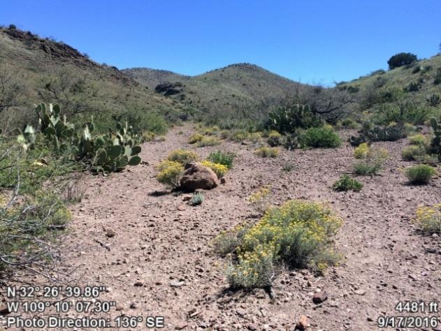
2 Peloncillos Mountains Wilderness Proposed LWC TABLE OF CONTENTS PREFACE: This Proposal was developed according to BLM Manual 6310 page 3 METHODS: The research approach to developing this citizens proposal page 5 Section 1: Overview of the Proposed Lands with Wilderness Characteristics Unit Introduction: Overview map showing unit location and boundaries page 8 provides a brief description of the unit Section 2: Documentation of Wilderness Characteristics The proposed LWC meets the minimum size criteria for roadless lands page 10 The proposed LWC is affected primarily by the forces of nature page 10 The proposed LWC provides outstanding opportunities for solitude and/or primitive and unconfined recreation page 12 Conclusion: The proposed area should be managed for protection of wilderness characteristics page 14 Section 3: Detailed Maps and Description of the Unit Boundary, Roads, Ways and Human Impacts Detail Maps with Photopoint Locations page 16 Narrative Description of the Proposed LWC Boundary and Vehicle Routes page 20 Whitehorse Unit Boundary Description page 20 Antelope Canyon Unit Boundary Description page 22 Engine Mountain Unit Boundary Description page 23 Section 4: Photopoint Data Data Tables and Geotagged Photographs to accompany the Detailed Boundary & Vehicle Routes Description page 25 Cover Photo: From atop a hill at photo point S1, along the wilderness inventory road that forms the southern boundary of the Whitehorse unit, this photo captures the rugged volcanic escarpment of the Peloncillo Mountains, and vegetation typical of upper Sonoran habitats: creosote, yucca, ocotillo, tobosa grass, and prickly pear. All photos by the authors Arizona Wilderness Coalition 2 ww.azwild.org
3 Peloncillos Mountains Wilderness Proposed LWC PREFACE: This Proposal was developed according to BLM Manual 6310 General Overview Instruction Memorandum and Manuals 6310 and 6320 set out the BLM s approach to protecting wilderness characteristics on the public lands. This guidance acknowledges that wilderness is a resource that is part of BLM s multiple use mission, requires the BLM to keep a current inventory of wilderness characteristics, and directs the agency to consider protection of these values in land use planning decisions. 1 In March 2012, the Bureau of Land Management issued updated manuals for inventorying and managing Lands with Wilderness Characteristics on public lands (hereafter often referred to as LWC s). These manuals provide the agency with direction for implementing its legal obligations to inventory and consider management of Lands with Wilderness Characteristics, including the Federal Land Policy and Management Act s provision that BLM preserve and protect certain public lands in their natural condition (43 U.S.C. 1701(a)(8)). Manual 6310 (Conducting Wilderness Characteristics Inventory on BLM Lands) guides the BLM on how to meet its obligations to inventory for and identify lands with wilderness characteristics. Manual 6320 (Considering Lands with Wilderness Characteristics in the BLM Land Planning Process) guides the BLM on the options available to address lands with wilderness characteristics in land use planning once they have been identified in the required inventory, such as putting management prescriptions in place to protect wilderness characteristics. The purpose of this report is to provide the BLM with recommendations for designation of Lands with Wilderness Characteristics in the Kingman Resource Area of northwestern Arizona, based on new, accurate, and up-to-date information according to Manual What does Manual 6310 require for the identification of LWC s? Minimum standards for LWC proposals are described in Manual 6310 in section.06.b.1. There are three things required in a citizens' wilderness proposal in order to meet the minimum standard for BLM to consider it in an inventory and to consider it as new information: Detailed map with specific boundaries; Detailed narrative of the wilderness characteristics; and Photographic documentation. Once there is new information that meets these standards, then as soon as practicable, the BLM shall evaluate the information, including field checking as needed and comparing with existing data to see if previous conclusions remain valid. Further, BLM will document its rationale and make it available to the public. (.06.B.2). This proposal report provides the three necessary criteria listed above. 1 Memorandum is available online at: 2 Manual 6310 is available online at : Arizona Wilderness Coalition 3 ww.azwild.org
4 Peloncillos Mountains Wilderness Proposed LWC What does Manual 6310 require for an area to be identified as an LWC? Requirements for determining lands have wilderness characteristics are found in section.06.c.2 of Manual Lands with Wilderness Characteristics must possess the following traits: Size Sufficient roadless area to satisfy size requirements (5,000 acres, of sufficient size to make management practicable or any roadless island of the public lands ; or contiguous with Wilderness, Wilderness Study Areas, USFWS areas Proposed for Wilderness, Forest Service WSAs or areas of Recommended Wilderness, National Park Service areas Recommended or Proposed for Designation). Naturalness Affected primarily by the forces of nature The criteria is apparent which depends on whether an area looks natural to the average visitor who is not familiar with the biological composition of natural ecosystems versus human affected ecosystems. This is an important distinction between ecological integrity and apparent. Human impacts Human impacts must be documented and some are acceptable so long as they are substantially unnoticeable ; Examples include trails, bridges, fire rings, minor radio repeater sites, air quality monitoring devices, fencing, spring developments, and stock ponds. Outside human impacts impacts outside the area are generally not considered, but major outside impacts should be noted and evaluated for direct effects on the entire area (the manual explicitly cautions BLM to avoid an overly strict approach ). Outstanding opportunities for either solitude or primitive and unconfined recreation The area does not have to possess both opportunities for solitude and primitive and unconfined recreation, nor does the area need to have outstanding opportunities on every acre; BLM cannot compare lands in question with other parcels; BLM cannot use any type of rating system or scale. Supplemental values Ecological, geological, scientific, scenic, educational or historical features should be documented where they exist, although they are not required traits. What does Manual 6310 require for the identification of the boundaries of an LWC? Boundaries should be based on wilderness inventory roads and rather than opportunities for solitude or primitive and unconfined recreation. For inventorying wilderness characteristics, BLM will use the road definition from FLPMA s legislative history; the term road and wilderness inventory road are interchangeable in this guidance. The AWC survey team took a very literal, maintenance-driven approach to road/way determination. Wilderness inventory roads are routes which have been: (1) improved and maintained (when needed), (2) by mechanical means (but not solely by the passage of vehicles), (3) to insure relatively regular and continuous use. Primitive routes or ways are transportation linear features located within areas that have been identified as having wilderness characteristics and not meeting the wilderness inventory road definition. Lands between individual human impacts should not be automatically excluded from the area; no setbacks or buffers allowed; boundaries should be drawn to exclude developed rights-of-way; undeveloped rights-of-way and similar possessory interests (e.g.,as mineral leases) are not treated as impacts to wilderness characteristics because these rights may never be developed ; areas can have wilderness characteristics even though every acre within the area may not meet all the criteria. Arizona Wilderness Coalition 4 ww.azwild.org
5 Peloncillos Mountains Wilderness Proposed LWC METHODS: The research approach to developing this citizens proposal The information presented in this report was developed systematically to ensure a comprehensive and accurate description of the proposed LWC that fulfills the citizens proposal requirements of Manual Our intent has been to effectively combine the analytical power of technology with the equally important elements of qualitative observation, to produce a suite of products that can be used to facilitate the protection of a variety of lands with wilderness characteristics across the Safford Resource Area, meeting the conservation objectives of Arizona Wilderness Coalition and the legal obligation for the BLM to preserve and protect certain public lands in their natural condition. STEP 1: GIS ROADLESS ANALYSIS The initial exercise in our inventory was to complete a geospatial analysis of the study area to identify potential roadless areas using a combination of Qgis, ESRI ArcGis, and Google Earth Pro. The BLM s Route Inventory dataset was queried for keywords that indicated that a route may be maintained, such as gravel-surfaced, 2WD use, Recent grading, and numerous other terms. Several rounds of this process were verified over color aerial imagery to assess the quality of the output. During this step, some errors in the dataset were corrected, such as incomplete line features or very inaccurate digitization. Additionally, we performed a visual assessment of aerial imagery for roads that appeared obviously maintained, and added an attribute column to mark these features as such. We also acquired railroad data, US Census Lidar data for Primary & Secondary Roads, Interstate highway data, and county-maintained roads data from Cochise County. In addition, we digitized natural gas pipeline corridors, telephone and power lines, and the proposed route for the SunZia transmission line. Each feature type was buffered by distances ranging from 10 feet for dirt roads, to 50 feet for interstates and powerlines, and the results were dissolved and unioned to develop one master feature dataset that represented probable wilderness inventory roads and rights-of-way corridors. These data were then used to clip BLM s Surface Management dataset into contiguous blocks of BLM land. Areas less than 5,000 acres were then deleted (unless contiguous to wilderness, WSA, or Proposed Wilderness), and the resultant output was a dataset of 52 units of BLM lands that were probable roadless areas. STEP 2: FIELD INVENTORY PRIORITIZATION Prior to visiting any sites on the ground, we assessed each initial roadless area polygon to determine where our resources would be most effectively deployed. Our objectives were to maximize field inventory efforts on the areas that we estimated would possess the most outstanding wilderness values, while also covering a broad geographic sample of the study area. Our determinations were informed by EIS documents, past wilderness inventory reports by BLM and AWC, research by The Nature Conservancy and the Sky Island Alliance, and geospatial data we acquired from BLM, US Forest Service, academic institutions, and the Arizona Game and Fish Department, including the Heritage Database. It is important to make clear that the units we decided not to inventory probably possess wilderness characteristics, but given available resources, we could not visit every unit. In addition to the units we are proposing as LWC s, we are also providing recommendations for areas we have identified as Potential LWC s. Those units should still be inventoried for wilderness characteristics. Arizona Wilderness Coalition 5 ww.azwild.org
6 Peloncillos Mountains Wilderness Proposed LWC STEP 3: FIELD PLANNING Trips to the field were strategic, focused efforts. For each unit, we developed a list of field inventory points that we endeavored to visit either by foot or vehicle. By using the BLM Route Inventory Dataset, the BLM Range Improvements dataset, the USGS Springs dataset, the Arizona Land Resources Information System Mines dataset, and USGS Topographic Maps, we identified potential impacts to and areas of potential supplemental value. These datasets were exhaustively examined on Google Earth to validate feature locations. Additionally, other inventory features were identified on the aerial imagery. Once the field inventory points were identified, they were loaded into MotionX GPS HD for ipad. Also, we loaded high-resolution color aerial imagery for our target units and the surrounding area, to assist in navigation, identification of landscape features, and location of hard to detect features. Finally, standard logistical planning steps were completed to ensure that our team would enjoy safe and efficient days in the field. STEP 4: FIELD INVENTORY From January to March, 2016, and again in September, 2016, our team dedicated more than 800 hours to inventorying lands with wilderness characteristics. Our objectives were: 1) to refine unit boundaries to confirmed wilderness inventory roads and impacts to ; 2) to identify and document primitive routes, ways, and trails; 3) locate and document minor impacts to that are permitted within LWC s; 4) identify and document opportunities for solitude and primitive recreation; and 5) discover and document supplemental values where they exist. The primary tool for documentation was GeoJot+ for iphone, a data collection app that allows the user to develop dropdown data tables that are attached to geotagged.jpeg digital photographs. In making determinations whether a route was a road versus a way, we returned to the legislative definition of a road (discussed earlier), closely assessed the history of maintenance, and considered the purpose (or lack thereof) of the route, the level of use, its connectivity, and other aspects. We are confident that upon verification, our determinations meet the intent of Manual STEP 5: FINAL ASSESSMENT, MAPPING, AND DATA COMPILATION After a field trip, data were loaded into GeoJot + Core for PC, where edits were made where necessary, and final determinations for unit boundaries were made. A range of products were developed from this application: 1) the photopoint data in Section 5 of this report, complete with tables and geotaggs; 2).kml files for Google Earth to visualize the photopoints across the landscape; and 3) a.kml file of scenic panoramas of the units, showcasing the immense beauty and wildness of our final unit proposals. It is the intent of AWC to share these interactive products with BLM to facilitate in the review of our proposals and to support our best efforts to put forth fair proposals in full transparency. Finally, edits were made to unit polygons in GIS, supplemental information was further explored, maps were developed, and the components of this report were produced. Arizona Wilderness Coalition is proud to share with the BLM this citizens proposal report and accompanying GIS data, the product of an intensive and science-based conservation process that furthers our collective goal to preserve and protect certain public lands in their natural condition. Arizona Wilderness Coalition 6 ww.azwild.org

7 Peloncillos Mountains Wilderness Proposed LWC Section 1: Overview of the Proposed Lands with Wilderness Characteristics In this report, we propose three separate units with wilderness characteristics that share contiguous boundary with the northern and northeastern borders of the Peloncillo Mountains Wilderness. These three units are natural extensions of the designated Wilderness, where the current boundary follows arbitrary ridgelines or section lines. Our unit proposals encompass contiguous BLM land up to private property lines, wilderness inventory roads, or other human impacts, like waterlines, dirt tanks, and water tanks. The photo above highlights the terrain and vegetation of the Whitehorse unit from the northern boundary road. The rolling hills and low mountains seen here, draped in grassland and scrub typical of the Apache Highlands Ecoregion, are entirely within the proposed LWC, and are similar to the landscape in the contiguous Wilderness area. Managing these units for their Wilderness Characteristics expands on the outstanding opportunities for primitive recreation and solitude that are established in the neighboring Wilderness area. Arizona Wilderness Coalition 7 ww.azwild.org


8 Peloncillos Mountains Wilderness Proposed LWC Unit Introduction: Overview map showing unit location & boundaries FUTURE SUNZIA TRANSMISSION LINE (APPROXIMATE) ARIZONA NEW MEXICO Bureau of Land Management PROPOSED LWC Unit Designated Wilderness/ Wilderness Study Area Former Wilderness Study Area The Peloncillo Mountains stretch for nearly 100 miles from the Gila River, into New Mexico, and then further south into Mexico, providing an important flyway for migratory birds. The Peloncillo Mountains Wilderness, about ten miles northeast of the farming town of San Simon, Arizona, is the largest block of protected land in the entire mountain range. The area was designated as Wilderness prior to consolidation of BLM land, and is in an area with a substantial amount of private land, so the original Wilderness Study Area boundary encompassed much less contiguous wild land that what we present here. The three units we propose as Lands with Wilderness Characteristics are natural extensions to the designated Wilderness as they border the Wilderness area where arbitrary boundaries were drawn. The three units contain grassland, juniper savanna, chaparral, and upper Sonoran succulent and scrub vegetation typical of the transitional area between the Apache Highlands and Sonoran Desert ecoregions. Cattle ranching is the primary use of the land currently, and we present a proposal that both seeks to protect more land and maintain the traditional use of the land by local ranchers by drawing boundaries to exclude range infrastructure from the units. Rock hounding and hunting are popular recreational uses of the area, and our proposal should not impact those uses. Opportunities for backpacking, horseback riding, and photography are outstanding in these Wilderness-contiguous units, where silence and solitude is plentiful. AZ/NM State Trust Land S4 Private Land Scenic Photos shown in report text Photo Data Points (Numbers shown in Sections 3 & 4) BLM Route Inventory Data Creeks, Canyons and Washes Map of Proposed LWC, showing photo data points, vehicle routes, and unit boundaries. Background map USGS topographic. Data: Google Earth, Bing, BLM, USGS, US Census, AZDOT, TWS, Field Survey. Projection: WGS 84 UTM Zone 12N Produced for Arizona Wilderness Coalition by Joe Trudeau, Hassayampa Forestry & Ecological. Sept mile 3 miles Arizona Wilderness Coalition 8 ww.azwild.org

9 Peloncillos Mountains Wilderness Proposed LWC Section 2: Documentation of Wilderness Characteristics This view over the eastern portion of the Whitehorse unit is from a hilltop to the north of the units northern boundary road. The unit boundary follows a road in the valley at photo center, which leads to a well and dirt tank on private land. The highest mountains, at left, are contained within the existing Wilderness area. The scene shown here is typical of the proposed LWC s, with rolling high-desert grassland, punctuated by stands of juniper on northern slopes, and areas of upper Sonoran vegetation (like the ocotillo shown here) on southern slopes. Arizona Wilderness Coalition 9 ww.azwild.org
10 Peloncillos Mountains Wilderness Proposed LWC Size Criteria The Peloncillo Mountains Wilderness Proposed LWC units meet the size criterion specified in BLM Manual All three proposed LWC units are contiguous to the Peloncillo Mountains Wilderness. The Whitehorse Proposed LWC unit contains about 12,446 acres of contiguous, roadless BLM land. The Antelope Canyon Proposed LWC includes approximately 2,378 acres of contiguous, roadless land under BLM ownership. The Engine Mountain Proposed LWC contains about 1,383 roadless, contiguous acres of BLM land. BLM Manual 6310 states that areas under 5,000 acres are eligible for LWC determinations if they are contiguous with lands which have been formally determined to have wilderness or potential wilderness values, or any Federals lands managed for the protection of wilderness characteristics. Because the Antelope Proposed LWC and the Engine Mountain Proposed LWC are contiguous to the Peloncillo Mountains Wilderness, these units meet the size qualifications regardless of the fact that they are less than 5,000 acres in size. None of the three proposed LWC units enclose any private or other agency inholdings; all private lands encountered are provided with access along unit boundaries or cherrystemmed roads. Naturalness The Peloncillo Mountains Wilderness Proposed LWCs are affected primarily by the forces of nature. The works of humans are substantially unnoticeable and relatively minor. The landscape contained within the proposed LWC units is wild and incredibly scenic. Human impacts are few and do not detract from the of the units, which are largely undisturbed. Most human disturbances in the area are excluded from the proposed LWCs, but there are some rather minor signs of human activities within the proposed units that are few and far between. The Whitehorse unit excludes most human impacts with boundary adjustments and fourcherrystemmed routes; the longest of which is one and three-quarter miles, and the shortest is just over a tenth of a mile in length. The cherrystemmed roads lead to a windmill (point 25), a stone dam (point 8) and a well and tank (point 11). Despite the cherrystems which are all relatively faint routes that fade into the landscape from a short distance away this proposed LWC contains a large, unfragmented unit core lacking any human impacts. The only human infrastructure located in our inventory within the Whitehorse Proposed LWC includes a buried waterline which parallels the boundary road (point 15), a water trough (point 22) and a feed station (point 28).These are not major impacts and they are substantially unnoticeable to the average visitor. Indeed, the BLM in Manual 6310 uses water troughs as an example, saying that the presence of a water trough is a relatively minor human impact on, and may be considered substantially unnoticeable. Certainly, neither of the other impacts mentioned above (waterline & feed station) are more substantial than a water trough. The Whitehorse LWC unit only contains four primitive routes, or ways, seen in points 12, 26, 27, and 33. As the photographs document, these ways do not substantially affect ; by definition primitive routes do not necessarily detract from wilderness characteristics or. Arizona Wilderness Coalition 10 ww.azwild.org
, and these were excluded with no impact to.")
11 Peloncillos Mountains Wilderness Proposed LWC The Antelope Canyon Proposed LWC unit contains very few human imprints. Some ranching infrastructure can be found around the edges of the unit (points 45, 46, 49 & 51), and these were excluded with no impact to. A buried water line (points 40-42, & 50) serves as a significant portion of the unit boundary, but as the photopoints illustrate; this water line is substantially unnoticeable to the average visitor. According to BLM Manual 6310, barely visible linear disturbances, such as this buried water line, should not disqualify an area for having apparent. Using the waterline as the unit boundary sets the road back several hundred feet from the unit, thus increasing the wilderness characteristics in the unit. There is only one primitive route (point 52) that enters the proposed LWC, and it does not substantially detract from the of the unit as a whole. Point 53 displays the image of a feed station that was the only other minor human impact documented within this unit. The Engine Mountain Proposed LWC is virtually indistinguishable from the adjacent Wilderness as far as is concerned. This proposed LWC unit does not contain many manmade disturbances. Most impacts were documented around the edges of the unit, and therefore, excluded from the proposed LWC. There is one earth-bermed tank within the LWC, but we could not locate any access roads or ways leading to it. Additionally, stock ponds are among the human-made features that may be considered substantially unnoticeable according to BLM Manual 6310.There are no primitive routes within the Engine Mountain Proposed LWC, an extraordinary fact considering that most of this unit is a flat desert plain. The unit boundary road for the Engine Mountain unit can be seen in the foreground, with the unit itself encompassing most of the flat plain between this point and the Peloncillo Mountains. The western boundary of the Engine Mountain Unit is the Wilderness boundary, an arbitrary line midway between section lines cutting due north to south. Engine Mountain is the locomotive-shaped peak on the right. Arizona Wilderness Coalition 11 ww.azwild.org
12 Peloncillos Mountains Wilderness Proposed LWC The Peloncillo Mountains Wilderness Proposed LWC units that we propose are largely untrammeled by man as we carefully documented human impacts and worked to exclude them from the units. The three proposed LWC units combined contain only five primitive routes within their boundaries, making for an incredibly natural landscape contiguous to designated Wilderness. This is a very low number of primitive routes penetrating the unit boundaries; a rare attribute of any piece of undeveloped land these days. While there are ranching activities occurring on these lands proposed for LWC designation, it is common to see these very same activities and their impact features (such as stock ponds) within designated Wilderness areas. Grazing activities and imprints do not detract from the of the Peloncillo Mountains Proposed LWCs in any considerable way according to the standards laid forth in BLM Manual In fact, the grazing seems to be very well managed, as the native grasslands appear exceptionally healthy and robust. The grasslands of the Peloncillo Mountains seem particularly sensitive to disturbance; any human disturbance could have visual impacts that last for decades. Mountains in this range have such graceful curves sloping in and out of canyons and other striking drainage features with highly aesthetic natural vegetative patterns. The largely undisturbed nature of these hillsides is an essential element of their wild beauty that deserves LWC designation in order to protect their outstanding levels of and wilderness characteristics. It is uncommon to find native grasslands in such good conditions, as they are in the proposed LWCs, making it all the more important to protect the wilderness characteristics of this land. As this report documents, the human impacts that do exist are minor and can be considered substantially unnoticeable to the average visitor. Solitude & Recreation The Peloncillo Mountains Wilderness LWC units provide a wild landscape for outstanding experiences of solitude and primitive and unconfined recreation. All three proposed LWC units are contiguous with the Peloncillo Mountains Wilderness, and therefore inherit the outstanding wilderness characteristics present within the designated Wilderness. Such characteristics have already been documented within the Wilderness and designating the proposed LWCs would improve the available opportunities for experiencing outstanding solitude and primitive and unconfined recreation. It is easy to find high-quality opportunities for being alone in remote country within the Peloncillo Mountains Wilderness Proposed LWCs. The LWC units are set far from population centers among beautiful rolling hills that provide ample topographic relief for shielding the sights and sounds of others. Canyons and draws lead visitors into small basins and isolated areas with exceptional wilderness characteristics and outstanding opportunities for solitude. The Whitehorse Proposed LWC includes roughly 12,446 acres; even as a stand-alone unit this is more than enough to experience authentic solitude. Furthermore, scattered juniper woodlands within all three units provide vegetative screening that serves to shelter visitors from each other. Indeed, our inventory team did not see, hear or encounter any other individuals in the days that we spent exploring the area. There is no doubt that those seeking solitude will discover excellent opportunities in the isolated settings of the proposed LWC units. Arizona Wilderness Coalition 12 ww.azwild.org

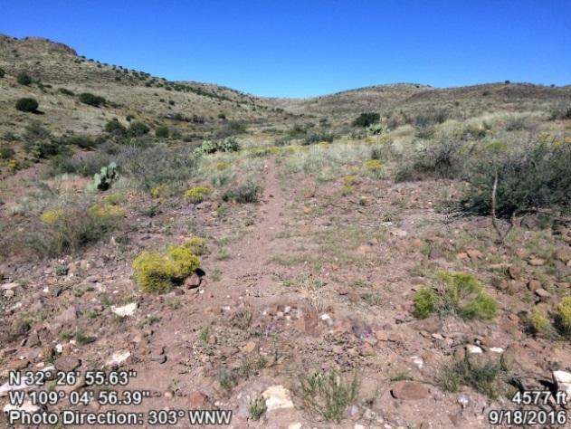
13 Peloncillos Mountains Wilderness Proposed LWC Outstanding opportunities for primitive and unconfined recreation exist throughout the proposed LWCs. The Peloncillo Mountains Wilderness area contains approximately 19,800 acres. The Lands with Wilderness Characteristics that are being proposed cover approximately 16,200 acres total. Combined that amounts to approximately 36,000 acres of roadless land with spectacular wilderness characteristics and outstanding opportunities for long, rugged adventures through a rough, untamed and secluded landscape. Backpackers or horse packers can easily put together a twenty mile loop within the existing Wilderness. That loop could be extended by tens of miles with the additional terrain contained by the proposed LWC units; providing outstanding opportunities for outdoor recreationists looking for longer expeditions over extended periods of time without having to backtrack. Numerous canyons cut through the undulating terrain within the Wilderness and the proposed LWCs providing outstanding opportunities for risky navigation and difficult route-finding. This vast landscape is ideal for primitive and unconfined recreation. Day adventurers will find a plethora of outstanding opportunities for primitive and unconfined recreation throughout the land proposed for LWC designation. Hikers can enjoy cross-country travel through the picturesque grasslands and woodlands. Climbers looking for more of a challenge can venture into the Wilderness to summit Horsefoot Mountain at almost 6,000 feet in elevation. This incredibly rugged mountain also provides stunning features for photographers to capture. In addition, the lovely grasslands and beautiful juniper woodlands throughout the LWCs and the Wilderness provide excellent opportunities for photography. The light plays across this unspoiled landscape in magical ways offering exceptional perspectives of the land s wild characteristics. Bird watching and sightseeing for botanical and zoological features amidst the incredible scenery within this part of the Peloncillo Mountains is also quite outstanding. The connectivity to the adjacent Wilderness makes the opportunities for all of these various forms of primitive recreation that much more exemplary. From a hilltop across Loop Road, this view over the Antelope Canyon unit shows the expansive grasslands and juniper savannas that define this region. Engine Mountain can be seen just over the ridge, where the units Wilderness-contiguous boundary follows and arbitrary section line. Arizona Wilderness Coalition 13 ww.azwild.org
14 Peloncillos Mountains Wilderness Proposed LWC Hunting prospects are absolutely outstanding within the proposed LWCs, especially when considered along with the contiguous Wilderness area. Native desert grasslands found within all three proposed units provide exceptional habitat for hunting game. Intact desert grasslands are becoming less common due to human disturbance. As a result, native grasslands that remain hold great intrinsic value, and it is important to protect them from potential threats. The terrain and vegetation in the proposed LWCs are perfect for backcountry hunting. Across Arizona, many grasslands have been invaded by brush, making it hard to travel by foot. The grasslands in the LWCs are largely not being invaded by brush and are ideal for hunting by foot. Some species of economic and recreational importance found within the proposed LWC units include band-tailed pigeon, bighorn sheep, Gambel s quail, javelin, scaled quail, mountain lion, mule deer, pronghorn (in Antelope & Engine Mtn. Proposed LWCs), and white-winged dove (see Primitive recreation in such healthy desert grasslands is absolutely outstanding. So many native grasslands in Arizona have been overgrazed and lack their original stunning beauty. However, the grasslands in the proposed LWCs do not seem to be overgrazed and appear in excellent condition. Taking this into consideration, the solitude and primitive recreation opportunities present within the proposed LWC units stand apart from those available elsewhere. Conclusion The Arizona Wilderness Coalition recommends to the Bureau of Land Management that the proposed area should be managed for protection of wilderness characteristics according to the policies established in BLM Manuals 6310 and In this report, we have provided the requirements for a citizens proposal, and documented that the proposed unit meets the criteria for size,, solitude, and primitive recreation. The scenic quality of these wilderness contiguous units is spectacular, featuring a mix of native grasslands, diverse chaparral species, and upper Sonoran vegetation. Indisputably, there are outstanding opportunities for experiencing solitude and primitive and unconfined recreation within the existing Peloncillo Mountains Wilderness. The Peloncillo Mountains Wilderness Proposed LWCs also contain their own outstanding wilderness characteristics. Furthermore, because the boundaries between the Wilderness area and the proposed LWC s are arbitrary (not wilderness inventory roads, rights of ways, property boundaries, etc.), the proposed LWC units automatically inherit the undeniably outstanding wilderness characteristics present within the Peloncillo Mountains Wilderness. Arizona Wilderness Coalition 14 ww.azwild.org

15 Peloncillos Mountains Wilderness Proposed LWC Section 3: Detailed Maps & Description of the Unit Boundary, Roads, Ways and Human Impacts From the unit boundary along a road in Antelope Canyon, this view is looking up an unnamed valley in the 2,378-acre Antelope Canyon Proposed LWC, towards Engine and Horsefoot Mountains in the Peloncillo Mountains Wilderness. Arizona Wilderness Coalition 15 ww.azwild.org


16 Peloncillos Mountains Wilderness Proposed LWC Detail Maps with Photopoint Locations DETAIL MAP 1: WHITEHORSE - ENTIRE UNIT Whitehorse: ~12,446 acres contiguous to the Peloncillo Mountains Wilderness The narrative description of the unit boundary and other data starts at the northwestern corner of the unit and progresses in a clockwise direction. It is divided into four boundary segments: Segment A is the northern boundary from points 1 to 16, following vehicle routes and private land Segment B is the eastern boundary from points 17 to 19, following a road and private land Segment C is the southern boundary, following the Wilderness boundary, private land, and points 20 to 22 on a road Segment D is the western boundary from private land to point 36, following wilderness inventory roads Arizona Wilderness Coalition 16 ww.azwild.org

17 Peloncillos Mountains Wilderness Proposed LWC Detail Maps with Photopoint Locations DETAIL MAP 2: WESTERN PORTION OF WHITEHORSE UNIT *note: the route used as the unit boundary from point 1 through 5 would not typically meet the criteria for a wilderness inventory road, but we have used it as the boundary to keep the unit south of the SunZia transmission line corridor and to exclude private property. Arizona Wilderness Coalition 17 ww.azwild.org

18 Peloncillos Mountains Wilderness Proposed LWC Detail Maps with Photopoint Locations Wilderness Boundary follows wash Road DETAIL MAP 3: EASTERN PORTION OF WHITEHORSE UNIT *a note on Cherrystems: BLM Manual 6310 clearly permits the use of cherrystem roads to exclude human impacts from a unit of Land with Wilderness Characteristics. The existing Peloncillo Mountains Wilderness has at least four cherrystemmed roads which lead to range developments or private land, so the cherrystems we propose here are not beyond the precedent set by BLM in establishing the designated Wilderness. Arizona Wilderness Coalition 18 ww.azwild.org

19 Peloncillos Mountains Wilderness Proposed LWC Detail Maps with Photopoint Locations Road DETAIL MAP 4: ANTELOPE CANYON AND ENGINE MOUNTAIN UNITS Antelope Canyon Unit: ~2,378 acres contiguous to the Peloncillo Mountains Wilderness Segment A is the eastern boundary, following a buried waterline and associated livestock waters Segment B is the southern boundary, following roads that lead to private land and a well and tank, then following the Wilderness boundary and private land Segment C is the western boundary, which follows a buried waterline that leads from a tank on private land to livestock waters such as the one at point 49 Segment D is the northern boundary, which follows the wilderness inventory road down Antelope Canyon Engine Mountain Unit: ~1,383 acres contiguous to the Peloncillo Mountains Wilderness Segment A is the northern boundary, which follows roads and some fenceline Segment B is a short section that follows the Arizona New Mexico state line Segment C is the southern boundary, which follows the road into the Lazy B Ranch, the private property line, and the Wilderness boundary Segment D is the western boundary, which follows the Wilderness boundary north to point 47 Arizona Wilderness Coalition 19 ww.azwild.org
20 Peloncillos Mountains Wilderness Proposed LWC Narrative Description of the Proposed LWC Boundary & Vehicle Routes Whitehorse Unit - Segment A: North Boundary General Description: From the northwest corner, the northern unit boundary is comprised of a primitive route (points 2 & 4). This way is used as the unit boundary in order to avoid future conflict with the approved SunZia Powerline route, which will be located nearby to the northwest. The BLM property line with a private parcel serves as the next portion of this boundary segment. Point 5 shows an image of the road that forms the next part of this boundary segment. Point 14 shows a dry wash that serves as a short segment of the LWC unit boundary. The BLM property line with a private parcel becomes the proposed LWC unit boundary once again. The last portion of this boundary segment is another wilderness inventory road (point 16). Boundary Adjustments: -Point 14 was taken near the unit boundary looking to the southeast down a dry natural wash that serves as a short segment of the LWC unit boundary. This wash is used for a portion of the boundary in order to exclude some ranch impacts to the northeast and to connect the proposed unit boundary to the BLM property line. Cherrystems: -Point 6 depicts a road that accesses Indian Tanks (point 8). Point 7 displays another image of this wilderness inventory road with some ranching equipment; both are excluded from the proposed LWC unit. -Points 9 and 10 show a cherrystem that leads to an earth-bermed tank (point 11) which is also excluded from the proposed LWC. Ways: -Points 12 and 13 were taken looking down a primitive route that leads from the end of a cherrystem. As the photographs document, all vehicular use of this route ends at the tank (point 11) where the cherrystem ends and becomes an unmaintained way. Associated Human Impacts: -Point 1 displays an image of some ranch infrastructure that is excluded from the proposed LWC near the northwest unit corner. Because these impacts are excluded from the proposed LWC unit, they do not impact the within the unit. -Point 3 was taken looking at an old earth-bermed water tank that no longer appears to be functional and has been excluded from the proposed unit. -Point 15 documents a buried waterline that enters the LWC unit and does not substantially detract from the of the unit as a whole. Whitehorse Unit - Segment B: East Boundary General Description: A wilderness inventory road (points 17-19) forms most of the proposed eastern unit boundary. The southern end of this unit boundary segment is the BLM property line with a private parcel. There are no boundary adjustments, cherrystems, primitive ways, or major human impacts along the eastern boundary segment. Arizona Wilderness Coalition 20 ww.azwild.org
21 Peloncillos Mountains Wilderness Proposed LWC Whitehorse Unit - Segment C: South Boundary General Description: This boundary segment is comprised of the Peloncillo Mountains Wilderness boundary, the BLM property line with a private parcel, and a wilderness inventory road (point 21). Associated Human Impacts: -Point 20 shows a windmill and water tanks that are excluded from the proposed LWC along the unit boundary road. These human impacts do not detract from the of the proposed unit because they are not major disturbances, and they are not located within the LWC unit. -Point 22 displays an image of a concrete tank that lies inside the proposed LWC, but is so small that it does not substantially detract from. There are no boundary adjustments or cherrystems along the southern boundary segment, as well as no primitive ways that enter the proposed LWC unit. Whitehorse Unit - Segment D: West Boundary General Description: This boundary segment is the BLM property line with private property and two wilderness inventory roads seen in points 23, 29 and 36. Cherrystems: -Point 24 was taken looking northeast up a cherrystem that leads to some ranch infrastructure (point 25) which is also excluded from the proposed LWC unit. Point 26 documents that most vehicular use ends at the windmill and water tank, after which the cherrystem becomes an unmaintained way. -Point 31 documents another cherrystemmed route that leads to an earth-bermed tank (point 32) that is also excluded from the proposed unit. Ways: -As mentioned above, point 26 illustrates that most vehicular use ends at the windmill at the end of a cherrystem, and the unmaintained way seen in point 26 continues into a natural dry wash. -Point 27 displays the image of a primitive route that is kept open solely by the passage of vehicles and leads to a feed station (point 28). -Point 30 shows an old route that is no longer used, and has naturally revegetated and been reclaimed by nature. -After the cherrystem seen in point 31, the route turns to an unmaintained way that is kept open solely by the passage of vehicles (points 33 & 34) and ends (point 35) with no apparent purpose. There are no boundary line adjustments or further human impacts located along the western boundary segment. Arizona Wilderness Coalition 21 ww.azwild.org
22 Peloncillos Mountains Wilderness Proposed LWC Antelope Canyon Unit - Segment A: East Boundary General Description: A buried waterline (points 40-42) that runs parallel to the Loop Road (points 37 & 39) serves as the proposed LWC unit boundary for most of the eastern boundary segment. The next portion of this boundary segment is comprised of the BLM property line with a private parcel of land. The remainder of the eastern boundary is a wilderness inventory road seen in point 43. Ways: -Aerial imagery shows some vehicle tracks that, as point 38 illustrates, do not exist on the ground. There are no boundary line adjustments, cherrystems or other associated human impacts along the proposed eastern LWC unit boundary. Antelope Canyon Unit - Segment B: South Boundary General Description: The proposed southern unit boundary is comprised of a wilderness inventory road (point 44) that eventually leads to the Wilderness. The remainder of this boundary segment is the Peloncillo Mountains Wilderness boundary and the BLM property line with a private parcel of land. Boundary Adjustments: -In order to exclude the human impacts seen in points 45 & 46 (discussed below) the proposed unit boundary follows a short segment of fence line. Cherrystems: There are no cherrystems along this boundary segment. Ways: -Vehicles traveling along the road (unit boundary) seen in point 44 can drive to some ranch infrastructure near, but excluded from the Wilderness. In aerial imagery, it appears that there are tracks of some sort leading from the Wilderness into the proposed LWC. However, as point 48 illustrates, this old way is closed and gated, and receives no vehicular use. Associated Human Impacts: -Points 45 and 46 display images of some ranch infrastructure that is located directly along the boundary road and has been excluded from the proposed LWC unit. These corrals appear to be out of order and because they are outside of the LWC unit, they do not detract from within the proposed unit. Antelope Canyon Unit - Segment C: West Boundary General Description: The entire western unit boundary follows a buried waterline (point 50). Associated Human Impacts: -Point 49 was taken looking at a livestock watering tank located along the proposed LWC unit boundary that has been excluded from the unit, and therefore, does not detract from the of the unit itself. Arizona Wilderness Coalition 22 ww.azwild.org
23 Peloncillos Mountains Wilderness Proposed LWC There are no boundary line adjustments, primitive ways, or cherrystems along the western LWC unit boundary. Antelope Canyon Unit - Segment D: North Boundary General Description: The entire northern boundary is comprised of a wilderness inventory road seen in point 55. Boundary Adjustments: -The proposed LWC unit boundary excludes a livestock watering tank (point 51) directly along the boundary road. Ways: -Point 52 depicts a primitive route that is not maintained and is kept open solely by the passage of vehicles. This way ends at some feed buckets seen in point 53. -Point 54 was taken looking at an old way that is no longer used and has been reclaimed by nature. There are no cherrystems or additional human impacts along the northern boundary segment. Engine Mountain Unit - Segment A: North Boundary General Description: The proposed northern unit boundary is comprised of two wilderness inventory roads (point 44 & 56-58). Boundary Adjustments: -In order to exclude the human impacts seen in points 45 & 46 (discussed below) the proposed unit boundary follows a short segment of fence line. Associated Human Impacts: -Points 45 and 46 display images of some ranch infrastructure that is located directly along the boundary road and has been excluded from the proposed LWC unit. These corrals appear to be out of order and because they are outside of the LWC unit, they do not detract from within the proposed unit. There are no cherrystems or primitive routes that enter the proposed unit along this boundary segment. Engine Mountain Unit - Segment B: East Boundary General Description: The eastern boundary is the Arizona/New Mexico state line, as well as the eastern boundary of the Safford Field Office. There are no boundary line adjustments, cherrystems, ways, or associated human impacts along the eastern boundary segment. Arizona Wilderness Coalition 23 ww.azwild.org
24 Peloncillos Mountains Wilderness Proposed LWC Engine Mountain Unit - Segment C: South Boundary General Description: This boundary segment is comprised of a wilderness inventory road (points 59 & 60), the BLM property line with private land, and the Peloncillo Mountains Wilderness boundary. There are no boundary line adjustments, cherrystems, ways, or associated human impacts along the southern boundary segment. Engine Mountain Unit - Segment D: West Boundary General Description: The entire western boundary of the proposed LWC unit is the Peloncillo Mountains Wilderness boundary. As point 47 illustrates, this is an arbitrary line; there is no visual difference between Wilderness and non-wilderness. There are no boundary line adjustments, cherrystems, primitive routes, or associated human impacts along the western boundary segment. Arizona Wilderness Coalition 24 ww.azwild.org


25 Peloncillos Mountains Wilderness Proposed LWC Section 4: Photopoint Data Point 1 4-WD Trucks Purpose Ranching Maintenance Old evidence years ago Determination Roads junction at unit corner Unit corner, showing excluded well and tanks. notes minimally affects Point 2 4-WD Trucks Purpose Ranching Maintenance Likely if needed Determination Way Typical Condition of Route/Way Very grassy but using as unit notes boundary avoids future conflict with SunZia Powerline route Point 3 Route name N/A Construction N/A N/A Purpose Earthen-bermed tank Maintenance N/A Determination Excluded Livestock Watering/Feedin g station notes minimally affects Other notes Excluded from proposed unit Arizona Wilderness Coalition 25 ww.azwild.org


26 Peloncillos Mountains Wilderness Proposed LWC Point 004 Construction Probably only bladed once 4-WD Trucks, infrequent Purpose Private land access Maintenance None Determination Way Good section of route at private land boundary notes Best section of route Unit Boundary because of access Other notes to private land and to keep unit south of SunZia Powerline route Point 5 4-WD Trucks/UTV's Purpose Corral and wells Maintenance Likely if needed Typical Condition of Route/Way at BLM line notes minimally affects Point 6 Route name Indian Tanks access Construction Probably only bladed once UTV Purpose Dam and pond Maintenance Likely if needed Typical Condition of Route/Way notes minimally affects Other notes Cherrystem Arizona Wilderness Coalition 26 ww.azwild.org


27 Peloncillos Mountains Wilderness Proposed LWC Point 7 Route name Indian Tanks Construction Probably only bladed once 4-WD trucks Purpose Well/Water tanks Maintenance Likely if needed Typical Condition of Route/Way notes Recent use Other notes Cherrystem 007 Point 8 Route name N/A Construction N/A N/A Purpose Concrete and stone dam Maintenance N/A Determination Excluded from LWC Concrete and stone dam notes Other notes 008 Point 9 Occasional trucks and UTV's Purpose Water tank and trough Maintenance Likely if needed Typical Condition of Route/Way notes minimally affects Other notes Cherrystem to tank 009 Arizona Wilderness Coalition 27 ww.azwild.org


28 Peloncillos Mountains Wilderness Proposed LWC Point 10 Construction Probably only bladed once 4-WD trucks Purpose Well/Water tanks Maintenance Likely if needed Typical Condition of Route/Way notes Other notes Cherrystem 010 Point 11 Construction Probably only bladed once 4-WD trucks Purpose Well/Water tanks Maintenance Likely if needed Tank notes Excluded from unit Other notes End of Cherrystem 011 Point 12 Construction Probably only bladed once No sign of vehicles past water tank Purpose No purpose past water tank Maintenance None Determination Way Route fades after tank notes minimally affects Other notes None 012 Arizona Wilderness Coalition 28 ww.azwild.org


29 Peloncillos Mountains Wilderness Proposed LWC Point 13 Probably only Construction bladed once No sign of vehicles past water tank No apparent Purpose purpose Maintenance None Determination Way Typical Condition of Route/Way notes Other notes Point 14 Route name N/A Boundary road Construction seen crossing in foreground N/A Purpose Wash Maintenance Determination Natural Wash Natural Wash used as boundary Boundary segment to notes connect to private land Mtn in background is in unit; Wilderness Other notes area starts on other side of highest point. Point 15 Route name N/A Construction Excavated N/A Purpose N/A Maintenance N/A Determination Waterline Buried waterline notes Other notes Arizona Wilderness Coalition 29 ww.azwild.org


30 Peloncillos Mountains Wilderness Proposed LWC Point 16 4-WD Trucks Purpose Private land access Maintenance Likely if needed Typical Condition of Route/Way notes minimally affects Point 17 4-WD Trucks Private land Purpose access/ranching/ recreation Maintenance 5-10 years ago Typical Condition of Route/Way notes minimally affects Point 18 4-WD Trucks Earthen-bermed Purpose tank on private land Maintenance 5-10 years ago Junction of Routes/Ways notes minimally affects Arizona Wilderness Coalition 30 ww.azwild.org


31 Peloncillos Mountains Wilderness Proposed LWC Point 19 4-WD Trucks and UTV's Purpose Dirt tanks on private land Maintenance 5-10 years ago Typical Condition of Route/Way minimally affects showing notes faint nature of route & blending with vegetation Point 20 4-WD trucks Purpose Well/Water tanks Maintenance Likely if needed Ranch infrastructure excluded from unit. Trough and tank notes are full and in working order. Point 21 4-WD trucks Purpose Well/Water tanks Maintenance Likely if needed Boundary Road notes Arizona Wilderness Coalition 31 ww.azwild.org


32 Peloncillos Mountains Wilderness Proposed LWC Point 22 Route name N/A Construction N/A N/A Purpose Well/Water tanks Maintenance N/A Determination N/A Concrete water tank and scattered black piping notes Minimally affects Other notes Point 23 4-WD Trucks Purpose Private land access/ranching Semi-recent Maintenance evidence years ago Typical Condition of Route/Way notes Point 24 4-WD Trucks Purpose Windmill Maintenance Old evidence years ago Typical Condition of Route/Way notes Other notes Cherrystem Arizona Wilderness Coalition 32 ww.azwild.org


33 Peloncillos Mountains Wilderness Proposed LWC Point 25 Route name N/A Construction N/A N/A Purpose Ranching Maintenance N/A Determination N/A Excluded Windmill/Tank notes Full and working properly. Other notes Cherrystem 025 Point 26 Construction No evidence Most use ends at windmill Purpose No apparent purpose Maintenance None Determination Way Typical Condition of Route/Way notes Very low use Other notes 026 Point 27 Construction Probably only bladed once 4-WD trucks Purpose Feed station Maintenance None Determination Way Typical Condition of Route/Way notes Kept open solely Other notes by vehicle passage 027 Arizona Wilderness Coalition 33 ww.azwild.org


34 Peloncillos Mountains Wilderness Proposed LWC Point 28 Construction Probably only bladed once 4-WD trucks Purpose Feed station Maintenance None Determination Way Feed station notes Kept open solely Other notes by vehicle passage 028 Point 29 4-WD Trucks Purpose Ranching Maintenance Old evidence years ago Typical Condition of Route/Way notes Roadside berms 029 Point 30 Construction Probably only bladed once None Purpose No apparent purpose Maintenance None Determination Reclaimed Revegetated notes No use Other notes Does not affect 030 Arizona Wilderness Coalition 34 ww.azwild.org


35 Peloncillos Mountains Wilderness Proposed LWC Point 31 Probably only Construction bladed once 4-WD Trucks Earthen-bermed Purpose tank Likely if needed Maintenance up to dirt tank to dirt tank Junction of Routes/Ways notes minimally affects Cherrystem to Other notes tank Point 32 Construction N/A N/A Earth-bermed Purpose tank Maintenance Non Determination N/A Earth-bermed tank The route has significantly less notes use after the bermed tank. Other notes Point 33 Construction No evidence 4-WD Trucks Purpose None apparent Maintenance None Determination Way Revegetating route and dirt tank in background notes minimally affects Kept open solely by passage of vehicles. Dirt Other notes tank is excluded by short cherrystem Arizona Wilderness Coalition 35 ww.azwild.org


36 Peloncillos Mountains Wilderness Proposed LWC Point 34 Construction No evidence 4-WD trucks Purpose No apparent purpose Maintenance None Determination Way Typical Condition of Route/Way notes Narrow corridor Kept open solely Other notes by vehicle passage Point 35 No Construction evidence/maybe bladed once 4-WD Trucks Purpose None apparent Maintenance None Determination Way End of route turnaround notes minimally affects Kept open solely Other notes by passage of vehicles Point 36 4-WD Trucks Earth-bermed Purpose tank Likely if needed, Maintenance last bladed 5+ years ago Typical Condition of Route/Way notes Arizona Wilderness Coalition 36 ww.azwild.org


37 Peloncillos Mountains Wilderness Proposed LWC Point 37 Route name Loop Road 2-WD Passenger vehicle Purpose Camping Maintenance Likely if needed Sign notes Other notes Unit boundary parallels road 037 Point 38 Route name N/A Construction N/A N/A Purpose Nothing Maintenance N/A Determination N/A Nothing No vehicle tracks notes present on the ground. Aerial imagery Other notes shows vehicle tracks. Point 39 Route name Loop Road 4-WD Trucks Private land Purpose access and ranching Semi-recent Maintenance evidence years ago Showing road and adjacent buried waterline notes minimally affects Arizona Wilderness Coalition 37 ww.azwild.org


38 Peloncillos Mountains Wilderness Proposed LWC Point 40 Construction Excavated N/A Purpose Waterline Maintenance Likely if needed Determination Waterline Buried waterline notes Minimally affects 040 Point 41 Construction Excavated N/A Purpose Waterline Maintenance Likely if needed Determination Waterline Waterline notes Minimally affects 041 Point 42 Route name N/A Construction Excavated N/A Purpose Waterline Maintenance Likely if needed Determination Waterline Buried waterline leading off of private land notes minimally affects 042 Arizona Wilderness Coalition 38 ww.azwild.org


39 Peloncillos Mountains Wilderness Proposed LWC Point 43 4-WD Trucks Purpose Private land access Semi-recent Maintenance evidence years ago Junction of Routes/Ways Leads to antique cabins, dirt tank, notes and solar well which feeds buried pipeline Point 44 Construction Probably only bladed once 4-WD trucks & UTV's Leads to well & Purpose tank at exclusion in Wilderness boundary. Maintenance None Junction of Routes notes minimally affects Point 45 Construction Probably only bladed once 4-WD trucks & UTV's Purpose Well/Water tanks Maintenance None Corral notes Excluded from LWC unit Arizona Wilderness Coalition 39 ww.azwild.org


40 Peloncillos Mountains Wilderness Proposed LWC Point 46 Probably only Construction bladed once 4-WD trucks & UTV's Purpose Ranching Maintenance None Corral Equipment appears to be out notes of order & abandoned. Unit Other notes Boundary/Corral excluded Point 47 Route name N/A Construction N/A N/A Purpose N/A Maintenance N/A Determination N/A Looking due south down wilderness boundary. No visual difference notes between Wilderness and non-wilderness. Point 48 Construction No evidence Cattle Purpose Ranching Maintenance N/A Determination Trail Gate notes minimally affects May have buried Other notes waterline but unsure Arizona Wilderness Coalition 40 ww.azwild.org


41 Peloncillos Mountains Wilderness Proposed LWC Point 49 Buried waterline Construction from hilltop tank on private land to this trough 4-WD trucks & UTV's Purpose Water trough Maintenance Likely if needed Determination Way leads to trough Livestock Watering/Feedin g station notes minimally affects Point 50 Route name N/A Construction Excavated N/A Purpose Buried waterline Maintenance N/A Determination Waterline Revegetated waterline trench notes minimally affects Point 51 Route name Along boundary road Construction Excavated waterline Cattle Purpose Water Maintenance Likely if needed Determination N/A Trough along buried pipeline notes minimally affects Other notes Excluded from LWC unit 051 Arizona Wilderness Coalition 41 ww.azwild.org


42 Peloncillos Mountains Wilderness Proposed LWC Point 52 Construction Maybe only bladed once 4-WD Trucks Purpose Ranching Maintenance None Determination Way Typical Condition of Route/Way notes minimally affects Kept open solely Other notes by passage of vehicles Point 53 Construction Maybe bladed only once 4-WD trucks Purpose Feed buckets Maintenance None Determination Way Feed buckets notes Minimally affects Kept open solely Other notes by vehicle passage Point 54 Construction No evidence None Purpose None apparent Maintenance None Determination Reclaimed Revegetated notes Other notes Does not affect Arizona Wilderness Coalition 42 ww.azwild.org


43 Peloncillos Mountains Wilderness Proposed LWC Point WD Trucks and UTV's Ranching and Purpose private land access Old evidence; last Maintenance maintained 2-4 years ago Typical Condition of Route/Way notes Point WD Trucks Ranching and Purpose private land access Semi-recent Maintenance evidence years ago Typical Condition of Route/Way notes Point 57 4-WD Trucks Private land Purpose access and ranching Semi-recent Maintenance evidence years ago Typical Condition of Route/Way notes Arizona Wilderness Coalition 43 ww.azwild.org


44 Peloncillos Mountains Wilderness Proposed LWC Point WD Trucks Purpose Private land access/ranching Semi-recent Maintenance evidence years ago Unit corner, showing boundary road Looking across notes LWC unit into rugged wilderness. Point 59 4-WD trucks Purpose Ranching Maintenance Likely if needed Typical Condition of Route/Way notes Point 60 4-WD trucks Purpose Ranching Maintenance Likely if needed Closure point notes Other notes 060 Arizona Wilderness Coalition 44 ww.azwild.org
A proposal report to the Bureau of Land Management, Safford Field Office, Arizona. October, 2016
 JAVELINA PEAK LANDS WITH WILDERNESS CHARACTERISTICS PUBLIC LANDS IN THE WHITLOCK MOUNTAINS, ARIZONA A proposal report to the Bureau of Land Management, Safford Field Office, Arizona October, 2016 Prepared
Proposed Lands With Wilderness Characteristics: HOVERROCKER Public Lands in Greenlee County, Arizona
 Proposed Lands With Wilderness Characteristics: HOVERROCKER Public Lands in Greenlee County, Arizona A proposal report to the Bureau of Land Management, Safford Field Office, Arizona February, 2018 Prepared
Proposed Lands With Wilderness Characteristics: STEWART CANYON. Public Lands in Greenlee County, Arizona
 Proposed Lands With Wilderness Characteristics: STEWART CANYON Public Lands in Greenlee County, Arizona A proposal report to the Bureau of Land Management, Safford Field Office, Arizona February, 2018
/s/ Robert V. Abbey Director
 Form 1221-2 (June 1969) UNITED STATES DEPARTMENT OF THE INTERIOR BUREAU OF LAND MANAGEMENT MANUAL TRANSMITTAL SHEET Release 6-129 Date 03/15/2012 Subject 6310 Conducting Wilderness Characteristics Inventory
DOS CABEZAS MOUNTAINS
 DOS CABEZAS MOUNTAINS LANDS WITH WILDERNESS CHARACTERISTICS PUBLIC LANDS CONTIGUOUS TO THE BLM S DOS CABEZAS MOUNTAINS WILDERNESS IN THE NORTHERN CHIRICAHUA MOUNTAINS, ARIZONA A proposal report to the
Dry Mountain Public Lands in Graham County, AZ Managed by the BLM Safford Field Office
 Proposed Lands With Wilderness Characteristics: Dry Mountain Public Lands in Graham County, AZ Managed by the BLM Safford Field Office A proposal report to the Bureau of Land Management, Safford Field
Proposed Lands With Wilderness Characteristics: Gila Box Public Lands in Graham and Greenlee Counties, Arizona
 Proposed Lands With Wilderness Characteristics: Gila Box Public Lands in Graham and Greenlee Counties, Arizona A proposal report to the Bureau of Land Management, Safford Field Office, Arizona March, 2018
Dean Peak. March 2018 Prepared by: James Holderer. Proposed Lands with Wilderness Characteristics. Public Lands in the Hualapai Mountains
 Proposed Lands with Wilderness Characteristics Dean Peak Public Lands in the Hualapai Mountains A proposal report to the Bureau of Land Management, Kingman Field Office, Arizona March 2018 Prepared by:
WORKSHEET 1 Wilderness Qualities or Attributes Evaluating the Effects of Project Activities on Wilderness Attributes
 WORKSHEET 1 Wilderness Qualities or Attributes Evaluating the Effects of Project Activities on Wilderness Attributes Date: 3/7/2017 Roadless Area: Ruby South Description of Project Activity or Impact to
Wilderness Areas Designated by the White Pine County bill
 Wilderness Areas Designated by the White Pine County bill SEC. 321. SHORT TITLE. This subtitle may be cited as the `Pam White Wilderness Act of 2006'. SEC. 322. FINDINGS. Congress finds that-- The White
Special Recreation Management Areas Extensive Recreation Management Areas Public Lands Not Designated as Recreation Management Areas
 From the Proposed RMP: Special Recreation Management Areas SRMAs are an administrative unit where the existing or proposed recreation opportunities and recreation setting characteristics are recognized
April 10, Mark Stiles San Juan Public Lands Center Manager 15 Burnett Court Durango, CO Dear Mark,
 Mark Stiles San Juan Public Lands Center Manager 15 Burnett Court Durango, CO 81301 Dear Mark, We are pleased to offer the following comments on the draft San Juan Public Lands Center management plans
Appendix I. Wilderness Review
 Appendix I. Wilderness Review This appendix contains the wilderness inventory conducted for the Ash Meadows, Moapa Valley, and Pahranagat National Wildlife Refuges (NWRs) as part of the Comprehensive Conservation
(Short Listing) DUPUYER ACREAGE, ROCKY MOUNTAN FRONT
 DUPUYER ACREAGE, ROCKY MOUNTAN FRONT") (Short Listing) DUPUYER ACREAGE, ROCKY MOUNTAN FRONT This unique property is located 8½ miles northwest of Dupuyer, Montana and approximately thirty 30 miles northwest of Choteau, Montana. Great Falls
(Short Listing) DUPUYER ACREAGE, ROCKY MOUNTAN FRONT This unique property is located 8½ miles northwest of Dupuyer, Montana and approximately thirty 30 miles northwest of Choteau, Montana. Great Falls
Connie Rudd Superintendent, Black Canyon of the Gunnison National Park
 National Park Service U.S. Department of the Interior Black Canyon of the Gunnison National Park and Curecanti National Recreation Area Information Brochure #1 Wilderness and Backcountry Management Plan
Arthur Carhart National Wilderness Training Center s Wilderness Investigations High School
 Arthur Carhart National Training Center s Investigations High School 101/Lesson 2 (OPTION 2B) Introducing the Act Goal: Students will understand the difference between wild spaces and federally designated
EMERY COUNTY PUBLIC LAND MANAGEMENT ACT OF 2018 S. 2809/H.R. 5727
 EMERY COUNTY PUBLIC LAND MANAGEMENT ACT OF 2018 S. 2809/H.R. 5727 September 25, 2018 OVERVIEW The Emery County Public Land Management Act of 2018 is a significant step backwards for wilderness and conservation
Eagle Pinon Ranch. 2,963 +/- acres, Hudspeth County
 Eagle Pinon Ranch 2,963 +/- acres, Hudspeth County Eagle Piñon Ranch 2963 acres Hudspeth County, Texas Location The Eagles are part of a chain of sky island mountains that stretch from New Mexico through
United States Department of the Interior National Park Service. Boundary Expansion Listed in National Register January 11, 2017
 NPS Form 10900-a (Rev. 8/2002) OMB No. 10240018 United States Department of the Interior National Park Service Boundary Expansion Listed in National Register January 11, 2017 National Register of Historic
LANDS WITH WILDERNESS CHACTERISTICS
 LANDS WITH WILDERNESS CHACTERISTICS A hiking guide for Ten BLM roadless areas inventoried by Wild Connections Each area description includes a summary of BLM s inventory for wilderness characteristics,
5.0 OUTDOOR RECREATION OPPORTUNITIES AND MANAGEMENT
 5.0 OUTDOOR RECREATION OPPORTUNITIES AND MANAGEMENT 5.1 Introduction This section describes the range of recreational activities that currently take place in Marble Range and Edge Hills Parks, as well
Continental Divide National Scenic Trail Legislative History and Planning Guidance
 Continental Divide National Scenic Trail Legislative History and Planning Guidance Legislation, Policy, and Direction Regarding National Scenic Trails The National Trails System Act, P.L. 90-543, was passed
Subject to Sale, Withdrawal or Error
 We are proud to offer an exclusive listing on a ranch in a very highly desired part of Northeast New Mexico. This ranch truly expresses the long understood real estate requirements of location, location,
Arrowhead Ranch. Located in the Big Range Country of Central Wyoming.
 Arrowhead Ranch Located in the Big Range Country of Central Wyoming. 58 E. Benteen Street Buffalo, WY 82834 Ph 307-684-9556 Toll Free 888-684-9557 Fax 307-684-8565 Location The ranch is approximately:
Susitna-Watana Hydroelectric Project (FERC No ) Recreation Resources Study Study Plan Section Study Implementation Report
 Recreation Resources Study Study Plan Section Study Implementation Report") (FERC No. 14241) Recreation Resources Study Study Plan Section 12.5 2014 Study Implementation Report Prepared for Prepared by AECOM November 2015 TABLE OF CONTENTS 1. Introduction... 4 2. Study Objectives...
(FERC No. 14241) Recreation Resources Study Study Plan Section 12.5 2014 Study Implementation Report Prepared for Prepared by AECOM November 2015 TABLE OF CONTENTS 1. Introduction... 4 2. Study Objectives...
Recreation Opportunity Spectrum for River Management v
 Recreation Opportunity Spectrum for Management v. 120803 Introduction The following Recreation Opportunity Spectrum (ROS) characterizations and matrices mirror the presentation in the ROS Primer and Field
Sawtooth National Forest Fairfield Ranger District
 United States Department of Agriculture Forest Service Sawtooth National Forest Fairfield Ranger District P.O. Box 189 Fairfield, ID. 83327 208-764-3202 Fax: 208-764-3211 File Code: 1950/7700 Date: December
Coconino National Forest Potential Wilderness Proposal
 Coconino National Forest Potential Wilderness Proposal As part of their Forest Plan Update, the Coconino National Forest needs to address the need for additional wilderness. The last evaluation was done
Big Sandy Ranch Mohave County, Arizona
 Big Sandy Ranch Mohave County, Arizona Photo [9] Deeded land on hillside within the River Ranch parcel Listed for sale exclusively by: Traegen Knight Headquarters West Ltd. PO BOX 1980 St. Johns, AZ 85936
Proposed Lands with Wilderness Characteristics: Black Mesa. A proposal report to the Bureau of Land Management, Kingman Field Office, Arizona
 Proposed Lands with Wilderness Characteristics: A proposal report to the Bureau of Land Management, Kingman Field Office, Arizona August, 2015 Prepared by: Joseph M. Trudeau & Amber R. Fields Table of
Wilderness Stewardship Plan Scoping Newsletter Winter 2013
 Olympic National Park National Park Service U.S. Department of the Interior Wilderness Stewardship Plan Scoping Newsletter Winter 2013 Dear Friends and Neighbors, The Olympic Wilderness was established
UNITED STATES DEPARTMENT OF THE INTERIOR BUREAU OF LAND MANAGEMENT MANUAL TRANSMITTAL SHEET
 Form 1221-2 (June 1969) UNITED STATES DEPARTMENT OF THE INTERIOR BUREAU OF LAND MANAGEMENT MANUAL TRANSMITTAL SHEET Release 8-83 Date Subject 8353 Trail Management Areas Secretarially Designated (Public)
WILDERNESS PLANNING. Wilderness. Interagency Regional Wilderness Stewardship Training. Alamosa, Colorado - March 26-29, 2007
 WILDERNESS PLANNING Interagency Regional Wilderness Stewardship Training Alamosa, Colorado - March 26-29, 2007 Suzanne Stutzman Lead Planner/Wilderness Coordinator National Park Service, Intermountain
Wilderness Research. in Alaska s National Parks. Scientists: Heading to the Alaska Wilderness? Introduction
 Wilderness Research in Alaska s National Parks National Park Service U.S. Department of Interior Scientists: Heading to the Alaska Wilderness? Archeologist conducts fieldwork in Gates of the Arctic National
SAN MIGUEL CREEK RANCH. q Trinidad, Las Animas County, Colorado q
 SAN MIGUEL CREEK RANCH q Trinidad, Las Animas County, Colorado q 2 s San Miguel Creek Ranch is a scenic well-balanced cattle and trophy hunting ranch that showcases the very best of Southern Colorado.
Preferred Recreation Recommendations Stemilt-Squilchuck Recreation Plan March 2018
 Preferred Recreation Recommendations Stemilt-Squilchuck Recreation Plan March 2018 Below are the recommended recreation ideas and strategies that package together the various recreation concepts compiled
Lands with Wilderness Characteristics: Thirtyone Mile Mountain
 Lands with Wilderness Characteristics: Thirtyone Mile Mountain Thirtyone Mile Mountain, Royal Gorge Field Office Photo: John Sztukowski The intent of this report is to present objective data to illustrate
Final Recreation Report. Sunflower Allotment Grazing Analysis. July 2015
 Final Recreation Report Sunflower Allotment Grazing Analysis July 2015 Table of Contents Introduction... 3 Affected Environment... 3 Four Peaks Wilderness Area... 3 Dispersed Recreation... 3 Environmental
A GIS Analysis of Probable High Recreation Use Areas in Three Sisters Wilderness Deschutes and Willamette National Forests
 Lindsey Kiesz Geo 565 Term Project 3/15/2010 A GIS Analysis of Probable High Recreation Use Areas in Three Sisters Wilderness Deschutes and Willamette National Forests Introduction The Three Sisters Wilderness
RE: Access Fund Comments on Yosemite National Park Wilderness Stewardship Plan, Preliminary Ideas and Concepts
 September 30, 2016 Superintendent Yosemite National Park Attn: Wilderness Stewardship Plan P.O. Box 577 Yosemite, CA 95389 RE: Access Fund Comments on Yosemite National Park Wilderness Stewardship Plan,
Arizona National Scenic Trail
 1 The Arizona National Scenic Trail is an 800 mile recreation trail from Mexico to Utah that connects mountain ranges, canyons, deserts, forests, wilderness areas, historic sites, trail systems, points
The following criteria were used to identify Benchmark Areas:
 7.0 BENCHMARK AREAS The Churn Creek Protected Area offers a significant opportunity to learn more about how grassland ecosystems function. One of the key tools that will be used to monitor larger grassland
As outlined in the Tatshenshini-Alsek Park Management Agreement, park management will:
 Management Strategy General Strategy The priority management focus for the park is to ensure that its internationally significant natural, cultural heritage and recreational values are protected and that
Hartsel Springs Ranch 4,637 Acres Park County, Colorado $4,780,000
 Hartsel Springs Ranch 4,637 Acres Park County, Colorado $4,780,000 Presented By: Farm, Ranch & Recreational Real Estate Hartsel Springs Ranch 4,637 Acres Park County, Colorado $4,780,000 Property Description
White Mountain National Forest Saco Ranger District
 United States Department of Agriculture Forest Service White Mountain National Forest Saco Ranger District 33 Kancamagus Highway Conway, NH 03818 Comm: (603) 447-5448 TTY: (603) 447-3121 File Code: 1950
Brinker Creek Ranch. Colorado - Routt County - Yampa
 Located at the base of the Flattops Range in the Steamboat/Vail corridor, Brinker Creek Ranch consists of 1,451 acres ideally suited for high country grazing and native grass hay production. Traditionally
Environmental Development of River Road Ranch
 Environmental Development of River Road Ranch New Braunfels, Texas Alix Scarborough GEO 3426 April 2012 Introduction The 2,400-acre Word-Borcher ranch has been owned by the Word family since 1941. Located
Creating a User-Driven Long-Distance OHV Trail Through Partnering
 Joseph Raffaele Outdoor Recreation Planner U.S. Bureau of Land Management Yuma, Arizona Creating a User-Driven Long-Distance OHV Trail Through Partnering BLM is a multiple-use land management agency within
Expanding Settlement Growing Mechanization
 The Wilderness Act of 1964 Expanding Settlement Growing Mechanization Versus Wilderness protection is paper thin, and the paper should be the best we can get that upon which Congress prints its Acts. David
TONGASS NATIONAL FOREST
 TONGASS NATIONAL FOREST UNITED STATES DEPARTMENT OF AGRICULTURE-FOREST SERVICE Contact: Dennis Neill Phone: 907-228-6201 Release Date: May 17, 2002 SEIS Questions and Answers Q. Why did you prepare this
Lands with Wilderness Characteristics: Reinecker Ridge
 Lands with Wilderness Characteristics: Reinecker Ridge Reinecker Ridge, Royal Gorge Field Office Photo: John Sztukowski The intent of this report is to present objective data to illustrate that the area
THE GHOST ROSE RANCH. Randy J. Wood Qualifying Broker Cell:
 Wild West Properties, LLC 7020 Santa Marisa, NE Albuquerque, NM 87113 505-836-4558 http://www.wildwestproperties.com/ Randy J. Wood Qualifying Broker Cell: 505-980-8019 E-mail: rjwood5@comcast.net THE
FEASIBILITY CRITERIA
 This chapter describes the methodology and criteria used to evaluate the feasibility of developing trails throughout the study areas. Land availability, habitat sensitivity, roadway crossings and on-street
NOTICE OF INTENT MAPS WITH DESCRIPTIONS
 NOTICE OF INTENT MAPS WITH DESCRIPTIONS Location Map(s) to Accompany Notice of Intent The small corner map embedded in the lower left corner of the large map above shows the location of the three national
MANAGEMENT DIRECTION STATEMENT June, 1999
 Thompson River District MANAGEMENT DIRECTION STATEMENT June, 1999 for Roche Lake Provincial Park Ministry of Environment Lands and Parks BC Parks Division Table of Contents I. Introduction A. Setting
TAYLOR CANYON RANCH COLORADO - ROUTT COUNTY - STEAMBOAT SPRINGS
 TAYLOR CANYON RANCH COLORADO - ROUTT COUNTY - STEAMBOAT SPRINGS Tucked up against the steep valley shaped by Mt. Pau and rising to the Routt National Forest, Taylor Canyon Ranch is an easily accessible,
Buena Vista Ranch 12,075 +/- acres, Terrell County, Texas
 Buena Vista Ranch 12,075 +/- acres, Terrell County, Texas Buena Vista Ranch 12,075 +/- acres Terrell County, Texas James King, Agent Office 432.426.2024 James@KingLandWater.com Location Buena Vista Ranch
Subject to sale, withdrawal, or error.
 The Crawford L Bar Ranch is located approximately 40 air miles west of Albuquerque, New Mexico. This ranch truly epitomizes the description of New Mexico being the Land of Enchantment. The topography and
Rule Governing the Designation and Establishment of All-Terrain Vehicle Use Trails on State Land
 Rule Governing the Designation and Establishment of All-Terrain Vehicle Use Trails on State Land 1.0 Authority 1.1 This rule is promulgated pursuant to 23 V.S.A. 3506. Section 3506 (b)(4) states that an
Appendix A BC Provincial Parks System Goals
 Appendix A BC Provincial Parks System Goals The British Columbia Provincial Parks System has two mandates: To conserve significant and representative natural and cultural resources To provide a wide variety
Lands with Wilderness Characteristics: Chipeta and Pahlone Foothills
 Lands with Wilderness Characteristics: Chipeta and Pahlone Foothills Ouray, Chipeta, and Pahlone Peaks over interior unit, Royal Gorge Field Office Photo: John Sztukowski The intent of this report is to
Roduner Ranch FOR SALE. 5,878± Acres Potential Development Land. Merced County, California. Offices Serving The Central Valley
 FOR SALE 5,878± Acres Potential Development Land Merced County, California Offices Serving The Central Valley F R E S N O V I S A L I A B A K E R S F I E L D 7480 N. Palm Ave, Ste 101 3447 S. Demaree Street
National Wilderness Steering Committee
 National Wilderness Steering Committee Guidance White Paper Number 1 Issue: Cultural Resources and Wilderness Date: November 30, 2002 Introduction to the Issue Two of the purposes of the National Wilderness
French Fire Recovery and Restoration Project Wilderness Resource Impact Analysis
 French Fire Recovery and Restoration Project Wilderness Resource Impact Analysis This Wilderness Resource Impact Analysis for the French Recovery and Restoration Project (Project) includes a review of
Wyoming Public Lands Initiative in Carbon County
 Wyoming Public Lands Initiative in Carbon County THE CARBON COUNTY WPLI ADVISORY COMMIT TEE WANTS YOUR INPUT Wilderness Study Area: A special designation that applies to lands managed to protect wilderness
2.0 PARK VISION AND ROLES
 2.0 PARK VISION AND ROLES 2.1 Significance in the Protected Area System Marble Range and Edge Hills provincial parks protect 6.8% of the Pavillion Ranges Ecosection, which is located in the Southern Interior
Minimum Requirements References in National Park Service Policy
 Minimum Requirements References in National Park Service Policy 2006 NPS Management Policies Chapter 6: Wilderness Preservation and Management 6.3 Wilderness Resource Management 6.3.1 General Policy (in
Overview. Wilderness Act of Statement of Need. What is Wilderness Character. Monitoring Wilderness Character
 Overview Monitoring Wilderness Character What What & Why? How? How? Conceptual Development How? How? Implementation Future? Future? Troy Hall Steve Boutcher USFS Wilderness & Wild and Scenic River Program
Photopoint Monitoring in the Adirondack Alpine Zone
 Photopoint Monitoring in the Adirondack Alpine Zone Julia Goren (PI) and Seth Jones Adirondack High Peaks Summit Steward Program Adirondack Mountain Club summit@adk.org PO Box 867, Lake Placid, NY 12946
Sunrise Ranch 6890 acres, Jeff Davis County, Texas On the Fort Davis Scenic Loop
 Sunrise Ranch 6890 acres, Jeff Davis County, Texas On the Fort Davis Scenic Loop 432-386-2821 Cell 432-426-2024 Office james@kinglandwater.com King Land & Water LLC P.O. Box 109, 600 State Street, Fort
Greens Peak Ranch Apache County, Arizona
 Greens Peak Ranch Apache County, Arizona Photo [1] View of the deeded land Listed for sale exclusively by: Traegen Knight Headquarters West Ltd. PO BOX 1980 St. Johns, AZ 85936 Phone: (928) 524-3740, Fax:
Wilderness Character and Wilderness Characteristics. What s the difference? Why does it matter?
 Introduction Wilderness Character and Wilderness Characteristics What s the difference? Why does it matter? The terms wilderness character and wilderness characteristics are sometimes used interchangeably
Proposed Backcountry Area Definition and Guidelines
 Proposed Backcountry Area Definition and Guidelines Proposed Backcountry Area Definition and Guidelines A Backcountry Area is proposed as a section of state land where the size and quality of the landscape
At the time, the portion of the line through Eagle County remains wholly under the ownership of Union Pacific Railroad (UP).
.") Chapter 5 The Railroad Corridor as a Trail Corridor The intent of this chapter is to identify how the rail corridor, if available for lease or purchase in all or part, could be incorporated into the core
Chapter 5 The Railroad Corridor as a Trail Corridor The intent of this chapter is to identify how the rail corridor, if available for lease or purchase in all or part, could be incorporated into the core
Theme: Predominately natural/natural appearing; rustic improvements to protect resources. Size*: 2,500 + acres Infrastructure**:
 Recreation Opportunity Spectrum (ROS) Classes The Recreation Opportunity Spectrum (ROS) provides a way to describe the variations in the degree of isolation from the sounds and influences of people, and
SEGMENT ASSESSMENT REPORT
 2017 SEGMENT ASSESSMENT REPORT SEGMENT 3: MT ROSE / TAHOE MEADOWS TO SPOONER SUMMIT REPORT SUMMARY This report is a compilation of information collected on the Tahoe Rim Trail during assessments performed
SOUTH INTERCHANGE AREA
 Santaquin City General Plan 1 Location and Characteristics The South Interchange Area of Santaquin is located west of Interstate 15 and south of 500 South (Figure 1). It includes properties already annexed
Wilderness Process #NP-1810: Your letter ID is NP September 5, 2018
 Wilderness Process #NP-1810: Your letter ID is NP-1810-2602-96 September 5, 2018 RE: GMUG Wilderness Evaluation Revised Evaluation Criteria and Draft Report Forest Revision Planning Team: The Continental
13.1 REGIONAL TOURISM ISSUES AND SUMMARY OF FINDINGS
 13 REGIONAL TOURISM T he County of Mariposa s recreation needs and facilities fall within two categories: regional tourism and local recreation. This Element focuses on regional tourism issues related
Marchand Provincial Park. Management Plan
 Marchand Provincial Park Management Plan 2 Marchand Provincial Park Table of Contents 1. Introduction... 3 2. Park History... 3 3. Park Attributes... 4 3.1 Natural... 4 3.2 Recreational... 4 3.3 Additional
Land Use. Grasslands and Rangelands National Parks and Reserves. Thursday, October 9, 14
 Land Use Grasslands and Rangelands National Parks and Reserves MANAGING AND SUSTAINING GRASSLANDS Almost half of the world s livestock graze on natural grasslands (rangelands) and managed grasslands (pastures).
3.12 Roadless Areas and Unroaded Areas
 3.12 Roadless Areas and Unroaded Areas Introduction This analysis focuses on the direct and indirect effects of activities proposed in the Como Forest Health project on roadless area values, including
Federal Land and Resource Management: A Primer 1
 Federal Land and Resource Management: A Primer 1 RS20002 Coordinated by Ross W. Gorte Natural Resource Economist and Policy Specialist Environment and Natural Resources Policy Division December 22, 1998
Bayview Escarpment. Interim Management Statement
 Bayview Escarpment Interim Management Statement Bayview Escarpment Provincial Nature Reserve Interim Management Statement January 15, 1995 REGIONAL DIRECTOR'S APPROVAL STATEMENT This Interim Management
San Juan Resource Area Recreation Impact Inventory/Monitoring
 San Juan Resource Area Recreation Impact Inventory/Monitoring Indian Creek Climbing Area Overview & Summary of Findings 2007 Pam Foti, Professor Aaron Divine, Lecturer Janet Lynn, Program Coordinator Northern
Labrador - Island Transmission Link Target Rare Plant Survey Locations
 27-28- Figure: 36 of 55 29-28- Figure: 37 of 55 29- Figure: 38 of 55 #* Figure: 39 of 55 30- - east side Figure: 40 of 55 31- Figure: 41 of 55 31- Figure: 42 of 55 32- - secondary Figure: 43 of 55 32-
FINAL TESTIMONY 1 COMMITTEE ON RESOURCES UNITED STATES HOUSE OF REPRESENTATIVES. July 13, 2005 CONCERNING. Motorized Recreational Use of Federal Lands
 FINAL TESTIMONY 1 STATEMENT OF DALE BOSWORTH CHIEF Of the FOREST SERVICE UNITED STATES DEPARTMENT OF AGRICULTURE Before the SUBCOMMITTEE ON FORESTS AND FOREST HEALTH And the SUBCOMMITTEE ON NATIONAL PARKS,
HEADQUARTERS WEST LTD. CATTLE RANCHES HORSE PROPERTIES RURAL REAL ESTATE
 Aravaipa Creek Flowing Through the Property Offered for sale exclusively by: Sandy Ruppel Headquarters West, Ltd. PO BOX 542 Sonoita, AZ 85637 Phone (520) 444-1745 sandy@headquarterswest.com www.headquarterswest.com
Cuerda de Leña Wash Wilderness Proposal PRODUCED BY:
 Cuerda de Leña Wash Wilderness Proposal PRODUCED BY: September 2004 Copyright 2004 by Jason A. Williams, Arizona Wilderness Coalition All rights reserved No part of this thesis my be used, reproduced,
Dusty Boots Unit II. Available Parcels and Informational Summary
 Dusty Boots Unit II Available Parcels and Informational Summary January 2008 Notice to Recipients Other Properties May be available upon Request. Please feel free to contact us with other requests as this
Thurston Canyon Ranch /- acres, Terrell County, Texas
 Thurston Canyon Ranch 6035 +/- acres, Terrell County, Texas Thurston Canyon Ranch 6,035 +/- acres Terrell County, Texas James King, Agent Office 432.426.2024 James@KingLandWater.com Location Thurston Canyon
Bat Cave Canyon Ranch 2,920 acres Jeff Davis County, Texas
 Bat Cave Canyon Ranch 2,920 acres Jeff Davis County, Texas James King, Agent Office 432.426.2024 Cell 432.386.2821 James@KingLandWater.com Bat Cave Canyon Ranch 2,920 acres Jeff Davis County, Texas James
Securing Permanent Protection for Public Land
 Securing Permanent Protection for Public Land Tools for Wyoming Advocates Paul Spitler* The Wilderness Society * I am a wilderness policy expert, not a powerpoint expert! Platform and Resolutions of the
Pinellas County Environmental Lands
 Pinellas County Environmental Lands In addition to traditional parks and recreation facilities, Pinellas County owns and manages a system of environmental lands that provides specialized resource-based
B HALL RANCH FISHTAIL, MONTANA
 Brochure Courtesy of: B HALL RANCH FISHTAIL, MONTANA w w w. m c c a s l i n l a n d. c o m Page 1 LOCATION The Hall Ranch is ideally located in the foothills of the Beartooth Mountains, approximately 5
Order of the Minister of Environment #39, August 22, 2011 Tbilisi
 Registration Code 360050000.22.023.016080 Order of the Minister of Environment #39, August 22, 2011 Tbilisi On preparatory stages and procedure of the methodology for Elaborating structure, content and
Decision Memo Broken Wheel Ranch Equestrian Outfitter Special-Use Permit Proposed Action
 Decision Memo Broken Wheel Ranch Equestrian Outfitter Special-Use Permit USDA Forest Service Mississippi Bluffs Ranger District, Shawnee National Forest Jackson and Union Counties, Illinois Proposed Action
Lidar Imagery Reveals Maine's Land Surface in Unprecedented Detail
 Maine Geologic Facts and Localities December, 2011 Lidar Imagery Reveals Maine's Land Surface in Unprecedented Detail Text by Woodrow Thompson, Department of Agriculture, Conservation & Forestry 1 Introduction
Washakie Wilderness Ranch
 Washakie Wilderness Ranch Dubois, Wyoming Fly Fishing Hunting Ranching Conservation Washakie Wilderness Ranch Dubois, Wyoming Introduction: A stunning 160-acre parcel located at the base of the Ramshorn
General Overview: Acreage:
 General Overview: The Beaver Creek Ranch is located on Beaver Creek in Shell Wyoming, at the base of the western slope of the Big Horn Mountains, one of the west s most spectacular back drops. With an