A proposal report to the Bureau of Land Management, Safford Field Office, Arizona. October, 2016
|
|
|
- Kerrie Young
- 5 years ago
- Views:
Transcription


1 JAVELINA PEAK LANDS WITH WILDERNESS CHARACTERISTICS PUBLIC LANDS IN THE WHITLOCK MOUNTAINS, ARIZONA A proposal report to the Bureau of Land Management, Safford Field Office, Arizona October, 2016 Prepared by: Joseph M. Trudeau, Amber R. Fields & Shannon Maitland
2 TABLE OF CONTENTS PREFACE: This Proposal was developed according to BLM Manual 6310 page 3 METHODS: The research approach to developing this citizens proposal page 5 Section 1: Overview of the Proposed Lands with Wilderness Characteristics Unit Introduction: Overview map showing unit location and boundaries page 8 provides a brief description and labels for the units boundary Previous Wilderness Inventories: Map of former WSA s or inventory unit s page 9 provides comparison between this and past wilderness inventories, and highlights new information Section 2: Documentation of Wilderness Characteristics The proposed LWC meets the minimum size criteria for roadless lands page 11 The proposed LWC is affected primarily by the forces of nature page 11 The proposed LWC provides outstanding opportunities for solitude and primitive and unconfined recreation page 13 Conclusion: The proposed area should be managed for protection of wilderness characteristics page 16 Section 3: Detailed Maps and Description of the Unit Boundary, Roads, Ways and Human Impacts Narrative Description of the Proposed LWC Boundary and Vehicle Routes page 17 Section 4: Photopoint Data Data Tables and Geotagged Photographs to accompany the Detailed Boundary & Vehicle Routes Description page 20 Cover Photo: Javelina Peak, viewed from Point S1. All photos by the authors. Arizona Wilderness Coalition 2 ww.azwild.org
3 PREFACE: This Proposal was developed according to BLM Manual 6310 General Overview Instruction Memorandum and Manuals 6310 and 6320 set out the BLM s approach to protecting wilderness characteristics on the public lands. This guidance acknowledges that wilderness is a resource that is part of BLM s multiple use mission, requires the BLM to keep a current inventory of wilderness characteristics, and directs the agency to consider protection of these values in land use planning decisions. 1 In March 2012, the Bureau of Land Management issued updated manuals for inventorying and managing Lands with Wilderness Characteristics on public lands (hereafter often referred to as LWC s). These manuals provide the agency with direction for implementing its legal obligations to inventory and consider management of Lands with Wilderness Characteristics, including the Federal Land Policy and Management Act s provision that BLM preserve and protect certain public lands in their natural condition (43 U.S.C. 1701(a)(8)). Manual 6310 (Conducting Wilderness Characteristics Inventory on BLM Lands) guides the BLM on how to meet its obligations to inventory for and identify lands with wilderness characteristics. Manual 6320 (Considering Lands with Wilderness Characteristics in the BLM Land Planning Process) guides the BLM on the options available to address lands with wilderness characteristics in land use planning once they have been identified in the required inventory, such as putting management prescriptions in place to protect wilderness characteristics. The purpose of this report is to provide the BLM with recommendations for designation of Lands with Wilderness Characteristics in the Kingman Resource Area of northwestern Arizona, based on new, accurate, and up-to-date information according to Manual What does Manual 6310 require for the identification of LWC s? Minimum standards for LWC proposals are described in Manual 6310 in section.06.b.1. There are three things required in a citizens' wilderness proposal in order to meet the minimum standard for BLM to consider it in an inventory and to consider it as new information: Detailed map with specific boundaries; Detailed narrative of the wilderness characteristics; and Photographic documentation. Once there is new information that meets these standards, then as soon as practicable, the BLM shall evaluate the information, including field checking as needed and comparing with existing data to see if previous conclusions remain valid. Further, BLM will document its rationale and make it available to the public. (.06.B.2). This proposal report provides the three necessary criteria listed above. 1 Memorandum is available online at: 2 Manual 6310 is available online at : Arizona Wilderness Coalition 3 ww.azwild.org
4 What does Manual 6310 require for an area to be identified as an LWC? Requirements for determining lands have wilderness characteristics are found in section.06.c.2 of Manual Lands with Wilderness Characteristics must possess the following traits: Size Sufficient roadless area to satisfy size requirements (5,000 acres, of sufficient size to make management practicable or any roadless island of the public lands ; or contiguous with Wilderness, Wilderness Study Areas, USFWS areas Proposed for Wilderness, Forest Service WSAs or areas of Recommended Wilderness, National Park Service areas Recommended or Proposed for Designation). Naturalness Affected primarily by the forces of nature The criteria is apparent naturalness which depends on whether an area looks natural to the average visitor who is not familiar with the biological composition of natural ecosystems versus human affected ecosystems. This is an important distinction between ecological integrity and apparent naturalness. Human impacts Human impacts must be documented and some are acceptable so long as they are substantially unnoticeable ; Examples include trails, bridges, fire rings, minor radio repeater sites, air quality monitoring devices, fencing, spring developments, and stock ponds. Outside human impacts impacts outside the area are generally not considered, but major outside impacts should be noted and evaluated for direct effects on the entire area (the manual explicitly cautions BLM to avoid an overly strict approach ). Outstanding opportunities for either solitude or primitive and unconfined recreation The area does not have to possess both opportunities for solitude and primitive and unconfined recreation, nor does the area need to have outstanding opportunities on every acre; BLM cannot compare lands in question with other parcels; BLM cannot use any type of rating system or scale. Supplemental values Ecological, geological, scientific, scenic, educational or historical features should be documented where they exist, although they are not required traits. What does Manual 6310 require for the identification of the boundaries of an LWC? Boundaries should be based on wilderness inventory roads and naturalness rather than opportunities for solitude or primitive and unconfined recreation. For inventorying wilderness characteristics, BLM will use the road definition from FLPMA s legislative history; the term road and wilderness inventory road are interchangeable in this guidance. The AWC survey team took a very literal, maintenance-driven approach to road/way determination. Wilderness inventory roads are routes which have been: (1) improved and maintained (when needed), (2) by mechanical means (but not solely by the passage of vehicles), (3) to insure relatively regular and continuous use. Primitive routes or ways are transportation linear features located within areas that have been identified as having wilderness characteristics and not meeting the wilderness inventory road definition. Lands between individual human impacts should not be automatically excluded from the area; no setbacks or buffers allowed; boundaries should be drawn to exclude developed rights-of-way; undeveloped rights-of-way and similar possessory interests (e.g.,as mineral leases) are not treated as impacts to wilderness characteristics because these rights may never be developed ; areas can have wilderness characteristics even though every acre within the area may not meet all the criteria. Arizona Wilderness Coalition 4 ww.azwild.org
5 METHODS: The research approach to developing this citizens proposal The information presented in this report was developed systematically to ensure a comprehensive and accurate description of the proposed LWC that fulfills the citizens proposal requirements of Manual Our intent has been to effectively combine the analytical power of technology with the equally important elements of qualitative observation, to produce a suite of products that can be used to facilitate the protection of a variety of lands with wilderness characteristics across the Safford Resource Area, meeting the conservation objectives of Arizona Wilderness Coalition and the legal obligation for the BLM to preserve and protect certain public lands in their natural condition. STEP 1: GIS ROADLESS ANALYSIS The initial exercise in our inventory was to complete a geospatial analysis of the study area to identify potential roadless areas using a combination of Qgis, ESRI ArcGis, and Google Earth Pro. The BLM s Route Inventory dataset was queried for keywords that indicated that a route may be maintained, such as gravel-surfaced, 2WD use, Recent grading, and numerous other terms. Several rounds of this process were verified over color aerial imagery to assess the quality of the output. During this step, some errors in the dataset were corrected, such as incomplete line features or very inaccurate digitization. Additionally, we performed a visual assessment of aerial imagery for roads that appeared obviously maintained, and added an attribute column to mark these features as such. We also acquired railroad data, US Census Lidar data for Primary & Secondary Roads, Interstate highway data, and county-maintained roads data from Cochise County. In addition, we digitized natural gas pipeline corridors, telephone and power lines, and the proposed route for the SunZia transmission line. Each feature type was buffered by distances ranging from 10 feet for dirt roads, to 50 feet for interstates and powerlines, and the results were dissolved and unioned to develop one master feature dataset that represented probable wilderness inventory roads and rights-of-way corridors. These data were then used to clip BLM s Surface Management dataset into contiguous blocks of BLM land. Areas less than 5,000 acres were then deleted (unless contiguous to wilderness, WSA, or Proposed Wilderness), and the resultant output was a dataset of 52 units of BLM lands that were probable roadless areas. STEP 2: FIELD INVENTORY PRIORITIZATION Prior to visiting any sites on the ground, we assessed each initial roadless area polygon to determine where our resources would be most effectively deployed. Our objectives were to maximize field inventory efforts on the areas that we estimated would possess the most outstanding wilderness values, while also covering a broad geographic sample of the study area. Our determinations were informed by EIS documents, past wilderness inventory reports by BLM and AWC, research by The Nature Conservancy and the Sky Island Alliance, and geospatial data we acquired from BLM, US Forest Service, academic institutions, and the Arizona Game and Fish Department, including the Heritage Database. It is important to make clear that the units we decided not to inventory probably possess wilderness characteristics, but given available resources, we could not visit every unit. In addition to the units we are proposing as LWC s, we are also providing recommendations for areas we have identified as Potential LWC s. Those units should still be inventoried for wilderness characteristics. Arizona Wilderness Coalition 5 ww.azwild.org
6 STEP 3: FIELD PLANNING Trips to the field were strategic, focused efforts. For each unit, we developed a list of field inventory points that we endeavored to visit either by foot or vehicle. By using the BLM Route Inventory Dataset, the BLM Range Improvements dataset, the USGS Springs dataset, the Arizona Land Resources Information System Mines dataset, and USGS Topographic Maps, we identified potential impacts to naturalness and areas of potential supplemental value. These datasets were exhaustively examined on Google Earth to validate feature locations. Additionally, other inventory features were identified on the aerial imagery. Once the field inventory points were identified, they were loaded into MotionX GPS HD for ipad. Also, we loaded high-resolution color aerial imagery for our target units and the surrounding area, to assist in navigation, identification of landscape features, and location of hard to detect features. Finally, standard logistical planning steps were completed to ensure that our team would enjoy safe and efficient days in the field. STEP 4: FIELD INVENTORY From January to March, 2016, and again in September, 2016, our team dedicated more than 800 hours to inventorying lands with wilderness characteristics. Our objectives were: 1) to refine unit boundaries to confirmed wilderness inventory roads and impacts to naturalness; 2) to identify and document primitive routes, ways, and trails; 3) locate and document minor impacts to naturalness that are permitted within LWC s; 4) identify and document opportunities for solitude and primitive recreation; and 5) discover and document supplemental values where they exist. The primary tool for documentation was GeoJot+ for iphone, a data collection app that allows the user to develop dropdown data tables that are attached to geotagged.jpeg digital photographs. In making determinations whether a route was a road versus a way, we returned to the legislative definition of a road (discussed earlier), closely assessed the history of maintenance, and considered the purpose (or lack thereof) of the route, the level of use, its connectivity, and other aspects. We are confident that upon verification, our determinations meet the intent of Manual STEP 5: FINAL ASSESSMENT, MAPPING, AND DATA COMPILATION After a field trip, data were loaded into GeoJot + Core for PC, where edits were made where necessary, and final determinations for unit boundaries were made. A range of products were developed from this application: 1) the photopoint data in Section 5 of this report, complete with tables and geotaggs; 2).kml files for Google Earth to visualize the photopoints across the landscape; and 3) a.kml file of scenic panoramas of the units, showcasing the immense beauty and wildness of our final unit proposals. It is the intent of AWC to share these interactive products with BLM to facilitate in the review of our proposals and to support our best efforts to put forth fair proposals in full transparency. Finally, edits were made to unit polygons in GIS, supplemental information was further explored, maps were developed, and the components of this report were produced. Arizona Wilderness Coalition is proud to share with the BLM this citizens proposal report and accompanying GIS data, the product of an intensive and science-based conservation process that furthers our collective goal to preserve and protect certain public lands in their natural condition. Arizona Wilderness Coalition 6 ww.azwild.org

7 Section 1: Overview of the Proposed Lands with Wilderness Characteristics Javelina Peak rises more than 2300 feet above the San Simon River in a dramatic southeastfacing escarpment. The southern terminus of the Whitlock Mountains, the peak is a regional landmark, distinctive in its profile from many angles, and it s the wild centerpiece of our nearly 18,000 acre proposed Lands with Wilderness Characteristics. The Whitlock Mountains serve as the northeastern boundary of the San Simon Valley, a broad and desolate plain of creosote, blowing sand, and eroded gullies. Windblown sands, exposed following decades of overgrazing, collect at the base of Javelina Peak in stunning dune formations. Arizona Wilderness Coalition 7 ww.azwild.org


8 Unit Introduction: Overview map showing unit location & labeled boundaries Bur. of Land Management PROPOSED LWC Unit POTENTIAL LWC Unit Hot Well Dunes Recreation Area AZ State Trust Land Private Land The Javelina Peak Proposed Lands with Wilderness Characteristics encompass 17,851 acres in the southern Whitlock Mountains and eastern San Simon Valley in eastern Graham County, Arizona, approximately 15 miles north of the small town of Bowie, and 25 miles southeast of Safford. The unit rises from Chihuahuan Desert scrub vegetation in the lowest western flats, through Sonoran Desert scrub around the mountain slopes, and in the east is dominated by Semi-desert Grassland that defines the isolated Whitlock Valley which continues to the east, eventually rising again into the Peloncillo Mountains. Throughout the western and central desert scrub flats, unique badlands formations rise in multiple eroded mesas where there are fossilized remains of a range of mammals dating to 2-3 million years ago. The steep escarpment that forms Javelina Peak is a stunning scenic wonder visible from miles in any direction. Outstanding opportunities for hiking, overnight backpacking, and scrambling occur on this outstanding and remote desert peak. Hunting opportunities for deer, gamebirds, and javelina are excellent here. S4 Scenic Photos shown in report text Photo Data Points Wilderness Inventory Roads Primitive Routes or Vehicle Ways Trails or Reclaimed Ways Creeks, Canyons and Washes AZGFD Catchments Map of Proposed LWC, showing photo data points, vehicle routes, and unit boundaries. Background map USGS topographic. Data: Google Earth, Bing, BLM, USGS, US Census, AZDOT, TWS, Field Survey. Projection: WGS 84 UTM Zone 12N Produced for Az Wilderness Coalition by Joe Trudeau, Hassayampa Forestry & Ecological. September mile 3 miles Arizona Wilderness Coalition 8 ww.azwild.org


9 Previous Wilderness Inventories: Map & discussion of former WSA s or inventory units AZ JAVELINA PEAK WSA Bur. of Land Management National Forest AZ State Trust Land Private Land National Park Service Indian Reservation Proposed LWC Unit Former WSA USFS Potential Wilderness Designated Wilderness The Javelina Peak portion of the Whitlock Mountains has long been recognized for its wilderness characteristics. During the initial wilderness inventory process, the BLM identified essentially the same unit that we are proposing here, except that the southern portion of the unit at that time was in private ownership. In 1980, the BLM established the Javelina Peak Wilderness Study Area (WSA), encompassing about 17,870 acres. In 1987 Arizona Wilderness Coalition recommended 18,853 acres for Wilderness designation, matching the BLM s All Wilderness option in their 1987 EIS analysis. The All Wilderness option laid out in the 1987 EIS differs from what AWC is currently proposing as an LWC in the following ways: 1) we have not provided a cherrystem from Haekel Road leading to KMP tank because this primitive route is not a maintained wilderness inventory road; 2) Haekel Road serves as almost the entire southwestern unit boundary, whereas the WSA boundary followed what was then the BLM property line; and 3) the Hot Well Dunes Recreation Area is completely excluded from the proposed LWC unit. The BLM did exclude a portion of this area from their Wilderness proposal, but since that time, the Recreation Area has been established and a managed area has been defined. Ultimately, the BLM chose the No Wilderness (No Action) option for the Javelina Peak Wilderness Study Area, and the WSA was released back to multiple use management. Their reasoning for this apparently was that unauthorized ORV use would temporarily impact solitude in many parts of the area recommended for wilderness (BLM, 1987). Because the criteria for identifying Lands with Wilderness Characteristics laid out in BLM Manual 6310 states that most outside impacts may not be considered, this logic no longer makes sense for reasons laid out in detail under the discussion about solitude in this report. Data: Google Earth, Bing, BLM, USGS, US Census, AZDOT, TWS, Field Survey. Projection: WGS 84 UTM Zone 12N Produced for Az Wilderness Coalition by Joe Trudeau, Hassayampa Forestry & Ecological. September mile 3 miles Arizona Wilderness Coalition 9 ww.azwild.org

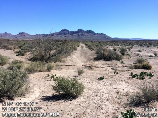
10 Section 2: Documentation of Wilderness Characteristics The northern extent of the Javelina Peak Proposed Lands with Wilderness Characteristics is rolling tobosa grassland and low shrub/scrub that spreads into the isolated Whitlock Valley, bordered by the distant Peloncillo Mountains. The canyon seen here features a series of rock and mortar dams that have been identified by BLM as having a negligible effect on wilderness character. We agree that these antiquated structures have no detrimental effect on the areas natural character, as they are not visible from this vantage just a few hundred feet away. Outstanding mule deer hunting can be had in this undulating terrain, highlighting the importance of maintaining the units wild character. Arizona Wilderness Coalition 10 ww.azwild.org
11 Size Criteria The Javelina Peak Proposed Lands with Wilderness Characteristics meets the minimum size criteria specified in BLM Manual 6310 with approximately 17,851 acres of contiguous, roadless land under BLM ownership. There is one undeveloped 40 acre private inholding contained within the LWC unit boundary which is not accessed by a wilderness inventory road (see points which document the condition of routes that lead to this parcel). Naturalness The proposed LWC is striking in its natural beauty and features an extensive core of wild terrain that is largely undisturbed by human impacts. This unit is surely dominated by the forces of nature, and undeniably appears natural to average visitors to this area. There are relatively few primitive routes permeating its boundaries, and no cherrystems. The primitive routes that do enter the proposed unit receive fairly low use, and do not cut deeply into the core of the LWC. Documented human impacts include several old, low-profile rock dams, some small dirt water tanks, some antiquated wildlife water catchments, and a few primitive routes. Substantial human impacts, including the Hot Well Dunes motorized recreation area, a powerline, and maintained roads have been excluded from the proposed LWC with clear, simple, and well-defined unit boundaries. Few primitive routes, or ways, are located within the LWC unit boundaries. These ways are generally short and do not penetrate into the heart of the unit. Most of the existing primitive routes were not constructed and appear to be user-created (points 2, 20-23, 26, 27 & 38), and/or have revegetated and been reclaimed by natural processes (points 3-5, 7, 29, 30, 31 & 33). The remainder of these unmaintained ways appear to receive very low amounts of vehicular use (points 12, 14, 17, 32, 34-36). The presence of these primitive routes within the proposed LWC does not substantially affect the naturalness of the area within because, as discussed above, many of these routes are barely visible. Human impacts included within the Javelina Peak Proposed LWC unit are minor and do not affect the naturalness of the unit as a whole. These impacts include fences, several small dams, earth-bermed water tanks, and two wildlife water catchments. Fencing is listed in BLM Manual 6310 as a human impact that can be considered substantially unnoticeable, and the amount of fencing in the unit is relatively minimal. The small rock and mortar dams can be seen in points 13, 15 and 17. As point 18 demonstrates, these relatively small impacts are hardly noticeable when viewed from only a short distance away. Many of the dams have been breached and no longer retain water. Additionally, the BLM determined in their 1987 EIS that these dams have little impact on naturalness (BLM, 1987) and were therefore included in the All Wilderness option of that EIS. Furthermore, small dams such as these can be found in existing Wilderness areas; setting the precedent that such structures do not significantly impact qualities of naturalness. Points 9 and 10 display images of a wildlife water catchment that is apparently out of order. Point 8 reveals that this infrastructure is virtually indistinguishable from a nearby vantage point. If indeed this water catchment is non-operational, it is our recommendation that the components be removed and the site rehabilitated. Another similar Arizona Wilderness Coalition 11 ww.azwild.org

12 catchment is located a short distance from point 5, and is hardly visible from the surrounding area. Again, there are other examples of wildlife water catchments in current Wilderness areas, reinforcing that such sites may be accommodated in LWCs. Other minor human disturbances contained within the proposed LWC are earth-bermed water tanks. BLM Manual 6310 lists earthbermed tanks among the human impacts that can be considered substantially unnoticeable to the average visitor, and thus do not detract from naturalness. As our photopoints document, the Javelina Peak Proposed LWC has sufficient topographic and vegetative screening throughout to render the relatively minor impacts discussed above unnoticeable. The Hot Well Dunes Recreation Area is located to the southwest of the proposed LWC unit. A portion of this area was included in the Javelina Peak Wilderness Study Area. This LWC proposal excludes the entire Hot Well Dunes Recreation Area with the LWC unit boundary following a fence line that encloses the recreation area. BLM Manual 6310 states that, Human impacts outside the area will not normally be considered in assessing naturalness of an area. During our inventory, we did not encounter or observe any OHVs in the recreation area. In addition, the proposed LWC contains abundant topographic relief and vegetative screening to mask backcountry users from detecting the presence of OHVs in the recreation area. The proposed LWC is dominated by the forces of nature, not man s influences. As we have discussed above, few minor human disturbances can be found within the unit. Those that do exist are generally located at the periphery of the unit and do not detract from the high degree of naturalness throughout the unit. No significant human impacts are located within the core. Ample topographic screening helps to camouflage the impacts of the minor disturbances that do exist. This wild and very scenic unit is largely untouched by human impacts, and as such, appears to exist in a very natural state to the average visitor. A view into the rugged and pristine heart of the unit from the western powerline boundary road, across washes and rolling ridgelines towards Javelina Peak nearly three miles in the distance. The sights and sounds of the Hot Well Dunes are nearly five miles from this location. Arizona Wilderness Coalition 12 ww.azwild.org

13 Solitude & Recreation The proposed LWC provides outstanding opportunities for solitude and primitive and unconfined recreation. Javelina Peak itself is unquestionably the tallest, most scenic and rugged mountain in the entire Whitlock Mountain Range. The LWC unit not only contains the entirety of Javelina Peak, but also includes an area of colorful badlands, natural sand dunes, numerous canyons, and plenty of stunning land to find solitude and to engage in primitive forms of recreation. High-quality solitude can be found throughout the proposed LWC. The rolling lowlands of the San Simon Valley offer plenty of topographic relief to find seclusion among desert vegetation, including cholla, prickly-pear, wolfberry, yucca, creosote, catclaw, Mormon tea, mesquite and more. As visitors climb from the valley floor at about 3,300 feet above sea level, up the steeply sloped Javelina Peak topping out at almost 5,600 feet elevation, there are numerous outstanding opportunities for finding solitude and adventure. Varied topography, including numerous desert washes, rolling hills, highly eroded badlands and the mountainous topography of Javelina Peak combine to provide outstanding opportunities for solitude. This same topographic diversity enhances a variety of primitive recreational uses including hiking, horseback riding, rock collecting, rock scrambling, camping and sightseeing (BLM, 1987: p. 132). The size, shape and topography of Javelina Peak WSA provide outstanding opportunities for solitude. Several canyons in the Whitlock Mountains, rolling hills and highly eroded badlands at the base of these mountains and numerous lowland washes combine to offer opportunities for isolation. The high points in the WSA offer excellent views of the surrounding undeveloped countryside and add to the feeling of isolation (BLM, 1987: p. 62). Arizona Wilderness Coalition 13 ww.azwild.org
14 The BLM itself has recognized the outstanding potential for primitive recreation within the proposed LWC, stating that the Javelina Peak WSA offers outstanding opportunities for such primitive recreation as hiking, horseback riding, rock collecting, rock scrambling, camping, photography and sightseeing. Topographic diversity greatly enhances many of these activities (BLM, 1987 Wilderness EIS: p. 62). Indeed, outstanding hiking, backpacking and horsepacking options are present within the Javelina Peak Proposed LWC today, as they were in The terrain in the units western lowlands is ideal for horseback riders seeking to travel cross country through the badlands or among the sand dunes that are not enclosed by the Hot Well Dunes recreation area. Javelina Peak is absolutely unique with its striking, extensive cliff bands and simply being on or around this mountain transforms ordinary primitive recreational experiences into outstanding ones, where hikers and backpackers will find outstanding prospects for navigating challenging terrain. This prominent mountain provides opportunities for extremely challenging ascents, rewarding climbers with exposed summits and expansive views, where rock climbers can explore a number of rugged vertical cliffs with outstanding opportunities for those looking for an out-of-the-ordinary climbing experience. Exceptional backcountry hunting opportunities can be found within the proposed LWC. Wildlife species of economic and recreational importance include band-tailed pigeon, Gambel s quail, javelina, scaled quail, mountain lion, mule deer, and white-winged dove ( The Whitlock Mountain Range has a high concentration of species of economic and recreational importance, especially when compared to other areas of the state. A significant portion of the proposed LWC provides habitat for species not found in the surrounding low-elevation desert such as javelina, scaled quail, and mule deer. It is of the utmost importance that public hunting areas with the most species of economic and recreational importance, such as the Javelina Peak Proposed LWC, be protected in order to ensure this vital form of primitive recreation can continue for generations to come. The proposed LWC unit provides remarkable options for nature study as well. As the photographs in this report attest, nature photographers are presented with a spectacular landscape with a variety of stark settings to photograph. Rock collectors and others interested in geologic features are sure to find many interesting formations to study, including areas with fossils. Those sightseeing for botanical or zoological features will also find a number of unique and noteworthy habitats to explore. Outstanding birdwatching prospects exist in the proposed LWC. Javelina Peak is flanked by a profusion of vertical volcanic cliffs that provide the perfect habitat for a variety of uncommon raptors. Indeed, Peregrine falcons are known to live among these extensive cliff bands. With such great elevational relief, a diversity of birds can be observed in a variety of ecosystems within the LWC unit. Whether a person wants to explore the unit s lowlands or uplands, they re sure to have an outstanding time studying nature s wonders on this magnificent piece of public land. In the 1987 Wilderness EIS, the BLM concluded that the OHV area (currently the Hot Well Dunes Recreation Area) negatively affected opportunities for solitude within the Javelina Peak WSA, stating that without Wilderness designation: Arizona Wilderness Coalition 14 ww.azwild.org
.")
15 Off-road vehicle use of the dunes in the southern part of the WSA would continue, resulting in impacts to opportunities for solitude and primitive recreation. While ORVs are using the area, it would be difficult to find and experience solitude. As ORV use continues to increase, so would impacts to the natural qualities of the WSA (BLM, 1987: p. 132). While these statements may have made sense at the time, this line of reasoning is fundamentally flawed regarding impacts to solitude when considering the guidelines laid out in BLM Manual 6310, which states that LWC inventory should Only consider the impacts of sights and sounds from outside the inventory area on the opportunity for solitude if these impacts are pervasive and omnipresent. Pervasive means existing in every part of something or spreading to every part of something, and omnipresent means present in all places at all times. Our inventory team did not see any ORV users within the Hot Well Dunes Recreation Area during either of our two inventory trips (January and March, 2016). The recreation area most likely receives almost all of its visitors during the spring and autumn when the weather and ground conditions are best. This means that virtually no one is around for the other half of the year. The sights and sounds from the Hot Well Dunes Recreation Area therefore cannot be considered pervasive and omnipresent, and therefore should not be considered detrimental to opportunities for solitude that are found within the proposed LWC. Additionally, the entire northern half of the LWC unit is far from the recreation area and has a tremendous amount of rugged terrain blocking all sights and sounds of the recreation area. This view into the Javelina Peak Proposed Lands with Wilderness Characteristics is from the northern tip of the Hot Well Dunes Recreation Area, a popular motorized recreation area where users drive over hundreds of acres of sand dunes. Most users stay within the fenced area, though we discovered two locations where some users cross breaks in the fence. The remaining dunes, badlands, and sprawling desert flats are sensitive areas where there should be no off-road vehicle travel. Protection of these fragile formations from off-road vehicles could be achieved through management for the protection of wilderness characteristics. The proposed LWC features a truly impressive expanse of desert terrain that is deserving of this level of protection and enhanced management. Arizona Wilderness Coalition 15 ww.azwild.org
16 Conclusion The Arizona Wilderness Coalition recommends to the Bureau of Land Management that the proposed area should be managed for protection of wilderness characteristics according to the policies established in BLM Manuals 6310 and In this report, we have provided the requirements for a citizens proposal, and documented that the proposed unit meets the criteria for size, naturalness, solitude, and primitive and unconfined recreation. The landscape within the proposed LWC unit is ideal for experiencing outstanding solitude. The heavily featured badlands at the western base of Javelina Peak, as well as unique sand dunes, and various drainages and basins all over the mountain, provide countless locations to be alone in a wilderness-like setting. It is especially easy to find solitude in the secluded northeastern part of the proposed LWC in the eastern slopes of the Whitlock Mountains adjacent to the isolated and largely undeveloped Whitlock Valley. Outstanding solitude can also be found at the rarely summited top of Javelina Peak where one can gaze out across an expansive landscape in a remote region with few signs of civilization present for many miles. The Javelina Peak proposed LWC provides outstanding opportunities to pursue primitive and unconfined recreation. Backcountry visitors can choose from many different forms of recreation, and with almost 18,000 acres to explore, they will most certainly find solitude as well. The dramatic landscape with expansive views and over 2,300 feet of elevational relief transforms ordinary recreational activities into outstanding experiences creating memories that may last a lifetime. The BLM stated in their 1987 Wilderness EIS that, The natural qualities of the area not recommended for wilderness would show increasing signs of ORV use. Indeed, today this is the case; points 26 and 27 document the illegal cutting of fencing meant to keep ORV users within the Hot Well Dunes Recreation Area. The Javelina Peak unit needs to be managed as an LWC in order to prevent further degradation of the wilderness quality lands including unique sand dunes, sensitive natural areas, and desert vegetation. Protection of these wilderness characteristics is essential to preserving the natural values present throughout the unit. Arizona Wilderness Coalition has previously stated that: If this area is not protected by wilderness status, the ecologically significant southern end would face a significant increase in ORV use. This would have an extremely detrimental effect on both the land and the wildlife. Moreover, since fossils have been found in the badlands, increased ORV use could have an adverse impact on undiscovered sites (AWC, 1987: p. 193). Since that time, the area now managed for motorized recreation has lost its wilderness characteristics. We strongly believe that the BLM must not sacrifice any more of this special, wild landscape to off-road recreation. Management for preservation of wilderness characteristics is needed at Javelina Peak. Works Cited: AWC Arizona Wilderness: A proposal prepared by the Arizona Wilderness Coalition, December, BLM Safford District Final Environmental Impact Statement: Proposed Wilderness Program for the Safford District Wilderness EIS Area. Department of the Interior, Bureau of Land Management, Safford District, Arizona. Arizona Wilderness Coalition 16 ww.azwild.org
17 Section 3: Detailed Description of the Unit Boundary, Roads, Ways and Human Impacts Narrative Description of the Proposed LWC Boundary & Vehicle Routes Segment A: Northwest Boundary - Powerline General Description: The northwestern boundary of the Javelina Peak Proposed LWC is a powerline and an unnamed powerline access road (point 1). Ways: -Point 2 shows an image of a short user-created primitive route that is kept open solely by the passage of vehicles. As the photo illustrates, this way minimally affects naturalness, and would naturally revegetate if vehicle use were terminated. -Point 3 displays a photograph of an old way that was once used to access a water tank, but has since revegetated and been reclaimed by nature. Point 4 provides further evidence that this old primitive route has naturalized. -Point 5 was taken looking southeast down another old vehicle way that has been reclaimed by natural processes and can no longer be negotiated by a vehicle. Segment B: Northeast Boundary General Description: The northeastern unit boundary is comprised of the BLM property line with State Trust Land, as well as a wilderness inventory road seen in points 6 and 11. Point 16 was taken at the northeastern unit boundary from Badger Well Den Road looking west down a fence line that runs along the BLM property line (unit boundary). Boundary Adjustments: An earth-bermed tank just to the west of point 7 and directly along the boundary road is excluded from the proposed LWC because it is likely to be mechanically maintained. Ways: use. -Point 7 shows a reclaimed way that has naturally revegetated and no longer receives vehicular -Points 12 and 14 depict an unmaintained primitive route that leads to a series of small dams (points 13 & 15). These dams were analyzed during the initial wilderness inventory and BLM determined that they did not substantially affect the naturalness of the unit. Associated Human Impacts: -Points 8, 9, and 10 document an old wildlife water catchment that appears to be nonfunctional. Point 8 illustrates that this water catchment is substantially unnoticeable across the landscape. Arizona Wilderness Coalition 17 ww.azwild.org
18 -Points 13 and 15 show two small dam structures that do not substantially affect the naturalness of the area. As point 15 displays, the upper dam has been breached and is no longer effective. Segment C: Southeast Boundary Badger Den Well Road & Hot Well Dunes Recreation Area General Description: This boundary consists of a maintained road called Badger Den Well Road (points 19 & 24). From the cattle guard seen in point 24, the LWC unit boundary turns to the north and follows a fence line (point 25) that delineates the boundary of the Hot Well Dunes Recreation Area. The fence line (Hot Well Dunes Recreation Area boundary) continues to serve as the proposed unit boundary until it intercepts Haekel Road. Point 28 (taken outside of the proposed LWC unit) shows the Hot Well Dunes Recreation Area, and Haekel Road (left) and Badger Den Well Road (right), which further down each road becomes the southwestern and southeastern unit boundaries, respectively. Ways: -Point 17 shows a primitive route with no evidence of maintenance that leads to an old dam at Dripping Springs. -Point 20 was taken looking north up a user-created way. This primitive route is not maintained and ends where vegetation restricts vehicle passage just a short distance up the wash. -Point 21 depicts another user-created way that slowly fades as it travels away from the boundary road. This primitive route is kept open solely by the passage of vehicles and does not substantially affect naturalness. -Point 22 shows a faint primitive route that is kept open solely by the passage of vehicles. Point 23 displays an image of this route near its terminus. -Points 26 and 27 document two locations where the fence that delineates the boundary of the Hot Well Dunes Recreation Area was cut, and off-highway vehicles were used to create two primitive routes that enter the proposed LWC unit. As stated above, these are user-created ways that have never been mechanically maintained. It is our recommendation that the fence line be mended to keep the motorized vehicle use within the recreation area. Associated Human Impacts: -Points 17 and 18 show images of an old dam at Dripping Springs that was built by the Civilian Conservation Core. The reservoir is dry behind the dam and the metal pipe leading to a water tank is broken allowing water to drain into the creek. As these photographs depict, this human impact is substantially unnoticeable to the average visitor and does not detract from naturalness. Segment D: Southwest Boundary General Description: Haekel Road is a chip-sealed secondary road that forms most of the southwestern unit boundary of the proposed LWC. There is a small parcel of private land along Haekel Road where the LWC boundary follows the BLM property line around the private parcel. Ways: Arizona Wilderness Coalition 18 ww.azwild.org
19 -Point 29 shows an old vehicle way with no apparent purpose that has naturally revegetated and been reclaimed by nature. There was no evidence of vehicular use at the time of our inventory. -Points 30 and 31 display images of a reclaimed way in a natural wash that is listed in the BLM s route inventory. Our inventory team found no evidence of such a route and the wash showed no signs of vehicular use. -Point 32 was taken from Haekel Road on private land looking toward the proposed LWC unit. This point documents a rarely used way that leads to an earth-bermed tank on BLM land. -Point 33 (also taken from Haekel Road on private land) depicts an old way that has been closed to vehicles. Points show images of this same way farther to the east where it apparently does receive vehicular use, albeit very infrequently. This primitive route leads to an old corral that appears to be defunct (point 37) and an earth-bermed tank (KMP tank). As points display, this way is revegetating and does not detract from the naturalness of the area. -Point 38 was taken from the unit boundary looking to the northeast up a natural wash that receives some vehicular use. This wash contains no evidence of construction or maintenance. Associated Human Impacts: -Point 37 documents the unmaintained condition of a corral near KMP tank. Arizona Wilderness Coalition 19 ww.azwild.org


20 Section 4: Photopoint Data Point 1 Route name Utility ROW/Access Construction Bladed & Cut and Fill 4-WD trucks Purpose Utility access/row Maintenance Likely if needed Determination Road Feature Junction of Routes/Ways Unit Boundary 001 Point 2 ATV and/or Dirtbike Purpose No apparent purpose Determination Way Feature Low use Feature minimally affects naturalness Kept open solely by passage of vehicles Point 3 None Purpose Earthenbermed tank Determination Reclaimed Feature Revegetated Arizona Wilderness Coalition 20 ww.azwild.org


21 Point 4 4-WD trucks Purpose Earthenbermed tank Determination Reclaimed Typical Feature Condition of Route/Way Feature minimally affects naturalness Point 5 None Purpose No apparent purpose Determination Reclaimed Feature Revegetated Point 006 Construction Bladed & Cut and Fill 4-WD Trucks Purpose Wildlife Water Catchment Maintenance Old evidence years ago Determination Road Typical Feature Condition of Route/Way Unit Boundary 006 Arizona Wilderness Coalition 21 ww.azwild.org


22 Point 7 Construction Bladed & Cut and Fill None Purpose None Determination Reclaimed Feature Revegetating 007 Point 8 Route name N/A Construction N/A N/A Purpose N/A Maintenance N/A Determination N/A Over view of Feature water catchment Substantially unnoticeable 008 Point 9 Route name N/A Construction N/A None apparent Purpose N/A Maintenance N/A Determination N/A Feature Water trough - no H2O No water available, no water when pipe turned on=empty tank No access route, seems abandoned 009 Arizona Wilderness Coalition 22 ww.azwild.org


23 Point 10 Route name N/A Construction N/A N/A Purpose Old water catchment apparent Determination N/A Feature Wildlife Water Catchment Tarp is grown through by brush, corrugated metal leads to underground tank Appears nonoperational Point 11 Construction Bladed 4-WD Trucks Purpose Wildlife water Maintenance Old evidence years ago Determination Road Typical Feature Condition of Route/Way Unit Boundary Point 12 Construction Bladed 4-WD trucks Purpose Dam developments Maintenance No evidence Determination Way Typical Feature Condition of Route/Way <None> 012 Arizona Wilderness Coalition 23 ww.azwild.org


24 Point 13 Route name N/A Construction Concrete/stone dam N/A Purpose N/A Maintenance Periodic Determination N/A Feature Dam <None> 013 Point 14 ATV and/or Dirtbike - very rare Purpose Dams Determination Way Typical Feature Condition of Route/Way Feature minimally affects naturalness Point 15 Route name N/A Construction Stone dam N/A Purpose Dam Determination N/A Feature Stone dam Feature minimally affects naturalness Interesting historical structure Arizona Wilderness Coalition 24 ww.azwild.org


25 Point 16 Route name N/A Construction N/A N/A Purpose N/A Maintenance N/A Determination N/A Feature Fence line Unit Boundary 016 Point 17 Construction Probably only bladed once 4-WD trucks Purpose Small Concrete Dam Determination Way Typical Feature Condition of Route/Way Dripping Springs Access Dry behind dam, metal pipe to tank is broken allowing water to drain into creek Point 18 Route name N/A Construction Dam None apparent Purpose None apparent apparent Determination N/A Feature Dam Substantially unnoticeable Minor impact Arizona Wilderness Coalition 25 ww.azwild.org


26 Point 19 Route name Badger Den Well Road Construction Bladed 2-WD Passenger vehicle Purpose Well/Water tanks Semi-recent Maintenance evidence years ago Determination Road Feature Windmill Road to dilapidated windmill, rotted fencing Unit Boundary Point 20 4-WD trucks Purpose Recreation Determination Way Typical Feature Condition of Route/Way Kept open soley by passage of vehicles Vegetation restricts vehicle passage short distance up wash Point 21 ATV and/or Dirtbike Purpose Recreation Determination Way Typical Feature Condition of Route/Way Feature minimally affects naturalness Kept open solely by passage of vehicles Arizona Wilderness Coalition 26 ww.azwild.org


27 Point 22 ATV and/or Dirtbike Purpose Recreation Determination Way Typical Feature Condition of Route/Way Kept open solely by passage of vehicles Point 23 ATV and/or Dirtbike Purpose Recreation Determination Way Feature End of Way Way ends before drop off Kept open solely by vehicle passage Point 24 Route name Badger Den Well Road Construction Bladed 2-WD Passenger vehicle Purpose Multiple uses Very recent Maintenance blade - past year Determination Road Typical Feature Condition of Route/Way Cattleguard in foreground Possible boundary of the ATV play area 024 Arizona Wilderness Coalition 27 ww.azwild.org


28 Point 25 Route name N/A Construction N/A N/A Boundary of Purpose Hot Well Dunes Rec. Area Determination Fence line/unit boundary Feature Fence line Unit Boundary 025 Point 26 ATV and/or Dirtbike Purpose No apparent purpose Determination Way Feature Fence cut illegally Fence should be repaired Kept open solely by passage of vehicles Point 27 ATV and/or Dirtbike Purpose Recreation Determination Way Feature Cut Fence Fence needs repair Fence cut with bolt/wire cutters to open surrounding desert area to ATV play area Arizona Wilderness Coalition 28 ww.azwild.org


29 Point 28 Junction of Route name Haekel Rd & eastern boundary rd Construction Chip Seal 2-WD Passenger vehicle Purpose Multiple uses Maintenance Recent maintenance Determination Road Feature Junction of Routes/Ways Photo taken outside of LWC unit Unit Boundaries Point 29 None Purpose No apparent purpose Determination Reclaimed Feature Revegetated Point 30 None Purpose None apparent Determination Reclaimed Feature Revegetated Feature minimally affects naturalness 030 Arizona Wilderness Coalition 29 ww.azwild.org


30 Point 31 None Purpose None apparent Determination Natural Wash Feature Natural Wash 031 Point 32 4-WD trucks Purpose Earthenbermed tank Determination Way Typical Feature Condition of Route/Way Feature minimally affects naturalness Point 33 None Purpose KMP tank Determination Reclaimed Feature Revegetated Feature minimally affects naturalness Way closed to vehicles Arizona Wilderness Coalition 30 ww.azwild.org


31 Point 34 4-WD Trucks Purpose Old corral Determination Way Typical Feature Condition of Route/Way Revegetating 034 Point 35 4-WD Trucks Purpose Old corral Determination Way Typical Feature Condition of Route/Way Kept open solely by vehicle passage 035 Point 36 4-WD Trucks Purpose Earth-bermed tank/corral Determination Way Typical Feature Condition of Route/Way Obvious lack of maintenance 036 Arizona Wilderness Coalition 31 ww.azwild.org


32 Point 37 Route name N/A Construction N/A None apparent Purpose N/A Maintenance N/A Determination N/A Feature orral One side of corral is missing wiring - potentially abandoned Shrubs growing in loading ramp, busted gate, missing fence line Point 38 Off Road Vehicles Purpose No apparent purpose Determination Way Feature Natural Wash Low use probable Arizona Wilderness Coalition 32 ww.azwild.org
A proposal report to the Bureau of Land Management, Safford Field Office, Arizona. October, 2016
 PELONCILLO MOUNTAINS LANDS WITH WILDERNESS CHARACTERISTICS THREE UNITS OF PUBLIC LAND CONTIGUOUS TO THE NORTHERN BOUNDARY OF THE PELONCILLO MOUNTAINS WILDERNESS, ARIZONA: WHITEHORSE, ANTELOPE CANYON AND
Proposed Lands With Wilderness Characteristics: HOVERROCKER Public Lands in Greenlee County, Arizona
 Proposed Lands With Wilderness Characteristics: HOVERROCKER Public Lands in Greenlee County, Arizona A proposal report to the Bureau of Land Management, Safford Field Office, Arizona February, 2018 Prepared
Proposed Lands With Wilderness Characteristics: STEWART CANYON. Public Lands in Greenlee County, Arizona
 Proposed Lands With Wilderness Characteristics: STEWART CANYON Public Lands in Greenlee County, Arizona A proposal report to the Bureau of Land Management, Safford Field Office, Arizona February, 2018
Dry Mountain Public Lands in Graham County, AZ Managed by the BLM Safford Field Office
 Proposed Lands With Wilderness Characteristics: Dry Mountain Public Lands in Graham County, AZ Managed by the BLM Safford Field Office A proposal report to the Bureau of Land Management, Safford Field
/s/ Robert V. Abbey Director
 Form 1221-2 (June 1969) UNITED STATES DEPARTMENT OF THE INTERIOR BUREAU OF LAND MANAGEMENT MANUAL TRANSMITTAL SHEET Release 6-129 Date 03/15/2012 Subject 6310 Conducting Wilderness Characteristics Inventory
DOS CABEZAS MOUNTAINS
 DOS CABEZAS MOUNTAINS LANDS WITH WILDERNESS CHARACTERISTICS PUBLIC LANDS CONTIGUOUS TO THE BLM S DOS CABEZAS MOUNTAINS WILDERNESS IN THE NORTHERN CHIRICAHUA MOUNTAINS, ARIZONA A proposal report to the
Proposed Lands With Wilderness Characteristics: Gila Box Public Lands in Graham and Greenlee Counties, Arizona
 Proposed Lands With Wilderness Characteristics: Gila Box Public Lands in Graham and Greenlee Counties, Arizona A proposal report to the Bureau of Land Management, Safford Field Office, Arizona March, 2018
WORKSHEET 1 Wilderness Qualities or Attributes Evaluating the Effects of Project Activities on Wilderness Attributes
 WORKSHEET 1 Wilderness Qualities or Attributes Evaluating the Effects of Project Activities on Wilderness Attributes Date: 3/7/2017 Roadless Area: Ruby South Description of Project Activity or Impact to
Connie Rudd Superintendent, Black Canyon of the Gunnison National Park
 National Park Service U.S. Department of the Interior Black Canyon of the Gunnison National Park and Curecanti National Recreation Area Information Brochure #1 Wilderness and Backcountry Management Plan
EMERY COUNTY PUBLIC LAND MANAGEMENT ACT OF 2018 S. 2809/H.R. 5727
 EMERY COUNTY PUBLIC LAND MANAGEMENT ACT OF 2018 S. 2809/H.R. 5727 September 25, 2018 OVERVIEW The Emery County Public Land Management Act of 2018 is a significant step backwards for wilderness and conservation
Dean Peak. March 2018 Prepared by: James Holderer. Proposed Lands with Wilderness Characteristics. Public Lands in the Hualapai Mountains
 Proposed Lands with Wilderness Characteristics Dean Peak Public Lands in the Hualapai Mountains A proposal report to the Bureau of Land Management, Kingman Field Office, Arizona March 2018 Prepared by:
April 10, Mark Stiles San Juan Public Lands Center Manager 15 Burnett Court Durango, CO Dear Mark,
 Mark Stiles San Juan Public Lands Center Manager 15 Burnett Court Durango, CO 81301 Dear Mark, We are pleased to offer the following comments on the draft San Juan Public Lands Center management plans
Arthur Carhart National Wilderness Training Center s Wilderness Investigations High School
 Arthur Carhart National Training Center s Investigations High School 101/Lesson 2 (OPTION 2B) Introducing the Act Goal: Students will understand the difference between wild spaces and federally designated
Continental Divide National Scenic Trail Legislative History and Planning Guidance
 Continental Divide National Scenic Trail Legislative History and Planning Guidance Legislation, Policy, and Direction Regarding National Scenic Trails The National Trails System Act, P.L. 90-543, was passed
Recreation Opportunity Spectrum for River Management v
 Recreation Opportunity Spectrum for Management v. 120803 Introduction The following Recreation Opportunity Spectrum (ROS) characterizations and matrices mirror the presentation in the ROS Primer and Field
5.0 OUTDOOR RECREATION OPPORTUNITIES AND MANAGEMENT
 5.0 OUTDOOR RECREATION OPPORTUNITIES AND MANAGEMENT 5.1 Introduction This section describes the range of recreational activities that currently take place in Marble Range and Edge Hills Parks, as well
Susitna-Watana Hydroelectric Project (FERC No ) Recreation Resources Study Study Plan Section Study Implementation Report
 Recreation Resources Study Study Plan Section Study Implementation Report") (FERC No. 14241) Recreation Resources Study Study Plan Section 12.5 2014 Study Implementation Report Prepared for Prepared by AECOM November 2015 TABLE OF CONTENTS 1. Introduction... 4 2. Study Objectives...
(FERC No. 14241) Recreation Resources Study Study Plan Section 12.5 2014 Study Implementation Report Prepared for Prepared by AECOM November 2015 TABLE OF CONTENTS 1. Introduction... 4 2. Study Objectives...
Final Recreation Report. Sunflower Allotment Grazing Analysis. July 2015
 Final Recreation Report Sunflower Allotment Grazing Analysis July 2015 Table of Contents Introduction... 3 Affected Environment... 3 Four Peaks Wilderness Area... 3 Dispersed Recreation... 3 Environmental
WILDERNESS PLANNING. Wilderness. Interagency Regional Wilderness Stewardship Training. Alamosa, Colorado - March 26-29, 2007
 WILDERNESS PLANNING Interagency Regional Wilderness Stewardship Training Alamosa, Colorado - March 26-29, 2007 Suzanne Stutzman Lead Planner/Wilderness Coordinator National Park Service, Intermountain
United States Department of the Interior National Park Service. Boundary Expansion Listed in National Register January 11, 2017
 NPS Form 10900-a (Rev. 8/2002) OMB No. 10240018 United States Department of the Interior National Park Service Boundary Expansion Listed in National Register January 11, 2017 National Register of Historic
RE: Access Fund Comments on Yosemite National Park Wilderness Stewardship Plan, Preliminary Ideas and Concepts
 September 30, 2016 Superintendent Yosemite National Park Attn: Wilderness Stewardship Plan P.O. Box 577 Yosemite, CA 95389 RE: Access Fund Comments on Yosemite National Park Wilderness Stewardship Plan,
Appendix I. Wilderness Review
 Appendix I. Wilderness Review This appendix contains the wilderness inventory conducted for the Ash Meadows, Moapa Valley, and Pahranagat National Wildlife Refuges (NWRs) as part of the Comprehensive Conservation
Special Recreation Management Areas Extensive Recreation Management Areas Public Lands Not Designated as Recreation Management Areas
 From the Proposed RMP: Special Recreation Management Areas SRMAs are an administrative unit where the existing or proposed recreation opportunities and recreation setting characteristics are recognized
FINAL TESTIMONY 1 COMMITTEE ON RESOURCES UNITED STATES HOUSE OF REPRESENTATIVES. July 13, 2005 CONCERNING. Motorized Recreational Use of Federal Lands
 FINAL TESTIMONY 1 STATEMENT OF DALE BOSWORTH CHIEF Of the FOREST SERVICE UNITED STATES DEPARTMENT OF AGRICULTURE Before the SUBCOMMITTEE ON FORESTS AND FOREST HEALTH And the SUBCOMMITTEE ON NATIONAL PARKS,
A GIS Analysis of Probable High Recreation Use Areas in Three Sisters Wilderness Deschutes and Willamette National Forests
 Lindsey Kiesz Geo 565 Term Project 3/15/2010 A GIS Analysis of Probable High Recreation Use Areas in Three Sisters Wilderness Deschutes and Willamette National Forests Introduction The Three Sisters Wilderness
Ribbon Cliff - Ribbon Mesa text and photos by Charlie Hickenbottom
 Ribbon Cliff - Ribbon Mesa text and photos by Charlie Hickenbottom Looking for something a little different than Sage Hills or Saddlerock? Perhaps something a little wilder, a little less traveled? Look
Sawtooth National Forest Fairfield Ranger District
 United States Department of Agriculture Forest Service Sawtooth National Forest Fairfield Ranger District P.O. Box 189 Fairfield, ID. 83327 208-764-3202 Fax: 208-764-3211 File Code: 1950/7700 Date: December
Photopoint Monitoring in the Adirondack Alpine Zone
 Photopoint Monitoring in the Adirondack Alpine Zone Julia Goren (PI) and Seth Jones Adirondack High Peaks Summit Steward Program Adirondack Mountain Club summit@adk.org PO Box 867, Lake Placid, NY 12946
Proposed Lands with Wilderness Characteristics: Black Mesa. A proposal report to the Bureau of Land Management, Kingman Field Office, Arizona
 Proposed Lands with Wilderness Characteristics: A proposal report to the Bureau of Land Management, Kingman Field Office, Arizona August, 2015 Prepared by: Joseph M. Trudeau & Amber R. Fields Table of
Theme: Predominately natural/natural appearing; rustic improvements to protect resources. Size*: 2,500 + acres Infrastructure**:
 Recreation Opportunity Spectrum (ROS) Classes The Recreation Opportunity Spectrum (ROS) provides a way to describe the variations in the degree of isolation from the sounds and influences of people, and
Preferred Recreation Recommendations Stemilt-Squilchuck Recreation Plan March 2018
 Preferred Recreation Recommendations Stemilt-Squilchuck Recreation Plan March 2018 Below are the recommended recreation ideas and strategies that package together the various recreation concepts compiled
Wilderness Research. in Alaska s National Parks. Scientists: Heading to the Alaska Wilderness? Introduction
 Wilderness Research in Alaska s National Parks National Park Service U.S. Department of Interior Scientists: Heading to the Alaska Wilderness? Archeologist conducts fieldwork in Gates of the Arctic National
Appendix A BC Provincial Parks System Goals
 Appendix A BC Provincial Parks System Goals The British Columbia Provincial Parks System has two mandates: To conserve significant and representative natural and cultural resources To provide a wide variety
Rule Governing the Designation and Establishment of All-Terrain Vehicle Use Trails on State Land
 Rule Governing the Designation and Establishment of All-Terrain Vehicle Use Trails on State Land 1.0 Authority 1.1 This rule is promulgated pursuant to 23 V.S.A. 3506. Section 3506 (b)(4) states that an
RECREATION. Seven issues were identified that pertain to the effects of travel management on outdoor recreation within portions of the project area.
 RECREATION Seven issues were identified that pertain to the effects of travel management on outdoor recreation within portions of the project area. OPPORTUNITIES FOR SOLITUDE / QUIET TRAILS. One attraction
Arizona National Scenic Trail
 1 The Arizona National Scenic Trail is an 800 mile recreation trail from Mexico to Utah that connects mountain ranges, canyons, deserts, forests, wilderness areas, historic sites, trail systems, points
Wilderness Areas Designated by the White Pine County bill
 Wilderness Areas Designated by the White Pine County bill SEC. 321. SHORT TITLE. This subtitle may be cited as the `Pam White Wilderness Act of 2006'. SEC. 322. FINDINGS. Congress finds that-- The White
Dumont Dunes Special Recreation Management Area (SRMA)
") Dumont Dunes Special Recreation Management Area (SRMA) RMA/RECREATION MANAGEMENT ZONE (RMZ) OBJECTIVE(S) DECISIONS Objective Statement: Designate this area as a Special Recreation Management Area. To manage
Dumont Dunes Special Recreation Management Area (SRMA) RMA/RECREATION MANAGEMENT ZONE (RMZ) OBJECTIVE(S) DECISIONS Objective Statement: Designate this area as a Special Recreation Management Area. To manage
Creating a User-Driven Long-Distance OHV Trail Through Partnering
 Joseph Raffaele Outdoor Recreation Planner U.S. Bureau of Land Management Yuma, Arizona Creating a User-Driven Long-Distance OHV Trail Through Partnering BLM is a multiple-use land management agency within
(Short Listing) DUPUYER ACREAGE, ROCKY MOUNTAN FRONT
 DUPUYER ACREAGE, ROCKY MOUNTAN FRONT") (Short Listing) DUPUYER ACREAGE, ROCKY MOUNTAN FRONT This unique property is located 8½ miles northwest of Dupuyer, Montana and approximately thirty 30 miles northwest of Choteau, Montana. Great Falls
(Short Listing) DUPUYER ACREAGE, ROCKY MOUNTAN FRONT This unique property is located 8½ miles northwest of Dupuyer, Montana and approximately thirty 30 miles northwest of Choteau, Montana. Great Falls
LANDS WITH WILDERNESS CHACTERISTICS
 LANDS WITH WILDERNESS CHACTERISTICS A hiking guide for Ten BLM roadless areas inventoried by Wild Connections Each area description includes a summary of BLM s inventory for wilderness characteristics,
Overview. Wilderness Act of Statement of Need. What is Wilderness Character. Monitoring Wilderness Character
 Overview Monitoring Wilderness Character What What & Why? How? How? Conceptual Development How? How? Implementation Future? Future? Troy Hall Steve Boutcher USFS Wilderness & Wild and Scenic River Program
National Wilderness Steering Committee
 National Wilderness Steering Committee Guidance White Paper Number 1 Issue: Cultural Resources and Wilderness Date: November 30, 2002 Introduction to the Issue Two of the purposes of the National Wilderness
FEASIBILITY CRITERIA
 This chapter describes the methodology and criteria used to evaluate the feasibility of developing trails throughout the study areas. Land availability, habitat sensitivity, roadway crossings and on-street
Marchand Provincial Park. Management Plan
 Marchand Provincial Park Management Plan 2 Marchand Provincial Park Table of Contents 1. Introduction... 3 2. Park History... 3 3. Park Attributes... 4 3.1 Natural... 4 3.2 Recreational... 4 3.3 Additional
26 Utah s Patchwork Parkway SCENIC BYWAY CORRIDOR MANAGEMENT PLAN (SR 143)
") Natural Natural Quality applies to those features in the visual environment that are in a relatively undisturbed state. These features predate the arrival of human populations and may include geological
Natural Natural Quality applies to those features in the visual environment that are in a relatively undisturbed state. These features predate the arrival of human populations and may include geological
Big Sandy Ranch Mohave County, Arizona
 Big Sandy Ranch Mohave County, Arizona Photo [9] Deeded land on hillside within the River Ranch parcel Listed for sale exclusively by: Traegen Knight Headquarters West Ltd. PO BOX 1980 St. Johns, AZ 85936
Wilderness Character and Wilderness Characteristics. What s the difference? Why does it matter?
 Introduction Wilderness Character and Wilderness Characteristics What s the difference? Why does it matter? The terms wilderness character and wilderness characteristics are sometimes used interchangeably
Bayview Escarpment. Interim Management Statement
 Bayview Escarpment Interim Management Statement Bayview Escarpment Provincial Nature Reserve Interim Management Statement January 15, 1995 REGIONAL DIRECTOR'S APPROVAL STATEMENT This Interim Management
ANGEL PEAK SCENIC AREA
 Activities: Facilities: ANGEL PEAK SCENIC AREA Hiking, photography, watchable wildlife, camping, picnicking. Note: While formal hiking trails in the area are limited, dispersed hiking opportunities abound
Securing Permanent Protection for Public Land
 Securing Permanent Protection for Public Land Tools for Wyoming Advocates Paul Spitler* The Wilderness Society * I am a wilderness policy expert, not a powerpoint expert! Platform and Resolutions of the
Coconino National Forest Potential Wilderness Proposal
 Coconino National Forest Potential Wilderness Proposal As part of their Forest Plan Update, the Coconino National Forest needs to address the need for additional wilderness. The last evaluation was done
Wilderness Process #NP-1810: Your letter ID is NP September 5, 2018
 Wilderness Process #NP-1810: Your letter ID is NP-1810-2602-96 September 5, 2018 RE: GMUG Wilderness Evaluation Revised Evaluation Criteria and Draft Report Forest Revision Planning Team: The Continental
National Park Service Wilderness Action Plan
 National Park Service U.S. Department of the Interior National Park Service Wilderness Action Plan National Wilderness Steering Committee National Park Service "The mountains can be reached in all seasons.
Trail Phasing Plan. Note: Trails in the Clear Creek Canyon area (Segments will be finalized in the future to minimize wildlife impacts
 Note: Trails in the Clear Creek Canyon area (Segments 2 5 and a future JCOS connection) will be finalized in the future to minimize wildlife impacts Trail Phasing Plan P Parking 3 Easy Trail Intermediate
Federal Land and Resource Management: A Primer 1
 Federal Land and Resource Management: A Primer 1 RS20002 Coordinated by Ross W. Gorte Natural Resource Economist and Policy Specialist Environment and Natural Resources Policy Division December 22, 1998
French Fire Recovery and Restoration Project Wilderness Resource Impact Analysis
 French Fire Recovery and Restoration Project Wilderness Resource Impact Analysis This Wilderness Resource Impact Analysis for the French Recovery and Restoration Project (Project) includes a review of
2.0 PARK VISION AND ROLES
 2.0 PARK VISION AND ROLES 2.1 Significance in the Protected Area System Marble Range and Edge Hills provincial parks protect 6.8% of the Pavillion Ranges Ecosection, which is located in the Southern Interior
PROPOSED PARK ALTERNATIVES
 8 Chimne y Rock State Park M a ster Pl an 2011 PROPOSED PARK ALTERNATIVES Introduction Three different park development concepts were prepared and presented to the citizens of North Carolina through a
SEGMENT ASSESSMENT REPORT
 2017 SEGMENT ASSESSMENT REPORT SEGMENT 3: MT ROSE / TAHOE MEADOWS TO SPOONER SUMMIT REPORT SUMMARY This report is a compilation of information collected on the Tahoe Rim Trail during assessments performed
DECISION MEMO. Rawhide Trail #7073 Maintenance and Reconstruction
 Page 1 of 6 Background DECISION MEMO USDA Forest Service Jefferson Ranger District Jefferson County, Montana Rawhide Trail #7073 is located in the Elkhorn Mountain Range approximately 10 miles east of
Wilderness Stewardship Plan Scoping Newsletter Winter 2013
 Olympic National Park National Park Service U.S. Department of the Interior Wilderness Stewardship Plan Scoping Newsletter Winter 2013 Dear Friends and Neighbors, The Olympic Wilderness was established
Procedure for the Use of Power-Driven Mobility Devices on Mass Audubon Sanctuaries 1 September 17, 2012
 Procedure for the Use of Power-Driven Mobility Devices on Mass Audubon Sanctuaries 1 September 17, 2012 Background As part of Mass Audubon s mission to preserve the nature of Massachusetts for people and
Pinellas County Environmental Lands
 Pinellas County Environmental Lands In addition to traditional parks and recreation facilities, Pinellas County owns and manages a system of environmental lands that provides specialized resource-based
Labrador - Island Transmission Link Target Rare Plant Survey Locations
 27-28- Figure: 36 of 55 29-28- Figure: 37 of 55 29- Figure: 38 of 55 #* Figure: 39 of 55 30- - east side Figure: 40 of 55 31- Figure: 41 of 55 31- Figure: 42 of 55 32- - secondary Figure: 43 of 55 32-
As outlined in the Tatshenshini-Alsek Park Management Agreement, park management will:
 Management Strategy General Strategy The priority management focus for the park is to ensure that its internationally significant natural, cultural heritage and recreational values are protected and that
TONGASS NATIONAL FOREST
 TONGASS NATIONAL FOREST UNITED STATES DEPARTMENT OF AGRICULTURE-FOREST SERVICE Contact: Dennis Neill Phone: 907-228-6201 Release Date: May 17, 2002 SEIS Questions and Answers Q. Why did you prepare this
Lidar Imagery Reveals Maine's Land Surface in Unprecedented Detail
 Maine Geologic Facts and Localities December, 2011 Lidar Imagery Reveals Maine's Land Surface in Unprecedented Detail Text by Woodrow Thompson, Department of Agriculture, Conservation & Forestry 1 Introduction
Environmental Development of River Road Ranch
 Environmental Development of River Road Ranch New Braunfels, Texas Alix Scarborough GEO 3426 April 2012 Introduction The 2,400-acre Word-Borcher ranch has been owned by the Word family since 1941. Located
Daisy Dean Trail 628/619 ATV Trail Construction
 Background and Purpose and Need The Daisy Dean ATV Trail Construction Project is located in the Little Belt Mountains, Musselshell Ranger District, Lewis and Clark National Forest approximately 32 miles
White Mountain National Forest Saco Ranger District
 United States Department of Agriculture Forest Service White Mountain National Forest Saco Ranger District 33 Kancamagus Highway Conway, NH 03818 Comm: (603) 447-5448 TTY: (603) 447-3121 File Code: 1950
3.12 Roadless Areas and Unroaded Areas
 3.12 Roadless Areas and Unroaded Areas Introduction This analysis focuses on the direct and indirect effects of activities proposed in the Como Forest Health project on roadless area values, including
Lands with Wilderness Characteristics: Thirtyone Mile Mountain
 Lands with Wilderness Characteristics: Thirtyone Mile Mountain Thirtyone Mile Mountain, Royal Gorge Field Office Photo: John Sztukowski The intent of this report is to present objective data to illustrate
Restore and implement protected status that is equivalent, or better than what was lost during the mid-1990 s
 THE ROSSLAND RANGE, OLD GLORY AREA. Executive summary. The Friends of the Rossland Range Society, on behalf of the local outdoor community, seeks to accomplish the following with respect to the Old Glory
Bat Cave Canyon Ranch 2,920 acres Jeff Davis County, Texas
 Bat Cave Canyon Ranch 2,920 acres Jeff Davis County, Texas James King, Agent Office 432.426.2024 Cell 432.386.2821 James@KingLandWater.com Bat Cave Canyon Ranch 2,920 acres Jeff Davis County, Texas James
Decision Memo for Desolation Trail: Mill D to Desolation Lake Trail Relocation
 for Salt Lake County, Utah Uinta-Wasatch-Cache National Forest Salt Lake Ranger District 1. Background The present location of the Desolation Trail (#1159) between Mill D and Desolation Lake follows old
SAN MIGUEL CREEK RANCH. q Trinidad, Las Animas County, Colorado q
 SAN MIGUEL CREEK RANCH q Trinidad, Las Animas County, Colorado q 2 s San Miguel Creek Ranch is a scenic well-balanced cattle and trophy hunting ranch that showcases the very best of Southern Colorado.
Bradley Brook Relocation Project. Scoping Notice. Saco Ranger District. United States Department of Agriculture Forest Service
 Bradley Brook Relocation Project United States Department of Agriculture Forest Service Scoping Notice White Mountain National Forest February 2011 For Information Contact: Jenny Burnett White Mountain
Non-motorized Trail Plan & Proposal. August 8, 2014
 Town of Star Valley Ranch, Wyoming and the Star Valley Ranch Association in partnership with the USDA Forest Service, Bridger-Teton National Forest, Greys River Ranger District Non-motorized Trail Plan
S Central Coast Heritage Protection Act APRIL 21, 2016
 STATEMENT OF GLENN CASAMASSA ASSOCIATE DEPUTY CHIEF, NATIONAL FOREST SYSTEM U.S. FOREST SERVICE U.S. DEPARTMENT OF AGRICULTURE BEFORE THE UNITED STATES SENATE COMMITTEE ON ENERGY AND NATURAL RESOURCES
UNITED STATES DEPARTMENT OF THE INTERIOR BUREAU OF LAND MANAGEMENT MANUAL TRANSMITTAL SHEET
 Form 1221-2 (June 1969) UNITED STATES DEPARTMENT OF THE INTERIOR BUREAU OF LAND MANAGEMENT MANUAL TRANSMITTAL SHEET Release 8-83 Date Subject 8353 Trail Management Areas Secretarially Designated (Public)
White Mountain National Forest Saco Ranger District
 United States Department of Agriculture Forest Service White Mountain National Forest 33 Kancamagus Highway Conway, NH 03818 Comm: (603) 447-5448 TTY: (603) 447-3121 File Code: 1950 Date: February 26,
II. GENERAL DESCRIPTION OF ENVIRONMENTAL SETTING
 II. GENERAL DESCRIPTION OF ENVIRONMENTAL SETTING A. LOCATION AND BOUNDARIES The proposed Canyon Hills project site is located at 8000 West La Tuna Canyon Road in the City of Los Angeles (the City ). The
DRAFT AN ANALYSIS OF ROADS, TRAILS, AND ROADLESS AREAS ON THE SUPERIOR NATIONAL FOREST, MINNESOTA
 DRAFT AN ANALYSIS OF ROADS, TRAILS, AND ROADLESS AREAS ON THE SUPERIOR NATIONAL FOREST, MINNESOTA Pacific Biodiversity Institute AN ANALYSIS OF ROADS, TRAILS, AND ROADLESS AREAS ON THE SUPERIOR NATIONAL
PURPOSE AND NEED. Introduction
 Public Scoping: Allocation of Recreation Capacity for Commercial Outfitter Guide Services on North Kruzof Island Trails (Kruzof Island Outfitter Guide) PURPOSE AND NEED Introduction The U.S. Department
Proposed Backcountry Area Definition and Guidelines
 Proposed Backcountry Area Definition and Guidelines Proposed Backcountry Area Definition and Guidelines A Backcountry Area is proposed as a section of state land where the size and quality of the landscape
Expanding Settlement Growing Mechanization
 The Wilderness Act of 1964 Expanding Settlement Growing Mechanization Versus Wilderness protection is paper thin, and the paper should be the best we can get that upon which Congress prints its Acts. David
Robson Valley Avalanche Tract Mapping Project
 Robson Valley Avalanche Tract Mapping Project Prepared for: Chris Ritchie Ministry of Water Land and Air Protection 325 1011 4th Avenue Prince George, BC. V2L3H9 and Dale Seip Ministry of Forests 1011
Tahoe National Forest Over-Snow Vehicle Use Designation
 Tahoe National Forest Over-Snow Vehicle Use Designation USDA Forest Service Tahoe National Forest February 20, 2015 Introduction The Forest Service, U.S. Department of Agriculture will prepare an Environmental
Decision Memo Broken Wheel Ranch Equestrian Outfitter Special-Use Permit Proposed Action
 Decision Memo Broken Wheel Ranch Equestrian Outfitter Special-Use Permit USDA Forest Service Mississippi Bluffs Ranger District, Shawnee National Forest Jackson and Union Counties, Illinois Proposed Action
13.1 REGIONAL TOURISM ISSUES AND SUMMARY OF FINDINGS
 13 REGIONAL TOURISM T he County of Mariposa s recreation needs and facilities fall within two categories: regional tourism and local recreation. This Element focuses on regional tourism issues related
URBAN DESIGN REPORT. Proposed Residential Development, Old Church Road, Caledon East
 Proposed Residential Development, Old Church Road, Caledon East TABLE CONTENTS: 1.0 DEVELOPMENT 1.1 Introduction-Analysis of Guiding Principles and Documents 1.2 Community Design and Architectural Design
2016 Trails Maintenance and Operating Costs
 2016 Trails Maintenance and Operating Costs Motorized Trails Maintenance for motorized trails comes from vehicle registration fees and a portion of the federal Recreation Trails Program (RTP) funds. The
2.0 Physical Characteristics
 _ 2.0 Physical Characteristics 2.1 Existing Land Use for the Project The site is comprised of approximately 114 acres bounded by Highway 101 to the north, the existing town of Los Alamos to the east, State
Logo Department Name Agency Organization Organization Address Information 5700 North Sabino Canyon Road
 Logo Department Name Agency Organization Organization Address Information United States Forest Coronado National Forest 5700 North Sabino Canyon Road Department of Service Santa Catalina Ranger District
MANAGEMENT DIRECTION STATEMENT June, 1999
 Thompson River District MANAGEMENT DIRECTION STATEMENT June, 1999 for Roche Lake Provincial Park Ministry of Environment Lands and Parks BC Parks Division Table of Contents I. Introduction A. Setting
Lands with Wilderness Characteristics: Chipeta and Pahlone Foothills
 Lands with Wilderness Characteristics: Chipeta and Pahlone Foothills Ouray, Chipeta, and Pahlone Peaks over interior unit, Royal Gorge Field Office Photo: John Sztukowski The intent of this report is to
NATIONAL PARK SERVICE CERTIFICATION OF COMPLETED SEGMENTS OF THE NORTH COUNTRY NATIONAL SCENIC TRAIL
 NATIONAL PARK SERVICE CERTIFICATION OF COMPLETED SEGMENTS OF THE NORTH COUNTRY NATIONAL SCENIC TRAIL Completed trail segments that (1) follow the route identified in the 1982 National Park Service (NPS)
Arizona Game and Fish Department Report for Inventory of Motorized Dispersed Campsites on the Tonto National Forest
 Arizona Game and Fish Department Report for Inventory of Motorized Dispersed Campsites on the Tonto National Forest Prepared By: ' _2-_.J_.., +-- / S IS Specialist II, Arizona Game and Fish Dep rtment
Fixed Anchors. Non-Wilderness Management Areas
 Access Fund-Carolina Climbers Coalition Proposals Submitted for Consideration and Support to the National Forest Forum and Nantahala- Pisgah Forest Partnership July 25, 2017, Updated July 28, 2017 Fixed