We are pleased to present Peter & Arlyss Dirkx Farm 120 ± Acres Sterling Township, Blue Earth County
|
|
|
- Anthony Campbell
- 5 years ago
- Views:
Transcription

1 We are pleased to present Peter & Arlyss Dirkx Farm 120 ± Acres Sterling Township, Blue Earth County PARCEL 1 PARCEL 2 PARCEL 3 = PARCELS 1+2 This property to be sold by Sealed Bid Auction Owner: Arlyss Dirkx Trustee Date & Time: Wednesday, August 15, 10:00 a.m. Location: Pioneer Bank, 301 Main St NE Mapleton MN Note: See Sealed Bid Information page in the back of this brochure for more details. Only registered bidders may attend. Must be registered prior to auction date. Listing Agent: Chuck Wingert, ALC Office: LAND (5263) Toll Free: LAND (5263) Direct: Auctioneer # Charles@WingertRealty.com


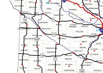
2 State Highway Map Minneapolis Mankato SUBJECT PROPERTY
3 Blue Earth County Minnesota SUBJECT PROPERTY

4 Sterling Township Blue Earth County PARCEL 1 PARCEL 2
5 FSA Aerial View - Parcel 1 PARCEL 1
6 Property Information - Parcel 1 DESCRIPTION: TAX PID #: BUILDINGS: 40± Acres. SW¼ of SW¼, Section 28, T105N-R27R (Note: Not to be used on legal documents) (Sterling Township, Blue Earth County, Minnesota) R None REAL ESTATE TAXES: 2018 Ag Non- Hmstd taxes = $1, Special Assessment = $ Admin Costs (included above) NOTE: Sellers will pay all of 2018 taxes. FSA INFORMATION: Total acres = 40 ± acres FSA Tillable acres = 40.3 ± acres Corn base acres = ± acres Corn PLC Yield =160 ± bushels Soybean base acres = ± acres Soybean PLC Yield = 45 ± bushels Farm Program Info - Enrolled into Agricultural Risk Coverage (ARC) County *This parcel is being split from a larger tract. FSA will recalculate base acres attributed to each parcel after sale. SOIL DESCRIPTION: Beauford, Lura, Collinwood, Marna, Shorewood, Guckeen. See Soils Map. CPI: Crop Productivity Index = 80.7 TOPOGRAPHY: DRAINAGE: Level to rolling Outlet: County Ditch #52-28 & 26, Branch #1-10 & 8 tile. Lateral A - 8 Tile. See County Ditch # 52 Map. Private Tile: Mains and laterals. 90% System Tiled. See Tile Map. NRCS CLASSIFICATIONS ON TILLABLE ACRES: Exempt from conservation compliance provisions. NHEL - Non-Highly Erodible Land WINGERT REALTY & LAND SERVICES, INC. stipulates that they are representing the seller exclusively in this transaction. The information gathered for this brochure in its entirety is from sources deemed reliable, but cannot be guaranteed by Seller, Wingert Realty & Land Services, Inc., or its staff. Package is subject to prior sale, price change, correction or withdrawal. The buyer must make their own independent investigation of the property. The buyer is purchasing the property as is, where is.

7 County Ditch # 52 This tile map is an approximation. No guarantee is made of tile condition, location, size, grade or depth. PARCEL 1 PARCEL 2
8 Tile Map - Parcel 1 This tile map is an approximation. No guarantee is made of tile condition, location, size, grade or depth.

9 Soils Map - Parcel 1

10 FSA Aerial View - Parcel 2 PARCEL 2
11 Property Information - Parcel 2 DESCRIPTION: TAX PID #: BUILDINGS: 80 ± Acres. W½ of NW¼, Section 33, T105N-R27W (Note: Not to be used on legal documents) (Sterling Township, Blue Earth County, Minnesota) R None REAL ESTATE TAXES: 2018 Ag Non- Hmstd taxes = $3, Special Assessment = $ Admin Costs (included above) NOTE: Sellers will pay all of 2018 taxes. FSA INFORMATION: Total acres = 80 ± acres FSA Tillable acres = ± acres Corn base acres = ± acres Corn PLC Yield =160 ± bushels Soybean base acres = ± acres Soybean PLC Yield = 45 ± bushels Farm Program Info - Enrolled into Agricultural Risk Coverage (ARC) County *This parcel is being split from a larger tract. FSA will recalculate base acres attributed to each parcel after sale. SOIL DESCRIPTION: Guckeen, Collinwood, Beauford, Marna, Lura. See Soils Map. CPI: Crop Productivity Index = 83 TOPOGRAPHY: DRAINAGE: TERRACES: Level to rolling Outlet: County Ditch # tile. See County Ditch # 52 Map. Private Tile: Mains & laterals - Substantial system tiling. See Tile Map. 8,350 feet of terraces were installed in the 1980 s. NRCS CLASSIFICATIONS ON TILLABLE ACRES: Exempt from conservation compliance provisions. NHEL - Non-Highly Erodible Land OWNERSHIP: This property has been in the family since January 1, WINGERT REALTY & LAND SERVICES, INC. stipulates that they are representing the seller exclusively in this transaction. The information gathered for this brochure in its entirety is from sources deemed reliable, but cannot be guaranteed by Seller, Wingert Realty & Land Services, Inc., or its staff. Package is subject to prior sale, price change, correction or withdrawal. The buyer must make their own independent investigation of the property. The buyer is purchasing the property as is, where is.
12 Tile Map - Parcel 2 This tile map is an approximation. Wingert Realty & Land Services, Inc. does not guarantee tile maps, footage, tile condition, location, size, grade or depth.

13 Soils Map - Parcel 2
14 Soil Descriptions BEAUFORD SERIES - Soil # 310 These wet soils are clay throughout. They typically have A horizons that are black in the upper part and very dark gray in the lower part, mottled olive gray B horizons and mottled grayish brown C horizons. GEOGRAPHIC SETTING: These soils have slightly convex to slightly concave, nearly level (0 to 2 percent) slopes on glacial lake plains. They formed in 50 inches or more of clayey calcareous lacustrine sediments. Loamy glacial till commonly underlies the sediments at depths of less than 10 feet. These sediments are of Late Wisconsin Age. The climate is humid continental with warm summers and cold winters. Mean annual temperature ranges from 45 to 50 degrees F., and mean annual precipitation ranges from 28 to 32 inches. GEOGRAPHICALLY ASSOCIATED SOILS: The main ones are the very poorly drained Lura soils which formed in similar sediments and are in depressions. A unnamed soil in the very fine, montmorillonitic family of Aquic Hapludolls is a common associated on gentle rises. Also, the moderately well and somewhat poorly drained Guckeen and Collinwood soils which are on higher lying more sloping terrain are associates in some places DRAINAGE AND PERMEABILITY: Poorly drained. Surface runoff is slow. Permeability is slow. LURA SERIES - Soil # 211 The Lura series consists of very deep, very poorly drained and poorly drained soils that formed in clayey glacial lacustrine sediments on glacial lake plains, and ground moraines. These soils have slow permeability. They have slopes of 0 to 2 percent. Mean annual precipitation is about 28 inches. Mean annual air temperature is about 48 degrees F. TYPICAL PEDON: Lura silty clay with a concave slope of about 1/4 percent in a depression on a lacustrine-mantled ground moraine in a cultivated field. GEOGRAPHIC SETTING: Lura soils primarily are in depressions on glacial lake plains and lacustrine-mantled till plains or ground moraines, but some are along drainageways. They have slopes of 0 to 2 percent. These soils formed primarily in clayey lacustrine sediments of Late Wisconsinan Age. Calcareous loam or clay loam glacial till underlies the lacustrine sediments at depths ranging from 40 inches to 10 feet or more. Mean annual precipitation ranges from 26 to 32 inches. Mean annual air temperature ranges from 45 to 52 degrees F. Frostfree days range from 124 to 172. Elevation above sea level ranges from 700 to 1570 feet. GEOGRAPHICALLY ASSOCIATED SOILS: The Beauford, Collinwood, Guckeen, Marna, and Waldorf soils are the main ones. The poorly drained Beauford soils contain more clay than the Lura soils and are associated with them in a few places. The somewhat poorly drained Collinwood and the poorly drained Waldorf soils formed in 48 inches or more of lacustrine sediments and have sola with texture similar to that of the Lura soils. The somewhat poorly drained Guckeen and the poorly drained Marna soils formed in a mantle of clayey lacustrine sediments and have loamy glacial till within depths of 40 inches.
15 Soil Descriptions DRAINAGE AND PERMEABILITY: Very poorly drained and poorly drained. Surface runoff is slow to ponded. Permeability is slow. An apparent seasonal high water table for the undrained phase is at 1 foot above the surface to 1 foot below at some time during November to July in most years for the very poorly drained phase and 1.0 feet to 3 feet for the poorly drained phase. COLLINWOOD SERIES - Soil # 96B, 96D The Collinwood series consists of deep, moderately well drained and somewhat poorly drained soils that formed in clayey, calcareous lacustrine sediments on glacial lake plains. The vegetation was tall grass prairie. The permeability is moderately slow or slow. Slopes range from 0 to 18 percent. Mean annual temperature is about 48 degrees F, mean annual precipitation is about 28 inches. TYPICAL PEDON: Collinwood silty clay--on a slightly convex slope of about 4 percent on a glacial lake plain in a cultivated field. GEOGRAPHIC SETTING: Collinwood soils are on plane to convex slopes on glacial lake plains. Slope gradients are less than 18 percent. Collinwood soils formed mostly in fine textured lacustrine sediments which are 4 to 10 feet thick. These sediments are late Wisconsinan in age. Mean annual temperature is about 45 to 50 degrees F, and mean annual precipitation ranges from about 25 to 30 inches. GEOGRAPHICALLY ASSOCIATED SOILS: Waldorf and Lura soils are the main ones. Waldorf soils are poorly drained and are level. Lura soils are very poorly drained and are in depressions. These soils formed in similar materials. In some places the well-drained Kamrar soils are associated on more sloping terrain and have loam or clay loam C horizons. DRAINAGE AND PERMEABILITY: Moderately well drained and somewhat poorly drained. Surface runoff is slow to rapid. Permeability is moderately slow or slow. MARNA SERIES - Soil # 110 The Marna series consists of very deep poorly drained soils that formed in a clayey glacial lacustrine mantle and the underlying calcareous loamy glacial till on lacustrine plains and ground moraines. These soils have slow permeability. Their slopes range from 0 to 2 percent. Mean annual precipitation is about 28 inches. Mean annual air temperature is about 47 degrees F. TYPICAL PEDON: Marna silty clay with a nearly level slope on a lacustrine mantled till plain in a cultivated field. GEOGRAPHIC SETTING: Marna soils have slightly concave to slightly convex slopes on lake plains and clayey-mantled ground moraines. Their slopes range from 0 to 2 percent. They formed primarily in 24 to 40 inches of clayey glacial lacustrine sediments and calcareous loamy glacial till. The deposits are late Wisconsinan in age. The climate is humid continental with warm summers and cold winters. Mean annual air temperature ranges from 45 to 50 degrees F. Mean annual precipitation ranges from 26 to 32 inches. Elevation above sea level ranges from 900 to 1200 feet. Frost-free days range from 124 to 172. GEOGRAPHICALLY ASSOCIATED SOILS: These are the Kamrar, Guckeen, Brownton, and Lura soils which are members of a hydrosequence with the Marna soils. The well drained Kamrar and the moderately well drained and somewhat poorly drained Guckeen soils are on backslopes, shoulders and summits. The poorly drained calcareous Brownton soils are on nearby low rises and rims of depressions. The very poorly drained Lura soils are in depressions and swales.
16 Soil Descriptions DRAINAGE AND PERMEABILITY: Poorly drained. The apparent seasonal high water table is at 1 to 2.5 feet at some time during November to June in most years. Surface runoff is slow. Permeability is slow. SHOREWOOD SERIES - Soil # 311 The Shorewood series consists of very deep, moderately well drained and somewhat poorly drained soils that formed in a mantle of clayey glacial lacustrine sediments and underlying loamy calcareous till or that formed entirely in lacustrine sediments. These soils are in glacial lake plains and moraines. Permeability is moderately slow or slow. Slopes range from 0 to 12 percent. Mean annual precipitation is about 28 inches. Mean annual temperature is about 47 degrees F. TYPICAL PEDON: Shorewood silty clay loam with a slightly convex 3 percent slope in a cultivated field. GEOGRAPHIC SETTING: Shorewood soils have plane or slightly convex slopes on glacial lake plains and moraines. Slopes generally are about 100 to 250 feet in length with gradients of 0 to 12 percent. The Shorewood soils formed in clayey lacustrine material commonly 30 to 60 inches or more in thickness over friable loam or clay loam glacial till. In some pedons a silty layer up to 3 feet thick is between the clayey layer and the underlying deposits. Mean annual temperature is about 45 to 50 degrees F. Mean annual precipitation is about 25 to 32 inches. Frost free days range from 124 to 165. Elevations above sea level range from 900 to 1200 feet. GEOGRAPHICALLY ASSOCIATED SOILS: These are the Minnetonka, Barbert, and Lura soils which are members of a hydrosequence with Shorewood soils. Poorly drained Minnetonka soils are on nearby level terrain. Very poorly drained Barbert and Lura soils are in depressions and swales. DRAINAGE AND PERMEABILITY: Moderately well and somewhat poorly drained. Surface runoff is medium. Permeability is moderately slow or slow. The perched water table for the moderately well drained phase is 2.5 to 4.0 April to June, and 1.5 to 2.5 for the moderately wet phase in most years.
17 Soil Descriptions GUCKEEN SERIES - Soil # 230 The Guckeen series consists of deep moderately well and somewhat poorly drained soils that formed in a 20 to 40 inch thick mantle of clayey glacial lacustrine sediments and in underlying loamy calcareous glacial till on ground moraines or till plains. These soils have moderate and moderately slow permeability. They have slopes of 1 to 18 percent. Mean annual precipitation is about 28 inches, and mean annual temperature is about 48 degrees F. TYPICAL PEDON: Guckeen silty clay loam with a 2 percent slightly convex slope on a clayey mantled ground moraine, cultivated field. GEOGRAPHIC SETTING: These soils have plane or slightly convex on nearly level to moderately steep till plains or ground moraines. Slope gradients are 1 to 18 percent. These soils formed in a 20 to 40 inch thick mantle of clayey lacustrine sediments and in underlying loamy calcareous glacial till or modified glacial till. These deposits are Late Wisconsinan in age. Mean annual temperature is approximately 45 to 52 degrees F, and mean annual precipitation is approximately 26 to 32 inches. GEOGRAPHICALLY ASSOCIATED SOILS: The main ones are the well drained Kamrar, the poorly drained Marna, and the very poorly drained Lura soils. These soils formed in materials similar to that of Guckeen. Kamrar soils are on higher or more sloping terrain. Marna soils are on adjacent nearly level or level terrain. Lura soils are in depressions. DRAINAGE AND PERMEABILITY: Moderately well and somewhat poorly drained. Surface runoff is medium to rapid. Permeability is slow or moderately slow.
18
19
20 Thank You for the opportunity to present this property to you. We hope you found the information complete and the property of interest. However, if this property doesn t meet your needs, please let us know. We will do our best to find one which satisfies your requirements. Also, if you feel you have no interest in this property, please pass this package along to a friend or associate who might have an interest.
21 Additional Notes
22 SEALED BID AUCTION INSTRUCTIONS Sealed Bid Location and Time: Pioneer Bank 301 Main St NE Mapleton MN Wednesday, August 15, 10:00 a.m. Sealed Bid Instructions: 1. Only registered bidders may attend. Must be registered prior to auction date. All potential bidders shall deliver or mail a sealed bid, postmarked by Friday, August 10, 2018 to: Wingert Realty & Land Services, Inc., Attn: Charles Wingert 1160 Victory Drive So., Suite 6, Mankato, MN **If you are unable to get postmarked bid in on time, call our office for other arrangements.** 2. All bids must be accompanied by a $5,000 check for earnest money made out to Wingert Realty Trust Account. 3. The written bid shall state the total price for total deeded acres. 4. All persons submitting a written bid will be allowed to raise their bid after all bids have been opened. 5. The premises described herein will be sold in as is, where is condition 6. Seller shall pay the real estate taxes and special assessments due and payable in 2018, and receive 2018 income. 7. Purchaser shall pay the real estate taxes and special assessments due and payable in 2019 and beyond and receive income. 8. The successful bidder or bidders will enter into a Purchase Agreement and shall pay as earnest money 10% of the successful bid on the day of auction. 9. A 2% Buyer Premium will be added to the final bid price to arrive at the final contract price. 10. The entire balance of the purchase price, without interest, will be due and payable on Tuesday, September 18, 2018 at which time possession and marketable title shall be conveyed. 11. All checks will be returned to unsuccessful bidder. 12. The Sellers reserve the right to reject any and all bids and to waive any irregularities in the bidding. 13. Announcements made the day of the auction take precedence over written material. For additional information, contact: Wingert Realty & Land Services, Inc. Charles Wingert, ALC, Auctioneer # (800) 730-LAND (5263), LAND (5263) or Direct
 for earnest money made out to Wingert Realty Trust Account.")
23 REGISTRATION/BIDDING FORM Bid Submitting Instructions: Write in your total price for total deeded acres for each parcel you would like to bid on Write in your name, address, telephone number and address All bids must be accompanied by a $5,000 check (this check covers any and all parcels you wish to bid on) for earnest money made out to Wingert Realty Trust Account. Only registered bidders may attend. Must be registered prior to auction date. All potential buyers shall deliver or mail a sealed bid, postmarked by Friday, August 10, 2018 to: Wingert Realty & Land Services, Inc., Attn: Charles Wingert 1160 Victory Drive So., Suite 6, Mankato, MN **If you are unable to get postmarked bid in on time, call our office for other arrangements.** Refer to the Peter & Arlyss Dirkx Farm brochure for further details concerning bidding procedures. Also available to print online: PARCEL 1 PARCEL 2 ACRES PARCEL 1 40 ± PARCEL 2 80 ± PARCEL ± (PARCELS 1+2) TOTAL BID AMOUNT (Nearest $1,000) $ $ $ PARCEL 3 = PARCELS 1+2 NAME: ADDRESS: CITY / STATE / ZIP: CELL PHONE: ( ) /RESIDENTIAL ( ) ADDRESS:
24 WINGERT REALTY & LAND SERVICES, INC. Serving Minnesota and Northern Iowa Mankato Office: Toll Free LAND (5263) Local LAND (5263) CHARLES WINGERT, ALC PAST NATIONAL PRESIDENT OF REALTORS LAND INSTITUTE (2013) Broker Direct Line: DARRELL HYLEN, ALC Real Estate Sales & Lease Negotiation Direct Line: Auctioneer # Auctioneer # DAVID HANSON Real Estate Sales Direct Line: David@WingertRealty.com Auctioneer # Redwood Falls Office: RICHARD HAUGE, ALC & ARA Real Estate Sales & Appraisals Direct Line: Rick@WingertRealty.com Auctioneer # ALL ARE LICENSED MN REALTORS THE LAND REPORT, the magazine of the American Landowner, has named Wingert Realty & Land Services, Inc. America s Best Brokerages and Top Auction Houses in the U.S.A.! 8/6
We are pleased to present Delores Reuter Estate ± Acres Decoria Township, Blue Earth County
 We are pleased to present Delores Reuter Estate 78.48 ± Acres Decoria Township, Blue Earth County This property to be sold by Sealed Bid Auction Owner: Delores Reuter Estate Owner s Attorney: Richard Kakeldey,
We are pleased to present Stattelman Trust - Todd County ± Acres Bertha Township, Todd County
 We are pleased to present Stattelman Trust - Todd County 86.90 ± Acres Bertha Township, Todd County SUBJECT PROPERTY This property to be sold by Sealed Bid Auction Owner: Stattelman Trust; Thomas Stattelman,
Purchase Price: $110,000
 We are pleased to present Laumann Property 40 ± Acres Hunting & Recreation Beauford Township, Blue Earth County Subject Property Access Easement Owners: Laumann Family Location: Two one half mile east
We are pleased to present Kingery Farm 144 ± Acres Worthington Township, Nobles County
 We are pleased to present Kingery Farm 144 ± Acres Worthington Township, Nobles County SUBJECT PROPERTY This property to be sold by Sealed Bid Auction Owner: John Kingery, Ann Schlomann and Paula Seep
We are pleased to present Roland Hammer Children s Trust 80 ± Acres Hantho Township, Lac Qui Parle County
 We are pleased to present Roland Hammer Children s Trust 80 ± Acres Hantho Township, Lac Qui Parle County This property to be sold by Sealed Bid Auction Owner: Roland Hammer Children s Trust - Joe Hammer,
We are pleased to present Cummiskey Farm 80 ± Acres Farmland & Hunting/Rec. Kilkenny Township, Le Sueur County
 We are pleased to present Cummiskey Farm 80 ± Acres Farmland & Hunting/Rec. Kilkenny Township, Le Sueur County SUBJECT PROPERTY View drone video at www.wingertrealty.com This property to be sold by Sealed
Introduction. Implementation of the Village of Capac Master Plan
 Implementation of the Village of Capac Master Plan Introduction The key to a well-planned community is the actual day-to-day use of planning documents, like this Master Plan. Because this plan is to be
KNIGHTS LANDING RIVER RANCH WOODLAND, CA - YOLO COUNTY
 PROPERTY HIGHLIGHTS ±77.2 Gross Acres Contains Excellent Sandy and Silty Clay Loam Soils Established Surface Water Rights in Sacramento River Developed River Diversion and Distribution System Three Phase
Arrowhead Ranch. Located in the Big Range Country of Central Wyoming.
 Arrowhead Ranch Located in the Big Range Country of Central Wyoming. 58 E. Benteen Street Buffalo, WY 82834 Ph 307-684-9556 Toll Free 888-684-9557 Fax 307-684-8565 Location The ranch is approximately:
Region 1 Piney Woods
 Region 1 Piney Woods Piney Woods 1. This ecoregion is found in East Texas. 2. Climate: average annual rainfall of 36 to 50 inches is fairly uniformly distributed throughout the year, and humidity and temperatures
(Short Listing) DUPUYER ACREAGE, ROCKY MOUNTAN FRONT
 DUPUYER ACREAGE, ROCKY MOUNTAN FRONT") (Short Listing) DUPUYER ACREAGE, ROCKY MOUNTAN FRONT This unique property is located 8½ miles northwest of Dupuyer, Montana and approximately thirty 30 miles northwest of Choteau, Montana. Great Falls
(Short Listing) DUPUYER ACREAGE, ROCKY MOUNTAN FRONT This unique property is located 8½ miles northwest of Dupuyer, Montana and approximately thirty 30 miles northwest of Choteau, Montana. Great Falls
HIGH QUALITY FARMLAND PORTFOLIO MONROE COUNTY, ILLINOIS 670 ACRES M/L
 HIGH QUALITY FARMLAND PORTFOLIO MONROE COUNTY, ILLINOIS 670 ACRES M/L HIGH QUALITY FARMLAND PORTFOLIO Monroe County, Illinois 670 Acres M/L Mississippi River St. LOUIS, MISSOURI Monroe CouNTy, Illinois
HIGH COUNTRY L-BAR RANCH
 HIGH COUNTRY L-BAR RANCH Sandoval and mckinley counties N e w m e x i c o Jim Haworth, Ranch Team Lead Broker ~ 505-235-5236 3613 NMSR 528 NW, Ste. H, Albuquerque, NM 87114 505-792-3713 www.wwrealty.com
What Is An Ecoregion?
 Ecoregions of Texas What Is An Ecoregion? Ecoregion a major ecosystem with distinctive geography, characteristic plants and animals, and ecosystems that receives uniform solar radiation and moisture Sometimes
Geoscape Toronto The Oak Ridges Moraine Activity 2 - Page 1 of 10 Information Bulletin
 About 13,000 years ago as the Laurentide Ice Sheet melted, glacial meltwater accumulated between the ice sheet and the Niagara Escarpment. This formed a lake basin into which gravel and sand were deposited.
BRANDON PLANTATION Auction
 BRANDON PLANTATION Auction historical virginia landmark plantation // 23500 brandon road // spring grove, VA in conjunction with richard buckingham OF RE/MAX COMMONWEALTH WEDNESDAY, JUNE 26 at noon In
Roduner Ranch FOR SALE. 5,878± Acres Potential Development Land. Merced County, California. Offices Serving The Central Valley
 FOR SALE 5,878± Acres Potential Development Land Merced County, California Offices Serving The Central Valley F R E S N O V I S A L I A B A K E R S F I E L D 7480 N. Palm Ave, Ste 101 3447 S. Demaree Street
BAsin. - Ranch - Offered at $11,500,000.
 BAsin Greenfield, California Offered at $11,500,000 www.clarkcompany.com 1031 Pine Street Paso Robles, California 93446 Phone: (805) 238-7110 Fax: (805) 238-1324 info@clarkcompany.com BAsin Description
Brinker Creek Ranch. Colorado - Routt County - Yampa
 Located at the base of the Flattops Range in the Steamboat/Vail corridor, Brinker Creek Ranch consists of 1,451 acres ideally suited for high country grazing and native grass hay production. Traditionally
BUCK POINT RANCH. Aspen Associates Realty
 BUCK POINT RANCH Aspen Associates Realty www.aspenassociatesrealty.com 970.544.5800 WELCOME TO Buck Point Ranch is a 960± acre property located in one of the last pristine valleys in close proximity to
Court Ordered Sale ASKING PRICE 2,950,000. DISTRICT LOT 4501 WESTSIDE ROAD 279 ACRES, LAKE OKANAGAN WATERFRONT Central Okanagan Regional District
 Court Ordered Sale DISTRICT LOT 4501 WESTSIDE ROAD 279 ACRES, LAKE OKANAGAN WATERFRONT Central Okanagan Regional District ASKING PRICE 2,950,000 For more information please contact: Brian Tattrie Vice
B HALL RANCH FISHTAIL, MONTANA
 Brochure Courtesy of: B HALL RANCH FISHTAIL, MONTANA w w w. m c c a s l i n l a n d. c o m Page 1 LOCATION The Hall Ranch is ideally located in the foothills of the Beartooth Mountains, approximately 5
Florida Registration No Florida Registration No
 August 22, 2007 7863 Drew Circle, Unit 5 Fort Myers, Florida 33967 Office: (239) 337-9781 Fax: (239) 337-9783 www.williamsearthsciences.com Ms. Teresa N. Puckett, P.E. District One Geotechnical Engineer
2.0 Physical Characteristics
 _ 2.0 Physical Characteristics 2.1 Existing Land Use for the Project The site is comprised of approximately 114 acres bounded by Highway 101 to the north, the existing town of Los Alamos to the east, State
Howard County Land and Home
 Howard County Land and Home A wonderful Howard County property featuring crop land, pasture land, and a nice home. Property Highlights List Price $830,000 $715,000 Location 2087 Merrick Road, Palmer, Nebraska
Cooper Jack Marina TURKS & CAICOS ISLANDS PREMIERE AUCTION MAY 21 AT 5PM ET ULTRA LUXURY THE CARIBBEAN BASIN MULTI-COUNTRY/MULTI-PROPERTY AUCTION
 THE CARIBBEAN BASIN ULTRA LUXURY MULTI-COUNTRY/MULTI-PROPERTY AUCTION PRESENTED BY PREMIERE ESTATES AUCTION COMPANY Cooper Jack Marina TURKS & CAICOS ISLANDS PREMIERE AUCTION MAY 21 AT 5PM ET THE OPPORTUNITY
Acres Monterey County, California OPEN GROUND IN SALINAS VALLEY VEGETABLE AND STRAWBERRY PROPERTY
 324 +- Acres Monterey County, California OPEN GROUND IN SALINAS VALLEY VEGETABLE AND STRAWBERRY PROPERTY EXCLUSIVELY PRESENTED BY: Morris Garcia License 00834407 (559) 994-7453 Cell Sarah Donaldson License
Cabo Rojo BOQUERON BAY, PUERTO RICO AUCTION JUNE 18 AT 5PM ET
 THE CARIBBEAN BASIN ULTRA LUXURY MULTI-COUNTRY/MULTI-PROPERTY AUCTION PRESENTED BY PREMIERE ESTATES AUCTION COMPANY Cabo Rojo BOQUERON BAY, PUERTO RICO AUCTION JUNE 18 AT 5PM ET THE OPPORTUNITY 340-ACRE
Cabo Rojo BOQUERON BAY, PUERTO RICO AUCTION MAY 14 AT 5PM ET
 THE CARIBBEAN BASIN ULTRA LUXURY MULTI-COUNTRY/MULTI-PROPERTY AUCTION PRESENTED BY PREMIERE ESTATES AUCTION COMPANY Cabo Rojo BOQUERON BAY, PUERTO RICO AUCTION MAY 14 AT 5PM ET BOQUERON BAY SITE THE CONCEPTUAL
520± Acre. Las Aldeas Farm. Imperial Valley, CA. agribusiness solutions team. Curtis Buono CA Lic.
 520± Acre Las Aldeas Farm Imperial Valley, CA agribusiness solutions team Curtis Buono 858.558.5629 curtis.buono@cushwake.com CA Lic. #1894905 Matt Davis 858.334.4026 matt.davis@cushwake.com CA Lic. #1758818
MSK HIGHWAY 80 & DEAN FOREST RD PRICING: $649,000. Commercial Parcel. Chuck Mitchell (912)
") PARCEL SIZE: ±6.620 acres. HIGHWAY 80 & DEAN FOREST RD Commercial Parcel ZONING: C-2-A Garden City, GA. The purpose of the C-2-A district is to create and protect areas in which heavy commercial and certain
PARCEL SIZE: ±6.620 acres. HIGHWAY 80 & DEAN FOREST RD Commercial Parcel ZONING: C-2-A Garden City, GA. The purpose of the C-2-A district is to create and protect areas in which heavy commercial and certain
A. Location. Darby Creek Watershed Inventory Final Draft (3/21/2005) 1
 1") I. WATERSHED SETTING The Darby Creek Watershed encompasses about 355,000 acres (555 square miles) and is located just west of the City of Columbus. From its headwaters in Logan County to its confluence
I. WATERSHED SETTING The Darby Creek Watershed encompasses about 355,000 acres (555 square miles) and is located just west of the City of Columbus. From its headwaters in Logan County to its confluence
Morgan Estates. Lassen County, CA. Proudly Offered By
 Morgan Estates Lassen County, CA Proudly Offered By 707 Merchant Street, Suite 100, Vacaville, Ca 95688 (707) 455-4444 Office (707) 455-0455 Fax info@caoutdoorproperties.com Introduction Looking North
Skyland Ranch. At a Glance: Property Features
 Property Features Ideally positioned in an ox box of the mighty Apalachicola River, Skyland Ranch s 2 ½ miles of river frontage form the foundation of this distinctive property. Coveted by recreational
Ranch. Creek. Cow. Mountain
 Cow Creek Mountain Ranch Situated along the southwestern hills of the Laramie Mountains and the Medicine Bow-Routt National Forest in northeastern Albany County, Wyoming. 58 E. Benteen Street Buffalo,
Woodland Mountain Property
 Woodland Mountain Property So Close, Yet So Far Away Summit County, Utah 5 Acres $79,000 3616 Elmwood Street, Salt Lake City, UT 84106 801-870-1801 info@landrancher.com Welcome to Woodland Mountain Enjoy
FOR SALE. 2 Okanagan Self-Storage Facilities. Okanagan Valley, British Columbia. Two storage facilities offered separately or as a package:
 2 Okanagan Self-Storage Facilities Okanagan Valley, British Columbia FOR SALE Penticton, BC Vernon, BC Asking Price: $630,000 Two storage facilities offered separately or as a package: Vernon Mini-Storage,
OWNED LAND ACTIVITIES REPORT February 2012
 OWNED LAND ACTIVITIES REPORT February 2012 BULL RUN MOUNTAINS NATURAL AREA PRESERVE A tremendous number of projects are underway on the Preserve. Currently VOF is working with the Smithsonian Conservation
Berg Ridge BERG RIDGE 1
 Berg Ridge BERG RIDGE 1 Berg Ridge: $13,650,000 ($75,000 / ERU) Jordanelle Basin Wasatch County, Utah LOCATION: North Central Utah in the Jordanelle Basin of Wasatch County a 45-minute drive from downtown
124 Blarney Drive Columbia, South Carolina
 For Sale ±2.99 AC Commercial Land Two N otch Rd. Exit 7 Site 24 Blarney Drive Columbia, South Carolina Exclusively Offered By: Tom Milliken O: + 803 744 9837 C: + 803 33 6999 E: tmilliken@naiavant.com
SALYER LAND COMPANY. Kings and Tulare Counties, California. 1,849.47± Assessed Acres. Exclusively Presented by: Pearson Realty
 Kings and Tulare Counties, California 1,849.47± Assessed Acres F & J Blocks Chandler Ranch Dairy Avenue Ranch Exclusively Presented by: Pearson Realty Offices Serving The Central Valley FRESNO VISALIA
Proposed Project 1: Kimble Loop East Horse Trail Reroute (1). Horse Trail Reroute: March 14, 2012
. Horse Trail Reroute: March 14, 2012") Proposed Project 1: Kimble Loop East Horse Trail Reroute The Ironton District Ranger requests your comments on proposed trail project on National Forest System lands. (1). Horse Trail Reroute: The proposed
Proposed Project 1: Kimble Loop East Horse Trail Reroute The Ironton District Ranger requests your comments on proposed trail project on National Forest System lands. (1). Horse Trail Reroute: The proposed
Glaciers Earth 9th Edition Chapter 18 Mass wasting: summary in haiku form Glaciers Glaciers Glaciers Glaciers Formation of glacial ice
 1 2 3 4 5 6 7 8 9 10 11 12 13 14 15 Earth 9 th Edition Chapter 18 Mass wasting: summary in haiku form Ten thousand years thence big glaciers began to melt - called "global warming." are parts of two basic
GOODRICH CREEK RANCH & RETREAT
 GOODRICH CREEK RANCH & RETREAT A Livestock Grazing Ranch & Hunting Retreat With 1+ miles of beautiful Goodrich Creek, Cambridge, Idaho EXECUTIVE SUMMARY The Goodrich Creek Ranch & Retreat is a very secluded
ARTICLE 7 MOBILE HOME AND RECREATIONAL VEHICLE PARKS AND CAMPGROUNDS
 ARTICLE 7 MOBILE HOME AND RECREATIONAL VEHICLE PARKS AND CAMPGROUNDS Section 701. APPLICABILITY Where a municipality has no subdivision or land development ordinance the provisions of this article shall
Philip, SD Haakon County 370 Acres $475,000
 Philip, SD Haakon County 370 Acres $475,000 The Powell Rd. West property boasts of richly grassed and brushy draws and fertile meadows. This diverse and attractive ranch and recreational property affords
HYDROLOGY OF GLACIAL LAKES, FORT SISSETON AREA
 PROC. S.D. ACAD. SCI., VOL. 77 (1998) 59 HYDROLOGY OF GLACIAL LAKES, FORT SISSETON AREA Perry H. Rahn Department of Geology & Geological Engineering South Dakota School of Mines and Technology Rapid City,
Subject to sale, withdrawal, or error.
 The Crawford L Bar Ranch is located approximately 40 air miles west of Albuquerque, New Mexico. This ranch truly epitomizes the description of New Mexico being the Land of Enchantment. The topography and
Panoramic Views ~11,800 SF Lodge Office & Barns Borders to Mark Twain National Forest. Contact RE Bid Sales for Property & Auction Info, Terms, Etc.
 ELK MOUNTAIN RANCH: For Immediate Sale 800 ACRES WITH LODGE SHANNON COUNTY, MO BUY NOW: Bidding Open, Sellers May Sell Immediately LIVE AUCTION: Feb. 7, 2014 Panoramic Views ~11,800 SF Lodge Office & Barns
Blanco Creek Ranch Acres, Uvalde County, Texas
 Blanco Creek Ranch 1208.30 Acres, Uvalde County, Texas James King, Agent Office 432 426.2024 Cell 432 386.2821 James@KingLandWater.com Blanco Creek Ranch 1208.30 acres Uvalde County, Texas James King,
Gifts of the Glaciers
 Gifts of the Glaciers Gifts of the Glaciers Moving ice of glacier was responsible for water, landforms, and soil characteristics and patterns of today Sculpturing of bedrock materials Glacial Landforms
THE OLSEN RANCH. Paso Robles, California 600+ UNIT PLANNED COMMUNITY DEVELOPMENT OPPORTUNITY. << Click to View Aerial Tour >>
 THE OLSEN RANCH Paso Robles, California 600+ UNIT PLANNED COMMUNITY DEVELOPMENT OPPORTUNITY > OLSEN RANCH TABLE OF CONTENTS OFFERING OVERVIEW... 3 PROPERTY PHOTOS...10 MAPS
THE GHOST ROSE RANCH. Randy J. Wood Qualifying Broker Cell:
 Wild West Properties, LLC 7020 Santa Marisa, NE Albuquerque, NM 87113 505-836-4558 http://www.wildwestproperties.com/ Randy J. Wood Qualifying Broker Cell: 505-980-8019 E-mail: rjwood5@comcast.net THE
Weston County, Wyoming
 The Sweet 200-Acre Property Weston County, Wyoming A unique opportunity to own a little piece of the old West, where one can experience unparalleled scenery, adventure and history walk in the footsteps
The Needle View Ranch
 The Needle View Ranch Hot Springs County, Wyoming Presented by: 58 E. Benteen Street Buffalo, Wyoming 307-684-9556 or 888-684-9557 SUBJECT The Needle View Ranch is located approximately 14.5 miles northwest
Public Notice ISSUED: December 10, 2018 EXPIRES: January 9, 2019
 APPLICANT: REFER TO: St. Louis and Lake Counties Regional Rail Authority 2018-01942-ARC Public Notice ISSUED: December 10, 2018 EXPIRES: January 9, 2019 SECTION:404 - Clean Water Act 1. APPLICATION FOR
NM or AZ Cell Fax at:
 For Sale Exclusively Offered By Azure Enterprises, Inc. P.O. Box 880 Las Vegas, New Mexico 87701 505.454.6000 NM or 480-535-4800 AZ Cell 505-429-0039 Fax 480-295-7997 Email at: lwbrow@gmail.com Forward
Environment and Natural Resources Trust Fund 2014 Request for Proposals (RFP)
") Environment and atural Resources Trust Fund 2014 Request for Proposals (RFP) Project Title: State Parks and Trails Land ERTF ID: 181-G Category: G. Land for Habitat and Recreation Total Project Budget:
Environment and atural Resources Trust Fund 2014 Request for Proposals (RFP) Project Title: State Parks and Trails Land ERTF ID: 181-G Category: G. Land for Habitat and Recreation Total Project Budget:
glacier Little Ice Age continental glacier valley glacier ice cap glaciation firn glacial ice plastic flow basal slip Chapter 14
 Little Ice Age glacier valley glacier continental glacier ice cap glaciation firn glacial ice plastic flow basal slip glacial budget zone of accumulation zone of wastage glacial surge abrasion glacial
BROCHURE. APPLE HILL WOODS 118 +/- Acres Camino, California. Presented by Jim Copeland
 BROCHURE APPLE HILL WOODS 118 +/- Acres Camino, California Presented by Jim Copeland 1 The Property This 118 acre is a rare gem in the Sierra Nevada foothills. Covered with lush forestland and scattered
Indian Creek. Plumas County, California. Proudly Offered By
 Indian Creek Plumas County, California Proudly Offered By 707 Merchant Street, Suite 100, Vacaville, Ca 95688 (707) 455-4444 Office (707) 455-0455 Fax info@caoutdoorproperties.com Introduction House looking
R E P O R T A N D R E M I T T A N C E D U E N O V E M B E R 1
 INSTRUCTIONS FOR BUSINESS REPORTING AND REMITTING OF UNCLAIMED PROPERTY R E P O R T A N D R E M I T T A N C E D U E N O V E M B E R 1 Y O U N G B O O Z E R, T R E A S U R E R A L A B A M A U N C L A I
SECTION 3 GENERAL DESCRIPTION OF THE RIVER BASIN
 SECTION 3 GENERAL DESCRIPTION OF THE RIVER BASIN SECTION 3 GENERAL DESCRIPTION OF THE RIVER BASIN River basin description. A general description of the river basin or subbasin, as appropriate, in which
FOR SALE OR LEASE. St. Croix Meadows Redevelopment LOTS FOR SALE. Hudson, WI
 St. Croix Meadows Redevelopment EXIT RAMP EXISTING OVERPASS VACATE R.O.W. CARMICHAEL RD ON RAMP HIGH-TECH/FLEX SPACE MEDICAL OFFICE - 20K SF EACH RETAIL / ENTERTAINMENT 24-46K SF FULL ACCESS CORPORATE
HUNTING/CATTLE RANCH
 HUNTING/CATTLE RANCH 6,400 DEEDED ACRES IN CATRON COUNTY, NEW MEXICO OFFERED EXCLUSIVELY BY HITCHING POST LAND CO. & SOUTHWEST PROPERTIES, INC. DAVID WOLFSWINKEL, BROKER Office 480-969-8000 Cell 602-377-2368
INTRODUCTION. Mailing address: Burke County Community Development Attn: Tim Johnson P. O. Box 219 Morganton, NC
 REQUEST FOR QUALIFICATIONS: PROFESSIONAL, EXPERIENCED TRAIL BUILDERS FOR THE CONSTRUCTION OF THE FONTA FLORA STATE TRAIL LAKE JAMES SECTION BURKE COUNTY COMMUNITY DEVELOPMENT INTRODUCTION Burke County
2015 Brain Wrinkles. SS8G1b
 SS8G1b Georgia is a geographically diverse state that is divided into five regions. The first three regions (Appalachian Plateau, Valley and Ridge, and Blue Ridge) are in the mountains and foothills of
FOR SALE $659, Unit Medical/Office. Building Two story medical / office building on ±2.118 Acres in Boiling Springs, NC.
 4-Unit Medical/Office Bank Owned Building Two story medical / office building on ±2.118 Acres in Boiling Springs, NC BANK-OWNED & PRICED TO SELL $659,000 SEE INSIDE FOR MORE INFORMATION! 327 West College
FOR SALE. Log Home on 2.27+/- Acres Custer County, South Dakota Offered at $647,000.
 FOR SALE Highlight Features: 5,134 square foot, four bedroom, three and a half bath Cypress Log Home City water and sewer Easy access to endless recreational opportunities Only five minutes to Custer State
GLACIATION. The Last Ice Age (see Chapter 12) and. Pleistocene Ice Cap. Glacial Dynamics 10/2/2012. Laurentide Ice Sheet over NYS
 and. Pleistocene Ice Cap. Glacial Dynamics 10/2/2012. Laurentide Ice Sheet over NYS") GLACIATION and New York State Prof. Anthony Grande The Last Ice Age (see Chapter 1) The Pleistocene Epoch began 1.6 mya. During this time, climates grew colder. There were numerous ice ages starting 100,000000
GLACIATION and New York State Prof. Anthony Grande The Last Ice Age (see Chapter 1) The Pleistocene Epoch began 1.6 mya. During this time, climates grew colder. There were numerous ice ages starting 100,000000
Tracy Ranch 403+/- Acres Comanche County, Texas $965,185 ($2,395/acre)
") Office: (214) 361-9191 Tracy Ranch 403+/- Acres Comanche County, Texas $965,185 ($2,395/acre) LOCATION: The ranch is located in the northwestern portion of Comanche County near the Eastland County line,
Office: (214) 361-9191 Tracy Ranch 403+/- Acres Comanche County, Texas $965,185 ($2,395/acre) LOCATION: The ranch is located in the northwestern portion of Comanche County near the Eastland County line,
FOR SALE $899, Hwy 385, Rapid City, SD. Sandra Runde CCIM, SIOR, Commercial Broker
 Seven Room Bed & Breakfast with Restaurant in the heart of the Black Hills $899,300 23191 Hwy 385, Rapid City, SD Exclusively Listed By: Sandra Runde CCIM, SIOR, Commercial Broker 605-391-7500 skrunde@gmail.com
Glaciers and Glaciation Earth - Chapter 18 Stan Hatfield Southwestern Illinois College
 Glaciers and Glaciation Earth - Chapter 18 Stan Hatfield Southwestern Illinois College Glaciers Glaciers are parts of two basic cycles: 1. Hydrologic cycle 2. Rock cycle A glacier is a thick mass of ice
HEADQUARTERS WEST LTD. PHOENIX - TUCSON - SONOITA - COTTONWOOD - ST. JOHNS
 Offered for sale exclusively by: Walter Lane Headquarters West, Ltd. PO BOX 37018 Tucson, AZ 85740 Phone (520) 792-2652 info@headquarterswest.com www.headquarterswest.com General Area Description The Crown
Big Sandy Ranch Mohave County, Arizona
 Big Sandy Ranch Mohave County, Arizona Photo [9] Deeded land on hillside within the River Ranch parcel Listed for sale exclusively by: Traegen Knight Headquarters West Ltd. PO BOX 1980 St. Johns, AZ 85936
Glacial Geomorphology Exercise
 James Madison University Field Course in western Ireland Glacial Geomorphology Exercise 3-day road log (abbreviated) Striations Large kame terrace Cirque with moraines Kame delta Striations Eskers Raised
House, Buildings & 4.56 Acres m/l Linn County, IA Old Quaas Road, Alburnett, Iowa 52202
 HOUSE FOR SALE House, Buildings & 4.56 Acres m/l Linn County, IA 2713 Old Quaas Road, Alburnett, Iowa 52202 Property Information Location From Alburnett: ½ South on Alburnett Road and ½ west on Old Quaas
Buffalo Springs Ranch
 Buffalo Springs Ranch Acton, Montana For additional details, contact: SCOTT R. GROSSKOPF Broker / Owner Member Landmark of Billings 1925 Grand Avenue, Ste. 144, Billings, MT 59102 Office: (406) 248-3101
GLACIER STUDIES OF THE McCALL GLACIER, ALASKA
 GLACIER STUDIES OF THE McCALL GLACIER, ALASKA T John E. Sater* HE McCall Glacier is a long thin body of ice shaped roughly like a crescent. Its overall length is approximately 8 km. and its average width
AUCTION BIDDING You may bid online during the auctions at www. LIVE ONLINE PORTFOLIO OVERVIEW
 PORTFOLIO OVERVIEW STATE COUNTY/ PARISH ACRES CROPLAND (FSA) AUCTION DATE Illinois Mercer 4,869± 4,657± Illinois Fulton 3,769± 3,596± December 12 Texas Hartley 11,240± Texas Moore 920± 11,646± December
EAST COCALICO TOWNSHIP BOARD OF SUPERVISORS MEETING AGENDA
 EAST COCALICO TOWNSHIP AGENDA HELD AT EAST COCALICO TOWNSHIP, 100 HILL ROAD, DENVER, PA 17517 at 7:30 P.M. MEETING CALLED TO ORDER AT 7:30 P.M. FARMLAND TRUST PROJECT PRESENTATION BY STEPHANIE ARMPRIESTER
CRI Loreto. IIAP crew seining for Colossoma macropomum broodstock at the CRI Loreto research site in Peru.
 PERU CRI Loreto 43 PD/A CRSP SITE DESCRIPTIONS CRI Loreto Marcos J. De Jesús Marcos J. De Jesús IIAP crew seining for Colossoma macropomum broodstock at the CRI Loreto research site in Peru. Hatchery facilities
Crown Lands and Property Agency. Name Client # LAST (Please Print) FIRST MIDDLE (no initials) Mailing Address. Postal Code
 FIRST MIDDLE (no initials) Mailing Address. Postal Code") Manitoba Conservation and Water Stewardship Application for Permit/Lease/Purchase/Easement/Exchange/Licence of Occupation (under The Crown Lands Act c.c340) Please check one ( ) Permit Lease Purchase Easement
Manitoba Conservation and Water Stewardship Application for Permit/Lease/Purchase/Easement/Exchange/Licence of Occupation (under The Crown Lands Act c.c340) Please check one ( ) Permit Lease Purchase Easement
REGULATIONS FOR DECLARATION AND DISPOSAL OF UNCLAIMED ITEMS OF THE PIRAEUS CONTAINER TERMINAL S.A. IN THE PIRAEUS FREE ZONE
 REGULATIONS FOR DECLARATION AND DISPOSAL OF UNCLAIMED ITEMS OF THE PIRAEUS CONTAINER TERMINAL S.A. IN THE PIRAEUS FREE ZONE Article 1 Goods declared unclaimed deadlines Goods unloaded and received by the
Mountain Valley Pipeline, LLC Mountain Valley Pipeline Project Docket No. CP
 16. Prior to construction, Mountain Valley shall file with the Secretary, for review and approval by the Director of OEP, a segment-specific construction and operation access plan for the area between
Specification for Grip blocking using Peat Dams
 Technical Guidance Note 1 Specification for Grip blocking using Peat Dams 1. Introduction Moorland drains (grips) have been dug across much of the Yorkshire upland peatlands. Many of these grips have become
Commercial Property Client Full
 Commercial Property Client Full 138 High Mountain Road, Hot Springs NC 28743 MLS#: 3457189 Category: Commercial Parcel ID: 8769-48-0995 + 2 Status: Active Tax Location: Hot Springs County: Madison Project
The Physical Geography of Long Island
 The Physical Geography of Long Island A Bit About Long Island Length 118 miles Brooklyn to Montauk Geo202 Spring 2012 Width 23 miles at it s widest Area 1,400 square miles Formation of Long Island River
GILBERT & WEST TOWN INTERCOUNTY DRAIN Windsor Township, Eaton County and City of Lansing, Delhi Township, Ingham County, Michigan
 GILBERT & WEST TOWN INTERCOUNTY DRAIN Windsor Township, Eaton County and City of Lansing, Delhi Township, Ingham County, Michigan PRELIMINARY ENGINEERING REPORT Abigail Eaton, Chair Intercounty Drains
434 VT-114, Averill, VT
 434 VT-114, Averill, VT Curtis Trousdale, Owner, Broker, Realtor Cell: 802-233-5589 curtis@preferredpropertiesvt.com 2004 Williston Road, South Burlington VT 05403 www.preferredpropertiesvt.com Phone:
AC Bid Upgrade. Terms and Conditions
 AC Bid Upgrade Terms and Conditions 1. The following terms and conditions ("Terms and Conditions") shall apply to a bid ( Offer ) made by you ( you ) to Air Canada ( Airline ) for an opportunity to upgrade
Preliminary Site Evaluation
 Preliminary Site Evaluation 100 Acre Site, US 72 Piperton, Tennessee Power Distributor: Chickasaw Electric Cooperative August 2010 SITE DATA SHEET PIPERTON US 72 SITE (100 ACRES): LOCATION & GENERAL DESCRIPTION
INVITATION FOR BID VENDOR: BID OPENING:
 Wicomico County Purchasing Department 125 N. Division Street, Room B3 Salisbury, Maryland 21801 INVITATION FOR BID PROJECT: Aircraft Rescue and Firefighting Live-Fire Training DEPARTMENT: Salisbury-Ocean
Subject to sale, withdrawal, or error.
 CANYON DEVELOPMENT PROPERTY RANDALL COUNTY, TEXAS 381.38± ACRES *Drawing For Illustration Only We are pleased to offer the exclusive listing on the. Located in the Texas Panhandle near Canyon and Amarillo,
5 Acres of Commercial Land - Los Banos, CA
 5 Acres of Commercial Land - Los Banos, CA Hwy 152 Major Credit All or Part $2,300,000 Subject Property Renz & Renz George L. Renz, CCIM george@renzrenz.com 408.846.1031 Summary of Salients 5 Acres of
City of Redding Airports
 City of Redding Airports Benton Airpark Redding Municipal Airport DEVELOPMENT AND USE GUIDELINES FOR GENERAL AVIATION HANGARS April 7, 2009 PREFACE The City of Redding, as owner of federally obligated
Notice of Public Meeting of the DES MOINES AIRPORT AUTHORITY BOARD. Agenda
 Notice of Public Meeting of the DES MOINES AIRPORT AUTHORITY BOARD DATE: February 14, 2017 TIME: 9:00 a.m. PLACE: Airport Board Room, 2nd Floor, Airport Terminal Call to Order and Roll Call Agenda 1. Consider
MIDDLE SCHOOL CURRICULUM TR AILING ICE AGE M YST ERI E S SEARCHING GLACIAL FEATURES
 MIDDLE SCHOOL CURRICULUM TR AILING ICE AGE M YST ERI E S SEARCHING GLACIAL FEATURES CONTENTS I. Enduring Knowledge... 3 II. Teacher Background... 3 III. Before Viewing the Video... 5 IV. Viewing Guide...
Archaeological Monitoring at Ham Farm, Ham Road, Faversham, Kent
 Archaeological Monitoring at Ham Farm, Ham Road, Faversham, Kent NGR: 601750.0mE 162695.0mN Site Code HAM/WB/12 Report for A.J. Bray SWAT ARCHAEOLOGY Swale and Thames Archaeological Survey Company The
Adjacent Land Tresspass 1. Adjacent Land Tresspass 1
 ID 80 Water Access/Public Roads Fact Sheet LEGAL Section Township Range LOTS 8 & 9, BLK 1 22 140 28 County Lake Name Plat Name Road Name Cass WABEDO WABEDO PASS WABEDO PASS RD NE Adjacent Lot 1 N REMALEY,