International Appalachian Trail. Trail Guide. East Branch of the. Penobscot River. Maine. Baxter State Park to. Grand Lake Road
|
|
|
- Allison Stone
- 6 years ago
- Views:
Transcription

1 International Appalachian Trail Trail Guide East Branch of the Penobscot River Maine Baxter State Park to Grand Lake Road Maine Chapter International Appalachian Trail August 1, 2012
2 Acknowledgments This guide was made possible by a grant to the Maine Chapter of the International Appalachian Trail from the Quimby Family Foundation. Contributing to its preparation were: Editor Cartography and Design Principal Author Contributing Writers Herb Hartman Bill Duffy Bart DeWolf Judith Ann Eldridge Don Hudson Paul Johnson Earl Raymond Most of the trail between Baxter State Park and the Grand Lake Road is on land owned by Elliotsville Plantation, Inc. ( whose mission is the acquisition and conservation of land and the preservation of open space for the benefit of the public and for the conduct of educational and stewardship programs in furtherance of land conservation. EPI s support and cooperation with the Maine Chapter of the IAT in the location and management of this trail section is gratefully acknowledged. ii
3 Table of Contents Contents Acknowledgments...ii History of the IAT...1 The East Branch Section of the IAT...2 Hiker Information...4 Baxter Park Rules...5 General Information...6 Trail Guide Information...7 Trail Guide...9 Human History...34 Logging...38 Tourism and Recreation...40 Natural History...42 Flora and Fauna...49 iii
4 Notice to All Hikers The information in this trail guide is the result of the best effort of the Maine Chapter of the International Appalachian Trail, using the most recent data available at the time of printing. Changes resulting from weather and natural events, maintenance work, and trail improvements are constantly occurring and, thus, no hardcopy guide can be regarded as precisely accurate at the time a hiker may travel. Maintenance of the IAT is conducted annually in the spring and fall by members of the Maine Chapter of the IAT and other volunteers. Reports on trail work are posted on the Maine Chapter s website: For the most up-to-date information of trail conditions please contact Dick Anderson at randerson19@maine.rr.com or by phone at Thank you, The Editors August 1, 2012 iv

5 History of the IAT With the leadership of Dick Anderson, the Maine Chapter of the International Appalachian Trail (IAT) was incorporated in 1994 to promote the establishment of a long-distance hiking trail from the eastern boundary of Baxter State Park, where Mt Katahdin is the northern terminus of the Appalachian Trail, to the northern end of the Appalachians in North America. Although the North American segment of the IAT ends at Crow Head, Newfoundland and Labrador, millions of years ago drifting continental land masses (tectonic plates) first collided to form the ancestral Appalachians and then separated to form the continents one sees today, including North America, Europe, and Africa, each carrying a piece of the original Appalachians. The long-term IAT goal is to locate sections of the trail on all the terranes of the original Appalachians. In addition to the Maine Chapter, the IAT has other North American chapters responsible for the trail in New Brunswick, Quebec (referred to as the SIA, Sentier International des Appalaches), Nova Scotia, Prince Edward Island, Newfoundland and Labrador, and Greenland. European IAT chapters have now been established in Ireland, Scotland, England, Wales, Iceland, the Faroe Islands, Norway, Sweden, Denmark, the Netherlands, Spain, and France. Portugal and Morocco may be next. 1
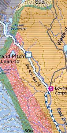
6 The East Branch Section of the IAT Hay Lake Matagamon Wilderness Camps and Store Billfish Mtn International Appalachain Trail Connector or Alternate Trails Rd Grand Lake Limited Access Gravel Roads Abandoned Logging Roads IAT Leanto Bald Mtn Primative Campsite Private Campground North Traveler Mtn Gate or Access Point The Oxbow 100 Foot Contour Sebo Baxter State Park Boundary eis 1 Bowlin Pond ot st ARK KILOMETERS MILES 2 o Tel Messer Pond 2 1 O ld Grand Pitch Lean-to South Traveler Mtn APPROXIMATE DECLINATION 17º WEST er RTH 0 0 Riv. NO MAG The Traveler TRUE NORTH Haskell Deadwater e Bowlin Camps S Bear Mtn ch ran tb Eas TAT E Mes ser Pond - O rin Falls Rd P R d Lunksoos Lake AXTER e iv tr co bs no Pe as W B r sa North Turner Mtn ta qu Hathorn Mtn oi k St re m Lunksoos Mtn a Lunksoos Lean-to South Turner Mtn Wassataquoik Lean-to Katahdin Lake Deasey Mtn Barnard Mtn Roaring Brook Campground S ra rt il oi k Rd 2 KLE Access Point ta qu m ea tr Avalanche Field ahdin Lake Tr sa as W Kat at e hw Hig

 Access trail head at Baxter State Park and runs to the Grand Lake Road near the outlet of")
7 The IAT in Maine The Maine section of the IAT is 138 miles (222 kms) long. Heading north from Baxter State Park, the route passes through boreal forests and follows trails, old logging roads, an abandoned railroad bed, and rural public roads to the potato fields of Aroostook County. Beyond Fort Fairfield, the trail enters New Brunswick. The East Branch Section The East Branch Section of the IAT in Maine begins at the Katahdin Lake East (KLE) Access trail head at Baxter State Park and runs to the Grand Lake Road near the outlet of Matagamon Lake. The section is approximately 30 miles long and parallels the East Branch of the Penobscot River for much of its length. The trail is remote and difficult to access in the event of an emergency. It includes two mountain summits (Deasey and Lunksoos), some off-road trail that is of medium difficulty, and one major stream crossing (Wassataquoik Stream see page 33). Most of this section is on land owned by Elliotsville Plantation Inc. and is managed as a wildlife preserve. Hunting, trapping, wood harvesting, and motorized vehicles are not allowed. 3

8 Hiker Information Getting to Baxter State Park (BSP): Hiker parking is available at the Park s Avalanche Field parking area, the start of the trail to the Katahdin Lake East (KLE) Access point of BSP. By bus: Buses leave from Logan Airport and Boston s South Station to Portland, Maine and from Portland to Bangor. Transfer to Cyr Bus Service. Buy one ticket from Boston to Medway, Maine (near Millinocket) at South Station from Concord Coach Lines; By train: Instead of taking the bus in Boston, one can take the Amtrak train that leaves several times daily from Boston s North Station to Portland s combined train and Concord Coach Lines bus station. Cyr Bus Service: Services Bangor, Medway, Houlton, Mars Hill, Bridgewater, Monticello; and Medway: Cyr buses stop at a gas station convenience store right off of I-95. Traffic flows toward Millinocket on Maine 157, then on to BSP, so hitchhiking is usually fairly easy. One can also call Katahdin Taxi, or USA.TAXI, to get to the entrance of Baxter State Park. Medway has few services along ME 157. Lodging: Katahdin Shadows Motel and Campground, or Millinocket: Post Office 04462: Most major services are available in the Millinocket area, especially in the strip mall east of town on ME 157, where you ll find lodging: Best Western ; Pamola Motor Lodge, , after 4 p.m ; grocery stores, a pharmacy, fast-food chains, a bank with ATM, and the administrative offices of Baxter State Park. In-town lodging: Appalachian Trail Lodge,

9 Baxter Park Rules Pets are not allowed in the park and advance reservations are required for all overnight facilities including campgrounds. Hikers arriving in the park without a reservation will not be allowed to camp. One cannot enter the park on foot, ascend Katahdin, and leave the park on foot in one day, a trek of more than 20 miles, including the climb of Maine s tallest mountain. Most hikers will stay at least one night in the park in order to climb Katahdin safely and successfully complete the IAT in Maine. If you are planning on climbing Katahdin, make arrangements to stay overnight at Roaring Brook or Chimney Pond and hike from there, an 8-12 hour round trip. In addition to camping managed by Baxter Park at Katahdin Lake, Roaring Brook, and Chimney Pond, hikers may make advance reservations to stay at Katahdin Lake Wilderness Camps ( a few miles from the intersection of the IAT with the eastern boundary of the park, but a day climb of Katahdin from Katahdin Lake is not a viable option. For reservations and important information on Park use, rules and rates, contact Clerk, Baxter State Park Authority, 64 Balsam Drive, Millinocket, ME 04462; telephone Reservations may be made on line through the Park s website at Credit cards are not accepted inside the Park. Pay before arrival or expect to pay in cash. Park campgrounds are in high demand during the busiest part of the season, which includes weekend nights in the fall. SOUTH-BOUND IAT HIKERS The last trailside location to contact Baxter Park by phone or internet is Shin Pond Village ( All south-bound hikers are encouraged to make their arrangements from Shin Pond Village, if not earlier during their hike through Maine. For more through hiker information please visit: 5

10 General Information Camping: The East Branch Section of the trail has three lean-to shelters with fire rings and privies: Wassataquoik Stream, Lunksoos, and Grand Pitch. Maine Forest Service campsites are found along the IAT north of the Grand Pitch Lean-to at Pond Pitch and Haskell Deadwater, and require a fire permit except when the ground is snow covered. You can request a free fire permit for these sites by calling the MFS regional office in Ashland, Fires are not permitted at other locations along this stretch of trail. Camping is available at the Matagamon Wilderness Store at the terminus of this section. Campsite Distances Distance from KLE Campsite 5.5 mi / 8.9 km Wassataquoik Lean-to 13.3 mi / 21.4 km Lunksoos Lean-to 23.3 mi / 37.5 km Grand Pitch Lean-to Drinking Water: Water is available along or adjacent to the trail and campsites. Hikers should not assume that it is always safe to drink without treating with a disinfectant, filtering, or boiling for at least 5 minutes. Biting Insects: Black flies, mosquitoes, and no-see-ums (sand flies) can sometimes be maddening, the first in the spring, and the latter two especially in the evening. A good fly repellent is recommended. Trail Marking: Much of this section is marked with the IAT tag (photo) or flagging tape. Some critical junctions will have a post with a tag and arrow. Special attention may be needed to follow the trail where it crosses ledge and at the Wassataquoik Ford or on the alternative High Water Crossing route. Search and Rescue: Cell phone service is generally unavailable on the East Branch section, though sometimes a signal is obtainable on the mountain summits. In case of emergency, call State Police dispatch, 911, which will alert the appropriate responders. Bowlin Camps [ ] also has phone service. Carry In-Carry Out: Hikers should leave no trace and carry out all trash. Trash receptacles are available at the Matagamon Wilderness Store. 6
11 Legend Map Information MI 7.0 IAT Lean-to River Ford International Appalachian Tr Gate (normally closed) IAT Trail Mileage Gate (normally open) Improved MFS Campsite Known Road Closures Primitive Campsite Paved Road Private Sporting Camps Maintained Gravel Road Historic Site Unmaintained Gravel Road Natural Feature Abandoned Gravel Road IAT Sign Post Trail Rapids Town line Falls County line Topography and base map features from USGS 7.5 quadrangle maps Map oriented to true north Magnetic declination approximately 18º west About the Guide This guide for the East Branch Region of International Appalachian Trail in Maine is organized into three general sections. The first section consists of a few pages of information that every IAT hiker should know when planning their hike in Maine, including local transportation information and Baxter State Park rules. The next section contains detailed topographic maps of the East Branch region of the IAT. The Trail data have been divided into six maps covering the 31 miles of IAT from Baxter State Park to the Grand Lake Road. An additional map covers the alternate high-water trail. Each map is accompanied by a mileage guide with the distance from the southern terminus of the IAT to significant points along the Trail, such as lean-tos, stream crossings and important turns. Many of the maps are followed by a page listing interesting historical or natural features the hiker may pass on that particular portion of the trail. The special feature text is highlighted in yellow. The final section of the guide describes the human and natural history of the East Branch region in detail. This section includes readings and photos to whet the appetite of the curious hiker. Further readings are listed at the end of the guide. 7
12 Wassataquoik Stream MAG. NORTH TRUE NORTH MONUMENT LINE BAXTER STATE PARK MI 3.1 MI 2.4 Barnard Mtn 1616 Katahdin Lake Rocky Pond MI 1.7 Katahdin Lake Wilderness Camps Katahdin Lake Tr MI 0.0 KLE Access Point MI Kilometer 1 Southern Terminus of IAT 0 Mile 1 8

13 Trail Guide The International Appalachian Trail begins at the Katahdin Lake East (KLE) Access of Baxter State Park that can be reached via the Katahdin Lake Trail from the Avalanche Field parking area located 1.5 miles south of the Roaring Brook Campground on the Roaring Brook Road. From Avalanche Field, follow the Katahdin Lake Trail 3.3 miles to Katahdin Lake Wilderness Camps. Continue east on the Katahdin Lake Trail, reaching the Baxter State Park KLE Access in 1.8 miles. Mile Description 0.0 The IAT begins at the Katahdin Lake East (KLE) Access of Baxter State Park. After signing out at the Registration Box located at the Park boundary, follow the old logging road east. 0.3 Reach the intersection of the old logging road and the Gardner Rd (IAT post), from which one can see Katahdin to the west and Barnard Mtn to the north. Turn north on the Gardner Rd. 1.7 Cross Katahdin Brook downstream of the large ditch in the road using the bypass that has been flagged and tagged. Continue north up a long grade on the Gardner Rd. 2.4 Intersection of Gardner Rd and a logging road (IAT post). Turn right and continue east on the logging road, circling Barnard Mountain to the north and continuing to the intersection of the old Wassataquoik Stream Rd. Barnard Mountain Summit: Barnard Mountain (1,621 ft) is an easy climb to a tree-covered summit with nice but restricted views of Katahdin and Katahdin Lake. From the IAT north of the mountain (Mile 3.1), follow the obvious logging road southeast to its end, and then bushwhack west-northwest 0.4 miles to the summit. 9
14 TRUE NORTH MAG. NORTH Lookout Ledge MI 9.5 MI 9.1 Owen Brook MI 5.0 MI 5.5 MI 6.0 MI 6.8 MI 7.0 MI 10.8 MI 7.8 MI 7.5 MI 10.0 MI 8.4 Old Keep Path Orin Falls Wassataquoik Ford Katahdin Esker Fire Lookout 1964 Deasey Mtn Earl's Erratic Fire Wardens Cabin High Water Trail Logging Rd Wassataquoik Stream Wassataquoik Stream Rd Wassataquoik Lean-to Katahdin Brook 0 Kilometer 1 0 Mile 1 m 10
15 Mile Description 5.0 Reach the Wassataquoik Stream Rd (IAT post). Follow the Wassataquoik Stream Rd south 0.5 mile to the Wassataquoik Lean-to and campsite. 5.5 Reach the Wassataquoik Lean-to campsite. The IAT continues south on the Wassataquoik Rd crossing Katahdin Brook and following the top of a steep esker. 6.0 Reach a trail to the left (IAT post) that leads down to the Wassataquoik Stream ford (see note about fording in high-water page 33). 6.2 Reach Wassataquoik Stream. Cross the stream a few yards upstream of the trail where it is shallower. Walking across the stream, aim for an IAT tag on a large tree. After the ford, the trail turns right (southeast) and parallels the stream. 6.8 The trail turns northeast, crosses a gravelly area and the mouth of a tributary (some wading may be required) and ascends a steep bank where it shortly joins the Old Keep Path, the route of many early ascents of Katahdin. 7.0 Continuing southeast along the Old Keep Path, the trail edges close to Wassataquoik Stream one last time, crosses a small tributary and turns northeast. 7.5 The trail leaves the Old Keep Path and turns northeast and climbs up to the col between Deasey Mtn and a small unnamed hill to the south. 7.8 Trail passes Earl s Erratic a house sized boulder located in an exemplary, hardwood forest setting. 8.4 Trail crosses Owen Brook (water source). 9.1 After wandering through an impressive older forest of hemlock, pine, spruce and birch the trail turns north (laminated sign) and climbs over the east ridge of Deasey Mtn 9.5 A short spur trail (east) leads to a fine viewpoint overlooking the East Branch of the Penobscot River. The trail continues west, descending slowly though a stand of old hemlock Trail crosses a fine stream (last sure water until Lunksoos Lean-to) and reaches the abandoned (and dilapidated) remains of the old Deasey Fire Warden s cabin. The trail passes in front of the cabin, turns left and begins a steep climb northwest towards the summit of Deasey Mtn 10.8 Trail turns sharply right (north) just below the summit of Deasey Mtn A short spur trail (laminated sign) leads to the summit of Deasey and the historic Ground Cab fire lookout, which provides fine 360º views. From the junction with the summit spur trail, the IAT drops into the col between Deasey and Lunksoos Mtns. 11
16 TRUE NORTH MAG. NORTH Lookout Ledge MI 9.5 MI 9.1 Owen Brook MI 5.0 MI 5.5 MI 6.0 MI 6.8 MI 7.0 MI 10.8 MI 7.8 MI 7.5 MI 10.0 MI 8.4 Old Keep Path Orin Falls Wassataquoik Ford Katahdin Esker Fire Lookout 1964 Deasey Mtn Earl's Erratic Fire Wardens Cabin High Water Trail Logging Rd Wassataquoik Stream Wassataquoik Stream Rd Wassataquoik Lean-to Katahdin Brook 0 Kilometer 1 0 Mile 1 m 12


17 Wassataquoik Stream and Orin Falls Described by Myron Avery as a brawling mountain torrent of the clearest water, tumbling along a bed choked with enormous pink boulders, the Wassataquoik descends in continuous rapids from Baxter State Park to the Penobscot s East Branch, a distance of about 14 miles. Once a scene of intense logging activity in the 19th century, it is now one of the wildest, least-developed watersheds in the northeast. The Wassataquoik Stream Rd was built along the stream to support logging operations in the 1950 s and early 60 s. Orin Falls is an attractive stretch of rapids well worth a visit. From the junction of the IAT and the Wassataquoik Stream Rd follow the road northwest about 1.5 miles to where a small side trail leads north to the rapids. Eskers and Erratics Eskers and erratics are both reminders that most of New England and Canada were covered in mile-thick glacial ice approximately 15,000 years ago. Eskers are long, sinuous, steep-sided ridges of sand and gravel formed by melt water streams running beneath a retreating glacier. Glacial erratics are boulders that have been plucked from mountains by a glacier, transported some distance and deposited in an area with a different bedrock composition. The Katahdin Esker parallels Wassataquoik Stream and the East Branch, one of many prominent eskers in the region. Early logging operators took advantage of their well-drained and relatively level crests and located several of the tote roads that penetrate the region on them. The esker along the East Branch was noted by C. T. Jackson in 1837 and Henry David Thoreau in 1857, and was explored in some detail by George H. Stone in 1879 who traced its course 125 miles to the ocean near Columbia, Maine. Earl s Erratic, named for Earl Raymond, the Maine Chapter s director who found it, is a house sized piece of Ordovician basalt located in an exemplary, hardwood forest setting. It likely traveled only a few miles from the cliffs on the northwest side of Deasey Mountain. 13
18 TRUE NORTH MAG. NORTH Lookout Ledge MI 9.5 MI 9.1 Owen Brook MI 5.0 MI 5.5 MI 6.0 MI 6.8 MI 7.0 MI 10.8 MI 7.8 MI 7.5 MI 10.0 MI 8.4 Old Keep Path Orin Falls Wassataquoik Ford Katahdin Esker Fire Lookout 1964 Deasey Mtn Earl's Erratic Fire Wardens Cabin High Water Trail Logging Rd Wassataquoik Stream Wassataquoik Stream Rd Wassataquoik Lean-to Katahdin Brook 0 Kilometer 1 0 Mile 1 m 14


19 Keep Path Parts of the route of the IAT north of Wassataquoik Stream follow the old Wassataquoik tote road which coincides here with the Keep Path - the route pioneered in the 1840 s by Marcus Keep to Katahdin Lake and on to the summit of Katahdin via the Keep Ridge. The Wassataquoik tote road extended west into Baxter State Park and although pieces of it can still be found, it is now mostly overgrown. Fire Warden s Cabin Located in a clearing along the fire warden s trail to the Deasey Mountain lookout, the cabin was summer home to fire warden Ed Werler and his wife Mary Jane for three years from 1947 to 1949, and is described in The Call of Katahdin, Werler s colorful account of his years working for the Maine Forest Service and Baxter State Park 1. Deasey Summit Fire Warden's Cabin ca Reached from the IAT by a short spur trail to the southwest, the open Deasey Mountain summit (1,964 ft) offers unrestricted views of Katahdin and the Wassataquoik and East Branch Penobscot valleys. The cab-style fire lookout, recently restored by the Maine chapter of the IAT, was listed in the National Historic Lookout register as of August 19, Deasey Fire Lookout 1. Werler, E. The Call of Katahdin: Life in Werler s Woods. Yarmouth, ME: Cranberry Knoll Publishers LLC,
20 MI 17.1 Little Spring Brook Little Spring Brook Fish Hatchery East Branch Penobscot River MAG. NORTH TRUE NORTH Little Spring Brook Mtn Old Telos Tote Rd 1160 MI 16.8 Little Hathorn Pond Messer Pond - Orin Falls Rd R i p l e y R i d g e Hathorn Mtn 1500 Lunksoos Lean-to MI 12.9 Lunksoos Mtn 1811 MI 13.8 MI 12.1 MI 13.3 Wassataquoik Stream Wassataquoik Stream Rd 0 Kilometer 1 0 Mile 1 Fire Lookout 1964 Deasey Mtn 16

21 Mile Description 12.0 Trail begins steep, zigzagging climb across series of open ledges to the summit of Lunksoos Mtn Keep an eye out for cairns marking route on ledges Reach summit of Lunksoos Mtn with views of Sugarloaf and Mt Chase and the East Branch Penobscot River Valley below. From the summit, the trail follow cairns northwest and then southwest across lichen-carpeted ledges before returning to the woods and descending towards the Lunksoos Lean-to Trail reaches an old, overgrown tote road Side trail left to a brook water source (sign) Trail enters old log yard clearing (IAT post) the site of the Lunksoos Lean-to campsite. The IAT continues west on an abandoned logging road Reach the Messer Pond/Orin Falls Rd (IAT post). The IAT turns north and then northwest passing between Hathorn Mtn to the east and Ripley Ridge to the west Trail turns right (north) leaving Messer Pond/Orin Falls Rd (IAT post) Trail fords Little Hathorn Brook below the former location of a bridge. 17
22 MI 17.1 Little Spring Brook Little Spring Brook Fish Hatchery East Branch Penobscot River MAG. NORTH TRUE NORTH Little Spring Brook Mtn Old Telos Tote Rd 1160 MI 16.8 Little Hathorn Pond Messer Pond - Orin Falls Rd R i p l e y R i d g e Hathorn Mtn 1500 Lunksoos Lean-to MI 12.9 Lunksoos Mtn 1811 MI 13.8 MI 12.1 MI 13.3 Wassataquoik Stream Wassataquoik Stream Rd 0 Kilometer 1 0 Mile 1 Fire Lookout 1964 Deasey Mtn 18
23 Lunksoos Summit and Cliffs Lunksoos 1 Mountain s bare, rocky summit (1,811 ft) offers superb views of Katahdin, The Traveler, and the East Branch valley. The summit is formed from the same Ordovician volcanic rocks that make up the Deasey Little Spring Brook range. Just east of the summit are a series of broken cliffs beneath which a rich hardwood forest has formed on calcium-enriched soils. Continuing west from the summit, the IAT drops about 100 feet to an open shoulder where an exposure of pillow lavas, formed when lava is extruded from undersea vents, can be seen. The shapes in the lava are roughly pillow sized, ranging from 1 to 3 feet across. 2 Hathorn Mountain Summit Above the recent-harvest zone on Hathorn Mountain (1,500 ft) is an older spruce-fir forest with trees 80 to 90 years old. To reach the forest and the tree-covered summit, leave the IAT about 0.5 miles beyond the marker post at the Messer Pond-Orin Falls Road junction north of the Lunksoos Lean-to, and follow a logging road that loops around to just south of the summit. Bushwhack the final 0.2 miles to the top. East Branch Penobscot River The East Branch of Maine s Penobscot River is famous for canoeing and fishing (wild brook trout, landlocked salmon, smallmouth bass). Many hundreds of tourists and fishermen have made the trip from Matagamon Dam down to the Penobscot s West Branch in Medway. The river is little changed since Henry David Thoreau made his journey in 1857, especially from Grand Lake Matagamon to the Whetstone Bridge. Old Telos Tote Road An early supply route to the foot of Telos Lake from Stacyville, via the Hunt Farm (ford or ferry to cross the East Branch of the Penobscot) and Trout Brook Farm. The road has also been called the East Branch Wagon Road and the East Branch Road. Tracy s Camps (historic site) A sporting camp that came to be known as Tracy s Camps was established at Little Spring Brook in 1901 and operated into the 1930 s (see the section above on Tourism and Recreation for more details). 1. Commonly pronounced, Lunk -a-soo, and derived from a Penobscot word that refers to a wild beast, possibly a mountain lion. 2. Neuman, R. B. Bedrock geology of the Shin Pond and Stacyville quadrangles, Penobscot County, Maine. Professional Paper P0524-I, U. S. Geological Survey, Reston, VA
24 Old Telos To te Rd MI 22.5 The Hulling Machine Bowlin Camps Rd Bowlin Brook MAG. NORTH TRUE NORTH The Pines Traveler Brook Bowlin Falls Bowlin Camps Big Spring Brook MI 21.3 Spencer Rips East Branch Penobscot River Messer Pond - Orin Falls Rd MI 18.3 Little Spring Brook Fish Hatchery Little Spring Brook Big Robar Pond Little Spring Brook Mtn 1160 MI 18.1 Old Telos Tote Rd 0 Kilometer 1 0 Mile 1 20

25 Mile Description 18.1 Intersection of the Old Telos Tote Rd Trail turns left (north). For the next 5 miles, the IAT follows the Old Telos Tote Rd, more or less paralleling the East Branch of the Penobscot River. About two miles of this section crosses private land that is not an official part of the IAT. The landowner has not been known to prohibit walking across this section Old Telos Tote Rd approaches the East Branch of the Penobscot River near the site of the old Little Spring Brook Fish Hatchery, an early Atlantic salmon hatchery Reach junction with snowmobile trail to Bowlin Camps. After this intersection, the IAT continues level a short distance and then turns slightly left, continuing uphill on the snowmobile trail for approximately thirty yards. Here, it leaves the snowmobile trail and turns right onto the Old Telos Tote Rd. Look for trail tags on trees and a laminated sign on the town line (blue marked trees) After crossing a wet section, the trail enters an old log yard with an overgrown logging road entering right (IAT post). Look for a second IAT post approximately 200 feet ahead which marks the continuation of the trail north. Old Telos Tote Road 21
26 Old Telos To te Rd MI 22.5 The Hulling Machine Bowlin Camps Rd Bowlin Brook MAG. NORTH TRUE NORTH The Pines Traveler Brook Bowlin Falls Bowlin Camps Big Spring Brook MI 21.3 Spencer Rips East Branch Penobscot River Messer Pond - Orin Falls Rd MI 18.3 Little Spring Brook Fish Hatchery Little Spring Brook Big Robar Pond Little Spring Brook Mtn 1160 MI 18.1 Old Telos Tote Rd 0 Kilometer 1 0 Mile 1 22

27 Little Spring Brook Fish Hatchery From 1903 to 1916, a federal Atlantic salmon hatchery was operated near the mouth of Little Spring Brook. An old well and pieces of concrete can still be found in the woods nearby. Eggs from sea-run salmon caught in the lower reaches of the Penobscot River were sent to this remote location to be hatched, and young salmon were immediately released into the East Branch. Today, efforts continue to restore a self sustaining population of sea-run Atlantic salmon to the excellent spawning and nursery habitat of the East Branch and its tributaries, helped in part by this early conservation effort. Bowlin Camps An historic set of full-service sporting camps, operating since 1895, on the other (east) side of the river and accessible from the trail by a unique snowmobile suspension bridge across the East Branch. Bowlin Camps accepts hikers for a meal or overnight stay in a camp or bunkhouse. Toilets, a shower, and laundry facilities are also available. Contact the camps for availability and current rates: The Pines Just north of the T4-T5 town line, the IAT passes along an esker through a beautiful older forest of white pine, red spruce, and balsam fir, about 20 acres in extent. Some of the pines exceed 40 inches in diameter. Also scattered through the forest are sugar maple, hop hornbeam, and in the shrub layer, hobblebush. 23
28 Mile 7¼ Rd Stair Falls MAG. NORTH TRUE NORTH Haskell Gate MI 25.7 Haskell Deadwater Messer Pond - Orin Falls Rd Haskell Rock Pitch Mile 5 Rd Haskell Tr MI 24.9 Pond Pitch Mile 5¼ Rd Little Messer Pond MI 23.9 Grand Pitch K-Comp Rd MI 23.3 Grand Pitch Old Telos To te Rd Messer Pond Traveler Brook Mile 7 Rd Traveler Brook 0 Kilometer 1 0 Mile 1 Big Spring Brook 24

 and then turns west, leaving the river. 25.7 Pass road to right leading 0.")
29 Mile Description 23.3 Reach Grand Pitch Lean-to and campsite. A short side trail near the lean-to leads to 0.2 mile portage trail around Grand Pitch, a dramatic 20 foot drop on the East Branch. The IAT continues north on the Old Telos Tote Rd, following the river closely. Grand Pitch Lean-to 24.3 Pass Pond Pitch (MFS campsite) where a side trail leads west one-half mile to Little Messer Pond (sign) Pass Haskell Rock pitch with its unusual rock formation. Shortly beyond, the trail passes Haskell Deadwater (MFS campsite) and then turns west, leaving the river Pass road to right leading 0.3 miles to Stair Falls (sign). Haskell Rock 25
30 Mile 7¼ Rd Stair Falls MAG. NORTH TRUE NORTH Haskell Gate MI 25.7 Haskell Deadwater Messer Pond - Orin Falls Rd Haskell Rock Pitch Mile 5 Rd Haskell Tr MI 24.9 Pond Pitch Mile 5¼ Rd Little Messer Pond MI 23.9 Grand Pitch K-Comp Rd MI 23.3 Grand Pitch Old Telos To te Rd Messer Pond Traveler Brook Mile 7 Rd Traveler Brook 0 Kilometer 1 0 Mile 1 Big Spring Brook 26

31 Grand Pitch Just south of the Grand Pitch Lean-to along a short portage trail is the Grand Pitch itself, the largest and most spectacular waterfall on the East Branch below Grand Lake Matagamon. Here the river drops 20 feet over a horizontal distance of about 200 feet, cutting through a fine-grained quartzite interbedded with thin layers of slate known as the Grand Pitch Formation. The rocks are believed to be of early Cambrian age over 500 million years old due to the presence of fossilized impressions of Oldhamia smithi, a burrowing organism known to be from that time period. Haskell Rock Pitch The IAT approaches the river s edge at Haskell Rock pitch, a stretch of whitewater with Haskell Rock itself prominently visible in mid-river. The rock is the erosional remnant of a ridge of conglomerate, a type of rock formed from rounded pebbles and cobbles embedded in a matrix of mud or sand. It is of Ordovician age, considerably younger than the rocks at Grand Pitch. Haskell Rock is named for William M. Haskell who was drowned here on June 19, 1841, while breaking a log jam. Stair Falls At Stair Falls, the East Branch flows over a series of parallel bedrock ridges at regular intervals that makes it appear as if the river is flowing over a set of stairs. Recognized as a significant rapid in state evaluations of critical areas in the late 1970 s and early 1980 s, Stair Falls is well worth a visit. Leave the IAT where it swings west just north of Haskell Deadwater and follow an access road 0.5 miles to a clearing by the river. The falls are just downstream from this point. Haskell Rock Pitch at Night 27
32 Billfish Pond MI 30.9 Matagamon Wilderness Camps and Store MAG. NORTH TRUE NORTH Billfish Brook Grand Lake Rd MI 30.2 Shin Pond Camps tle ler nd BAXTER STATE PARK Billfish Mtn 1665 MI 29.1 Matagamon Gate Old River Rd East Branch Penobscot River Atwood Pond Mile 2¼ Rd Thoreau Checkerberry-tea 1857 Camp The Oxbow Messer Pond - Orin Falls Rd Stair Falls 0 Kilometer 1 0 Mile 1 Mile 4 Rd MI 26.8 Haskell Gate 28 Messer Pond -

33 Mile Description 26.8 Trail reaches Haskell Gate and turns right (north) onto the Messer Pond/Orin Falls Rd Pass an old road (IAT post) which leads southeast 0.7 miles to the East Branch near the site of Thoreau s 1857 Checkerberry-tea Camp Pass the Matagamon Gate on the Messer Pond/Orin Falls Rd Trail reaches the Grand Lake Road and Matagamon Wilderness Campground and store. The Matagamon Wilderness Campground, the first store outside Baxter State Park, and a commercial campground, (camping supplies, coin operated showers but no laundry or public phone) is located on the north side of the Grand Lake Road immediately after crossing the bridge across the East Branch of the Penobscot River. Continue along the paved Grand Lake Road to Shin Pond Village, a distance of about 13.7 miles. Billfish Mountain in the Clouds 29
34 Billfish Pond MI 30.9 Matagamon Wilderness Camps and Store MAG. NORTH TRUE NORTH Billfish Brook Grand Lake Rd MI 30.2 Shin Pond Camps tle ler nd BAXTER STATE PARK Billfish Mtn 1665 MI 29.1 Matagamon Gate Old River Rd East Branch Penobscot River Atwood Pond Mile 2¼ Rd Thoreau Checkerberry-tea 1857 Camp The Oxbow Messer Pond - Orin Falls Rd Stair Falls 0 Kilometer 1 0 Mile 1 Mile 4 Rd MI 26.8 Haskell Gate 30 Messer Pond -

35 Thoreau s Checkerberry-tea Campsite Thoreau s description of this East Branch campsite on July 30, 1857: Having carried over the dam.. and glided down the stream in smooth but swift water for several miles. we stopped at the first favorable shore, where there was a narrow gravelly beach on the western side, some five miles below the outlet of the lake [Matagamon]. He called this Checkerberry-tea Camp because his Indian guide, Polis, made tea here by dropping a little bunch of Checkerberry tied up with cedar bark into the kettle. Billfish Mountain and Cliffs Billfish Mountain and cliffs, visible to the west when approaching the Matagamon Gate along the Messer Pond Orin Falls Road, are the site of an exemplary 40 acre Rock Outcrop Ecosystem with many unusual plants (also, poison ivy). Below the cliffs is a fine old beech-birch-maple forest on enriched soils, with trees as old as 145 years and little evidence of prior harvesting. Billfish Mountain (1,665 ft) is purportedly named for William Fish, an early lumberman from the area. Matagamon Lake and Dam Matagamon Dam, constructed in 1941, is a concrete structure, 218 feet long and 30 feet high. It was built to replace a timber crib structure constructed in the 1880 s. Located on the outlet of Grand Lake Matagamon which includes 1st and 2nd Lakes, the dam has a total impoundment of 4200 acres and a total drainage area of 496 square miles. It is owned and operated by East Branch Improvement Company and is managed for hydroelectric storage in the Penobscot River system. Wildlife on the Messer Pond - Orin Falls Road 31

36 TRUE NORTH MAG. NORTH East Branch Penobsc ot River Old Telos Tote Rd MI 0.0 MI 0.2 MI 8.2 MI 2.1 MI 7.6 MI 3.5 MI 5.2 Deasey Mtn Rd Wassataquoik Stream Owen Brook Old Keep Path Wassataquoik Ford Katahdin Esker Earl's Erratic MAINE BUREAU OF PAR KS A ND L A ND S Wassataquoik Bridge High Water Trail Logging Rd 0 Kilometer 1 0 Mile 1 32

37 High Water Trail During high water it may be impossible to safely cross Wassataquoik Stream. When this is the case, hikers should use the High Water Trail, an 8 mile loop that crosses the Wassataquoik Stream via a bridge on the Old Telos Tote Rd before returning to the IAT near Earl s Erratic. A small portion of this alternate route is located on private land and is not an official part of the trail, but the landowners have not been known to prohibit walking on their land. Mile Description 0.0 The High Water Trail begins at the junction of the Wassataquoik Stream Rd and the side trail to the Wassataquoik Stream ford at Mile 6.0 on the IAT (laminated sign?). Head south on the Wassataquoik Stream Rd. 0.2 Reach the junction of the Wassataquoik Stream Rd and a logging road headed south. Keep left on the Wassataquoik Stream Rd as it and climbs to the top of the Katahdin Esker. The road/trail follows the esker for the next few miles, more or less paralleling Wassataquoik Stream. 2.1 Pass a primitive campsite maintained by EPI. No open fires are allowed at this site. 2.3 Pass a second primitive campsite maintained by the Maine Bureau of Public Lands. No open fires are allowed at this site. 3.5 Trail turns left (northeast) leaving the Wassataquoik Stream Rd and following an old, overgrown logging road more or less paralleling Wassataquoik Stream. 5.2 Trail reaches junction with the Old Telos Tote Rd just south of the Wassataquoik Bridge. After crossing the bridge, follow the road to the right, up a steep grade. 5.3 At the top of grade, the trail leaves the Old Telos Tote Rd and turns left (west) onto the Deasey Mt Rd/Keep Path. 7.6 Trail passes old, overgrown logging road on right. Continue straight on trail. 8.2 Trail rejoins the IAT approximately 0.2 miles west of Earl s Erratic. Wassataquoik Bridge on the High Water Trail 33

38 First inhabitants Human History There are few known archaeological sites in the valley of the East Branch of the Penobscot River below Grand Lake Matagamon. Campsites in use today by canoeists and fishermen were likely used by prehistoric travelers as well. The East Branch and the Seboeis are known to have been used for millennia as canoe routes to Grand Lake Matagamon and on to the Allagash and Aroostook watersheds 1. The Penobscot River and its branches and tributaries are sacred to present-day Penobscot people as well as the broader collection of tribes known as the Wabanaki (includes the Passamaquoddy, Micmac, and Maliseet tribes as well as the Penobscots). Penobscot place names are everywhere on the landscape. Wassataquoik is a rendering of the Penobscot word for place where they spear fish, and likely referred to the entire East Branch. The East Branch has also been referred to as Stream of Light. Lunksoos refers to a wild beast, possibly a mountain lion. Katahdin may be translated as great mountain. What the European immigrants saw as wilderness, the native peoples regarded as home. Exploration The exploration of the East Branch of the Penobscot by non-native Americans begins with a survey commissioned by the Commonwealth of Massachusetts in 1793 from a point north of Bangor to the upper end of Matagamon Lake. This survey was made for general exploration and to lay out a parcel of land for the Tribes. The surveyor, Maynard Marsh, recorded some names for features, including Stair Case Falls (now Stair Falls). The East Branch from Whetstone north is almost unchanged since 1793 with the exception of one bridge at Bowlin Camps, other campsites, and Lunksoos Camps 2. Katahdin was climbed twice before Maine became a state in , first from the south by the Charles Turner, Jr., party in 1804 and next by a British party led by Major Colin Campbell in Maine s new status as a state led to the formation of a Maine Boundary Commission that in 1825 authorized a survey to 1. Cook, D. S. Above the Gravel Bar: The Native Canoe Routes of Maine. 3rd Edition. Solon. ME: Polar Bear & Company, Raymond, Earl. Pers. Comm. with the Massachusetts Archives, Boston, Neff, J. W. Katahdin: An Historic Journey: Legends, Explorations, and Preservation of Maine s Highest Peak. Boston, MA: Appalachian Mountain Club Books,

39 establish an east to west line for laying out townships: the Monument Line. This survey allowed an equitable distribution of lands not already incorporated or otherwise conveyed by Massachusetts. Starting from a point where the boundary between Maine and New Brunswick ceases to be the St. Croix River and heads due north, Joseph C. Norris, Sr., and his son ran the line to the west in the summer of The line marks the division between current township numbers 3 and 4 West of the East Line of the State (WELS), which the IAT crosses just north of Deasey Mountain. By September, 1825, they reached the Seboeis River, at which point they had to leave the woods for other survey work. Norris returned on November 2 nd, built a raft to cross the Seboeis, and continued the line west in the face of approaching winter, crossing the East Branch, the Wassataquoik, and climbing up and over Turner Mountain, truly a monumental feat. He continued the line up and over Katahdin, where on November 10 th, in intensely cold weather, he reached an enormous drop-off into Northwest Basin, which forced him to abandon the survey for the year. The following year, Norris returned to work on the line farther to the west, but it wasn t until 1833 that the line was finally completed across Katahdin. Not long after the survey of the Monument Line, William Harmon Hunt of Carthage, Maine, decided to establish a farm on the East Branch just below the confluence with the Wassataquoik to support logging operations and recreational travelers 2. He created a rough road from Stacyville to the river where by 1835 he had cleared land and erected a farmhouse. Hunt s farm became an important center for exploration and commerce in the surrounding region, and provided easier access for visitors to Katahdin than approaches from the south. 4. Avery, M. The Monument Line surveyors on Katahdin. Appalachia 17:33-44,


40 Hunt's Farm Visitors to Hunt s included many scientists and adventurers. The geologist Charles Thomas Jackson stayed there in 1837, as did botanist Aaron Young in In 1861, geologist Charles Hitchcock and agriculturalist Ezekiel Holmes stayed at Hunt s while surveying the natural resources of Katahdin and the Wassataquoik Valley. The first recorded ascent of what was probably Katahdin s Hamlin Peak approaching from Hunt s was made by Bostonians Edward Everett Hale and William Francis Channing in Hale was the grandson of Nathan Hale of Revolutionary War fame, and later the author of The Man Without a Country. Channing was a scientist and the son of the famous Unitarian theologian William Ellery Channing. From Hunt s they were taken by boat to the north bank of the Wassataquoik where they approached the mountain via the Wassataquoik tote road, recently established to support logging operations, finishing their climb from the north. In the summer of 1846, the Reverend Marcus Rodman Keep arrived at Hunt Farm to begin what would be a long association with Katahdin and the East Branch region. With a friend, James H. Haines, Keep ascended partway up the Wassataquoik, and then veered south to Katahdin Lake. From the Lake they pioneered a new route up Katahdin s Pamola Peak via Avalanche Brook and a prominent landslide on the south side of Katahdin s east ridge now known as the Keep Ridge 2. In the years to Mt Katahdin from Deasey Mtn come, Keep would establish a trail along this route known as the Keep Path, and guide many parties up the mountain from Hunt s. Among his clients were botanist Joseph Blake in 1856, and the Hitchcock and Holmes survey of In 1859, the Maine legislature awarded Keep a grant of 200 acres at the outlet of Katahdin Lake in recognition of his services in creating a new path to the summit of Katahdin and promoting tourism in the area. He had previously obtained permission to erect a small cabin at the location. Many other prominent visitors frequented Hunt s and the East Branch in the 36


41 years to follow. The American landscape artist Frederic Edwin Church made the first of his many trips to Katahdin Lake from Hunt s in Henry David Thoreau floated past with his companions Edward S. Hoar and Penobscot guide, Joseph Polis in 1857, commenting that they stopped to get some sugar, but found that the family had moved away, and the house was unoccupied, except temporarily by some men who were getting the hay 5. Harvard professor Charles E. Hamlin visited in 1879, 1880, and During the latter trip he persuaded Marcus Keep, then 65 years old, to accompany him one last time to the Great Basin on Katahdin. Merritt C. Fernald, who served as president of what is now the University of Maine and was father of the botanist, Merritt Lyndon Fernald, took the Keep Path to the Katahdin summit in 1873 and William Bill Sewall from Island Falls guided a young Theodore Teddy Roosevelt to Katahdin by way of Katahdin Lake in 1879, a trip that Roosevelt remembered with great satisfaction in later years. George H. Witherle, a merchant and ship owner from Castine, Maine, made numerous trips to the Katahdin area including to the East Branch country. During his second trip in 1881, he met up with Hamlin and Keep in the Great Basin. Frederic Edwin Church H. D. Thoreau 5. Thoreau, H.D. The Maine Woods. New York, NY: Penguin 1988 edition. Penguin Books,

42 Logging The history of logging in the East Branch most likely began sometime during the 1830 s, about the time William Hunt was building his farm. A tote road was constructed along the north side of the Wassataquoik around 1841 to allow access to the abundant timber resources of the Wassataquoik valley. Myron Avery has written 1 : The story of the Wassataquoik is an epic an epic such as could develop only in Maine. Its history is the forward march of the lumber industry. It is the story of pioneering and of untold labor and hardship. The stream itself, in brief, is a brawling mountain torrent of the clearest water, tumbling along a bed choked with enormous pink boulders. It flows generally southeast, breaking through the mountain range composed of Lunksoos, Hathorn, Dacey and Hunt Mountains, to enter the Penobscot East Branch near the Hunt Farm, west of Stacyville. The Wassataquoik has known all phases of lumbering: it has floated the drives of the old pine days, now obscured in a dim tradition; it has battled the long spruce logs and finally yielded, subdued, when in the march of industry the long logs gave way to the pulpwood drives. Details of logging in the 1840 s and during the decades immediately following are sketchy. That logging was actively going on during this time is evident from the frequent obliteration and subsequent relocation of access routes between Hunt s and Katahdin Lake. In 1883, Foster J. Tracey and Hugh Love began a large scale spruce operation along the Wassataquoik. Dynamite was used to clear Wassataquoik River Drivers, 1897 the river of obstructions. Dams were built for impounding water as many as 23 as were numerous depots and logging camps. Unfortunately, the operation was plagued by natural and man-made disasters: a cyclone in 1883 and a large fire in In 1891, the business was taken over by Fred W. Ayer and Colonel Luther B. Rogers and in 1901, by the Katahdin Pulp & Paper, Co. A huge fire broke out in 1903, which put an end to operations until 1910 when logging for pulpwood resumed. A fire in 1915 put an end to operations for good. The East Branch itself has a long history of use for transporting logs to market, especially from regions farther north. The reach of the river was extended enormously by construction of a dam on Chamberlain Lake in 1841 coupled with digging a canal between Telos Lake and Webster Lake the Telos Cut. This enabled Allagash waters to flow south into the Penobscot and logs from the Allagash region to end up at the mills in Bangor. David Pingree, a merchant from 1. Avery, M. The story of the Wassataquoik, a Maine epic. The Maine Naturalist, 9(Sept.):82-96,

43 Salem, Massachusetts, began buying forest land in Maine in In 1842, he hired Eben Smith Coe as his agent and manager, and with Coe s advice set about acquiring townships around Chamberlain Lake. Cutting operations began during the winter of , and the first Pingree logs began moving through the Telos Cut in the spring of 1846, though a dispute over the amount of toll to be East Branch Log Drive paid to the canal owners almost halted the project. This dispute was later resolved with the help of the legislature. In the years to come, large volumes of timber would pass through the canal to Webster Lake and Brook, Grand Lake Matagamon, and the East Branch. It is difficult to imagine at this point in time the struggle that must have been involved in transporting long logs past the obstructions and over the numerous waterfalls of the upper East Branch, but somehow it was accomplished. Gradual construction of a logging road network since 1950 has marked the modern era of East Branch logging. The Whetstone and Wassataquoik bridges built during the 1950 s connected roads from Stacyville in the east with those from Grindstone in the south and gave access to timber along and to the north of Wassataquoik Stream. South of the Wassataquoik, a road was pushed to the west almost as far as Orin Falls, allowing logging both along the stream and on the slopes of Barnard Mountain. North of the Wassataquoik, logging was concentrated along the route of the old Telos Tote Road, on the slopes of Deasey, Lunksoos, and Hathorn mountains, and as far north as the valley of Little Spring Brook. During the 1980 s and 90 s, roads were gradually extended towards Katahdin Lake from the south, finally crossing into and allowing extensive logging in the area north of Katahdin Brook by Meanwhile to the north, construction of the Messer Pond-Orin Falls Road between Matagamon and the area to the west of Deasey and Lunksoos mountains during the 1990 s gave logging access to a vast region north of Wassataquoik Stream and west of the East Branch. Since the acquisition of East Branch forests during the past decade by Elliotsville Plantation, Inc., the logging road network has gradually been allowed to deteriorate and the forests have entered a new phase of regeneration and recovery, reminiscent of the period following Wassataquoik abandonment in the early 20th century. 39
44 Tourism and Recreation Accompanying commercial logging from early on has been an interest in developing recreational amenities to encourage tourism: roads, trails, and sporting camps 1. Marcus Keep himself proposed the idea of a Katahdin Mountain House at Katahdin Lake, and Keep was hired as a guide for a party that in 1858 was seeking to find a route for a road to the summit of Katahdin from the east, a dream fortunately never realized. Still later, the idea of a bridle-path to the summit was proposed. In 1874, two entrepreneurs named Lang and Jones cut a trail from the Wassataquoik to Katahdin Lake perhaps coincident with the earlier Keep Path and on to the Great Basin. They also established a sporting camp near the southwestern corner of the lake which was in operation between about 1879 and sometime in the early 1880 s. The current Katahdin Lake Camps were established in the late 1880 s by John F. Cushman and Madison M. Tracy. In 1887, the newly-formed Appalachian Mountain Club planned a summer camp at the north end of Katahdin Lake. In 1886, in preparation, the club hired a guide, Clarence Peavey, to cut a new trail from Upper Katahdin Crossing on the Wassataquoik to the lake and on to the Great Basin. Following the successful encampment, the trail continued to be used for nearly 50 years. It was called the Appalachian Trail until the new trail of that name along the spine of the Appalachian Mountains from Maine to Georgia came into existence. Other sporting camps in the area were established in the late 19 th or early 20 th century: Lunksoos Camps in about 1880 and Bowlin Camps in A sporting camp was established at Little Spring Brook by 1901 by Ed Whitehouse and Frank C. Cram. This was operated in the 1920 s and 1930 s by William F. Tracy and P. A. Tracy of Stacyville and was known as Tracy s Camps. The Tracys also operated camps by that name on Russell Pond in what is now Baxter State Park. Bill Tracy ran pack trips into the park via a trail along the Little Spring and Robar brooks and up the Wassataquoik Stream. Lunksoos Camps featured in a 20 th century event of note, the ordeal of Donn Fendler, a 12-year-old boy who became lost on Katahdin in Fendler, through a series of unfortunate circumstances and wrong turns, ended up spending 9 days wandering through the wilderness north of Katahdin. He succeeded in descending the entire length of the Wassataquoik to a place on the East Branch opposite Lunksoos Camps where, famished, exhausted and nearly naked, he was spotted and rescued by camp owner Nelson McMoarn and his wife. 1. Neff, J. W. Katahdin: An Historic Journey: Legends, Explorations, and Preservation of Maine s Highest Peak. Boston, MA: Appalachian Mountain Club Books, Fendler, D. and J. B. Egan. Lost on a Mountain in Maine. New York, NY: Beech Tree Edition. Beech Tree,

45 The lore of the East Branch country and other parts of the Maine woods has been captured in several books of stories by Edmund Ware Smith 3, which give a vivid picture of hunting, fishing and travel through the region in mid 20 th century. Baxter Park Percival P. Baxter, governor of Maine from 1921 to 1924, began to fulfill his dream of a park in 1930, with the purchase of almost 6,000 acres, including Katahdin, Maine s highest peak. In 1931, Baxter formally donated the parcel to the State of Maine with the condition that it be kept forever wild. He purchased additional lands until 1962, assembling his park transaction by transaction. Since then, additional purchases and land gifts have increased the Park s total size to 209,501 acres. About 75% of the Park is managed as a wildlife sanctuary. In the northwest corner of the Park, 29,537 acres was designated by Governor Baxter to be managed as the Scientific Forest Management Area and is currently a Forest Stewardship Council (FSC) showplace for sound forestry. In addition, about 25% of the Park is open to hunting and trapping with the exception that Moose hunting is prohibited. The Park is managed by an authority with an endowment established by Governor Baxter. There are over 40 peaks and ridges besides Katahdin in the Park. The trail system features over 215 miles of trails popular with hikers, mountain climbers, and naturalists. The Park operates eight roadside campgrounds and two backcountry campgrounds. There are also numerous individual backcountry sites for backpackers. Roughly 60,000 people visit the Park in the summer months. Some stay for 10 nights, some visit only for one day. Leroy Dudley at "Monument Peak" on Mount Katahdin, ca Smith, E. W. Upriver and Down: Stories From the Maine Woods. New York, NY: Holt, Rinehart, and Winston,

46 Geological Exploration Natural History Geological exploration of the East Branch began early with the visits of Charles Thomas Jackson in 1837, and Charles H. Hitchcock and Ezekiel Holmes in 1861, but it was not until the 1950 s and 1960 s that the major geological features of the area became known in any detail. Following up on preliminary work in the Shin Pond vicinity by A. J. Boucot, Robert Neuman and his assistants undertook detailed geologic mapping of the Shin Pond and Stacyville quadrangles between 1957 and At about the same time, Douglas Rankin was unraveling the bedrock geology of the Katahdin - Traveler area in Baxter State Park 2, and Dabney Caldwell and others were making contributions to understanding the surficial geology of the area 3. Mention should also be made of Rankin and Caldwell s excellent summary of the geology of Baxter State Park 4, and Caldwell s highly-readable Roadside Geology of Maine Neuman, R. B. Bedrock geology of the Shin Pond and Stacyville quadrangles, Penobscot County, Maine. Professional Paper P0524-I. U. S. Geological Survey, Reston, VA Rankin, D. W. Bedrock geology of the Katahdin-Traveler area, Maine. Ph.D. dissertation, Harvard University, Cambridge, MA Caldwell, D. W. and L. S. Hanson. Geomorphology and glacial geology of the Mount Katahdin region, north-central Maine. Centennial Field Guide Volume 5: Northeastern Section of the Geological Society of America 5: Rankin, D. W. and D. W. Caldwell. A guide to the geology of Baxter State Park and Katahdin. Bulletin 43. Maine Geological Survey, Augusta, ME Caldwell, D. W. Roadside Geology of Maine. Missoula, MT: Mountain Press Publishing Company,
47 Bedrock Geology The geology of Maine s Central Mountains in general and the East Branch area in particular is dominated by the Katahdin pluton, composed of granite of Devonian age. But a look at the geology map of the area reveals a remarkable range of ages in the adjacent bedrock, from stratified Cambrian rocks of the Grand Pitch formation in the northeast, to Ordovician volcanics, Silurian and Devonian sedimentary rocks, and the Devonian volcanic rocks of the Traveler rhyolite. This represents one of the most complete exposures of Paleozoic rock strata within the State, representing a time span of perhaps 150 million years, with many well-preserved fossil occurrences. Volcanic Rocks B AXTER S TATE P ARK Katahdin Pluton Sedimentary Rocks Volcanic Rocks The oldest rocks occur in a prominent arch-like structure called the Weeksboro-Lunksoos Lake anticline that stretches north along the East Branch of the Penobscot and then northeast towards Shin Pond and beyond. Erosion has exposed the oldest (Cambrian) rocks at the center of the anticline, while successive bands of younger rocks (Ordovician, Silurian, and Devonian) are found to the west/northwest and east/southeast. Many rock types, of both sedimentary and volcanic origin, occur as part of and surrounding this structure. Fossil evidence suggests that most of the sedimentary rocks, including sandstone, siltstone, slate, chert, conglomerate, and limestone, are of marine origin. The rocks of the Grand Pitch formation are believed to be early Cambrian in age (i.e., formed over 500 million years ago [mya]), due in part to the presence of fossilized impressions in the rock representing the feeding pattern of Oldhamia smithi, a burrowing organism known to be from that time period. The Grand Pitch formation and the other older rocks have been extensively altered since their original formation, however, having been folded and metamorphosed by one or more of the Paleozoic mountain-building events (or orogenies) that comprised the early stages in the formation of the primordial Appalachian Mountains and the creation of a giant, supercontinent called Pangaea. Three such events are recognized in the rocks of this area, the Penobscot event of late Cambrian or early Ordovician time (over 500 mya), the Taconic event of middle Ordovician time (450 mya), and the Acadian event of Devonian time (360 to 400 mya). All are associated with the collision of continental fragments (or terranes) that occurred during the closing of the Iapetus Ocean, predecessor of the Atlantic Ocean. The Grand Pitch formation is thought to have experienced its initial folding and faulting during the Penobscot orogeny. The absence of Ordovician rocks along the northwestern edge of the 43


48 Bedrock Geology Map of the East Branch Hay Lake. NO MAG Billfish Mtn Sus Sul Dmg An tic lin e RTH Rd Grand Lake 0 0 Bald Mtn TRUE NORTH Matagamon Wilderness Camps and Store 1 KM 1 MI Sucs The Oxbow Suc We ek sb or olu nk so os North Traveler Mtn La ke Ds ot st ARK o Tel Messer Pond er South Traveler Mtn _gp Bowlin Pond O ld Grand Pitch Lean-to Riv The Traveler eis Haskell Deadwater Sebo Dtr Omd e L oro- Lunksoos Lake li n ntic ea Lak oos unks AXTER S Bear Mtn e iv tr co bs no Pe SOuc ksb Wee ch ran tb Eas TAT E Dkg Bowlin Camps Mes ser Pond - O rin Falls Rd P R d B as W Ov sa North Turner Mtn ta qu Hathorn Mtn oi k St re m Dkg Katahdin Lake Lunksoos Mtn Lunksoos Lean-to a South Turner Mtn e r Ov Wassataquoik Lean-to Sug Deasey Mtn Barnard Mtn Sul Roaring Brook Campground Owc S ra rt il oi k Sx Rd 44 KLE Access Point ta qu m ea tr Avalanche Field ahdin Lake Tr sa as W Kat at e hw Hig
49 anticline is thought to be due to erosion that happened during the Taconic orogeny. The volcanic rocks that make up the Deasey Lunksoos chain of small mountains are thought to be mid-ordovician in age, but may predate the Taconic event. The Acadian orogeny, coincident with the final closing of the Iapetus Ocean, is associated in close succession with the deposition of the Matagamon sandstone (generally thought to be a delta deposit derived from erosion of a landmass to the east), the subsurface intrusion of the Katahdin pluton, and the volcanic eruption of the Traveler rhyolite in the north part of Baxter State Park. Subsequent erosion of the Traveler rhyolite and adjacent rocks gave rise to the Trout Valley formation, a sedimentary unit that records the transition from stream to estuarine environments. Of particular interest from an ecological perspective is the occurrence of outcrops of calcareous bedrock west of the East Branch, referred to as the Owen Brook limestone. This formation is of late Silurian age, contains fossil brachiopods, and is probably of coral reef origin. Also of interest is the occurrence in several places of pillow lavas, lavas formed in an underwater eruption. These may be seen in particular near the summit of Lunksoos Mountain, in rocks of Ordovician age. Following the Acadian orogeny, the geologic record is largely blank. No rocks younger than those of the mid-devonian period are known from the area. It is thought that for most of this time, the rocks were exposed and subject to the forces of erosion. Erosion removed over 10,000 feet of the Paleozoic rocks, exposing the granite core of the Katahdin pluton, and creating the general shape of today s landscape. It was also during this period, about 200 mya, that the supercontinent Pangaea began to split apart leading to the creation of the Atlantic Ocean and the separate continents of North America, Europe, and Africa. The opening of the Atlantic Ocean occurred along lines that caused portions of the primordial Appalachian Mountains to remain with North America, and other portions to remain with Europe and Africa. Thus areas that today are separated by many thousands of miles were at one time closely linked and shaped by the same or similar mountain building forces. _gp Grand Pitch Formation Owc Wassataquoik Chert Dkg Katahdin Granite SOuc Sil/Ord conglomerate Dmg Matagamon Sandstone Suc Silurian conglomerate Ds Seboomook Formation Sucs Sil conglomerate sandstone Dtr Traveler Rhyolite Sul Owen Brook Limestone Omd Gabbro/diorite/ultramafic rocks Sus Silurian sedimentary rocks Ov Ordovician volcanic rocks Sx Silurian tuff breccia Bedrock Geology Legend 45


50 Surficial Geology Map of the East Branch Hay Lake Rd Grand Lake. NO MAG Hs RTH Billfish Mtn Pg 0 TRUE NORTH Matagamon Wilderness Camps and Store 1 KM 0 1 MI Bald Mtn North Traveler Mtn Pt The Oxbow Hs Sebo eis Td Riv Td Ha er Haskell Deadwater The Traveler Pr ot st ARK o Tel Messer Pond e Bowlin Camps S Pe Hs Lunksoos Lake Pe e iv tr co bs no Pe AXTER Bear Mtn ch ran tb Eas TAT E Mes ser Pond - O rin Falls Rd P R d Pt Pt Pg as W B r sa North Turner Mtn ta Hathorn Mtn qu oi Pr k Pm St re Td Bowlin Pond O ld Grand Pitch Lean-to South Traveler Mtn m Lunksoos Mtn a Lunksoos Lean-to Hs South Turner Mtn Wassataquoik Lean-to Katahdin Lake Deasey Mtn Barnard Mtn Ha Roaring Brook Campground S ra rt il oi k Rd 46 KLE Access Point ta qu m ea tr Avalanche Field ahdin Lake Tr sa as W Kat at e hw Hig
51 Surficial Geology The final chapter in the geologic history of the East Branch relates to the glaciation that occurred during the Pleistocene epoch and in particular the most recent glacial episode which ended approximately 12,000 years ago. During that episode, the Laurentide ice sheet covered most of present-day New England, including its highest mountain peaks. Glacial boulders transported by the glacier (or erratics) are found near the summit of Katahdin. The action of the glacial ice, both the continental ice sheet and the isolated glaciers that lingered in the high mountain valleys, created the headwalls, cirques, and sharp ridges or arêtes that give Katahdin its rugged appearance from the east. The ice created U-shaped valleys and whale-backed ridges with southeast-facing cliffs, and left striations on exposed rock surfaces. As the ice retreated, it left many additional features that can be seen in today s landscape. The post-glacial landscape is littered with debris either deposited directly by the glacier, the so-called unstratified drift, or transported and deposited by glacial meltwater in sorted layers of sand and gravel, the stratified drift. Among the former features are glacial till, firmly-compacted rock debris of all sizes that is deposited over wide areas as the glacier retreats. This is found just below the surface soil layers over most of the East Branch area. Other unstratified features include lateral/terminal moraines, and ribbed moraines. The best-known moraine of the first type in Baxter State Park is found just east of the Basin Ponds and is believed to be an end moraine associated with the valley glaciers that once filled the basins along the east flank of Katahdin. Ribbed moraines (also called Rogen or washboard moraines) are less-well understood features. They may have formed near the ice margin as a meltout deposit or they may have been created under central areas of an ice sheet. They are transverse to the direction of ice retreat, often occur in regularlyspaced groups or fields, and consist mostly of glacial till. Fields of ribbed moraines are found along the East Branch north of the Grand Pitch, and along Wassataquoik Stream in the vicinity of Robar Brook. Among the most attractive and interesting of the stratified drift features are the eskers, long, sinuous, steep-sided ridges of sand and gravel formed by meltwater streams running beneath the retreating glacier. Prominent eskers Td Bare or thinly covered bedrock Pe Eskers Pt Till Pg Glacial outwash Pr Ribbed moraine Ha Stream alluvium Pm End moraine Hs Swamp, marsh and bogs Surficial Geology Legend 47

52 occur along Wassataquoik Stream and the East Branch. They are the routes of several of the tote roads that penetrate the region. The Esker along the East Branch was noted by C. T. Jackson in 1837 and Henry David Thoreau in 1857, and was explored in some detail by geologist George H. Stone in Stone traced this esker south across the Penobscot at Medway all the way to South Lincoln, Greenfield, and Columbia near the ocean, a distance of 125 miles. Hydrology In its 26-mile run between Grand Lake Matagamon and Whetstone Bridge, the East Branch of the Penobscot River drops over 300 feet, with most of that drop occurring in the first 10 miles in a series of spectacular rapids and waterfalls. It is joined by two major tributaries, the Seboeis River from the east and Wassataquoik Stream from the west. Wassataquoik Stream flows from a remote, wild area in Baxter State Park known as The Klondike. From the point at which the Wassataquoik leaves the park, it drops over 500 feet in about 14 miles of continuous rapids to its confluence with the East Branch. The attractive nature of the valley of the East Branch and its tributaries has been recognized in several natural resource studies. A study in the 1970 s found the East Branch suitable for inclusion in the National Wild and Scenic Rivers System. The 1982 Maine Rivers Study listed the East Branch system, including Seboeis River and Wassataquoik Stream, among its A-ranked rivers, declaring it to be one of the least-developed watersheds in the northeast. With respect to fisheries, the study observed that the watershed has a significant population potential for ocean-run Atlantic salmon and is of high priority to salmon fishing interests. The watershed is also notable as a high quality native brook trout fishery. Grand Pitch 48
53 Forest Types Flora and Fauna Upland forests comprise the bulk of the natural communities traversed by the IAT in its journey through the valley of the East Branch of the Penobscot. Spruce-northern hardwoods forest is the dominant forest type, with its signature species of red spruce, balsam fir, and yellow birch 1. Conifers comprise at least 25% of the canopy in this forest type. Another common type is beech-birchmaple forest, comprised of the so-called northern hardwoods species: American beech, yellow birch, and sugar maple. Striped maple, sometimes called moose maple, is a common sub-canopy tree in this forest type. Softwood forests, dominated by red spruce and balsam fir, are frequently found at higher elevations and in cooler micro-sites. They are typically associated with shallow, rocky soils. Patches of hemlock forest are found on cooler, north facing slopes, in ravines, and on steep hillsides above stream valleys. Because much of the terrain the IAT traverses has been disturbed by logging or fire, it is quite common to find an earlier-successional hardwood-dominated forest type: the aspen-birch woodland/forest complex with its characteristic species of quaking and big-toothed aspen, paper birch, and red maple. Look for signs of fire in forests of this type, e.g., burnt stumps or charcoal in the soil. In time, these forests will transition to older-successional forest types such as sprucenorthern hardwoods or beech-birch-maple. Finally, be sure to notice the stands of older forest the IAT traverses, particularly along the slopes of Deasey and Lunksoos mountains, and farther north along the East Branch. Some of these areas of forest have escaped logging and fires for a long time. Core samples taken from red spruce on the slopes of Deasey Mountain have revealed ages of between 160 and 175 years. Wetland forests are less common along the route of the IAT, but the floodplain and river terrace forests along the Wassataquoik and the East Branch are considered among the best examples of such forests in Maine. Wandering north from the Wassataquoik Lean-to will bring you into a hardwood river terrace forest some 240 acres in extent characterized by sugar maple and yellow birch with hop hornbeam in the sub-canopy. This bench-like area is occasionally flooded and has a sparse understory that includes ostrich fern and beaked hazelnut. Look for ephemerals such as bloodroot and trout lily here in the spring. Farther north in the vicinity of the Oxbow along the East Branch, a side-trip to the east from the Checkerberry Tea Camp shown on the map will lead to an excellent example of a silver maple floodplain forest of about 40 acres. This forest, more frequently flooded than the hardwood river terrace forest, is predominantly silver maple, but includes a scattering of other species including yellow 1. Gawler, S. and A. Cutko. Natural Landscapes of Maine: A Guide to Natural Communities and Ecosystems. Augusta, ME: Maine Natural Areas Program, Maine DOC,

54 and paper birch, red oak, white pine, and American elm. Ferns such as ostrich, royal, and sensitive are common in the understory and give a park-like feel to the place. Plants Besides the tree species mentioned above, the IAT hiker is likely to see a great variety of flowering shrubs and herbs, ferns, and clubmosses along the trail. Here are some to look for in various habitats. Consult a wildflower, shrub, or fern guide for identification details. Common on logging roads: Here where bright sunlight prevails, look for a number of flowering shrubs and herbs, many of which are non-native imports from the surrounding agricultural region. Coltsfoot starts blooming almost as soon as the snow has left the ground in April and May, and has yellow dandelionlike flowers. In mid-may, look for a pyramid of white blossoms on red-berried elder, followed in the next few weeks by white flowers in clusters on pin cherry and racemes on black cherry. In late June watch for the opposite-entire leaves and pink bell-shaped flowers of spreading dogbane. Later in the season, expect to find the fern-like leaves and white blossoms of common yarrow, the buttonlike yellow-centered flowers of pearly everlasting, and the various white- and orange-flowered members of the hawkweed tribe. Look in log landings adjacent to the road for balsam poplar with sticky aromatic buds, and Bebb willow with leaves that have prominent veins on the underside that appear sunken on the upper surface. After mid-july, look for the yellow flowers of evening primrose, closed during the day, and see if you can spot a pink evening primrose moth hanging out in one of the blossoms. Also at about this time, the goldenrods and late summer asters start to blossom in great numbers along the trail. Along the Wassataquoik: After Wassataquoik Lean-to and just before crossing Katahdin Brook, watch for a group of alternate-leaved dogwood shrubs on the left. At Wassataquoik crossing, expect to see speckled alder and various willow species together with red maple, white pine, red oak, and heart-leaved paper birch. Here you may also find meadowsweet with pyramid-shaped white flower clusters in mid-summer, and tall meadow rue with white flowers in plumes. Also look for the trailing vine-like stalks and greenish-white sepals of virgin s bower at places along the river. In deciduous forests: North of the Wassataquoik, the trail passes through Hobblebush with berries stretches of deciduous forest on the lower slopes of Deasey Mountain. In May and early June, look for the showy white flowers and large round leaves of hobblebush dominating the under- 50


55 story. Also fairly common are the yellow-green, funnelshaped flowers in pairs of American fly honeysuckle with light-green, opposite entire leaves. Both of these shrubs produce bright red berries in late summer. Covering the ground in the dim light of the forest are Canada mayflower, the aptly-named starflower, trailing arbutus, bluebead lily, painted trillium, and rose twisted stalk. Wild sarsaparilla is easy to spot with its leaves divided into three groups of three to five leaflets, very reddish in early season. Surprisingly common is an orchid species, moccasin flower or pink lady s slipper, which is more often white than pink in these woods. Flowering in mid to late summer is common wood sorrel which has white flowers with Bluebead lily pink veins and clover-like leaves. Evergreen woodfern is everywhere, as are the clubmosses including prickly-tree clubmoss, bristly clubmoss, and shining firmoss. In coniferous forests: Particularly at higher elevations the trail crosses through stretches of coniferous forest where ericaceous plants are more common, such as velvet-leaved blueberry, wintergreen, creeping snowberry, Painted trillium and sheep laurel. Here you may also spot goldthread, with white flowers and shiny evergreen leaves divided into three toothed leaflets. Twinflower has creeping, opposite evergreen leaves and white flowers in pairs with rose-purple streaks. Bunchberry dogwood, often forming extensive patches, has four to six leaves in a whorled cluster and features flowers with four white petal-like bracts. In late summer, white flowers bloom on another plant with leaves that appear whorled, sharp-leaved aster, which is quite common along the trail. On the Deasey and Lunksoos summits: Shrubs and flowers from the surrounding forests reach the low, rocky summits of Deasey and Lunksoos mountains, but here you Twinflower will also find a few species that are only at home in such places. The Deasey summit features crinkled hairgrass and fringed bindweed for example, species that like exposed rocky places as well as northern-bush honeysuckle, velvet-leaved blueberry, and lowbush blueberry which are also found lower down on the mountain. En route to the Lunksoos summit, look for marginal woodfern which likes talus slopes below cliffs, and both pin cherry and choke cherry which are fond of openings. On the summit itself, besides the shrubs also found on Deasey, keep 51

 Eastern poison ivy.")
56 52 a lookout for crinkled hairgrass, as well as three-toothed cinquefoil, and Rand s goldenrod. The latter should be blooming by late July. At Grand Pitch and along the East Branch: Take a walk downstream along the portage path from the Grand Pitch Lean-to towards the Grand Pitch itself and enjoy the older Three-toothed cinquefoil forest of red spruce, white pine, red maple, yellow birch, and northern white cedar. Shrubs along here include running serviceberry, round-leaved dogwood, velvetleaved blueberry, and (be careful!) Eastern poison ivy. You may also spot common herb species such as bunchberry dogwood, large-leaved aster, partridgeberry, and northern blue violet, as well as an uncommon species, round-lobed hepatica just before the side path to the first falls outlook. Farther north along the river, look for occasional American elm and silver maple. Also keep an eye out in drier places along the route for a few scattered jack pine, such as along the crossover between the Messer Pond Orin Falls road and the Thoreau 1857 Checkerberry-tea camp. In scattered wetlands along the route: Extensive wetlands are not common along the trail, but here and there you Bunchberry dogwood may get a peek into a red maple swamp or a beaver-flooded marsh. Around the wetland borders, look for spring-flowering shrubs such as leatherleaf, witherod, sweet gale, and red-osier dogwood. In closed-canopy wetlands, you are likely to see cinnamon fern and sensitive fern and many types of sedge tussock, three-seeded, and beaked. In more open and acidic settings in the spring, look for the bright magenta flowers of rhodora, the white flowers and aromatic leaves with wooly undersides of Labrador tea, and the bell-shaped pink blossoms of bog rosemary. If you start seeing pitcher plant, and the large and small cranberry, you are probably getting in too deep! Mammals Wildlife encounters, either sightings or sign, are common in the forests, wetlands, and waters of the East Branch valley. Look for some of the larger mammals where the IAT follows old logging roads and along major streams and brooks. Moose sightings are especially common, but also white-tailed deer, and occasionally black bear. Moose and deer tracks are seemingly everywhere. Look for black bear claw marks on the bark of the larger beech trees, especially ones


57 that have not been excessively disfigured by the nectria fungus that, together with a scale insect, causes beech bark disease. You may also see coyote scat along the logging roads, or the animals themselves at dawn and dusk. Snowshoe hare are also relatively common, and are the only rabbit/ hare species found this far north in Maine. Beaver are active in several locations, especially north of Haskell Deadwater in wetlands that border the IAT on the east. Members of the weasel family river otter, fisher, American marten, and long-tailed weasel are also present, though seldom seen. American marten Winter tracking surveys have revealed that the East Branch valley is also home to a small population of Canada lynx, a Federally-listed threatened species. The lynx is similar in size to the bobcat also present in these forests but appears somewhat taller because of its long legs. It has long tufts of black fur on its ears, a short tail with a black tip, and enormous furry feet. Birds The IAT route through the East Branch offers a very rich bird experience, especially if a hiker is familiar with some of the common bird calls and songs. Forest birds are infrequently seen, but can often be heard from a great distance. Among the most common birds are the ovenbird, the whitethroated sparrow, the black-throated blue and black-throated green warblers, and the red-eyed vireo, all of which have distinctive vocalizations. Listen for the drumming sound of the ruffed grouse echoing through the forest especially in the Spruce Grouse spring, or the gradually-slowing pecking sound of the yellow-bellied sapsucker. Some birds such as winter wren or veery are deep woods birds, while others such as chestnut-sided warbler and common yellowthroat are more-frequently found along logging roads or in earlysuccessional areas. In these more open areas, keep an eye out for the spruce grouse, darker and without the crested head his ruffed grouse cousin. Look for high-flying raptors bald eagle, osprey, turkey vulture along the East Branch, red-tailed hawks along the logging roads, and, if you re lucky, a northern goshawk over Deasey Mountain. The East Branch itself is habitat for common merganser, American black duck, Canada goose, and many other water birds. 53
58 Amphibians and Reptiles Amphibians, the first vertebrate animals to crawl out of the oceans 360 million years ago, still require damp habitats for their multistage development from egg to adult. On wet days the salamander species most likely encountered is the red eft, the juvenile form of the eastern newt. As larvae, they acquire a neurotoxin from their environment and their bright color advertises their distastefulness to predators. The northern red-backed and the two-lined salamander can be very common but pass their time under stones and debris. In spring, the submerged egg masses of yellow-spotted and blue-spotted salamanders can be seen in the roadside ditches and borrow pits along the logging roads and in forested vernal pools. In the same, often temporary, spring pools will be the floating egg masses of the wood frogs whose clucking calls announce their presence soon after snowmelt. Spring peepers are the next to call from nearly any still or slow-moving body of water. The season proceeds with the snoring calls of the spotted-pickerel and leopard frogs. Pickerels can be found by the trails and near puddles of any size, leopards in openings by the river. Toads, often more brightly colored here than farther south, trill musically from warm, shallow pools. The short, birdlike call of the gray tree frog, the knock of the mink frog, the banjo plunk of the green frogs, and finally, the rum call of the bull frog end the summer season. All prefer slow backwaters and ponds. Many amphibians overwinter under water, but wood frogs, gray tree frogs and peepers spend the winter in a frozen state in the forest duff layer. The trail environment is home to the semi-terrestrial wood turtle with its sculpted shell and orange head and legs. The snapping turtle is an inhabitant of slow-moving rivers and wetlands, though not likely encountered except as a summer female intent on the annual egg laying ritual. The painted turtle (and possibly the midland painted turtle) would be at the northern limits of their range, but might be found basking on any of the small ponds along the trail, such as Big or Little Messer. Harder still to find are the region s snakes some of which are nocturnal. Garter snakes, however, often sunbathe on south-facing rocky slopes, such as those on Lunksoos Mountain. Those with dull or absent dorsal stripes may be a subspecies the maritime garter snake. The diminutive ringneck and redbelly snakes are also in residence. Records for this area are sparse hikers could add to the data on the northern range of Maine s amphibians and reptiles with clear photos and location sent to: Maine Amphibian and Reptile Atlas Project, Maine Department of Inland Fisheries and Wildlife, 650 State Street, Bangor, ME Hunter, M. L., Jr., A. J. K. Calhoun, and M. McCollough. Maine Amphibians and Reptiles. Orono, ME: University of Maine Press,


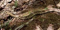

59 Some Amphibean and Reptile Photographs Red eft Red-backed salamander Spotted salamander eggs Spring peeper Wood frog Pickeral frog American toad Green frog Bull frog Garter snake Maritime garter snake 55
THE INTERNATIONAL APPALACHIAN TRAIL IN MAINE
 THE INTERNATIONAL APPALACHIAN TRAIL IN MAINE INTRODUCTION The Maine section of the IAT/SIA is 130 miles (211kms) long. Heading north from the Katahdin Lake East (KLE) Access trailhead of Baxter State Park,
Alpine Glacial Features along the Chimney Pond Trail, Baxter State Park, Maine
 Maine Geologic Facts and Localities September, 2009 Alpine Glacial Features along the Chimney Pond Trail, Baxter State Park, Maine 45 54 57.98 N, 68 54 41.48 W Text by Robert A. Johnston, Department of
C E N T R A L C A T S K I L L S
 120 C E N T R A L C A T S K I L L S Central Catskills Once out of the southern parts of the Catskills, the Long Path enters the more well traveled and civilized regions. The trail joins the Devil s Path,
beach. Make the ford and follow the trail out to the junction with Red Creek Tr in an open grassy area.
 Description: This is a moderate to slightly strenuous 22.8 mile backpack (add 2.6 miles if you do the packless out and back to the Lion s Head) that will have you exploring nearly every thing that is The
Suggested Day Hikes. Mount Greylock State Reservation 3, 4 1, 2. Take a Hike! Things to remember:
 Suggested Day Hikes Mount Greylock State Reservation Take a Hike! This guide offers suggested day hike routes in two parts: 1) Year-round Hikes and 2) Seasonal Hikes (late-may to Nov.1). Use this guide
Marilla Reservoir to Chestnut Ridge via Marilla Trails and Bullis Hollow Trail east to west
 USGS topographic maps useful to this hike are the Bradford and Stickney 7.5 minute sectionals. These notes are designed to assist in identifying distance and location using geophysical and man-made characteristics
Stephens State Park Trails
 TRAILS OF ALLAMUCHY MOUNTAIN & STEPHENS STATE PARKS Allamuchy Mountain and Stephens State Parks contain 28 marked trails providing access to diverse landscapes for walking, hiking, biking, bird-watching,
CRAZY HORSE TRAIL GUIDE
 CRAZY HORSE TRAIL GUIDE Abridged Version: July 2016 This is a short form of our interpretive trail guide for the Crazy Horse Trail. The full version of the guide has a more detailed description of the
S H A W A N G U N K R I D G E T R A I L
 214 Shawangunk Ridge Trail The Shawangunk Ridge Trail was originally conceived as a relocation of the Long Path from Harriman State Park to Minnewaska State Park. Now part of the Long Path system, the
Rogue Gorge (Mt. Stella) Roadless Area-- T30S R3E (primarily in portions of Sections 23, 26, 33, 34 & 35)
 Roadless Area-- T30S R3E (primarily in portions of Sections 23, 26, 33, 34 & 35)") Rogue Gorge (Mt. Stella) Roadless Area-- T30S R3E (primarily in portions of Sections 23, 26, 33, 34 & 35) Rogue River-Siskiyou National Forest--High Cascades Ranger District Upper, higher elevation trail
Rogue Gorge (Mt. Stella) Roadless Area-- T30S R3E (primarily in portions of Sections 23, 26, 33, 34 & 35) Rogue River-Siskiyou National Forest--High Cascades Ranger District Upper, higher elevation trail
Trail Beginning Elevation: 7553 ft The Poison Creek Trailhead is located at the end of National Forest Road 646E (NF-646E).
.") West Mountain Trails Poison Creek Trail #134 Length: 2.9 miles (4.7 km) Difficulty Horseback: A good trail for the first time west mountain rider, some steep sections Hiking: Most Difficult USGS Maps:
West Mountain Trails Poison Creek Trail #134 Length: 2.9 miles (4.7 km) Difficulty Horseback: A good trail for the first time west mountain rider, some steep sections Hiking: Most Difficult USGS Maps:
GOLDEN EARS PROVINCIAL PARK
 GOLDEN EARS PROVINCIAL PARK Trail Information as of October 10 th 2015 Do not underestimate the mountainous wilderness of Golden Ears Provincial Park. The combination of rugged terrain and rapidly changing
GIFFORD PINCHOT NATIONAL FOREST
 GIFFORD PINCHOT NATIONAL FOREST 9341 Wright Meadow 93 Spencer Meadow Spencer Butte 4247' 30 30A 19 24 80 31C Lewis River Lower Falls 5 Quartz Creek 90 Taidnapam Falls Upper Falls 31 Spencer Peak 3861'
Mount Katahdin in Maine
 Bangor Public Library Bangor Community: Digital Commons@bpl Books and Publications Special Collections 1930 Mount Katahdin in Maine Bangor and Aroostook Railroad Follow this and additional works at: http://digicom.bpl.lib.me.us/books_pubs
Did It. naturalists. Young. Moving and melting ice shaped many of Minnesota s land features. 30 Minnesota Conservation Volunteer
 Young naturalists by Mary Hoff Photography by Gary Alan Nelson T he Glacier Did It Moving and melting ice shaped many of Minnesota s land features. Shut your eyes. Imagine that it s a sunny summer day
ESTABLISHMENT OF THE KATAHDIN WOODS AND WATERS NATIONAL MONUMENT BY THE PRESIDENT OF THE UNITED STATES OF AMERICA A PROCLAMATION
 This document is scheduled to be published in the Federal Register on 08/29/2016 and available online at http://federalregister.gov/a/2016-20786, and on FDsys.gov ESTABLISHMENT OF THE KATAHDIN WOODS AND
Androscoggin River Trail Access Sites. North Woods. 168 miles from its source at Lake Umbagog to Merrymeeting Bay
 Androscoggin River Trail Access Sites North Woods 168 miles from its source at Lake Umbagog to Merrymeeting Bay Trail Under Construction More than 40 Public Access Sites Available Androscoggin River Watershed
2.1 Physical and Biological Description Matabitchuan River Watershed
 2.1 Physical and Biological Description Watershed 2.1.1 Physical Description The system watershed has a total area of about 933 km 2 and is a tributary system to Lake Temiskaming and the Ottawa River Drainage
Crystal Lake Area Trails
 Lake Area Trails Welcome to the Lake area of the Big Snowy Mountains! This island mountain range in central Montana features peaks reaching to 8,600 feet and long, high ridges from which vistas of the
F.O.K.O.S. Friends of Kingston Open Space A GUIDE TO KINGSTON OPEN SPACE
 F.O.K.O.S. Friends of Kingston Open Space A GUIDE TO KINGSTON OPEN SPACE Friends of Kingston Open Space (FOKOS) was formed when a handful of concerned citizens joined together to learn what could be done
Segment 2: La Crescent to Miller s Corner
 goal of the USFWS refuges is to conserve, protect and enhance fish, wildlife and plants and their habitats for the continuing benefit of the American people. Refuge lands are used largely for fishing,
The gorges of Mohican Park in Ohio create a hiker's paradise Sunday, May 22, 2011 By Bob Downing, Akron Beacon Journal
 Pittsburgh Post-Gazette The gorges of Mohican Park in Ohio create a hiker's paradise Sunday, May 22, 2011 By Bob Downing, Akron Beacon Journal Bob Downing Big Lyons Falls drops 80 feet into a shady U-shaped
Non-motorized Trail Plan & Proposal. August 8, 2014
 Town of Star Valley Ranch, Wyoming and the Star Valley Ranch Association in partnership with the USDA Forest Service, Bridger-Teton National Forest, Greys River Ranger District Non-motorized Trail Plan
Lidar Imagery Reveals Maine's Land Surface in Unprecedented Detail
 Maine Geologic Facts and Localities December, 2011 Lidar Imagery Reveals Maine's Land Surface in Unprecedented Detail Text by Woodrow Thompson, Department of Agriculture, Conservation & Forestry 1 Introduction
MP : Headwaters of the Fraser River
 MP 236 237: Headwaters of the Fraser River The mile between these two mileage posts is often just referred to as the bottom switchback or the curve at the bottom of Berthoud Pass. For many locals this
Note: Coordinates are provided as Universal Transverse Mercator UTM Zone U21, North American Datum 1983 (NAD 83).
.") Northern Traverse Route Description The Northern Traverse (formerly the North Rim Traverse) is an unmarked and rugged backcountry hiking route. It is known be a demanding hike, because of its terrain and
Northern Traverse Route Description The Northern Traverse (formerly the North Rim Traverse) is an unmarked and rugged backcountry hiking route. It is known be a demanding hike, because of its terrain and
KETTLEBOWL - Distance: Approximately 13 miles Highway 52 to Polar at Highway 64.
 LANGLADE COUNTY ICE AGE NATIONAL SCENIC TRAIL CONDITIONS (As of September 7, 2017) Due to situations beyond the control of the Langlade County Chapter of the Ice Age Trail Alliance, conditions are constantly
Community Listening Sessions Report of Input
 National Park Service Katahdin Woods and Waters National Monument Community Listening Sessions Report of Input Prepared by Leigh Tillman Facilitation September 15 th - 29 th, 2016 Stacyville, East Millinocket/Medway,
A Publication of Friends of Sleeping Bear Dunes
 A Publication of Friends of Sleeping Bear Dunes 2014, Friends of Sleeping Bear Dunes, P.O. Box 545, Empire, MI 49630 www.friendsofsleepingbear.org info@friendsofsleepingbear.org Learn more about the Friends
9 December 2016 Maxwell Wolckenhauer NYS DEC State Highway 10, Suite 1 Stamford, NY Conservation.
 Conservation Education Recreation Since 1922 9 December 2016 Maxwell Wolckenhauer NYS DEC 65561 State Highway 10, Suite 1 Stamford, NY 12167 r4.ump@dec.ny.gov RE: Windham-Blackhead Range Wilderness UMP
LANGLADE COUNTY ICE AGE NATIONAL SCENIC TRAIL CONDITIONS
 LANGLADE COUNTY ICE AGE NATIONAL SCENIC TRAIL CONDITIONS (As of September 1, 2014) Due to situations beyond the control of the Langlade County Chapter of the Ice Age Trail Alliance, conditions are constantly
1.4 Understand how moving ice acts as an agent of erosion and deposition. (Chap. 2)
") 1.4 Understand how moving ice acts as an agent of erosion and deposition. (Chap. 2) There are two types of glaciation. Alpine Glaciation Continental Glaciation Distinguish between the terms alpine glaciation
1.4 Understand how moving ice acts as an agent of erosion and deposition. (Chap. 2) There are two types of glaciation. Alpine Glaciation Continental Glaciation Distinguish between the terms alpine glaciation
Tiger Mountain State Forest:
 98 60 hikes within 60 miles: SEATTLE 20 Tiger Mountain State Forest: West Tiger Mountain Three Loop i KEY AT-A-GLANCE INFORMATION Length: 5.1 miles round-trip Configuration: Loop Difficulty: Moderate difficult
Massanutten Mountain Cluster
 Massanutten Mountain Cluster Signal Knob Catback Mountain Southern Massanutten Mountain Five areas of almost 49,000 acres on the Lee Ranger District compose the Massanutten Mountain Cluster of Mountain
Other Agencies and Organizations
 Daniel Boone National Forest 1700 Bypass Road WInchester, KY 40391 859-745-3100 Location Northern terminus is near Morehead, Kentucky. Southern terminus is located in the Big South Fork NRRA in Tennessee.
Fort Ticonderoga Carillon Battlefield Walking Trail Guide
 Fort Ticonderoga Carillon Battlefield Walking Trail Guide Copyright Fort Ticonderoga. Photo Credit Carl Heilman II Length: Approximately 1¾ mile Welcome to Fort Ticonderoga s Walking Trail Blue markers
playwinterpark.com Off The Beaten Path Hikes Hiking Recommendations for the Adventurous Hiker
 playwinterpark.com Off The Beaten Path Hikes Hiking Recommendations for the Adventurous Hiker Hike: Devil s Thumb (difficult) Length: 3.93 miles one-way Elevation: Trailhead 9609 Destination 12,236 Trailhead
H U D S O N P A L I S A D E S
 14 H U D S O N P A L I S A D E S Hudson Palisades The southernmost sections of the Long Path follow the Hudson River and the Hudson Palisades north, staying close to the river and to civilization. Although
The Superior and Des Moines lobes largely shaped Polk and Burnett counties.
 olk & Burnett Counties Trail miles: 57.1 Connecting route miles: 7.3 The Superior and Des Moines lobes largely shaped olk and Burnett counties. First, the Superior Lobe came from the northeast. Later,
Arches of the. Sandflats Area. By Virginia Allen
 Arches of the Sandflats Area By Virginia Allen TABLE OF CONTENTS Introduction Dedication Road Log Arches 1. Perforated View Arch 2. Fee Booth Arch 3. Windsong Arch 4. Weird Arch 5. Resting Arch 6. Bike
Big Cook s Pond Cottage Management Plan. Environmental Assessment Registration
 GOVERNMENT OF NEWFOUNDLAND AND LABRADOR Department of Environment and Conservation Lands Branch, Land Management Division Big Cook s Pond Cottage Management Plan Environmental Assessment Registration 1.
Location: Height: Access: Distance: Elevation: Season: Difficulty: Lat/Long: Directions:
 Upper Eagle Falls Upper Eagle Falls (~20 ft.) is a short hike up from the roadside at the Eagle Falls picnic area. It is very difficult to get a parking spot here during the day, so it is recommended to
Self-Guided Walk Langdale Pikes. Start & Finish: NT car park (free to members) at Sticklebarn - on the right just beyond the New Dungeon Ghyll hotel.
 at Sticklebarn - on the right just beyond the New Dungeon Ghyll hotel.") Self-Guided Walk Langdale Pikes Key Information These mountains form a collection of spires and cliffs on the north side of Langdale. This walk visits four of the main tops Pavey Ark, Harrison Stickle,
Self-Guided Walk Langdale Pikes Key Information These mountains form a collection of spires and cliffs on the north side of Langdale. This walk visits four of the main tops Pavey Ark, Harrison Stickle,
Black Hill Regional Park, Little Seneca Lake
 Black Hill Regional Park, ittle Seneca ake ittle Seneca ake, in Black Hill Regional Park, is a reservoir created after a previous drought struck the Washington area. The park is under Maryland-National
CIEC 9 PEAKS AWARD SUPPLEMENT POSSIBLE ROUTES FOR THE 9 PEAKS AWARD TRIP
 CIEC 9 PEAKS AWARD SUPPLEMENT POSSIBLE ROUTES FOR THE 9 PEAKS AWARD TRIP As you plan your trip, be aware of 3 regulations in this wilderness: 1. Camp only in designated campsites. 2. No campfires allowed.
REGISTRATION PURSUANT TO SECTION 6 OF THE ENVIRONMENTAL ASSESSMENT ACT. International Appalachian Trail Newfoundland & Labrador Chapter Inc.
 REGISTRATION PURSUANT TO SECTION 6 OF THE ENVIRONMENTAL ASSESSMENT ACT NAME OF UNDERTAKING: International Appalachian Trail Newfoundland & Labrador (IATNL) PROPONENT: International Appalachian Trail Newfoundland
East Branch Medway River Route 21
 East Branch River Route 2 This route is NOT recommended for NOVICE and INTERMEDIATE paddlers The route is comprised of the East Branch of the River, the River proper, and Port. Although there are a number
Driving Time: 3 hours (allow extra time for stops)
") Scenic Byways loop This journey takes visitors through the eastern edge of Mt. Rainier National Park and along two of Washington s most beloved scenic byways, the Chinook Byway and the White Pass Scenic
Scenic Byways loop This journey takes visitors through the eastern edge of Mt. Rainier National Park and along two of Washington s most beloved scenic byways, the Chinook Byway and the White Pass Scenic
The Physical Geography of Long Island
 The Physical Geography of Long Island A Bit About Long Island Length 118 miles Brooklyn to Montauk Geo202 Spring 2012 Width 23 miles at it s widest Area 1,400 square miles Formation of Long Island River
APPENDIX D: SUSTAINABLE TRAIL DESIGN. APPENDICES Town of Chili Parks and Recreation Master Plan Update
 APPENDIX D: SUSTAINABLE TRAIL DESIGN APPENDICES Town of Chili Parks and Recreation Master Plan Update Sustainable Trail Construction Sustainable trails are defined by the US Forest Service as trails having
Beaver Creek State Park
 GENERAL INFORMATION Name of Park/Forest/Facility: Beaver Creek State Park County: Columbiana (St. Clair Township) Address: 12816 Sprucevale Road (ie County Rd 428) (street #, city) East Liverpool, Ohio
Glacial Geomorphology Exercise
 James Madison University Field Course in western Ireland Glacial Geomorphology Exercise 3-day road log (abbreviated) Striations Large kame terrace Cirque with moraines Kame delta Striations Eskers Raised
Guthega to Mt Twynam. 2183m. 1583m. 6 hrs 45 mins 14.8 km Return. Experienced only. 913m
 Guthega to Mt Twynam 6 hrs 45 mins 14.8 km Return Experienced only 5 913m This walk starts from Guthega and makes its way along the Snowy River to the Illawong Lodge, via the Blue Cow Creek flying fox.
LANGLADE COUNTY ICE AGE NATIONAL SCENIC TRAIL CONDITIONS (As of May 18, 2017)
") LANGLADE COUNTY ICE AGE NATIONAL SCENIC TRAIL CONDITIONS (As of May 18, 2017) Due to situations beyond the control of the Langlade County Chapter of the Ice Age Trail Alliance, conditions are constantly
LANGLADE COUNTY ICE AGE NATIONAL SCENIC TRAIL CONDITIONS (As of May 18, 2017) Due to situations beyond the control of the Langlade County Chapter of the Ice Age Trail Alliance, conditions are constantly
ABOUT THE PARKS NANTAHALA NATIONAL FOREST MOUNTAINS NATIONAL PARK CHEROKEE NATIONAL FOREST PISGAH NATIONAL FOREST GREAT SMOKY HIKING TRAILS
 ABOUT THE PARKS GREAT SMOKY MOUNTAINS NATIONAL PARK NANTAHALA NATIONAL FOREST CHEROKEE NATIONAL FOREST PISGAH NATIONAL FOREST GREAT SMOKY MOUNTAINS NATIONAL PARK Straddling the border between North Carolina
Lake Wissota Access Locations within the LaFayette Township. By Chad Martin
 Lake Wissota Access Locations within the LaFayette Township By Chad Martin Anson/ Wissota Access Point # 1 Road: 195 th St. Associated Fire Numbers: 13294 Defining Characteristics: Forested from road
Camping (Primitive) Camping (RV) Electrical Potable Water Grill Established Fire Pit Picnic Table
 Camping (RV) Electrical Potable Water Grill Established Fire Pit Picnic Table") Alden - 9th Road River Mile 777 Map: 38.20833, -98.32031 Managing Agency: Kansas Department of Wildlife, Parks & Tourism Nearest Community: Alden, Rice County Kansas Developed Amenities Provided Parking
Alden - 9th Road River Mile 777 Map: 38.20833, -98.32031 Managing Agency: Kansas Department of Wildlife, Parks & Tourism Nearest Community: Alden, Rice County Kansas Developed Amenities Provided Parking
Trail Phasing Plan. Note: Trails in the Clear Creek Canyon area (Segments will be finalized in the future to minimize wildlife impacts
 Note: Trails in the Clear Creek Canyon area (Segments 2 5 and a future JCOS connection) will be finalized in the future to minimize wildlife impacts Trail Phasing Plan P Parking 3 Easy Trail Intermediate
Route #2) Mt. Massive - Southwest Slopes
 Mt. Massive - Southwest Slopes") Route #2) Mt. Massive - Southwest Slopes Difficulty: Class 2 Ski: Advanced, D6 / R2 / III Exposure: Summit Elevation: Trailhead Elevation: Elevation Gain: Round-trip Length: Trailhead: County Sheriff:
Route #2) Mt. Massive - Southwest Slopes Difficulty: Class 2 Ski: Advanced, D6 / R2 / III Exposure: Summit Elevation: Trailhead Elevation: Elevation Gain: Round-trip Length: Trailhead: County Sheriff:
Saturday Hike - Hancock Loop & Out
 AMC August 3, 2015 Saturday Hike - Hancock Loop & Out 0 2487 ft 2007, Appalachian Mountain Club. All rights reserved. Notes Created by AMC White Mountain Guide Online wmgonline.org 1 Distance Time Elev
Hiking Trail Descriptions
 Hiking Trail Descriptions For ye shall go out with joy. And be led forth with peace. The mountains and the hills shall break forth before you in singing. And all the trees of the fields shall clap their
Listing of Campsites on the Manigotagan River
 Listing of Campsites on the Manigotagan River This document lists and describes the campsites along the Manigotagan River between Highway #314 and the government dock in the community of Manigotagan. The
c. 1 inch = 0.6 miles e. 1:100,000 f. 1:250,000 f. 1 inch = 4.0 miles
 High School Advance Geology Map Test 2014 Name Use the information on each map to provide the best answer to the questions. Fill in the bubble of the best answer on your answer sheet. Answer questions
Anderson Mt. Proposed Wilderness Additions to the Rogue-Umpqua Divide Wilderness-- T30S R3E (mostly) Sections 4 & 9, and T29S R3E Section 33
 Sections 4 & 9, and T29S R3E Section 33") Anderson Mt. Proposed Wilderness Additions to the Rogue-Umpqua Divide Wilderness-- T30S R3E (mostly) Sections 4 & 9, and T29S R3E Section 33 When the 35,701 acre Rogue-Umpqua Divide Wilderness was designated
Anderson Mt. Proposed Wilderness Additions to the Rogue-Umpqua Divide Wilderness-- T30S R3E (mostly) Sections 4 & 9, and T29S R3E Section 33 When the 35,701 acre Rogue-Umpqua Divide Wilderness was designated
MANAGEMENT DIRECTION STATEMENT June, 1999
 Thompson River District MANAGEMENT DIRECTION STATEMENT June, 1999 for Clearwater River Corridor (Addition to Wells Gray Park) Ministry of Environment Lands and Parks BC Parks Division ii Table of Contents
Ribbon Cliff - Ribbon Mesa text and photos by Charlie Hickenbottom
 Ribbon Cliff - Ribbon Mesa text and photos by Charlie Hickenbottom Looking for something a little different than Sage Hills or Saddlerock? Perhaps something a little wilder, a little less traveled? Look
Route #1) Mt. of the Holy Cross - North Ridge
 Mt. of the Holy Cross - North Ridge") Climbing 14ers can be very dangerous, please read the Mountaineering Safety Page and make sure you have a map+compass and can use them effectively, without the help of electronic devices. Route #1) Mt.
Climbing 14ers can be very dangerous, please read the Mountaineering Safety Page and make sure you have a map+compass and can use them effectively, without the help of electronic devices. Route #1) Mt.
Photographing Upper Peninsula Waterfalls
 Photographing Upper Peninsula Waterfalls Tod Poirier Freelance Photographer Photography is one of my passions. The following spread showcases several Upper Peninsula waterfalls. At times a single drop
This Passport: Revised October 20, 2017, EAM # Discovering the Trails of Webster, NY
 This Passport: Revised October 20, 2017, EAM #161923 Discovering the Trails of Webster, NY The Town of Webster invites you to explore and experience our diverse outdoor adventures! Here s your opportunity
Victoria Falls Lookout to Blue Gum Forest
 Victoria Falls Lookout to Blue Gum Forest 8 hrs Experienced only 13.8 km One way 5 112m This long day-walk follows a remote track down from Victoria Falls lookout, passing the waterfall, and into the Grose
Koroc River Palmer River Loop
 parkscanada.gc.ca Multi-Day Hiking Route Koroc River Palmer River Loop Torngat Mountains National Park T. Knight, Parks Canada 425000m.E. 64 15'0"W 30 64 10'0"W 35 64 5'0"W 40 64 0'0"W 45 63 55'0"W 50
PHONE WEB. Caribou Parks & Recreation, 55 Bennett Drive, Caribou ME (207)
") 1-17-19 All the reports that I have been hearing from all the Snowmobilers are the trails are in the best shape that they have seen at this time of year, this is true from the Southern Reaches of the County
1-17-19 All the reports that I have been hearing from all the Snowmobilers are the trails are in the best shape that they have seen at this time of year, this is true from the Southern Reaches of the County
2. Goals and Policies. The following are the adopted Parks and Trails Goals for Stillwater Township:
 D. PARKS AND TRAILS 1. Introduction Stillwater Township s population is relatively low, with most residents living on rural residences on large lots. The need for active park space has been minimal in
CELEBRATE WEST GREENWICH GEOCACHING THROUGHOUT WEST GREENWICH
 CELEBRATE WEST GREENWICH GEOCACHING THROUGHOUT WEST GREENWICH The West Greenwich Land Trust (WGLT) is sponsoring Celebrate West Greenwich, an event designed to celebrate the beauty and history of scenic
BRACEVILLE NATURE PRESERVE Introductions History Present Conditions Future Development Plans Implementation Strategies Statistics
 BRACEVILLE NATURE PRESERVE Introductions History Present Conditions Future Development Plans Implementation Strategies Statistics Introduction Braceville Nature Preserve is one of MetroParks largest preserves.
Oregon Section B - Page m
 Oregon Section B - Page 1 5 35000m 5 36000m 5 37000m 5 38000m 46 57000m 46 58000m Hwy5B - Interstate Highway 5 - mi 1716.4-4271 ft RD1717 - PCT departs paved Old Highway 99 - mi 1716.8-4357 ft PL1717 -
IAT NS CAPE BRETON - NORTH SYDNEY TO PORT HASTINGS (SOUTHBOUND)
") NORTH SYDNEY TO GRAND NARROWS - 61.4 KM WELCOME TO NORTH SYDNEY, CAPE BRETON ISLAND, NOVA SCOTIA! North Sydney is a major city with a CAPs (public internet access) & all amenities. Rollies Wharf Restaurant
NORTH SYDNEY TO GRAND NARROWS - 61.4 KM WELCOME TO NORTH SYDNEY, CAPE BRETON ISLAND, NOVA SCOTIA! North Sydney is a major city with a CAPs (public internet access) & all amenities. Rollies Wharf Restaurant
Notes. Section 1. Northville to Benson Trail follows Main Street S and Bridge Street W
 Mile Section Mile NPT Mileage Table Notes Section 1. Northville to Benson 0.00 0.00 Trail begins at arch on South Main Street in Northville. Register located in parking lot in rear. 0.03 0.03 Trail follows
OWNED LAND ACTIVITIES REPORT February 2012
 OWNED LAND ACTIVITIES REPORT February 2012 BULL RUN MOUNTAINS NATURAL AREA PRESERVE A tremendous number of projects are underway on the Preserve. Currently VOF is working with the Smithsonian Conservation
NECHAKO CANYON PROTECTED AREA
 NECHAKO CANYON PROTECTED AREA PURPOSE STATEMENT AND ZONING PLAN March 2003 1 Nechako Canyon Protected Area Purpose Statement and Zoning Plan The Nechako Canyon Protected Area (1,246 hectares) is located
Skiing and Snowshoes on Un-groomed Fernan Saddle Terrain
 Skiing and Snowshoes on Un-groomed Fernan Saddle Terrain Three ski or snowshoe routes are available from the Fernan Saddle Parking Lot which either do not cover routes ordinarily groomed for snow machine
Hike at Pico Blanco Labor Day Weekend!
 Hike at Pico Blanco Labor Day Weekend! The Pico Blanco Hymn Here among the trees majestic Pleasures you will find On the trails of Pico Blanco With your friends and mine Trail the Eagle ever onward This
Logan Canyon Hiking Trail Guide
 C a c h e V a l l e y V i s i t o r s B u r e a u Logan Canyon Hiking Trail Guide Monique Beeley Legend Trail Location Guide WASATCH CACHE NATIONAL FOREST WILDERNESS PAVED WATER TRAILHEAD 9 Logan River
MASTER PLAN EXECUTIVE SUMMARY
 Biscuit Run State Park Scottsville Road (State Route 20) Charlottesville, VA 22902 Biscuit Run State Park MASTER PLAN EXECUTIVE SUMMARY Department of Conservation and Recreation Division of Planning and
306 Ice Age Trail Guidebook : 200,000 compilation scale. February 3, Marsh. Glenbeulah. Greenbush. Sheboygan. Parnell. Segment.
 G MANITOWOC Existing Ice Age Trail, subject to change as it evolves toward completion FOND DU LAC Other Trail Unofficial Connecting Route (unmarked) County Boundary ublic or IATA Land Miles 0 1 2 3 4 Marsh
Kitimat. Pacific Inland Coast. Hiking Guide Kitimat, British Columbia, Canada
 Kitimat Pacific Inland Coast Hiking Guide Kitimat, British Columbia, Canada 2010-2011 Sites and Trails Emergency Call 911 Police - Fire - Medical 2 Welcome to Kitimat This information was produced to assist
Sunday / Monday - Osceolas
 AMC August 3, 2015 Sunday / Monday - Osceolas 0 1737 ft 2007, Appalachian Mountain Club. All rights reserved. Notes Created by AMC White Mountain Guide Online wmgonline.org 1 Distance Time Elev Change
(/ 12 (/ 18 (/ 18 (/ 12 (/ 51 (/ 14 Æ%106 Æ% 106 Æ% 213 Æ% 104 Æ% 89 Æ% 26 Æ% 73 Æ% 59 Æ% 138 Æ% 92 Æ% 26 Æ% 67 Æ% 11 Æ% 11 Æ% 11. Æÿ H Æÿ Z.
 WAUKESHA Existing Ice Age Trail, subject to change as it evolves toward completion Glacial Drumlin Rail-Trail 94 Ice Age Trail Rock, Walworth and Jefferson Counties Other Trail Unofficial Connecting Route
Camp Jack Wright PERMANENT ORIENTEERING COURSE (2004)
") Camp Jack Wright PERMANENT ORIENTEERING COURSE (2004) WHAT IS ORIENTEERING? The skill which enables a person to navigate with a map. In the competitive sport, the winner is the person who finishes in the
Camp Jack Wright PERMANENT ORIENTEERING COURSE (2004) WHAT IS ORIENTEERING? The skill which enables a person to navigate with a map. In the competitive sport, the winner is the person who finishes in the
Charnley Explorer June 24 - July 15, 2018 Bachsten Creek and the Charnley River. Second draft: 14 November 2017
 Charnley Explorer June 24 - July 15, 2018 Bachsten Creek and the Charnley River. Second draft: 14 November 2017 The best part of the original section one is now part of out Gibb Road Gorges trip. The dates
TRAILS WHERE TO FIND TRAILS IN NOVA SCOTIA
 TRAILs SIGNAGE Know the Signs............................ 44 WHERE YOU CAN RIDE Roads and Highways........................ 46 Designated Trails........................... 47 Established Trails...........................
Trekking at Peuma Hue
 Trekking at Peuma Hue Peuma Hue is a paradise for those who love hiking and trekking. A large variety of trails cross pristine forest, ancient rocks and stunning waterfalls with beautiful views over the
THE REGION LAKE SUPERIOR THE GITCHI-GAMI TRAIL & THE NORTH SHORE
 LAKE SUPERIOR THE GITCHI-GAMI TRAIL & THE NORTH SHORE 7 LAKE SUPERIOR: Water covers 70% of the earth s surface area, but only 3% of it is freshwater. Saltwater makes up 97% of the earth s water supply.
TREK THE ROCKIES ABOUT THE CHALLENGE TREK THE ROCKIES FOR HIGHLAND HOSPICE CANADA TREK DEMANDING
 TREK THE ROCKIES CANADA TREK DEMANDING ABOUT THE CHALLENGE The Canadian Rockies are justifiably world-famous for their magnificent scenery: the combination of impressive, jagged mountains, bright turquoise
VOLUME II APPENDIX F DETAILED PHYSICAL DESCRIPTION OF PROJECT RESERVOIRS AND LANDS
 VOLUME II APPENDIX F DETAILED PHYSICAL DESCRIPTION OF PROJECT RESERVOIRS AND LANDS THE CENTRAL NEBRASKA PUBLIC POWER AND IRRIGATION DISTRICT FERC PROJECT NO. 1417 PHYSICAL DESCRIPTION OF PROJECT LANDS
Main Range Walk - Charlotte Pass to Mount Kosciuszko
 Main Range Walk - Charlotte Pass to Mount Kosciuszko 9 hrs Hard track 21.9 km Circuit 4 920m This full day walk explores some of the greatest alpine country on offer in NSW. The walk grants views of Blue,
HIKING IN THE CANADIAN ROCKIES
 HIKING IN THE CANADIAN ROCKIES Distance Time Elevation y MORAINE LAKE TRAILS THE ROCKPILE 0.8 km (0.5 mi) 20 min 30 m (98 ft) Located adjacent to the Lodge, the short interpretive trail up the Rock Pile
Asheville & WNC Hikes
 Asheville & WNC Hikes Amazingly, we have 3,000+ miles of free public hiking trails near Asheville, including 1,600 miles in the Pisgah and Nantahala National Forests, 850 miles in Great Smokey Mountains
President Roosevelt and Naturalist John Burroughs at Fort Yellowstone. Ruined Castles of Yellowstone. East Entrance Station
 President Roosevelt and Naturalist John Burroughs at Fort Yellowstone Ruined Castles of Yellowstone East Entrance Station President Roosevelt at Liberty Cap Yellowstone Lake, Mary s Bay Fire Hole River
Geologic Trips, Sierra Nevada
 ISBN 0-9661316-5-7 GeoPress Excerpt from Geologic Trips, Sierra Nevada by Ted Konigsmark All rights reserved. No part of this book may be reproduced without written permission, except for critical articles