Community Listening Sessions Report of Input
|
|
|
- Ferdinand Stanley
- 6 years ago
- Views:
Transcription


1 National Park Service Katahdin Woods and Waters National Monument Community Listening Sessions Report of Input Prepared by Leigh Tillman Facilitation September 15 th - 29 th, 2016 Stacyville, East Millinocket/Medway, Millinocket, Orono/Bangor
2 Table of Contents Introduction... 1 Question One What Makes This Place Special to You and How Do You Use It?... 2 Stacyville September 15 th... 2 East Millinocket/Medway September 20 th... 6 Millinocket September 22 nd... 7 Orono/Bangor September 29 th Question Two What Are the Opportunities/Ideas You See for Your Community and the Future of the New National Monument? Stacyville September 15 th East Millinocket/Medway September 20 th Millinocket September 22 nd Orono/Bangor September 29 th Question Three What Topics/Issues Are You Concerned About or Have Questions About That You Would Like to See Explored Further as Part of the Management Plan Process? Stacyville September 15 th East Millinocket/Medway September 20 th Millinocket September 22 nd Orono/Bangor September 29 th Our Hopes Going Forward Stacyville September 15 th East Millinocket/Medway September 20 th Millinocket September 22 nd Orono/Bangor September 29 th Appendix A: Community Listening Sessions Agenda Appendix B: Breakout Group Maps Appendix C: Community Listening Sessions Input Form Appendix D: Comments from Input Forms and Written Comments from Participants 61 Appendix E: Additional Correspondence... 66
3 Introduction In September 2016 the National Park Service (NPS) held Community Listening Sessions to collect community input about the Katahdin Woods and Waters National Monument (KAWWNM). The Listening Sessions were designed to accomplish the following objectives: To engage the community in helping shape the planning process that will be used to develop the management plan for the new National Monument; To learn from one another and to hear what community members see as the opportunities and concerns for the new National Monument; and To emphasize the significance of community involvement going forward in this planning process and to convey ways to be involved and stay connected. These Listening Sessions were the start of the conversation to hear from community members about their hopes, ideas, and questions for the future management of the Katahdin Woods and Waters National Monument. The Listening Sessions were held in the locations and on the dates listed below: Stacyville September 15 th East Millinocket/Medway September 20 th Millinocket September 22 nd Orono/Bangor September 29 th To ensure that the process was one where all views were heard and respected and where the time was used efficiently and effectively, the National Park Service brought in a neutral facilitator, Leigh Tillman, to help design, facilitate, and report on the Listening Sessions. Please see Appendix A for the Listening Session agenda. This report includes all input recorded during breakout group discussions, comments shared in the full group Our Hopes Going Forward discussions, written statements brought by participants (see Appendix D), and comments from Input Forms received by October 15 th (see Appendix D). Appendix E includes all other correspondence received during the time period of the Community Listening Sessions. Comments are captured in this report in the language in which they were written or shared. The National Park Service will use the input from the Listening Sessions to help identify topics and discussion items that will inform the engagement process for the management plan going forward, which will include additional community discussions and group meetings. Simultaneously, the National Park Service will be conducting resource studies about the natural and cultural history of the lands to Report of Input Prepared by Leigh Tillman Facilitation September 15 th -29 th,
4 supplement the work that has already been done around understanding what makes this place special. The National Park Service has committed to completing the management plan in three years. Question One What Makes This Place Special to You and How Do You Use It? To provide input on this question, participants placed dots on maps of the National Monument to identify places that are special to them (using yellow dots) and places they use (using red dots). Please see Appendix B to view the maps from all the Listening Sessions. The following comments were shared in response to this question. Stacyville September 15 th Its beauty and wildlife Animals and river Fishing Skiing Hiking Sightseeing Fiddleheading Drive through Leaf peeping Exploring Moose watching Berrying Kayaking and canoeing Stargazing Photography Camping Snowmobiling ATV Motorcycling Biking Pet inclusion Areas used often are red [and] yellow [dots] because they are also special, vice versa Katahdin Lake and connection between BSP and National Monument Shin Ponds (Lower and Upper) Grondin Road Report of Input Prepared by Leigh Tillman Facilitation September 15 th -29 th,
5 Kimball Pond All important (history of log cutting, connection to roads/bridges, built by local residents) Rivers themselves (paddling, etc.) SUP, canoe, kayak o EB, Seboeis, Wassataquoik Grand Pitch, Big Seboeis, Lunksoos Orin Falls Hiking/skiing trails/huts IAT Deasey Mountain/fire tower Barnard Mountain Mt. Chase Patten Stacyville Sherman Medway Grindstone Millinocket Fishing spots (kept secret) Snowmobiling Biking Hunting Entire E. Branch Penobscot, Seboeis R. Canoeing, hiking, camping, hunting, snowmobiling, fishing LIVE THERE Peace and quiet Special o Woods and peace o No gates How do you use it? o Hunting o Fishing o Blueberry picking o Canoeing o Camping Memories with family blueberry picking, berries/fiddleheads Exploration Accessible Hunting/fishing Swimming Worked in woods 45 years fished river every year Seboeis o Wants to see more areas open to public Seboeis River Picnic, tenting Used to visit when roads were open handicapped Report of Input Prepared by Leigh Tillman Facilitation September 15 th -29 th,
6 o Wants to see some roads made into dirt roads that are accessible Orin Falls and Grand Pitch special (along E. Br. River Corridor) o Now can only access by hiking a lot of older people who won t be able to access except by road Like to go but leery of getting in vehicle and getting out by dark 7-mile walk to falls long haul, rough road Would like to see areas opened up What is special to me is the history of the area of my family being able to hunt in the area in the past without restrictions Question asked about how Maine wardens would patrol ATV and snowmobiling special, hope to continue to ATV and snowmobile, maybe a corridor trail Hiking, used to fish in the area Hope to fish and picnic in the future Would like to see Loop Road opened to snowmobiling because views are outstanding Yellow dot [places that are special to participants]: o Matagamon Lake and Whetstone Falls, Lookout View, Bowlin o Entire east side and southern section (along Swift Brook Rd.), Grondin, Frenchville Road, Sherman Lumber Co. Road, American Thread Rd., Rte. 11, Stacyville Rd. Red dot [places participants use]: o Access to Shin Pond Rd. (roads listed above) o Bowlin Camps o ITS #83 + #85?? ATV access Hunt Farm Rd. state easement o Could ITS routes be used? Not sure because it s privately owned. Issue: street legal vehicles. We chose to live here Quiet Nature at peace Was free access for hunting and fishing Scenery Best view into Katahdin Wassataquoik Stream most pristine fishing good Good skiing Good hiking Biking good Snow sledding good Use Baxter State Park My house area I use and is special Hiking, fishing, photography, bird hunting, canoeing, wildlife viewing, bird watching Job with Huber Report of Input Prepared by Leigh Tillman Facilitation September 15 th -29 th,
7 Boy Scouts down East Branch Matagamon High 40 years of troop trips Region is important Allagash Wilderness Waterway Brook trout Cottages on Lower Shin Pond, don t want anyone else there Paddling East Branch 20 years in Montana, and when homesick, it was the East Branch that I missed. Technical, beautiful. Looks like it did 20 years ago. Seboeis is amazing for paddling Snowshoeing adventures on Peaked Mt. Mushrooming Fiddlehead foraging Fly fishing on Wassataquoik Just the fact that it is being protected makes it special and more attractive to live in Friends like to hike IAT Whetstone. Wildlife and environment that is there. o Trees, water, landscape Traveler Pond Messer Pond The Lookout very special to whole group Haskell Rock Beauty of the area Lunksoos river and fiddlehead Whetstone Falls camping put in river Upper and Lower Shin Pond canoeing, boating, swimming, snowmobiling Bowlin Camps snow sledding, camping, fishing Sugarloaf Mt. hiking, climbing Mt. Chase climbing, waterfalls Matagamon cross-country skiing Wassataquoik fishing, camping Barnard Mt. views, climbing, great trails We grew up near the Monument. The beach abuts some private property. We like to hunt and hike Patten is writing a comprehensive plan to get more of a vision based upon the Monument I m a kayaker, we like to hunt and fish The Park has always been like a private park and now change is coming Bear baiting business is lost. Worried about changes. Lumbering history is important, big river drives Report of Input Prepared by Leigh Tillman Facilitation September 15 th -29 th,
8 East Millinocket/Medway September 20 th Hiking trails Orin Falls Remoteness Access to Park (viewshed) Lunksoos (boat launch access and fiddlehead) Whetstone (beautiful) Snowmobile/4 wheeler Camping spots Bowlin Camps, Grand Pitch, Ox Bow Appalachian Trail Wildlife along the trails very important, remoteness Grindstone Important to access area to get people out if hurt Will roads be maintained on west? Canoeing with the Boy Scouts We worry about losing access to places like Bar Camp Meadow off ITS 85 We will lose access to views that are inaccessible without a snowmobile Opportunities for hiking in remote areas An intact ecosystem Minimal development How will access influence the volume of people who visit? How can we take advantage of this opportunity to bring an economic boost to the local communities? Special o Whetstone o Katahdin Loop scenic view o East Branch Penobscot R. o Camp on National Monument land Use o Whetstone Falls o Moose BK Falls o East Branch Penobscot R. o Concerned about litter on river o Concerned about restricted use o Concerned about the assumption that river belongs to KAWWNM o Going to get worse o Maintain heritage of river This place is for everyone Girls in wilderness therapy o Monument a soul-resting place Monument land is his backyard Everyone should have something to do with this Monument Fiddleheading, fishing, canoe trips, putting in Lunksoos or the Brackett Store on Grindstone Road Report of Input Prepared by Leigh Tillman Facilitation September 15 th -29 th,
9 Cutting wood, hauling wood on Kelloch Mountain Fly fishing at the Hulk. North Twin fishing, loves to fish and hunt. Snowmobiling out of Millinocket and access. Keep existing snowmobile trails open. Hiking Barnard Mountain. Hiking, driving Loop Road ATV Picnic, camping Wassataquoik Stream, East Branch, and Seboeis kayaking Timber harvest and good forest management Logging camps that are 100 years old at Scraggly Lake limited access, hike, biking, fishing, kayaking, listen to loons. Hope Monument brings peace to others. Camped at parks and lakes campground. Fishing, Bowlin Camps, Matagamon all the way to Peaked Mt. How can you separate what s special and what you use? Lost a close friend on Grand Pitch Reg. Maine Guide take sports hunting, fishing, photo trips Want to pass on traditional uses It s here we need to make it successful Seboeis section very special. Been running for 20 years. Wanted to see what everyone thought Spent whole life in parcels on west side as kids Straggly Lookout, lots of biking Used to be you could only access some ponds by plane Keep northern portion wild Millinocket September 22 nd Lookout view out of Bowlin Camps Grand Pitch Hiking, snowmobiling, explore East Branch Penobscot entire corridor Wassataquoik Stream by Katahdin Brook ( ) Loop Road o Ride around o Picnic o Hike IAT Ride the Loop Road Scenic overlook Picnic Sand Bank campsite Appreciate the scenic drive vistas Report of Input Prepared by Leigh Tillman Facilitation September 15 th -29 th,
10 Wild parts Blank spots Orin Falls Waterfalls 1-2 mile hikes User friendly trails Whetstone Falls camping Orin Falls very beautiful Access to river o Whetstone Loop Road o Short trails (access) Viewsheds o Provide more viewpoints Elderly accessibility (ADA +) o Transportation services? Small primitive campsites o Katahdin Brook Wassataquoik Stream Better access to Lookout view Reestablish same old road systems Road access along Wassataquoik Stream o Older crossing? o Snowmobile trail Bike trails Horse trails (carriage roads) Paved roads (spectrum: primitive to urban) Whetstone boat launch go down river Wassataquoik/East Branch history and beauty Stacyville Road hunting access Whole area for (heater) hunting and fishing off road bikes Bowlin Camps snowmobiling Orin Falls to fish Whetstone Falls sightseeing/picnicking/fly fishing/camping lean-to Lunksoos canoe history of Donn Fendler Scenic overlook artist s view Lookout x-country ski Wassataquoik Bridge beauty Katahdin Lake timeless quality Grand Lake Matagamon beautiful Stair Falls artists spot Upper East Branch rapids Old growth forests On way to Deasey most beautiful old growth forest Peacefulness Report of Input Prepared by Leigh Tillman Facilitation September 15 th -29 th,
11 East Branch my dad s camp was there Jack Robinson s camp is there Cultural history Mill and logging history Picnicking, rafting, hiking along Park Loop Road Home Long history of experiences in area Wild and undeveloped (relatively) Wildness is what makes it unique Photography Deasey Mountain, Wassataquoik Stream Canoeing East Branch, Matagamon, Whetstone River driving history Hunting and fishing along Sherman Lumber Company Road Potential the new Monument has for a new vision of the area Mountain biking along Loop Road and road to Orin Falls Backpacking, IAT access Used in the past pick berries, fiddleheads, hunting o Continued traditional use of the area general use o Specific fiddleheads, berries area o Harvested fruit keep that open Access to land within the Monument and without the Monument boat launch at Lunksoos Difference between growing up (fiddleheads) o Harvesting what can be gathered to be kept for personal use? Special quiet places irony of opening up places that were special because they were little used Educational experiences soul resting space Snowmobiling where is there access traditional in the east side available in west side o North/south snowmobile corridor guaranteed? Connectivity use to Patten? Matagamon? Millinocket? East? Shin Pond? Groomers? Mountain bike trails Hiking and camping Room for campers Fishing with boat and motor Special because generations of family have been there Don t know what to expect/how use/access will change Access up Lake Road to Katahdin Fiddleheads and berry picking Whitewater rafting (commercial use authorization) o (Canoe) Limit on number of cars in Park at one time Priority on reservations for campground or first come first serve Wassataquoik learned to whitewater canoe Report of Input Prepared by Leigh Tillman Facilitation September 15 th -29 th,
12 Bowlin Camps 4-wheel in area moose hunt Barnard Mountain History of old city new city The view vista Canoe trips on East Branch Lunksoos camp Fiddlehead picking Boy Scouts in area Sandbank Brook brook trout fishing Orono/Bangor September 29 th East Branch whitewater paddling o Canoe camping o Multiday o Whitewater Skiing the Wassataquoik Whole west side of river o Haskell Hut Katahdin Loop mountain biking Whole river makes living Barnard Mt. Trail vistas of undeveloped land and Katahdin Loop Road campsites International AT bike trips Specifically Lunksoos undeveloped o Mountain bike to beautiful vistas Remote hiking and camping WITH MY DOG! Fishing, hunting, hiking, ATV, snow-sled throughout Landscape of East Branch and geologic setting undeveloped landscape Sea Fury Crash Site historic interest * HARD to pick out isolated locations which are special Big emphasis on river use o Canoeing, kayaking o Water recreational use generally Is there a business opportunity related to the river? Geologic features of river Native American history on river needs to be recognized Good complement to Baxter water use, while Baxter is more mountains Good non-motorized multiuse area Cultural history is important o Timber history o Land holdings, timber companies Quiet place to get away Report of Input Prepared by Leigh Tillman Facilitation September 15 th -29 th,
13 Special because opportunity to develop new uses, like mountain biking Blank slate Scenic beauty Hiking Artist inspiration Night sky Rivers canoeing, Haskell Rock Wassataquoik/Katahdin Brook o Fishing, fiddleheading Seboeis River Bridge Loop Road Katahdin Brook scenery East Branch Scouts canoeing Views Unique addition protected area network of U.S. Six sets of falls Wild nature of Grand Falls and lack of development Birds, wildlife, night stars, shorter hikes, not commercial and crowded Memories Wild brook trout, hope of salmon o An outstanding fishery Night sky (dark), IAT, no pavement Peaceful, tranquil, past skiing, looking forward to canoeing Wonderful place to camp, an astounding place to camp, somewhat secret, wonderful opportunity to share with others Haskell Rock geologically unique Uses guide service uses roads for tours, would like scenic float trips on river Hikes into remote pond (special place) Special East Branch for camping Wild watershed Wassataquoik Stream very special Blank areas and wild areas very special once it s re-wild Visited all over the property (left unmarked) E. Branch special start of guiding, still guides, runs dogsled trips Visited the whole area Special for wildlife/wetland/endangered species habitat Wilderness makes it special Visited roads hopes to stay wild Loves to snowmobile, visits E. Branch, wants to keep access for winter Lookout view is special (used to have snow-sled access) Hasn t used it, but loves the idea of wilderness Great woods but wants to move management to National Forest Matagamon entrance, skiing use Haskell Hut good place to rest for skiers Bowlin Camps great food lodge Report of Input Prepared by Leigh Tillman Facilitation September 15 th -29 th,
14 Grand Pitch road access area, good trapping and hunting and guiding, dog hunting Lunksoos Camps kayaking area, East Branch falls Deasey Mountain Fire Lookout great hiking area o Mile 7 and 8 Loop Road Recreation hiking/views o Barnard Mountain hiking o Wassataquoik Ford o Orin Falls (bike trails) o Lunksoos Mountain Land management concern due to use in and around Park area Whetstone Bridge great views and access Lookout Mt. great views Continued access concerns Grand Pitch good fishing, scenery Stair Falls excellent whitewater Fiddleheading Idaho Pond mountain biking with single track near Sandy Stream with all ability levels of riding, scenically beautiful BSP special place Wassataquoik Stream scenically beautiful o Exceptional Atlantic salmon habitat o Moose Pond heritage brook trout pond Sandbank Stream brook fishing Haskell Deadwater brook fishing Destinations o Shin Pond Village o Bowlin Camps Matagamon Wilderness food stops Special area because lack of red tape allows diverse access and use Really good view of Mt. Katahdin scenic view spot painted Rivers extraordinary o National scenic river system significant o Canoe-ability kayaks Trails 1st 30 miles of IAT o Others East Branch possibly best in eastern U.S. o Section with falls and portages is largely inaccessible important Barnard Mt. Logging roads Encounter with lynx Cold water fish habitat Atlantic salmon, brook trout Historical value human involvement Orin Falls hiking Report of Input Prepared by Leigh Tillman Facilitation September 15 th -29 th,
15 E. Branch paddling kayak Barnard Mt. climbing views Burnt Land Pond cabin (cool) Sandy Stream views, totally WILD No Name Pond (Idaho Pond) remote mountain biking 24 mile loop Little Spring and Big Spring Brooks hiking, fishing Awesome stretch of whitewater Upper East Branch Lower Shin Pond small pond abundance of camps, great boating, swimming, fishing Seboeis River (Philpott Bridge) snowmobile corridor major Lower Wassataquoik whitewater (outdoor education for kids) Katahdin Lake hiking/scenic Twin Ponds hiking/scenic Seboeis, East Branch, Wassataquoik Rivers boating and scenic Question Two What Are the Opportunities/Ideas You See for Your Community and the Future of the New National Monument? Stacyville September 15 th Road system is not adequate, fix roads. Hot top roads. It will improve it. Real estate will improve Campground opportunities Looking for economic opportunities, federal jobs, guide service jobs, hunting, fishing, snowmobiling on east side of river. Cross-country skiing. Comprehensive plan to gain grants for businesses Increase in local business? New businesses moving in? Will there be good paying jobs moving in? Franchises allowed? Big jobs imported? Will local people be hired or will the larger paying jobs go to existing Park Service staff? More game wardens needed? Road construction and maintenance local or imported? Will families be able to settle here year-round? How will the local economy be boosted? o Emergency response teams o Lodging/restaurants/RV Park/campground Promote Patten/Stacyville/Sherman/Shin Pond area Report of Input Prepared by Leigh Tillman Facilitation September 15 th -29 th,
16 What are restrictions in a Park or Monument? Biking, canoeing, horseback riding, hiking Local businesses may benefit More access for snowmobiles o Increase of economic activity Shin Pond area as great access through Lower Shin All access from southern strip through Loop up along river Connecting road from north end to south end all access improve road Do we have the right to go there? o Have access to land Look at NPS rules to get ATV access North and south travel of ATVs and snowmobiles Opportunities for new businesses o Area for young people to stay here *Local employment* Use property and enjoy it Hate to see it overrun with hotel/motel/tourist traps Don t want things to change Mills are gone this is economic opportunity Want it to fit into the area Towns should look at their comprehensive plans Lost many of our children to southern area because we didn t have anything here for them To make life better for family and community Embrace the change, we re in this together, exciting o More places to get coffee and to shop Restore things in the area Share our history, already being done on a small scale Tourism maybe bring other opportunities Need diverse economy Question about the different areas of Monument how will access work? The gateway to more areas Jobs Opportunities with the school systems o A collaboration/internships for jobs o And education (field trips ) and how to get funding for this Make section available to handicapped (paved roads, scenic picnic areas) Educational opportunities (i.e. big dreams Schoodic Institute, small dreams too) Visit from further away than local area Employment (particularly for locals) Local small business employment Recreation including facilities/accommodations Young families brought to the area to stay Report of Input Prepared by Leigh Tillman Facilitation September 15 th -29 th,
17 Local advisory reps on board Inspire young people to come back and start businesses Law enforcement to cover area (response times) All voices heard, not just now but ongoing o Trying to bring together proponents/opponents o Addressing concerns even after designation Bring together all local communities Matagamon to Millinocket Lake Broaden our vision and worldview as a result of those visiting/coming in Bring employment (much needed) Tourists and tourist services Increase tax base (increase number low taxes) Allow timber harvesting Celebrate history of area Educate public More business opportunities National Forest versus National Monument Increase property values Bring more money into the area More lodging and restaurants to the area Better paying jobs More support for schools More support services (medical/anything) Access for schools, outdoor education Maine Natural Areas Program Increase traffic to area, stopping in towns on the way Places to stay/eat are seeing more patrons Guiding Concern want to avoid big box stores, chains, want to keep local stores, small town feel Quaint, remote experience in nearby towns is part of the experience of visiting the National Monument Want coordination with Maine town planning boards, Grow Smart Maine, for ordinance in place for smart, healthy downtown main streets. Local. Maine-made. Healthy growth, but keep small town feel. Keep local cultural heritage lumber, Penobscot history Embrace quality professionals because quality of life is high Increase doctors, surgeons, etc. because want to balance work/life Deep love for Lumberman s Museum, opportunity for support Support libraries Millinocket Library struggle Build on recreation economy through increased tourists, visitors What does it take to provide guide services in the National Monument? o Concern is that NPS puts additional requirements on guides o Concern is visitors (especially traditional visitors) would need to hire a guide to access land, water Report of Input Prepared by Leigh Tillman Facilitation September 15 th -29 th,
18 If bird hunting, can hunt with dog? Off leash? Jobs Future infrastructure serving people who visit School enrollment will increase Expanded tourism opportunities Influx of new residence Property value increase Local businesses and attractions (Lumberman s Museum) get more business Opportunities for our kids (so they don t have to move away) Increase in tax base Jobs Real estate Tourism River trips Guiding More opportunities for local business to grow More families with children in schools Might improve looks of town More activities for teens for recreation Increased aspirations of our youth More positive perspectives Economic stability More winter activity will boost tourism year-round Attract more diversity and new ideas New creativity Against it, so Same opportunities as in the past Now that mills closed (and Monument is a fact), some people changing minds Monument may provide jobs, reasons for young people to stay Could have been gated if EPI hadn t bought it Access won t be free (always has been free) Visitors will come May help us appreciate this land more It is (was) privately owned Preservation of natural resources Economic growth for local communities Facilities to accommodate visitors Educational opportunities Enhanced access and trail systems Increased property value Multiuse concept Report of Input Prepared by Leigh Tillman Facilitation September 15 th -29 th,
19 Lodging, gas stations, stores, opportunities but outside the Park boundaries only Economic development such as hotels, restaurants Craft shops, souvenirs, galleries Visitor centers ATV access. Not losing the trails on the Grondin and American Thread Roads. Great views of Katahdin. Concerned resident who lives on Happy Corner Rd. about eminent domain Concerned about accessing local deadwater on lands for fishing fiddleheading. Would there be an access fee in the future. Concerned about points where planning to invest significant funds in developing and improving huts. Being sure that all traditional uses stay as they ve been. Fear of developing on the lands and them staying as they are. Barnard Mt. in particular being just the way it is now. ATV access on lands east of the river the way it is deeded for snowmobiles. We need to be able to capitalize on the growing ATV market. East Millinocket/Medway September 20 th It could be a good destination spot for hunting, bird hunting Active forest management a must Good roads to get into the Monument easily New business growth in the surrounding communities Maybe a theme park (a moose theme park) People want to see moose Might help to manage if the land were more connected Have a visitor station in Medway Medway has a nice boat launch, maybe have more Improve the signs on the roads Is it going to allow motorhomes and 5th wheels Concerns about how to get people here to grow the business Tourism a strong economic driver Small Maine towns need diversity like small Maine farms A place to get away from the crowds Love the hiking Keep lower taxes, create jobs It s a chance to protect a wild area and protect the wilderness Balance commercialism with roadless area Increase economic opportunity Bring back the value of homes in the area Report of Input Prepared by Leigh Tillman Facilitation September 15 th -29 th,
20 Bring people into Medway, East Millinocket, Millinocket, Stacyville, and Patten A different kind of experience of the area than you do in Baxter SP Do we want to increase access for people who can t hike? Would a road from Matagamon down to the Whetstone ruin it? How much access for the handicapped? Access from Millinocket Tourism development Year-round attraction Environment education Restaurant/lodging Bus shuttles Visitor center Fishing tourism New industry Village theming Regional cooperation Guiding X-country skiing, biking, etc. (rental) Camping Wildlife Great opportunity for Medway NPS has offices in Patten and Millinocket but nothing in Medway. People need an information center near the major access roads. Love the church and view. Don t want to see exit look like all other exits. Keep town quiet. With influx of people there is opportunity. Need balance. Children had to leave. If there is a chance for kids to stay or return we have to see as a positive. Generational difference. Young people move away every day. Opportunities to keep them. Opportunity for towns to work together for regional development instead of towns competing Educational center of excellence. Visitor center with interpretive history, culture. Increase in revenue with more people coming to area Create jobs and opportunity Good institution to preserve history Hire local people for work Local opportunity Seasonal jobs are still good jobs Need a kiosk in every town More people coming in can bring in money to allow business to maintain and possibly expand Where does Report of Input Prepared by Leigh Tillman Facilitation September 15 th -29 th,
21 Opportunity for guides and lodging Local community to take advantage of tourist coming to KAWWNM You can have tourism and industry Opportunity for local guides Millinocket September 22 nd Opportunities for Boy Scouts/Girl Scouts o All outdoor recreation groups New business opportunities More opportunities for handicapped/elderly accessibility Job opportunities Development opportunities For Katahdin region to get back on its feet Partnership with investors NP and others Millinocket needs to be a gateway community Work with communities around the Monument We need what people want and need Access roads Hotel with a brand name Jobs Tourism Existing service centers join as a destination Open to exploration from south Opportunity to expand activities that are in Baxter Blending of region Complement to Baxter dogs/no dogs for example Part of an itinerary for visitors Bring industry name brands (Cabela s or outlet mall) Downtown looks like downtown Better place for kids level of safety, education, professionalism Festivals night sky ranger from NPS Local companies have opportunities to bid on jobs within development of Monument; i.e. Katahdin Cedar Log Homes bidding on cedar fencing or log buildings. Provide training on how to bid on NPS work Incubate, expand, develop a new small business area Community contribution Further improve recreational opportunities/that consider preserving landscape and user experience Local people want a say in how the area is marketed local ordinances will/may need to be adopted to manage growth and maintain character. Towns will need support for this. Report of Input Prepared by Leigh Tillman Facilitation September 15 th -29 th,
22 Town codes (building codes, etc.) need to be reviewed and updated sooner rather than later. Manage the development. Tell the story of forestry heritage Tell the story of the native people s heritage and include them in the management plan Winter recreation x-country skiing, snowshoeing, backcountry camping, winter motorsports, fat biking, climbing School trips A Friends of the Monument group needs to be established Would like to see a southern entrance to the Monument, located close to Millinocket important because hospital, airport, etc. are in Millinocket Interpretive center tells whole history of area and is high quality Connections and partnership with Lumberman s Museum Good for restaurants and businesses in the area Facelift for main thoroughfare into Park (what will community do to get ready for tourists) Town give tax incentives or programs for business owners to expand in response Where will entrance to Monument be? How will this affect communities? Want entrance through Millinocket Have more than one entrance Local landowners agree to access through private land? Personal histories and knowledge shared with audio recording Acadia 2+ million visitors (what is our opportunity?) Re-open public access (more than just walking) Educational opportunities for kids environmental science Job opportunities/growth for area Job multipliers recreation, other business draw people and interests in Communication with Penobscot Nation and connection with land Symbiotic relationship between both Parks Proper management between boundary BSP KAWWNM Maintaining view sites Well-rounded vacation area diversification Local business support with process and management (construction, amenities, etc.) Join Butler Foundation property with National Monument Long distance trails for x-country skiing Intentional/purpose-built recreational trail system (both humanpowered and motorized) Small business that builds signs to get contracts with the Monument, seminars for government contracting Opportunity for NPS to facilitate comprehensive planning regionally look at other gateway communities as models Report of Input Prepared by Leigh Tillman Facilitation September 15 th -29 th,
23 Loop Road developed/interpreted to be of interest, accessibility to all (including travelers who stay close to their cars non-wilderness explorers) On hunting/fish areas, opportunity for NPS to enhance those traditional uses (to offset areas where not allowed) Free day use for Mainers Moab a model for Katahdin region? Develop Seboeis River improve portages Natural plus amenities Tourism/ecotourism sustainable practices How to get people there but control impact Opportunity for Katahdin region to do regional planning, how to take advantage of economic and access development Revitalize communities while maintain area and culture Expand snowmobile/atv on east side o High quality/safe recreation i.e. parallel trails to support multiuse safely. Provide recreation and brings money to local communities. Jewels of Monument need to have access for people who might not be as mobile Carriage trail-type development bring in rich old people (ha, ha) Look at other National Monuments. Take the best ideas and bring them to KAWW. Real estate lots of infrastructure adaptive reuse and redevelopment Opportunity to preserve culture (interpretive) Monument should give preference local Opportunity for infrastructure/amenities outside of Monument property Community service project to get kids involved Kids art about Monument Want something good for Millinocket/attract tourism All we have going Keep it for future generations Building out trails and other recreational infrastructure Will trailers/rvs be allowed in campground (want allowed) Horse access/ trail riding Bike trails of different types (like carriage trails and also mountain bike trails) Prioritizing local businesses and concessions Orono/Bangor September 29 th A lot of economic development due to snowmobiling Pitfalls is sharing with the world Report of Input Prepared by Leigh Tillman Facilitation September 15 th -29 th,
24 Combine with BSP an extraordinary way to protect Wassataquoik Watershed Amazing story to tell Develop stories and histories of area Encryption Rock in BSP Canoe trip economic development and portages o Matagamon Stair Falls daytrip Guiding considerations Business inside the Monument A little bit less wild than Baxter Paved road but only one Access for handicapped and those less likely to venture off the trail Scenic bus rides Develop campsites, portage trails, and other river infrastructure Mitigate user conflict Work with surrounding communities on smart development Utilize existing surrounding infrastructure Businesses to support Monument users X-country ski destination Mountain bike destination Hut-to-hut travel (warming huts) Continued access from north to south for snowmobiles. Through travel within the Park. Keep current access as is. Involve locals. Concern about balancing increased automotive use with current worries about accidents. Concern for increased people flow to the southern entrance. What will the employment opportunities be? What prevents overdevelopment? Will logging be able to continue as is in the area due to new regulations? Will there be a way to alter access to the Monuments for guiding, hunting, trapping? Continued through access with off-road vehicles, bicycles, hiking, kayaking. Keeping a diverse array of recreational opportunities. Educational opportunities in varied means of access and signage Mass transportation as compared to Zion National Park Hope it to stay wild that s what makes it great. X-country skiing. Millinocket people united with Park and keep community involved. Wants trails and camping. As much multiple-use to allow next generation to fall in love with woods Outdoor education Tourism increased visitation surrounding communities Property value increases New people generate new ideas Accessibility to remote area Report of Input Prepared by Leigh Tillman Facilitation September 15 th -29 th,
25 Locals input to storytelling o History o Heritage o Culture o Peoples Foraging Artist programs Science/nature/environmental education Getting more children in the outdoors Scouting Focus brings focus for economic opportunity Facilities development for visitors/users Staging area, increased hotel stays Have an area east of Mississippi to see stars not even visible in Bangor Keeping the area without pavement Maintaining the IAT Science (what is there, what is changing) o Wildlife, history (including log drives) o Interpretation o Recreation Enjoy the silence Education Interpretation (human and natural history) Getting boys and girls out in nature Night sky Let each person access Monument as they wish (more accessible versus wilderness) Minimize (no) pavement no paved roads near East Branch; manage like Allagash Waterway limit visitors Understand Native American land ethic Build dialogue around how we treat land Learn about native land ethic Invite Wabanaki people to be involved A place for artists to use Understand how artists have seen and interpreted Jobs and diversity of jobs Opportunity for Katahdin region to refocus economic drivers Hope to see growth of creative economy and more millennials Beer, specifically craft breweries Beautiful, sustainable single-track bike/hike/run trails Interpretive visitor center, which includes logging/timber history and Native history Hut-to-hut x-country ski trail Report of Input Prepared by Leigh Tillman Facilitation September 15 th -29 th,
26 Reforestation plan Guiding customers through Park; rafting float trip Maintained x-country ski trails Mature forests in state of Maine; park services in community, keep services out of Park Whole Katahdin region should use this for regional land use planning to steer development to town centers. Develop services outside Monument. Currently no services, but work inner towns to visitors. Keep visitors coming to Millinocket. Work with local guides and outfitters to create more business. Don t put up paperwork and regulations. Could lose 5% of business. Beaver habitat unrestrained o Attracts and supports all wildlife Big opportunity for business nearby food, novelties, RV, lodge Opportunity to develop along with other sites in Maine o Acadia o St. Croix o Baxter Wide range of activities possible o Paddling, hiking, picnicking, photography, biking, hunting, fishing, snowshoe, painting Dogs allowed Less restricted than Baxter Establish walking/hiking trails (old logging roads) Schools natural history; ecology Park Service programs interpretation, heritage tours especially logging Campground inside (NPS)/ outside (private) Native history connection with Penobscot Nation Opportunity to have National Park/Monument that is less developed than Acadia, for example Monitoring climate change Shuttle service for canoe trips on E. Branch Support and protect and restore full range of native plants and animals Create a Friends of group FB page Access to north end People will come Folks may come up from Acadia Opportunity o Backcountry use o Windshield group Logging roads open up/cut/maintain for hikers, bikers making travel easier, quicker Report of Input Prepared by Leigh Tillman Facilitation September 15 th -29 th,
27 Additional protection for Baxter State Park Opportunity for jobs, educational opportunities (kids don t have to move to Ellsworth/Machias, etc.) Keep young people who are conservation-minded HERE!! Backcountry biking and camping o Single track biking opportunity Cross-country skiing system backcountry Mountain bike rentals Obvious business opportunities such as restaurant, lodging, etc. Continuous ATV access from Millinocket Swift Brook parcel north on the east side of the Penobscot to Shin Pond and beyond Ordinances, help with community planning Develop educational programs on ecology/conservation Interaction between Park personnel and schools Junior Ranger program Backcountry camping Connectivity of roads New campsites Question Three What Topics/Issues Are You Concerned About or Have Questions About That You Would Like to See Explored Further as Part of the Management Plan Process? Stacyville September 15 th The original goal was for approximately 150,000 acres. What is the current maximum size of the Monument/Park? Would it require congressional approval to go up to the 150,000 acres? How will access be maintained on private roads (Sherman Lumber Co. Rd. and Whetstone Bridge, for example)? Where will the main access point be for Monument users coming from the Patten area? Will logging trucks and campers still be allowed to use the Sherman Lumber Co. Rd. and Swift Brook Rd.? Taking of land by eminent domain Safety of logging vehicles and citizens Increased traffic speed Loss of woods workers production due to more traffic Seasonal or year-round tourism? Commercialize our forests Can a Monument become a part of the State Park? Report of Input Prepared by Leigh Tillman Facilitation September 15 th -29 th,
28 o What are the hunting/fishing restrictions? Will there be gate fees? Senior citizen fees? 70 and over free? Will there be tent sites? What will be the cost? Will the Monument management help us develop businesses surrounding the borders so we can benefit financially? We are not physically ready for an influx of people no hotels, not enough restaurants, tourist supports yet in place Plots of land for recreation not equal on both sides of Park Will there be a benefit (reduced or no fee) for Maine residents? Shin Pond Bridge safety. Truck off road because someone was stopped on bridge. Road safety multiusers, school buses Visibility, but what about light pollution? Night sky is a draw. How safety fits in? Police, ambulance, fire. Any plan on limit of visitors, use? Keep remote access on E. Branch? Want to keep remote experience in remote campsites. Have to balance with access via paved roads. Disabled accessibility. Don t want to impose on wilderness. Balance sightseers with rugged wilderness experience. Concern with nearby parking lot to Katahdin Lake. Currently takes work to get there. What about special interest groups dominating/changing the multiuse approach? Greeting center with log cabin type feel, fit in with what is Maine woods What is waste plan? Carry in carry out? Concern with Park access on Lower Shin Pond, is a boat ramp redundant? Are NPS planes going to be landing in Lower Shin Pond? Concern with ATV use only in Hunt Farm, currently Patten ATV Club is precluded from historically-used area around American Thread Road How will Maine Warden Service be compensated (in general), and managed if more monitoring is needed in KAWW? Same concern with Maine Forest Service? Who does what before management plan is implemented? Fisheries management plan Landscape fragmentation is a concern. Maintain continuity. Climate change adaptation. How does a person know when he/she is on a parcel of the Monument or on bordering land, given the number of parcels and amount of borders? o Example it would be easy for a bear hunter to cross onto Monument land without knowing How will access to Baxter be controlled through the Monument? o Katahdin Lake is an area much more easily accessed from the Monument Report of Input Prepared by Leigh Tillman Facilitation September 15 th -29 th,
29 Will Baxter visitors (with Baxter permits) be able to use the Monument to access Katahdin Lake area? What is the timing for changes in access during the transition to Monument land? o Example ATV access on Grondin Road How will access over Whetstone Bridge work if the owner doesn t want the Monument using it? (Will eminent domain be used here?) The increase in area of parks/concern about more land being added i.e. loss of timber harvest opportunity Safety for logging operations dealing with the public Increase in cost for operations because of slow downs work production Lack of signs on Rte. 11 S. concerns about Amish wagons Fire protection Community planning especially for nearby towns Support of museums, i.e. Lumberman s Matagamon Dam future? Concern for number of entrances stay like this? or reduce to one main? Handicapped accessibility for river and viewpoints Will new rules and regulations (esp. federal) come with Monument? Buffer zones for neighboring landowners? Access to Lower Shin for property owners Preserving Katahdin Lake area Concern for easement to Lower Shin Pond Composition of advisory board? Where main access is/visitor center? Road maintenance Eminent domain? Growth of Park? Use of American Thread Rd. consider use visitors would access through Patten ATV access Snow sled access Loss of current jobs (logging, outfitters, etc.) Will there be concessions in the Park? Will there be hotels? How developed? Traffic too much? Access to Baxter? Conservative use of water not too much boat activity Government rules and regulations beyond borders of Monument Access to Baxter needs control Invasive plants rock snot Infrastructure Patten not set up for large groups Report of Input Prepared by Leigh Tillman Facilitation September 15 th -29 th,
30 Watershed issues will there be restrictions placed on farming activity within a certain geographical distance? Matagamon Dam repairs going forward Would the NPS consider assistance with repairs and ongoing maintenance financial? Concerns about harvesting wood road building (outside Park boundary) Concerns about outside current boundaries expansion New residents restricting access The working relationship between the parcels of land o How will this affect visitors? How will logging be affected by the federal land? Property taxes Rescue services?? What s the plan? Communication between loggers and Park o (Roads?) ATV loss of some roads Snowmobile I-85 if this is disconnected at Medway area, there are no more trails. This is the major connector north. o = Financial loss? Will other industries be able to be located in the general area? Park does not allow industry Illegal acquisition private property More openness and communication How the NPS will help shape our communities What will keep our visitors here? Year round employment Opportunities for the winter months Haskell Hut, Big Spring Brook continued growth Winter activities on the Loop Road Dog teams any chance? Guided horse tours Focus on smaller M&P business Helping our schools Different/current curriculum Outreach to the school Internship program Job shadowing with park rangers, wardens, etc. Class trip for kids Potential acquisition of additional land How will this affect current lease owners if this exists? Safety of travellers on roads Addition of new wardens Will NPS work with LifeFlight and landing zones in Park? Flight regulations over NPS. Is this restricted air space? Report of Input Prepared by Leigh Tillman Facilitation September 15 th -29 th,
31 Access roads Historical sites in Monument should be developed so people will know about them i.e. Hunt Farm, Swift Brook Mill, Lunksoos Camp Telling the story right, for example the Byway is working on this (story boards) what things were like historically Affect on Baxter Park pressure How would fire protection work between federal and state different management objectives? Whetstone Bridge who owns the bridge? Can owner close the bridge to traffic? This is the only access (presently) to the southern end. Number of game wardens and forest rangers o How can they cover this? o Other areas might suffer, this area will require increased attention Promote Monument so it will help communities Create ATV and snowmobile corridor Difficulty with finding areas open to ATV and snowmobile. Landowner permission. Increased need for law enforcement Need signage to direct people so they don t get lost What s going to happen to our limited resources available? (infrastructure, accommodations) Our population is dwindling Because of deed restrictions, will they be able to restrict hunting? This needs clarification! Could private landowners close off access to this area? Are entry roads designated? Grindstone Rd.? Not decided yet! Main entrance/headquarters Sherman exit would more greatly benefit this area Could there be a loop? Will there be a road connecting north and south entries? Who will maintain infrastructure in Monument/Park? Is there a fund for maintenance? Bad move kicking camp operators out Bridge at Wassataquoik Access Park from Millinocket via Stacyville Rd.? Caution about possibly implementing new species such as wolf Concerns about traffic on Swift Brook Road, needing/wanting the road owned by the town of Stacyville to be improved/needing to be paved ATV trails on east side of river Fire management plan Forest management plan Continuity with snowmobile trails connecting from south and north. Gaining/obtaining true multiuse trails for bikes, hikers, ATV, snowmobiles. Report of Input Prepared by Leigh Tillman Facilitation September 15 th -29 th,
32 Spruce budworm management Concerns about not introducing other invasive species that would threaten the forests Locations of visitor center and access spots Concern/hope re: Monument being good neighbors with private landowners and with BSP Property values Concern/hope that jobs do come and that they are filled by those in the local communities Traditional uses How far will Federal Government expand/reach/regulate? Logging and the effect on it (including shared road use) Maintain wilderness character in particular keep roads gravel not paved Handicapped accessibility Concern/hope that campgrounds are outside No gift shops in Monument Regulations camping/guide permits/etc. Trail maintenance Overuse of fragile environments Shut off access to Maine Public Reserve Land? BAD IDEA! Fire danger because fire roads have been destroyed! Worried about Park purchase Concern that we will lose hunting rights Concerns about border limits for bear baiting getting too close to Monument land Concerns about Shin Pond developments Concerns about Elliot Plantation s 5 year plan We don t want the Monument to turn into a Park Worried about camp being quiet on Shin Pond People can bring in economic opportunities, food service, real estate, boating, cross-country skiing, rentals National Forest opportunity Ambulance services. Transport. Game warden versus National Park Police Bear bait locations have been removed Hunting ground lost ATV use is needed to get to ponds in new Park area Overcrowding now that it is a National Monument? Lose small town feel Fees to access the land? Senior citizen access? What is the process of a Monument becoming a Forest and National Park? [Comments submitted in writing as part of notes from breakout group.] Respectfully submitted by David Rice, P.E. and Eva Rice, Teacher, 32-year Report of Input Prepared by Leigh Tillman Facilitation September 15 th -29 th,
33 residents of Lower Shin Pond. (With input from Andy and Wendy Kaye, Shin Pond residents.) 1. Any management plan has to start with the number of projected visitors per year over the life of the plan. What are those projections and what timeframe is the plan designed to cover? 2. What are the deed restrictions and can they be modified should it be beneficial? 3. Are future land acquisitions planned by the NPS or gifts of land by Eliot Plantation? 4. Since Maine no longer has control or stewardship over these federal lands will Maine laws such as LURC development, shore land zoning etc. apply? 5. How will game management within the Monument be implemented? 6. Will Maine wildlife biologists and game wardens with already stretched resources, be asked to handle this area? If so will the state be reimbursed? 7. Will the Monument have its own resources for game management? 8. How will nuisance bear management be handled? 9. With additional visitors from out of state what precautions will be taken to prevent non-native species of animals, insects, and plant life from entering the Monument? Milfoil, destructive reptiles and fish, out of state firewood carrying insects as an example. 10. Will pets be allowed in the Monument and how will the policy, whatever it is, be enforced? 11. Will wolves and/or mountain lions be reintroduced? 12. While we are members of the friends of BSP, we disagree with the "Friends" Board in supporting the Monument as enhancement in protecting the "forever wild" philosophy of BSP on the east side. The Monument designation is inviting all Americans and foreign visitors to come and see. Many management decisions are now at the federal level. What protections from encroachment of OUR Park will assure its wilderness nature, native game, flora, and fauna are preserved? 13. What technology will be available to visitors within the Monument? 14. Will the Monument have its own infrastructure of monitoring and enforcing all game laws? 15. Since the State is no longer participating in the direct stewardship of the Monument lands, will the Monument have its own resources for search and rescue teams, accident investigations, fish and game violations, fire permits, and firefighting? (Many of the local firefighters nearby are only volunteers with limited res.) Will the state be supported finically in some way? 16. Will alcohol be allowed and how will the policy, whatever it is, be enforced? 17. Will firearms be allowed in the non-hunting areas and how will the policy, whatever it is, be enforced? 18. Will ATV's be allowed, how will the policy, whatever it is, be enforced? Report of Input Prepared by Leigh Tillman Facilitation September 15 th -29 th,
34 19. Will snowmobiling be allowed, how will the policy, whatever it is, be enforced? 20. Will off-road mountain biking be allowed and how will the policy, whatever it is, be enforced? 21. Will fireworks be allowed? How will the policy, whatever it is, be enforced? 22. How will the NPS control access to the Monument as it is wide open currently? 23. How will BSP/Monument boarder access be controlled? 24. Will written permission be requested for modification or expansion of right of ways on private lands BEFORE extending beyond current borders? 25. Specifically, the Whetstone Bridge was worked on for improved safety, was a Maine-license Professional Engineering review of the structure done before the structural modifications? If so, what is the current weight limit? Was written permission given by the owner? Is it safe? 26. How many locals are currently working for the Monument full-time? Based on the projected visitors, how many full-time employees are needed? 27. Will any larger campgrounds be constructed allowing car access or RV access? 28. Besides camping sites, will overnight lodging facilities and food be offered or constructed? 29. Is a visitor center location or construction site being established? 30. Since Elliot Plantation has development rights for the next three years, what influence will they have on the management plan? Can they overrule local management plan recommendations and development? 31. Are there any provisions or constraints imposed on the utilization of the 40-million dollar endowment? 32. What are the "certain reservations of rights for Elliot Ville Plantation, Inc. in specified parcels"? 33. What priority will be afforded local business for any construction and maintenance within the KAWW Monument? 34. Since the Federal Government did not respect or listen to the documented majority views of opposition to the Monument, both on the local, state, and federal governmental levels, what assurances do we have that the Federal Government will listen to our input for the management plan now? 35. The Monument lands have water frontage on Lower Shin Pond, the largest lake abutting the Monument, what are the current plans for this water frontage? 36. Is it possible that Lower Shin Pond could have similar restrictions as in some other federally controlled bodies of water such as float plane access, motorized boat access, jet skis access, etc...? Report of Input Prepared by Leigh Tillman Facilitation September 15 th -29 th,
35 37. Will motorized water access be allowed on the East Branch of the Penobscot? 38. Will fiddleheading still be allowed on Monument lands? How will the policy, whatever it is, be enforced? 39. What are the Federal Government s plans for forestry management? 40. Will sustainable wood harvesting be allowed? Has it been restricted by deed? 41. Yellowstone has had some major fires, often blamed on the Federal Government s forestry management techniques. Could a similar situation occur here causing forest fires to spread to Baxter State Park and other lands abutting the Monument? 42. Will eminent domain ever be used in the future as a method for accessions of local private property owner's lands as well as state lands in and around the Monument? 43. Will the Federal Government continue to accept water management systems and methods utilized currently at Grand Lake Matagamon for the East Branch of the Penobscot water flows? 44. Several remote camping areas are located off Monument lands but appear on the Monument map, who will monitor these campgrounds? 45. Many National Parks have contracts with large corporate service providers for many services needed by the Parks. Will that be the case in this Monument? 46. What environmental air and water quality guidelines will be used in the Monument? State? Federal? 47. Will overflights of the Monument lands by aircraft be restricted? 48. Given the very narrow dirt roads servicing the access to the Monument and also within the Monument, traffic both within the Monument and road sharing into the Monument could be a significant issue as well as a safety concern. How will the NPS address this issue? 49. Will boat and/or canoe rentals be offered? 50. Although not very feasible given historic water levels, will whitewater rafting be allowed? 51. Will float tubing and/or swimming be allowed on the East Branch as has been done for many years? 52. Will snowshoeing and x-country skiing be allowed on all Monument trails? 53. What part will our local Native Americans play in the development of this management plan? 54. Will a local advisory board be formed for developing the Monument management plan and monitoring and directing future activities? If so, will local, Native American and state representation be part of this board? Report of Input Prepared by Leigh Tillman Facilitation September 15 th -29 th,
36 East Millinocket/Medway September 20 th Concerned with access Land we used all our lives could be taken. How are we going to use it like we used to? Access point into the Monument How do you hold people in our little towns on a rainy day? We need places for visitors on a rainy day. Is the Monument? Winter use activities o Skiing/dogsleds/snow machines Support the schools Are we ready for the influx of people? How do we prevent sprawl? How can we plan for ATV use? How can we budget for police, fire, wardens, rescue, etc.? How much responsibility will the Federal Government take for funding services? How much logging will we see on old growth trees? Will the Loop Road continue to be managed through tree cutting efforts to keep a viewpoint open? How can we prevent collisions with working logging trucks? How much will it cost to get in? *Do we want one entrance or several? How can we ensure that this will be a multiuse park? We don t want to build another service center keep sprawl minimal, use existing infrastructure How can we plan, build infrastructure, and accommodate the influx of canoers, hikers, and people in cars? *How can we foster more connections with schools and educational programs? o Natural history, ecology, hydrology Has the ship sailed to have this become a national forest, like WMNF and GMNF? Can we replicate the Loop Road of Denali National Park? Fewer individual, private vehicles How can we keep the economic development from ATVs? How will the NP/NM staff affect the portages and group campsites? Is foraging for personal consumption allowed? How is future industry affected? What regulation to use water? How will new business/activity effect locals? Water quality Snowmobile restrictions Report of Input Prepared by Leigh Tillman Facilitation September 15 th -29 th,
37 Always have trail north-south Can boundary change? Will KAWWNM affect forest industry? Concern about the possibility for roads Addition access to points of interest Access to the points by different user groups How to accommodate user groups without compromising the integrity of the land View deeds online Inadequate lodging and dining for people in towns Balance of accommodations for different levels of economic ladder. Both inside and outside boundary and in towns. We want to see small businesses succeed before big corporations Manages largest cedar log home and fencing. Like to see NM use local companies for infrastructure. What infrastructure exists in the towns? Urban renewal in the towns. Opportunity for entrepreneurs. Towns not prepared. Towns not prepared Towns need development. Little businesses depend on snowmobiles and ATVs. Balance activities for businesses that rely on different activities. Get a manager to come in and coordinate economic development Keep a handle on responsible development Rather see small businesses than large corporations Don t just allow certain types of activities Sustainable growth managed in a way that it doesn t hurt communities We need infrastructure in these towns Federal land management access development grant Small towns can t write grants, develop large scale PILT money should come to local towns Keep development at existing service centers. Keep out of the private land along East Branch. Keep snowmobiles on east side (and hunting) Be nice if NPS advertising coordinated with local towns Need a coordinator/economic development manager Private lands in acquisition boundary more vulnerable Need to capture the history, Native history, Thoreau, forestry Access roads affect fishing stock Keep east side from more change Grandchildren should be able to enjoy wilderness and nature Balance between wilderness and motorized. Accommodate everyone. NPS use local talent guides, etc. Want to have a balance between the development and the natural beauty of the area Concerns about Park Service funds available/debt Report of Input Prepared by Leigh Tillman Facilitation September 15 th -29 th,
38 Concerns about if motorized vehicle access issues Capability for forest management Access to scenic views Free access Free access to veterans Impact on local and state tax base Will the Park Service be able to spread the resources it has to support the new Monument? What is going to be available for winter use? Depletion of natural resource (fish/wildlife) Regulation beyond deeds National Park versus Forest Cleanliness Assistance with development/improvement/public infrastructure (municipal) Traffic (Rte. 11) Development along Grindstone Rd. (Rte. 11) Water/air pollution Quality of Life (+/-) Local advisory committee opportunity Impact on Baxter State Park Future use of adjacent state land Property evaluation How do we know our voices heard? Millinocket September 22 nd Mountain biking designated trails, encouragement as place to ride Signage needed, especially in areas where NPS property intersects with private property Interaction with logging trucks. How do we manage safety? Inform travelers? Will there be limits to access the Monument? People are coming now. Communities need help in how to handle the influx of people starting now. (Concerns over next summer season in particular.) BSP concerns need to be considered in the MBPL East Turner Lot NPS management plan What about the road and harvest plan? In the rush towards economic development, we need to remember the resource preserving the resource 4 Seasons! Budget concern ($20/ $20 mil) Report of Input Prepared by Leigh Tillman Facilitation September 15 th -29 th,
39 o Senators, representatives support o Help! Access through Park from Millinocket o Supporting infrastructure o Repair Presence of Millinocket Rte. 11 Hay Brook (development concern) Municipal planning a major priority o Prepare! o Infrastructure o Town roles (East Millinocket, Medway, Millinocket) Multi-generational support o Transportation o Carrying capacity of land Listening/education sessions statewide! o Progress going forward Marketing area to change with Park o *Future citizens Reassessment of policy in trail management BSP Responsive to public comments o Follow through Public relations for whole region Millinocket to Patten all towns Keep primitive, forever wild Balance between visitation and preservation Development inside Monument lands is a concern Concerned about getting the entire community involved and excited about this Signs need to come down (No Park) Will there be a local (Katahdin region) stakeholders committee? How can we get our younger people involved? Eminent domain issue? Expansion? Relationship with Baxter and Monument 1. Establish good relationship with communities in the region 2. Establish good positive relationship with BSP Access roads? Location. Asphalt How much development? o Accessibility versus leaving primitive spaces o Balance not overdeveloped Make people feel at home Manage forest NPS listening to people of Maine when developing plan o Take local input from Listening Sessions Report of Input Prepared by Leigh Tillman Facilitation September 15 th -29 th,
40 o Values and concerns expressed are really used More land being added to National Monument Fees in the future Fees reduced or waived for educational use Towns working together Breakdown of the adjoining landowners Multiple access points o Comprehensive planning process? Update town plans? Separate from NPS. How will NPS will involved? Congestion? Visitation numbers o Gateway communities? Access from Millinocket too? Loop Road interpretive guided areas o Birding o Biking o Geology Lose ability for hunting? Fishing? Opportunity for habitat enhancement Fees? Free day use for Mainers? Fire suppression? Safety well marked trails o Easy navigation o Not prepared o Logging trucks Good accessibility Aging Mainers Will NPS help maintain IAT Easy to find signage Keep wild parts wild Create multiuse trails Safety for multiuse Carbon footprint in the Monument o Concessioner Electric jeep tours Thoughtful regional planning Elitist access Loss of culture can we preserve it? Preference to locals o Jobs, concessions Less development in Monument lands do it outside Financially responsible? For lost hikers, etc. Signage!!! Funneling people to accessible roads Report of Input Prepared by Leigh Tillman Facilitation September 15 th -29 th,
41 Develop a rescue team/communication o Partnerships with other teams, wardens, etc. Post latitude/longitude on signs Conversations/communication within community about access roads how do we control access while maintaining usage, without Stacyville, Sherman, Patten? Advisory board o Groups in board Millinocket, East Millinocket, Medway for/ against o NPS Access from Millinocket What s the management and rules and regulations until plan is finished? Fees? Will it be affordable resident discount or seasonal fee for whole season? What is the National Park Service commitment to staffing resources? How much is allocated? Hire local or hire from outside? Or even internationally. Prefer local hires Community college training program for parks and recreation Can the Park Service train locals for existing jobs? Outreach for employment opportunities and education on USAjobs.gov What is allowed amount of people at once? o Overuse pollution What are access points Amount of traffic on state roads? Who will be responsible for roads? Who gives permission? Will there be eminent domain to acquire roads? Too many roads? Too much access? Loss of remoteness and nature of area Regulations on fishing are a concern hunting, too Worried about overfishing Will roads go too close to Katahdin Lake? Will trails connect between Monument and BSP? How will management work between NPS and BSP? How to keep East Branch clean and unspoiled Will unacquired land be eventually added on? Should we leave when logs are inaccessible will land be sold? (Access points) Orono/Bangor September 29 th Access to rivers and commercial use on rivers for rafting, canoeing Report of Input Prepared by Leigh Tillman Facilitation September 15 th -29 th,
42 Older forests near water, but with new growth in land wants management to strive for old growth as fast as possible Concerned about over development. Wants existing logging roads put to bed Needs important relationship with communities and BSP (large boundary). Wants special seat for local community and BSP. Wants Katahdin Loop Rd. moved away from BSP boundary. People come for wild experience give it to them. Admission fees o What is the plan? Good balance with road infrastructure o (Not compromise habitat) Accessibility to Bangor Want flexibility in management plan over time o Respond to changes in user desires Process for Maine guides to get permit o Needs to be clear and not cost prohibitive Keep river in traditional use as a river trail Adjacent incompatible development Wildlife harassment Information around hunting clearly identified and available Need improved infrastructure including modern facilities: o Roads o Access o Parking o Toilets o Trails o Boat ramps o Portages Consideration of emergency services, evacuation, ambulance access (EMT) o Call boxes (esp. near gates) L/T community partnership plan Access to trails for snowmobiles o Concern for restricted access Approachability to change things after establishment. Will all stipulations be set in stone or flexible? Overuse concern with light pollution as far as seeing the night sky. Along with tourism outside the Park that could influence that. Loss of traditional use of land o Impact on local residents hunting, fishing, guiding, trapping More groomed ski trails apart from snowmobile trails Multi-day ski loop or trail Access road Report of Input Prepared by Leigh Tillman Facilitation September 15 th -29 th,
43 Development along access road Unauthorized access to Baxter Katahdin Loop Rd. needs development not paving Concern that must maintain traditional Maine woods wilderness character Need to consider people movement (group transportation) Public transportation to area from population centers (Bangor, Portland) Consider more hunting, trapping in any NEW areas added East side of river unprotected (camp roads, for example) Light pollution protect area for stargazing Too many roads enough now How many people will this attract? o BSP manages use beautifully o Acadia has too many users, trails beat down If it s easy to drive in, you ll see more use New road development not here like we did in Yellowstone o No new roads between Wassataquoik and East Branch o No new roads in southwest part near Katahdin Lake and Sandy Stream Woods roads how do you educate public about safety of driving on woods roads. How does Park get word out about this? Will local Fire/EMS be able to handle situations? How will they cope? Western side Research opportunities fisheries, educational Guiding considerations fishing, recreation, and hunting o How will it be regulated? o No dogs on dark green units? Bear or birds? o Difference between guiding on one side of the river and the other Thoughts about the future of Monument (i.e. wilderness, park, forest) National Forest tailors to ability to management satisfy a lot of forestry wants Maintain (high) water quality Trails for 4-wheelers Concern about campsites o Currently small, low use, competition will increase Concern access roads A regional plan is needed for outside Monument Concern communities understanding dark sky lighting Concern don t want pavement Emphasize connectivity between Allagash and East Branch Don t understand management planning process Limit total number of visitors at one time relate to carrying capacity Traffic plan maximize mass transit Minimize private driving vehicles Report of Input Prepared by Leigh Tillman Facilitation September 15 th -29 th,
44 Be clear about where sensitive environments are manage well Heating, lighting (environmentally sensitive) Good signage (interpretive) Keep wild as possible, minimize infrastructure Baxter SP should have a seat at table Pieces of public lands managed by changing state administrations Campgrounds need improvement but sensitively Not enough money or manpower to make it happen Want them to come in a managed way Signage and education $20 million endowment but no money Facilities near towns more economic impact to town than those deeper in woods Difficulty in getting from south to north end of Monument via road Explore snowmobiling future, include it in the plan Process does not guarantee public input and access Move toward cooperative management plan like at Torngat Mts. NP (Newfoundland) 7 member committee Open for kinds of recreation for everyone. Not overregulated. Allow local guides and outfitters to continue. Wants quiet areas peaceful How can we make this move over to USDA Forest Service? Contact senators and tell them to do it. Keep NM facilities well away from BSP resources Connections/issue with BSP proximity Equal opportunity for ATV businesses (like snowmobile) east side of the Penobscot Interactions with other agencies and organizations information sharing o Research and study continued NPS not historically with forest management disagreement o (Fires?) (Insects) border management, buffer zones? o Not unanimous Winter usage skiing access/groomed Will the Park lay claim to the river and will access be charged (legal) Filtering on the border by Katahdin Lake Community involvement in set up of services, access points Accessibility points Fees, owning the river, entering Park via non-park owned methods 1 side river Park, other not pressures on east side Liaison with guides Maintain free access Overdevelopment at east side No dams Who controls water levels? Report of Input Prepared by Leigh Tillman Facilitation September 15 th -29 th,
45 FERC licenses Relationship between 2 Parks (Baxter) Directing traffic east leaving west more pristine Keep less restrictive Clarify restrictions in deeds Current camps and trails remain o Access to Wassataquoik parking area and river access Future town involvement Will there be reforestation plan? How will the management plan balance preservation of land and use of land? Balance access to sensitive wilderness areas with vehicular access Wildlife education keep wildlife wild Will the management plan be malleable to changes in use, changes in environment, climate? Concern over additional restrictions and imposing federal restrictions on our area Our Hopes Going Forward After concluding breakout group discussions, participants returned to the main hall for a final all-group comment period. Participants were asked, What is your one greatest hope going forward? The following comments were shared. Stacyville September 15 th Hope it will be a good value for all towns involved it might take a while My hope would be that it is a very positive result for all the towns involved Park Service should do something to partner with local schools for economic opportunity starting at youngest age I would hope that all the various interests would be dealt with an openness I would say from a logging perspective celebrate the value of timber harvesting I would like to see the National Monument become a National Forest not a National Park I would certainly hope NPS would evaluate rule regarding ATVs already having a negative effect cutting off north/south has isolated businesses Report of Input Prepared by Leigh Tillman Facilitation September 15 th -29 th,
46 East Millinocket/Medway September 20 th To preserve a balance, multiuse including retaining roads that provide access and keeping ecosystems intact while revitalizing service centers For the Katahdin region to survive, diversify, and prosper To create something for future generations so that all towns grow while protecting scenic beauty everywhere. The Listening Sessions/planning process offer a unique opportunity to have voices heard. Excited for the opportunity and seeking balance for whole region. It s nice to have wild remote areas, but it needs to be possible to access them by ATV, snowmobile, and truck to see wildlife Have spent time looking at the east side with Lucas and wish to use good forest management to provide exemplary wildlife habitat All towns work cooperatively to develop a regional economic development plan rather than town by town Hope for great relationships with surrounding schools and business community so the kids have access for education and to opportunities To avoid overregulation so that all the land is kept open for all outdoor recreation possible It s wonderful to be able to voice opinions. Hope for a committee of citizens to work through the NPS/Monument planning process to keep open lines of communication Snowmobiling brings $350 million to the state annually concern for emissions standards and the future in the area if snowmobiling is reduced Millinocket September 22 nd Hope that this will bring more people together. It has been a very tough process. Hoping for jobs for Millinocket Katahdin region will take this opportunity to give a thoughtful approach to regional planning and eco-development do something thinking about the region and its economic future Monument and BSP will complement one another and work together to help each other achieve their respective missions Sign at entrance go through Millinocket For a long time we were expected to leave the National Monument out of the conversation. It s nice to be able to include it in the conversation now. See our legislators, federal and state, and representatives get on board with the funding for the NPS and the National Monument so communities can benefit from the whole aspect of generating a great economy for the region we need it Hope the region can use this opportunity to diversify what s here. To build other industries, activities, whatever, and not put the Monument as all our Report of Input Prepared by Leigh Tillman Facilitation September 15 th -29 th,
47 eggs in one basket but rather use this as a stepping stone to bring other things here and use it as one piece of the pie 50 years from now hearing conversations of people in the region wow we did it we restored the region to its natural and cultural heritage Been to National Parks where you can t pick berries and such would like to see this land remain open to activities like picking berries like we used to use it Orono/Bangor September 29 th Communities around the Monument recognize the value and importance of the dark night sky the area currently has, promote it, and ensure any new development is dark sky compliant The voice of the Wabanaki people is actively sought and listened to throughout the planning of the Monument and their land ethics and sacred spaces are recognized and honored as the Monument is established now and in the future Mass transit is integral to the Monument and provides visitors and residents easy access to the Monument without their cars to reduce the number of cars on the roads in the Monument The tradition of Maine guides is integrated into the permitted uses of the Monument to provide jobs and economic development for the local people and an authentic Maine experience for the visitors Traditional uses of the woods and waters are allowed on all the Monument lands hunting, fishing, trapping, bearing, guiding. A number of people live by these traditions and it is a way of life for camp owners and guides. The one little area that currently allows these uses is a joke. Katahdin Monument becomes another conservation jewel in Maine, joining Acadia National Park, the Bigelows, Appalachian Trail, International Appalachian Trail, the Allagash and Baxter State Park. The Monument lands serve as a break from human impact and the wilderness is allowed to heal itself from human impact Development is limited and visitation is managed so the Monument does not become like Acadia (too busy and crowded). Don t kill with overdevelopment; limit visitation and use like Baxter and the Allagash. Ecotourism is integrated into the Monument providing business opportunities for local people and revenues stay in the community instead of national corporations profiting from the tourism generated by the Monument; i.e. have local B&Bs and not national chains; similar model as Costa Rica and places in Maine. Management of Katahdin Woods and Waters is transferred to the US Forest Service so that it can be managed for multiple and traditional uses instead of being limited by NPS regulations Report of Input Prepared by Leigh Tillman Facilitation September 15 th -29 th,
48 The rivers flow free and clean and access is provided to the clean rivers. Human impact should be minimal. Maine elected officials and members of Congress work to adequately fund the National Park Service so that NPS resources are available to successfully establish the Monument now and into the future Report of Input Prepared by Leigh Tillman Facilitation September 15 th -29 th,
49 Appendices
50 Appendix A: Community Listening Sessions Agenda National Park Service Katahdin Woods and Waters National Monument Community Listening Sessions Agenda Objectives This Community Listening Session is designed for the National Park Service and the community to accomplish the following objectives: To engage the community in helping shape the planning process that will be used to develop the management plan for the new National Monument To learn from one another and to hear what community members see as the opportunities and concerns for the new National Monument To emphasize the significance of community involvement going forward in this planning process and convey ways to be involved and stay connected Agenda 6:30 Welcoming Remarks Christina Marts, Community Planner, National Park Service, will begin the Listening Session with welcoming remarks. 6:35 About the Listening Session Facilitator, Leigh Tillman, will review the ground rules and agenda for the Listening Session. 6:45 Katahdin Woods and Waters National Monument Presentation Tim Hudson, Katahdin Woods and Waters Lead, National Park Service, and Christina Marts will provide background on the National Monument and the process to date and will explain how today s Listening Session fits into the planning process going forward. There will be time for clarifying questions. Report of Input Prepared by Leigh Tillman Facilitation September 15 th -29 th,
51 7:05 Community Input Breakout Groups We will move into small groups to provide input on what we see as the major opportunities, questions, and concerns for the new National Monument. Questions for Breakout Group Discussions 1. What makes this place special to you and how do you use it? 2. What are the opportunities/ideas you see for your community and the future of the new National Monument? 3. What topics/issues are you concerned about or have questions about that you would like to see explored further as part of the management plan process? 8:00 Group Debrief Our Hopes Going Forward We will come back together as a whole group and take a moment to reflect on our conversations and share our hopes in moving forward. 8:15 Next Steps Revisited and Closing Remarks We will review next steps in the process and hear final remarks from Tim Hudson and Christina Marts. 8:25 Individual Input Forms We will end with another opportunity to provide input individually. 8:30 Adjourn Report of Input Prepared by Leigh Tillman Facilitation September 15 th -29 th,
52 Appendix B: Breakout Group Maps During breakout group discussions of Question One, What makes this place special to you and how do you use it? groups used dots to mark places on maps. Yellow dots were used to mark places that are special to participants and red dots were used to mark places participants use. Below is a map of the region for reference followed by the maps marked by all breakout groups: Report of Input Prepared by Leigh Tillman Facilitation September 15th-29th,


53 Stacyville Report of Input Prepared by Leigh Tillman Facilitation September 15 th -29 th,


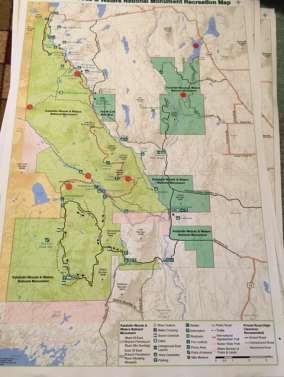
54 Report of Input Prepared by Leigh Tillman Facilitation September 15 th -29 th,


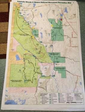
55 Report of Input Prepared by Leigh Tillman Facilitation September 15 th -29 th,

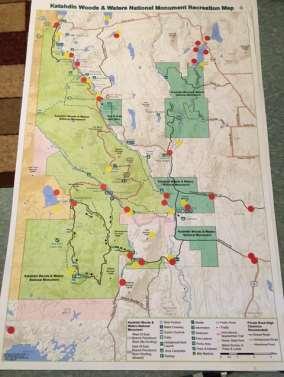


56 East Millinocket/Medway Report of Input Prepared by Leigh Tillman Facilitation September 15 th -29 th,


57 Report of Input Prepared by Leigh Tillman Facilitation September 15 th -29 th,


58 Millinocket Report of Input Prepared by Leigh Tillman Facilitation September 15 th -29 th,


59 Orono/Bangor Report of Input Prepared by Leigh Tillman Facilitation September 15 th -29 th,


60 Report of Input Prepared by Leigh Tillman Facilitation September 15 th -29 th,


61 Report of Input Prepared by Leigh Tillman Facilitation September 15 th -29 th,


62 Report of Input Prepared by Leigh Tillman Facilitation September 15 th -29 th,
Proposal to Redevelop Lower Kananaskis River-Barrier Lake. Bow Valley Provincial Park
 Frequently Asked Questions Proposal to Redevelop Lower Kananaskis River-Barrier Lake Bow Valley Provincial Park Frequently Asked Questions What has been decided? What are the details of the plan? What
Chambers of Commerce and Lake Groups advertised this NCWRPC created online survey that was : Opened: August 22, 2012; and Closed: October 4, 2012.
 Vilas County Outdoor Recreation Survey Chambers of Commerce and Lake Groups advertised this NCWRPC created online survey that was : Opened: August 22, 202; and Closed: October 4, 202. Q What Vilas County
Federal Outdoor Recreation Trends Effects on Economic Opportunities
 United States Department of Agriculture Federal Outdoor Recreation Trends Effects on Economic Opportunities The Forest Service National Center for Natural Resources Economic Research is assisting the Federal
Proposal to Redevelop Lower Kananaskis River-Barrier Lake. Bow Valley Provincial Park. Frequently Asked Questions
 Proposal to Redevelop Lower Kananaskis River-Barrier Lake Bow Valley Provincial Park Frequently Asked Questions What is being proposed? What are the details of the proposal? Where is the project area located?
Preferred Recreation Recommendations Stemilt-Squilchuck Recreation Plan March 2018
 Preferred Recreation Recommendations Stemilt-Squilchuck Recreation Plan March 2018 Below are the recommended recreation ideas and strategies that package together the various recreation concepts compiled
Silver Lake Park An Environmental Jewel for the Citizens of Prince William County
 Silver Lake Park An Environmental Jewel for the Citizens of Prince William County The Prince William Park Authority Mission Statement states: The Prince William County Park Authority will create quality
System Group Meeting #1. March 2014
 System Group Meeting #1 March 2014 Meeting #1 Outcomes 1. Understand Your Role 2. List of Revisions to Existing Conditions 3. Information Sources Study Area The Purpose of Mountain Accord is to Preserve
Crystal Lake Area Trails
 Lake Area Trails Welcome to the Lake area of the Big Snowy Mountains! This island mountain range in central Montana features peaks reaching to 8,600 feet and long, high ridges from which vistas of the
AMERICAN S PARTICIPATION IN OUTDOOR RECREATION: Results From NSRE 2000 (With weighted data) (Round 1)
 (Round 1)") AMERICAN S PARTICIPATION IN OUTDOOR RECREATION: Results From NSRE 2000 (With weighted data) (Round 1) The emphasis of this report is on participation patterns across activities and segments of our society.
AMERICAN S PARTICIPATION IN OUTDOOR RECREATION: Results From NSRE 2000 (With weighted data) (Round 1) The emphasis of this report is on participation patterns across activities and segments of our society.
Rogue River Access and Management Plan Draft Alternatives
 Rogue River Access and Management Plan Draft Alternatives The Rogue River Access and Management Plan was initiated in December, 2011 and is being led by Jackson County Parks (JCP) and Oregon Department
Appendix A BC Provincial Parks System Goals
 Appendix A BC Provincial Parks System Goals The British Columbia Provincial Parks System has two mandates: To conserve significant and representative natural and cultural resources To provide a wide variety
Lake Myra County Park. Wake County, North Carolina Community Forum #2 June 12, 2008
 Lake Myra County Park Wake County, North Carolina Community Forum #2 June 12, 2008 Welcome and Introduction Meeting Agenda Welcome Introductions of Project Team Master Plan Process Community Forum #1 Updates
Clearwater Lake Provincial Park. Draft Management Plan
 Clearwater Lake Provincial Park Draft Management Plan Clearwater Lake Provincial Park Draft Management Plan Table of Contents 1. Introduction... 3 2. Park History... 4 3. Park Attributes... 4 3.1 Location/Access...4
As outlined in the Tatshenshini-Alsek Park Management Agreement, park management will:
 Management Strategy General Strategy The priority management focus for the park is to ensure that its internationally significant natural, cultural heritage and recreational values are protected and that
Maine RV Parks and Campgrounds
 1 Maine RV Parks and Campgrounds Wilderness Edge Campground Brief Description: We are located in the heart of Moose country just minutes from Baxter State Park, Mt. Katahdin, and The Katahdin Woods & Waters
Welcome to the future of Terwillegar Park a Unique Natural Park
 Welcome to the future of Terwillegar Park a Unique Natural Park 1 Introduction The Terwillegar Park Concept Plan study will develop an overall concept plan, management objectives and development guidelines
Map 1.1 Wenatchee Watershed Land Ownership
 Map 1.1 Wenatchee Watershed Land Ownership Map 1.1 Wenatchee Watershed Land Ownership The Wenatchee watershed lies in the heart of Washington state in Chelan County. Just larger than the state of Rhode
STOWER SEVEN LAKES STATE RECREATION TRAIL POLK COUNTY, WISCONSIN. MASTER PLAN June, 2018
 STOWER SEVEN LAKES STATE RECREATION TRAIL POLK COUNTY, WISCONSIN MASTER PLAN June, 2018 Polk County Environmental Services Committee Kim O Connell-Chairman Brad Olson -Vice Chairman Jim Edgell Doug Route
13.1 REGIONAL TOURISM ISSUES AND SUMMARY OF FINDINGS
 13 REGIONAL TOURISM T he County of Mariposa s recreation needs and facilities fall within two categories: regional tourism and local recreation. This Element focuses on regional tourism issues related
Table of Contents. page 3 Long term Goals Project Scope Project History. 4 User Groups Defined Trail Representative Committee. 5 Trail Users Breakdown
 Launched April 27th, 2010 1 Table of Contents page 3 Long term Goals Project Scope Project History 4 User Groups Defined Trail Representative Committee 5 Trail Users Breakdown 13 Trail Users Desires 16
THE INTERNATIONAL APPALACHIAN TRAIL IN MAINE
 THE INTERNATIONAL APPALACHIAN TRAIL IN MAINE INTRODUCTION The Maine section of the IAT/SIA is 130 miles (211kms) long. Heading north from the Katahdin Lake East (KLE) Access trailhead of Baxter State Park,
Making Headway in the Katahdin Region
 MAKING HEADWAY IN YOUR COMMUNITY Making Headway in the Katahdin Region Community Celebration August 20, 2017 Summary Report Making Headway in Your Community is a program of GrowSmart Maine and the Maine
Flow Stand Up Paddle Board Parkway Plan Analysis
 Regional Parks Department Jeffrey R. Leatherman, Director County of Sacramento Divisions Administration Golf Leisure Services Maintenance Rangers Therapeutic Recreation Services Flow Stand Up Paddle Board
Attendance Presentation
 TO The Community of Saanich FROM District of Saanich DATE January 30, 2017 RE Meeting Notes Haro Woods Jan 28th Community Engagement Goward House, 2495 Arbutus Road, Victoria BC Attendance In total, 18
Conrad Historic Site Questionnaire Summary of Responses January 20 May 31, 2016
 Conrad Historic Site Questionnaire Summary of Responses January 20 May 31, 2016 In January, the consultant team, members of the Carcross/Tagish First Nation and the Conrad Steering Committee had an initial
SAXON HARBOR REDEVELOPMENT SURVEY
 SAXON HARBOR REDEVELOPMENT SURVEY SEPTEMBER, 2016 1,173 RESPONSES 1 BACKGROUND 1. WHAT TYPES OF ACTIVITIES DO YOU ENGAGE IN AT SAXON HARBOR Sightseeing Swimming Picnicing Fishing Camping Photography Motorized
The Vision for the San Juan Islands Scenic Byway
 The Vision for the San Juan Islands Scenic Byway 2 Judd Cove, Orcas Island, Courtesy of Kurt Thorson (kurtthorson.com) and San Juan County Land Bank Vision for the San Juan Islands Scenic Byway The San
TAYLOR CANYON RANCH COLORADO - ROUTT COUNTY - STEAMBOAT SPRINGS
 TAYLOR CANYON RANCH COLORADO - ROUTT COUNTY - STEAMBOAT SPRINGS Tucked up against the steep valley shaped by Mt. Pau and rising to the Routt National Forest, Taylor Canyon Ranch is an easily accessible,
Acadia National Park. Visitor Study. The Visitor Services Project
 Acadia National Park Visitor Study The Visitor Services Project 2 OMB Approval 1024-0218 Expiration Date: 03-31-99 United States Department of the Interior NATIONAL PARK SERVICE Acadia National Park P.O.
Payette National Forest Duty Station: New Meadows, Idaho Please respond by March 1, 2013
 THE OPPORTUNITY Payette National Forest Duty Station: New Meadows, Idaho Please respond by March 1, 2013 The Payette National Forest is currently seeking a candidate for a permanent full time Range Program
5.0 OUTDOOR RECREATION OPPORTUNITIES AND MANAGEMENT
 5.0 OUTDOOR RECREATION OPPORTUNITIES AND MANAGEMENT 5.1 Introduction This section describes the range of recreational activities that currently take place in Marble Range and Edge Hills Parks, as well
LOCAL PLAN FOR THE MANAGEMENT OF THE APPALACHIAN TRAIL IN MAINE. (GRAFTON NOTCH TO KATAHDIN) 1 January 2013 (Revised 5 February 2014)
 1 January 2013 (Revised 5 February 2014)") LOCAL PLAN FOR THE MANAGEMENT OF THE APPALACHIAN TRAIL IN MAINE (GRAFTON NOTCH TO KATAHDIN) 1 January 2013 (Revised 5 February 2014) The Appalachian Trail is a way, continuous from Katahdin in Maine to
LOCAL PLAN FOR THE MANAGEMENT OF THE APPALACHIAN TRAIL IN MAINE (GRAFTON NOTCH TO KATAHDIN) 1 January 2013 (Revised 5 February 2014) The Appalachian Trail is a way, continuous from Katahdin in Maine to
CHAPTER 5. Chapter 5 Recreation Element
 CHAPTER 5 Recreation Element Chapter 5 Recreation Element The Recreation Element of the Meyers Area Plan is a supplement to the Recreation Element of the TRPA Regional Plan and the El Dorado County General
Take Me. Outside!!! C.R.X C.R.X. Registration Begins April 30, 2018 ~ Guarantee your spot!
 Caribou Rec. Xtreme Take Me. Outside!!! C.R.X. 2018 C.R.X. Registration Begins April 30, 2018 ~ Guarantee your spot! Allagash, Baxter State Park, Backpacking, Kayaking, Mountain Biking, Camping, Swimming
4.0 OUTDOOR RECREATION 4.1 PUBLIC LANDS
 4.0 OUTDOOR RECREATION 4.1 PUBLIC LANDS Public lands provide a wide range of recreational opportunities and are considered a valuable community asset. There may be seasonal and/or other use restrictions
National Park Service Wilderness Action Plan
 National Park Service U.S. Department of the Interior National Park Service Wilderness Action Plan National Wilderness Steering Committee National Park Service "The mountains can be reached in all seasons.
SOCIAL CONFLICT BETWEEN MOTORIZED AND NON-MOTORIZED RECREATIONAL ACTIVITIES.
 SOCIAL CONFLICT BETWEEN MOTORIZED AND NON-MOTORIZED RECREATIONAL ACTIVITIES. There is a great disparity in opinions about the effects on a person s recreational experience when they encounter others on
O REGON TRAILS SUMMIT. Oregon Trails Summit. Rogue River National Forest
 O REGON TRAILS SUMMIT Oregon Trails Summit 2014 Rogue River National Forest OREGON TRAILS 2015: A VISION FOR THE FUTURE The 2015-2024 Oregon Statewide Trails Plan Why do a trails plan? 2005-2014 Oregon
MARBLE RIVER PROVINCIAL PARK
 MARBLE RIVER PROVINCIAL PARK PURPOSE STATEMENT AND ZONING PLAN March 2003 MARBLE RIVER PROVINCIAL PARK Purpose Statement and Zoning Plan Primary Role The primary role of Marble River Park is to protect
ROYAL GORGE PARK and RECREATION AREA. A Feat of Natural and Man-Made Engineering
 ROYAL GORGE PARK and RECREATION AREA A Feat of Natural and Man-Made Engineering As Growth Resumed in the 1870 s Town Leaders Began to Envision a Tourist Industry. The Arkansas River Canyon was advertised
LIST OF LOCAL SIGHTS AND RECREATION
 LIST OF LOCAL SIGHTS AND RECREATION Pictures of Klamath Falls - http://members.spree.com/sip/sunnidaze/me/kfalls.html One of the local members of Kingsley Field took some pictures of the local area in
COLORADO STATE PARKS NORTHWEST REGION RON VELARDE NORTHWEST REGIONAL MANAGER
 COLORADO STATE PARKS NORTHWEST REGION RON VELARDE NORTHWEST REGIONAL MANAGER COLORADO STATE PARKS NORTHWEST REGION HIGHLINE LAKE JAMES M. ROBB COLORADO RIVER VEGA RIFLE COMPLEX SYLVAN LAKE STAGECOACH STATE
2. Goals and Policies. The following are the adopted Parks and Trails Goals for Stillwater Township:
 D. PARKS AND TRAILS 1. Introduction Stillwater Township s population is relatively low, with most residents living on rural residences on large lots. The need for active park space has been minimal in
East Carolina Council Facility Study East Carolina Scout Reservation Camp Boddie Pamlico Sea Base
 East Carolina Council Facility Study East Carolina Scout Reservation Camp Boddie Pamlico Sea Base 1 VISION OF CAMP BODDIE EAST CAROLINA SCOUT RESERVATION 1. Attract Out Of Council Troops Use our natural
Mammoth Winter Recreation Summit Saturday March 19, 2016
 Mammoth Winter Recreation Summit Saturday March 19, 2016 Track: Winter Recreation at Shady Rest Presenter: Haislip Hayes- Town of Mammoth Lakes (TOML) Presentation Notes 1. 12.5 acres of Shady Rest Park
Nov. 19 th Public Workshop Summary
 On November 19 th, more than 60 community members attended an Open Space Matters workshop at the Linen Building in downtown Boise for over two hours. Participants learned about reserves, discussed the
10/25/2013. What is the SCORP?! 2013 Local Government Survey 2013 Statewide Public Survey Advisory Group Priority Areas Your Suggestions!
 COLORADO OUTDOOR RECREATION TRENDS RESULTS FROM THE SCORP AND STATEWIDE Colorado Outdoor Recreation Resource Partnership September 2013 PRESENTATION What is the SCORP?! 2013 Local Government Survey 2013
MANAGEMENT DIRECTION STATEMENT June, 1999
 Thompson River District MANAGEMENT DIRECTION STATEMENT June, 1999 for Clearwater River Corridor (Addition to Wells Gray Park) Ministry of Environment Lands and Parks BC Parks Division ii Table of Contents
Non-motorized Trail Plan & Proposal. August 8, 2014
 Town of Star Valley Ranch, Wyoming and the Star Valley Ranch Association in partnership with the USDA Forest Service, Bridger-Teton National Forest, Greys River Ranger District Non-motorized Trail Plan
Continental Divide National Scenic Trail Legislative History and Planning Guidance
 Continental Divide National Scenic Trail Legislative History and Planning Guidance Legislation, Policy, and Direction Regarding National Scenic Trails The National Trails System Act, P.L. 90-543, was passed
STONE MOUNTAIN PROVINCIAL PARK Purpose Statement and Zoning Plan
 1 STONE MOUNTAIN PROVINCIAL PARK Purpose Statement and Zoning Plan Stone Mountain Provincial Park is situated 140 km west of Fort Nelson at Kilometre 595 of the Alaska Highway. The 25 690 ha park is located
2009 RIVER TOWN OF THE YEAR AWARD APPLICATION Supplemental Material Images
 2009 RIVER TOWN OF THE YEAR AWARD APPLICATION Supplemental Material Images Our History The earliest record of settlement along the river is in 1854; one of the earliest in Carroll County. About this time
MANAGEMENT DIRECTION STATEMENT June, 1999
 Thompson River District MANAGEMENT DIRECTION STATEMENT June, 1999 for Roche Lake Provincial Park Ministry of Environment Lands and Parks BC Parks Division Table of Contents I. Introduction A. Setting
Welcome and thank you for being here! Kick-Off Public Workshop November 19, 2014
 Welcome and thank you for being here! Kick-Off Public Workshop November 19, 2014 OPEN SPACE MATTERS: Boise s First Reserve Master Plan Julia Grant Foothills and Open Space Manager City of Boise Ellen Campfield
TOURISM & PUBLIC SERVICES RURAL SIGNAGE POLICY
 Policy and Procedures Subject Title: Tourism and Public Services Rural Signage Policy Corporate Policy (Approved by Council): X Policy Ref. No.: ROADS-01-07 Administrative Policy (Approved by CAO): By-Law
Wildlife Tour (10 Days)
") Multi-Sport Camping Adventures Small Groups (10 max) Great Guides Top of the line Equipment Excellent Meals Active Experiences Wildlife Tour (10 Days) For those with wildlife viewing as a primary objective
Multi-Sport Camping Adventures Small Groups (10 max) Great Guides Top of the line Equipment Excellent Meals Active Experiences Wildlife Tour (10 Days) For those with wildlife viewing as a primary objective
Hermosa Area Preservation The Colorado Trail Foundation 4/11/2008
 Hermosa Area Preservation The Colorado Trail Foundation 4/11/2008 Legend d o Tr ail NPA - National Protection Area ra NCA - National Conservation Area o e C Th The Colorado Trail lo FS inventoried Roadless
Business Item No XXX. Proposed Action That the Metropolitan Council approve the Coon Creek Regional Trail Master Plan.
 Business Item No. 2015-XXX Metropolitan Parks and Open Space Commission Meeting date: July 7, 2015 For the Community Development Committee meeting of July 20, 2015 For the Metropolitan Council meeting
Dumont Dunes Special Recreation Management Area (SRMA)
") Dumont Dunes Special Recreation Management Area (SRMA) RMA/RECREATION MANAGEMENT ZONE (RMZ) OBJECTIVE(S) DECISIONS Objective Statement: Designate this area as a Special Recreation Management Area. To manage
Dumont Dunes Special Recreation Management Area (SRMA) RMA/RECREATION MANAGEMENT ZONE (RMZ) OBJECTIVE(S) DECISIONS Objective Statement: Designate this area as a Special Recreation Management Area. To manage
FINAL TESTIMONY 1 COMMITTEE ON RESOURCES UNITED STATES HOUSE OF REPRESENTATIVES. July 13, 2005 CONCERNING. Motorized Recreational Use of Federal Lands
 FINAL TESTIMONY 1 STATEMENT OF DALE BOSWORTH CHIEF Of the FOREST SERVICE UNITED STATES DEPARTMENT OF AGRICULTURE Before the SUBCOMMITTEE ON FORESTS AND FOREST HEALTH And the SUBCOMMITTEE ON NATIONAL PARKS,
Blueways: Rivers, lakes, or streams with public access for recreation that includes fishing, nature observation, and opportunities for boating.
 Parks, Open Space and Trails PRINCE WILLIAM COUNTY 2008 COMPREHENSIVE PLAN TRAILS PLAN CONTENTS The components of the trails plan are: Intent Definitions Goals, Policies, and Action Strategies Trails Map
Public Comment. Comment To consider extending State Park lands above River Mile 7.0
 Public To consider extending Park lands above River Mile 7.0 on the Little Spokane River for the conservation and limited recreation qualities they contain is this request. Could this be included in your
The Frank Church River of No Return Wilderness
 ALLIANCE FOR WILDERNESS EDUCATION AND STEWARDSHIP PO Box 2667, Bellingham, WA 98227-2667 Tele: 360-927-1804 Fax: 360-527-9679 bradt@wildernessalliance.org www.wildernessalliance.org STEWARDS OF AMERICA
A. SHAPING RECREATION DESTINATIONS
 A. SHAPING RECREATION DESTINATIONS Shaping SLV Communities into Recreation Destinations Great trails and recreation opportunities don t just satisfy local athletes, they can also attract tourists, boost
National Recreation Trail Update Form
 National Recreation Trail Update Form Introduction Thank you for taking the time to complete this form. Your assistance will help ensure that the National Recreation Trail (NRT) database is complete and
A CASE FOR COMPLETING THE JORDAN RIVER PARKWAY: A
 A CASE FOR COMPLETING THE JORDAN RIVER PARKWAY: A safe crossing at 9000 South and 850 West Proposed 9000 South Underpass Parkway Timeline Parkway, Trail, and Tourism Facts Blueprint Jordan River 1971 1973
LOUISIANA Department of Culture, Recreation, & Tourism
 Management Plan Louisiana LOUISIANA Department of Culture, Recreation, & Tourism National Park Service U. S. Department of the Interior Management Plan Newsletter 2 Public Comment Summary for Dear Friends,
Outdoor Recreation Opportunities Management
 Outdoor Recreation Opportunities Management Introduction The natural features of Height of the Rockies and Elk Lakes provincial parks provide a wide variety of outdoor recreational activities. However,
Wilds. Headwaters. Lakes. Oxbows. Falls
 56 5 4 3 Wilds Headwaters Lakes Oxbows Falls 57 Zones It could be said the on-the-ground essence of this master plan appears within the next 6 pages of this report. As we learned in the preceding Cultural
Cataloochee. Fishing Species Rainbow Trout and Brook Trout. Recreation
 Cataloochee River Information The Cataloochee River is located in the historic Cataloochee Valley--a relatively remote part of Smoky Mountain National Park. The campground is a secluded setting and offers
Discussion Topics. But what does counting tell us? Current Trends in Natural Resource Management
 Discussion Topics What are the outputs of natural resource management How do we measure what we produce What are the outputs of resource recreation management Ed Krumpe CSS 287 Behavioral approach to management
National Recreation Trail Application for Designation
 National Recreation Trail Application for Designation Introduction Thank you for your interest in the National Recreation Trail (NRT) program. Completed NRT application packages must be submitted by December
Meadow Creek and Goat Creek pass through Goat Falls Ranch & Alpine Peak
 Henri W. LeMoyne 1346 Fillmore Street Post Office Box 5225 Phone: (208) 733-0874 Fax: (208) 733-8475 E-mail: henri@lemoynerealty.com Twin Falls, Idaho 83303-5225 Location: The Goat Falls Ranch is located
Making a River Segment Family and People Friendly: A Case Study of the Pemi River in the Plymouth Region
 Making a River Segment Family and People Friendly: A Case Study of the Pemi River in the Plymouth Region Kenneth Evans, Plymouth Rotary Club Patrick Hummel, DIvision of Parks & Recreation; Larry Spencer,
LESSON 5 Wilderness Management Case Studies
 LESSON 5 Wilderness Management Case Studies Objectives: Students will: review the key points of the Wilderness Act of 1964. brainstorm solutions for Wilderness management issues. Materials: Í Leave no
TWO NIGHT AGENDA. Wednesday Oct Big Ideas, Big Goals Who wants to eat the cake?
 TWO NIGHT AGENDA Wednesday Oct. 27 - Big Ideas, Big Goals Who wants to eat the cake? Survey and background info Case studies Promising projects Thursday Oct. 28 - Making it Real Who wants to help make
WASHINGTON STATE PARKS LAND CLASSIFICATION SYSTEM
 WASHINGTON STATE PARKS LAND CLASSIFICATION SYSTEM Administrative Code Establishing Land Classification System WAC 352-16-020 Land classification system. State park areas are of statewide natural, cultural,
PEMBERTON VALLEY RECREATIONAL TRAILS MASTER PLAN UPDATE Community Open House. April 2018
 PEMBERTON VALLEY RECREATIONAL TRAILS MASTER PLAN UPDATE Community Open House April 2018 Introductions Introductions Matt Bakker, BHA Project Coordinator Other Team Members: Liz Scroggins, Grey Owl Consulting
Sibley LUPA. Board Executive Committee Meeting December 7, 2017
 Sibley LUPA Board Executive Committee Meeting December 7, 2017 Project Location & Project Area 1,318-acre Robert Sibley Volcanic Regional Preserve Project Area Purpose Project Purpose & Goals Append the
Nature-based Tourism Development Workshop Oregon Rural Tourism Studio John Day River Territory December 7, Group Discussion: Outcomes
 Nature-based Tourism Development Workshop Oregon Rural Tourism Studio John Day River Territory December 7, 2010 Group Discussion: Outcomes Top Unique/Uncommon Natural Features in the Region River canyons
Proposed Scotchman Peaks Wilderness Act 2016 (S.3531)
") 1 Proposed Scotchman Peaks Wilderness Act 2016 (S.3531) Frequently Asked Questions PLACE Where is the area that would be designated as Wilderness? The lands outlined in S.3531 lie within Idaho along its
1 Proposed Scotchman Peaks Wilderness Act 2016 (S.3531) Frequently Asked Questions PLACE Where is the area that would be designated as Wilderness? The lands outlined in S.3531 lie within Idaho along its
Methow Trails. Master Plan. Oct
 Methow Trails Master Plan Oct 15 2018 Methow Trails is a 501(c) (3) organization 1.0 INTRODUCTION 2.0 BACKGROUND 2.1 History 2.1.1 Nordic Skiing in the Methow Valley 2.1.2 Connected trail system 2.1.3
THE SENSIBLE ROCKY MOUNTAIN INVESTMENT CHOICE.
 THE SENSIBLE ROCKY MOUNTAIN INVESTMENT CHOICE 1 2 THE SENSIBLE ROCKY MOUNTAIN INVESTMENT CHOICE BIG MOUNTAINS. BIG BUSINESS. BIG OPPORTUNITY. Sparwood, BC is yours and mine. We may be known as that town
MAIN LAKE PROVINCIAL PARK
 MAIN LAKE PROVINCIAL PARK PURPOSE STATEMENT AND ZONING PLAN March 2003 MAIN LAKE PROVINCIAL PARK Purpose Statement and Zoning Plan Primary Role The primary role of Main Lake Park is to protect a biologically
RECREATION ACCESS AND COMMUNITY ENRICHMENT PLAN
 Template for facilitating Siskiyou County, the City of Yreka and the State of Jefferson in a RECREATION ACCESS AND COMMUNITY ENRICHMENT PLAN Access to the Mountains CREATING ACCESS TO PUBLIC AND PRIVATE
Committee Report. Community Development Committee For the Metropolitan Council meeting of August 12, Business Item No.
 Committee Report Business Item No. 2015-168 Community Development Committee For the Metropolitan Council meeting of August 12, 2015 Subject: Coon Creek Regional Trail Master Plan, Anoka County Proposed
Planning and Managing Tourism in Protected Areas
 Planning and Managing Tourism in Protected Areas Mobile Seminar - September 10-25, 2013 CENTER FOR PROTECTED AREA MANAGEMENT AND TRAINING Introduction The Mobile Seminar on Planning and Managing Tourism
Choose Your Adventure!
 Choose Your Adventure! The Schuylkill Center s Summer Adventure Treks challenge pre-teens and teens to improve their outdoor knowledge and skills in a comfortable and supportive setting. Participants learn
ADVENTURE PLAN EXPLORE PARK
 ADVENTURE PLAN ROANOKE COUNTY S EXPLORE PARK ROANOKE COUNTY PARKS, RECREATION AND TOURISM 1206 KESSLER MILL RD SALEM, VA 24153 (540) 387-6078 WHAT S INCLUDED? Explore Park Adventure Plan - Guided by extensive
Vermont Cows by Peter Salmon
 Vermont Cows by Peter Salmon SUSTAINABLE FOREST & PROPERTY MANAGEMENT: At current the Dorset Town Forest includes the 30 acre parcel that sits atop Owl s Head peak in Dorset. By acquiring this property
FORT FLAGLER DEVELOPMENT RESTRICTIONS
 FORT FLAGLER DEVELOPMENT RESTRICTIONS Access via hwy into park is limiting. Folks won t develop so far away from town. This is NOT Ft. Worden. Consider the limited viability of other camping/cabin facilities
Strengthening the Ontario Trails Strategy. Report on Consultations and the Environmental Bill of Rights Registry
 Strengthening the Ontario Trails Strategy Report on Consultations and the Environmental Bill of Rights Registry Purpose To report on the feedback and information received through the regional consultations,
NORTH GEORGIA MOUNTAINS, USA. Pristine Natural Wonder
 NORTH GEORGIA MOUNTAINS, USA Pristine Natural Wonder Pristine Natural Wonder NORTH GEORGIA MOUNTAINS, USA Introduction: This pristine natural wonder is a true geological phenomenon and the Crown Jewel
Business Item No
 Metropolitan Parks and Open Space Commission Meeting date: February 6, 2018 For the Community Development Committee meeting of February 20, 2018 For the Metropolitan Council meeting of February 28, 2018
SUMMER OF WOW! teens GIVE BACK VOLUNTEER ON A TEEN TRAIL CREW WILDERNESS ADVENTURES OVER 40 TRIPS AVAILABLE IN THE WHITE MOUNTAINS, MAINE AND NEW YORK
 OUTDOORS.ORG teens SUMMER OF WOW! GIVE BACK VOLUNTEER ON A TEEN TRAIL CREW EXPLORE AMC 2017 TEEN PROGRAMS WILDERNESS ADVENTURES OVER 40 TRIPS AVAILABLE IN THE WHITE MOUNTAINS, MAINE AND NEW YORK outdoors.org
Androscoggin River Trail Access Sites. North Woods. 168 miles from its source at Lake Umbagog to Merrymeeting Bay
 Androscoggin River Trail Access Sites North Woods 168 miles from its source at Lake Umbagog to Merrymeeting Bay Trail Under Construction More than 40 Public Access Sites Available Androscoggin River Watershed
APPENDIX A: Survey Instruments
 Three different surveys were conducted during the research phase of the NCHA Trails Study. One questionnaire was designed for elected officials and user groups (general public). The other two questionnaires
Wallace Lake Provincial Park. Management Plan
 Wallace Lake Provincial Park Management Plan 2 Wallace Lake Provincial Park Table of Contents 1. Introduction... 3 2. Park History... 3 3. Park Attributes... 4 3.1 Natural... 4 3.2 Recreational... 4 4.
CONTRIBUTOR REWARDS PROGRAM
 CONTRIBUTOR REWARDS PROGRAM Here s how it works... Document + submit an adventure Earn Adventure Points (AP) when it s published Get rewards: awards, prizes, pro deals + earn cash Page Document + submit
DISCUSSION AGENDA OF Pisgah Ledge GEOGRAPHIC AREA SMALL GROUP MEETING SUMMARY REVIEWED
 Wednesday, August 2, 2017 12:00 4:00pm Brevard, NC The Meeting Outcomes: 1. One or more proposals of mutual interests are developed and described for the geographic area (s) of focus and discussion. 2.