STOWER SEVEN LAKES STATE RECREATION TRAIL POLK COUNTY, WISCONSIN. MASTER PLAN June, 2018
|
|
|
- Doris Brown
- 5 years ago
- Views:
Transcription
1 STOWER SEVEN LAKES STATE RECREATION TRAIL POLK COUNTY, WISCONSIN MASTER PLAN June, 2018 Polk County Environmental Services Committee Kim O Connell-Chairman Brad Olson -Vice Chairman Jim Edgell Doug Route Tracy LaBlanc Department of Natural Resources
2 Table of Contents I. INTRODUCTION AND EXECUTIVE SUMMARY II. III. IV. GOALS AND OBJECTIVES A. Goals B. Objectives PROPOSED MANAGEMENT AND LAND DEVELOPMENT A. Land Acquisition and Ownership B. Uses of the Trail Corridor 1. Encouraged Primary Uses 2. Encouraged Secondary Uses 3. Allowed Uses 4. Prohibited Uses C. Development Program 1. Initial Development 2. Long term Development 3. Development Schedule 4. Development Standards D. Operation & Maintenance Program E. Interpretation F. Wildlife Management G. Timber and Vegetative Management H. Management Problems I. Recreation Needs and Justification J. Analysis of Services APPENDIX Map 1-Regional Location Map 2-Polk County A. Memorandum of Agreement-Polk County & State of Wisconsin Department of Natural Resources B. Environmental Site Impact Assessment C. County Board Resolution 2
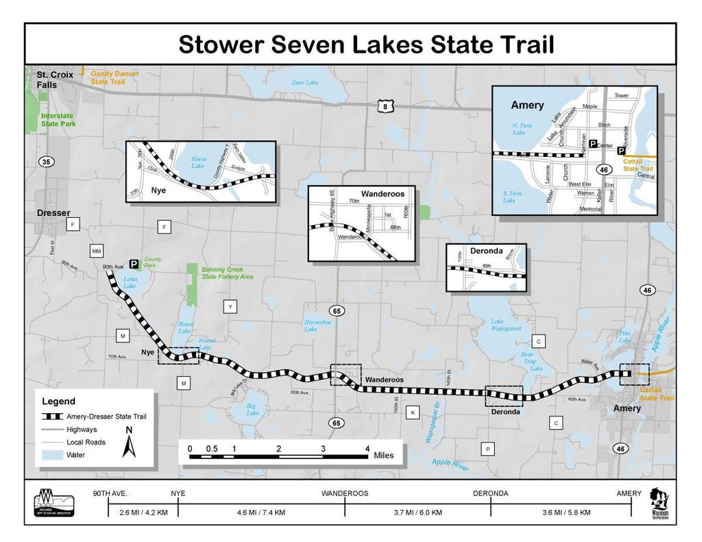
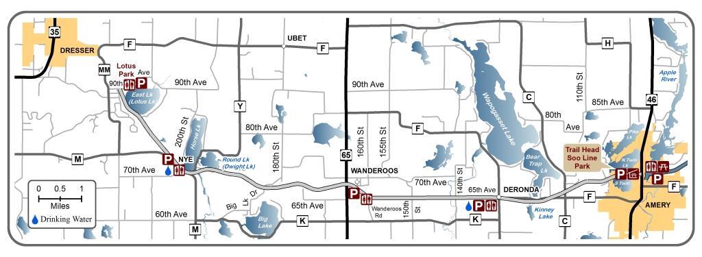
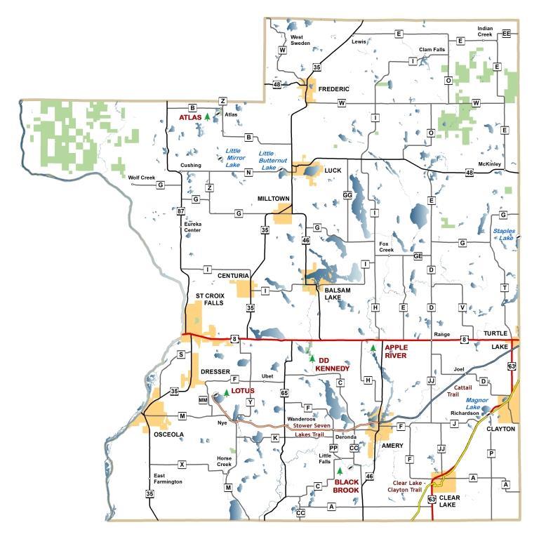
3 Introduction and Executive Summary This draft Stower Seven Lakes Trail Master Plan is a modification of the 2004 Master Plan in order to reflect current uses allowed and prohibited on the trail. Aspects of this draft are currently incomplete and will be developed by the Subcommittee, as part of the trail planning process chosen by the Environmental Services Committee of the Polk County Board of Supervisors. Throughout the process, updates to this plan will be made as decisions are approved by the Subcommittee. See the Public Participation section of this plan for more details on the process. This Master Plan represents the strategy of Polk County as well as various trail advocates and user groups, and the Wisconsin Department of Natural Resources (WDNR) for the development, operation, and maintenance of a mile railroad corridor presently known as the Stower Seven Lakes Trail. The trail is located on a former Minneapolis St. Paul and Sault Ste. Marie Railroad right-ofway which begins two miles east of Dresser and extends into the City of Amery, Wisconsin. Within the City of Amery, the corridor width ranges from 60 feet wide to 180 feet wide, whereas in the rural branch of the corridor, the trail width rightof-way is consistently 100 feet wide. The trail consists of approximately 174 acres and generally runs in a west to east direction. Map 1 shows the regional location of the trail. Map 2 shows the location of the trail in Polk County. The trail right-of-way was acquired from Wisconsin Central Limited in 2003 by the WDNR under the Stewardship Program. Subsequently, a Memorandum of Understanding (MOU) was signed by the Wisconsin Department of Natural Resources (WDNR) and the County of Polk (Appendix A). Under the terms of the MOU, the WDNR will grant a trail easement to Polk County as well as designate the trail as a State Trail under section NR 51.73, Wis. Adm. Code. The WDNR will also complete an environmental review of the property pursuant to s. 1.11, Stats., and Chapter NR 150, Wis. Adm. Code. In addition, the WDNR will work with Polk County to identify funding sources for the development and repair of the trail. Under this same MOU, Polk County will be responsible for the development, operation, repair, and maintenance of the trail. The trail will be developed in phases depending on trail usage and funding availability. II. Goals and Objectives* 3
4 A. Goals: Provide and preserve a recreational trail at least 13 miles in length stretching from Dresser to Amery. The all-season trail will have a dual surface to provide two-way traffic for bicycling, hiking, horseback riding and winter snowmobile use. B. Objectives: To complement present economic benefits of trails existing in Polk County and provide opportunities for economic development not reflected in current trail usage. To provide recreational opportunities that complement present trail opportunities in Polk County and provide recreational opportunities that presently are underrepresented in the Polk County Trail system. To enhance opportunities for tourism in Polk County. To respect the wishes and investments of landowners and communities through which the trail passes. To provide for recreational opportunities that promotes the health and safety of the community. To preserve the rural character and environmental integrity of the trail. To anticipate the urbanization of the area through which the trail passes and provide for possible future use of the trail as an alternative transportation system between communities. To provide opportunities for the greatest number of projected uses of the trail consistent with the previous objectives. On July 31, 2018 a public hearing was held in Polk County to assess the interested public s desired uses or the trail. The information gained from these public hearings, in combination with information and input from other sources, formed the basis for the proposed recreational trail use. 4
5 III. Proposed Management and Land Development A. Land Acquisition and Ownership The Wisconsin Department of Natural Resources (WDNR) acquired the rail grade right-of-way from the Wisconsin Central Limited by means of Stewardship funds. The WDNR has paid all costs to acquire the property and will maintain ownership of the entire rightof-way. Under the terms of the MOA, the WDNR will convey a nonexclusive easement to Polk County and other valuable consideration. The WDNR will not issue other easements that will adversely affect the use of the property for the intended trail purposes. Additional property may be acquired to support trail functions and unique ecosystems. B. Uses of the Trail Corridor 1. Encouraged Primary Uses o Bicycling o Walking, Hiking, Jogging o Dog sledding o Nature and scenery viewing o Snowmobiling: Snow covered periods. When permitted by the Polk County Parks department. Only groomed areas maybe traveled o ATV/UTV with stringent speed limit restrictions of 15 mph near village boundaries, housing, parks, trail heads shelters, public gathering places and business establishments to account for noise and safety on primary rail bed portion of the trail corridor. 2. Encouraged Secondary Uses o Cross country skiing o Snowshoeing o Horseback riding 3. Allowed Uses o Only Administrative and maintenance vehicles o Pets: With restrictions including leashes, feces disposal and closed areas. o Small electric carts used by disabled individuals during snow-free periods o Vehicles on designated roadways and parking areas may operate within the trail corridor. 5
6 o Public Road Crossings: WDNR rules will govern this, and as landowner, WDNR will be the primary contact. o Private Residential Crossings: WDNR rules will govern this, and as landowner, WDNR will be the primary contact. o Private Farm and Recreation Crossings: WDNR rules will govern this, and as landowner, WDNR will be the primary contact. o Other crossings: WDNR rules will govern this, and as landowner, WDNR will be the primary contact. o Utilities: WDNR rules will govern this, and as landowner, WDNR will be the primary contact. 4. Prohibited Uses o Motorized Vehicles including but not limited to: o ATV s/utv s every season o Off-highway motorcycles. o Hunting and trapping. o Camping: Within the trail corridor except in designated campsites. o Private occupancy. o Conducting Business, Promotions or Advertising: Within the trail corridor without the express consent of the Polk County Environmental Services Committee and the WDNR. C. Development Program 1. Initial Development The MOU specifies that the development of the trail is the responsibility of Polk County. The WDNR will grant an easement to Polk County for the development, maintenance and operation of the trail. It is understood that the WDNR will assist Polk County financially with trail development through available grant/aid programs. Under the terms of the MOU, the trail will be managed by Polk County Buildings, Solid Waste and Parks Department. The planned development was phased to allow for orderly and financially affordable development. 2. Development Standards In accordance with the MOU, the trail was developed in compliance with the WDNR Design Standards Handbook, WDNR Snowmobile Trail Signing Handbook (Publ-AA-023), and AASHTO Guide for the Development of Bicycle Facilities will also be followed. All structures placed in the WDNR Right-Of-Way will need prior WDNR approval. 6
7 Associated facilities, if any, will be designed and constructed in compliance with state and local building codes and the American s With Disabilities Act. Provide for the development, with appropriate stake-holders, of a plan to create a parallel silent-sport-only trail within the corridor separate from the original rail bed trail. D. Operation & Maintenance Program Polk County will have the primary responsibility for the operation and maintenance of the trail in Polk County. The Buildings, Solid Waste and Park Department under the direction of the Environmental Services Committee will act as the primary agent of the County. The Friends of the Stower Seven Lakes Trail group has been established and will assist in planning and accomplishing the operation and maintenance of the trail along with the Polk County Snowmobile Council for winter snowmobile use. The daily operation of the trail will be directed by Chapters NR 45 (State Parks and State Forests) and NR 50 (Administration of Outdoor Recreation Program Grants and State Aids). These codes will be supplemented by Polk County ordinances and park directives. Daily operation is directed and performed by the Polk County Buildings, Solid Waste and Park Department and its contractors and cooperators. Daily routine enforcement is the responsibility of Polk County. User fees will not exceed those established in s , Stats., and will be subject to written approval by the WDNR. The standard state trail bicycle fees will be charged and State bicycle trail passes will be honored. User information will include maps, brochures and signing that will provide facility, service, safety and emergency information, rules, regulations and advice on a seasonal basis. Trail maintenance is directed and performed by the Polk County Buildings, Solid Waste and Park Department and its contractors and cooperators. Primary cooperators are the Friends of the Stower Seven Lakes Trail Group who oversee trail maintenance. E. Interpretation In Polk County the trail offers many opportunities to make trail users more aware of the landscape they are traveling through. Opportunities exist to provide interpretive information on the geology, the numerous ecosystems, the native wildlife, and the cultural history of the area. Interpretation is a long-term objective that can be accomplished jointly by Polk County and local interest groups. 7
8 F. Wildlife Management The trail passes through many ecosystems and will provide many opportunities to observe wildlife. Due to the limited land base, many wildlife management opportunities are precluded. Polk County will cooperate with the WDNR and other groups interested in wildlife management in making the trail corridor available to wildlife management within the overall objectives of the master plan. G. Timber and Vegetative Management The vegetation adjacent to the trail is representative of the great natural diversity that occurs in Northwestern Wisconsin. Most species are native or are considered to be naturalized thus requiring little vegetative management. Some management will be practiced to promote aesthetics, eradicate invasive species, enhance wildlife, protect prairie and oak savannas, and protect trail users and facilities. H. Management Problems A number of management problems have been identified that will need to be dealt with as they occur. More may be updated through the trail planning process. Control of non-allowed uses will be achieved through a combination of public information, using Park and Sheriff s Department personnel, and peer pressure as use of the trail increases. Vandalism to signs, bridges and the trail surface will be addressed through regular inspections, rapid repair, enforcement, and peer pressure as the use of the trail increases. Trail crossings will require much attention. All existing crossing agreements will require review and modification to reflect the present and future uses. Requests for new crossings will be handled on an individual basis in accord with the WDNR Department Design Standards Handbook. Routine inspection will insure compliance to crossing agreements and will ensure control of unauthorized crossings. Trespass, both to and from the trail corridor may require the use of various control options including planting, fencing, signing, surveying and law enforcement. Invasive species management I. Recreation Needs and Justification Following is Wisconsin s Statewide Compliance Outdoor Recreation Plan (SCORP) identifying participants by participation rate (Age 8
9 16+), 5 year view of various outdoor recreation activities. The following counties are part of the Great Northwest Region: Ashland, Barron, Bayfield, Burnett, Douglas, Polk, Rusk, Sawyer, and Washburn. From the input received during this process, the following chart shows the identified recreation needs: Participation Number of Percent Participants Activity Participating (1,000s) Walk for pleasure ,947 View/photograph natural scenery ,939 Attend outdoor sports events ,926 Family gathering ,858 Visit nature centers, etc ,858 View/photograph other wildlife ,606 Driving for pleasure ,377 View/photograph wildflowers, trees, etc ,359 Sightseeing ,278 Bicycling ,192 Picnicking ,115 Visit historic sites ,102 Snow/ice activities (any type) ,066 Gather mushrooms, berries, etc , Participation Number of Percent Participants Activity Participating (1,000s) Off-highway vehicle driving Trail running Snowmobiling Cross country skiing Horseback riding on trails Snowshoeing Inline skating Day hiking ,652 Running or jogging ,445 Mountain biking ,382 Sledding ,269 J. Analysis of Services The potential need and demand for trail support services and facilities such as equipment rental and service, bicycle pass outlets, food, beverages, lodging, accessories, memorabilia, etc. will occur to some degree in the future. As it is quite difficult to accurately predict either the future use of the trail or the corresponding ability of the public sector to respond to it, the recommended alternative is (b) public/private cooperation. The public sector will encourage the private sector to provide for trail user needs. When necessary, the public sector will cooperate in the provisions of support facilities and services. The issue of public participation in the provision of the trail support facilities and services should be closely reviewed at least every five years and the trail Master Plan revised accordingly. 9
10 APPENDIX 10
11 Map 1 11
12 Map 2 12
13 13
14 APPENDIX A: MOU 14
15 15
16 16
17 17
18 18
19 19
20 20
21 21

22 APPENDIX B: IMPACT ASSESSMENT 22
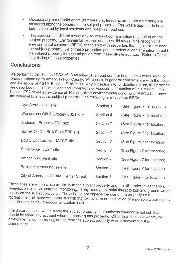
23 23
24 24
25 25

26 26
27 APPENDIX C: RESOLUTION 27
28 28
29 29
Rule Governing the Designation and Establishment of All-Terrain Vehicle Use Trails on State Land
 Rule Governing the Designation and Establishment of All-Terrain Vehicle Use Trails on State Land 1.0 Authority 1.1 This rule is promulgated pursuant to 23 V.S.A. 3506. Section 3506 (b)(4) states that an
Chapter 6: POLICY AND PROCEDURE RECOMMENDATIONS
 Chapter 6 POLICY AND PROCEDURE RECOMMENDATIONS FOR SRRA Below are seven policy elements that should be considered for adoption by the Southwest Regional Recreation Authority of Virginia: 1. Develop strategies
Ordinance Number Snowmobiles and ATVs. Replaces pages See also Section County ATV Ordinance.
 Ordinance Number 05-2009 Snowmobiles and ATVs Replaces pages 900-28 - 900-29 See also Section 905.2.2 County ATV Ordinance Amended 02-15-11 ORDINANCE NO. 05-2009 WHEREAS, the use of snowmobiles and All
Business Item No
 Metropolitan Parks and Open Space Commission Meeting date: February 6, 2018 For the Community Development Committee meeting of February 20, 2018 For the Metropolitan Council meeting of February 28, 2018
Continental Divide National Scenic Trail Legislative History and Planning Guidance
 Continental Divide National Scenic Trail Legislative History and Planning Guidance Legislation, Policy, and Direction Regarding National Scenic Trails The National Trails System Act, P.L. 90-543, was passed
METROPOLITAN COUNCIL 390 North Robert Street, St. Paul, MN Phone (651) TDD (651)
 TDD (651)") METROPOLITAN COUNCIL 390 North Robert Street, St. Paul, MN 55101 Phone (651) 602 1000 TDD (651) 291 0904 DATE: June 19, 2007 TO: Metropolitan Parks and Open Space Commission FROM: Jan Youngquist, Senior
METROPOLITAN COUNCIL 390 North Robert Street, St. Paul, MN 55101 Phone (651) 602 1000 TDD (651) 291 0904 DATE: June 19, 2007 TO: Metropolitan Parks and Open Space Commission FROM: Jan Youngquist, Senior
BAYFIELD COUNTY FOREST COMPREHENSIVE LAND USE PLAN TABLE OF CONTENTS CHAPTER 700 ACCESS MANAGEMENT ROADS AND TRAILS
 BAYFIELD COUNTY FOREST COMPREHENSIVE LAND USE PLAN TABLE OF CONTENTS CHAPTER 700 ACCESS MANAGEMENT ROADS AND TRAILS 700 Access Management/Roads and Trails 3 700.1 History 3 700.2 Current Status 3 700.3
13.1 REGIONAL TOURISM ISSUES AND SUMMARY OF FINDINGS
 13 REGIONAL TOURISM T he County of Mariposa s recreation needs and facilities fall within two categories: regional tourism and local recreation. This Element focuses on regional tourism issues related
Susitna-Watana Hydroelectric Project (FERC No ) Recreation Resources Study Study Plan Section Study Implementation Report
 Recreation Resources Study Study Plan Section Study Implementation Report") (FERC No. 14241) Recreation Resources Study Study Plan Section 12.5 2014 Study Implementation Report Prepared for Prepared by AECOM November 2015 TABLE OF CONTENTS 1. Introduction... 4 2. Study Objectives...
(FERC No. 14241) Recreation Resources Study Study Plan Section 12.5 2014 Study Implementation Report Prepared for Prepared by AECOM November 2015 TABLE OF CONTENTS 1. Introduction... 4 2. Study Objectives...
Blueways: Rivers, lakes, or streams with public access for recreation that includes fishing, nature observation, and opportunities for boating.
 Parks, Open Space and Trails PRINCE WILLIAM COUNTY 2008 COMPREHENSIVE PLAN TRAILS PLAN CONTENTS The components of the trails plan are: Intent Definitions Goals, Policies, and Action Strategies Trails Map
City of Durango 5.8 FUNDING TRAILS DEVELOPMENT
 5.8 FUNDING TRAILS DEVELOPMENT The City has been successful in establishing dedicated local funding sources as well as applying for grants to develop the City s trail system, having received nearly $2.4
CHAPTER III: TRAIL DESIGN STANDARDS, SPECIFICATIONS & PERMITS
 CHAPTER III Trail Design Standards, Specifications & Permits This chapter discusses trail standards, preferred surface types for different activities, permits, and other requirements one must consider
NATIONAL PARK SERVICE CERTIFICATION OF COMPLETED SEGMENTS OF THE NORTH COUNTRY NATIONAL SCENIC TRAIL
 NATIONAL PARK SERVICE CERTIFICATION OF COMPLETED SEGMENTS OF THE NORTH COUNTRY NATIONAL SCENIC TRAIL Completed trail segments that (1) follow the route identified in the 1982 National Park Service (NPS)
CHAPTER FOUR: TRANSPORTATION
 CHAPTER FOUR: TRANSPORTATION Barron County Comprehensive Plan: Transportation Page 61 Background Transportation facilities have a significant influence on land use, development and quality of life for
Chambers of Commerce and Lake Groups advertised this NCWRPC created online survey that was : Opened: August 22, 2012; and Closed: October 4, 2012.
 Vilas County Outdoor Recreation Survey Chambers of Commerce and Lake Groups advertised this NCWRPC created online survey that was : Opened: August 22, 202; and Closed: October 4, 202. Q What Vilas County
PROUDLY BRINGING YOU CANADA AT ITS BEST. Management Planning Program NEWSLETTER #1 OCTOBER, 2000
 PROUDLY BRINGING YOU CANADA AT ITS BEST VUNTUT NATIONAL PARK Management Planning Program NEWSLETTER #1 OCTOBER, 2000 INTRODUCTION This newsletter launches the development of the first management plan for
RATTLESNAKE HILL PHILLIPS, HARRIS FARM, LIME KILN & QUARRY
 Town of, MA Trails Map 6a SPLIT ROCK PRIMARY SECONDARY PRIVATE PRIVATE PROPERY STAY ON HEAD FUTURE TO SKINNER (NOT MARKED) 0 miles 0.25 0.250 0.5 Mapbox, Data Odbl, OpenStreetMap contributors primary use
Flow Stand Up Paddle Board Parkway Plan Analysis
 Regional Parks Department Jeffrey R. Leatherman, Director County of Sacramento Divisions Administration Golf Leisure Services Maintenance Rangers Therapeutic Recreation Services Flow Stand Up Paddle Board
4.0 OUTDOOR RECREATION 4.1 PUBLIC LANDS
 4.0 OUTDOOR RECREATION 4.1 PUBLIC LANDS Public lands provide a wide range of recreational opportunities and are considered a valuable community asset. There may be seasonal and/or other use restrictions
Lincoln County ORP Survey Response Summary
 Lincoln County ORP Survey Response Summary North Central Wisconsin Regional Planning Commission Q1 Which recreational activities did you participate in during 2015? (Choose all that apply.) Answered: 125
F. Forest Recreation Management
 F. Forest Recreation Management F.1) Park and Recreation Management F.1.A. Program Overview. The park and recreation program has been in existence since 1980. With ever increasing outdoor recreation demands
Rogue River Access and Management Plan Draft Alternatives
 Rogue River Access and Management Plan Draft Alternatives The Rogue River Access and Management Plan was initiated in December, 2011 and is being led by Jackson County Parks (JCP) and Oregon Department
Kelly Motorized Trails Project Proposed Action
 Kelly Motorized Trails Project Proposed Action November 28, 2011 The Flagstaff Ranger District of the Coconino National Forest is seeking public input on the proposed Kelly Motorized Trails Project (formerly
Appendix D ( Rock Climbing Survey) Scroll Down
 Scroll Down") Appendix D (E-mail Rock Climbing Survey) Scroll Down 51 2006 Coopers Rock Recreation Study West Virginia University Dear Recreationist: The Department of Recreation, Parks, and Tourism Resources at West
Appendix D (E-mail Rock Climbing Survey) Scroll Down 51 2006 Coopers Rock Recreation Study West Virginia University Dear Recreationist: The Department of Recreation, Parks, and Tourism Resources at West
Business Item No XXX. Proposed Action That the Metropolitan Council approve the Coon Creek Regional Trail Master Plan.
 Business Item No. 2015-XXX Metropolitan Parks and Open Space Commission Meeting date: July 7, 2015 For the Community Development Committee meeting of July 20, 2015 For the Metropolitan Council meeting
ORDINANCE NO. JACKSON TOWNSHIP, CAMBRIA COUNTY
 ORDINANCE NO. JACKSON TOWNSHIP, CAMBRIA COUNTY AN ORDINANCE OF THE TOWNSHIP OF JACKSON AMENDING SECTIONS OF THE JACKSON TOWNSHIP ZONING ORDINANCE AS FOLLOWS: PROVIDING NEW DEFINITIONS OF CAMPGROUNDS, CAMPSITE,
2. Goals and Policies. The following are the adopted Parks and Trails Goals for Stillwater Township:
 D. PARKS AND TRAILS 1. Introduction Stillwater Township s population is relatively low, with most residents living on rural residences on large lots. The need for active park space has been minimal in
Section 3.6 Recreation
 3.6 RECREATION This section evaluates the potential impacts of the proposed project on recreation within MTRP. The evaluation is based on field observations, a review of maps of MTRP and the MTRP Master
CHAPTER 5. Chapter 5 Recreation Element
 CHAPTER 5 Recreation Element Chapter 5 Recreation Element The Recreation Element of the Meyers Area Plan is a supplement to the Recreation Element of the TRPA Regional Plan and the El Dorado County General
APPENDIX A1. NATIONAL TRAILS SYSTEM
 APPENDIX A1. NATIONAL TRAILS SYSTEM Acts of October 2, 1968 (PL 90-543), Nov. 10, 1978, March 28, 1983 (PL 98-11), Dec. 11, 1987 (PL 100-187), Oct. 4, 1988 (PL 100-470), 2006 (PL 109-418). 16 USC 1241-1251.
Pembina Valley Provincial Park. Draft Management Plan
 Pembina Valley Provincial Park Draft Management Plan 2 Pembina Valley Provincial Park Table of Contents 1. Introduction... 3 2. Park History... 3 3. Park Attributes... 3 3.1 Natural... 3 3.2 Recreational...
Recreation Opportunity Spectrum for River Management v
 Recreation Opportunity Spectrum for Management v. 120803 Introduction The following Recreation Opportunity Spectrum (ROS) characterizations and matrices mirror the presentation in the ROS Primer and Field
System Group Meeting #1. March 2014
 System Group Meeting #1 March 2014 Meeting #1 Outcomes 1. Understand Your Role 2. List of Revisions to Existing Conditions 3. Information Sources Study Area The Purpose of Mountain Accord is to Preserve
5.0 OUTDOOR RECREATION OPPORTUNITIES AND MANAGEMENT
 5.0 OUTDOOR RECREATION OPPORTUNITIES AND MANAGEMENT 5.1 Introduction This section describes the range of recreational activities that currently take place in Marble Range and Edge Hills Parks, as well
Cascade River State Park Management Plan Amendment
 This document is made available electronically by the Minnesota Legislative Reference Library as part of an ongoing digital archiving project. http://www.leg.state.mn.us/lrl/lrl.asp Cascade River State
Longmont to Boulder Regional Trail Jay Road Connection DRAFT FINAL REPORT
 Longmont to Boulder Regional Trail Jay Road Connection DRAFT FINAL REPORT December 2018 Project Summary Boulder County, Colorado, in partnership with the City of Boulder, is evaluating options for multi-use
3.0 LEARNING FROM CHATHAM-KENT S CITIZENS
 3.0 LEARNING FROM CHATHAM-KENT S CITIZENS An important aspect in developing the Chatham-Kent Trails Master Plan was to obtain input from stakeholders and the general public. Throughout the course of the
Committee Report. Community Development Committee For the Metropolitan Council meeting of August 12, Business Item No.
 Committee Report Business Item No. 2015-168 Community Development Committee For the Metropolitan Council meeting of August 12, 2015 Subject: Coon Creek Regional Trail Master Plan, Anoka County Proposed
LONG TERM (OPERATION) IMPACTS AND POTENTIAL MITIGATION
 IMPACTS AND POTENTIAL MITIGATION") 3.6 This chapter provides a project-level analysis of potential impacts to recreation sites in the study area including parks, natural areas, open spaces, trails, and playfields, as well as amenities such
3.6 This chapter provides a project-level analysis of potential impacts to recreation sites in the study area including parks, natural areas, open spaces, trails, and playfields, as well as amenities such
AGENDA ITEM 5 D WAKULLA ENVIRONMENTAL INSTITUTE (WEI) TRAIL FEASIBILITY STUDY
 TRAIL FEASIBILITY STUDY") March 19, 2018 AGENDA ITEM 5 D WAKULLA ENVIRONMENTAL INSTITUTE (WEI) TRAIL FEASIBILITY STUDY TYPE OF ITEM: Action STATEMENT OF ISSUE The Wakulla Environmental Institute (WEI) Trail is one of several trails
March 19, 2018 AGENDA ITEM 5 D WAKULLA ENVIRONMENTAL INSTITUTE (WEI) TRAIL FEASIBILITY STUDY TYPE OF ITEM: Action STATEMENT OF ISSUE The Wakulla Environmental Institute (WEI) Trail is one of several trails
Conservation Area Management Statement
 Conservation Area Management Statement Miller Creek Wildlife Area Resolution #: Approval: Issue Date: Date of Last Revision: Table of Contents 1. Purpose....... 1 2. Property Description...... 1 2.1. Legal
FINAL TESTIMONY 1 COMMITTEE ON RESOURCES UNITED STATES HOUSE OF REPRESENTATIVES. July 13, 2005 CONCERNING. Motorized Recreational Use of Federal Lands
 FINAL TESTIMONY 1 STATEMENT OF DALE BOSWORTH CHIEF Of the FOREST SERVICE UNITED STATES DEPARTMENT OF AGRICULTURE Before the SUBCOMMITTEE ON FORESTS AND FOREST HEALTH And the SUBCOMMITTEE ON NATIONAL PARKS,
METROPOLITAN COUNCIL 390 North Robert Street, St. Paul, MN Phone (651) TDD (651)
 TDD (651)") DATE: March 27, 2012 METROPOLITAN COUNCIL 390 North Robert Street, St. Paul, MN 55101 Phone (651) 602-1000 TDD (651) 291-0904 TO: Metropolitan Parks and Open Space Commission FROM: Arne Stefferud, Planning
DATE: March 27, 2012 METROPOLITAN COUNCIL 390 North Robert Street, St. Paul, MN 55101 Phone (651) 602-1000 TDD (651) 291-0904 TO: Metropolitan Parks and Open Space Commission FROM: Arne Stefferud, Planning
O REGON TRAILS SUMMIT. Oregon Trails Summit. Rogue River National Forest
 O REGON TRAILS SUMMIT Oregon Trails Summit 2014 Rogue River National Forest OREGON TRAILS 2015: A VISION FOR THE FUTURE The 2015-2024 Oregon Statewide Trails Plan Why do a trails plan? 2005-2014 Oregon
MOREAU LAKE STATE PARK CURRENT PLANNING EFFORTS
 MOREAU LAKE STATE PARK CURRENT PLANNING EFFORTS PLANNING EFFORTS S O U T H E R N PA L M E R T O W N CONSERVATION & ECONOMIC DEVELOPMENT STRATEGY Moreau Lake State Park Master Plan Mt. McGregor Correctional
Park Design and Location Criteria
 Park Design and Location Criteria This section is presented in the interest of assisting park and recreation agencies in the development of a system of parks and recreation areas. A recreation system is
Watchorn Provincial Park. Management Plan
 Watchorn Provincial Park Management Plan 2 Watchorn Provincial Park Table of Contents 1. Introduction... 3 2. Park History... 3 3. Park Attributes... 3 3.1 Natural... 4 3.2 Recreational... 4 3.3 Additional
FEASIBILITY CRITERIA
 This chapter describes the methodology and criteria used to evaluate the feasibility of developing trails throughout the study areas. Land availability, habitat sensitivity, roadway crossings and on-street
S Central Coast Heritage Protection Act APRIL 21, 2016
 STATEMENT OF GLENN CASAMASSA ASSOCIATE DEPUTY CHIEF, NATIONAL FOREST SYSTEM U.S. FOREST SERVICE U.S. DEPARTMENT OF AGRICULTURE BEFORE THE UNITED STATES SENATE COMMITTEE ON ENERGY AND NATURAL RESOURCES
Chapter 9 Recreation
 Chapter 9 Chapter 9 1.0 INTRODUCTION The Town of Littleton is within one of New England s most important recreation areas. More than three million people live within 100 miles of the area. Local residents
112th CONGRESS. 1st Session H. R. 113 IN THE HOUSE OF REPRESENTATIVES
 HR 113 IH 112th CONGRESS 1st Session H. R. 113 To provide for additions to the Cucamonga and Sheep Mountain Wilderness Areas in the Angeles and San Bernardino National Forests and the protection of existing
LANGLADE COUNTY ICE AGE NATIONAL SCENIC TRAIL CONDITIONS
 LANGLADE COUNTY ICE AGE NATIONAL SCENIC TRAIL CONDITIONS (As of September 1, 2014) Due to situations beyond the control of the Langlade County Chapter of the Ice Age Trail Alliance, conditions are constantly
ONTARIO TRAILS COUNCIL FAQ
 Trail Facts Ontario has some of the most treasured and protected outdoor areas in the world with: 329 Provincial Parks 400 Conservation Areas 292 Conservation Reserves Many people link trails with recreation
Trail Management Objectives (TMO s)
") Trail Management Objectives (TMO s) TMO s are the foundation for solid, consistent trail planning, survey & design, construction, maintenance, periodic condition assessment & prescriptions, and on-going
Trail Management Objectives (TMO s) TMO s are the foundation for solid, consistent trail planning, survey & design, construction, maintenance, periodic condition assessment & prescriptions, and on-going
CHAPTER ONE LITERATURE REVIEW
 CHAPTER ONE LITERATURE REVIEW LITERATURE REVIEW This chapter summarizes the most recently published community impact studies and articles that relate to multiuse trails. The review focuses on publications
Payette National Forest Duty Station: New Meadows, Idaho Please respond by March 1, 2013
 THE OPPORTUNITY Payette National Forest Duty Station: New Meadows, Idaho Please respond by March 1, 2013 The Payette National Forest is currently seeking a candidate for a permanent full time Range Program
Logo Department Name Agency Organization Organization Address Information 5700 North Sabino Canyon Road
 Logo Department Name Agency Organization Organization Address Information United States Forest Coronado National Forest 5700 North Sabino Canyon Road Department of Service Santa Catalina Ranger District
Marchand Provincial Park. Management Plan
 Marchand Provincial Park Management Plan 2 Marchand Provincial Park Table of Contents 1. Introduction... 3 2. Park History... 3 3. Park Attributes... 4 3.1 Natural... 4 3.2 Recreational... 4 3.3 Additional
2016 Regional Transportation Alternatives Program (TAP) Grant Application
 Grant Application") 2016 Regional Transportation Alternatives Program (TAP) Grant Application PROJECT TITLE: Yelm-Tenino Trail Extension Feasibility Study TRPC use only GENERAL PROJECT INFORMATION Agency or Organization City
2016 Regional Transportation Alternatives Program (TAP) Grant Application PROJECT TITLE: Yelm-Tenino Trail Extension Feasibility Study TRPC use only GENERAL PROJECT INFORMATION Agency or Organization City
Pillar Park. Management Plan
 Pillar Park Management Plan January 2014 Pillar Park Management Plan Approved by: Jeff Leahy Regional Director Thompson Cariboo Region BC Parks January 9, 2014 Date Brian Bawtinheimer Executive Director
EXECUTIVE SUMMARY PROGRAM DEVELOPMENT REPORT PURPOSE EXISTING SETTING EXPANDING PARKLAND
 EXECUTIVE SUMMARY PROGRAM DEVELOPMENT REPORT PURPOSE As the culmination of the first phase of the master planning process, this Program Development Report creates the framework to develop the Calero County
D1 January 8, 2014 Public Hearing APPLICANT: HUNT CLUB FARM
 D1 January 8, 2014 Public Hearing APPLICANT: HUNT CLUB FARM PROPERTY OWNER: HUNT CLUB A-1- A, LLC. STAFF PLANNER: Kevin Kemp REQUEST: Modification of a Conditional Use Permit approved by the City Council
Preferred Recreation Recommendations Stemilt-Squilchuck Recreation Plan March 2018
 Preferred Recreation Recommendations Stemilt-Squilchuck Recreation Plan March 2018 Below are the recommended recreation ideas and strategies that package together the various recreation concepts compiled
National Recreation Trail Application for Designation
 National Recreation Trail Application for Designation Introduction Thank you for your interest in the National Recreation Trail (NRT) program. Completed NRT application packages must be submitted by December
Appendix 4.8 A. Agency Correspondence and Final APE Statement
 Appendix 4.8 A Agency Correspondence and Final APE Statement Area of Potential Effect for Cultural Resources Introduction The South Coast Rail project requires review by the Army Corps of Engineers (Corps),
PLANNING COMMISSION AGENDA REPORT May 10, Members of the Planning Commission. Joyce Parker-Bozylinski, Contract Planner
 PLANNING COMMISSION AGENDA REPORT May 10, 2007 TO: FROM: PROPOSAL: APPLICANT: RECOMMENDATION: Members of the Planning Commission Joyce Parker-Bozylinski, Contract Planner Approval of the Calabasas Trails
Section II. Planning & Public Process Planning for the Baker/Carver Regional Trail began in 2010 as a City of Minnetrista initiative.
 Section II Planning & Public Process Planning for the began in 2010 as a City of initiative. city staff began discussions with the Park District on the possibility of a north/south regional trail connection
EDGEWILD TRAIL Non Motorized Trail PROPOSED DEVELOPMENT PROJECT
 EDGEWILD TRAIL Non Motorized Trail PROPOSED DEVELOPMENT PROJECT SESW, SWSE Section 15, NWNE, NENW, SWNE, SENE Section 22, Township 138, Range 27 (City of Fifty Lakes) Crow Wing County Land Services Department
Town of Cable Recreation Plan
 Town of Cable Recreation Plan April, 2018 \ 2018-2023 Prepared by 2018 Town Board and Plan Commissioners Information also prepared with input from the Bayfield County Outdoor Recreation Plan of 2015-2019,
Port Gamble Shoreline Area Conceptual Trail Proposal
 The North Kitsap Trails Association is pleased to be a partner to the Kitsap Forest and Bay Project and assist Kitsap County, Forterra, Olympic Property Group, Great Peninsula Conservancy and the Port
BUTTE COUNTY FOREST ADVISORY COMMITTEE
 BUTTE COUNTY FOREST ADVISORY COMMITTEE November 24, 2014-4:00 P.M. ITEM NO. 1.00 2.00 Call to order Golden Valley Bank, 190 Cohasset Rd. Chico, CA 95926 (park in center of lot) Pledge of allegiance to
The Summit County Open Space and Trails Regulations
 The Summit County Open Space and Trails Regulations ADOPTED PURSUANT TO RESOLUTION NO. 2007-59 ON AUGUST 14, 2007 AMENDED PURSUANT TO RESOLUTION NO. 2015-55 ON OCTOBER 16, 2015 Section 1. Intent The Summit
Lakeview-Reeder Fuel Reduction Project
 Lakeview-Reeder Fuel Reduction Project Recreation Resource Report Prepared by: Dale Schrempp Recreation Manager Priest Lake Ranger District Report completed: March 25, 2008 Abstract In summary, this report
Stagecoach State Trail Master Plan
 Stagecoach State Trail Master Plan Minnesota Minnesota Department Department of of Natural Natural Resources Resources Parks and and Trails Trails Division Division Parks March March 2012 2012 The Minnesota
Airport Planning Area
 PLANNING AREA POLICIES l AIRPORT Airport Planning Area LOCATION AND CONTEXT The Airport Planning Area ( Airport area ) is a key part of Boise s economy and transportation network; it features a multi-purpose
FHWA P/N Guidelines. Corridor Relationship. Highway 22 Segment 1 - US 169 to CSAH 2 Relevance / Documentation of Need
 Highway 22 Segment 1 - US 169 to CSAH 2 Vehicle Mobility Congestion Intersection Congestion Existing Conditions - Based on Highway Capacity Manual methodology, corridor level of service is currently LOS
National Recreation Trail Update Form
 National Recreation Trail Update Form Introduction Thank you for taking the time to complete this form. Your assistance will help ensure that the National Recreation Trail (NRT) database is complete and
AMERICAN S PARTICIPATION IN OUTDOOR RECREATION: Results From NSRE 2000 (With weighted data) (Round 1)
 (Round 1)") AMERICAN S PARTICIPATION IN OUTDOOR RECREATION: Results From NSRE 2000 (With weighted data) (Round 1) The emphasis of this report is on participation patterns across activities and segments of our society.
AMERICAN S PARTICIPATION IN OUTDOOR RECREATION: Results From NSRE 2000 (With weighted data) (Round 1) The emphasis of this report is on participation patterns across activities and segments of our society.
1987 SUMMER USE SURVEY OF MINNESOTA STATE PARK VISITORS
 This document is made available electronically by the Minnesota Legislative Reference Library as part of an ongoing digital archiving project. http://www.leg.state.mn.us/lrl/lrl.asp (Funding for document
WASHINGTON STATE PARKS LAND CLASSIFICATION SYSTEM
 WASHINGTON STATE PARKS LAND CLASSIFICATION SYSTEM Administrative Code Establishing Land Classification System WAC 352-16-020 Land classification system. State park areas are of statewide natural, cultural,
City of Mahtomedi Park System Plan Public Hearing Draft: September 13, 2006
 Chapter 4: TRAIL SYSTEM PLAN INTRODUCTION Mahtomedi developed in the late 1800s and early 1900s as a summer resort and vacation community. As such, the transportation system included narrow, winding roads
Clearwater Lake Provincial Park. Draft Management Plan
 Clearwater Lake Provincial Park Draft Management Plan Clearwater Lake Provincial Park Draft Management Plan Table of Contents 1. Introduction... 3 2. Park History... 4 3. Park Attributes... 4 3.1 Location/Access...4
Proposed Action. Payette National Forest Over-Snow Grooming in Valley, Adams and Idaho Counties. United States Department of Agriculture
 United States Department of Agriculture Forest Service January 2012 Proposed Action Payette National Forest Over-Snow Grooming in Valley, Adams and Idaho Counties Payette National Forest Valley, Adams
Segment 2: La Crescent to Miller s Corner
 goal of the USFWS refuges is to conserve, protect and enhance fish, wildlife and plants and their habitats for the continuing benefit of the American people. Refuge lands are used largely for fishing,
4.0 Context for the Crossing Project
 4.0 Context for the Crossing Project This section provides background information about key features of the North Douglas Crossing project area, and opportunities and constraints. This information is important
Dumont Dunes Special Recreation Management Area (SRMA)
") Dumont Dunes Special Recreation Management Area (SRMA) RMA/RECREATION MANAGEMENT ZONE (RMZ) OBJECTIVE(S) DECISIONS Objective Statement: Designate this area as a Special Recreation Management Area. To manage
Dumont Dunes Special Recreation Management Area (SRMA) RMA/RECREATION MANAGEMENT ZONE (RMZ) OBJECTIVE(S) DECISIONS Objective Statement: Designate this area as a Special Recreation Management Area. To manage
MANAGEMENT DIRECTION STATEMENT June, 1999
 Thompson River District MANAGEMENT DIRECTION STATEMENT June, 1999 for Roche Lake Provincial Park Ministry of Environment Lands and Parks BC Parks Division Table of Contents I. Introduction A. Setting
APPENDIX OFFICIAL MAP ORDINANCE OF HAMILTONBAN TOWNSHIP OFFICIAL MAP NARRATIVE
 APPENDIX A OFFICIAL MAP ORDINANCE OF HAMILTONBAN TOWNSHIP OFFICIAL MAP NARRATIVE INTRODUCTION: The Official Map of Hamiltonban Township has been prepared to identify those lands and features that Hamiltonban
ROBERTS CREEK PROVINCIAL PARK MASTER PLAN. November, 1981
 Ministry of Lands, Parks and Housing Parks and Outdoor Recreation Division Park Operations Branch North Vancouver, B. C. ROBERTS CREEK PROVINCIAL PARK MASTER PLAN November, 1981 Mr. G. Trachuk Director
Committee Report. Community Development Committee For the Metropolitan Council meeting of April 13, Business Item No.
 Committee Report Business Item No. 2016-48 Community Development Committee For the Metropolitan Council meeting of April 13, 2016 Subject: Harriet Island-South St. Paul Regional Trail Master Plan, Saint
2018 Adams County Outdoor Recreation Plan (ORP) Survey Results Summary
 Survey Results Summary") 2018 Adams County Outdoor Recreation Plan (ORP) Survey Results Summary NCWRPC mailed survey posters to each town, and either emailed or mailed survey notices to a whole list of outdoor recreation groups
2018 Adams County Outdoor Recreation Plan (ORP) Survey Results Summary NCWRPC mailed survey posters to each town, and either emailed or mailed survey notices to a whole list of outdoor recreation groups
RECREATION ACCESS AND COMMUNITY ENRICHMENT PLAN
 Template for facilitating Siskiyou County, the City of Yreka and the State of Jefferson in a RECREATION ACCESS AND COMMUNITY ENRICHMENT PLAN Access to the Mountains CREATING ACCESS TO PUBLIC AND PRIVATE
COASTAL CONSERVANCY. Staff Recommendation June 5, 2008 GUALALA BLUFF TRAIL OPERATIONS AND MAINTENANCE
 COASTAL CONSERVANCY Staff Recommendation June 5, 2008 GUALALA BLUFF TRAIL OPERATIONS AND MAINTENANCE File No. 08-047-01 Project Manager: Deborah Hirst RECOMMENDED ACTION: Consideration and possible Conservancy
Welcome to the future of Terwillegar Park a Unique Natural Park
 Welcome to the future of Terwillegar Park a Unique Natural Park 1 Introduction The Terwillegar Park Concept Plan study will develop an overall concept plan, management objectives and development guidelines
Public Notice ISSUED: December 10, 2018 EXPIRES: January 9, 2019
 APPLICANT: REFER TO: St. Louis and Lake Counties Regional Rail Authority 2018-01942-ARC Public Notice ISSUED: December 10, 2018 EXPIRES: January 9, 2019 SECTION:404 - Clean Water Act 1. APPLICATION FOR
Visitor Profile - Central Island Region
 TOURISM LABOUR MARKET RESEARCH PROJECT 2003 The Project The Tourism Labour Market Research Project, was designed to study the tourism labour market throughout the Vancouver Island region. The Visitor Survey
Criddle/Vane Homestead Provincial Park. Management Plan
 Criddle/Vane Homestead Provincial Park Management Plan 2 Criddle/Vane Homestead Provincial Park Table of Contents 1. Introduction... 3 2. Park History.... 3 3. Park Attributes.... 4 3.1 Natural.... 4 3.2
Emily to Blind Lake Trail PROPOSED TRAIL DEVELOPMENT APPLICATION SUMMARY
 Emily to Blind Lake Trail PROPOSED TRAIL DEVELOPMENT APPLICATION SUMMARY Township 137 Range 26 (Fairfield Township) sections 2 & 3 Township 138 Range 26 (City of Emily) sections 27, 34, 35, & 36 Township
Becker County Trail Routing Feasibility Study
 2016 Becker County Trail Routing Feasibility Study CONNECTING DETROIT MOUNTAIN AND MOUNTAIN VIEW RECREATIONAL AREA TO THE HEARTLAND TRAIL BECKER COUNTY ULTEIG ENGINEERS Contents Acknowledgements...2 INTRODUCTION...3
Park Acquisition. Wally & Bee s Last Stop Resort & Residence. Washington County Planning & Parks Department. January 19, 2016
 Wally & Bee s Last Stop Resort & Residence Park Acquisition Washington County Planning & Parks Department January 19, 2016 Debora Sielski Deputy Planning & Parks Administrator Park Acquisition Wally &