Page Topic. 4 Trail List 5 Trail Finder 6 Trail Ratings Deined 6 Author s Vehicles
|
|
|
- Charles Heath
- 5 years ago
- Views:
Transcription
1
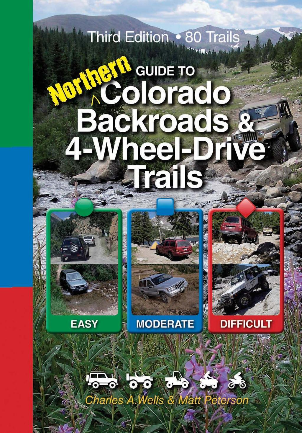
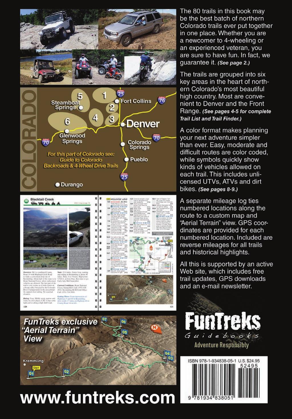
2 Published by FunTreks, Inc. P.O. Box 3127, Monument, CO Phone: Toll free Fax: (719) Web site: Copyright 2011 by FunTreks, Inc. Writing, design, photography and production by Charles A. Wells & Matt Peterson. Edited by Shelley Mayer Third Edition All rights reserved. No part of this book may be reproduced or transmitted in any form by any means, electronic or mechanical, including photocopying, recording or by any information storage and retrieval system without the written permission from the authors, except for inclusion of brief quotations in a review. Printed in China Library of Congress Control Number: ISBN: FREE trail updates, GPS downloads and newsletter available at To order additional books, call toll-free or order online at ACKNOWLEDGEMENTS Thanks to everyone with whom we traveled or met on the trails for allowing us to use pictures of you and/or your vehicles. If we published pictures that you took of us, we gave you credit at the bottom of the picture. We would also like to thank staffers and rangers at the U.S. Forest Service, BLM and other government land agencies for their time and patience answering our many questions. GUARANTEE OF SATISFACTION We guarantee you will enjoy the trails in this book. If not, or if you are dissatisfied with the book in any other way, return it to us for a full refund. Or, call our tollfree number during business hours at We promise to do whatever it takes to make you happy. DISCLAIMER Travel in Colorado s backcountry is, by its very nature, potentially dangerous and could result in property damage, injury or even death. The scope of this book cannot predict every possible hazard you may encounter. If you drive any of the trails in this book, you acknowledge these risks and assume full responsibility. You are the final judge as to whether a trail is safe to drive on any given day, whether your vehicle is capable of the journey and what supplies you should carry. The information contained herein cannot replace good judgment and proper preparation on your part. The publisher and authors of this book disclaim any and all liability for bodily injury, death or property damage that could occur to you or any of your passengers. We have made every effort to update trails to match U.S. Forest Service Motor Vehicle Use Maps (MVUMs) that were available at the time of this writing. We cannot match maps that have not yet been issued or keep up with annual changes to existing maps. We will attempt to report changes on our Web site, but make no guarantee of accuracy. You are ultimately responsible for following the latest and correct MVUM. In addition, OHV laws described in this book change constantly. We do our best to keep up with them; however, you are ultimately responsible to know the correct and latest laws. The publisher and authors of this book disclaim any and all liability for fines or other punishment that could result from being on the wrong trail or breaking the law. Note: Telephone numbers and Websites that appear in this book were verified Jan Page Topic 4 Trail List 5 Trail Finder 6 Trail Ratings Deined 6 Author s Vehicles 7 INTRODUCTION 8 Fun Trails Our Promise to You 8 What s New in This 3rd Edition 8 Web Site Updates and Downloads 8 Explanation of Vehicle Symbols 10 GPS Settings 10 All About Colorado 11 Laws, Rules, Etiquette 11 Motor Vehicle Use Maps- MVUMs 12 Safety Tips 12 Backcountry Driving Tips Winching 15 Laws for Unlicensed Vehicles 15 Checklist 17 THE TRAILS (Individual trails listed on next page) 18 Area 1 Fort Collins, Walden, Red Feather Lakes, Buckhorn Canyon 60 Area 2 Loveland, Estes Park, Raymond, Longmont 82 Area 3 Boulder, Nederland, Central City, Idaho Springs 118 Area 4 Winter Park, Empire, Grand Lake, Kremmling 152 Area 5 Steamboat Springs, Hahns Peak, Rabbit Ears Pass 166 Area 6 Vail, Glenwood Springs, Yampa, Meeker 190 Our Other Colorado Book 100 More Trails 192 Map Legend 192 Author Bios CONTENTS 2 3


3 TRAIL LIST Green = Easy, Blue = Moderate, Red = Difficult TRAIL FINDER # Name Pg. AREA 1 MAP 18 Fort Collins, Walden, Red Feather Lakes, Buckhorn Canyon 1. North Sand Hills Back Way to North Sand Hills* Deadman * Sand Creek * Deadman Lookout* 28 6.Cherokee Park, Halligan Reservoir* Kelly Flats Sevenmile Creek* Bald Mountain* Green Ridge Trail Roaring Creek Rd.* Montgomery Pass Baker Pass 44. Long Draw Reservoir * Old Flowers Moody Hill, Crystal Mountain Ballard * West White Pine Mountain* Pingree Park, Monument Gulch* Greer * 58 AREA 2 MAP 60 Loveland, Estes Park, Raymond, Longmont 21. Storm Mountain, Bear Gulch Old Fall River Pole Hill Pierson Park Johnny Park Rock Creek* Bright Trail* Bunce School, Ironclads, T-33 Site Middle St. Vrain, Coney Flats Miller Rock 80 # Name Pg. AREA 3 MAP 82 Boulder, Nederland, Central City, Idaho Spgs. 31. Lefthand OHV Area Switzerland Trail Pennsylvania Gulch* Gordon Gulch* Caribou 4WD Route Rollins Pass East West Magnolia Gross Reservoir* Apex Moon & Gamble Gulches Pickle Gulch* Kingston Peak Loch Lomond Chinns Lake Yankee Hill Nevadaville Loop* Oh-My-God, Russell Gulch* 116 AREA 4 MAP 118 Winter Park, Empire, Grand Lake, Kremmling 48. Blacktail Creek* Trough Trail Sidewinder* Sheephorn Mtn.* Williams Peak Rd Mulstay Creek* Stillwater Pass LIttle Gravel Mountain* North Supply Ck Beaver Creek, Muddy Creek* Byers Peak Rollins Pass West Jones Pass Bill Moore Lake Red Elephant Hill, Empire Loop Democrat Mountain* 150 * New Trails # Name Pg. AREA 5 MAP 152 Steamboat Springs, Hahns Peak, Rabbit Ears Pass 64. Elkhorn Mountain Ellis Jeep Trail Hahns Peak Farwell Mountain via Lost Dog* Buffalo Pass 69. Rabbit Ears Peak* 164 AREA 6 MAP 166 Vail, Glenwood Springs, Yampa, Meeker 70. Aldrich Lakes* Hay Flat* Deadhorse Loop* Red Dirt * Coffee Pot Grizzly Jeep Trail Adams Lake Transfer Trail Dotsero Crater* Bocco Mountain, Blue Lake* Red & White Mtn. 188 To find a trail, use list at left and these maps to determine in which area a trail is located, then turn to the page indicated. Detailed area maps will direct you to individual trails. 4 5


4 TRAIL RATINGS DEFINED Trail ratings are very subjective. Conditions change for many reasons, including weather and time of year. An easy trail can quickly become difficult when washed out by a rainstorm or blocked by a fallen rock. You must be the final judge of a trail s condition on the day you drive it. If any part of a trail is difficult, the entire trail is rated difficult. You may be able to drive a significant portion of a trail before reaching the difficult spot. Read each trail description carefully for specific information. Easy Gravel, dirt, clay, sand, or mildly rocky road. Gentle grades. Water levels low except during periods of heavy runoff. Full-width single lane or wider with adequate room to pass most of the time. Where shelf conditions exist, road is wide with minor sideways tilt. Clay roads, when wet, can significantly increase difficulty. Some trails can be driven in 2WD under ideal conditions. Others will need 4WD and, in some cases, low-range gearing. Author s Vehicles: (See photos) A Ford Escape: Stock 4-cyl. 4WD, no low, street tires and no off-road package. B Grand Cherokee: Stock 4WD, skid plates and tow hooks, A/T tires and CB radio. C Jeep Wrangler: Equipped with TeraFlex 3" lift with long-arm kit, 9,000 lb. Warn winch, Dana 44 rear axle; 410 gears, Tera Low 4/1 transfer case, ARB lockers front and rear, York on-board air system, Predator skid plates, High-Country rocker panel guards, Curry bumpers, Alumifl ex tie rod, Xenon extended fl airs, stock 4-liter engine, 33 x BFG A/T tires and CB radio. Jeep is a registered trademark of Chrysler Corporation. Moderate Rutted dirt or rocky road. Careful tire placement may be necessary. Some grades fairly steep but manageable if dry. Soft sand possible. Sideways tilt will require caution. Narrow shelf roads possible. Backing may be necessary to pass. Water depths passable for stock high-clearance vehicles except during periods of heavy runoff. Mud holes may be present especially in the spring. Undercarriage may scrape occasionally depending on ground clearance. Rock-stacking may be necessary in some cases. Brush may touch vehicle. Four-wheel drive, low range, and higher ground clearance required in most cases. Standard factory skid plates and tow hooks recommended on many trails. Difficult Grades can be very steep with severe ground undulation and large boulders. Sideways tilt can be extreme. Sand hills very steep with soft downslopes. Deep water crossings possible. Shelf roads extremely narrow; use caution in full-size vehicle. Passing may be difficult with backing required for long distances. Brush may scratch sides of vehicle. Body damage possible. Some trails suitable for more aggressive stock vehicles but most trails require vehicle modification. Lifts, differential lockers, aggressive articulation, and/or winches recommended in many cases. Skid plates and tow hooks required. Introduction 6 7

5 AREA 1 # Name Pg. 1. North Sand Hills Back Way to North Sand Hills Deadman Sand Creek Deadman Lookout Cherokee Park, Halligan Reservoir Kelly Flats Sevenmile Creek Bald Mountain Green Ridge Trail Roaring Creek Rd Montgomery Pass Baker Pass 44. Long Draw Reservoir Old Flowers Moody Hill, Crystal Mountain Ballard West White Pine Mountain Pingree Park, Monument Gulch Greer 58 Green = Easy, Blue = Moderate, Red = Difficult Fort Collins, Walden, Red Feather Lakes, Buckhorn Canyon Highway passes through Poudre Canyon west of Fort Collins. It is one of Colorado s most popular scenic drives. Consequently, it sees heavy traffic as hikers, bikers, fishermen, rafters, kayakers, campers and motorized recreationalists escape to the mountains on summer weekends. Established campgrounds along this major highway fill quickly and reservations are almost always necessary. Fortunately, as you head farther north and west, traffic dissipates quickly. Here you ll find solitude and lots of free dispersed camping. Plan your trip carefully, however, as gas stations are few and many miles apart. Thirteen new routes have been added to Area 1, including a little-known back way into the North Sand Hills Recreation Area. The payoff of this route is the last few miles, where a rough, steep road descends rapidly through the forest and opens to incredible views above the dunes. Two new routes, Bald Mountain and Sevenmile Creek, connect Kelly Flats to Green Ridge, forming one of the longest and most punishing hard-core trips in Colorado. 125 TO RABBIT EARS PASS Cowdrey WALDEN 125 TO WOODS LANDING, WY Rand 2 Gould TO GRANBY Grid size - 10 miles TO WOODS LANDING, WY 103 Glendevey Colorado State Forrest State Park Rocky Mountain National Park RED FEATHER LAKES Rustic 63E TO LARAMIE, WY 27 44H E Laporte 2011 FunTreks, Inc. Livermore FORT COLLINS Masonville ESTES PARK 34 LOVELAND Exit 269 Exit 257 Trail #2 allows backcountry access to North Sand Hills from the Red Feather Lakes area. 19

.")

 295-6700. Getting There: From Fort Collins, take Highway 287 northwest to Livermore and turn left on paved Red Feather Lakes 74E. Head west about 24 miles.")

![7 6.9 7.1 11.3 11.4 12.8 13.4 23.0 Zero trip odometer [Rev. Miles] Bear left off paved Red Feather Lakes 74E and head west on Deadman, Rd.. [23.0] 01 N 40 47.53 W 105 36.](/docs-images/90/101220033/images/6-5.jpg "20 Forest Service gate (closed in winter). [20.2] Picnic table on left with view to east. [18.8] Continue straight past Killpecker, F.S. 300, on left. Good staging area here. [18.3] 02 N 40 48.")
![59 W 105 40.52 North Fork Poudre F.S. Campground on right across bridge. [16.1] Continue straight. Pearl Beaver goes right to C.R. [15.9] 03 N 40 48.72 W 105 42.87 Roaring Creek, Trail #11, goes left.](/docs-images/90/101220033/images/6-6.jpg "[11.7] Continue straight. Right goes to Deadman Lookout, Trail #5. [11.6] F.S. 319 goes left to Bald Mountain and Green Ridge Trail, Trails #9 and #10. [10.2] Sand Creek on right, Trail #4. [9.")
6 Lots of dispersed camping along Deadman. Overview: Deadman is a major county road that provides access to many OHV roads in the Red Feather Lakes area. Unlicensed vehicles cannot ride on the road, but much free camping is available, so people tow in and camp near their favorite OHV trail. The road is closed in the winter from Dec. 1 through June. Rating: Easy. Wide, dusty and rocky in places, but generally traffic moves swiftly. Intermittent road damage is very common until the road dries out, usually by midsummer. Stats: Length: 23 miles. Time: 1½ to 2 hours. High point: 10,300 ft. Best time to go: Mid July-Late Sept Deadman AREA 1 map on page 18 Dowdy Lake is located on east side of town before start of Deadman (see map detail). West end of Deadman Rd. above Laramie Riv. Rd. Historical Highlight: Red Feather Lakes: A post offi ce was fi rst established in 1896 at what was then called the Perry Ranch. The area was fi rst called Westlake, but later became Red Feather Lakes. Businessmen decided to develop the area in the early 1900s. Ditches and dams were built to create many of the lakes. In 1923, an association was established to develop what has become an outstanding recreation area. About 500 people live here year round. Current Conditions: Roosevelt National Forest, Canyon Lakes R.D. Call (970) Getting There: From Fort Collins, take Highway 287 northwest to Livermore and turn left on paved Red Feather Lakes 74E. Head west about 24 miles. Just past Red Feather Lakes, turn left off pavement onto Deadman, marked C.R. (MVUM shows as C.R. 86). You can also reach Red Feather Lakes from Highway near Rustic. Head north on C.R. 69 about 3 miles. Turn left where 68C goes right to Boy Scout Camp. Go west about a mile, then follow road north another 5.5 miles to Red Feather Lakes. When you reach paved 74E, turn left for Deadman. START Zero trip odometer [Rev. Miles] Bear left off paved Red Feather Lakes 74E and head west on Deadman, Rd.. [23.0] 01 N W Forest Service gate (closed in winter). [20.2] Picnic table on left with view to east. [18.8] Continue straight past Killpecker, F.S. 300, on left. Good staging area here. [18.3] 02 N W North Fork Poudre F.S. Campground on right across bridge. [16.1] Continue straight. Pearl Beaver goes right to C.R. [15.9] 03 N W Roaring Creek, Trail #11, goes left. [11.7] Continue straight. Right goes to Deadman Lookout, Trail #5. [11.6] F.S. 319 goes left to Bald Mountain and Green Ridge Trail, Trails #9 and #10. [10.2] Sand Creek on right, Trail #4. [9.6] 04 N W Deadman ends at C.R.. Left goes to Laramie River 103 and Back Way to North Sand Hills, Trail #2. [] 05 N W Trail updates & GPS downloads at BACK WAY TO NORTH SAND HILLS Trail #2 103 Laramie River 190 TO GLENDEVEY 103 TO HWY., CHAMBERS LAKE MINI KEY Paved Unpaved 05 Easy Moderate Difficult More Trails Gray tone indicates portion described in Mileage Log Deadman TO HWY. 287 SAND CREEK ROAD Trail #4 Red Feather Trading Post and stores below all sell gas. Hill Top General Store DEADMAN LOOKOUT Trail # ROARING CREEK RD. TO BALD MTN, Trail #11 GREEN RIDGE Trails #9, 10 To Creedmore Lakes 73C Start 01 Deadman Hiawatha Hwy. Pearl Beaver North Fork Poudre F.S. Campground Grid size - 2 miles Hill Top General Store Red Feather Lake 67J 74E To Hwy., Rustic Red Feather Super Market. 300 Ramona Drive Killpecker TO CHEROKEE PARK 179 Trail #6 Prairie Divide Red Feather Trading Post Red Feather Supermarket RedFeather Lakes Gate: Closed Dec. 1 thru June DETAIL Dowdy Lake F.S. Office West Lake Start Dowdy Lake To Livermore, Hwy. 287, Ft. Collins Red Feather Lakes 01 74E 2011 FunTreks, Inc. 25


![Left ends where it is hard to turn around. Right ends at gauging station. Return to start. [] 02 N 40 53.89 W 105 24.92 Zero trip odometer EAST SIDE: From Waypoint 01, head east on 2-track road. [4.](/docs-images/90/101220033/images/7-2.jpg "1] Bear left uphill. Rocky climb begins. [1.8] 03 N 40 53.22 W 105 22.57 Stay right just before trail ends at rock outcrop with view of reservoir. Head back downhill. [1.3] 04 N 40 53.53 W 105 22.")
![26 Stay left towards reservoir. [0.8] ends at small parking area to i sh. Return to start. [] 05 N 40 53.08 W 105 21.98 Trail updates & GPS downloads at www.funtreks.](/docs-images/90/101220033/images/7-3.jpg "com Left at Waypoint 02 quickly deadends at tight spot to turn around.")
 Halligan Reservoir Overview: This is a fun little trip on a warm day with the top down.")

7 6 Cherokee Park, Halligan Reservoir Gate at start of trail. Read regulataions. Climb begins here on west side. Approaching Waypoint 05 at reservoir. AREA 1 map on page 18 Rocky ledges between Waypoints 03 and 04. Historical Highlight: Halligan Reservoir was built in 1911 for flood control and water retention for the city of Fort Collins. Due to heavy sedimentation problems, discussions have been underway to enlarge the dam to increase the size of the reservoir. START Zero trip odometer [Rev. Miles] WEST SIDE: After parking area, pass through gate and turn left. Go past toilet and follow road uphill. [2.8] 01 N W Climb steep, rocky section. [0.7] Bear right. [0.2] Stop here. Left ends where it is hard to turn around. Right ends at gauging station. Return to start. [] 02 N W Zero trip odometer EAST SIDE: From Waypoint 01, head east on 2-track road. [4.1] Bear left uphill. Rocky climb begins. [1.8] 03 N W Stay right just before trail ends at rock outcrop with view of reservoir. Head back downhill. [1.3] 04 N W Stay left towards reservoir. [0.8] ends at small parking area to i sh. Return to start. [] 05 N W Trail updates & GPS downloads at Left at Waypoint 02 quickly deadends at tight spot to turn around. Steep & rocky 02 MINI KEY Paved Unpaved Easy Moderate Difficult More Trails Gray tone indicates portion described in Mileage Log Rocky ledges TO RED MM FEATHERS, LARAMIE RIVER ROAD Start P Grid size miles Cherokee Park TO HWY FunTreks, Inc. (About 11 miles) Halligan Reservoir Overview: This is a fun little trip on a warm day with the top down. We found lots of wildflowers in mid July. Great views, especially at Waypoint 04 above the reservoir. Small challenges; not overwhelmingly difficult. Make sure you have a fishing license if you decide to fish. Closed to vehicles from September 1 to May 1. Call about regulations during hunting season. Rating: Moderate. Rocky and steep at the top, but most high-clearance SUVs should be able to do it. Easy drive to reservoir. Stats: Length: 13.8 miles if you drive everything described here. Time: About 2 hours. High point: 7,340 ft. Best time to go: June-late August. Current Conditions: Colorado Division of Wildlife, Fort Collins office. Call (970) Getting There: From Fort Collins: take Hwy. 287 northwest. Continue past Livermore about 3 miles and turn left on Cherokee Park. Follow this wide dirt road 10.6 miles west to small parking area on right. Read and follow posted regulations. From Red Feather Lakes: Take Prairie Divide north. It is first marked 67J, then changes to 179. Turn right at and go 3.6 miles to trail on left


 295-6700. Getting There: From Loveland: Take Hwy.")

![From Pingree Park : See mileage chart on Page 57. Zero trip odometer [Rev. Miles] MOODY HILL: Head uphill on steep, rocky F.S. 513. [5.1] 01 N 40 34.26 W 105 20.88 Stay left. [5.0] Steepest, rockiest section of trail.](/docs-images/90/101220033/images/8-4.jpg "[4.6] Stay left. 513A goes right to camp spot. [4.0] Continue straight. Left goes to camp spot with so-so view. [3.5] Turn left at top of long hill on F.S. 132. Right deadends at quarry. [2.")
![5] 02 N 40 33.80 W 105 22.95 Stay left on 132 where 132B goes right. Good camping here. [2.2] After passing two roads on right, you reach major intersection. Right exits downhill to Buckhorn 44H.](/docs-images/90/101220033/images/8-5.jpg "Left passes through private land. [] 03 N 40 32.73 W 105 27.79 Zero trip odometer CRYSTAL MOUNTAIN: To continue uphill to Crystal Mountain from Waypoint 03, proceed straight ahead on OHV road 344. [3.")
8 16 Moody Hill, Crystal Mountain AREA 1 map on page 18 Start of trail across from parking lot. Climbing to Waypoint 02. Overview: The trail begins and ends with fun rocky climbs. Abundant dispersed camping at various points along the route. The road to Crystal Mountain crosses a patchwork of private land. Stay on the route shown at all times to avoid landowner conflicts. Gates open June 15 and close Nov. 30 under normal conditions. Call ahead. Rating: Difficult. Steep, rocky sections are easier with lockers, but most highclearance, short-wheel-based 4x4s can manage the trail if the driver has some offroad experience. Stats: Length: 9 miles to top of Crystal Mountain. Time: Allow 4-6 hours for Novice driver gets a few pointers on fi rst climb. Climb to Crystal Mountain is steep and rocky. complete loop back to start. High point: 9,800 ft. Best time: July-September. Current Conditions: Roosevelt N.F., Canyon Lakes R.D. (970) Getting There: From Loveland: Take Hwy. 34 west and turn right on Hwy. 27 following signs to Masonville. Turn left at T in Masonville and continue another 10.7 miles to Buckhorn 44H on left. Go west 1.5 miles to F.S. 513 on left across from parking area. From Fort Collins: Follow directions for Old Flowers, Trail #15. Take Stove Prairie Rd. south 4 miles to 44H on right. From Pingree Park : See mileage chart on Page 57. Zero trip odometer [Rev. Miles] MOODY HILL: Head uphill on steep, rocky F.S [5.1] 01 N W Stay left. [5.0] Steepest, rockiest section of trail. [4.6] Stay left. 513A goes right to camp spot. [4.0] Continue straight. Left goes to camp spot with so-so view. [3.5] Turn left at top of long hill on F.S Right deadends at quarry. [2.5] 02 N W Stay left on 132 where 132B goes right. Good camping here. [2.2] After passing two roads on right, you reach major intersection. Right exits downhill to Buckhorn 44H. Left passes through private land. [] 03 N W Zero trip odometer CRYSTAL MOUNTAIN: To continue uphill to Crystal Mountain from Waypoint 03, proceed straight ahead on OHV road 344. [3.9] Intersect with larger road. Stay right. [2.4] 04 N W Bear right to stay on F.S [2.1] 05 N W Driver s choice. [1.9] 2.1 Climb obstacle then bear right. [1.8] 2.3 Stay left. Lesser road to right. [1.6] 2.9 Another tough spot. [1.0] 3.1 Stay right. [0.8] 3.4 Stay right uphill. [0.5] 3.7 Continue straight where road goes right. [0.2] 3.9 Wide spot in tight trees. Best to stop here where you can turn around. [] 06 N W continues short distance left to quartz overlook. Return the way you came. Bear left at Waypoint 03 to Buckhorn in 2.5 miles. Gate is usually open at bottom START Trail updates & GPS downloads at This obstacle on F.S. 344 can be bypassed. ROOSEVELT NATIONAL FOREST 06 44H 44H ROOSEVELT NATIONAL FOREST Seasonal gate CRYSTAL MOUNTAIN 344 Private gate B Private Land 2011 FunTreks, Inc. 132D Buckhorn 132 Stone quarry Private Land 132B 132A Grid size miles 513C H 513A 513 ROOSEVELT NATIONAL FOREST Start P 01 TO STOVE PRAIRIE ROAD MINI KEY Paved Unpaved Easy Moderate Difficult More Trails Gray tone indicates portion described in Mileage Log
9
CONTENTS. 31 THE TRAILS See next page for a complete listing of all trails and a locator map. Trail descriptions begin on page 31.
 CONTENTS Page Topic 6 Trail List 7 Trail Locator Map 8 Trails Listed by Dificulty 9 Trail Ratings Deined 11 INTRODUCTION 11 Using this Book 12 The Right Trail for You 13 About Moab 15 Utah OHV Laws and
Contents. Elephant Hill, Trail #53, Difficult.
 Page Topic 6 Trails Listed by Area 7 Trail Locator Map 8 Trails Listed by y, Ratings Defined 10 Trails Listed Alphabetically & Author s Favorites Contents 11 ITRODUCTIO 13 How to Use This Book 13 Selecting
100 Mountain & Desert Trails
 100 Mountain & Desert Trails GUIDE TO California Backroads & 4-Wheel-Drive Trails EASY MODERATE DIFFICULT Charles A.Wells & Matt eterson ublished by FunTreks, Inc..O. Box 3127, Monument, CO 80132-3127
Additional Sources for Camping Information
 Camping Additional Sources for Camping Information 100 pages Day hikes Fourteeners Weekend camping Extended Activities High Adventure Camps Council Camps Cross Country Skiing 40 pages Helpful Tools Colorado
playwinterpark.com Off The Beaten Path Hikes Hiking Recommendations for the Adventurous Hiker
 playwinterpark.com Off The Beaten Path Hikes Hiking Recommendations for the Adventurous Hiker Hike: Devil s Thumb (difficult) Length: 3.93 miles one-way Elevation: Trailhead 9609 Destination 12,236 Trailhead
MOAB Multi-Day (update ) RUN ANNOUNCEMENT
 RUN ANNOUNCEMENT") MOAB Multi-Day (update 02-06-18) RUN ANNOUNCEMENT RUN FULL NO MORE RSVPs ACCEPTED Date: March 31st to April 6th 2018 Trail Leader: Mike Wallace (714) 504-8514 Max Vehicle Limit Reached Meeting Tims: To
MOAB Multi-Day (update 02-06-18) RUN ANNOUNCEMENT RUN FULL NO MORE RSVPs ACCEPTED Date: March 31st to April 6th 2018 Trail Leader: Mike Wallace (714) 504-8514 Max Vehicle Limit Reached Meeting Tims: To
Colorado s forests are slated to lose thousands of miles of roads through the new OHV Route Designation process. DON T LET IT HAPPEN!
 Colorado s forests are slated to lose thousands of miles of roads through the new OHV Route Designation process. DON T LET IT HAPPEN! This packet identifies many roads that you may lose if you don t act.
Yankee Toys Fall Gathering 2010 Registration Form Oct. 1-3
 Yankee Toys Fall Gathering 2010 Registration Form Oct. 1-3 Thank you for attending the Yankee Toys Fall Gathering! We are excited to once again host you here in beautiful New Hampshire for a weekend of
Trail Beginning Elevation: 7553 ft The Poison Creek Trailhead is located at the end of National Forest Road 646E (NF-646E).
.") West Mountain Trails Poison Creek Trail #134 Length: 2.9 miles (4.7 km) Difficulty Horseback: A good trail for the first time west mountain rider, some steep sections Hiking: Most Difficult USGS Maps:
West Mountain Trails Poison Creek Trail #134 Length: 2.9 miles (4.7 km) Difficulty Horseback: A good trail for the first time west mountain rider, some steep sections Hiking: Most Difficult USGS Maps:
Arches of the. Sandflats Area. By Virginia Allen
 Arches of the Sandflats Area By Virginia Allen TABLE OF CONTENTS Introduction Dedication Road Log Arches 1. Perforated View Arch 2. Fee Booth Arch 3. Windsong Arch 4. Weird Arch 5. Resting Arch 6. Bike
Trail Assessment Report
 Trail Assessment Report Trail Options for the Bear Creek Canyon located in Pikes Peak Ranger District, Pike National Forest and on Colorado Springs Utility Lands Due to the presence of a unique species
If you happen to be an experienced wheeler we have made sure that there are enough exciting and challenging trails to put your skills to the test.
 Thank you for registering with NSJC Jamboree! To ensure that the NSJC Jamboree is the highlight of your summer, we have gathered together some of the most knowledgeable off-roading experts and coupled
AOTA ArtTrek Locations
 AOTA ArtTrek Locations ArtTrek is a summer-long Grand County, CO art adventure. Highlighted by snow-covered mountain vistas and rolling meadows threaded with sparkling streams and rivers, numerous sites
GOLDEN EARS PROVINCIAL PARK
 GOLDEN EARS PROVINCIAL PARK Trail Information as of October 10 th 2015 Do not underestimate the mountainous wilderness of Golden Ears Provincial Park. The combination of rugged terrain and rapidly changing
Telluride-to-Moab Alternative Singletrack Options
 Telluride-to-Moab Alternative Singletrack Options Day 1 Day 1 Alternate 1: Galloping Goose to Deep Creek. 18.4 miles, ascent 3,530ft, descent 1,388ft. This is fun, flowey, moderate to intermediate singletrack
Lava Mountain Trail Distance: Elevation Range: Trail Type: Difficulty: Season: Driving Distance: Driving Time: USGS Maps: Pros Cons
 Lava Mountain Trail Distance: 13.4 miles (including the side trip to North Star Lake) Elevation Range: 5900'-8330' Trail Type: singletrack Difficulty: moderate Season: late June-October Driving Distance:
TRIP PARTICIPANT LIST
 TRIP LEADER FORMS TRIP PARTICIPANT LIST Complete this form for all advertised club trips with copies to the club Trip Coordinator prior to the trip. Trip Name Location(s) Date(s) Trip Leader Ground Charlie
Beaver Country Trails ATV Jamboree
 Beaver Country Trails ATV Jamboree #1 Lincoln Mine Intermediate (Open to all ATVs/UTVs) 34 Miles Highlights: This ride will highlight the historic Lincoln Mining District, the first lead mine in Utah,
Table of Contents. page 3 Long term Goals Project Scope Project History. 4 User Groups Defined Trail Representative Committee. 5 Trail Users Breakdown
 Launched April 27th, 2010 1 Table of Contents page 3 Long term Goals Project Scope Project History 4 User Groups Defined Trail Representative Committee 5 Trail Users Breakdown 13 Trail Users Desires 16
GIFFORD PINCHOT NATIONAL FOREST
 GIFFORD PINCHOT NATIONAL FOREST 9341 Wright Meadow 93 Spencer Meadow Spencer Butte 4247' 30 30A 19 24 80 31C Lewis River Lower Falls 5 Quartz Creek 90 Taidnapam Falls Upper Falls 31 Spencer Peak 3861'
(west) onto Charleston Boulevard. Drive 16 miles on Charleston and turn right into Red Rock
 onto Charleston Boulevard. Drive 16 miles on Charleston and turn right into Red Rock") Hike: North Peak and Ice Box Overlook up and back Trailhead: 2.5 miles up the Rocky Gap Road not mark Distance: 5 miles round trip Elevation gain: 2,694 feet Elevation Peak: 7,094 feet Time: 3 to 5 hours
Hike: North Peak and Ice Box Overlook up and back Trailhead: 2.5 miles up the Rocky Gap Road not mark Distance: 5 miles round trip Elevation gain: 2,694 feet Elevation Peak: 7,094 feet Time: 3 to 5 hours
Trail Phasing Plan. Note: Trails in the Clear Creek Canyon area (Segments will be finalized in the future to minimize wildlife impacts
 Note: Trails in the Clear Creek Canyon area (Segments 2 5 and a future JCOS connection) will be finalized in the future to minimize wildlife impacts Trail Phasing Plan P Parking 3 Easy Trail Intermediate
Crystal Lake Area Trails
 Lake Area Trails Welcome to the Lake area of the Big Snowy Mountains! This island mountain range in central Montana features peaks reaching to 8,600 feet and long, high ridges from which vistas of the
Road and Trail Report 05/25/2015
 U.S.D.A. FOREST SERVICE KETCHUM RANGER DISTRICT 206 SUN VALLEY ROAD P.O. BOX 2356 KETCHUM, ID 83340 (208) 622-5371 Road and Trail Report 05/25/2015 Trail and Road conditions remain much the same as last
Section 7: Pick Up Where You Left Off! S-Tree Road over the Todd Road
 2018 TRACE NOTES Helpful information for your adventure on Section 7 of the Hiker Challenge. Start Point S-Tree Rd. End Point Intersection Todd Rd. / Hale Ridge Rd. WEATHER DECISION Weather Alert!!!! Potential
ASRA 2018 Hike Schedule
 ASRA 2018 Hike Schedule Date/Day Destination Hike Info Meeting Info Leader Feb 10, Saturday Stagecoach and 9:00 at the Confluence kiosk. Manzanita trails Parking fee required. We ll hike along the trail
Beaver Creek State Park
 GENERAL INFORMATION Name of Park/Forest/Facility: Beaver Creek State Park County: Columbiana (St. Clair Township) Address: 12816 Sprucevale Road (ie County Rd 428) (street #, city) East Liverpool, Ohio
U.S.D.A. FOREST SERVICE KETCHUM RANGER DISTRICT 206 SUN VALLEY ROAD P.O. BOX 2356 KETCHUM, ID (208)
") U.S.D.A. FOREST SERVICE KETCHUM RANGER DISTRICT 206 SUN VALLEY ROAD P.O. BOX 2356 KETCHUM, ID 83340 (208) 622-5371 Road and Trail Report 05/8/2015 More trails opened in Greenhorn this week. Only high elevation
U.S.D.A. FOREST SERVICE KETCHUM RANGER DISTRICT 206 SUN VALLEY ROAD P.O. BOX 2356 KETCHUM, ID 83340 (208) 622-5371 Road and Trail Report 05/8/2015 More trails opened in Greenhorn this week. Only high elevation
Non-motorized Trail Plan & Proposal. August 8, 2014
 Town of Star Valley Ranch, Wyoming and the Star Valley Ranch Association in partnership with the USDA Forest Service, Bridger-Teton National Forest, Greys River Ranger District Non-motorized Trail Plan
Cr./Left Fork of Boulder Creek/Horse Creek Made it 2.2 miles from Hwy on Left fork of Boulder Creek. Heavy washout;
 Road Inspector Inspection Inspection Date North Fork Mark M. 6/7 Open Boulder Cr. Helitack 6/16 no signs on either section of Boulder Cr. 2) we were able to make it to the creek crossing on Boulder Cr.
A DESERT CAMPING GUIDE FOR ANZA BORREGO DESERT STATE PARK
 A DESERT CAMPING GUIDE FOR ANZA BORREGO DESERT STATE PARK With over 500,000 acres of beautiful terrain, Anza Borrego Desert State Park offers endless opportunities for Boy Scout Troops, Venture Crews and
Hiking Las Vegas.com
 Hike: Mt. Wilson via First Creek Canyon route Trailhead: First Creek marked Distance: 10 miles up and back Elevation gain: 3,400 feet Elevation of Peak: 7,070 feet Time: 7 to 9 hours (up and back) Difficulty:
A Publication of Friends of Sleeping Bear Dunes
 A Publication of Friends of Sleeping Bear Dunes 2014, Friends of Sleeping Bear Dunes, P.O. Box 545, Empire, MI 49630 www.friendsofsleepingbear.org info@friendsofsleepingbear.org Learn more about the Friends
SIMON CANYON AREA OF CRITICAL ENVIRONMENTAL CONCERN (ACEC)
") SIMON CANYON AREA OF CRITICAL ENVIRONMENTAL CONCERN (ACEC) Activities: Facilities: Season / Hours: Description: Hiking, backpacking, fishing, picnicking, watchable wildlife. A graveled parking area, picnic
SIMON CANYON AREA OF CRITICAL ENVIRONMENTAL CONCERN (ACEC) Activities: Facilities: Season / Hours: Description: Hiking, backpacking, fishing, picnicking, watchable wildlife. A graveled parking area, picnic
Rogue Gorge (Mt. Stella) Roadless Area-- T30S R3E (primarily in portions of Sections 23, 26, 33, 34 & 35)
 Roadless Area-- T30S R3E (primarily in portions of Sections 23, 26, 33, 34 & 35)") Rogue Gorge (Mt. Stella) Roadless Area-- T30S R3E (primarily in portions of Sections 23, 26, 33, 34 & 35) Rogue River-Siskiyou National Forest--High Cascades Ranger District Upper, higher elevation trail
Rogue Gorge (Mt. Stella) Roadless Area-- T30S R3E (primarily in portions of Sections 23, 26, 33, 34 & 35) Rogue River-Siskiyou National Forest--High Cascades Ranger District Upper, higher elevation trail
West Trails Trek Guide. Chief Pontiac Trail Credential Hikes
 West Trails Trek Guide Kensington Start Edition Chief Pontiac Trail Credential Hikes RDS.WTW.110609 WP# Dist. Accum. Dist. Accum. Feet Miles Meters Meters 1 0 0.0 0 0 2 410 0.1 125 125 3 164 0.1 150 275
PRIEST LAKE TRAILS. More information contact: Priest Lake Ranger District
 PRIEST LAKE TRAILS The varying terrain in the Priest Lake area ranges from river bottoms with an elevation of 2,600 to 7,500 ft. Valley bottoms, dense forests, meadows and occasional clearings and barren
Androscoggin River Trail Access Sites. North Woods. 168 miles from its source at Lake Umbagog to Merrymeeting Bay
 Androscoggin River Trail Access Sites North Woods 168 miles from its source at Lake Umbagog to Merrymeeting Bay Trail Under Construction More than 40 Public Access Sites Available Androscoggin River Watershed
HAVE A GREAT HIKE AND ENJOY!
 BAKER LAKE HIKE #5634 & #234 (Moderate to Strenuous walking sticks recommended) DIRECTIONS TO TRAILHEAD: From Triple Creek s driveway, turn left on West Fork Road and drive about 1.3 miles (just past mile
Cherokee Hiking Club Trail Blurb
 Cherokee National Forest Trail #164 Distance: 6.2 miles Elevation Change: 2280 feet High Point: 3692 feet (Waucheesi Mountain) Low Point: 1412 feet (Wildcat Creek) Trail Rating: Moderately Strenuous (NW
ABOUT THE PARKS NANTAHALA NATIONAL FOREST MOUNTAINS NATIONAL PARK CHEROKEE NATIONAL FOREST PISGAH NATIONAL FOREST GREAT SMOKY HIKING TRAILS
 ABOUT THE PARKS GREAT SMOKY MOUNTAINS NATIONAL PARK NANTAHALA NATIONAL FOREST CHEROKEE NATIONAL FOREST PISGAH NATIONAL FOREST GREAT SMOKY MOUNTAINS NATIONAL PARK Straddling the border between North Carolina
OMH Trail Data / History
 Lake Sylvia Loop Ouachita National Forest (AR) This is a five-mile loop with several variations for Saturday hikes. The basic loop starts at Lake Sylvia campground and goes south to meet the Ouachita Trail
CIEC 9 PEAKS AWARD SUPPLEMENT POSSIBLE ROUTES FOR THE 9 PEAKS AWARD TRIP
 CIEC 9 PEAKS AWARD SUPPLEMENT POSSIBLE ROUTES FOR THE 9 PEAKS AWARD TRIP As you plan your trip, be aware of 3 regulations in this wilderness: 1. Camp only in designated campsites. 2. No campfires allowed.
Difficult Run Stream Valley Park
 Difficult Run Stream Valley Park The more intense mountain bikers have known about for Difficult Run for some time. Equestrians have known it longer. Eight miles of unpaved trail, the Rails to River Trail
Hiking Las Vegas.com
 Hike: Juniper Peak up and back Trailhead: Oak Creek Canyon marked Distance: 5.5 miles round trip Elevation gain: 2,200 feet Elevation peak: 6,109 feet Time: 4 to 5 hours - Up and back Difficulty: 3 Danger
BRR Leg 1 (4.0 miles, Easy)
") BRR Leg 1 (4.0 miles, Easy) Min 3881 Max 4948 Ascent +36 Descent -1027 0.0 Start (Grayson Highlands State Park Visitor Center) 4.0 Grayson Highlands State Park Office & Gate, on L (EZ 1) Leg Notes: Minimal
BRR Leg 1 (4.0 miles, Easy) Min 3881 Max 4948 Ascent +36 Descent -1027 0.0 Start (Grayson Highlands State Park Visitor Center) 4.0 Grayson Highlands State Park Office & Gate, on L (EZ 1) Leg Notes: Minimal
RECREATION. Seven issues were identified that pertain to the effects of travel management on outdoor recreation within portions of the project area.
 RECREATION Seven issues were identified that pertain to the effects of travel management on outdoor recreation within portions of the project area. OPPORTUNITIES FOR SOLITUDE / QUIET TRAILS. One attraction
Death Valley. Exploration. November 1-3, Mark A. Smith Off-Roading Inc. Jeep Jamboree USA 2776 Sourdough Flat Georgetown, CA 95634
 Death Valley Exploration November 1-3, 2018 Mark A. Smith Off-Roading Inc. Jeep Jamboree USA 2776 Sourdough Flat Georgetown, CA 95634 Death Valley Exploration November 1-3, 2018 Due to the unpredictable
Hiking Trail Descriptions
 Hiking Trail Descriptions For ye shall go out with joy. And be led forth with peace. The mountains and the hills shall break forth before you in singing. And all the trees of the fields shall clap their
Tiger Mountain State Forest:
 98 60 hikes within 60 miles: SEATTLE 20 Tiger Mountain State Forest: West Tiger Mountain Three Loop i KEY AT-A-GLANCE INFORMATION Length: 5.1 miles round-trip Configuration: Loop Difficulty: Moderate difficult
Staples Lookout to Mt Wondabyne loop
 Staples Lookout to Mt Wondabyne loop 4 hrs 3 mins 1.8 km Circuit Hard track 337m This walk starts and finishes at Staples Lookout, on Woy Woy Rd. The walk follows sections of the Great North Walk around
YOSEMITE ON HORSEBACK: THREE RIDES ALONG TIOGA ROAD Cindy Casey White Wolf Area, May Lake Loop, Ragged Peak Loop
 YOSEMITE ON HORSEBACK: THREE RIDES ALONG TIOGA ROAD Cindy Casey White Wolf Area, May Lake Loop, Ragged Peak Loop The high country along Tioga Road presents us with some of the most dramatic scenery in
Chapter 2: Entire US287 Corridor
 Chapter 2: Entire US287 Corridor The US287 Study Area spans four incorporated jurisdictions and two counties. Due to the length and density of infrastructure along the US287 Study Area, corridor-wide maps
White Horse. For your own safety warn the MCA Coastguard Helicopter (01305) They have been known to low fly in this area
 They have been known to low fly in this area") Site Code 2.078 OS Grid Ref: SY 715 844 (Map 194) GPS: N50:39.514 Owned and farmed by: Nearest Phone: Casualty Units: W2:24:273 P & J Critchell Farm Osmington 01305 834314 Broadmayne or Sutton Poyntz County
Site Code 2.078 OS Grid Ref: SY 715 844 (Map 194) GPS: N50:39.514 Owned and farmed by: Nearest Phone: Casualty Units: W2:24:273 P & J Critchell Farm Osmington 01305 834314 Broadmayne or Sutton Poyntz County
Minimum suggested standards for handling food grade hoses during tank washing. cargotanksafety.org
 Click to CTRMC edit Master Presents title style Minimum suggested standards for handling food grade hoses during tank washing cargotanksafety.org Cargo Tank Risk Management Committee The Cargo Tank Risk
CPW Extended Office Hours - Big Game Rifle Seasons October 13, November 18, 2018
 WILDLIFE OFFICES DATES/HOURS EXCEPTIONS BRUSH OFFICE 28167 CoRd T Brush, CO 80723 (970) 842-6300 COLORADO SPRINGS SOUTHEAST REGIONAL OFFICE 4255 Sinton Road Colorado Springs, CO 80907 (719) 227-5200 Closed
Rocky Mountain National Park Hiking Map By Trails Illustrated Maps
 Rocky Mountain National Park Hiking Map By Trails Illustrated Maps 10 Great Hikes for Families with Kids in Estes Park, Colorado - Choose from plenty of great family hikes in Rocky Mountain National park.
Table Mesa. 4 th Table Mesa Jeep Jamboree. February 28 March 2, 2019 Anthem, Arizona Trail Rating 2 8
 Table Mesa 4 th Table Mesa Jeep Jamboree February 28 March 2, 2019 Anthem, Arizona Trail Rating 2 8 Your Adventure Consultant is Ty Devereaux 530.333.1462 ty@jeepjam.com Polices & Reminders For All 2019
San Juan Hut Systems Telluride To Moab Route Description. Adventure without the weight
 San Juan Hut Systems Telluride To Moab Route Description Due to the inaccuracies caused by varying calibrations in odometers, you may notice some inaccuracies in the mileages listed for the Standard Route
3rd Table Mesa Jeep Jamboree March 1-3, 2018
 3rd Table Mesa Jeep Jamboree March 1-3, 2018 Adventure Consultant: Ty Deveraux Phone: 530.333.1462 Email: ty@jeepjam.com 3rd Table Mesa Jeep Jamboree Anthem, Arizona March 1 3, 2018 Trail Rating 4 9 Policies
APPENDIX D: SUSTAINABLE TRAIL DESIGN. APPENDICES Town of Chili Parks and Recreation Master Plan Update
 APPENDIX D: SUSTAINABLE TRAIL DESIGN APPENDICES Town of Chili Parks and Recreation Master Plan Update Sustainable Trail Construction Sustainable trails are defined by the US Forest Service as trails having
Rock Creek Park, MD - Lake Needwood
 ock Creek Park, MD - Lake Needwood Lake Needwood, is a reservoir located at the end of the north end of the ock Creek hiker-biker trail. At the other end, ock Creek empties into the Potomac iver near Thompson
Asheville & WNC Hikes
 Asheville & WNC Hikes Amazingly, we have 3,000+ miles of free public hiking trails near Asheville, including 1,600 miles in the Pisgah and Nantahala National Forests, 850 miles in Great Smokey Mountains
Date Name Trail Segment Conditions, Hazards and General Notes on Trails
 Trail Reports for Sawtooth NRA ***Unless otherwise reported-expect high creeks, snow levels at 7900 ft. and trees on trails. Due to high winds in the area, if trees were previously reported removed there
Route Combo) Mt. Bierstadt - Bierstadt, Sawtooth, Evans
 Mt. Bierstadt - Bierstadt, Sawtooth, Evans") Climbing 14ers can be very dangerous, please read the Mountaineering Safety Page and make sure you have a map+compass and can use them effectively, without the help of electronic devices. Route Combo)
Climbing 14ers can be very dangerous, please read the Mountaineering Safety Page and make sure you have a map+compass and can use them effectively, without the help of electronic devices. Route Combo)
Witte Museum Tour Meyers Spring Ranch Tour Saturday, September 1, a.m. - 4 p.m.
 Witte Museum Tour Meyers Spring Ranch Tour Saturday, September 1, 2018 10 a.m. - 4 p.m. This tour is limited to 35 participants (Ages 12 and up) All minors must be accompanied by a parent or legal guardian.
Witte Museum Tour Painted Shelter on the Rio Grande River Saturday June 2, :30 A.M. 3:00 P.M.
 Witte Museum Tour Painted Shelter on the Rio Grande River Saturday June 2, 2018 9:30 A.M. 3:00 P.M. This tour is limited to 35 participants (Ages 12 and up) All minors must be accompanied by a parent or
Marilla Reservoir to Chestnut Ridge via Marilla Trails and Bullis Hollow Trail east to west
 USGS topographic maps useful to this hike are the Bradford and Stickney 7.5 minute sectionals. These notes are designed to assist in identifying distance and location using geophysical and man-made characteristics
MOAB peopleforbikes.org/e-bikes
 emtb ADVENTURE MAPS MOAB peopleforbikes.org/e-bikes OVERVIEW Moab, Utah is a world-class mountain bike destination known for its vast, red sandstone landscapes nestled below the rising peaks of the La
Junior Ranger Guide. Recommended for Ages Photo Charlie Johnson
 Junior Ranger Guide Recommended for Ages 7-12 Photo Charlie Johnson 1 Hi! I m Barry the Bear and I m excited to help you become a Larimer County Junior Ranger! Rangers keep parks and open spaces safe for
Oceano Dunes SVRA (Pismo Beach)
") SCLR Event Oceano Dunes SVRA (Pismo Beach) September 19-20, 2009 When: Where: What: September 19 nd and 20 th Oceano Dunes SVRA Pismo Beach, California Sand Dunes, camping, games, food, driving challenges,
SCLR Event Oceano Dunes SVRA (Pismo Beach) September 19-20, 2009 When: Where: What: September 19 nd and 20 th Oceano Dunes SVRA Pismo Beach, California Sand Dunes, camping, games, food, driving challenges,
1. Drive to Lake Cowichan via Highway 18 (which connects to the Trans-Canada Highway just north of Duncan)
") Driving Instructions to the Walbran Valley via Lake Cowichan (updated July 2018) 1. Drive to Lake Cowichan via Highway 18 (which connects to the Trans-Canada Highway just north of Duncan) 2. At the traffic
Driving Instructions to the Walbran Valley via Lake Cowichan (updated July 2018) 1. Drive to Lake Cowichan via Highway 18 (which connects to the Trans-Canada Highway just north of Duncan) 2. At the traffic
American Conservation Experience
 ACE Project Report For Tonto National Forest, Arizona Trail Association and Arizona State Parks Title of Project: 4 Peaks Trail Maintenance Award Contract Number: ASP NM11021 Project Partner: Paul Burghard
HUNTING PROPERTIES Bearpaw Trail Hand constructed with reclaimed timbers from a historic Stagestop.
 $4,500,000 #139289 428.0 AC $2,500,000 #138964 113.5 AC $24,9500,000 #137591 9,000.0 AC 8855 Bearpaw Trail Includes a 3 acre lake and borders Routt National Forest. 8925 Bearpaw Trail Hand constructed
Kuruwita Erathna Trail to Sri Pada (Adam s Peak)
") Kuruwita Erathna Trail to Sri Pada (Adam s Peak) Trail Difficulty: Easy Moderate Strenuous Tough Trail Head: Adevikanda, Erathna (near entrance to mini-hydro power plant) Nearest Town: Erathna Nearest
Kuruwita Erathna Trail to Sri Pada (Adam s Peak) Trail Difficulty: Easy Moderate Strenuous Tough Trail Head: Adevikanda, Erathna (near entrance to mini-hydro power plant) Nearest Town: Erathna Nearest
UTAH 2016 CANYONLANDS
 UTAH 2016 CANYONLANDS THE WHITE RIM TRAIL MAY 17, 2016 We left the cabin at 7:30 a.m. The goal was to get to Great Basin National Park that night. We took Highway 6 towards Tonopah and decided to go north
Stephens State Park Trails
 TRAILS OF ALLAMUCHY MOUNTAIN & STEPHENS STATE PARKS Allamuchy Mountain and Stephens State Parks contain 28 marked trails providing access to diverse landscapes for walking, hiking, biking, bird-watching,
Ranch. Creek. Cow. Mountain
 Cow Creek Mountain Ranch Situated along the southwestern hills of the Laramie Mountains and the Medicine Bow-Routt National Forest in northeastern Albany County, Wyoming. 58 E. Benteen Street Buffalo,
Other Agencies and Organizations
 Daniel Boone National Forest 1700 Bypass Road WInchester, KY 40391 859-745-3100 Location Northern terminus is near Morehead, Kentucky. Southern terminus is located in the Big South Fork NRRA in Tennessee.
LOWER SPRING CANYON - CAPITOL REEF
 LOWER SPRING CANYON - CAPITOL REEF Rating: Moderate Hike Length: 5-7 hours (10-11 miles) Gear: Standard Hiking Gear Maps: Fruita, UT; Twin Rocks, UT; Water: A filterable spring a bit over 1/2 way. Recommend
Girrakool to Wondabyne station
 Girrakool to Wondabyne station 4 hrs Hard track 9.5 km One way 4 438m This walk starts from the Girrakool picnic area and winds south, through the Brisbane Waters National Park. The walk crosses some long
UTV BLADE MOUNT HARDWARE
 1701 38TH AVE W PO BOX 257 SPENCER, IA 51301 PHONE: 712-262-4191 FAX: 712-262-0248 SERVICE: 800-841-2222 E-MAIL: ccac@cyclecountry.com UTV BLADE MOUNT HARDWARE For the KUBOTA RTV900 OWNER S MANUAL MODEL
Date Name Trail Segment Conditions, Hazards and General Notes on Trails
 Trail Reports for Sawtooth NRA ***Unless otherwise reported-expect high creeks, snow levels at 7500 ft. and trees on trails. Due to high winds in the area, if trees were previously reported removed there
Kimmeridge. Owned by: Smedmore Estates Wind Direction SSW W (210 to 270 ) Best: SW (240 )
 Best: SW (240 )") Site Code 2.073 OS Grid Ref: SY 926 795 (Map 194) GPS: N50:36.909 W2:06.357 Owned by: Smedmore Estates Wind Direction SSW W (210 to 270 ) Best: SW (240 ) Top farmed by: Mr J.Hole Farm 01929 480936 Bottom
Site Code 2.073 OS Grid Ref: SY 926 795 (Map 194) GPS: N50:36.909 W2:06.357 Owned by: Smedmore Estates Wind Direction SSW W (210 to 270 ) Best: SW (240 ) Top farmed by: Mr J.Hole Farm 01929 480936 Bottom
Weston County, Wyoming
 The Sweet 200-Acre Property Weston County, Wyoming A unique opportunity to own a little piece of the old West, where one can experience unparalleled scenery, adventure and history walk in the footsteps
Route #2) Mt. Massive - Southwest Slopes
 Mt. Massive - Southwest Slopes") Route #2) Mt. Massive - Southwest Slopes Difficulty: Class 2 Ski: Advanced, D6 / R2 / III Exposure: Summit Elevation: Trailhead Elevation: Elevation Gain: Round-trip Length: Trailhead: County Sheriff:
Route #2) Mt. Massive - Southwest Slopes Difficulty: Class 2 Ski: Advanced, D6 / R2 / III Exposure: Summit Elevation: Trailhead Elevation: Elevation Gain: Round-trip Length: Trailhead: County Sheriff:
Paiute Trail Hatfield-McCoy Highwood Mountains
 Paiute Trail Hatfield-McCoy Highwood Mountains Located in Central Utah Main trail is 238 miles 550 miles of designated side trails Links 16 communities in 4 counties Ranges from 5,200 to 11,500 feet Great
Skiing and Snowshoes on Un-groomed Fernan Saddle Terrain
 Skiing and Snowshoes on Un-groomed Fernan Saddle Terrain Three ski or snowshoe routes are available from the Fernan Saddle Parking Lot which either do not cover routes ordinarily groomed for snow machine
BRR Leg 1 (3.9 miles, Easy)
") BRR Leg 1 (3.9 miles, Easy) Min 3901 Max 4919 Ascent +21 Descent -1031 0.0 Start (Grayson Highlands State Park Visitor Center) 3.9 Grayson Highlands State Park Office & Gate, on R (EZ 1) Leg Notes: Minimal
BRR Leg 1 (3.9 miles, Easy) Min 3901 Max 4919 Ascent +21 Descent -1031 0.0 Start (Grayson Highlands State Park Visitor Center) 3.9 Grayson Highlands State Park Office & Gate, on R (EZ 1) Leg Notes: Minimal
Black Hill Regional Park, Little Seneca Lake
 Black Hill Regional Park, ittle Seneca ake ittle Seneca ake, in Black Hill Regional Park, is a reservoir created after a previous drought struck the Washington area. The park is under Maryland-National
Date Name Trail Segment Conditions, Hazards and General Notes on Trails
 Trail Reports for Sawtooth NRA ***Unless otherwise reported-expect high creeks, snow levels at 7900 ft. and trees on trails. Due to high winds in the area, if trees were previously reported removed there
GATEWAY PHASE 2. U.S. Forest Service and the Mount Shasta Trails Association
 GATEWAY PHASE 2 U.S. Forest Service and the Mount Shasta Trails Association PROJECT DEVELOPMENT Brief history - Gateway Phase 1 - IMBA conceptual plan - BikeShasta: concert series - USFS & MSTA partnered
Piestewa Peak/Dreamy Draw Trail Guide
 Piestewa Peak/Dreamy Draw Trail Guide Trail #1A - Perl Charles Memorial Trail Length: 4.8 miles Elevation: 2,200 ft. - 1,340 ft. Difficulty: Moderate to difficult The Perl Charles trailhead is located
Mt Kuring-gai Track to Berowra station
 Mt Kuring-gai Track to Berowra station 4 hrs 15 mins 9.7 km One way Hard track 4 553m This walk explores three valleys, with great displays of wild flowers in spring, and some nice sandstone overhangs.
Texas Spur. 15 th Texas Spur Jeep Jamboree. March 14-16, 2019 Llano, Texas Trail Rating 6 9
 Texas Spur 15 th Texas Spur Jeep Jamboree March 14-16, 2019 Llano, Texas Trail Rating 6 9 Your Adventure Consultant is Shawn Gulling 530.333.4002 shawn@jeepjam.com Polices & Reminders For All 2019 Jeep
beach. Make the ford and follow the trail out to the junction with Red Creek Tr in an open grassy area.
 Description: This is a moderate to slightly strenuous 22.8 mile backpack (add 2.6 miles if you do the packless out and back to the Lion s Head) that will have you exploring nearly every thing that is The
Trail Notes Palouse Region Hikes
 Trail Notes Palouse Region Hikes Campus Recreation 875 Perimeter Drive MS 1230 Moscow, Idaho 83844-1230 Ph: 208.885.6810 Rentals: 208.885.6170 Fax: 208.885.6879 uidaho.edu/outdoorprogram 0 PALOUSE REGION
Welcome to Natural Bridge
 Welcome to Natural Bridge Richard R. Randolph IV www.r4capital.com Www.r4land.com 205-879-5517 Work 205-413-8805 Fax 6 Carla Circle Birmingham, AL 35213 rich@r4capital.com Introduction NATURAL BRIDGE 160
SDTrucksprings. Indiana Off-roading/4x4 Guide Copyright 2015 We Specialize In:
 SDTrucksprings Indiana Off-roading/4x4 Guide Copyright 2015 We Specialize In: Helper Springs Air Bags Leaf Springs Body Lift Kits Coil Springs Timbren Kits Hellwig Springs Lift Blocks And More! Visit www.sdtrucksprings.com
MONTANA ROCKHOUNDING MONTANA: 4 DAYS. Calgary Rock and Lapidary Club - You Drive Field Trip. A Rockhounder s Dream
 Calgary Rock and Lapidary Club - You Drive Field Trip MONTANA A Rockhounder s Dream ROCKHOUNDING MONTANA: 4 DAYS Crystal Park, Calvert Mine, Argo Mine Just a few hours south of Calgary is Montana, the