Contents. Elephant Hill, Trail #53, Difficult.
|
|
|
- Jesse Fisher
- 6 years ago
- Views:
Transcription
1

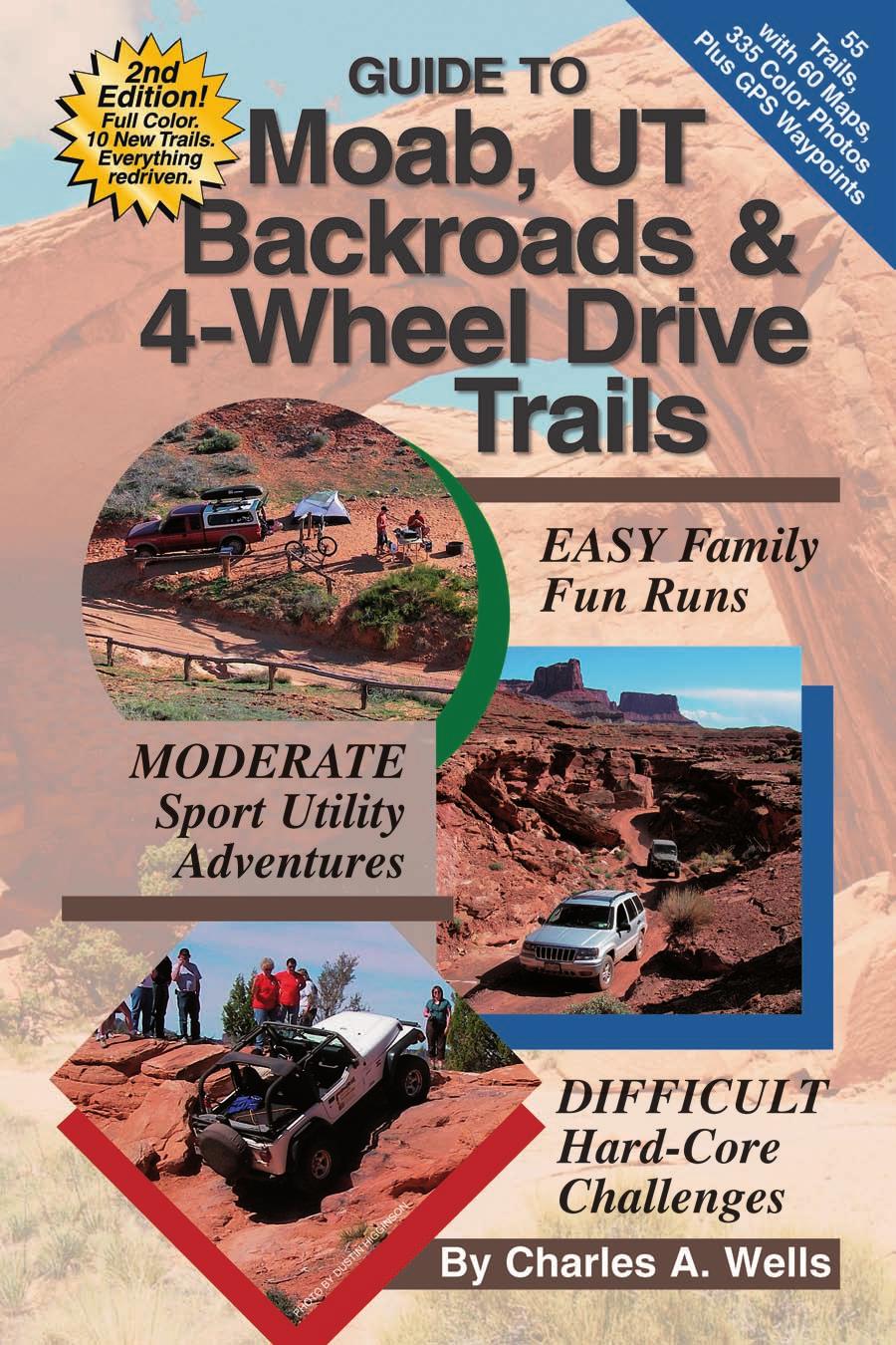
2 Page Topic 6 Trails Listed by Area 7 Trail Locator Map 8 Trails Listed by y, Ratings Defined 10 Trails Listed Alphabetically & Author s Favorites Contents 11 ITRODUCTIO 13 How to Use This Book 13 Selecting the Right Trail for Your Vehicle 14 Moab and Its Backcountry 16 Moab Easter Jeep Safari 16 Safety Tips 18 Desert Survival 20 Checklist 21 Your Responsibilities as a Backcountry Driver 23 Canyonlands ational Park 24 Arches ational Park 24 ational Forest Service & Bureau of Land Management 25 Route-Finding Tips 25 Backcountry Driving Lessons 31 Other Activities, Final Comments 32 Map Legend 33 THE TRAILS (Individual trails listed on next page) 34 Area 1- orthwest Moab & Arches ational Park 74 Area 2- Central Moab 140 Area 3- East Moab & Manti-La Sal ational Forest 172 Area 4- Southwest Moab & Canyonlands ational Park 214 Extreme Trails 215 APPEDIX 216 Glossary 217 Helpful Books and Maps 218 Addresses & Phone umbers 220 Moab 4x4 Clubs, Safari Contact Information 221 About the Author 222 ATV Trails Guide, Moab, UT Elephant Hill, Trail #53,. 4 5
 46 5. Hidden Canyon Overlook (M) 50 6. Hidden Canyon (E) 52 7. Bartlett Overlook (D) 56 8. Bartlett Wash (E) 58 9. Sevenmile Rim (D) 62 10. Rainbow Terrace (M) 64 11.")
3 Trails Listed by Area Pg. o./trail, Rating (, Mod., Diff.) 34 AREA 1 orthwest Moab & Arches ational Park Book Cliffs, Sego Canyon (E) White Wash Sand Dunes (M) Tower Arch (M) Tusher Tunnel (E) Hidden Canyon Overlook (M) Hidden Canyon (E) Bartlett Overlook (D) Bartlett Wash (E) Sevenmile Rim (D) Rainbow Terrace (M) Secret Spire, Dellenbaugh Tunnel (M) Spring Canyon Point (E) Spring Canyon Bottom (E) Hey Joe Canyon (M) Mineral Point (E) 74 AREA 2 Central Moab Gemini Bridges (E) Metal Masher (D) Long Canyon (E) Bull Canyon (M) Gold Bar Rim (D) Poison Spider Mesa (D) Golden Spike (D) Cliff Hanger (D) Hurrah Pass (E) Moab Rim (D) Pritchett Canyon (D) Kane Creek Canyon (D) Behind the Rocks (D) Strike Ravine (D) Picture Frame Arch (E) Flat Iron Mesa (D) Hell s Revenge (D) Fins & Things (D) Sand Flats (E) Steel Bender (D) 6 Pg. o./trail, Rating (, Mod., Diff.) 140 AREA 3 East Moab & Manti-La Sal ational Forest Onion Creek, Fisher Towers (E) Dome Plateau (M) Top of the World (D) Dolores Overlook (E) Rose Garden Hill (D) Thompson Canyon, Polar Mesa (M) Castleton Gateway (E) Geyser Pass (E) La Sal Pass (M) 172 AREA 4 Southwest Moab & Canyonlands ational Park Potash, Shafer Switchbacks (E) White Rim (M) Lathrop Canyon (M) Chicken Corners (M) Lockhart Basin (D) Lockhart Canyon (M) Canyon Rim Overlooks (E) Overlook (M) Elephant Hill (D) Lavender Canyon (M) Beef Basin (E) 214 Extreme Trails Photos, directions and GPS locations: Area BFE Potato Salad Hill Rusty ail For information on ATV trails, see page 222. SALT LAKE CITY 70 Green Ruby Ranch Green Salt Lake City 2 AREA 1 Pg. 34 CAYOS UTAH Area Detailed Below Floy Exit 175 Crescent Junction Exit 182 Blue Hills Rd. Dubinky Well DEAD 15 HORSE POIT STATE Trail Locator Map Thompson Springs Exit 187 Trails Trails Trails See individual area maps for more detail. ote: Exit numbers have changed recently. Correct as of Jan ARCHES Moab AREA 4 Pg GRAD JUCTIO Exit 204 eedles Overlook Cisco 36 Castleton/ Gateway AREA 2 Pg. 74 Exit La Sal To Monticello Dewey Bridge 41 La Sal Mtn. Loop AREA 3 Pg MATI- LA SAL FOREST COLORADO 0 10 miles 7
4 Trails Listed by y Trails are grouped into three major categories: easy, moderate and difficult. Within each group, trails at the top of the list are easier than at the bottom. If you drive a trail and find it too easy, try one lower on the list. Conversely, if you find a trail too difficult, try one higher on the list. You may have to skip several trails on the list to find a significant difference. Trail Ratings Defined Trail ratings are very subjective. Conditions change for many reasons, including weather and time of year. An easy trail can quickly become difficult when washed out by a rainstorm or blocked by a fallen rock. You must be the final judge of a trail s condition on the day you drive it. If any part of a trail is difficult, the entire trail is rated difficult. You may be able to drive a significant portion of a trail before reaching the difficult spot. Read each trail description carefully for specific information. 8 * trail Go to * updates Easier More Pg. o./trail Castleton Gateway Sand Flats Bartlett Wash Geyser Pass Onion Creek, Fisher Towers Spring Canyon Point Canyon Rim Overlooks Book Cliffs, Sego Canyon Hurrah Pass Picture Frame Arch Tusher Tunnel Hidden Canyon Mineral Point Gemini Bridges Beef Basin Dolores Overlook Long Canyon Spring Canyon Bottom Potash Rd., Shafer Switchbacks : Gravel, dirt, clay, sand, or mildly rocky road. Gentle grades. Water levels low except during periods of heavy runoff. Full-width single lane or wider with adequate room to pass most of the time. Where shelf conditions exist, road is wide and well-maintained with minor sideways tilt. Four-wheel drive recommended on most trails but some are suitable for twowheel drive under dry conditions. Clay surface roads, when wet, can significantly increase difficult or may be impassable. Pg. o./trail Lockhart Canyon Thompson Canyon, Polar Mesa Lavender Canyon Overlook White Wash Sand Dunes Secret Spire, Dellenbaugh Tun White Rim La Sal Pass Tower Arch Lathrop Canyon Chicken Corners Hidden Canyon Overlook Bull Canyon Rainbow Terrace Dome Plateau Hey Joe Canyon : Rutted dirt or rocky road suitable for most sport utility vehicles. Careful tire placement is often necessary. Four-wheel drive, low range, and high ground clearance required. Standard factory skid plates and tow hooks recommended on many trails. Undercarriage may scrape occasionally. Some grades fairly steep but manageable if dry. Soft sand possible. Sideways tilt will require caution. arrow shelf roads possible. Backing may be necessary to pass. Water depths passable for stock high-clearance vehicles except during periods of heavy runoff. Mud holes may be present especially in the spring. Rock-stacking may be necessary in some cases. Brush may touch vehicle. Pg. o./trail Sevenmile Rim Top of the World Bartlett Overlook Fins & Things Lockhart Basin Elephant Hill Strike Ravine Kane Creek Canyon Cliff Hanger Hell's Revenge Rose Garden Hill Poison Spider Mesa Flat Iron Mesa Metal Masher Gold Bar Rim Steel Bender Moab Rim Golden Spike Behind the Rocks Pritchett Canyon : Some trails suitable for more aggressive stock vehicles but most trails require vehicle modification. Lifts, differential lockers, aggressive articulation, and/or winches recommended in many cases. Skid plates and tow hooks required. Body damage possible. Grades can be steep with severe ground undulation. Sideways tilt can be extreme. Sand hills very steep with soft downslopes. Deep water crossings possible. Shelf roads extremely narrow; use caution in full-size vehicle. Read trail description carefully. Passing may be difficult with backing required for long distances. Brush may scratch sides of vehicle. 9
 29. Strike Ravine (D) 21. Poison Spider Mesa (D) 30. Picture Frame Arch (E) 22. Golden Spike (D) 31. Flat Iron Mesa (D) 23. Cliff Hanger (D) 32. Hell s Revenge (D) 24.")
5 AREA 2 Central Moab 16. Gemini Bridges (E) 17. Metal Masher (D) 18. Long Canyon (E) To I-70, Crescent Junction DEAD HORSE POIT STATE 19. Bull Canyon (M) 28. Behind the Rocks (D) 20. Gold Bar Rim (D) 29. Strike Ravine (D) 21. Poison Spider Mesa (D) 30. Picture Frame Arch (E) 22. Golden Spike (D) 31. Flat Iron Mesa (D) 23. Cliff Hanger (D) 32. Hell s Revenge (D) 24. Hurrah Pass (E) 33. Fins & Things (D) 25. Moab Rim (D) 34. Sand Flats (E) 26. Pritchett Canyon (D) 35. Steel Bender (D) 27. Kane Creek Cyn. (D) Kane Creek ARCHES Moab Kane Creek 128 Potato Salad Hill Spanish Valley Drive To Area 3, I-70, Cisco AREA 2 Central Moab Fourteen of twenty trails in Area 2 are rated difficult. They include nationally known names like Poison Spider Mesa, Golden Spike, Moab Rim, Pritchett Canyon, Behind the Rocks and Hell s Revenge. Obstacles include, among others, White Knuckle Hill, the Golden Crack, Rocker Knocker, High Dive, Hell's Gate and the Escalator. Many of the trails are featured in the popular Easter Jeep Safari. Where possible, trails match the routes driven during the safari. However, some longer routes have been shortened and include only the best parts of the trails. Other routes like Steel Bender, Bull Canyon and Hell's Revenge have been expanded, with new side trips and obstacles. When I drove Area 2 back in 1999, for the first edition of this book, route-finding on slickrock trails was almost impossible. This time, trails were better marked with painted symbols and black tire marks. It was much easier to find my way. This allowed me to simplify my directions and to use fewer GPS waypoints. Strike Ravine, Trail #29, is new to this book. The trail has taken on extra importance because of its proximity to newly opened Area BFE, a privately owned extreme 4x4 playground open to the public. (To find Area BFE, see page 214.) CAYOS 24 Chicken Corners Trail #48, see Area To Manti- La Sal.F. 29 Area BFE Grid size - 5 miles 2008 FunTreks, Inc. MII KEY Paved Unpaved More Trails Shadowed portion of trail described in text. 31 To La Sal 46 To Area 4, Monticello Descending final section of Moab Rim, Trail #25, above the,


6 Gemini Bridges 16 Location: From Moab, head north on Highway about 10 miles and turn left into a large parking lot. The turn is 1.3 miles before Highway. y:. The once-rocky road has been tamed with rock-grinding equipment. One steep hill after Waypoint 02 still requires four-wheel drive. Features: Beautiful scenery on way to remarkable Gemini Bridges. The bridges are not apparent until you get close and look down. An extremely popular mountain bike route. Please slow down to minimize dust when passing. To view bridges from below, see Bull Canyon, Trail #19. Turn left on road before Gooney Bird Rock for good camp spots. Mountain bikers walk across one of two bridges. It's a long way down, so be careful. View from high shelf road. GPS Waypoints (Datum WGS84) 01 38º W 109º º W 109º º W 109º º W 109º º W 109º º W 109º Gemini Bridges MII KEY Paved Unpaved More Trails Shadowed portion of trail described in text. To Canyonlands ational Park To Hwy. METAL MASHER Trail #17 06 Gate Four-Arches Canyon 05 Arths Pasture P FunTreks, Inc. To I-70 METAL MASHER Trail #17 03 Gemini Bridges Campground P 01 Gemini Bridges High shelf road Gooney Bird Rock 02 Start BULL CAYO Trail #19 To Moab GOLD BAR RIM Trail #20 Grid size - 1 mile Time & Distance: It is 7.8 miles to Gemini Bridges and another 5.6 miles to Highway. Allow 2 to 3 hours for this 13.4-mile trip, plus return time. Trail Description: Reset odometer when you turn left off Highway [01]. Pass through parking lot, cross railroad tracks and turn left. Follow road south along the tracks and turn right uphill in less than a mile. Follow twisting shelf road as it continues south, high above Highway. Watch for busy traffic. Descend into a wide valley and continue south past distinctive Gooney Bird Rock. At 4.9 miles [02], turn right at T intersection and climb steep hill. Bear right at 5.4 miles (left goes to Bull Canyon, Trail #19). Bear left at 6.5 miles [03] (right goes to Metal Masher, Trail #17). At 7.5 miles, bear left (right bypasses Gemini Bridges). Stay left into clearing at 7.7 miles. Continue short distance and find a place to park at 7.8 miles [04]. Hike 0.2 miles south downhill to arches (trail is marked with white painted dashes). Return Trip: Return the way you came or exit west to Highway. To exit west, reset odometer, head north from where you parked and turn left. At 0.9 miles [05], turn right at T (left goes to interesting Four Arches Canyon). At 1.6 miles [06], turn left on wide gravel road and head west. When you reach Highway in another 3.7 miles, turn right to return to Moab. Left goes to Canyonlands ational Park and Dead Horse Point State Park. You can also return to Moab by turning left on Highway and going down Long Canyon, Trail #18. From there, a left on Highway returns to. Services: Gas and snacks available at campground on Highway, just north of Highway. Fee parking lot at start sometimes has porta-potty. Vault toilets at view areas along Highway. Trail Information:, Moab Field Office (see appendix). 77


 04 38º 34.88 W 109º 42.13 05 38º 35.07 W 109º 42.30 06 38º 34.62 W 109º 40.37 Time & Distance: From start to bridges is about 3.2 miles.")

7 Bull Canyon 19 Starting Point: From Moab, head north on Highway about 10 miles and turn left into parking lot for Gemini Bridges, Trail #16. Reset odometer. Cross railroad tracks and turn left. In less than a mile, follow the road right uphill, then south along a high shelf road. Continue through valley past Gooney Bird Rock to T intersection at 4.9 miles. (Gold Bar Rim goes left here.) Turn right and climb steep hill. Turn left at 5.4 miles to start. spots have bypasses. y:. Much of this trail follows a rocky creek bed which can change after storms. A couple of difficult spots have bypasses. Suitable for aggressive, high-clearance SUVs. Features: Fun drive through narrow canyons and sandy swales that goes past hiking trailhead to bottom of Gemini Bridges. Park here and hike short distance to incredible view of bridges from below. Trail continues west from Waypoint 04 and eventually narrows where you must turn around. Take short trip south to Surprise Overlook into gaping Day Canyon. Sandy road through canyon is fun to drive. HWY. 84 Bull Canyon MII KEY Paved Unpaved More Trails Shadowed portion of trail described in text. Gemini Bridges 2008 FunTreks, Inc METAL MASHER Trail #17 GEMII BRIDGES Trail #16 Grid size miles Hike to bottom of Gemini Bridges. HWY Steep hill Start Day Canyon GPS Waypoints displayed in Degrees and Decimal Minutes (Datum WGS84) 01 38º W 109º º W 109º º W 109º GOLD BAR RIM Trail #20 Surprise Overlook Little Canyon () 04 38º W 109º º W 109º º W 109º Time & Distance: From start to bridges is about 3.2 miles. Trail continues about a mile west after the hiking trail. Surprise Overlook is 0.4 miles more. This trip, by itself, is a good half day adventure from Moab. Trail Description: Reset odometer as you turn left off Gemini Bridges [01]. Head south on wide road that gradually narrows and gets rougher. Stay right at 1.1 miles [02]. ( to left is difficult side trip through Little Canyon that connects to Gold Bar Rim, Trail #20.) At 1.5 miles, turn right downhill into Bull Canyon [03]. Trail winds through narrow wash then opens up into a valley with towering rock walls. Stay on the main route at all times. Stay off illegal side hills. Continue straight at 2.1 and left at 2.9. Wind between sand hills, until you reach hiking trail on right at about 3.2 miles [04]. Park here and hike north about 0.3 miles to reach bottom of Gemini Bridges. [05]. Trail continues west and narrows to point where it is difficult to turn around. Use caution not to go too far. To reach Surprise Overlook, return to Waypoint 03 and turn right. Stay left in sandy wash until trail ends at sandy knoll after another 0.4 miles [06]. Walk south for view into Day Canyon far below. Careful, no guardrails. Return Trip: Return the way you came. (Option: Little Canyon) Services: Gas at campground on Highway, just north of Highway. Trail Information:, Moab Field Office (see appendix). 85


8 Cliff Hanger 23 Steep ledges at start of trail. Pick your level of difficulty at the Z-Turn. arrow shelf road along cliff edge. Starting Point: From the McDonald's Restaurant on Highway on the south side of Moab, head west on Kane Creek. Bear left at the first major fork and follow Kane Creek south along the river. Continue on a wide gravel road after pavement ends. After a parking lot for bikers, continue a bit further to Amasa Back Bike Trail on the right. Total distance from McDonalds is 5.9 miles. y:. This trail was filled in with dirt for maintenance recently, but the dirt is quickly washing away. Make no mistake, this trail is strictly hardcore with many big ledges and challenging obstacles. Although the big step on the ledge road is tamed somewhat, a new tippy spot has developed farther down the trail. Trail not suitable for most stock vehicles. Features: Real challenges with incredible scenery, especially at the end. Heavy bike traffic. Be courteous. Pull over and let bikers pass. Time & Distance: Main route is 4.3 miles one way. Add 1.4 miles for side trip to overlook. Allow 3 to 4 hours for everything. Vehicle slips dangerously off ledge at Waypoint Cliff Hanger MII KEY Paved Unpaved More Trails Shadowed portion of trail described in text FunTreks, Inc. Dangerous tippy spot 03 TRAIL #45 Jackson Ladder bike carry Jackson Hole Grid size miles 01 38º W 109º º W 109º Big step on ledge road. Turn around at final overlook. Start of Trail #21 Z-Turn P COLORADO RIVER MOAB 01 P TRAILS #24, #27 GPS Waypoints displayed in Degrees and Decimal Minutes (Datum WGS84) Kane Creek Start Kane Creek 03 38º W 109º º W 109º Trail Description: Reset odometer as you turn right off Kane Creek [01]. Air drive down immediately and drop down steep ledges. At bottom of hill, cross creek, follow trail to left up difficult ledge. Stay right at 0.4 miles. Driver's choice at 1.1 miles; circle around to right or cut across slickrock. Bear right at 1.7 where a lesser road goes left before reaching the Z-Turn at 1.8 miles. Zigzag right then left uphill. Stay left at 2.2 miles [02]. on right goes to great overlook of Poison Spider Mesa and. As you proceed north on the main trail, it narrows and drops down along the cliff edge with a big step down at 2.5. Continue straight at 3.1 where a lesser road goes right to another overlook. Be very careful at 3.3 miles [03]. You must straddle a narrow ledge that tips you to the right. It's easy to roll over if your right tire slips into the soft dirt. The trail appears to end at 3.5. Make a hard right here up some big ledges. Once on top, swing right then back to the left. At 3.6, climb to opening at top of barren slickrock. At 4.0, stay left up bank. Turn around at scenic viewpoint at 4.3 miles [04]. Great spot for lunch. Caution: dangerous cliffs have no guardrails. Return Trip: Return the way you came. Option: Add side trip to overlook. Services: one. Return to Moab. Trail Information:, Moab Field Office (see appendix). 99
9
CONTENTS. 31 THE TRAILS See next page for a complete listing of all trails and a locator map. Trail descriptions begin on page 31.
 CONTENTS Page Topic 6 Trail List 7 Trail Locator Map 8 Trails Listed by Dificulty 9 Trail Ratings Deined 11 INTRODUCTION 11 Using this Book 12 The Right Trail for You 13 About Moab 15 Utah OHV Laws and
MOAB peopleforbikes.org/e-bikes
 emtb ADVENTURE MAPS MOAB peopleforbikes.org/e-bikes OVERVIEW Moab, Utah is a world-class mountain bike destination known for its vast, red sandstone landscapes nestled below the rising peaks of the La
MOAB Multi-Day (update ) RUN ANNOUNCEMENT
 RUN ANNOUNCEMENT") MOAB Multi-Day (update 02-06-18) RUN ANNOUNCEMENT RUN FULL NO MORE RSVPs ACCEPTED Date: March 31st to April 6th 2018 Trail Leader: Mike Wallace (714) 504-8514 Max Vehicle Limit Reached Meeting Tims: To
MOAB Multi-Day (update 02-06-18) RUN ANNOUNCEMENT RUN FULL NO MORE RSVPs ACCEPTED Date: March 31st to April 6th 2018 Trail Leader: Mike Wallace (714) 504-8514 Max Vehicle Limit Reached Meeting Tims: To
Arches of the. Sandflats Area. By Virginia Allen
 Arches of the Sandflats Area By Virginia Allen TABLE OF CONTENTS Introduction Dedication Road Log Arches 1. Perforated View Arch 2. Fee Booth Arch 3. Windsong Arch 4. Weird Arch 5. Resting Arch 6. Bike
Telluride-to-Moab Alternative Singletrack Options
 Telluride-to-Moab Alternative Singletrack Options Day 1 Day 1 Alternate 1: Galloping Goose to Deep Creek. 18.4 miles, ascent 3,530ft, descent 1,388ft. This is fun, flowey, moderate to intermediate singletrack
Trail Phasing Plan. Note: Trails in the Clear Creek Canyon area (Segments will be finalized in the future to minimize wildlife impacts
 Note: Trails in the Clear Creek Canyon area (Segments 2 5 and a future JCOS connection) will be finalized in the future to minimize wildlife impacts Trail Phasing Plan P Parking 3 Easy Trail Intermediate
San Juan Hut Systems Telluride To Moab Route Description. Adventure without the weight
 San Juan Hut Systems Telluride To Moab Route Description Due to the inaccuracies caused by varying calibrations in odometers, you may notice some inaccuracies in the mileages listed for the Standard Route
UTAH 2016 CANYONLANDS
 UTAH 2016 CANYONLANDS THE WHITE RIM TRAIL MAY 17, 2016 We left the cabin at 7:30 a.m. The goal was to get to Great Basin National Park that night. We took Highway 6 towards Tonopah and decided to go north
20 th Moab Jeep Jamboree October 25-27, 2018
 20 th Moab Jeep Jamboree October 25-27, 2018 Adventure Consultant: Ty Deveraux Phone: 530-333-1462 Email: Ty@jeepjam.com 20 th Moab Jeep Jamboree Moab, Utah October 25-27, 2018 Trail Rating 3-9 Policies
Page Topic. 4 Trail List 5 Trail Finder 6 Trail Ratings Deined 6 Author s Vehicles
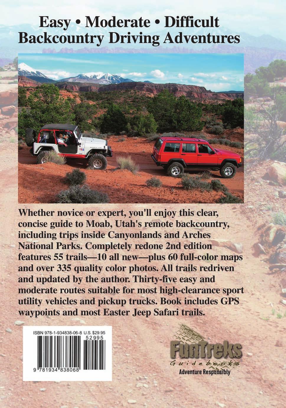
 Published by FunTreks, Inc. P.O. Box 3127, Monument, CO 80132-3127 Phone: Toll free 877-222-7623 Fax: (719) 277-7411 E-mail: books@funtreks.com Web site: www.funtreks.com Copyright 2011 by FunTreks, Inc.
Hiking Las Vegas.com
 Hike: Juniper Peak up and back Trailhead: Oak Creek Canyon marked Distance: 5.5 miles round trip Elevation gain: 2,200 feet Elevation peak: 6,109 feet Time: 4 to 5 hours - Up and back Difficulty: 3 Danger
Hiking Las Vegas.com
 Hike: Mt. Wilson via First Creek Canyon route Trailhead: First Creek marked Distance: 10 miles up and back Elevation gain: 3,400 feet Elevation of Peak: 7,070 feet Time: 7 to 9 hours (up and back) Difficulty:
Skiing and Snowshoes on Un-groomed Fernan Saddle Terrain
 Skiing and Snowshoes on Un-groomed Fernan Saddle Terrain Three ski or snowshoe routes are available from the Fernan Saddle Parking Lot which either do not cover routes ordinarily groomed for snow machine
Tiger Mountain State Forest:
 98 60 hikes within 60 miles: SEATTLE 20 Tiger Mountain State Forest: West Tiger Mountain Three Loop i KEY AT-A-GLANCE INFORMATION Length: 5.1 miles round-trip Configuration: Loop Difficulty: Moderate difficult
UTAH S NATIONAL PARK TOUR
 UTAH S NATIONAL PARK TOUR DAY 1 Each client needs to check in any time at the fabulous Aria Hotel located in the heart of Las Vegas. We will meet at 6pm for a one hour orientation explaining the schedule
Southern Utah University Hike Brochure
 Southern Utah University Hike Brochure Taylor Creek Trail Twenty minutes from Cedar City Red Hollow An hour and a half from Cedar City Fees: Entrance fee to Kolb Canyon Length: 5 miles round trip Length:
GOLDEN EARS PROVINCIAL PARK
 GOLDEN EARS PROVINCIAL PARK Trail Information as of October 10 th 2015 Do not underestimate the mountainous wilderness of Golden Ears Provincial Park. The combination of rugged terrain and rapidly changing
Section 7: Pick Up Where You Left Off! S-Tree Road over the Todd Road
 2018 TRACE NOTES Helpful information for your adventure on Section 7 of the Hiker Challenge. Start Point S-Tree Rd. End Point Intersection Todd Rd. / Hale Ridge Rd. WEATHER DECISION Weather Alert!!!! Potential
Hiking Trail Descriptions
 Hiking Trail Descriptions For ye shall go out with joy. And be led forth with peace. The mountains and the hills shall break forth before you in singing. And all the trees of the fields shall clap their
LOWER SPRING CANYON - CAPITOL REEF
 LOWER SPRING CANYON - CAPITOL REEF Rating: Moderate Hike Length: 5-7 hours (10-11 miles) Gear: Standard Hiking Gear Maps: Fruita, UT; Twin Rocks, UT; Water: A filterable spring a bit over 1/2 way. Recommend
A DESERT CAMPING GUIDE FOR ANZA BORREGO DESERT STATE PARK
 A DESERT CAMPING GUIDE FOR ANZA BORREGO DESERT STATE PARK With over 500,000 acres of beautiful terrain, Anza Borrego Desert State Park offers endless opportunities for Boy Scout Troops, Venture Crews and
Drive and Stop Routes
 Drive and Stop Routes Limantour Road 1 - easy and likely productive. From Bear Valley Visitor Center drive back out and turn left onto Bear Valley Rd. Turn left at Limantour Road (the first road). Drive
Non-motorized Trail Plan & Proposal. August 8, 2014
 Town of Star Valley Ranch, Wyoming and the Star Valley Ranch Association in partnership with the USDA Forest Service, Bridger-Teton National Forest, Greys River Ranger District Non-motorized Trail Plan
A Publication of Friends of Sleeping Bear Dunes
 A Publication of Friends of Sleeping Bear Dunes 2014, Friends of Sleeping Bear Dunes, P.O. Box 545, Empire, MI 49630 www.friendsofsleepingbear.org info@friendsofsleepingbear.org Learn more about the Friends
San Juan Hut Systems Durango to Moab Route Description
 San Juan Hut Systems Durango to Moab Route Description Adventure Without The Weight Using the Daily Route Description: Due to varying calibrations in odometer, riders may notice some inaccuracies in the
THE NATIONAL PARKS V 8 TOUR
 THE NATIONAL PARKS V 8 TOUR This National Tour will visit the spectacular red rocks and canyon country of Western Colorado and Eastern Utah, with a few high mountains thrown in for additional flavor. The
(west) onto Charleston Boulevard. Drive 16 miles on Charleston and turn right into Red Rock
 onto Charleston Boulevard. Drive 16 miles on Charleston and turn right into Red Rock") Hike: North Peak and Ice Box Overlook up and back Trailhead: 2.5 miles up the Rocky Gap Road not mark Distance: 5 miles round trip Elevation gain: 2,694 feet Elevation Peak: 7,094 feet Time: 3 to 5 hours
Hike: North Peak and Ice Box Overlook up and back Trailhead: 2.5 miles up the Rocky Gap Road not mark Distance: 5 miles round trip Elevation gain: 2,694 feet Elevation Peak: 7,094 feet Time: 3 to 5 hours
DESERT SOLITAIRE. Pinnaclemag.com
 DESERT SOLITAIRE Inconvenient and remote, Moab, Utah is an oft-overlooked gem for true wilderness enthusiasts. Despite its renowned Slickrock Trail and its close proximity to two national parks, Moab remains
beach. Make the ford and follow the trail out to the junction with Red Creek Tr in an open grassy area.
 Description: This is a moderate to slightly strenuous 22.8 mile backpack (add 2.6 miles if you do the packless out and back to the Lion s Head) that will have you exploring nearly every thing that is The
The temperature is nice at this time of year, but water is already starting to be scarce.
 In March of 2003, Scott Morrison and I went backpacking in the Grand Canyon. The temperature is nice at this time of year, but water is already starting to be scarce. Another issue with this time of year
Internet TripTik. From : Zion National Park, Ut Stop At Stop At Stop At Stop At Stop At. : Bryce Canyon National Park, Ut : Arches National Park, Ut
 MAP: Overview Internet TripTik From : Zion National Stop At Stop At Stop At Stop At Stop At To : Bryce Canyon National Park, Ut : Arches National : Canyonlands National : Monument Valley, Utah : Kayenta,
San Luis Obispo. Bishop Peak Felsman Loop Eagle Rock Maino Open Space Poly Canyon Poly P Other Areas
 San Luis Obispo Bishop Peak Felsman Loop Eagle Rock Maino Open Space Poly Canyon Poly P Other Areas 1 JCT. ELEV. 72 400 00 0 FELSMAN LOOP GATE LOOP RIDGE 600 FENCE JCT. ELEV. 860 1000 1200 BISHOP PEAK
CAMELBACK MOUNTAIN: CHOLLA TRAIL
 CITY OF PHOENIX :: Camelback Mountain: Cholla T rail 21 CAMELBACK MOUNTAIN: CHOLLA TRAIL IN BRIEF Camelback Mountain is the tallest point in the city of Phoenix. From the 2,704-foot summit of Camelback,
Berowra Waters to Cowan Station
 Berowra Waters to Cowan Station 3 hrs 30 mins 7.2 km One way Hard track 597m This is a hilly walk out of the beautiful Berowra Waters valley to Cowan Station. There are many wide views across Berowra Creek
Central Overland Trail Utah & Nevada Driving Guide, First Edition, 2016
 Central Overland Trail Utah & Nevada Driving Guide, First Edition, 2016 Page 51 In the third paragraph, second sentence, change 0.4 miles to 0.1 miles. In the fourth paragraph, second sentence, change
Route #2) Mt. Massive - Southwest Slopes
 Mt. Massive - Southwest Slopes") Route #2) Mt. Massive - Southwest Slopes Difficulty: Class 2 Ski: Advanced, D6 / R2 / III Exposure: Summit Elevation: Trailhead Elevation: Elevation Gain: Round-trip Length: Trailhead: County Sheriff:
Route #2) Mt. Massive - Southwest Slopes Difficulty: Class 2 Ski: Advanced, D6 / R2 / III Exposure: Summit Elevation: Trailhead Elevation: Elevation Gain: Round-trip Length: Trailhead: County Sheriff:
Mt. Sneffels (from Yankee Boy Basin) - A Cool Fourteener
 - A Cool Fourteener") Mt. Sneffels (from Yankee Boy Basin) - A Cool Fourteener Difficulty: Difficult Class 3 Exposure: Summit Elev.: 14,150 feet Trailhead: Yankee Boy Basin Climbers: Rick Crandall; Shan Stuart; Laura Welch
Mt. Sneffels (from Yankee Boy Basin) - A Cool Fourteener Difficulty: Difficult Class 3 Exposure: Summit Elev.: 14,150 feet Trailhead: Yankee Boy Basin Climbers: Rick Crandall; Shan Stuart; Laura Welch
Crystal Lake Area Trails
 Lake Area Trails Welcome to the Lake area of the Big Snowy Mountains! This island mountain range in central Montana features peaks reaching to 8,600 feet and long, high ridges from which vistas of the
Trail Beginning Elevation: 7553 ft The Poison Creek Trailhead is located at the end of National Forest Road 646E (NF-646E).
.") West Mountain Trails Poison Creek Trail #134 Length: 2.9 miles (4.7 km) Difficulty Horseback: A good trail for the first time west mountain rider, some steep sections Hiking: Most Difficult USGS Maps:
West Mountain Trails Poison Creek Trail #134 Length: 2.9 miles (4.7 km) Difficulty Horseback: A good trail for the first time west mountain rider, some steep sections Hiking: Most Difficult USGS Maps:
INTERMEDIATE. mayorsmtbchallenge.org
 mayorsmtbchallenge.org Redding s second local Mountain Bike Challenge uniting current and new bicyclists in a friendly self-competition highlighting our diverse trail system. INTERMEDIATE Mule Ridge Cosmos
Lava Mountain Trail Distance: Elevation Range: Trail Type: Difficulty: Season: Driving Distance: Driving Time: USGS Maps: Pros Cons
 Lava Mountain Trail Distance: 13.4 miles (including the side trip to North Star Lake) Elevation Range: 5900'-8330' Trail Type: singletrack Difficulty: moderate Season: late June-October Driving Distance:
Dreamscapes of the American Southwest. Las Vegas to Salt Lake City
 Dreamscapes of the American Southwest Las Vegas to Salt Lake City Day 1: Grand Canyon National Park and Lake Powell Premium Lodging: Lake Powell Resort: Page, AZ Departing from Las Vegas, our journey will
ASRA 2018 Hike Schedule
 ASRA 2018 Hike Schedule Date/Day Destination Hike Info Meeting Info Leader Feb 10, Saturday Stagecoach and 9:00 at the Confluence kiosk. Manzanita trails Parking fee required. We ll hike along the trail
Vision for national parks highway has Grand County hole
 Vision for national parks highway has Grand County hole BY LEE DAVIDSON THE SALT LAKE TRIBUNE PUBLISHED: DECEMBER 15, 2014 10:37AM UPDATED: DECEMBER 15, 2014 11:20AM For fellow legislators touring the
ATACAMA CROSSING 2008 COURSE HANDBOOK STAGE 1. CP1 CP2 CP3 CP4 camp 2 Total Difficult Moderate Moderate km km 8.38 miles. 7.
 Camp 1: Rock Carvings Camp 2: Inca (On the edge of the slot canyons) 1: Navigation by Rock Altitude, rolling hills, flat out landscape. CP2 and Piedra de los cocas hieroglyphs Inca influence - side of
GUIDED HIKING. *Guests need to bring seasonally appropriate layers, hat, sun glasses, water bottle and sunscreen. Cancellation Policy
 GUIDED HIKING Hiking around Dunton into the beautiful San Juan Mountains is the quintessential wilderness experience. Trails lead you through exquisite high alpine basins blanketed in wildflowers amidst
BRYCE CANYON COUNTRY Boulder Mountain Scenic backways itinerary
 BRYCE CANYON COUNTRY Boulder Mountain Scenic backways itinerary Boulder Mountain Area The high plateaus of the Aquarius Plateau (Boulder Mountain), are heavily forested and covered in countless winding
Colorado s forests are slated to lose thousands of miles of roads through the new OHV Route Designation process. DON T LET IT HAPPEN!
 Colorado s forests are slated to lose thousands of miles of roads through the new OHV Route Designation process. DON T LET IT HAPPEN! This packet identifies many roads that you may lose if you don t act.
RED ROCK / SYCAMORE CANYON LOOP
 SCEIC DRIVES TO/OM SEDOA RED ROCK / SYCAMORE CAYO This drive takes you into the heart of Sedona s magnificent Red Rock Country. The route hugs to the foot of those colorful cliffs, and offers the option
GUIDED HIKING. Cancellation Policy. Cancellations within 72 hours of the scheduled activity will result in full payment
 GUIDED HIKING Hiking around Dunton and the beautiful San Juan Mountains, is the quintessential wilderness experience. You ll walk through exquisite high alpine basins blanketed in wildflowers amidst high
100 Mountain & Desert Trails
 100 Mountain & Desert Trails GUIDE TO California Backroads & 4-Wheel-Drive Trails EASY MODERATE DIFFICULT Charles A.Wells & Matt eterson ublished by FunTreks, Inc..O. Box 3127, Monument, CO 80132-3127
BULLET CANYON - GRAND GULCH
 BULLET CANYON - GRAND GULCH Rating: Long Dayhike / Easy Backpack Length: 7-10 hours Gear: Standard Hiking Gear Maps: Cedar Mesa North, UT; Pollys Pasture, UT Water: Several Spring in Bullet and at the
20-Day Southwest American Adventure
 20-Day Southwest American Adventure The Southwest region of the United States is one that captivates so many adventurers hearts. Can you imagine yourself a homesteader crossing this vast land and coming
Beaver Country Trails ATV Jamboree
 Beaver Country Trails ATV Jamboree #1 Lincoln Mine Intermediate (Open to all ATVs/UTVs) 34 Miles Highlights: This ride will highlight the historic Lincoln Mining District, the first lead mine in Utah,
Bryce Canyon Country.
 Bryce Canyon Country Backways Itinerary - Grand Staircase, Capitol Reef Region Grand Staircase/Capitol Reef/Henry Mountains Adventure off the beaten path and revel in the beauty of Utah s scenic backways.
Other Agencies and Organizations
 Daniel Boone National Forest 1700 Bypass Road WInchester, KY 40391 859-745-3100 Location Northern terminus is near Morehead, Kentucky. Southern terminus is located in the Big South Fork NRRA in Tennessee.
Best of the Southwest - National Geographic Sweepstakes
 SAMPLE ITINERARY Friday June 15th, 2018 - Friday June 22nd, 2018 Best of the Southwest - National Geographic Sweepstakes Program Meals Friday June 15th Saturday June 16th Sunday June 17th Day 1: Arrive
MOUNTAIN BIKING THE CASCADE LOOP
 MOUNTAIN BIKING THE CASCADE LOOP By Henry Freimuth All photographs by Henry Freimuth The Cascades are on the Spanish Creek, which is a tributary of the Feather River. The Feather River was named by Spanish
Canyons of South-Western USA
 Canyons of South-Western USA The canyon is calling and I must follow... 30 April to 19 May 2018 29 April to 18 May 2019 Trip Length: 20 days / nights Minimum 6 guests / Maximum 11 guests (Maximum numbers
HORSEBACK RIDING. All rates are subject to service charges
 HORSEBACK RIDING The Local Loop Ride - A family-friendly 45-minutes to one hour ride around Dunton s east property. Perfect for children and adults who are new to riding. Easy terrain and beautiful views.
Utah Canyon Country Arches and Canyonlands National Parks March 25-31, 2012
 Utah Canyon Country Arches and Canyonlands National Parks March 25-31, 2012 We took advantage of the last week of our national parks pass and headed to the Moab area and visited my parents and family for
Mt Kuring-gai Track to Berowra station
 Mt Kuring-gai Track to Berowra station 4 hrs 15 mins 9.7 km One way Hard track 4 553m This walk explores three valleys, with great displays of wild flowers in spring, and some nice sandstone overhangs.
Bryce Canyon Country ATV Multi-Day Itinerary
 Bryce Canyon Country ATV Multi-Day Itinerary Look for more trail information and maps on these web-sites listed below. www. Casto Canyon Kick off your ATV adventure with this 36 mile round-trip ride through
Staples Lookout to Mt Wondabyne loop
 Staples Lookout to Mt Wondabyne loop 4 hrs 3 mins 1.8 km Circuit Hard track 337m This walk starts and finishes at Staples Lookout, on Woy Woy Rd. The walk follows sections of the Great North Walk around
YOSEMITE ON HORSEBACK: THREE RIDES ALONG TIOGA ROAD Cindy Casey White Wolf Area, May Lake Loop, Ragged Peak Loop
 YOSEMITE ON HORSEBACK: THREE RIDES ALONG TIOGA ROAD Cindy Casey White Wolf Area, May Lake Loop, Ragged Peak Loop The high country along Tioga Road presents us with some of the most dramatic scenery in
HIKING/BIKING IN MERRITT AREA
 HIKING/BIKING IN MERRITT AREA Coquihalla Lakes: Just inside the southern boundary of BC Park's Coquihalla Summit Park, a nice little twin lakes paddle with a private campground & lodge is the Coquihalla
NATIONAL ATV / UTV JAMBOREE RIDES
 NATIONAL ATV / UTV JAMBOREE RIDES Note: Rides range from Beginner to Advanced and will last from 2 to 3 hours or an entire day of riding. 1. DESERT RIDE (CLEAR LAKE BIRD REFUGE & LACE CURTAINS/LAVA TUBES)
Zion National Park/Gooseberry Weekend
 WATCH THE VIDEO Zion National Park/Gooseberry Weekend LENGTH: 3 Days / 2 Nights ACCOMMODATIONS: Camping FITNESS LEVEL: Intermediate For up-to-date pricing and dates, please visit our website. This fun-filled
Route Combo) Mt. Bierstadt - Bierstadt, Sawtooth, Evans
 Mt. Bierstadt - Bierstadt, Sawtooth, Evans") Climbing 14ers can be very dangerous, please read the Mountaineering Safety Page and make sure you have a map+compass and can use them effectively, without the help of electronic devices. Route Combo)
Climbing 14ers can be very dangerous, please read the Mountaineering Safety Page and make sure you have a map+compass and can use them effectively, without the help of electronic devices. Route Combo)
Cherokee Hiking Club Trail Blurb
 Cherokee National Forest Trail #164 Distance: 6.2 miles Elevation Change: 2280 feet High Point: 3692 feet (Waucheesi Mountain) Low Point: 1412 feet (Wildcat Creek) Trail Rating: Moderately Strenuous (NW
Beaver Creek State Park
 GENERAL INFORMATION Name of Park/Forest/Facility: Beaver Creek State Park County: Columbiana (St. Clair Township) Address: 12816 Sprucevale Road (ie County Rd 428) (street #, city) East Liverpool, Ohio
Note: Coordinates are provided as Universal Transverse Mercator UTM Zone U21, North American Datum 1983 (NAD 83).
.") Northern Traverse Route Description The Northern Traverse (formerly the North Rim Traverse) is an unmarked and rugged backcountry hiking route. It is known be a demanding hike, because of its terrain and
Northern Traverse Route Description The Northern Traverse (formerly the North Rim Traverse) is an unmarked and rugged backcountry hiking route. It is known be a demanding hike, because of its terrain and
Stephens State Park Trails
 TRAILS OF ALLAMUCHY MOUNTAIN & STEPHENS STATE PARKS Allamuchy Mountain and Stephens State Parks contain 28 marked trails providing access to diverse landscapes for walking, hiking, biking, bird-watching,
Trail Assessment Report
 Trail Assessment Report Trail Options for the Bear Creek Canyon located in Pikes Peak Ranger District, Pike National Forest and on Colorado Springs Utility Lands Due to the presence of a unique species
Little Grand Canyon near Pomona, Illinois
 Little Grand Canyon near Pomona, Illinois Below: View of the trail and the terrain created using the Map My Hike app Below: Summary of the hike created using the Map My Hike app Presented by: Jennifer
NATIONAL ATV / UTV JAMBOREE RIDES
 NATIONAL ATV / UTV JAMBOREE RIDES Note: Rides range from Beginner to Advanced and will last from 2 to 3 hours or an entire day of riding. 1. DESERT RIDE (CLEAR LAKE BIRD REFUGE & LACE CURTAINS/LAVA TUBES)
Erskine Creek via Pisgah Rock and Jack Evans
 Erskine Creek via Pisgah Rock and Jack Evans 4 hrs 30 mins 7.1 km Circuit Very experienced only 6 421m This walk visits some great lookouts and explores the lower section of Erskine Creek. Most of the
COURSE DESCRIPTION AND DIRECTIONS
 COURSE DESCRIPTION AND DIRECTIONS START TO BOUNTIFUL B (MILE 0 to MILE 17.05) From the start at East Mountain Wilderness Park, go past the green metal gate of East Mountain Wilderness Park and follow the
BRYCE CANYON COUNTRY. A twisted tree endures rugged life on the rim of the Paunsaugunt Plateau.
 BRYCE CANYON COUNTRY Grand Staircase - Paunsaugunt Plateau Scenic backways itinerary A twisted tree endures rugged life on the rim of the Paunsaugunt Plateau. Travel to Bryce Canyon Country. Lodging check-in,
Leaden Boot Challenge ROUTE INSTRUCTIONS
 Leaden Boot Challenge ROUTE INSTRUCTIONS Section 1 Alstonefield to Ilam From the village hall car park turn R then L and pass through the village keeping to the R to enter Church Street. Pass the Church
TAKE YOUR TIME STAKEHOLDERS GUIDE
 TAKE YOUR TIME STAKEHOLDERS GUIDE 2015 Best Ad Campaign WINNER Our award-winning TAKE YOUR TIME ad campaign has brought incredible success to the community. The campaign features TV spots, print ads and
Manti-La Sal National Forest Mountain Bike Trails
 Manti-La Sal National Forest Mountain Bike Trails Trail Name Miles Kilometers Trail Difficulty Rating MTB Project Ranking System New Mexico National Abajo Loop 14.1 22.7 Difficult 2.5 1 127 3,167 Aspen
GIFFORD PINCHOT NATIONAL FOREST
 GIFFORD PINCHOT NATIONAL FOREST 9341 Wright Meadow 93 Spencer Meadow Spencer Butte 4247' 30 30A 19 24 80 31C Lewis River Lower Falls 5 Quartz Creek 90 Taidnapam Falls Upper Falls 31 Spencer Peak 3861'
DD FORM 3009, FEB 2016 REPLACES DA FORM 1247, WHICH IS OBSOLETE. Page 1 of 6 Pages Adobe Professional X
 ROUTE CLASSIFICATION For use of this form, see ATP 3-34.81/MCWP 3-17.4; the proponent agency is TRADOC. SECTION I 1. SERIAL NUMBER 2. TO 3. FOR INFORMATION 4. DATE/TIME GROUP 5. NUMBER OF SHEETS OR ENCLOSURES
Piestewa Peak/Dreamy Draw Trail Guide
 Piestewa Peak/Dreamy Draw Trail Guide Trail #1A - Perl Charles Memorial Trail Length: 4.8 miles Elevation: 2,200 ft. - 1,340 ft. Difficulty: Moderate to difficult The Perl Charles trailhead is located
Dreamscapes of the American Southwest Salt Lake City to Las Vegas
 Dreamscapes of the American Southwest Salt Lake City to Las Vegas Day 1: Arches National Park Premium Lodging: The Sorrel River Resort and Spa: Moab, UT We will depart from Salt Lake City at 10 AM for
playwinterpark.com Off The Beaten Path Hikes Hiking Recommendations for the Adventurous Hiker
 playwinterpark.com Off The Beaten Path Hikes Hiking Recommendations for the Adventurous Hiker Hike: Devil s Thumb (difficult) Length: 3.93 miles one-way Elevation: Trailhead 9609 Destination 12,236 Trailhead
FLY FISHING. Half Day $400 for one person -or- $275 per person for 2+ people Full Day $550 for one person -or- $350 per person for 2+ people
 FLY FISHING Enjoy classic western fly fishing on the West Fork of the Dolores River. Both the Dunton Hot Springs and Dunton River Camp offer anglers a combination of meadow oxbows and pocket water canyons.
Difficult Run Stream Valley Park
 Difficult Run Stream Valley Park The more intense mountain bikers have known about for Difficult Run for some time. Equestrians have known it longer. Eight miles of unpaved trail, the Rails to River Trail
Lake Wissota Access Locations within the LaFayette Township. By Chad Martin
 Lake Wissota Access Locations within the LaFayette Township By Chad Martin Anson/ Wissota Access Point # 1 Road: 195 th St. Associated Fire Numbers: 13294 Defining Characteristics: Forested from road
CIEC 9 PEAKS AWARD SUPPLEMENT POSSIBLE ROUTES FOR THE 9 PEAKS AWARD TRIP
 CIEC 9 PEAKS AWARD SUPPLEMENT POSSIBLE ROUTES FOR THE 9 PEAKS AWARD TRIP As you plan your trip, be aware of 3 regulations in this wilderness: 1. Camp only in designated campsites. 2. No campfires allowed.
Rogue Gorge (Mt. Stella) Roadless Area-- T30S R3E (primarily in portions of Sections 23, 26, 33, 34 & 35)
 Roadless Area-- T30S R3E (primarily in portions of Sections 23, 26, 33, 34 & 35)") Rogue Gorge (Mt. Stella) Roadless Area-- T30S R3E (primarily in portions of Sections 23, 26, 33, 34 & 35) Rogue River-Siskiyou National Forest--High Cascades Ranger District Upper, higher elevation trail
Rogue Gorge (Mt. Stella) Roadless Area-- T30S R3E (primarily in portions of Sections 23, 26, 33, 34 & 35) Rogue River-Siskiyou National Forest--High Cascades Ranger District Upper, higher elevation trail
Kirigalpoththa Nature Trail Horton Plains National Park
 Kirigalpoththa Nature Trail Horton Plains National Park Trail Difficulty: Easy Moderate Strenuous Tough Trail Head: Horton Plains Visitor Centre Nearest Town: Pattipola Nearest City: Nanu-Oya Access to
AOTA ArtTrek Locations
 AOTA ArtTrek Locations ArtTrek is a summer-long Grand County, CO art adventure. Highlighted by snow-covered mountain vistas and rolling meadows threaded with sparkling streams and rivers, numerous sites
C E N T R A L C A T S K I L L S
 120 C E N T R A L C A T S K I L L S Central Catskills Once out of the southern parts of the Catskills, the Long Path enters the more well traveled and civilized regions. The trail joins the Devil s Path,
ELEPHANT BUTTE LAND 640 Acres of pristine land surrounded by BLM property Next to Coral Pink Sand Dune Area Southern Utah INVESTMENT OFFERING
 640 Acres of pristine land surrounded by BLM property Next to Coral Pink Sand Dune Area Southern Utah PROPERTY DESCRIPTION Nestled within one of Southern Utah s picturesque red cliff valleys, with spectacular
Moab South (National Geographic Trails Illustrated Map) By National Geographic Maps - Trails Illustrated READ ONLINE
 By National Geographic Maps - Trails Illustrated READ ONLINE") Moab South (National Geographic Trails Illustrated Map) By National Geographic Maps - Trails Illustrated READ ONLINE If searching for a ebook by National Geographic Maps - Trails Illustrated Moab South
Moab South (National Geographic Trails Illustrated Map) By National Geographic Maps - Trails Illustrated READ ONLINE If searching for a ebook by National Geographic Maps - Trails Illustrated Moab South
PRIEST LAKE TRAILS. More information contact: Priest Lake Ranger District
 PRIEST LAKE TRAILS The varying terrain in the Priest Lake area ranges from river bottoms with an elevation of 2,600 to 7,500 ft. Valley bottoms, dense forests, meadows and occasional clearings and barren
Logan Canyon Hiking Trail Guide
 C a c h e V a l l e y V i s i t o r s B u r e a u Logan Canyon Hiking Trail Guide Monique Beeley Legend Trail Location Guide WASATCH CACHE NATIONAL FOREST WILDERNESS PAVED WATER TRAILHEAD 9 Logan River
Bradshaw Trails Series
 Bradshaw Trails Series Curtis James Troop 7014 Curtis.James@erau.edu My Motto: Never get lost! Hiking Rules Bradshaw Hiking Patch Series Hiking Tools Hiking Rules Hiking Merit Badge* Take five 10-mile