Disaster Evacuation Safe Zones in Clackamas County, Oregon Analysis: Two Scenarios
|
|
|
- Damian Barrett
- 6 years ago
- Views:
Transcription

1 Disaster Evacuation Safe Zone Analysis for Clackamas County, Oregon Part One: Caroline Rouwalk Part Two: Kathy Jepson June 3, Disaster Evacuation Safe Zones in Clackamas County, Oregon Analysis: Two Scenarios Part One: Mount Hood Eruption Scenario Part Two: Clackamas County Wildfire Scenario Goal: To determine safe areas to locate potential disaster evacuation centers 1
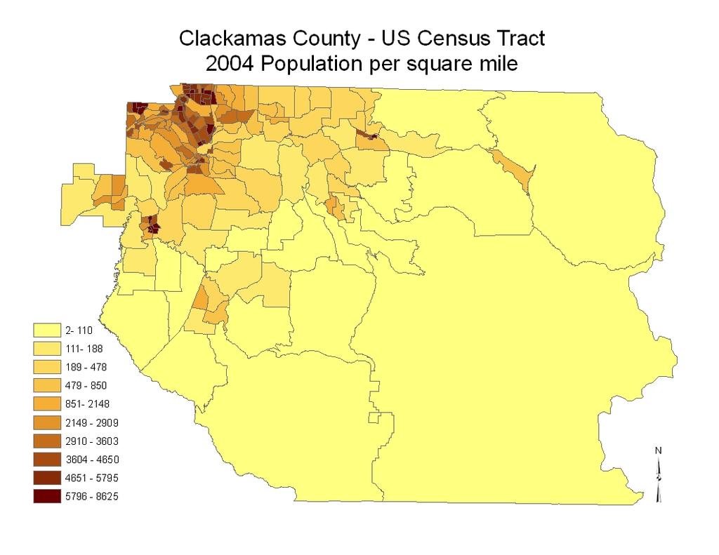
2 Mount Hood Eruption Safe Zones Goal Determine suitable safe areas for evacuation centers for communities affected by effects of Mount Hood eruption USGS recommends local agencies determine easily accessible gathering locations Why Determine Safe Zones? Mt Hood is the presents the highest volcanic hazard to Clackamas County. This volcano has been relatively quiet, with about 1 major event every 100 years. Risk to life, drinking water sources, essential infrastructure 2


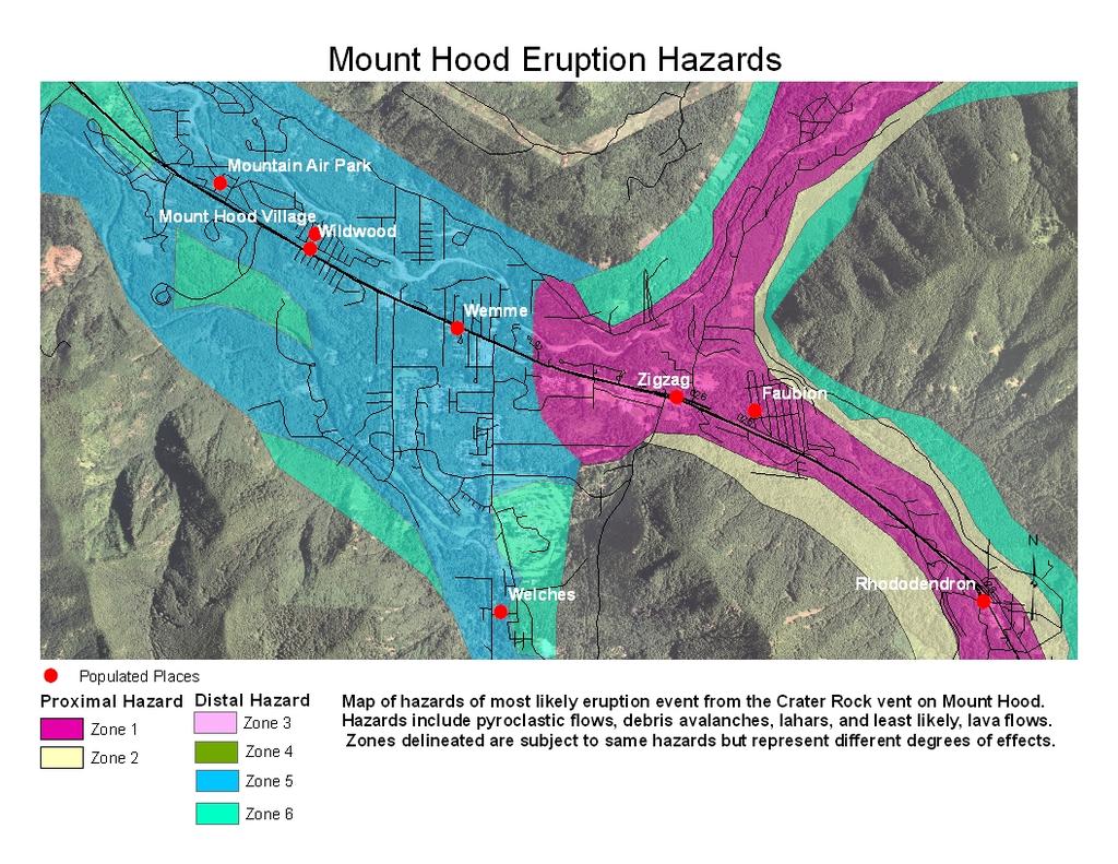
3 For this study hazards are: Pyroclastic flow Debris Landslide Lahar Lava flow Does not include ash fall projections Mount Hood 3

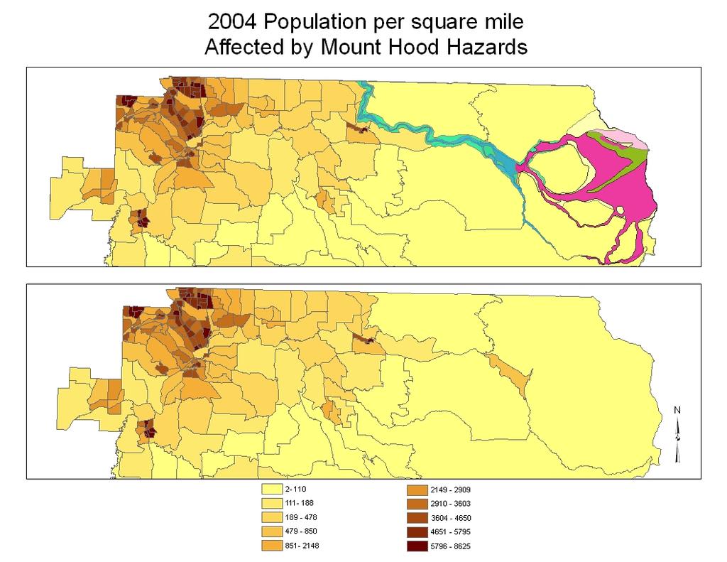
4 Step One: Gather Data Hazard map digitized from 2007 Clackamas County Mt. Hood hazard map based on USGS Mt. Hood hazard report in 2000 Clackamas county schools and houses of worship created using IRS tax exempt records, geocoding, current update work for Geographic Names Information System Clackamas county DEM mosaiced together from Oregon N and Oregon NW DEM. 2:00 1:30 0:30 1:00 0:30 Travel time of hazard Hazards from most probably eruption at Crater Rock vent on Mt. Hood. Zone 1 and 2 extremely vulnerable to rapidly moving pyroclastic flows, debris avalanches, and less likely, lava flows within less than 30 minutes after eruption. Zones 5 represents lahar risk and zone 6 represents lahar risk in a larger eruption event. Source: Clackamas County GIS and USGS Cascade Volcano Observatory 4
5 5
6 6
7 Steps to Safe Zones Best areas for evacuation center Use existing Schools or Houses of worship In Best Areas for Evacuation Centers Raster Calculator Weight and combine Reclassified datasets Spatial Analyst Reclassify Distance Spatial Analyst Reclassify Distance from Highways Spatial Analyst Euclidean Distance from Primary Hazard Spatial Analyst Euclidean Distance from Highways Determine areas at greatest risk Accessible by Open Highway Steps to suitable areas for evacuation map Alder CreekBrightwood Wildwood Wemme Zigzag Welches Faubion Rhododendron 173 Government Camp Alder CreekBrightwood Wildwood Wemme WelchesZigzag Faubion Rhododendron Governme 053 Euclidean Distance from highway Euclidean Distance from populated places in hazard zones Reclassify distance from highway Reclassify distance from populated places in hazard zone 7
8 Steps to suitable areas for evacuation map Raster Calculator: weight and combine Distance from hazard and Distance from Highway datasets 8

9 Conclusion Final output: 301 possible evacuation centers Recommend further site analysis include: 1. Transportation routes and accessibility 2. Evacuation center analysis to determine ability to handle evacuees 3. Ash fall projections 9
10 References Clackamas NHMP 2007 Update, Section 12, 63-69, 69, Hazard layer digitized from Clackamas County Mount Hood Hazards Map, Clackamas County GIS, Jim Lugosi, May 29, 2007 Clackamas school, houses of worship, and populated places data, USGS, -Geographic Names Information System, Available at Clackamas Digital Elevation Model 10 meter, mosaic from Oregon N and NW DEM downloaded from home.oit.pdx.edu/resources/students/data/gis/oregon/dem/ ½ meter ortho imagery, usgs Clackamas county boundary, Bureau of Land Management, available at Roads data and census data, Street Map Pro USGS Volcano Hazards Program, available at Disaster Evacuation Safe Zone Analysis for Clackamas County, Oregon Part 2: Wildfires By Kathy Jepson 10


11 Principals of Wildfire Behavior Topographic Influences Aspect Slope Elevation Fuel Weather Wind Exposure to Sunlight Fuels Aspect 11

12 Aspect Slope Steeper slopes burn faster. > > 40% slopes provide for rapid rates of fire movement. 12

13 Slope Elevation Air Fuel 13

14 Elevation Fuel Grass Grass Shrub Shrub Timber Litter Timber Slash 14


15 Grass Combination of Grass and Grass-Shrub Shrub Combination of Shrub and Timber Litter 15


16 Timber Combination of Timber and Slash Fuel 16
17 Combined Risk = (Aspect*weight)+(Slope*weight)+(Fuel*weight)+(Elevation*weight) Checking Weight 17
18 Weight Models Model# 1 AHP 2 AHP 3 equal Fuel Elevation Slope Aspect Results out of 88 (low) (mod) (high) Model# Fuel Elevation Slope Aspect Results out of 88 (low) (mod) (high) Good Model Model #8: (15%) (42%) (43%) 18


19 Weather Foehn Winds Wind 19
20 Safe Locations (Out of 350 possible schools and houses of worship) Questions? References: Geo Spatial Data Library. Introduction to Wildland Fire Behavior. National Wildfire Coordinating Group Oregon Department of Forestry Molalla Unit. Fire History Data Paul, Chris. Protection Supervisor. Oregon Department of Forestry Molalla Unit. RLIS. November 2007 USGS Geographic Names Information System. Clackamas Schools and Houses of Worship data Wikipedia. Foehn Winds Information. 20
A GIS Analysis of Probable High Recreation Use Areas in Three Sisters Wilderness Deschutes and Willamette National Forests
 Lindsey Kiesz Geo 565 Term Project 3/15/2010 A GIS Analysis of Probable High Recreation Use Areas in Three Sisters Wilderness Deschutes and Willamette National Forests Introduction The Three Sisters Wilderness
On Page 5, following the Planning Process subsection, insert the following: 2012 Committee members included:
 Appendix D: City of Happy Valley Addendum to the Clackamas County Natural Hazards Mitigation Plan 2012 Amendments and Update The Oregon Partnership for Disaster Resilience prepared this Appendix to the
DIGITAL TERRAIN AND VIEWSHED ANALYSIS CRATER LAKE NATIONAL PARK
 DIGITAL TERRAIN AND VIEWSHED ANALYSIS OF FINDING THE IDEAL CAMPSITE ALONG THE PACIFIC CREST TRAIL Source: Outdoor Travel Blog DON RYAN DIGITAL TERRAIN ANALYSIS GEOG 593 PROJECT OVERVIEW LOCATION HISTORY
Fire and Forestry in Oxbow Regional Park, GIS and GPS Implementation
 Fire and Forestry in Oxbow Regional Park, GIS and GPS Implementation Brian Handy, Karen Sexton, Robert Pierce GIS and GPS implementation at Oxbow Regional Park, Oregon, in the preparation for fire danger
Satisfying the Need: Finding Potential Campsite Locations in Farewell Canyon, B.C. Alexis Moore
 Satisfying the Need: Finding Potential Campsite Locations in Farewell Canyon, B.C. Alexis Moore 230075923 Geog 413 Final Project Write- Up Roger Wheate April. 13, 2012 Introduction & Purpose of Study The
A GIS Assessment of Erosion Vulnerability for Unofficial Trails in the Columbia River Gorge
 A GIS Assessment of Erosion Vulnerability for Unofficial Trails in the Columbia River Gorge Sachi Arakawa Geog 593 Digital Terrain Analysis Fall 2017 Abstract The city of North Bonneville, located along
GEOSPATIAL ANALYSIS OF GLACIAL HAZARDS PRONE AREAS OF SHIGAR AND SHAYOK BASINS OF PAKISTAN. By Syed Naseem Abbas Gilany
 GEOSPATIAL ANALYSIS OF GLACIAL HAZARDS PRONE AREAS OF SHIGAR AND SHAYOK BASINS OF PAKISTAN By Syed Naseem Abbas Gilany PRESENTATION OUTLINE Introduction Problem Statement / Rationale Objectives Material
Environmental Development of River Road Ranch
 Environmental Development of River Road Ranch New Braunfels, Texas Alix Scarborough GEO 3426 April 2012 Introduction The 2,400-acre Word-Borcher ranch has been owned by the Word family since 1941. Located
Ski / Sled tracks as an expression of avalanche risk Jordy Hendrikx 1 & Jerry Johnson 2,1 1.
 Ski / Sled tracks as an expression of avalanche risk Jordy Hendrikx 1 & Jerry Johnson 2,1 1 Snow and Avalanche Laboratory, Montana State University, Bozeman, Montana, USA 2 Political Science, Montana State
International Snow Science Workshop
 A PRACTICAL USE OF HISTORIC DATA TO MITIGATE WORKER EXPOSURE TO AVALANCHE HAZARD Jake Elkins Jackson Hole Mountain Resort, Teton Village, Wyoming Bob Comey* Jackson Hole Mountain Resort, Teton Village,
2018 SPRING MELT: FLOOD PREPAREDNESS
 018 SPRING MELT: FLOOD PREPAREDNESS A Regional District of East Kootenay Preparedness Guide Here in the East Kootenay the spring melt is underway. This seasonal preparedness bulletin will help provide
Barbara Ayers, Hood River County Emergency Manager
 Barbara Ayers, Hood River County Emergency Manager February, 2010 Chile 8.8 earthquake Haiti Earthquake 7.0 January 2010 Three million people were affected by the quake. Haitian Government estimated
Population Composition, Geographic Distribution, and Natural Hazards: Vulnerability in the Coastal Regions of Puerto Rico
 Population Composition, Geographic Distribution, and Natural Hazards: Vulnerability in the Coastal Regions of Puerto Rico Researchers Havidán Rodríguez, Ph.D. (DRC-UDel) Walter Díaz, Ph. D. (CISA-UPRM)
Meet the world s newest glacier at Mount St. Helens
 Meet the world s newest glacier at Mount St. Helens By Seattle Times, adapted by Newsela staff on 08.10.15 Word Count 733 Hikers walk past this chunk of the volcano that existed before May 18, 1980. The
Digital Terrain Analysis of Archer Mountain
 Digital Terrain Analysis of Archer Mountain Identifying a potential new recreational trail Photo: Justin Bush GEOG 593 - Duh Marcus Tobey Justin Bush Project Overview Background Project Area Overview Questions
Mt. Thielsen Trip Report: April 29, 2012
 Mt. Thielsen Trip Report: April 29, 2012 Outing Organizer: Geoff Hance, with Brent McGregor Elevation Gain: 3,800 feet, over warming snow, with an exposed summit block Distance: About 9 miles round trip
10.3. Community at Risk: Clackamas Fire District #1 Clackamas Fire District #1 (CFD#1) has been identified as a Community at Risk (CAR) by Oregon
 has been identified as a Community at Risk (CAR) by Oregon") 10.3. Community at Risk: Clackamas Fire District #1 Clackamas Fire District #1 (CFD#1) has been identified as a Community at Risk (CAR) by Oregon Department of Forestry. The District has participated in
10.3. Community at Risk: Clackamas Fire District #1 Clackamas Fire District #1 (CFD#1) has been identified as a Community at Risk (CAR) by Oregon Department of Forestry. The District has participated in
Robson Valley Avalanche Tract Mapping Project
 Robson Valley Avalanche Tract Mapping Project Prepared for: Chris Ritchie Ministry of Water Land and Air Protection 325 1011 4th Avenue Prince George, BC. V2L3H9 and Dale Seip Ministry of Forests 1011
Hotel Location Analysis using ArcGIS
 Hotel Location Analysis using ArcGIS Yang Yang Department of Geography University of Florida Outline Introduction Background Data Source Research Methodology Preliminary Result Introduction Location! Location!
Melinda McCoy, CDM Project Manager Jonathan Posner, CDM Steven Wolosoff, CDM Don Schroeder, CDM
 A Task 8-1 GIS List of Lands for BMPs for North Santa Monica Bay Regional Watershed Implementation Plan and Malibu Creek Watershed Bacteria TMDL Implementation Plan To: From: Carolina Hernandez, of Watershed
Wildland Fire Safety
 Wildland Fire Safety Prevent Fires Understand Wildfire Behavior Make a Plan Get to a Safety Zone Facility/Structure Protection: Maintain a defensible space of 100 around structures o Remove all flammable
WILDLAND FIRE EVACUATION PLAN
 WILDLAND FIRE EVACUATION PLAN Pre-Fire Preparation o Have adequate clearance around structures of all flammable material, a minimum 100 feet (including wood piles). Greater distances may be required based
Maps and satellite images of Ngorongoro Conservation Area (World Heritage Site)
") Maps and Satellite Images of Ngorongoro Conservation Area Above: Location of the Ngorongoro Conservation Area in East Africa (from: www.africannaturalheritage.org) Right: Ngorongoro Conservation Area lies
Maps and Satellite Images of Ngorongoro Conservation Area Above: Location of the Ngorongoro Conservation Area in East Africa (from: www.africannaturalheritage.org) Right: Ngorongoro Conservation Area lies
Presentation By. My duties and responsibilities in my country Collection and compilation of disaster related data from different Parts of the kingdom.
 Presentation By POKHAREL Lekh Nath Ministry of Home Affairs,His Majesty's Government of Nepal. Disaster Relief Section Kathmandu NEPAL Now as a visiting Researcher at ADRC. My duties and responsibilities
Year to Date Summary. Average and Median Sale Prices
 A Publication of RMLS, The Source for Real Estate Statistics in Your Community Residential Review: Metro Portland, Oregon December 2015 Reporting Period December Residential Highlights The Portland metro
MOUNT RINJANI VOLCANO TREKS
 2D 1N Crater Rim and Summit from Sembalun village This trek is suitable for beginner to experienced trekkers with good fitness. SCHEDULE Arrival day: Guests are picked up at their preferred location on
EO Contribution to Recovery Activities - A case study on the experience of the Great East Japan Earthquake -
 EO Contribution to Recovery Activities - A case study on the experience of the Great East Japan Earthquake - Michio Ito (Mr.) ito.michio@jaxa.jp Space Applications and Operation Center JAXA Purpose of
Executive Summary. Background of the issue
 Executive Summary Thousands of villagers in risk of losing their homes to a lake formed by a landslide which could burst its banks within days, the possible massive flood could affect more than 50,000
The Villages at Mt. Hood Pavement Quality
 Ü LITTLE SANDY RIVER LITTLER CLEAR CREEK 67 26 220 280 200 150 370 Barlow Trail Park SANDY RIVER MARMO T R D SANDY RIVER 1450 930 1700 SANDY RIVER LOLO PASS RD 1300 67 26 Wildwood Recreation Site 500 2800
2010 International Snow Science Workshop
 A GIS DATABASE FOR AVALANCHE FORECASTING IN COLORADO Douglas Scott 1* and Ethan Greene 2 1 Avalanche Mapping, Lafayette, Colorado, U.S.A. 2 Colorado Avalanche Information Center, Boulder, Colorado, U.S.A.
2010 International Snow Science Workshop
 USING GIS AND GOOGLE EARTH FOR THE CREATION OF THE GOING-TO-THE-SUN ROAD AVALANCHE ATLAS, GLACIER NATIONAL PARK, MONTANA, USA Erich H. Peitzsch 1*, Daniel B. Fagre 1, Mark Dundas 2 1 U.S. Geological Survey,
Ancient Cities: The History Of Pompeii By Charles River Editors
 Ancient Cities: The History Of Pompeii By Charles River Editors The City Of Pompeii Worksheets, Facts & Information For Kids - In Ancient Rome, Pompeii was a major resort city located in southern Italy
Understanding Travel Behaviour in Avalanche Terrain: A New Approach
 Understanding Travel Behaviour in Avalanche Terrain: A New Approach Jordy Hendrikx 1 * Jerry Johnson 2 and Ellie Southworth 1 1 Snow and Avalanche Laboratory, Department of Earth Sciences, Montana State
Japan Academic Network for Disaster Reduction (JANET-DR) and interdisciplinary collaboration. Science Council of Japan
 and interdisciplinary collaboration. Science Council of Japan") Japan Academic Network for Disaster Reduction (JANET-DR) and interdisciplinary collaboration Members of SCJ and 56 academic societies proceed JANET-DR which covers social sciences, life sciences, natural
Japan Academic Network for Disaster Reduction (JANET-DR) and interdisciplinary collaboration Members of SCJ and 56 academic societies proceed JANET-DR which covers social sciences, life sciences, natural
Watch Outs! Will Your Home Survive? The Homeowner s Watch Outs! will allow you to evaluate your situation and set a plan to correct any concerns.
 Homeowner s Watch Outs! Will Your Home Survive? The Homeowner s Watch Outs! will allow you to evaluate your situation and set a plan to correct any concerns. Each year, hundreds of homes are destroyed
Table of Contents List of Figures...3 List of Tables...4 Introduction...5 Geographic Overview...5 Emergency Response Analysis...
 D a m B r e a k A n a l y s i s o f E m m e t t, I d a h o F o r F e d e r a l E m e r g e n c y M a n a g e m e n t P l a n n i n g Prepared for: FEMA, Office of Response Planning (Professor Guth) Prepared
Investigation on Development of Agricultural Monitoring System Using Satellite Data
 Investigation on Development of Agricultural Monitoring System Using Satellite Data Genya SAITO (1), Daisuke KUNII (1), Naoki ISHITSUKA (2) (1) Tohoku University, 1-1,Tsutsumidori Amamiya-machi Aoba-ku,
THE DESIGN AND IMPLEMENTATION OF A PRACTICAL TSUNAMI EVACUATION DRILL
 THE DESIGN AND IMPLEMENTATION OF A PRACTICAL TSUNAMI EVACUATION DRILL K. TERUMOTO Wakayama University, Japan SUMMARY: Tsunami evacuation measures are now an urgent issue in Japanese coastal area. One of
MOUNT RINJANI VOLCANO TREKS
 3D 2N Crater Rim, Lake and Summit from Sembalun village This trek is suitable for beginner to experienced trekkers with good fitness. SCHEDULE Arrival day: Guests are picked up at their preferred location
Glacier change in the American West. The Mazama legacy of f glacier measurements
 Glacier change in the American West 1946 The Mazama legacy of f glacier measurements The relevance of Glaciers Hazards: Debris Flows Outburst Floods Vatnajokull, 1996 White River Glacier, Mt. Hood The
Oregon Region Report from the Oregon Mountain Rescue Council
 Oregon Region Report from the Oregon Mountain Rescue Council More current information can be found on each team s web site or at the Oregon Mountain Rescue Council s web site at http://corvallismountainrescue.org/omrc/
El Dorado County COMMUNITY WILDFIRE PROTECTION PLAN Community Tab for AUBURN LAKE TRAILS FIRE SAFE COUNCIL ACTIVITIES
 El Dorado County COMMUNITY WILDFIRE PROTECTION PLAN Community Tab for AUBURN LAKE TRAILS FIRE SAFE COUNCIL ACTIVITIES Prepared for Inclusion in the: EL DORADO COUNTY FIRE SAFE COUNCIL Community Wildfire
Economic Impact Analysis. Tourism on Tasmania s King Island
 Economic Impact Analysis Tourism on Tasmania s King Island i Economic Impact Analysis Tourism on Tasmania s King Island This project has been conducted by REMPLAN Project Team Matthew Nichol Principal
The Geological Pacific Northwest. Wednesday February 6, 2012 Pacific Northwest History Mr. Rice
 The Geological Pacific Northwest Wednesday February 6, 2012 Pacific Northwest History Mr. Rice 1 Free Response #2 Please do not simply list the items for this response. Full sentences!!! Minimum of 3-5
Fitch Mountain and FIRE!
 Fitch Mountain and FIRE! California s I-ZONE The I-ZONE is the Interface Between the Wildland and the Home. It is the area where wildland fuels threaten, or are threatened by, structural fuels. It includes
Community vulnerability in tropical coastal zones: tsunamis and cyclone storm surges. David King Centre for Disaster Studies James Cook University
 Community vulnerability in tropical coastal zones: tsunamis and cyclone storm surges David King Centre for Disaster Studies James Cook University Tsunami risk -- low probability. Storm surges -- high probability
The New Generation Fire Shelter
 A Publication of the National Wildfire Coordinating Group Sponsored by United States Department of Agriculture United States Department of the Interior National Association of State Foresters The New Generation
Lidar Imagery Reveals Maine's Land Surface in Unprecedented Detail
 Maine Geologic Facts and Localities December, 2011 Lidar Imagery Reveals Maine's Land Surface in Unprecedented Detail Text by Woodrow Thompson, Department of Agriculture, Conservation & Forestry 1 Introduction
Table Major analysis products provided by JAXA
 Report on JAXA s Response to the Great East Japan Earthquake - Assistance using earth observation satellites and communication satellites - 2.1.5 Product provision and utilization by users for disaster
Naples And Pompeii: Vesuvius, Herculaneum And The Amalfi Coast By Ezio Rendo
 Naples And Pompeii: Vesuvius, Herculaneum And The Amalfi Coast By Ezio Rendo If you are searched for the book Naples and Pompeii: Vesuvius, Herculaneum and the Amalfi Coast by Ezio Rendo in pdf format,
TEACHER PAGE Trial Version
 TEACHER PAGE Trial Version * After completion of the lesson, please take a moment to fill out the feedback form on our web site (https://www.cresis.ku.edu/education/k-12/online-data-portal)* Lesson Title:
Route #2) Mt. Massive - Southwest Slopes
 Mt. Massive - Southwest Slopes") Route #2) Mt. Massive - Southwest Slopes Difficulty: Class 2 Ski: Advanced, D6 / R2 / III Exposure: Summit Elevation: Trailhead Elevation: Elevation Gain: Round-trip Length: Trailhead: County Sheriff:
Route #2) Mt. Massive - Southwest Slopes Difficulty: Class 2 Ski: Advanced, D6 / R2 / III Exposure: Summit Elevation: Trailhead Elevation: Elevation Gain: Round-trip Length: Trailhead: County Sheriff:
MT. H O O D & T H E G O R G E T O U R I S M L I S T E N I N G S E S S I O N O V E R V I E W
 Oregon Tourism Listening Session Summary June 2018 T O U R I S M L I S T E N I N G S E S S I O N O V E R V I E W Travel Oregon, in partnership with the Mt. Hood Territory, hosted an Oregon Tourism Listening
Arizona National Scenic Trail
 1 The Arizona National Scenic Trail is an 800 mile recreation trail from Mexico to Utah that connects mountain ranges, canyons, deserts, forests, wilderness areas, historic sites, trail systems, points
UNITED AIRLINES LEONARD J. SALINAS FLIGHT DISPATCH 21APR2010
 UNITED AIRLINES LEONARD J. SALINAS FLIGHT DISPATCH 21APR2010 Congressional Hazards Caucus Alliance B747-400 B777 B767/B757/A320/A319 CODE OF FEDERAL REGULATIONS Sec. 121.535 Responsibility for operational
SHASTA WEST PLANNING AREA
 2016 SHASTA COUNTY COMMUNITY WILDFIRE PROTECTION PLAN SHASTA WEST PLANNING AREA Covering the communities of: Centerville Redding (west & downtown) Shasta I. PROPOSED PROJECTS A. THE PLANNING AREA SHASTA
along a transportation corridor in
 Rockfall hazard and risk assessment along a transportation corridor in the Nera Valley, Central Italy Presentation on the paper authored by F. Guzzetti and P. Reichenbach, 2004 Harikrishna Narasimhan Eidgenössische
OWEA Woolpert UAS Operations
 OWEA 2016 Woolpert UAS Operations UAS Rules and Regulations How Woolpert is Handling This The Exemption In December 2014 Woolpert received approval from the FAA regarding an exemption seeking relief from
Egnatia Odos Observatory. Egnatia Odos Observatory Monitoring of Egnatia Motorway s s Spatial Impacts
 Egnatia Odos Observatory Egnatia Odos Observatory Monitoring of Egnatia Motorway s s Spatial Impacts 1 Egnatia Odos Observatory 1. The unique Greek observatory of transport and spatial impacts 2. Scope
Platform and Products
 International Partnership Space Programme Earth Observation for the Preservation of Ecological Bacalar Corridor Platform and Products Terri Freemantle, Raffaella Guida, Paula Marti, Pasquale Iervolino
Chapter 14. The Physical Geography of Russia
 Chapter 14 The Physical Geography of Russia Chapter Objectives Identify the physical features and natural resources of Russia. Discuss the effects of Russia s climate and vegetation on life in the region.
Coordinated Population Forecast for Clackamas County, its Urban Growth Boundaries (UGB), and Area Outside UGBs
, and Area Outside UGBs") Coordinated Population Forecast for Clackamas County, its Urban Growth Boundaries (UGB), and Area Outside UGBs 2017-2067 Prepared by Population Research Center College of Urban and Public Affairs Portland
Coordinated Population Forecast for Clackamas County, its Urban Growth Boundaries (UGB), and Area Outside UGBs 2017-2067 Prepared by Population Research Center College of Urban and Public Affairs Portland
Why are Corridors Important? Corridors: a possible solution to habitat fragmentation. Carnivores and Habitat Fragmentation
 Identification of Potential Wildlife Corridors Utilized by the North American Badger (Taxidea taxus) in the San Francisco Bay Area & Monterey County Carnivores and Habitat Fragmentation Carnivores are
UAV Flight Services Company. What We Do. What Sets us Apart
 UAV Flight Services Company A dedicated team of aviators, technologists, and engineers. What We Do UAV flight services for data collection, mapping, and inspection What Sets us Apart Extensive field experience,
NORTH CASCADE SLACIER CLIMATE PROJECT Director: Dr. Mauri S. Pelto Department of Environmental Science Nichols College, Dudley MA 01571
 NORTH CASCADE SLACIER CLIMATE PROJECT Director: Dr. Mauri S. Pelto Department of Environmental Science Nichols College, Dudley MA 01571 INTRODUCTION The North Cascade Glacier-Climate Project was founded
Going-to-the-Sun Road, Glacier National Park, MT, USA Avalanche Path Atlas
 Going-to-the-Sun Road, Glacier National Park, MT, USA Avalanche Path Atlas Erich H. Peitzsch Daniel B. Fagre USGS Northern Rocky Mountain Science Center West Glacier, MT, USA Introduction... 2 Overview
Aviation Crisis Management in Europe
 2 nd International Conference on Cyber Crisis Cooperation and Exercises Athens, 23-24 September 2013 Aviation Crisis Management in Europe Cyber Attack Exercise CYBER 13 Žarko Sivčev Advisor to the Director
Multi Purpose Personal Safety System
 Multi Purpose Personal Safety System People deserve a Choice Survival Capsule LLC is comprised of Aerospace Engineers and a Doctor of Oceanography and Tsunami research (Former member of NOAA). Julian Sharpe
Preliminary Site Evaluation
 Preliminary Site Evaluation 100 Acre Site, US 72 Piperton, Tennessee Power Distributor: Chickasaw Electric Cooperative August 2010 SITE DATA SHEET PIPERTON US 72 SITE (100 ACRES): LOCATION & GENERAL DESCRIPTION
Land Figures & Spatial Data Infrastructure in KOSOVO
 Land Figures & Spatial Data Infrastructure in KOSOVO Idriz SHALA idriz.shala@gmail.com GIS -expert Afrim SHARKU afrim.sharku@gmail.com Land Management - Expert Kick-off meeting of the Regional Expert Advisory
Jill Hawk Chief Ranger, Mount Rainier National Park Tahoma Woods, Star Route Ashford, WA 98304
 January 21, 2003 Jill Hawk Chief Ranger, Mount Rainier National Park Tahoma Woods, Star Route Ashford, WA 98304 Re: Analysis of the Mount Rainier Climbing Program; Proposal to Increase Special Fee Dear
2.2 USER CENSUS DATA A site census estimated on 19/01/2016, together with Sky high 9 day census March 2014.
 2. LEVEL CROSSING USAGE 2.1 RAIL The train service over GREEN DRIFT level crossing consists of passenger and freight trains. There are 154 trains per day. The highest permissible line speed of trains is
Major Bushfires in Dandenong Ranges.
 Major Bushfires in Dandenong Ranges. The Dandenong Ranges is recognised as one of the most wildfire prone areas in the world, because of its mountainous topography, highly inflammable vegetation, aspect,
Volcanic Ash Exercise
 Volcanic Ash Exercise MET/ATM Seminar May 2017 Kazuki Ito Tokyo Volcanic Ash Advisory Center Japan Meteorological Agency Outline Volcanic Ash Exercise (VOLCEX) Background Objectives and Scope Tokyo VAAC
Summary of prescribed fires in Prince Albert National Park 2015
 Summary of prescribed fires in Prince Albert National Park 2015 Prince Albert National Park conducted four controlled fires in spring 2015, plus an additional fire in October. Fuel Management for Hazard
Visual and Sensory Aspect
 Updated All Wales LANDMAP Statistics 2017 Visual and Sensory Aspect Final Report for Natural Resources Wales February 2018 Tel: 029 2043 7841 Email: sw@whiteconsultants.co.uk Web: www.whiteconsultants.co.uk
Budi Hadi Narendra Harris Herman Siringoringo Chairil Anwar Siregar. Research and Development Center for Forest
 Budi Hadi Narendra Harris Herman Siringoringo Chairil Anwar Siregar Research and Development Center for Forest Background Coastal management should be wisely done as a part of watershed management. Typologically,
Outreach Notice. FREMONT-WINEMA NATIONAL FOREST Zone Planning Staff GS Winter Rim Zone Paisley and Silver Lake Ranger Districts
 Outreach Notice FREMONT-WINEMA NATIONAL FOREST Zone Planning Staff GS-0401-11 Winter Rim Zone Paisley and Silver Lake Ranger Districts The Position This position is located on the Winter Rim Zone, Fremont-Winema
WHENUAPAI AIRBASE IMPACTS OF CLOSURE ON CIVIL DEFENCE EMERGENCY MANAGEMENT IN THE AUCKLAND REGION
 WHENUAPAI AIRBASE IMPACTS OF CLOSURE ON CIVIL DEFENCE EMERGENCY MANAGEMENT IN THE AUCKLAND REGION INTRODUCTION The New Zealand Defence Force has made a decision to relocate military operations away from
USE OF 3D GIS IN ANALYSIS OF AIRSPACE OBSTRUCTIONS
 USE OF 3D GIS IN ANALYSIS OF AIRSPACE OBSTRUCTIONS A project by by Samuka D. W. F19/1461/2010 Supervisor; Dr D. N. Siriba 1 Background and Problem Statement The Airports in Kenya are the main link between
NivoTest : a personal assistant for avalanche risk assessment
 NivoTest : a personal assistant for avalanche risk assessment R.Bolognesi METEISK, CP 993, CH-1951 SION. www.meteorisk.com Introduction About avalanche risk Every mountaineer knows that avalanche hazard
Excelsior Pass Avalanche Accident January 1, 2008
 Excelsior Pass Avalanche Accident January 1, 2008 Accident Summary Time: 1 January 2008, approximately 13:00 hrs Location: Near Excelsior Pass to east of Church Mt, Northern Washington Cascades WA Activity:
One City's Wilderness: Portland's Forest Park By Marcy C. Houle READ ONLINE
 One City's Wilderness: Portland's Forest Park By Marcy C. Houle READ ONLINE Wedding Reservations Get ready to make your 2018 wedding reservation with Portland Parks & Recreation PP&R's Som Subedi named
Impact of the Mt. Baekdu explosion to South Korea s air transportation with Hypothetical scenario
 Impact of the Mt. Baekdu explosion to South Korea s air transportation with Hypothetical scenario Jiseon LEE, Ph.D. candidate, Dept. of Civil and Environmental Engineering, KAIST Yoonjin Yoon, Professor,
SOUTH INTERCHANGE AREA
 Santaquin City General Plan 1 Location and Characteristics The South Interchange Area of Santaquin is located west of Interstate 15 and south of 500 South (Figure 1). It includes properties already annexed
Household Preparedness Guide
 PreparedBC: Household Preparedness Guide A guide for protecting your family PreparedBC HOUSEHOLD PREPAREDNESS GUIDE Earthquakes, tsunamis, floods and wildfires are just some of the potential hazards in
Glacier Retreat/ Developement in Glacier National Park
 Geog 413 Term Project Glacier Retreat/ Developement in Glacier National Park Heather Miller December 01, 2004 Abstracts Introduction / background Data Source Data Manipulation Spatial analysis method/process
LAUNCHING YOUR UNMANNED AIRCRAFT PROGRAM
 LAUNCHING YOUR UNMANNED AIRCRAFT PROGRAM THE DARTDRONES TEAM UNMANNED AIRCRAFT APPLICATIONS AERIAL INSPECTIONS AERIAL INSPECTIONS Safer and faster alternative to visual inspection by an individual Damage
South Island Alpine Fault Earthquake Response Plan (SAFER) National Lifelines Conference Dr Caroline Orchiston, University of Otago
 National Lifelines Conference Dr Caroline Orchiston, University of Otago") South Island Alpine Fault Earthquake Response Plan (SAFER) National Lifelines Conference 2017 Programme Manager: Project Executive: Science Risk Lead: Jon Mitchell Angus McKay, EM Southland Dr Caroline
South Island Alpine Fault Earthquake Response Plan (SAFER) National Lifelines Conference 2017 Programme Manager: Project Executive: Science Risk Lead: Jon Mitchell Angus McKay, EM Southland Dr Caroline
2
 1 2 3 4 Why are pilots so focussed on safety? because: The pilots are always the first at an accident scene! 6 COUNCIL REGULATION (EEC) No 3922/91 Annex III, Subpart B 7 In addition to being the final
ENVIRONMENTAL HAZARDS OF AVALANCHES: PRELIMINARY RESEARCH IN GLACIER NATIONAL PARK
 ENVIRONMENTAL HAZARDS OF AVALANCHES: PRELIMINARY RESEARCH IN GLACIER NATIONAL PARK Site Focus: Balu Pass, Glacier National Park, B.C. Avalanche path near Balu Pass. (Photo Courtesy of: www.leelau.net/2007/rogerspass/day1/1)
Big Island Hawaii Explorer
 # 1933 Hawaii s Big Island is not only big in size, but also in diversity. There are snowy mountaintops, lush jungles, windswept grasslands, picturesque beaches, and lava fields - you can see all these
Mt. Hood [Map Pack Bundle] (National Geographic Trails Illustrated Map) By National Geographic Maps - Trails Illustrated READ ONLINE
![Mt. Hood [Map Pack Bundle] (National Geographic Trails Illustrated Map) By National Geographic Maps - Trails Illustrated READ ONLINE](/thumbs/85/92056945.jpg "Mt. Hood [Map Pack Bundle] (National Geographic Trails Illustrated Map) By National Geographic Maps - Trails Illustrated READ ONLINE") Mt. Hood [Map Pack Bundle] (National Geographic Trails Illustrated Map) By National Geographic Maps - Trails Illustrated READ ONLINE If you are looking for a book by National Geographic Maps - Trails Illustrated
Mt. Hood [Map Pack Bundle] (National Geographic Trails Illustrated Map) By National Geographic Maps - Trails Illustrated READ ONLINE If you are looking for a book by National Geographic Maps - Trails Illustrated
CHAPTER 9: REFERENCES AND INFORMATION SOURCES
 CHAPTER 9: REFERENCES AND INFORMATION SOURCES The following references and information sources are listed by resource in the order that the resources are addressed in this environmental assessment. General
Deer Canyon Preserve Ice and Fire
 Deer Canyon Preserve Ice and Fire Presented 10/20/18 by: Shelley Rossbach The Placitas Goup, Inc. Shelley0424@gmail.com Funded by Claunch-Pinto Soil & Water Conservation District Dee Tarr, Program Manager
1 INFORMATION REQUIREMENTS
 1 INFORMATION REQUIREMENTS 1.1 BACKGROUND 2 1.2 WHAT IS THE DISTRICT PLAN 3 1.3 DISTRICT PLAN STRUCTURE 4 1.4 HOW TO USE THE DISTRICT PLAN 5 1.5 STRATEGIC FRAMEWORK 6 Whanganui District Plan (15 January
Justification and Objective NRFA Standard Assessing Fire Hazards Key Requirements WTA and map If WTA 601 risk assessment following AS/NZS ISO Ri
 Strategic Tactical Fire Management Planning (STFMP) Multi-Agency Approach Presentation by Heather Wakelin Project led by the Department of Conservation Outline Justification and Objective Risk Assessment
TORONTO PEARSON INTERNATIONAL AIRPORT NOISE MANAGEMENT
 TORONTO PEARSON INTERNATIONAL AIRPORT NOISE MANAGEMENT Noise and the GTAA The GTAA is sensitive to the issue of aircraft noise and how it affects our neighbours. Since assuming responsibility for Toronto
Morning Star Peak Avalanche Accident
 Morning Star Peak Avalanche Accident Saturday, December 4, 2010 Date: 2010-12-13 Submitted by: Oyvind Henningsen Everett Mountain Rescue and Mark Moore NWAC Place: Morning Star Peak, north-central WA Cascades
Volcanoes produce large amounts of ash that
 GIS-Based Indices for Comparing Airline Flight-Path Vulnerability to Volcanoes Jeffrey A. VanLooy and Thomas J. Cova Center for Natural & Technological Hazards, University of Utah Volcanic ash can cause