CHAPTER 3.0 PROJECT DESCRIPTION
|
|
|
- Samson Fletcher
- 5 years ago
- Views:
Transcription
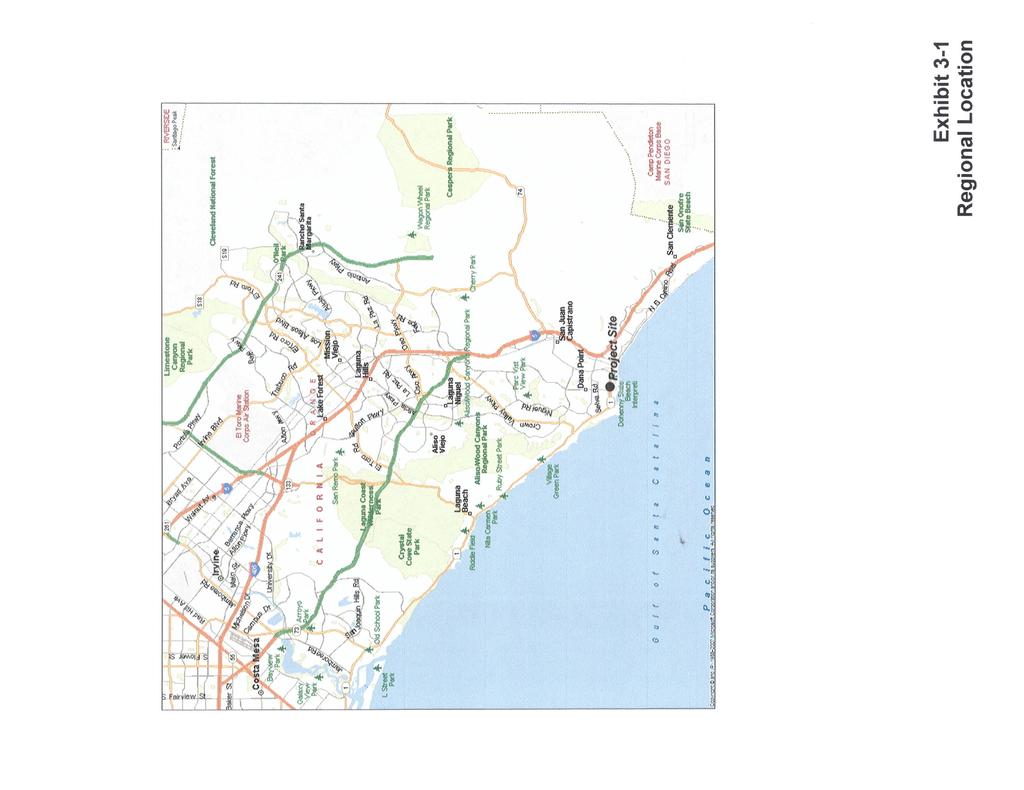
1 Pacific Coast Highway/Del Prado Avenue Phase I Street Improvement Project Chapter 3.0 Project Description CHAPTER 3.0 PROJECT DESCRIPTION 3.1 Project Location Regional Location The City of Dana Point is located in the southern portion of Orange County, approximately midway between San Diego to the south and Los Angeles to the north (refer to Exhibit 3-1). The community encompasses coastal bluffs and rolling hills located along seven miles of the Pacific Ocean. The Cities of Laguna Niguel and Laguna Beach are located north of Dana Point; San Juan Capistrano is east of the City and San Clemente is located to the south. Project Vicinity The project area encompasses Pacific Coast Highway and Del Prado Avenue in the City of Dana Point, extending from Copper Lantern on the east to Blue Lantern on the west, within the Dana Point Town Center as illustrated in Exhibit Environmental Setting Project Site Existing Land Use At the present time, Pacific Coast Highway and Del Prado Avenue between Copper Lantern and Blue Lantern are improved with three thru lanes, generally within an 80-foot right-of-way. Land uses along Pacific Coast Highway and Del Prado between Copper Lantern and Blue Lantern include tourist-related retail, commercial uses, and residential. The roadway segments that are the subject of this analysis are currently characterized by moderate traffic volumes with little congestion. Surrounding Land Uses Land uses outside the mixed-use town center north and south of the project are zoned for single-family and multiple-family residential as well as mixed-use commercial/residential. Land uses east and west of the project are zoned commercial/retail Existing General Plan The Circulation Element of the Dana Point General Plan designates PCH as a Primary Arterial in this segment. Primary Arterials are four-lane, divided roadways, with a typical right-of-way width of 100 feet and curb-to-curb pavement width of 84 feet. At the present time, PCH and Del Prado Avenue operate as a one-way couplet, moving traffic through the Dana Point Town Center area. Pacific Coast Highway/Del Prado Avenue Phase I Street Improvement Project Dana Point, CA March
2

3
4 Pacific Coast Highway/Del Prado Avenue Phase I Street Improvement Project Chapter 3.0 Project Description Physical Environment Climate and Air Quality The project site is located within the South Coast Air Basin (SCAB), a 6,600 square mile area encompassing all of Orange County and the non-desert portions of Los Angeles, Riverside, and San Bernardino Counties. A persistent high-pressure area that commonly resides over the eastern Pacific Ocean largely dominates regional meteorology. The distinctive climate of this area is determined primarily by its terrain and geographic location. Local climate is characterized by warm summers, mild winters, infrequent rainfall, moderate daytime onshore breezes, and moderate humidity. Ozone and pollutant concentrations tend to be lower along the coast, where the constant onshore breeze disperses pollutants toward the inland valley of the SCAB and adjacent deserts. However, as a whole, the SCAB fails to meet national standards for several criteria pollutants, including ozone, carbon monoxide and PM 10, and is classified as a non-attainment area for those pollutants. Geology and Seismicity The proposed project area consists of surficial Tertiary marine terrace deposits and Capistrano and San Onofre Formation geologic bedrock. The PCH and Del Prado rights-of-way and adjacent areas are characterized by gentle topography. No landslides have been mapped within the immediate area. In addition, the site is not located within an area of potential landsliding due to seismic shaking. Dana Point, like the rest of Orange County and southern California, is located in a seismically active area. No known active faults extend through the City; however, the Newport Inglewood Fault Zone is located approximately four miles to the southwest. Major active faults that could affect the City include the Whittier-Elsinore Fault, the San Andreas Fault, the Palos Verdes Fault, the San Clement Fault, and the Rose Canyon Fault. The project area and region are subject to seismic activity, including moderate to heavy groundshaking. The probability of occurrence of ground failure associated with severe ground shaking (e.g., ground subsidence, ground lurching, shallow ground rupture, liquefaction, and soil strength loss) depends on the severity of the earthquake, distance from the causative fault, topography, subsoils and groundwater conditions, and other related factors. Drainage and Hydrology The Dana Point Town Center Area, including the project environs, is located within the San Juan Creek Watershed. The project area is generally built out and is covered with impervious surfaces. Surface flows within the project area are directed to a variety of drainage facilities within the project area, including catch basins and storm drains that direct the flows to the major flood control facilities prior to discharging the runoff into the Pacific Ocean. San Juan Creek is the watercourse that poses the greatest flood hazard within the City. The flood plain of this river varies in width from 700 feet to 1,200 feet. Other watercourses in the City include Salt Creek, a narrow watercourse that extends through the Links at Monarch Beach golf course. The Salt Creek flood plain is approximately 100 feet wide. Prima Deshecha Canada runs through the City for approximately 200 feet, forming the City s southernmost border adjacent to Camino Capistrano. No portion of the project area is located within the 100-year flood plains of any of the watercourses that extend through the City of Dana Point. Transportation and Circulation The City and project area are served by several arterial streets, including Pacific Coast Highway (PCH), Del Prado Avenue, and the Street of the Golden Lantern. PCH is a two-way, four-lane roadway west/north of the Street of the Blue Lantern and east/south of the Street of the Copper Lantern. Within the Dana Point Town Center area, PCH and Del Prado Avenue form a couplet with three lanes of traffic Pacific Coast Highway/Del Prado Avenue Phase I Street Improvement Project Dana Point, CA March
5 Pacific Coast Highway/Del Prado Avenue Phase I Street Improvement Project Chapter 3.0 Project Description flowing westbound on PCH and three lanes flowing eastbound on Del Prado Avenue (PCH Eastbound). The couplet diverges at Street of the Blue Lantern and converges at Street of the Copper Lantern. Other arterial streets serving the area include Street of the Golden Lantern, a four-lane divided arterial extending in a north-south direction. The Orange County Transit Authority (OCTA) operates several bus lines within the vicinity of the Dana Point Town Center along PCH, Golden Lantern, and Del Prado Avenue. Public Services and Utilities Fire protection facilities and service in Dana Point are provided by the Orange County Fire Authority (OCFA) under contract to the City of Dana Point. Four fire stations respond to emergency calls within the City. The OCFA operates and maintains two of those fire stations within the City boundary. The Orange County Sheriff s Department (OCSD) provides law enforcement services, under contract, for the entire City of Dana Point. The Dana Point Police Services Department of the OCSD currently provides all law enforcement services to the project site and adjacent areas, handling all calls for service, investigating criminal matters, apprehending criminal offenders, handling non-criminal matters, enforcing traffic and parking regulations, and investigating traffic accidents. The provision of educational services in the City of Dana Point is the responsibility of the Capistrano Unified School District (CUSD). The South Coast Water District (SCWD) is responsible for providing sewer and water facilities and service throughout most of the City of Dana Point, including the project area. Facilities are located in both PCH and Del Prado Avenue as well as several alleys, private parcels with easements and adjoining north-south running streets. SCWD recently approved a project to upgrade existing sewer and water facilities in the Dana Point Town Center area. Storm drain facilities also exist throughout the City and project area, which are maintained by the City of Dana Point. SoCal Gas provides natural gas service in the project area and SDG&E is the electrical service provider Social Environment In 2009, the City of Dana Point had an estimated population of 37,082 (36,840 households), compared to its 2008 population of 36,825 (i.e., 0.7 percent increase). A total of 15,955 housing units existed in Dana Point in 2009, including 10,214 single-family detached and attached dwelling units, 5,447 multiple-family residential dwelling units, and 294 mobile homes. Of the total dwelling units in the City, 14,710 were occupied, with a vacancy rate of 7.8 percent. Based on the occupied dwelling units, the City has a population per household (pph) of persons History and Evolution of the Existing Plans The Dana Point Town Center Plan was adopted by the City in 2006 to encourage the revitalization of the Dana Point Town Center, which extends over approximately a one-mile area along Pacific Coast Highway (PCH) and Del Prado. Between these two streets, PCH and Del Prado currently form a one-way couplet to accommodate east-west vehicular travel through the urban core of the City. This project provides the public right-of-way improvements, consistent with the Town Center Plan approved by the City and the California Coastal Commission. In order to help ensure that this project is constructed in the most business/property owner friendly manner possible, the City worked with a representative cross-section of the Town Center Community to develop project implementation guidelines. This Town Center Construction Implementation Advisory Group helped the City staff develop a plan that is sensitive to continuous business operation and function during construction. As a result, the Project will assure that physical access is maintained to Town Center 1 California Department of Finance; Table 2: E-5 City/County Population and Housing Estimates, 1/1/2009. Pacific Coast Highway/Del Prado Avenue Phase I Street Improvement Project Dana Point, CA March
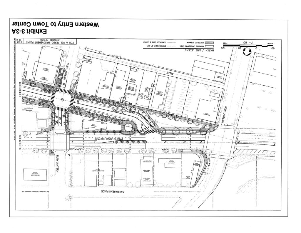
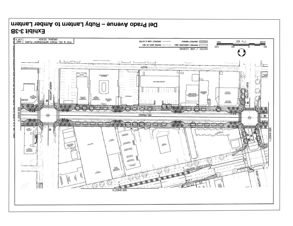
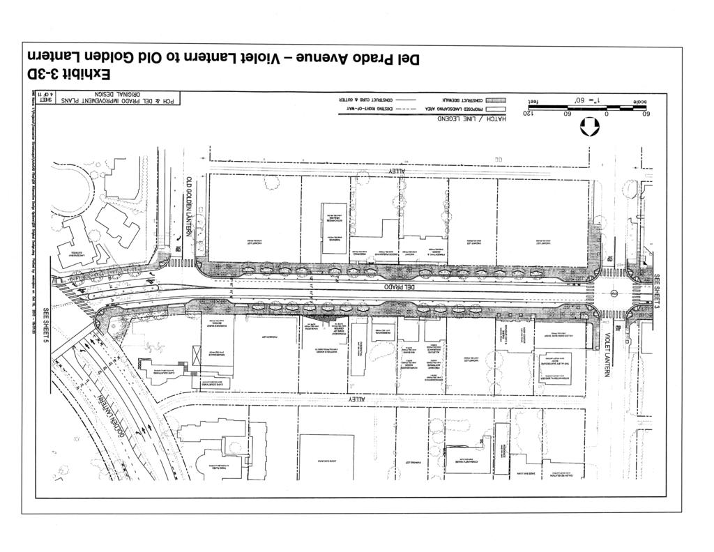
6 Pacific Coast Highway/Del Prado Avenue Phase I Street Improvement Project Chapter 3.0 Project Description properties. PCH will be constructed first and two-way operations established. Del Prado will remain open during construction albeit a single eastbound lane. Del Prado street curb relocation work will be undertaken in four increments, a quarter section at a time. Business Open and parking signage will be used as well as event publication to encourage customers to use businesses during the construction period. 3.4 Description of the Proposed Project The City of Dana Point is proposing the Pacific Coast Highway/Del Prado Avenue Phase I Streetscape Improvements for the Dana Point Town Center. The PCH/Del Prado Phase I Streetscape Improvement project ( Project ) is the initial project for ultimate street improvements identified in the approved Town Center Plan for these Circulation Element roadways. Implementation of the proposed project will reestablish two-way circulation for both PCH and Del Prado. Exhibit 3-3A through Exhibit 3-3K illustrate the Project Improvements proposed by the City. In addition to the return to two-way operations, the proposed improvements along PCH include traffic signal improvements/modifications, striping, and signing modifications, improved transit stops, and initial traffic and beautification related modifications to the gateways at Blue Lantern and Copper Lantern. The traffic signal improvements/modifications include new signals at Ruby Lantern and a new intersection between Blue Lantern and Ruby Lantern. In addition, modifications are also proposed at other traffic signals within the project area to accommodate the two-way travel proposed for the two arterials. Other improvements include the incorporation of landscaped medians, street improvements as needed to accommodate bus turnouts and u-turns at designated locations, the modification of certain vehicular access points and the relocation of some on-street parking. Some of these improvements will require acquisition of rights of way for sidewalk easements and parking, to accommodate the refined project design. The curb and gutter of PCH will generally remain in the existing location. A two-lane left-turn pocket will be included on southbound Golden Lantern at Pacific Coast Highway, along with other key signing and striping adjustments to accommodate the change to two way traffic and the associated traffic volumes. The improvements proposed for Del Prado also include the return of two-way operations, along with, additional on-street parking, streetscape beautification, and gateway improvements and attendant rightof-way acquisition where needed. Other general improvements include the incorporation of water quality and air quality enhancements with significant additional landscaped pervious areas, reduced lighting energy consumption, reduced long-term noise levels with reduced traffic speeds, landscaped medians, parkway landscaping, installation of new trees, protection of existing trees where possible, street light improvements, signage and banner poles, drainage and water quality enhancements, sidewalk enhancements, wall and retaining wall construction, pavement resurfacing, new curb and gutter, the modification of certain vehicular access points including relocation or closure of certain drive entries, and other miscellaneous improvements. Three existing traffic signals will be replaced with 4-way stop signs. The design is intended to enhance the pedestrian experience by widening sidewalks while improving onstreet parking between Blue Lantern and Golden Lantern. Pacific Coast Highway/Del Prado Avenue Phase I Street Improvement Project Dana Point, CA March
7
8
9
10
11
12
13
14
15
16
17
18 Pacific Coast Highway/Del Prado Avenue Phase I Street Improvement Project Chapter 3.0 Project Description The design concepts of the Town Center Plan call for rebalancing through-movement with public access, calming traffic, enhancing the pedestrian environment, and making the Town Center more readily accessible and navigable to residents and visitors to the area. Beyond the circulation and streetscape concept proposed by the City, the plan also includes improvements that are intended to enhance the use of existing businesses, strengthen the economic viability of the Town Center, and identify the Town Center as the hub of the community, consistent with the recommendations previously approved in the Town Center Plan. This will create a more vital and vibrant atmosphere in the Town Center. 3.5 Project Phasing Implementation of the proposed improvements is anticipated to begin as early as 2012 and extend through 2013; however, implementation is dependent on several factors, including the availability of funding and prevailing economic conditions, which could delay work for two or three more years. However, once funding is secured by the City of Dana Point, the proposed improvements will move ahead expeditiously in order to secure the significant benefits that flow from the project. Once funding is secured, construction activity is estimated to last 12 months. 3.6 Project Objectives Implementation of the proposed project will achieve the following intended specific objectives, which have been identified by the City of Dana Point that are intended to achieve the goals and objectives of the Dana Point Town Center Specific Plan. Improved overall traffic circulation and safety Street beautification Pedestrian enhancements to support mixed-use development Improved lighting and use of reduced energy LED lighting Improved drainage facilities Increased parking overall Improved ocean water quality Reduced long-term noise levels Improved access to bus and bicycle public transit Improved long-term air quality Improved accessibility 3.7 Project Processing Requirements and Requested Entitlements Project implementation will necessitate the approval of the following legislative and discretionary actions by the City's Planning Commission and City Council: Acquisition of rights-of-way Preparation of project construction drawings and approval of contracts for same Bidding and awarding of project construction contract Coastal Development Permit Pacific Coast Highway/Del Prado Avenue Phase I Street Improvement Project Dana Point, CA March
THREE MILE PLAN TOWN OF SUPERIOR COLORADO
 THREE MILE PLAN TOWN OF SUPERIOR COLORADO February 23, 2015 INTRODUCTION This document has been prepared by the Town of Superior, Colorado, to address the existing and proposed land uses within an approximate
Proposed Bicycle Lanes on Yonge Street from Queens Quay to Front Street
 STAFF REPORT ACTION REQUIRED Proposed Bicycle Lanes on Yonge Street from Queens Quay to Front Street Date: March 12, 2007 To: From: Toronto and East York Community Council Director, Transportation Infrastructure
A. CONCLUSIONS OF THE FGEIS
 Chapter 11: Traffic and Parking A. CONCLUSIONS OF THE FGEIS The FGEIS found that the Approved Plan will generate a substantial volume of vehicular and pedestrian activity, including an estimated 1,300
Site Location and Setting
 Memorandum Date: To: From: Subject: Kristy Le, Gary Black Steve Orem Santa Teresa County Park Historic Area Traffic and Parking Study Hexagon Transportation Consultants, Inc. has completed a traffic and
user s guide to Transportation Improvements in Astoria Planning Efforts outside Astoria for more information, contact:
 The Miles Crossing/ Jeffers Garden transportation plan (underway), will identify needed improvements to the Warrenton Astoria Highway and local street improvements to serve expected growth in the Miles
Lake Erie Commerce Center Traffic Analysis
 LOCATION: East of NYS Route 5 at Bayview Road Town of Hamburg Erie County, New York PREPARED BY: Wendel Companies 140 John James Audubon Parkway Suite 200 Amherst, New York 14228 January 2012 i ii Table
PURPOSE AND NEED (CONCURRENCE POINT 1) NEW CANADA ROAD PROJECT FROM STATE ROUTE 1 (U.S. HIGHWAY 70) TO U.S. INTERSTATE 40
 NEW CANADA ROAD PROJECT FROM STATE ROUTE 1 (U.S. HIGHWAY 70) TO U.S. INTERSTATE 40") PURPOSE AND NEED (CONCURRENCE POINT 1) NEW CANADA ROAD PROJECT FROM STATE ROUTE 1 (U.S. HIGHWAY 70) TO U.S. INTERSTATE 40 Project Description The primary purpose of this project is to improve the major
PURPOSE AND NEED (CONCURRENCE POINT 1) NEW CANADA ROAD PROJECT FROM STATE ROUTE 1 (U.S. HIGHWAY 70) TO U.S. INTERSTATE 40 Project Description The primary purpose of this project is to improve the major
4. Safety Concerns Potential Short and Medium-Term Improvements
 NH Route 104 Access Management Study Page 19 4. Safety Concerns Potential Short and Medium-Term Improvements Potential safety improvement strategies are listed by priority based on field observations by
FINAL. Bicycle/Pedestrian Feasibility Study City of DeBary Dirksen Drive Trail. Prepared For: Volusia County MPO
 City of DeBary Dirksen Drive Trail FINAL Prepared By: Reynolds, Smith and Hills, Inc. Prepared For: Volusia County MPO September 2007 Table of Contents INTRODUCTION...1 PROJECT PURPOSE AND SCOPE...2 PHYSICAL
MEMORANDUM. Lynn Hayes LSA Associates, Inc.
 MEMORANDUM To: Lynn Hayes LSA Associates, Inc. Date: May 5, 217 From: Zawwar Saiyed, P.E., Senior Transportation Engineer Justin Tucker, Transportation Engineer I Linscott, Law & Greenspan, Engineers LLG
Welcome Land Use Element... LU-1
 Welcome Land Use Element... LU-1 Land Use Plan... LU-3 Residential Land Uses... LU-12 Commercial Land Uses... LU-14 Mixed Use... LU-16 Industrial Land Uses... LU-18 Automobile-Related Land Uses... LU-19
Chapter 4.0 Alternatives Analysis
 Chapter 4.0 Alternatives Analysis Chapter 1 accumulated the baseline of existing airport data, Chapter 2 presented the outlook for the future in terms of operational activity, Chapter 3 defined the facilities
5.1 Traffic and Transportation
 5.1 When it opens in 2009, the Bellevue Nickel Improvement Project will increase the number of vehicles able to travel through the study area, improve travel speeds, and improve safety by reducing the
Macleod Trail Corridor Study. Welcome. Macleod Trail Corridor Study Open House. Presentation of Proposed Design Concepts
 Macleod Trail Corridor Study Welcome Macleod Trail Corridor Study Open House Presentation of Proposed Design Concepts Study Purpose Develop a corridor plan for Macleod Trail that aligns with The City s:
VI. ALTERNATIVES TO THE MASTER PLAN C. RENOVATED EAST BUILDING ALTERNATIVE
 VI. ALTERNATIVES TO THE MASTER PLAN C. RENOVATED EAST BUILDING ALTERNATIVE INTRODUCTION The Renovated East Building Alternative would include the continued use of the renovated West Building and the renovation
Construction Staging Adelaide Street West
 REPORT FOR ACTION Construction Staging Adelaide Street West Date: October 6, 2016 To: Toronto and East York Community Council From: Acting Director, Transportation Services, Toronto and East York District
CHAPTER 1 INTRODUCTION MORENO VALLEY GENERAL PLAN 1. INTRODUCTION. 1.1 What is a General Plan?
 1. INTRODUCTION 1.1 What is a General Plan? A General Plan is a comprehensive long-term strategy for the physical development of a city. It determines how land may be used and the infrastructure and public
SUTTER COUNTY. General Plan Update Technical Background Report
 SUTTER COUNTY General Plan Update Technical Background Report February 2008 SUTTER COUNTY GENERAL PLAN UPDATE TECHNICAL BACKGROUND REPORT PREPARED FOR: SUTTER COUNTY PREPARED BY: PBS&J IN PARTNERSHIP
CHAPTER 4 -- THE LAND USE PLAN: DESCRIPTIONS AND POLICIES FOR THIRTEEN PLANNING AREAS
 CHAPTER 4 -- THE LAND USE PLAN: DESCRIPTIONS AND POLICIES FOR THIRTEEN PLANNING AREAS NORTH CENTRAL CAC AREA LITTLE VALLEY ROAD TO JUG HANDLE CREEK PLANNING AREA This planning area includes Cleone, Noyo,
Airport Planning Area
 PLANNING AREA POLICIES l AIRPORT Airport Planning Area LOCATION AND CONTEXT The Airport Planning Area ( Airport area ) is a key part of Boise s economy and transportation network; it features a multi-purpose
Capital Improvement Plan
 PROGRAM DESCRIPTION: The represents City Council approved projects and includes each of the project's total costs and the estimated funding requirements for the next five years. Projects are funded by
VISTA AZUL- APPROVED 20 LOT TENTATIVE MAP
 Expansive Views Entitlements for 20 Residential Lots Previously Graded Entitled for 14 Detached Lots, 6 Townhome Units DOWNTOWN SAN DIEGO ASKING PRICE: $1,395,000 - OFFERS DUE JULY 14, 2017 Monterey Heights
Fuller/Fuller Heights Road Improvements
 Fuller/Fuller Heights Road Improvements Total Project Cost - $4.4M Project Description This project will construct a mini-roundabout at the intersection of Fuller Heights Road and Old Triangle Road to
FEASIBILITY CRITERIA
 This chapter describes the methodology and criteria used to evaluate the feasibility of developing trails throughout the study areas. Land availability, habitat sensitivity, roadway crossings and on-street
Chuckanut Ridge Fairhaven Highlands EIS Scoping Concerns
 Chuckanut Ridge Fairhaven Highlands EIS Scoping Concerns Coalition of Southside Neighborhoods CSN Comments for Fairhaven Highlands EIS Scope Hearing, Jan 16, 2008 1 Chuckanut Ridge Hilly Terrain: Potential
Section 106 Update Memo #1 Attachment D. Traffic Diversion & APE Expansion Methodology & Maps
 Section 106 Update Memo #1 Attachment D Traffic Diversion & APE Expansion Methodology & Maps I-65/I-70 North Split Interchange Reconstruction Project (Des. Nos. 1592385 & 1600808) Traffic Diversion and
Alternatives Analysis City of Newport Beach Sunset Ridge Park Project December 14, 2011
 Alternatives Analysis City of Newport Beach Sunset Ridge Park Project December 14, 2011 Alternatives Analysis for Vehicular Access: This report supplements the project s certified EIR s Alternatives Analysis.
CHULA VISTA DEVELOPMENT OPPORTUNITY. For Additional Information: Sean Bascom Lic#
 CHULA VISTA DEVELOPMENT OPPORTUNITY For Additional Information: Sean Bascom 619.916.9179 bascom@scc1031.com Lic# 01862044 Image TAVA Third Avenue Village is the heart of Chula Vista s historic downtown.
3. COLTA / HUGA CONNECTIONS - PRELIMINARY
 9 3. COLTA / HUGA CONNECTIONS - PRELIMINARY 3.1 COLTA The Chain of Lakes Trail Association (COLTA) trail, formerly identified as the Chester Spur Line, was completed and opened for use in June 2011. The
Abbott Rd Rehabilitation Phase II - Elmore Rd to Birch Rd
 Abbott Rd Rehabilitation Phase II - Elmore Rd to Birch Rd Project ID SOA07003 Department State of Alaska Project Type Improvement Start Date December 2017 Location Assembly: Section 4, Seats F & G, Assembly:
Longmont to Boulder Regional Trail Jay Road Connection DRAFT FINAL REPORT
 Longmont to Boulder Regional Trail Jay Road Connection DRAFT FINAL REPORT December 2018 Project Summary Boulder County, Colorado, in partnership with the City of Boulder, is evaluating options for multi-use
RESORT AREA STRATEGIC ACTION PLAN (RASAP) STEERING COMMITTEE MEETING - APRIL 3, 2019
 STEERING COMMITTEE MEETING - APRIL 3, 2019") RESORT AREA STRATEGIC ACTION PLAN (RASAP) STEERING COMMITTEE MEETING - APRIL 3, 2019 Welcome & Introductions - Deb Zywna AGENDA FY 20 Resort CIP Proposed Projects - Kathy Warren ORDFBC Design Guidelines
RESORT AREA STRATEGIC ACTION PLAN (RASAP) STEERING COMMITTEE MEETING - APRIL 3, 2019 Welcome & Introductions - Deb Zywna AGENDA FY 20 Resort CIP Proposed Projects - Kathy Warren ORDFBC Design Guidelines
Town of Oakfield Agricultural and Farmland Protection Plan
 SECTION III COMMUNITY OVERVIEW A. Regional Setting / Location The Town of Oakfield is located in the northwestern portion of Genesee County. Located west of New York's Finger Lakes, the Town is uniquely
230 CHURCH AVENUE CHULA VISTA, CA 91910
 Excellent Location Near Vibrant Third Avenue Village High Density Zoning Building Height up to 45 Lot size of 11,326 sqft Flat/Graded Lot Ease of Access to Utility Hookups Multiple Allowed Uses For Additional
Transportation TRANSPORTATION PROJECTS
 Transportation TRANSPORTATION PROJECTS Balls Ford Road Interchange Total Project Cost $142.9M This project includes the construction of a new diverging diamond interchange at Route 234 Bypass (Prince William
CHURCH AVENUE CHULA VISTA, CA 91910
 For Additional Information: Sean Bascom 619.916.9179 bascom@scc1031.com Lic# 01862044 CHURCH AVENUE CHULA VISTA, CA 91910 CHULA VISTA DEVELOPMENT OPPORTUNITY Excellent Location Near Vibrant Third Avenue
COASTAL CONSERVANCY. Staff Recommendation September 22, 2011 BAY AREA RIDGE TRAIL: HOOD MOUNTAIN TO HIGHWAY 12
 COASTAL CONSERVANCY Staff Recommendation September 22, 2011 BAY AREA RIDGE TRAIL: HOOD MOUNTAIN TO HIGHWAY 12 File No. 11-039-001 Project Manager: Betsy Wilson RECOMMENDED ACTION: Authorization to disburse
Pedestrian Safety Review Spadina Avenue
 STAFF REPORT ACTION REQUIRED Pedestrian Safety Review Spadina Avenue Date: October 13, 2015 To: Toronto and East York Community Council From: Director, Transportation Services, Toronto and East York District
Northeast Stoney Trail In Calgary, Alberta
 aci Acoustical Consultants Inc. 5031 210 Street Edmonton, Alberta, Canada T6M 0A8 Phone: (780) 414-6373, Fax: (780) 414-6376 www.aciacoustical.com Environmental Noise Computer Modelling For Northeast Stoney
Community Development
 Community Development City & Borough of Juneau Community Development 155 S. Seward Street Juneau, AK 99801 (907) 586 0715 Phone (907) 586 4529 Fax DATE: February 11, 2016 TO: FROM: Planning Commission
Northaven Trail Phase 2 Initial Project Overview
 Northaven Trail Phase 2 Initial Project Overview Partnership Project to extend existing Northaven Trail Improve Bike/Ped Connectivity On Dallas Trail Network Plan City and County Funding Oncor Texas Trails
Transportation Improvement District (TID) Exercise New Castle County Unified Development Code
 Exercise New Castle County Unified Development Code") Transportation Improvement District (TID) Exercise New Castle County Unified Development Code Churchmans Crossing TID How should New Castle County deploy Transportation Improvement Districts (TIDs)? Site
Transportation Improvement District (TID) Exercise New Castle County Unified Development Code Churchmans Crossing TID How should New Castle County deploy Transportation Improvement Districts (TIDs)? Site
COMMENT PERIOD INTRODUCTION
 To: Interested Persons From: Tom Buford File: Del Rio Trail Project Date: June 8, 2018 Community Development Department Reference: NOTICE OF PREPARATION OF AN ENVIRONMENTAL IMPACT REPORT FOR THE DEL RIO
1 PROJECT STATUS UPDATE 2 ND CONCESSION FROM BRISTOL ROAD TO DOANE ROAD TOWNS OF EAST GWILLIMBURY AND NEWMARKET
 Report No. 3 of the Regional Council Meeting of March 28, 2013 1 PROJECT STATUS UPDATE 2 ND CONCESSION FROM BRISTOL ROAD TO DOANE ROAD TOWNS OF EAST GWILLIMBURY AND NEWMARKET The recommends: 1. Receipt
Gold Coast. Rapid Transit. Chapter content. Chapter four Route selection and staging
 Chapter four Route selection and staging Gold Coast Rapid Transit Chapter four Route selection and staging Chapter content Route selection...73 Section one: Helensvale to Griffith University...74 Section
November 21, 2012 Barbara Kelleher, (954)
") November 21, 2012 Barbara Kelleher, (954) 777-4090 barbara.kelleher@dot.state.fl.us BROWARD COUNTY TRAFFIC IMPACT REPORT November 26 to November 30, 2012 FORT LAUDERDALE -- Construction and maintenance-related
November 21, 2012 Barbara Kelleher, (954) 777-4090 barbara.kelleher@dot.state.fl.us BROWARD COUNTY TRAFFIC IMPACT REPORT November 26 to November 30, 2012 FORT LAUDERDALE -- Construction and maintenance-related
STAFF REPORT. Airport Land Use Consistency Determination Betteravia Plaza. MEETING DATE: January 21, 2016 AGENDA ITEM: 8D
 STAFF REPORT SUBJECT: Airport Land Use Consistency Determination Betteravia Plaza MEETING DATE: AGENDA ITEM: 8D STAFF CONTACT: Andrew Orfila RECOMMENDATION: Adopt findings for the Betteravia Plaza project
Basic Project Information
 FY 2015-16 PROJECT DESCRIPTION FORM (2C) Submitting Agency: Loudoun County Basic Project Information Project Title: Loudoun County Parkway (VA Route 607) U.S. 50 to Creighton Rd. (2C) Project Type (check
FDOT Treasure Coast Traffic Impact Report
 July 22, 2016 Chuck McGinness, 954-777-4302 chuck.mcginness@dot.state.fl.us FDOT Treasure Coast Traffic Impact Report July 22 through July 29, 2016 TREASURE COAST Construction and maintenance-related lane
STAFF REPORT. Airport Land Use Plan Consistency Review: Santa Barbara Airport Master Plan. MEETING DATE: November 19, 2015 AGENDA ITEM: 7D
 STAFF REPORT SUBJECT: Airport Land Use Plan Consistency Review: Santa Barbara Airport Master Plan MEETING DATE: AGENDA ITEM: 7D STAFF CONTACT: Peter Imhof, Andrew Orfila RECOMMENDATION: Adopt findings
Sundance Square. Liberty Hill, Texas 78642
 RETAIL / OFFICE DEVELOPMENT OPPORTUNITY Bulk Sale of ±24 Acres at $4.00 / sq. ft. Existing Williamson CAD Tax Parcels Property Features Area of high residential development growth Situated at the entrance
Metrolinx Projects: Temporary Delegation for Long- Term Road Closures
 PW29.1 REPORT FOR ACTION Metrolinx Projects: Temporary Delegation for Long- Term Road Closures Date: April 24th, 2018 To: Public Works and Infrastructure Committee From: General Manager, Transportation
EAST VALLEY PARKWAY FOR SALE - RESIDENTIAL DEVELOPMENT OPPORTUNITY 3141 E. VALLEY PARKWAY ESCONDIDO, CA ACRE SITE $1,100,000
 3141 E. VALLEY PARKWAY ESCONDIDO, CA 92027-5219 3.31 ACRE SITE $1,100,000 OFFERING HIGHLIGHTS Valley High School Residential Development Opportunity Close to Frances Ryan Park & Multiple Schools Settled
Area Surrounding Maplewood Manor
 BAY CITY, MICHIGAN HOUSING COMMISSION Neighborhood Revitalization Plan Area Surrounding Maplewood Manor January 13, 2014 CITY COMMISSION DRAFT PLAN PRESENTATION BAY CITY, MICHIGAN 1 Planners Phil McKenna,
MEMORANDUM VILLAGE OF NORTHBROOK
 MEMORANDUM VILLAGE OF NORTHBROOK TO: Staff COPY: Village President & Board of Trustees Department Heads FROM: Richard Nahrstadt, Village Manager DATE: April 29, 2016 SUBJECT: STAFF BRIEFING WEEK OF April
Spadina Avenue Built Form Study Preliminary Report
 STAFF REPORT ACTION REQUIRED Spadina Avenue Built Form Study Preliminary Report Date: July 9, 2014 To: From: Wards: Reference Number: Toronto and East York Community Council Director, Community Planning,
CHULA VISTA DEVELOPMENT OPPORTUNITY. For Additional Information: Sean Bascom Lic#
 For Additional Information: Sean Bascom 619.916.9179 bascom@scc1031.com Lic# 01862044 CHULA VISTA DEVELOPMENT OPPORTUNITY Excellent Location Near Vibrant Third Avenue Village High Density Zoning Building
AGENDA ITEM 5 D WAKULLA ENVIRONMENTAL INSTITUTE (WEI) TRAIL FEASIBILITY STUDY
 TRAIL FEASIBILITY STUDY") March 19, 2018 AGENDA ITEM 5 D WAKULLA ENVIRONMENTAL INSTITUTE (WEI) TRAIL FEASIBILITY STUDY TYPE OF ITEM: Action STATEMENT OF ISSUE The Wakulla Environmental Institute (WEI) Trail is one of several trails
March 19, 2018 AGENDA ITEM 5 D WAKULLA ENVIRONMENTAL INSTITUTE (WEI) TRAIL FEASIBILITY STUDY TYPE OF ITEM: Action STATEMENT OF ISSUE The Wakulla Environmental Institute (WEI) Trail is one of several trails
Bloor Street West Rezoning Application for a Temporary Use By-law Final Report
 STAFF REPORT ACTION REQUIRED 3741 3751 Bloor Street West Rezoning Application for a Temporary Use By-law Final Report Date: June 12, 2007 To: From: Wards: Reference Number: Etobicoke York Community Council
Community Development Committee
 C Community Development Committee For the Metropolitan Council meeting of October 31, 2012 Committee Report Item:2012-316 ADVISORY INFORMATION October 16, 2012 Date Prepared: Subject: Intercity Regional
SUMMER VILLAGE OF SILVER SANDS. Municipal Development Plan
 SUMMER VILLAGE OF SILVER SANDS Municipal Development Plan Bylaw 253-2014 Adopted August 22, 2014 Summer Village of Silver Sands Municipal Development Plan Bylaw No. 253-2014 Page 2 1 INTRODUCTION 1.1 SETTING
FHWA P/N Guidelines. Corridor Relationship. Highway 22 Segment 1 - US 169 to CSAH 2 Relevance / Documentation of Need
 Highway 22 Segment 1 - US 169 to CSAH 2 Vehicle Mobility Congestion Intersection Congestion Existing Conditions - Based on Highway Capacity Manual methodology, corridor level of service is currently LOS
FDOT Treasure Coast Traffic Report through
 FDOT Treasure Coast Traffic Report 02 26 16 through 03 04 16 Kathleen Dempsey Fri 2/26/2016 2:56 PM To:Kathleen Dempsey ; 1 attachment 355 KB CR 714_Median Access Modifications.pdf;
EXISTING CONDITIONS A. INTRODUCTION. Route 107 Corridor Study Report
 II. EXISTING CONDITIONS A. INTRODUCTION The Route 107 study area extends from the south at Chestnut Street in Lynn approximately 3.7 miles to the north to Boston Street in Salem. The study area has three
Twin Oaks Valley Rd Windy Way
 & Twin Oaks Valley Rd Windy Way NE Corner of Twin Oaks Valley Rd & Windy Way San Marcos, CA 92069 TUCKER HOHENSTEIN, SIOR +1 760 930 7966 tucker.hohenstein@colliers.com JOHN WITHERALL +1 760 930 7927 john.witherall@colliers.com
OLDE CARLSBAD APPROVED 12 LOT TENTATIVE TRACT MAP
 Rare Development Opportunity in the Olde Carlsbad Neighborhood Ocean Views from Some Lots Lot Sizes 9,500 SF - 15,720 SF Area of New Home Prices From $1,121,000-$1,400,000 ASKING PRICE: $4,850,000 - OFFERS
STAFF REPORT. Airport Land Use Plan Consistency Review: Old Town Village Mixed Use Project City of Goleta. MEETING DATE: June 18, 2015 AGENDA ITEM: 5M
 STAFF REPORT SUBJECT: Airport Land Use Plan Consistency Review: Old Town Village Mixed Use Project City of Goleta MEETING DATE: AGENDA ITEM: 5M STAFF CONTACT: Peter Imhof, Andrew Orfila RECOMMENDATION:
US 380 FEASIBILITY STUDY
 US 380 FEASIBILITY STUDY Denton County CSJ(s): 0135-10-061, 0135-10-062 Public Meeting(s): January 15 & 22, 2019 WELCOME US 380 Denton County Feasibility Study DALLAS DISTRICT PUBLIC MEETING January 15
12, 14 and 16 York Street - Amendments to Section 16 Agreement and Road Closure Authorization
 REPORT FOR ACTION 12, 14 and 16 York Street - Amendments to Section 16 Agreement and Road Closure Authorization Date: April 27, 2018 To: Toronto and East York Community Council From: Senior Strategic Director,
CITY COUNCIL AGENDA MEMORANDUM
 To: Mayor and City Council From: Charles Ozaki, City and County Manager Prepared By: Kevin Standbridge, Deputy City and County Manager Katie Allen, City and County Engineer David Shinneman, Community Development
Construction underway. STATUS: 229 5,190 5,419 5,305 STIP REFERENCE #FR /01/2013
 FREDERICK COUNTY STATE HIGHWAY ADMINISTRATION -- Frederick County -- Line 1 PROJECT: I-7, Baltimore National Pike INTERSTATE CONSTRUCTION PROGRAM DESCRIPTION: Widen I-7 east of MD 355 to east of MD 144
St. Dennis Drive Conversion of Traffic Lanes to On- Street Parking and Bicycle Lanes
 STAFF REPORT ACTION REQUIRED St. Dennis Drive Conversion of Traffic s to On- Street Parking and Bicycle s Date: April 22, 2014 To: From: Wards: Reference Number: Public Works and Infrastructure Committee
Parking Amendments - Bay Street, between Harbour Street and Queens Quay West (York Street, Bay Street, and Yonge Street Ramp Removal)
") REPORT FOR ACTION between Harbour Street and Queens Quay West (York Street, Bay Street, and Yonge Street Ramp Removal) Date: October 26, 2017 To: Toronto and East York Community Council From: Acting Director,
REPORT FOR ACTION between Harbour Street and Queens Quay West (York Street, Bay Street, and Yonge Street Ramp Removal) Date: October 26, 2017 To: Toronto and East York Community Council From: Acting Director,
THE STATE OF GRAYSLAKE
 THE STATE OF GRAYSLAKE Presented by: Mayor Rhett Taylor January 23, 2014 The State of Grayslake Economic Development Transportation Village Center Plans Economic Development Cost Savings Programs: Village
City of Durango 5.8 FUNDING TRAILS DEVELOPMENT
 5.8 FUNDING TRAILS DEVELOPMENT The City has been successful in establishing dedicated local funding sources as well as applying for grants to develop the City s trail system, having received nearly $2.4
November 11, 2009 BY . Planning and Growth Management Department 110 Laurier Avenue West, 4 th Floor Ottawa, Ontario K1P 1J1. Dear Mr.
 November 11, 2009 Planning and Growth Management Department 110 Laurier Avenue West, 4 th Floor Ottawa, Ontario K1P 1J1 BY E-MAIL Attention: Mr. Don Herweyer Dear Mr. Herweyer: Reference: Abbott-Fernbank
SOUTH INTERCHANGE AREA
 Santaquin City General Plan 1 Location and Characteristics The South Interchange Area of Santaquin is located west of Interstate 15 and south of 500 South (Figure 1). It includes properties already annexed
FDOT Treasure Coast Traffic Impact Report March 25 through April 1, 2016
 March 25, 2016 Chuck McGinness, 954-777-4302 chuck.mcginness@dot.state.fl.us FDOT Treasure Coast Traffic Impact Report March 25 through April 1, 2016 TREASURE COAST Construction and maintenance-related
ELECTION SIGN GUIDELINES
 ELECTION SIGN GUIDELINES GUIDELINES FOR THE PLACEMENT OF FREE STANDING ELECTION SIGNS ON CITY OF LETHBRIDGE ROAD RIGHT OF WAY Definition An election sign is a temporary sign announcing or supporting political
COASTAL CONSERVANCY. Staff Recommendation March 25, 2004 SONOMA COUNTY COASTAL TRAIL, PHASE I. File No Project Manager: Richard Retecki
 COASTAL CONSERVANCY Staff Recommendation March 25, 2004 SONOMA COUNTY COASTAL TRAIL, PHASE I File No. 03-142 Project Manager: Richard Retecki RECOMMENDED ACTION: Authorization to disburse up to $455,000
Madison Metro Transit System
 Madison Metro Transit System 1101 East Washington Avenue Madison, Wisconsin, 53703 Administrative Office: 608 266 4904 Fax: 608 267 8778 TO: FROM: SUBJECT: Plan Commission Timothy Sobota, Transit Planner,
SUPPORT THE ROUTE 58 PPTA: A Good Investment in Virginia
 Project Profile: SUPPORT THE ROUTE 58 PPTA: A Good Investment in Virginia In 1989, the General Assembly established the Route 58 Corridor Development Program to enhance economic development potential across
Memorandum. To: From: cc: Date: November 7, Re: 1.0 Purpose and Organization of this Addendum. 2.0 Project Description
 Memorandum To: From: cc: Laura Prickett, Horizon Water and Environment Analette Ochoa and Wana Chiu, WRECO Parag Mehta, Kimley Horn Date: November 7, 2017 Re: Santa Cruz Route 1 Tier I and Tier II HOV
CHAPTER 4 -- THE LAND USE PLAN: DESCRIPTIONS AND POLICIES FOR THIRTEEN PLANNING AREAS
 CHAPTER 4 -- THE LAND USE PLAN: DESCRIPTIONS AND POLICIES FOR THIRTEEN PLANNING AREAS NORTH CENTRAL CAC PLANNING AREA 4.4 FORT BRAGG CITY LIMIT TO HARE CREEK PLANNING AREA (Includes Noyo) The Noyo community
Blueways: Rivers, lakes, or streams with public access for recreation that includes fishing, nature observation, and opportunities for boating.
 Parks, Open Space and Trails PRINCE WILLIAM COUNTY 2008 COMPREHENSIVE PLAN TRAILS PLAN CONTENTS The components of the trails plan are: Intent Definitions Goals, Policies, and Action Strategies Trails Map
Appendix L Technical Memorandum Aesthetics
 Technical Memorandum Aesthetics 1.0 AESTHETICS This section provides a discussion of the aesthetic resources in the vicinity of ARTIC. Aesthetics pertain to the elements that make a certain view pleasing
Citrus Heights Creek Corridor Trail Project. Trail Advisory Group Meeting #3 July 8, 2013
 Citrus Heights Creek Corridor Trail Project Trail Advisory Group Meeting #3 July 8, 2013 Agenda Introductions Recap: Community Workshop, Survey Findings, and TAG Field Trip Community Concern Discussion:
Welcome to the Illinois High-Speed Rail Chicago to St. Louis Construction Update Meeting. Today s meeting will provide an overview of the Program,
 Welcome to the Illinois High-Speed Rail Chicago to St. Louis Construction Update Meeting. Today s meeting will provide an overview of the Program, updates on construction to be held in this area, and how
STAGE 2 & 3 Pavement reconstruction within viaduct footprint, pavement widening and resurfacing N/S of viaduct footprint, sidewalk
 STAGE 1 Viaduct removal, deck replacement on the River Bridge, and approach of the Chicago River Bridge north to Roscoe) Maintain local access roadways - 1 lane in each direction A signed alternate route
CITY OF LYNDEN STORMWATER MANAGEMENT PROGRAM REPORT MARCH 1, 2016
 CITY OF LYNDEN STORMWATER MANAGEMENT PROGRAM 2015 WATER QUALITY MONITORING REPORT CITY OF LYNDEN 300 4 TH STREET LYNDEN, WASHINGTON 98264 PHONE (360) 354-3446 MARCH 1, 2016 This document serves as an attachment
SONOMA LOCAL AGENCY FORMATION COMMISSION 111 SANTA ROSA AVENUE, SUITE 240, SANTA ROSA, CA (707)
") SONOMA LOCAL AGENCY FORMATION COMMISSION 111 SANTA ROSA AVENUE, SUITE 240, SANTA ROSA, CA 95404 (707) 565-2577 www.sonomalafco.org Item 4.2 Staff Report Meeting Date: February 6, 2019 Agenda No. Item 4.2
SONOMA LOCAL AGENCY FORMATION COMMISSION 111 SANTA ROSA AVENUE, SUITE 240, SANTA ROSA, CA 95404 (707) 565-2577 www.sonomalafco.org Item 4.2 Staff Report Meeting Date: February 6, 2019 Agenda No. Item 4.2
SAN FRANCISCO MUNICIPAL TRANSPORTATION AGENCY
 THIS PRINT COVERS CALENDAR ITEM NO. : 10.4 DIVISION: Sustainable Streets BRIEF DESCRIPTION: SAN FRANCISCO MUNICIPAL TRANSPORTATION AGENCY Approving various parking and traffic modifications associated
LYNDHURST NEW URBAN DEVELOPMENT AREA STRUCTURE PLAN. Lyndhurst New Urban Development Area Structure Plan OUTCOMES AND PERFORMANCE STANDARDS
 APPENDIX 15.1-3 LYNDHURST NEW URBAN DEVELOPMENT AREA STRUCTURE PLAN Purpose of the Structure Plan Lyndhurst New Urban Development Area Structure Plan OUTCOMES AND PERFORMANCE STANDARDS LSP-P1 The District
Caliber Charter School VALLEJO, CA
 Traffic Impact Study Final Report Caliber Charter School VALLEJO, CA 21 June 2016 Prepared for: Prepared by: Traffic Engineering & Transportation Planning This report has been prepared and certified by
Part Three : COMMUNITY PLAN AREAS AND SPECIAL STUDY AREAS SACRAMENTO 2030 GENERAL PLAN. Introduction
 Special study Areas Part Three : COMMUNITY PLAN AREAS AND SPECIAL STUDY AREAS SACRAMENTO 2030 GENERAL PLAN Introduction Beyond the boundaries of the 2030 General Plan, the City has defined Special Study
Business Item No XXX. Proposed Action That the Metropolitan Council approve the Coon Creek Regional Trail Master Plan.
 Business Item No. 2015-XXX Metropolitan Parks and Open Space Commission Meeting date: July 7, 2015 For the Community Development Committee meeting of July 20, 2015 For the Metropolitan Council meeting
May 1, 2015 Meredith Cruz, (561) Palm Beach County Traffic Report May 1 through May 8, 2015
 Palm Beach County Traffic Report May 1 through May 8, 2015") May 1, 2015 Meredith Cruz, (561) 641-6440 mcruz@corradino.com Palm Beach County Traffic Report May 1 through May 8, 2015 Palm Beach County Palm Beach County traffic will be affected this week by ongoing
May 1, 2015 Meredith Cruz, (561) 641-6440 mcruz@corradino.com Palm Beach County Traffic Report May 1 through May 8, 2015 Palm Beach County Palm Beach County traffic will be affected this week by ongoing
URBAN DESIGN REPORT. Proposed Residential Development, Old Church Road, Caledon East
 Proposed Residential Development, Old Church Road, Caledon East TABLE CONTENTS: 1.0 DEVELOPMENT 1.1 Introduction-Analysis of Guiding Principles and Documents 1.2 Community Design and Architectural Design
SEWERS AND STORM DRAINS. Storm Drain Pipe Repair
 A D O P T E D C A P I T A L I M P R O V E M E N T P R O G R A M B U D G E T F I S C A L Y E A R 2 1 5-2 1 9 SEWERS AND STORM DRAINS Storm Drain Pipe Repair FY 215-219 Capital Improvement Program Description
rearranged (on same page)
") Airport/Facility Directory Southwest Current Edition: April 5 - May 31, 2012 deleted added rearranged (on same page) April 5 - May 31, 2012 February 9-9 April 5, April 5 - May 31, 2012 February 9-9 April
Airport/Facility Directory Southwest Current Edition: April 5 - May 31, 2012 deleted added rearranged (on same page) April 5 - May 31, 2012 February 9-9 April 5, April 5 - May 31, 2012 February 9-9 April