THE GUADIARO RIVER BASIN
|
|
|
- Dina French
- 5 years ago
- Views:
Transcription
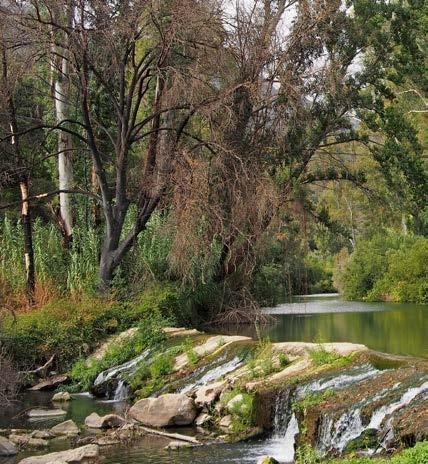
1 66 THE GUADIARO RIVER BASIN T he Guadiaro River is, together with the Genil, the largest river flowing through the province of Málaga. In addition, it bathes the shores of a good number of protected natural areas. It finishes its journey in the Mediterranean, near Sotogrande, in the municipal district of San Roque (Cádiz). The basin covers an area of 1,505 km 2 and the length of the watercourse is 82 km. The average flow rate is estimated at 30 m3/s, well above the rest of the rivers born in the province of Málaga. The highest source of the Guadiaro is located in the Sierra de las Nieves Natural Park, specifically in the Cañada del Cuerno, in the heart of Ronda s Spanish fir forest. Further down, it is joined by the Arroyo de la Fuenfría stream and other tributaries from the Sierra del Oreganal, including the Fuente de Malillo spring. From this point onwards it is called Río Grande. Soon it leaves the limestone mountains, carving the spectacular Cañón de Castillejos and entering Ronda s plateau under the name of Guadalevín. In the Paraje de la Indiana, the river is joined by an important tributary, the Guadalcobacín, formed among others by the Arroyo de la Ventilla, a very lively watercourse that has sculpted a beautiful and remarkably geo-diverse gorge, in the municipal district of Arriate. The confluence of the rivers Guadalevín and Guadalcobacín marks the geographical point where it takes the name Guadiaro, although some authors insist that it occurs a few kilometres further down, where it is joined by the river Gaduares after the Cueva del Gato. The next interesting landmark is the spectacular natural monument of the Cañón de las Buitreras, a canyon patiently carved through limestone rock over thousands of years. Slightly further south, in the municipal district of Cortes del la Frontera, it borders the Los Alcornocales Natural Park. From here, it leaves the Serranía de Ronda and enters the Campo de Gibraltar. The Guadiaro has two important tributaries, the Genal and the Hozgarganta. Both rivers combined are more important in terms of flow than any other of Málaga s rivers. The official source of the Genal River is the natural monument of the Nacimiento de Igualeja, a Vauclusian spring, and it is the backbone of the Genal Valley sub-region,
2 a perfect example of ethnology and agroforestry in the Mediterranean forest. The Hozgarganta River arises from the confluence of the Pasadallana and Pasadablanca springs, originating from the Sierra del Aljibe, the highest mountain in Los Alcornocales. In the Paraje de las Canillas, it leaves the province of Málaga and enters the Campo de Gibraltar. The Guadiaro Valley is part of the mosaic of natural and cultural landscapes of the Serranía de Ronda, famous for its important karst, dehesas and agriculture. Listing the line-up of natural assets of the Guadiaro river basin, according to the different ecosystems it flows through, is an arduous task, but we would like to mention some of them: the cork oak grove and its management in the three courses; the laurel forest type vegetation and Pyrenean oak groves linked to the upper course of the Hozgarganta; the presence of the Spanish fir tree in the Los Reales de Sierra Bermeja natural reserve, the home of the upper course of the river Almárchar, the Genal River s main tributary, and, in the Ronda-side of the Sierra de las Nieves Natural Park: the Havaral chestnut groves, in the upper Genal; the alder groves in the Guadiaro, Hozgarganta and Genal rivers, which are unique in the province of Málaga... Similarly, the three valleys offer their orientation and orography to the cyclical migrations of birds between the African and European continents, and create the perfect biotopes for the largest colonies of griffon vulture in Europe and for herbivores as interesting as deer, a local species of roe deer and mountain goat. The otter in these rivers never disappeared and some fish species maintain good populations, such as the Málaga chub (Squalius malacitanus), an endemic species of the Guadiaro river basin and some Sierra Bermeja rivers, and ray-finned fish such as the boga (Pseudochondrostoma willkommii) and the comilleja (Cobitis paludica). In historical terms, the rivers Guadiaro and Genal have acted as natural corridors used by different civilisations to gain access from the Atlantic and Mediterranean coasts to the immense natural wealth of the Serranía de Ronda. Prehistoric humans recorded their activities in the famous cave paintings of the Cueva de la Pileta. Phoenicians, Romans, Arabs and Berbers settled here, as well as the so-called romantic travellers of the Camino Inglés. Nowadays, touring the valley by train on the picturesque Algeciras-Ronda railway line is extremely enjoyable. 67
3

4 Río Guadiaro, on its way through Jimera de Líbar.
5 70 Freshwater pools in the Guadiaro river basin: Charco Frío, charco de la Barranca, charca de la Ermita, charca de la Llana, charca de la Zúa, charco del Moro, charco del Chalet, charco de las Pepas, charco Azul, charco de Moclón, charco Esteban, charco Puente de San Juan, charco de la Escribana, charco de Pontoco and charco del Tajo Molino. Other bathing areas in the Guadiaro river basin: Plozillo del Puente de la Ventilla. Río Guadalcobacín: a short distance from Ronda. Take the exit signposted between km 36 and 35 on the A-367 (Ronda-Ardales). Access is from the bridge on the old road. A path on one side of the bridge leads down to the Manantial de la Ventilla, and the swimming hole or Plozillo, as it is called in Arriate, is only a stone s throw away downstream. Charco Azul de Castillejos. Río Guadalevín: Following the Puerta Verde de Ronda to Marbella route, vehicular access is available to the Guadalevín ford. Up ahead, after 2.5 km, leave the dirt track and continue along the river bank. After 4 km, you will reach the two spectacular pools, of which the top pool, preceded by a waterfall, is the smallest. This was a much frequented location by the people of Ronda in years gone by. Pozas del Tajo. Río Guadalevín: Walking down the Camino de los Molinos starting from the Plaza de María Auxiliadora, along twisting footpaths with views of the impressive Puente Nuevo, eventually you will reach the Guadalevín River. There is a small irrigation dam here where you can swim. The largest pool lies upriver under a 30 m high waterfall. This place is not recommended for people that are not physically fit or that suffer from vertigo. Charco de la Cal. Río Seco: On the outskirts of Igualeja, following the MA-7300 road towards Pujerra, take the dirt track leading off to the left just after crossing the bridge over the Río Seco. 2.3 km later you will reach the Cortijo Algarca. You can reach this spot in

6 71 a four-wheel drive vehicle. On foot, walk downhill to the left down a steep slope to the river. Walk upstream for another 100 m or so to reach the pool, where sheep were also washed after sheering in years gone by. Arroyuela.

7 24 MEDITERRANEAN CATCHMENT AREA Río Genal / Gaucín CHARCO DE PONTOCO HOW TO GET THERE Taking the A-377 (Manilva-Gaucín), you will reach a bridge over the river Genal between kilometres 21 and 22. The lane leading to the pool is to the right just after you cross the bridge on your way to Gaucín. After a short drive through the floodplain, you will find the pool and space to park. 98

 often come up here from the Campo de Gibraltar in search of food. The pool is large enough to swim from one end to the other.")
8 99 Please Note INTERESTING FACTS From this point, the Genal leaves the rugged landscape behind, becoming broader and wider as it flows through the gentle hills and clay farmland. The Pontoco pool is made every year by means of a small earthen dam. You can spread your towel out under the shade of white poplars, willows and tamarisks. In this stretch of the Genal, apart from Spanish cane, there are some common alders (Alnus glutinosa), a species which is only found in the province of Málaga in the Guadiaro basin. Storks (Ciconia ciconia) often come up here from the Campo de Gibraltar in search of food. The pool is large enough to swim from one end to the other. It is not usually too deep for an adult to stand in the water. As in other freshwater pools, a rope hangs from a tree to swing from and plunge into the water. Please bear in mind that this can be dangerous. Towards the end of the summer the pool begins to show signs of drought and the amount of water taken from the river for irrigation purposes. Coordinates: x: / y: / z: 79 m Location: easy Access: convenient Protected Area: not included
THE GUADIARO RIVER BASIN
 66 THE GUADIARO RIVER BASIN T he Guadiaro River is, together with the Genil, the largest river flowing through the province of Málaga. In addition, it bathes the shores of a good number of protected natural
THE GUADIARO RIVER BASIN
 66 THE GUADIARO RIVER BASIN T he Guadiaro River is, together with the Genil, the largest river flowing through the province of Málaga. In addition, it bathes the shores of a good number of protected natural
GR-141 Gran Senda. in the Serranía de Ronda
 ACTIVE TOURISM 2. GR-141 Gran Senda in the Serranía de Ronda Long-distance trails or Senderos de gran Itinerary (commonly known by the abbreviation GR). They are long routes officially approved and signposted
THE COASTAL VALLEYS OF THE SIERRA BERMEJA MOUNTAIN RANGE
 106 THE COASTAL VALLEYS OF THE SIERRA BERMEJA MOUNTAIN RANGE T he Sierra Bermeja mountain range runs along the area between Manilva and Marbella, along the eastern reaches of the Málaga coast, consisting
MÁLAGA S RIVER BASINS
 13 MÁLAGA S RIVER BASINS M ost of Málaga s river basins are characterised by having their headwaters and springs in the main mountain chains, and for running a short distance before flowing into the sea,
THE GUADALHORCE RIVER BASIN
 42 THE GUADALHORCE RIVER BASIN T his is one of the most important rivers in Andalusia, both because of its length, over 165 km, and its flow rate, estimated at 8 m3/s. It has a vast basin of 3,160 km 2,
Parador de Ronda Surroundings
 PARADOR DE RONDA Parador de Ronda Surroundings The city beckons you to take a leisurely stroll that will allow you to visit the old Arab medina quarter on the southern bank of the Guadalevín River, cross
LA SIERRA GREENWAY AND WHITE WASHED VILLAGES. wwwgreenways4all.org
 LA SIERRA GREENWAY AND WHITE WASHED VILLAGES wwwgreenways4all.org V.V. SIERRA 3n/4d CHARMING WHITE WASHED VILLAGES Ronda, Olvera, Setenil de las Bodegas and La Sierra Greenway La Sierra Greenway, whose
Seville & Ronda 8-15 March 2016
 Seville & Ronda 8-15 March 2016 Cost per person 1360 - min 8 max 13 guests A week to discover this wonderful area of Spain where history has been made for centuries! Our journey is based in Seville, home
Dehesa Vieja and the Los Molinos area give us the gift of one of the finest
 ROUTE Dehesa Vieja and the Los Molinos area give us the gift of one of the finest beauty spots in our town. Recent history brings paradoxes: a short time ago, this place that now offers us so much beauty
GRANADA ALHAMBRA OF GRANADA FROM SEVILLA. Join a Group, and visit the Alhambra, Alcazaba, Palace and Generalife Gardens.
 GRANADA GRANADA ALHAMBRA OF GRANADA FROM SEVILLA Join a Group, and visit the Alhambra, Alcazaba, Palace and Generalife Gardens.(Duration: 12 Hrs) ITINERARY: Granada, a wonderful city where many civilizations
SOUTHERN SPAIN. Seville, Cadiz, Cordoba, Ronda, Malaga, Gibraltar, Granada
 SOUTHERN SPAIN Seville, Cadiz, Cordoba, Ronda, Malaga, Gibraltar, Granada SOUTHERN SPAIN Seville is the capital of Andalusia with streets and squares in the historic quarter which are lively and busy.
GR141 GRAN SENDA DE LA SERRANÍA DE RONDA SECTION 6: ALPANDEIRE RONDA. 6Alpandeire. Ronda
 GR141 GRAN SENDA DE LA SERRANÍA DE SECTION 6: ALPANDEIRE 111 6Alpandeire Ronda GR 141 GRAN SENDA DE LA SERRANÍA DE SECTION 6: ALPANDEIRE - LENGHT: 18,8 km DURATION: 7 h INCLINESS Total ascent: 1.622 m
PUBLIC PARTICIPATION AND ICM IN THE COASTAL AREA OF GUADIARO AND GUADALQUITON
 PUBLIC PARTICIPATION AND ICM IN THE COASTAL AREA OF GUADIARO AND GUADALQUITON 1. Introduction The area analysed in this study, in spite of the fact is only about 5.000 has, contains one of the most important
Wetland of Lakes Koronia and Volvi, by Themis Nasopoulou Ramsar Wetland of Lakes Koronia and Volvi
 Preliminary hour by- hour Schedule By Themis Nasopoulou Ecoguide-Journalist MSc Biological Diversity E-mail: nasthem1@hotmail.com Mob.tel.: 0030-6937122299 Ramsar Wetland of Lakes Koronia and Volvi Litohoro
The Vjosa River in Albania
 The Vjosa River in Albania Europe s Wild jewel - beautiful, unknown and threatened The extensive braided river section near Tepelena would drown in a reservoir of the future Kalivaç dam. (Romy Durst) Major
Countries Of The World: Spain
 Countries Of The World: Spain By National Geographic Kids, adapted by Newsela staff on 04.25.18 Word Count 677 Level 830L Image 1. The Puento Nuevo in Ronda, Spain. The bridge was built in the late 1700s
PLACES TO VISIT FROM SAN FRANCISCO, 71 IN DISTANCE ORDER (distance and driving times are approximate)
") PLACES TO VISIT FROM SAN FRANCISCO, 71 IN DISTANCE ORDER (distance and driving times are approximate) 1. Rio Chillar 2 km, 4 mins A peaceful walk close to the apartment. The Rio Chillar eventually flows
PLACES TO VISIT FROM SAN FRANCISCO, 71 IN DISTANCE ORDER (distance and driving times are approximate) 1. Rio Chillar 2 km, 4 mins A peaceful walk close to the apartment. The Rio Chillar eventually flows
Excursions COSTA DEL SOL
 Excursions COSTA DEL SOL ALFARNATEJO: MALAGA COUNTRYSIDE Pick Pick up up from from your your hotel hotel at the at the indicated time time to head to head towards towards La Axarquía, La Axarquía, the
ALMERÍA-Eurorando
 ALMERÍA-Eurorando 2015-2016 Organizer or Territorial Delegation: FAM Almería Delegation http://www.aqueatacamos.com/dalias/subindex.html Activity data Date: 04/10/2015 Place: Almería. Andalucia (Spain)
FINAL STAG E : 5 T H G R A D E
 NAME COURSE SURNAME CENTRE YOUR TEACHER S NAME FINAL STAG E : 5 T H G R A D E 1. Read Danny s diary and complete his timetable. Remember there are extra words! EXTINCT / WATERFALL / VALLEY / PATH / WOOD
Ole Ole Ole Viva Espana! September, 2019
 Guess Where? Ole Ole Ole Viva Espana! September, 2019 DAY 1 (THURSDAY) 05th SEPTEMBER 2019 ARRIVAL IN BARCELONA (-/-/-) Welcome to Barcelona! Upon arrival at the airport you ll be met by a local guide
The rewards more than make up for the efforts of seeing the country this is a truly unforgettable trek.
 MADAGASCAR TREK ORANGE 2 ABOUT THE CHALLENGE This exciting trek takes us to remote Madagascar, where spectacular scenery and amazing wildlife awaits! From canyons and gorges to bush-covered plains and
There are actually six geographic sub-regions, three in both the uplands and the lowlands.
 6 Regions of AR Although Arkansas is most easily divided into two distinct geographical regions, the northwestern uplands and the southeastern lowlands, this description does not accurately portray the
Europe s wild jewel - The Vjosa River in Albania
 SAVE THE BLUE HEART OF EUROPE THE BALKAN RIVERS Europe s wild jewel - The Vjosa River in Albania BEAUTIFUL, UNKNOWN AND THREATENED The extensive braided river section near Tepelena would drown in a reservoir
Welcome to cycling paradise
 Welcome to cycling paradise We are Runbaik Travel, an officially registered Travel Agency in Spain and the Junta de Andalucia Turismo, Nº RTA:: C. I. AN-116679-2. Runbaik is located in Andalusia, one of
GR 141 GRAN SENDA DE LA SERRANÍA DE RONDA SECTION 4: BENARRABÁ BENALAURÍA. 4Benarrabá. Benalauría
 GR 141 GRAN SENDA DE LA SERRANÍA DE RONDA SECTION 4: BENARRABÁ 77 4Benarrabá Benalauría GR 141 GRAN SENDA DE LA SERRANÍA DE RONDA SECTION 4: BENARRABÁ LENGHT: 12,3 km DURATION: 5 h INCLINESS Total ascent:
GRANADA 1 DAY TRIP. Página 1 INCLUDED
 1 DAY TRIP GRANADA Granada was the longest lasting Arab kingdom in Spain (almost 800 years), and the centenary of its reconquest by the Catholic Monarchs was celebrated in 1992. The city is known worldwide
Destination of the month:
 Destination of the month: COSTA DEL SOL, Luxury for everyone Feel the passion with RTA Why Costa del Sol? Málaga 3rd biggest Airport in Spain Short distance between main cities Sun all year around Traditional
Let s go to Spain offers you. Private tour to Ronda
 Let s go to Spain offers you Private tour to Ronda Gunvor 26/08/2014 PRIVATE TOUR FROM SEVILLE TO RONDA RONDA VISIT itself. Ronda is one of Spain s most important historic cities, perched on top of a high
Mills Pecos River Ranch 7800 Acres Val Verde County, Texas Situated along both sides of the Pecos River
 Mills Pecos River Ranch 7800 Acres Val Verde County, Texas Situated along both sides of the Pecos River James King, Agent Office 432-426-2024 Cell 432-386-2821 James@KingLandWater.com King Land & Water
COMPANIONS PROGRAMME 9CHLIE
 COMPANIONS PROGRAMME 9CHLIE Thursday 30 June 2005 10:00 13:00 Registration 16:30 Departure of the bus from the 16:30-21:00 Trip and visit to Puerto Marina, Mijas and Puerto Banus 21:00 Arrival of the bus
Blanco Creek Ranch Acres, Uvalde County, Texas
 Blanco Creek Ranch 1208.30 Acres, Uvalde County, Texas James King, Agent Office 432 426.2024 Cell 432 386.2821 James@KingLandWater.com Blanco Creek Ranch 1208.30 acres Uvalde County, Texas James King,
THE MOUNTAINS OF RONDA AND GRAZALEMA
 THE MOUNTAINS OF RONDA AND GRAZALEMA About the Author Guy Hunter-Watts has lived and worked in Andalucía since the 1980s. After studying at the universities of Santiago and Salamanca he taught English
Montes Obarenes-Sierra de la Demanda Natural Park
 Montes Obarenes-Sierra de la Demanda Natural Park One week route Burgos Province INTERESTING SIGHTSEEING - Monte Santiago Natural Monument - Montes Obarenes Natural Park - Waterfalls: Salto del Nervión,
Marbella Club Hotel, Golf Resort & Spa
 MARBELLA, SPAIN 2018 THE LEADING HOTELS OF THE WORLD 1 1 Located in the Southern Coast of Spain, between old town Marbella and Puerto Banús, the Marbella Club Hotel Golf Resort enjoys 325 days of sunshine
Welcome to Natural Bridge
 Welcome to Natural Bridge Richard R. Randolph IV www.r4capital.com Www.r4land.com 205-879-5517 Work 205-413-8805 Fax 6 Carla Circle Birmingham, AL 35213 rich@r4capital.com Introduction NATURAL BRIDGE 160
Alpujarras walking trip - Spain
 S-CAPE TRAVEL - EMAIL: INFO@S-CAPETRAVEL.EU - TELEPHONE +34 985846455 - WWW.S-CAPETRAVEL.EU style : level : duration : comfort : period: code: WALKING Selfguided 7 days Feb Mar Apr May Jun Aug Sep Oct
Trekking the W Route in Patagonia. 7 Days
 Trekking the W Route in Patagonia 7 Days Trekking the W Route in Patagonia On Patagonia's famous W route, you'll hike deep in the remote wilderness of southern Chile and experience the wondrous landscapes
14. Viewpoints. The network of viewpoints built in the Serranía de Ronda is. Network ACTIVE TOURISM
 ACTIVE TOURISM 14. Network Viewpoints The network of viewpoints built in the Serranía de Ronda is an original initiative which allows visitors to see emblematic places from the region. Otherwise it would
Ruta de Las Recoveras
 The History The recoveras were the women - and there were also men - who took the route between Casares and Gibraltar to sell local products and buy others to resell afterwards on their return. Gertrudis
2015 Brain Wrinkles. SS8G1b
 SS8G1b Georgia is a geographically diverse state that is divided into five regions. The first three regions (Appalachian Plateau, Valley and Ridge, and Blue Ridge) are in the mountains and foothills of
Italy - Sardinia's East Coast Hiking Tour 2018 Individual Self-Guided 8 days/7 nights
 Italy - Sardinia's East Coast Hiking Tour 2018 Individual Self-Guided 8 days/7 nights Unique walks between the mountains and the sea in Sardinia s Wild East are awaiting you. Picturesque, rugged, spectacular,
Hiking in Marbella ROUTES. Sendero Acequias del Guadalmina. Benahavís - Montemayor. Refugio de Juanar - Cruz de Juanar
 Hiking Routes ROUTES Sendero Acequias del Guadalmina Benahavís 4,52 km Hiking in Marbella Adventure beyond Marbella Club and discover the best routes for a day s walk through the city s historical and
ECUADOR ADVENTURES ANDES AND AMAZON MULTISPORT 6 DAYS TRIP HIGHLIGHTS:
 ECUADOR ADVENTURES Effort: Moderate. Easy. Activities: Mountain Biking, Whitewater Rafting, Hiking, Horseback Riding, Wildlife Seeking. Accommodations: Quality hotels, historic haciendas, and eco lodges
New development of luxury apartments, within walking distance of the beach and Duquesa Marina
 New development of luxury apartments, within walking distance of the beach and Duquesa Marina About the complex This sought after development offers high quality apartments in a fantastic location, within
COLOMBIA ADVENTURES SANTANDER ULTIMATE ESSENTIAL MULTISPORT 7 DAYS TRIP HIGHLIGHTS:
 COLOMBIA ADVENTURES Effort: Moderate to challenging Activities: Hiking, biking, rafting, rappelling, cultural exploration Santander is home to beautiful rolling mountains, deep canyons, fast-flowing rivers
MIRADOR DE ESTEPONA GOLF
 MIRADOR DE ESTEPONA GOLF SUN, BEACH, WELLNESS & GOLF A Real Estate Development of 54 modern and exclusive designed apartments and penthouses located in the area of Estepona Golf, 3 km from the beach and
MIRADOR DE ESTEPONA GOLF
 MIRADOR DE ESTEPONA GOLF SUN, BEACH, WELLNESS & GOLF A Real Estate Development of 54 modern and exclusive designed apartments and penthouses located in the area of Estepona Golf, 3 km from the beach and
Filming Andalusia: Spanish sun and scenic mountain landscapes
 Filming Andalusia: Spanish sun and scenic mountain landscapes Malaga overlooks the Mediterranean on Spain s Costa del Sol in Andalusia. The Location Guide was invited to spend a few days touring the region
Countries Of The World: France
 Countries Of The World: France By National Geographic Kids, adapted by Newsela staff on 03.26.18 Word Count 681 Level 780L Image 1: A view of the Eiffel Tower in Paris, France. Paris, or, "the city of lights,"
Just how big is Africa?
 The United States China India The United Kingdom Portugal Spain France Belgium Germany The Netherlands Switzerland Italy Eastern Europe Japan 11.7 million sq. miles Just how big is Africa? Chapter 18 Section
If you are looking for the ebook by Joern Stegen White Villages of Andalusia: In Southern Spain the "Pueblos Blancos" or White Villages are an
 White Villages Of Andalusia: In Southern Spain The "Pueblos Blancos" Or White Villages Are An Attractive Tourist Destination (Calvendo Places) By Joern Stegen READ ONLINE If you are looking for the ebook
Events Calendar 2018/2019
 2018/2019 ~ DECEMBER 1 2 3 4 5 6 7 8 9 Bank Holiday Bank Holiday *Market & Tree Lighting 10 11 12 13 14 15 16 *The Art of Christmas 17 18 19 20 21 22 23 *A Jazzy Sparkling Christmas 24 25 26 27 28 29 30
(Phase II) The house where my story begins:
 The house where my story begins:") (Phase II) The house where my story begins: by Casa Banderas An amazing story, right on the Costa del Sol The house that I ve always wanted At dospuntos, we create the home in which you want to begin
(Phase II) The house where my story begins: by Casa Banderas An amazing story, right on the Costa del Sol The house that I ve always wanted At dospuntos, we create the home in which you want to begin
ESIA Albania Annex Field Data Sheets Large Carnivores
 ESIA Albania Annex 6.2.1.8 Field Data Sheets Page 2 of 30 TABLE OF CONTENTS 6.2.1.8 Field Data Sheets... 3 Page 3 of 30 6.2.1.8 Field Data Sheets This Annex should be read in conjunction with Annex 4.1.
TRANS ALGARVE MTB. lagoon system that extends itself over 60km of coast with hundreds of different bird species. Discover the
 TRANS ALGARVE MTB AN ASTONISHING MTB ROUTE ALONG PORTUGAL'S SOUTHERNMOST REGION, FROM THE BORDER WITH SPAIN UNTIL SAGRES, WHERE YOU WILL REACH CAPE S. VICENTE. In the meantime, you will have a taste of
Countries Of The World: Mexico
 Countries Of The World: Mexico By National Geographic Kids, adapted by Newsela staff on 06.07.18 Word Count 638 Level 800L Image 1: The pyramids of Guachimontones in Jalisco, Mexico. Mexico is a country
5 STAGES AT TOPES DE COLLANTES
 5 STAGES AT TOPES DE COLLANTES ADVENTURE EXPERIENCE SPORT CHALLENGE LIFE NATURE The Cuba Jungle Trail Run is born with the idea of offering a Unique Experience in a totally Wild Environment. The race is
Hike at Pico Blanco Labor Day Weekend!
 Hike at Pico Blanco Labor Day Weekend! The Pico Blanco Hymn Here among the trees majestic Pleasures you will find On the trails of Pico Blanco With your friends and mine Trail the Eagle ever onward This
Events Calendar 2018/2019
 2018/2019 ~ OCTOBER 1 2 3 4 5 6 7 Bank Holiday *II Reggata Costa del Sol, Marbella 8 9 10 11 12 13 14 15 16 17 18 19 20 21 *Valderrama Golf Master 2018, Sotogrande *Stars Observation Malaga Mountains 22
Bonaqua Mountain Hardware Action Sprint 2013 Discovery Bay,Lantau The Course Route
 Bonaqua Mountain Hardware Action Sprint 2013 Discovery Bay,Lantau The Course Route The start is inside the Discovery Bay plaza and leads out to the main sandy beach where you will run to the end of the
Join us on a magical TOUR DE FRANCE: Paris, Fontainebleau, Ardèche, Calanques & Chamonix
 Join us on a magical TOUR DE FRANCE: Paris, Fontainebleau, Ardèche, Calanques & Chamonix on an exclusive adventure trip with the through a mix of spectacular activities: Hiking, rock- climbing, canyoning,
Countries Of The World: Mexico
 Countries Of The World: Mexico By National Geographic Kids, adapted by Newsela staff on 06.07.18 Word Count 659 Level MAX Image 1: The pyramids of Guachimontones in Jalisco, Mexico. Mexico is a country
Carson City Open Space APNs and , west of Deer Run Road bridge
 32 acres (See separate packet for information on this open space property) OPEN SPACE PROPERTY APNs 008-541-73 and 008-541-92 (north and south sides of the river) Morgan Mill Road River Access Area (parking
Costa Rica. Family Special
 Costa Rica Family Special Itinerary 8 Days 7 Nights Costa Rica Family Special San José Irazu Volcano Cartago Orosi Tapanti National Park Turrialba Sarapiqui La Paz Waterfall Gardens HIGHLIGHTS TOUR ESSENTIALS
Subject to sale, withdrawal, or error.
 The Crawford L Bar Ranch is located approximately 40 air miles west of Albuquerque, New Mexico. This ranch truly epitomizes the description of New Mexico being the Land of Enchantment. The topography and
Cycling Routes Marbella and sorroundings
 Cycling Activity ROUTES Beach Promenade Marbella, San Pedro de Alcántara 17 km Cycling Routes Marbella and sorroundings Marbella s cycle-friendly roads will allow you to explore the Costa del Sol from
EcoMod 2012 Seville, 4 th 6 th of July, 2012
 EcoMod 2012 Seville, 4 th 6 th of July, 2012 FIRST NAME: E-MAIL: PLEASE PRINT AND SEND THIS FORM BY FAX OR MAIL: VIAJES EL CORTE INGLÉS, S.A. CONGRESS DIVISION PHONE: 00 34 954 50 66 05 - FAX 00 34 95
Suitability: Start: Cumbres de San Bartolomé Finish: Hinojales Distance: 12.6 km Time: 4 hours. Difficulty: MIDE evaluation STAGE 4 : GR-48Huelva
 STAGE 4 : Cumbres Mayores /Hinojales This stage of the route is a very easy walk connecting Cumbres Mayores town to Hinojales, a small highland village. Still within the limits of the Sierra de Aracena
Colombia - Coffee Triangle and Medellin Multisport Adventure Tour (2017) Guided 6 days/5 nights
 Guided 6 days/5 nights") Colombia - Coffee Triangle and Medellin Multisport Adventure Tour (2017) Guided 6 days/5 nights From the rich tropical valleys of the Coffee Triangle to the snow peaked volcanoes in Los Nevados National
Colombia - Coffee Triangle and Medellin Multisport Adventure Tour (2017) Guided 6 days/5 nights From the rich tropical valleys of the Coffee Triangle to the snow peaked volcanoes in Los Nevados National
SS8G1 The student will describe Georgia with regard to physical features and location.
 SS8G1ab Standards SS8G1 The student will describe Georgia with regard to physical features and location. a. Locate Georgia in relation to the region, nation, continent, and hemispheres. b. Describe the
The Lower Prut Floodplain Natural Park (Romania)
") The Lower Prut Floodplain Natural Park (Romania) Gabriela Costea Natural Sciences Museum Complex Galati (Romania) & member of the Scientific Council of the Lower Prut Floodplain Natural Park The Prut The
The Lower Prut Floodplain Natural Park (Romania) Gabriela Costea Natural Sciences Museum Complex Galati (Romania) & member of the Scientific Council of the Lower Prut Floodplain Natural Park The Prut The
Vegan Travel OCT 2018 Post-Cruise-Tour 2
 Vegan Travel OCT 2018 Post-Cruise-Tour 2 Journey to Punta Arenas & Puerto Natales 4 Days Vegan Travel Germany (Head Office) Muensterstrasse 111, 48155 Muenster-Wolbeck, Germany vegan@vegancruises.eu UK@vegancruises.eu
beach. Make the ford and follow the trail out to the junction with Red Creek Tr in an open grassy area.
 Description: This is a moderate to slightly strenuous 22.8 mile backpack (add 2.6 miles if you do the packless out and back to the Lion s Head) that will have you exploring nearly every thing that is The
INDEX. Location Estepona Climate Beaches Seaport Gastronomy Natural environment The Golf Coast
 Estepona Málaga INDEX 03 04 05 06 07 08 09 10 Location Estepona Climate Beaches Seaport Gastronomy Natural environment The Golf Coast 11 12 14 15 16 17 18 19 21 22 23 25 Real views from the project 74
 Routes around Solsona The surroundings of Solsona, called el Vinyet, preserve an old mosaic of forests, fields, farmhouses and stone walls. The group of suggested routes has a low level of difficulty and
Suitability: Start: Hinojales Finish: Arroyomolinos de León Distance: 21.5 km Time: 6 hours and 40 minutes. Difficulty: MIDE evaluation STAGE 5
 STAGE 5 Hinojales /arroyomolinos de león This is one of the longest stages of this long distance route, the GR-48 Sierra Morena Trail. Nevertheless, hikers could break in Cañaveral de León town which locates
TransAlgarve Cycling MTB ADVENTURE NATURE
 TransAlgarve Cycling MTB ADVENTURE NATURE 2018 www.portugalnaturetrails.com info@portugalnaturetrails.com TransAlgarve Cycling MTB ADVENTURE NATURE DESCRIPTION A pure adventure through the deepest soul
ESPAÑA ANDALUCÍA EN FAMILIA. March 14-23, DAYS / 8 NIGHTS. (Dates of travel to be confirmed upon flight booking)
") ESPAÑA ANDALUCÍA EN FAMILIA March 14-23, 2018 10 DAYS / 8 NIGHTS (Dates of travel to be confirmed upon flight booking) DAY 1: DEPART (Wednesday) Fly overnight to Málaga. DAY 2: MÁLAGA (Thursday) Bienvenidos
ESPAÑA ANDALUCÍA EN FAMILIA March 14-23, 2018 10 DAYS / 8 NIGHTS (Dates of travel to be confirmed upon flight booking) DAY 1: DEPART (Wednesday) Fly overnight to Málaga. DAY 2: MÁLAGA (Thursday) Bienvenidos
THE UKHAHLAMBA / DRAKENSBERG PARK
 THE UKHAHLAMBA / DRAKENSBERG PARK The ukhahlamba / Drakensberg Park is situated in the province of KwaZulu-Natal and covers some 243 000 ha. This immense area protects some of the most magnificent natural
Phoenix Habitat Restoration Projects
 Phoenix Habitat Restoration Projects Spur Cross Ranch Cave Creek (Estergard) Regional Tree and Shade Summit March 9, 2010 Desert Riparian Ecosystems Healthy riparian areas like this once existed along
Segment 2: La Crescent to Miller s Corner
 goal of the USFWS refuges is to conserve, protect and enhance fish, wildlife and plants and their habitats for the continuing benefit of the American people. Refuge lands are used largely for fishing,
TREK CUBA 2008 TREK CUBA
 TREK CUBA 2008 TREK CUBA 1 ITINERARY- OUTLINE FOR BESPOKE TRIPS The time to visit Cuba is now. It beckons us all with its picturesque colonial towns, intriguing Afro- Cuban culture, rousing revolutionary
Rogue Gorge (Mt. Stella) Roadless Area-- T30S R3E (primarily in portions of Sections 23, 26, 33, 34 & 35)
 Roadless Area-- T30S R3E (primarily in portions of Sections 23, 26, 33, 34 & 35)") Rogue Gorge (Mt. Stella) Roadless Area-- T30S R3E (primarily in portions of Sections 23, 26, 33, 34 & 35) Rogue River-Siskiyou National Forest--High Cascades Ranger District Upper, higher elevation trail
Rogue Gorge (Mt. Stella) Roadless Area-- T30S R3E (primarily in portions of Sections 23, 26, 33, 34 & 35) Rogue River-Siskiyou National Forest--High Cascades Ranger District Upper, higher elevation trail
Chapter 2: El Dorado County Characteristics and Demographics
 Chapter 2: El Dorado County Characteristics and Demographics 2.1 Geographic Area and Demographics El Dorado County comprises 1,805 square miles with over half of the area in the Eldorado National Forest
Events Calendar 2019/20
 2019/20 ~ MARCH 1 2 3 Cádiz Carnival Cádiz until 10/03 Carnival 4 5 6 7 8 9 10 11 12 13 14 15 16 17 Spanish Film Festival Málaga until 24/03 18 19 20 21 22 23 24 Asparagus Season Kempinski Hotel Bahía
ECUADOR ADVENTURE (10d/9n)
") EXPLORANDES ECUADOR WILSON 547 Y DIEGO DE ALMAGRO QUITO ECUADOR www.explorandes-ecuador.com ECUADOR ADVENTURE (10d/9n) www.explorandes-ecuador.com DAY 1: QUITO Arrival in Quito and transfer to your hotel
EXPLORANDES ECUADOR WILSON 547 Y DIEGO DE ALMAGRO QUITO ECUADOR www.explorandes-ecuador.com ECUADOR ADVENTURE (10d/9n) www.explorandes-ecuador.com DAY 1: QUITO Arrival in Quito and transfer to your hotel
What Is An Ecoregion?
 Ecoregions of Texas What Is An Ecoregion? Ecoregion a major ecosystem with distinctive geography, characteristic plants and animals, and ecosystems that receives uniform solar radiation and moisture Sometimes
CWMGIEDD FROM ABERCRAVE
 Abercrave to Cwmgiedd Walk Page 1 Starting from The Abercrave Inn. Grid Ref: SN 824128 From the Abercrave Inn, an 11.3km (7 miles) walk to the foothills of the Cribarth Mountain, then through forest to
A Tour of the Valle del Gizio
 Walk 25 A Tour of the Valle del Gizio Walking time 5hrs 30mins (4hrs if Colle Mitra is omitted) Difficulty 2 (likely to be snowbound in winter months); 1 (if Colle Mitra is omitted) Ascent/descent 570m/570m
Andalucía Photography Adventure Nature Photography Adventures
 Andalucía Photography Adventure Nature Photography Adventures 29 September - 8 October 2018 Andalucía, that special region of Southern Spain, is steeped in history, varied in geography, and rich in longstanding
Charnley Explorer June 24 - July 15, 2018 Bachsten Creek and the Charnley River. Second draft: 14 November 2017
 Charnley Explorer June 24 - July 15, 2018 Bachsten Creek and the Charnley River. Second draft: 14 November 2017 The best part of the original section one is now part of out Gibb Road Gorges trip. The dates
Modern Luxury Design Villas in a Gated Community
 Modern Luxury Design Villas in a Gated Community La Cala Views is a new development located in the exclusive and much sought after area of La Cala de Mijas (Mijas Bay). It is a gated community with a remotely
Note: Coordinates are provided as Universal Transverse Mercator UTM Zone U21, North American Datum 1983 (NAD 83).
.") Northern Traverse Route Description The Northern Traverse (formerly the North Rim Traverse) is an unmarked and rugged backcountry hiking route. It is known be a demanding hike, because of its terrain and
Northern Traverse Route Description The Northern Traverse (formerly the North Rim Traverse) is an unmarked and rugged backcountry hiking route. It is known be a demanding hike, because of its terrain and
discover Genuine Montana The Last Best Place Great Falls Montana
 discover Genuine Montana The Last Best Place Great Falls Montana the grandest sight I ever beheld... 1805 Meriwether Lewis journal entry Resting on the high plains along Montana s Rocky Mountain Front
BISHOPSTONE CIRCULAR WALK
 BISHOPSTONE CIRCULAR WALK 4½ miles (7¼ km) - allow 2 hours (see maps on final pages) Introduction This walk is within the North Wessex Downs Area of Outstanding Natural Beauty and starts from the small,
TRIP REPORT SPAIN 2012 Part 2
 TRIP REPORT SPAIN 2012 Part 2 D G Chelmick Macromia Scientific Dec 2012 Introduction and Participants This year cannot be considered as one trip; it comprised four separate visits as follows: 1. 21 May
Sierra del Burro Recon November 2006 text and photos by Peter Sprouse
 Sierra del Burro Recon 22-26 November 2006 text and photos by Peter Sprouse Six of us set off from Austin/Buda/San Marcos on a Wednesday night, loaded into two Toyotas. Along for this adventure were Saj
2015 Brain Wrinkles. SS8G1b
 SS8G1b Standards SS8G1 The student will describe Georgia with regard to physical features and location. b. Describe the five geographic regions of Georgia; include the Blue Ridge Mountains, Valley and