Sierra del Burro Recon November 2006 text and photos by Peter Sprouse
|
|
|
- Lewis Brooks
- 5 years ago
- Views:
Transcription
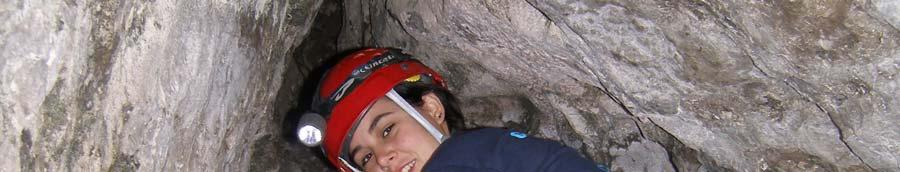
1 Sierra del Burro Recon November 2006 text and photos by Peter Sprouse Six of us set off from Austin/Buda/San Marcos on a Wednesday night, loaded into two Toyotas. Along for this adventure were Saj Pierson, Patrick Rhoades, Vickie Siegel, Bill Stone, Matt Zapitello, and me. We crossed the border at Piedras Negras without stopping: we weren t the droids they were looking for. Our first destination was the Rancho Veinticuatro, just north of Zaragoza. The ranch owner let us use his hunting lodge, so we slept on comfortable beds after a late game of billiards. The next morning his ranch hand drove down from farther in the ranch to guide us around the 24,000 hectares. This was mostly scrub country, with some wooded areas along drainages. Unfortunately this ranch was entirely in the plains and didn t extend into the hills, there was little karst even though there was plenty of limestone. He showed us two entrances that didn t extend in far enough to be called caves or contain troglobites. There was an artesian well that was spewing out quite a bit of water, but we couldn t find any interesting fauna in it. So we drove back to Zaragoza to look for more ranch owners. After some difficulty we got access to the Rancho las Cuevas some 20 km west of town. A fellow named Nino guided us to the one cave on the ranch, located behind the ranch house, then went back to town with the owner s brother. The cave was in a small bluff and was about 20 m long, a typical old seep-spring. We collected a lot of spiders in it that evening, then enjoyed a campfire on top of the bluff. The next day we went down to map the cave, which we called Cueva del Rancho las Cuevas for lack of any other name. Matt spotted a scorpion at the back but unfortunately it got away. We did get some tiny pseudoscorpions. After wrapping up there we went back to town to resupply and headed northwest to try to get to Rancho las Presitas, though we had no arrangements to get in. Fortunately the many gates were all unlocked, as there always
2 seemed to be more ranches up the road. The ranch hands at Las Presitas didn t know of any caves, so we headed into the hills to see for ourselves. We stopped at the first arroyo crossing to hike around a bit. I went upstream and found some pictographs in a small shelter with two entrances. As we drove farther into the ranch we checked other entrances out, but none went anywhere. A steel tank on top of a hill provided us with a needed swimming spot. Beyond that the road continued west down into the Cañon los Alamos, where tall limestone cliffs looked quite interesting. We stopped to camp under a cliff with some entrances perched above us. Patrick and I climbed up to check these out as it got dark. We climbed up to the first one, about 40 m above the canyon floor, three quarters of the way up the cliff. This entrance looked
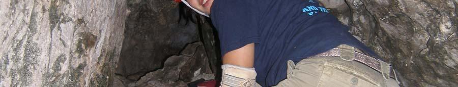
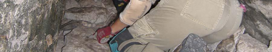
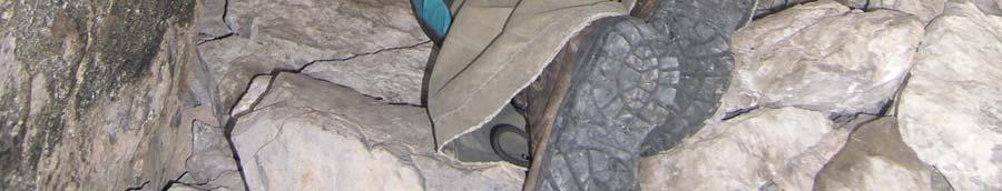
3 rather good, it was about 10m wide and headed into the cliff at an oblique angle to the right. What appeared to be old bear dung was scattered about the entrance. Cueva Popo de Oso went straight back along a fracture with a convoluted bedrock ceiling, usually walking height with low bedding plane areas off to the sides. After about 50 m it ended at a dome climb where someone had left a scaling pole, too short to get up the required 6 m. We collected some large spiders and some eyed pseudoscorpions. Then we climbed up to the next entrance just below the top of the cliff. This was just a shelter, so we climbed back down to camp. Saturday morning we checked some more entrances in a cliff face upstream. Cueva de Poca Calcita went in about 7 m and had a little flowstone in it. Bill went around to the top of the cliff and rigged a rope to get into another entrance, but it didn t go either. So we continued up the Cañon los Alamos to Rancho el Trebol and started to take a road that looked like it would lead over into the Cañon San Dabe, where El Abra (longest cave in Coahuila) is located, but we soon turned around and continued up the main canyon. Finally we were stopped by a locked gate at the Pedernales Ranch, said to be owned by Americans. Retreating down the canyon, we returned to the point where we had first joined the Cañon los Alamos. We followed a road that went downstream in this canyon. The very next cliff on the right had an interesting looking entrance in it so we parked the Toyotas and Bill began to cut a steep trail through thick brush up to the base of the cliff. After awhile he called down that the cave went, so the rest of us came up with survey gear. Pat, Saj and I arrived at the entrance to find Matt just inside, dropping an 8 m blind pit. The main level continued over this as a floorless canyon for a few meters, which someone had bridged with some sticks. The cave (Cueva Buena Pregunta) went another 10 m to end in flowstone. By the time we were done there it was dark, so we drove down to the next cobble beach and set up camp. We had another fine desert campfire that night under the Coahuila stars.
4 Saj at the entrance to Cueva Poca Calcita On Sunday we had to start heading home, but we did have time to check a few entrances on our way down the Cañon los Alamos, which our topo map indicated would take us back to the Rancho las Presitas. It wasn t long before we spotted an array of cliffside entrances on the right side of the canyon. Matt, Saj and I walked up to one of them, which went about 15 m. Matt, who is a big guy, pushed through a tight spot that he was rather worried about getting back out of. This inspired the named Cueva Preocupación. Although short, I did find a blind pseudoscorpion in this cave. Meanwhile Bill and Vickie tackled another cave, Flecha Negra, which required a bit of a climb to get into. Typical, it only went in 9 m. Driving on down the canyon, we were startled to see a large slot-like entrance on the left wall of the canyon heavily adorned with poison ivy, as if wellwatered. It was about 15 m tall by 10 m wide, with a spring drizzling water from high on the back wall over a tufa spout. On the right side of the shelter was a small statue of the virgin, her head exploded. To get up to the source of the water would require an overhung aid climb through poison ivy. Oh well, time to leave anyhow. Our trip on the ranch roads back to Zaragoza and our favorite Cocina Economica was quick, which was not the case crossing the border back into Texas amid holiday traffic.
5
6 Pat hiking up to Cueva Uña de Gato Matt forcing himself into Cueva Uña de Gato


7 Saj starts the survey of Cueva Preocupación
MUZQUIZ CAVING. Bear skull. by Philip Rykwalder and Peter Sprouse photos by David Ochel, Mark Sanders, Peter Sprouse
 MUZQUIZ CAVING Bear skull by Philip Rykwalder and Peter Sprouse photos by David Ochel, Mark Sanders, Peter Sprouse 2007 was a wet year across Texas and Coahuila, and this was evident on our Labor Day caving
POZO CHUZO The Black Hole of Coahuila by Jubal Grubb
 POZO CHUZO The Black Hole of Coahuila by Jubal Grubb The Pozo Chuzo trip started two years ago on a fateful day 1000 feet over the Coahuila desert in the summer of 1999. Earlier that year, while diligently
Silvertip 1996 By Peter Sprouse
 Silvertip 1996 By Peter Sprouse The north cirque of Silvertip Mountain. Photo by Peter Sprouse It had been quite a long time since I had been caving at Silvertip Mountain. The long drive from Texas, the
Coyote Gulch, Glen Canyon National Recreation Area, Utah, Spring Break 2009
 Coyote Gulch, Glen Canyon National Recreation Area, Utah, Spring Break 2009 This year, Jen and I decided to revive a tradition begun in our early years together: a yearly Spring Break trip to southern
CRANBERRY. Introduction
 Introduction Introduction The Cranberry Boulders are a group of 60 problems set in a beautiful mossy forest above the Cranberry Creek. The boulders are located approximately 36km south of Revelstoke on
Great Basin Drive, Yosemite to Las Vegas (C18A-3)
") Great Basin Drive, Yosemite to Las Vegas (C18A-3) After finishing up with the California parks, I left Yosemite and entered the Great Basin, which spans a large area east of the Sierra Nevada mountains
Great Basin Drive, Yosemite to Las Vegas (C18A-3) After finishing up with the California parks, I left Yosemite and entered the Great Basin, which spans a large area east of the Sierra Nevada mountains
Map of area and southern tip of Coronation Island
 Map of area and southern tip of Coronation Island In August of 2007, cavers Steve Lewis, Dan Monteith and David Love assisted Tim Heaton, University of South Dakota and Fred Grady, Smithsonian returned
Track Files a Wallys Initiative (reconnaissance mission) The Wallys Track Trip Report Easter 2017
 The Wallys Track Trip Report Easter 2017") Track Files a Wallys Initiative (reconnaissance mission) https://www.trackfiles.com.au/ - http://www.thewallys.net.au/ - https://www.ultimate4wdtraining.com.au/ The Wallys Track Trip Report Easter 2017
Track Files a Wallys Initiative (reconnaissance mission) https://www.trackfiles.com.au/ - http://www.thewallys.net.au/ - https://www.ultimate4wdtraining.com.au/ The Wallys Track Trip Report Easter 2017
Don Boyles personal Account of record setting jump.
 Don Boyles personal Account of record setting jump. About The Author Sept. 7, 1970 The Royal Gorge Parachute Jump Mr. Boyles is married and the father of four children, John 10, Jerry 8, Donna 5, and Sheila
INTERPRETING TOPOGRAPHIC MAPS (MODIFIED FOR ADEED)
") INTERPRETING TOPOGRAPHIC MAPS (MODIFIED FOR ADEED) Science Concept: Topographic maps give information about the forces that shape the features of Earth. Objectives: The student will: identify land features
INTERPRETING TOPOGRAPHIC MAPS (MODIFIED FOR ADEED) Science Concept: Topographic maps give information about the forces that shape the features of Earth. Objectives: The student will: identify land features
Airtime: 3.3. Airtime: 1.1
 Sunday, October 22, 2017 Cobra flight #607, PIC #620, 2 landings National Canyon, Havasu Canyon, Grand Gulch Bar10: Airtime: 3.3 10:44 am Bar10: 2:04 pm Sunday, October 22, 2017 Cobra flight #608, PIC
Hike at Pico Blanco Labor Day Weekend!
 Hike at Pico Blanco Labor Day Weekend! The Pico Blanco Hymn Here among the trees majestic Pleasures you will find On the trails of Pico Blanco With your friends and mine Trail the Eagle ever onward This
Another World, Underground: Carlsbad Caverns National Park
 Another World, Underground: Carlsbad Caverns National Park Welcome to This Is America with VOA Learning English. This week on our program, we explore a UNESCO World Heritage Site in the American Southwest,
Marten & Kelly Lakes 10 th Annual Daddy-daughter Backpacking Adventure
 Marten & Kelly Lakes 10 th Annual Daddy-daughter Backpacking Adventure I took my daughters to Marten and Kelly Lakes this year (mid July 2016) for our daddy-daughter overnighter. Marten Lake is west of
Glacier National Park, MT
 Glacier National Park, MT July 28 Aug. 1, 2010 We decided to go to Glacier National Park for our family vacation this year. We had a great time seeing beautiful scenery and a variety of wildlife which
Russell s Jatbula Trail Maintenance Special: March - April 2013
 Russell s Jatbula Trail Maintenance Special: March - April 2013 After walking the Jatbula Trail just after Christmas, I began to wonder if there might be some way to give something back to the park. I
Hiking Las Vegas.com
 Hike: Mt. Wilson via First Creek Canyon route Trailhead: First Creek marked Distance: 10 miles up and back Elevation gain: 3,400 feet Elevation of Peak: 7,070 feet Time: 7 to 9 hours (up and back) Difficulty:
2012 Oregon State Science Olympiad. B-Division Road Scholar Event National Wildlife Refuge Site Selection. Student Participants:
 2012 Oregon State Science Olympiad B-Division Road Scholar Event National Wildlife Refuge Site Selection Student Participants: School/Team: To answer the questions you will need a pencil, ruler, protractor,
The Nest Bouldering Guide By Marc Eveleigh Updated March 24 th, 2016
 The Nest Bouldering Guide By Marc Eveleigh Updated March 24 th, 2016 Introduction The Nest is a small bouldering area set in a neat section of canyon with a rushing stream. Originally called Mophead a
Arches of the. Sandflats Area. By Virginia Allen
 Arches of the Sandflats Area By Virginia Allen TABLE OF CONTENTS Introduction Dedication Road Log Arches 1. Perforated View Arch 2. Fee Booth Arch 3. Windsong Arch 4. Weird Arch 5. Resting Arch 6. Bike
He called the mayor of Plains. And he took the job. Then he asked about housing. He decided to rent a farmhouse. Rafael went to talk to Ana.
 C h a p t e r 1 Rafael Silva sat in his home office. He thought about the e-mail he just got. Plains, Kansas, needed a watering system. Plains had a lot of farms that needed water. Rafael had been asked
Witte Museum Tour Painted Shelter on the Rio Grande River Saturday June 2, :30 A.M. 3:00 P.M.
 Witte Museum Tour Painted Shelter on the Rio Grande River Saturday June 2, 2018 9:30 A.M. 3:00 P.M. This tour is limited to 35 participants (Ages 12 and up) All minors must be accompanied by a parent or
WORDS BY LUKE ARNOLD, PHOTOGRAPHY BY MATT HAWKE
 Southern SECRETS The scenery, history and 4WDing of this lesser-known region of the Victorian High Country will blow you away WORDS BY LUKE ARNOLD, PHOTOGRAPHY BY MATT HAWKE 038 038-043 Sth Alpine.indd
Charnley Explorer June 24 - July 15, 2018 Bachsten Creek and the Charnley River. Second draft: 14 November 2017
 Charnley Explorer June 24 - July 15, 2018 Bachsten Creek and the Charnley River. Second draft: 14 November 2017 The best part of the original section one is now part of out Gibb Road Gorges trip. The dates
Tumbler Ridge Global Geopark
 Tumbler Ridge Global Geopark WILDERNESS WATERFALLS These waterfalls are in remote locations, no trails exist, and GPS is required. Not every geosite needs a hiking trail. Providing ready access to all
The temperature is nice at this time of year, but water is already starting to be scarce.
 In March of 2003, Scott Morrison and I went backpacking in the Grand Canyon. The temperature is nice at this time of year, but water is already starting to be scarce. Another issue with this time of year
Saturday, October 27, 2018 Cobra flight #655, PIC #665, 2 landings Pueblo Viejo, Cebolita, Cerro Alto, High Lonesome
 Saturday, October 27, 2018 Cobra flight #655, PIC #665, 2 landings Pueblo Viejo, Cebolita, Cerro Alto, High Lonesome Belen: 7:53 am (MDT) St Johns: 9:32 am (MST) Airtime 2.7 hrs Cobra flight #656, PIC
Colorado Life Zone Scavenger Hunt
 Colorado Life Zone Scavenger Hunt Below are worksheets created for all the habitats or life zones. They were designed with the intention of breaking the class up into small groups, and having students
Region 1 Piney Woods
 Region 1 Piney Woods Piney Woods 1. This ecoregion is found in East Texas. 2. Climate: average annual rainfall of 36 to 50 inches is fairly uniformly distributed throughout the year, and humidity and temperatures
Emily Rose Pazosʼ Most Creative Winning Entry
 Emily Rose Pazosʼ Most Creative Winning Entry I climbed out of the snowdrift and brushed myself off. Whew! That was a close one! I was lucky not to have hit a tree when the front ski tips of my snowmobile
Jeff at Bar 10, trikes and planes in background. My trike. Living room, dining room Bar 10 Lodge
 Monday, October 23, 2017 Cobra flight #609, PIC #622, 4 landings Zion Canyon, Bruce Canyon, Escalante, Stevens Arch, San Juan Goosenecks, Bluff Dirt Road I got a great night sleep, and woke up a little
Mills Pecos River Ranch 7800 Acres Val Verde County, Texas Situated along both sides of the Pecos River
 Mills Pecos River Ranch 7800 Acres Val Verde County, Texas Situated along both sides of the Pecos River James King, Agent Office 432-426-2024 Cell 432-386-2821 James@KingLandWater.com King Land & Water
Castles, moats & waterfalls driving into a French fairytale
 Castles, moats & waterfalls driving into a French fairytale Crossing a drawbridge to enter the medieval 10 th century village of Entrevaux - my partner looked up at the citadel - then looked at me a little
INTRODUCTION ITINERARY ARGENTINA - TREKKING TO THE CLOUDS TRIP CODE ARTSTTC DEPARTURE DURATION. 4 Days LOCATIONS. Argentina
 INTRODUCTION Live this amazing experience in the NorthWest region of. Walking in the mountains through the ancient Inca trail, this journey will take you to discover ruins, spectacular views and landscapes.
2004 KOSCIUSKO/HECETA EXPEDITION
 THE ALASKAN CAVER Volume 26, Number 4 October, 2006 THE ALASKAN CAVER EDITOR: Carlene Allred 2525 Fourth Ave Ketchikan, Alaska 99901 hm: 907 225-1116 carleneallred@kpunetnet PRESIDENT: David Love 6740
Fire and Rock Art in the Helena National Forest
 Fire and Rock Art in the Helena National Forest Mavis Greer and John Greer Paper Presented at the 59 th Annual Meeting of the Plains Anthropological Society Lincoln, Nebraska November 2001 Natural forest
Setting Your Mirrors
 Setting Your Mirrors Mirrors are crucial to the safe driving of an RV. After all, the RV is usually significantly larger (longer, wider, and higher) than your normal daily vehicle. So even if you do not
Southwest Family Adventure. 7 Days
 Southwest Family Adventure 7 Days Southwest Family Adventure See three amazing National Parks Grand Canyon, Bryce, and Zion on this epic camping trip designed with families in mind. Every day offers magnificent
2016 Japan Home Stay. By Kailee Stinnett Harney County
 2016 Japan Home Stay By Kailee Stinnett Harney County When I First Got To Japan When I first got to Japan, we all stayed at a hotel and had an orientation to tell us about what was going to happen when
MGnews. March 2009 Volume 2, Number 3
 MGnews MONTGOMERY GROTTO March 2009 Volume 2, Number 3 Montgomery Grotto Officers P R E S I D E N T : STAN TEW NSS 18810 stan_tew@yahoo.com V I C E - P R E S I D E N T : JELENE FRANKLIN NSS 56086 jelenefranklin@gmail.com
Figure 1 Understanding Map Contours
 Figure 1 Understanding Map Contours The light brown lines overprinted on topographic maps are called contour lines. They indicate the elevation above sea level of land features and thus permit you to view
Maple Leaf School TRU Trip to Wells Gray Provincial Park. October 28+29, 2017
 Maple Leaf School TRU Trip to Wells Gray Provincial Park October 28+29, 2017 Twelve students, our principal, our principal s son, and I left Kamloops at 7:00 am on October 28 in two 8-seat rental transit
Reports. Big Elephants Afraid of Bees
 Reports You re going to read three news articles from the Web. nswer the questions after each text. Your answers must be in English. When you answer questions with alternatives choose ONE alternative only
Griffith Park Trail Run Trail Guide Click for
 The Griffith Park Trail Run by Hike- LosAngeles.com Griffith Park Trail Run Trail Guide Click for downloadable cell phone guide and map from EveryTrail. DISTANCE: 4.55 Miles ELEVATION: 1280' ELEVATION
Welcome to Natural Bridge
 Welcome to Natural Bridge Richard R. Randolph IV www.r4capital.com Www.r4land.com 205-879-5517 Work 205-413-8805 Fax 6 Carla Circle Birmingham, AL 35213 rich@r4capital.com Introduction NATURAL BRIDGE 160
ADVENTURE, education and fun!
 Camp Mornington ADVENTURE, education and fun! Why us? Camp Mornington provides the opportunity for ADVENTURE, education and fun in a beautiful and relaxing environment, just two hours from Perth. Camp
Architectural Analysis in Western Palenque
 Architectural Analysis in Western Palenque James Eckhardt and Heather Hurst During the 1999 season of the Palenque Mapping Project the team mapped the western portion of the site of Palenque. This paper
Pátzcuaro to Piedras Negras/Eagle Pass Part 2
 Pátzcuaro to Piedras Negras/Eagle Pass Part 2 Note 1: Northbound trip departure May 9, 2011. Approximate drive time 15 hours with overnight stop in Matehuala. Mileage is approximate and will vary based
World. Drive Holidays. Roadtrip Los Angeles to Orlando 17 Days / 16 Nights
 Coast 2 Coast - The Ultimate American Road Trip Roadtrip Los Angeles to Orlando 17 Days / 16 Nights Available Summer, Autumn, Spring For most of us, the term Road Trip takes us back to a simpler time in
Camp Geronimo Rainbow Trails
 Camp Geronimo Rainbow Trails With over 5,000 acres of surrounding national forest, the possibilities of getting out and seeing the wilderness are almost limitless. Camp Geronimo offers some of the greatest
Wednesday June 20, 2007
 Wednesday June 20, 2007 Woke up at 8:00 again today and got our carb filled breakfast (lemon bread). Ximena met up with us in Dan s room and told us we might be able to get in to see the museum tonight
Via Ferrata Madness in Quebec: Walking on the Iron Road
 Via Ferrata Madness in Quebec: Walking on the Iron Road Written by Juno Kim on June 17, 2016 So, let s talk about via ferrata. How many of you have done it or even heard of it? The first time I got to
TIPI SET UP INSTRUCTIONS 9 24 SIZE
 TIPI SET UP INSTRUCTIONS 9 24 SIZE You have purchased the most authentic, best-constructed tipi on the market. Before getting started, take a few moments and read this booklet completely!! You re about
We crossed over to the north and crossed over to the wide Piedra Valley. Mike passed over head and I snapped this picture of him (left).
.") Thursday, September 10, 2009 285th Cobra flight, 296th PIC, 3 landings Williams Lake, Weminuche Valley, Chimney Rock, Aztec, Navajo Airport, Pagosa Junction Pagosa: 8:40am Aztec: 11:05am Aztec: 11:55am
Thursday, September 10, 2009 285th Cobra flight, 296th PIC, 3 landings Williams Lake, Weminuche Valley, Chimney Rock, Aztec, Navajo Airport, Pagosa Junction Pagosa: 8:40am Aztec: 11:05am Aztec: 11:55am
Chapter 1 You re under arrest!
 Chapter 1 You re under arrest! My life is hell! Ryan thought. Most days weren t good, but today was worse than usual. He walked out of the corner shop with a packet of cigarettes. Sixteen-year-old Ryan
Summer Camp!! 4th & 5th Grade Musical March 17, 2015
 Summer Camp 4th & 5th Grade Musical March 17, 2015 Summer Camp Summer Campin. Goin to Summer Camp (sing 3 times) All my friends from far and near. Are packing up a ton of gear. Now s the day we leave for
My First 24 Hours in Thailand
 My First 24 Hours in Thailand by Kristin B. After months of packing up our lives in Texas, finishing our old jobs, packing suitcases, and reading about Thailand & Super English, we were finally on our
Friday October 3. Lower Javelina Trail - Level D. about 3 miles, less than 500. Hike Contact: Joel Tormoen
 Friday October 3 Lower Javelina Trail - Level D. about 3 miles, less than 500 Hike Contact: Joel Tormoen joeltormoen@gmail.com Depart WB trailhead 8:00 am - return before 11:00 am This quite easy hike
Draft II - Trip Report by Kurt Wibbenmeyer
 Draft II - Trip Report by Kurt Wibbenmeyer COLORADO MOUNTAIN CLUB FAIRWEATHER MOUNTAIN EXPEDITION 2010 TEAM Rich McAdams Leader Mike Butyn Wayne Herrick Gerry Roach Bill Blazek Dave Covill Jim Rickard
THE WITTE MUSEUM ROCK ART FOUNDATION 24th ANNUAL RENDEZVOUS February 23-25, 2018
 THE WITTE MUSEUM ROCK ART FOUNDATION 24th ANNUAL RENDEZVOUS February 23-25, 2018 Participation is limited to 130 guests. The format of the Rock Art Rendezvous will focus on site tours of the remarkable
Atrani, Italy and the Amalfi Coast
 Atrani, Italy and the Amalfi Coast Barcelona to Naples We left Barcelona in the early AM, tentatively locking the door of our rental flat behind us with the keys left inside as requested (and us hoping
Congewai Track Head (East) to Watagan Headquarters
 to Watagan Headquarters") Congewai Track Head (East) to Watagan Headquarters 7 hrs Hard track 17.2 km One way 4 973m This full day walk starts from the Congewai valley trackhead (east) and follows the Great North Walk up into the
Congewai Track Head (East) to Watagan Headquarters 7 hrs Hard track 17.2 km One way 4 973m This full day walk starts from the Congewai valley trackhead (east) and follows the Great North Walk up into the
Chapter One Alex watched a cricket creep along the baseboard and disappear. He didn t feel strong enough to go after it. Not today. Besides, why try?
 Chapter One Alex watched a cricket creep along the baseboard and disappear. He didn t feel strong enough to go after it. Not today. Besides, why try? Seven more crickets were on the loose, and he d lost
POSIO. Welcome to Posio, the magic land of Lapland.
 POSIO Embrace the forest changing by the season, experience the overwhelming sound of silence, enjoy heart-warming hospitality and get lost in mythical stories. Welcome to Posio, the magic land of Lapland.
Ronda and Grazalema. Monday, May 9, 2011
 Monday, May 9, 2011 Ronda and Grazalema With us dropping Seville and Granada from our schedule due to traffic considerations, Jan and I have only one goal left. That is to visit Ronda... and maybe Grazalema.
Etna winter expedition 1
 Etna winter expedition Etna, still active volcano. I ve been always tempted to climb it. I found a cheap flight ticket to Catania in February and I told myself why not in the winter! Two adventurous friends
Leura Cascades to Gordon Falls Reserve
 Leura Cascades to Gordon Falls Reserve 1 hr 15 mins 1.8 km One way Moderate track 200m From Leura Park to Gordon Falls Park, this diverse walk offers fantastic views of the Jamison Valley, as well as two
AOTA ArtTrek Locations
 AOTA ArtTrek Locations ArtTrek is a summer-long Grand County, CO art adventure. Highlighted by snow-covered mountain vistas and rolling meadows threaded with sparkling streams and rivers, numerous sites
Campfire Safety Guide
 Campfire Safety Guide August 27, 2018 https://montemlife.com/campfire-safety-guide/ 1/10 A crackling campfire is one of the most enjoyable parts of a camping trip. There s simply nothing like sitting around
Little Grand Canyon near Pomona, Illinois
 Little Grand Canyon near Pomona, Illinois Below: View of the trail and the terrain created using the Map My Hike app Below: Summary of the hike created using the Map My Hike app Presented by: Jennifer
Grizzly Peak A - East Ridge July 15, 2012
 Grizzly Peak A - East Ridge July 15, 2012 Difficulty: Difficult Class 2/Class 3 Upper Elevation: 13,995 feet Trailhead Elevation: 11,360 feet Elevation Gain: 3,000 feet Round-trip Length: 6.0 miles Trailhead:
Creepy Cave Crawlers. Scientists discover 27 new creatures in California's caves.
 Creepy Cave Crawlers photos.com Stalagmites rise from the ground. Stalactites resemble icicles and hang from a cave s ceiling. Scientists discover 27 new creatures in California's caves. California s newly
Southern Utah University Hike Brochure
 Southern Utah University Hike Brochure Taylor Creek Trail Twenty minutes from Cedar City Red Hollow An hour and a half from Cedar City Fees: Entrance fee to Kolb Canyon Length: 5 miles round trip Length:
Trails and Towers El Camino Real and the Verde Power Line in Santa Fe County
 Devin Bent, p 1 of 6, December 16, 2016. Introduction Trails and Towers El Camino Real and the Verde Power Line in Santa Fe County El Camino Real begins in Mexico City and travels 1600 miles north entering
ULTRA CABALLO BLANCO EXPERIENCE 2019
 ULTRA CABALLO BLANCO EXPERIENCE 2019 The Ultra Caballo Blanco race and the whole experience that accompanies the journey to the Barrancas del Cobre has become a true endurance runner pilgrimage. While
Waterproof Debris Shelter
 Bushcraft Video Series: David Styles, creator of 'Deep Nature Mentoring' presents Waterproof Debris Shelter Transcript Of Video 1. How Do We Make A Debris Shelter? Today we are going to learn about how
S2Kilimanjaro 8220 Barningham Road Richmond VA / /
 S2Kilimanjaro 8220 Barningham Road Richmond VA 23235 / 505.670.1441 Adventures @S2Mountaineering.com / www.s2mountaineering.com Lemosho Route The Lemosho Route is a remote, unspoiled and very beautiful
Internet TripTik. From : Zion National Park, Ut Stop At Stop At Stop At Stop At Stop At. : Bryce Canyon National Park, Ut : Arches National Park, Ut
 MAP: Overview Internet TripTik From : Zion National Stop At Stop At Stop At Stop At Stop At To : Bryce Canyon National Park, Ut : Arches National : Canyonlands National : Monument Valley, Utah : Kayenta,
Ranchers, Rattlers and Recharge
 Ranchers, Rattlers and Recharge Caving on the Phillips Ranch in Crockett County, West Texas By Sofia Casini Photos by Goeff Hoese and Peter Sprouse Participants: Don Arburn, Peter Sprouse, Ryan Reid, Geoff
W. T. Pfefferle. Published by Utah State University Press. For additional information about this book
 Poets On Place W. T. Pfefferle Published by Utah State University Press Pfefferle, T.. Poets On Place. Logan: Utah State University Press, 2005. Project MUSE., https://muse.jhu.edu/. For additional information
London Trip June 2011
 London Trip June 2011 Wednesday 22nd June 2011 COUPE GREEN PRIMARY SCHOOL Learning together, supporting each other After a tearful farewell, waving mums and dads off, we headed down the M6. We made great
Itinerary Overview. Continental Divide Alpine Backpacking 22 days Ages Course Description
 Itinerary Overview Continental Divide Alpine Backpacking 22 days Ages 16-18 Course Description Welcome, you re in for an experience of a lifetime! Imagine hiking through rolling forests, sharing alpine
YOSEMITE TO SAN FRANCISCO CYCLE
 USA CYCLE DEMANDING ABOUT THE CHALLENGE Journey from the spectacular Yosemite National Park to the Pacific Coast, finishing with an unforgettable finish at the iconic Golden Gate Bridge into San Francisco.
Our trip to Norway The report of the Austrian students
 Our trip to Norway The report of the Austrian students Thanks to Charlotte, our English assistant, for correcting the five texts and to Peter for compiling them. In March we (Laura, Lisa, Simon, David
Deep Inside. Copper Mine LEVELED READER P. Visit for thousands of books and materials.
 Deep Inside a Copper Mine A Reading A Z Level P Leveled Reader Word Count: 927 LEVELED READER P Deep Inside a Copper Mine copper ore malachite Written by Tony Francisco Visit www.readinga-z.com for thousands
What Is An Ecoregion?
 Ecoregions of Texas What Is An Ecoregion? Ecoregion a major ecosystem with distinctive geography, characteristic plants and animals, and ecosystems that receives uniform solar radiation and moisture Sometimes
Experience Report Study Abroad
 Experience Report Study Abroad In the fall semester of 2016 I signed myself up for an adventure: I went on Exchange. And not just an exchange, because I chose a city in a country that was almost as far
National Parks and Beyond
 National Parks and Beyond Canyons, Mesas and Hoodoos Nevada Utah Arizona Red Rock Canyon National Conservation Area Las Vegas, Nevada Begin your adventure under the neon lights of Las Vegas, an oasis in
Session 1 Reading. Directions. Session One 3 Go On
 Session 1 Reading Directions In this part of ELAP Plus Third Edition, you will read five passages: The Magnificent Taj Mahal An Unlikely Friendship Shapes in the Sand The Risks of Teens Driving Teens A
Fiberglass 80 meter Vertical BASE
 Fiberglass 80 meter Vertical - Revised: 2015-11-06 One antenna in use at K0MPH is a fiberglass 80 meter vertical. The supporting structure is made of fiberglass tubing but the radiation is from a wire
Patagonia Trek Itineraries. Patagonia Trek Itinerary: Trek #1 (Fly into/out of Punta Arenas) Day 1 December 26, 2017 Depart Home
 Day 1 December 26, 2017 Depart Home") 2017-18 Patagonia Trek Itineraries Patagonia Trek Itinerary: Trek #1 (Fly into/out of Punta Arenas) Day 1 December 26, 2017 Depart Home Day 2 December 27, 2017 Afternoon arrival in Punta Arenas. Overnight
2017-18 Patagonia Trek Itineraries Patagonia Trek Itinerary: Trek #1 (Fly into/out of Punta Arenas) Day 1 December 26, 2017 Depart Home Day 2 December 27, 2017 Afternoon arrival in Punta Arenas. Overnight
Example of the layout of a Fieldwork Atlas
 Example of the layout of a Fieldwork Atlas Example of a Worksite with multiple facilities and work goals in one area: Map Center 49 3 46 N 117 3 11 W Noname Area with typical travel route marked. Avalanche
Personal History. Curiosity Creek on the end of Jenal Road in 2003 (USF) Curiosity Creek in 2003 (USF)
 Curiosity Creek in 2003 (USF)") Oral history narrative from a joint program with Hillsborough County and the Florida Center for Community Design and Research Curiosity Creek The following narrative comes from an interview with long-time
Oral history narrative from a joint program with Hillsborough County and the Florida Center for Community Design and Research Curiosity Creek The following narrative comes from an interview with long-time
Jumping Through My Fear
 Sydney N. sydneynickell@q.com Literature and Composition March 18th, 2018 Jumping Through My Fear Wow! This is way too high. I don t know how I can do this. I remember thinking those exact words before
Fall 2017 Hiking Schedule All Hikes Depart From Pavilion Across From White Pine and Hemlock Lodges
 Pace Codes: Fall 2017 Hiking Schedule All Hikes Depart From Pavilion Across From White Pine and Hemlock Lodges Leisurely: Nature or historical walk; frequent stops for observation Moderate: Steady, 1 to
A to Z Mysteries: Detective Camp
 A to Z Mysteries: Detective Camp Here y are, kids, the taxi driver told Dink, ]osh, and Ruth Rose. Get out and stretch your legs and I ll fetch your luggage. The kids stepped out of the taxi in Bear Walk,
LOWER SPRING CANYON - CAPITOL REEF
 LOWER SPRING CANYON - CAPITOL REEF Rating: Moderate Hike Length: 5-7 hours (10-11 miles) Gear: Standard Hiking Gear Maps: Fruita, UT; Twin Rocks, UT; Water: A filterable spring a bit over 1/2 way. Recommend
Rongai 6 Days 5 Nights
 Rongai 6 Days 5 Nights The Rongai Route is one of the easiest routes and the success rate is very high. The route starts on the North side of the mountain just South of the Kenyan border and is one of
Trip Report: Backpack to East Boulder Lake in California Trinity Alps, July 7-9, 2016
 Trip Report: Backpack to East Boulder Lake in California Trinity Alps, July 7-9, 2016 Trekkers: Richard Hales, Aleece Townsend, Carol Mockridge, Rosalie Rybka, Elisabeth Zinser Day 1: Richard and Aleece
Itinerary Overview. Sangre de Cristo Alpine Backpacking 22 days Ages Course Description
 Itinerary Overview Sangre de Cristo Alpine Backpacking 22 days Ages 16-18 Course Description Welcome, you re in for an experience of a lifetime! Imagine hiking through rolling forests, sharing alpine meadows