C H A P T E R 3 R E V I E W O F E X I S T I N G T R A N S P O R T A T I O N F A C I L I T I E S
|
|
|
- Solomon Neal
- 5 years ago
- Views:
Transcription
1 C H A P T E R 3 R E V I E W O F E X I S T I N G T R A N S P O R T A T I O N F A C I L I T I E S INTRODUCTION As part of the planning process, an inventory of the existing transportation system in Klamath County was compiled. The inventory data came from a variety of sources, and includes data collected in the field to develop this TSP. A comprehensive roadway inventory was conducted for all major roadways within Klamath County. This detailed inventory is included in the appendix, and includes information about each inventoried road segment. Separate appendices list all of the relevant roadways in the county; this additional listing provides pavement types (paved, gravel, or unimproved), and the overall length of the road. In addition, information was compiled about the freight system (trucks and rail), county and state bridges, air transportation, bicycle and pedestrian facilities, public transit, pipelines, and fiber optic facilities. JURISDICTION AND ROADWAY DESCRIPTION Roadways included in this TSP fall under several jurisdictions, as previously listed. Table 3-1 shows roadways that are under the jurisdiction of ODOT and their functional classification: Table 3-1. ODOT Highways in Klamath County Route Name State Highway Cross Reference # ODOT Functional Classification US 97 The Dalles-California 4 Statewide Highway, Expressway OR 58 Willamette 18 Statewide Highway, Expressway OR 31 Fremont 19 Regional Highway OR 140 Klamath Falls-Lakeview 20 Statewide Highway OR 66 Green Springs 21 District Highway OR 62 Crater Lake 22 District Highway OR 70 Dairy-Bonanza 23 District Highway OR 39 Klamath Falls-Malin 50 Statewide Highway OR 138 North Umpqua 138 Regional Highway OR 140 Lake of the Woods 270 Statewide Highway OR 140 South Klamath Falls 424 Statewide Highway, Express Way 420 Midland 420 District Highway 422 Chiloquin Highway 422 District Highway OR 39 Hatfield 426 Statewide Highway 429 Crescent Lake 429 District Highway Klamath County Transportation System Plan Page 3-1
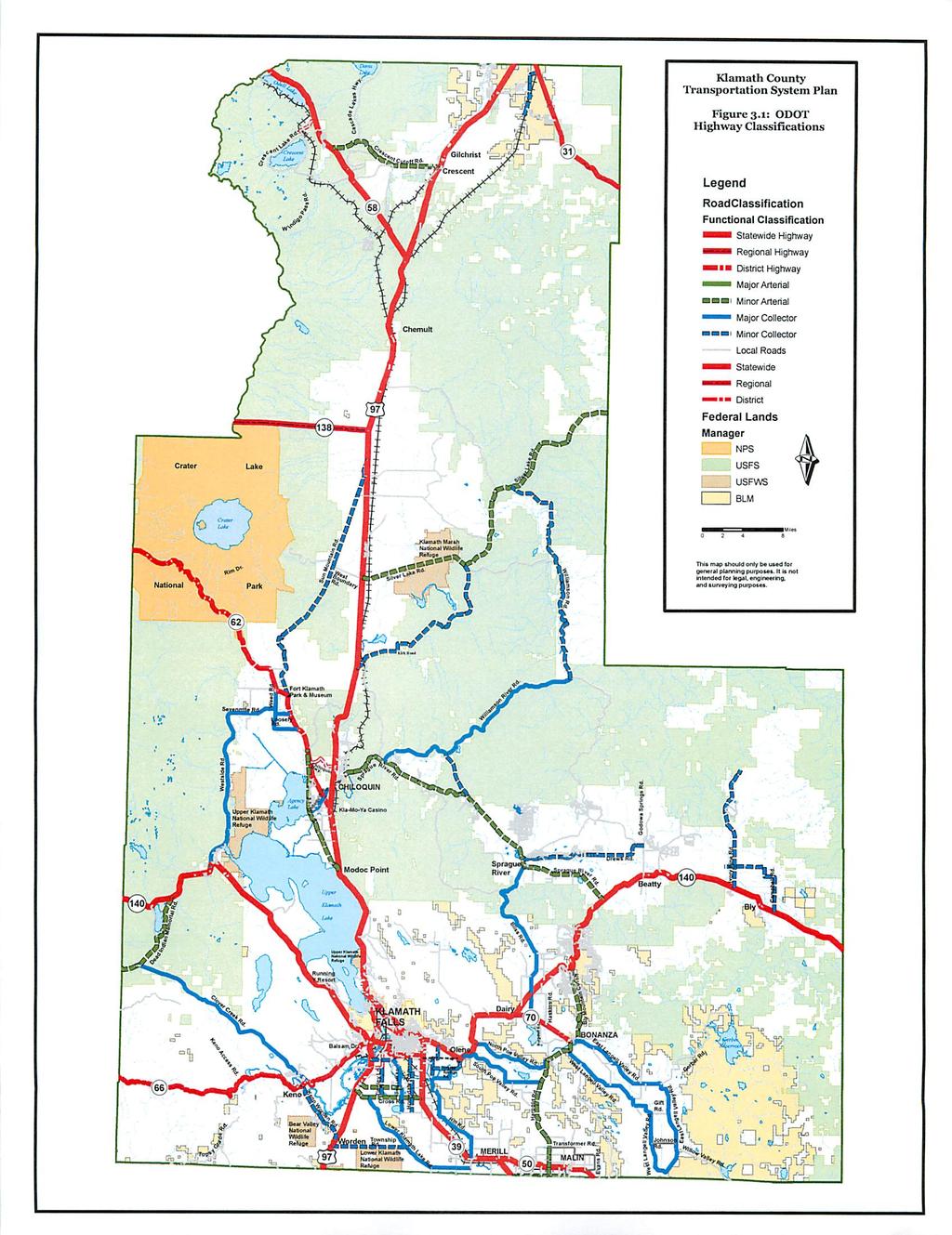
2 Figure 3-1 lists ODOT highways in Klamath County; following are descriptions of these highway classifications from the Oregon Highway Plan: Statewide Highways (NHS) typically provide inter-urban and inter-regional mobility and provide connections to larger urban areas, ports, and major recreation areas that are not directly served by Interstate Highways. A secondary function is to provide connections for intra-urban and intra-regional trips. The management objective is to provide safe and efficient, high-speed, continuous-flow operation. In constrained and urban areas, interruptions to flow should be minimal. Inside Special Transportation Areas (STAs), local access may also be a priority. Regional Highways typically provide connections and links to regional centers, Statewide or Interstate Highways, or economic or activity centers of regional significance. The management objective is to provide safe and efficient, highspeed, continuous-flow operation in rural areas and moderate to high-speed operations in urban and urbanizing areas. A secondary function is to serve land uses in the vicinity of these highways. Inside STAs, local access is also a priority. Inside Urban Business Areas, mobility is balanced with local access. District Highways are facilities of countywide significance and function largely as county and city arterials or collectors. They provide connections and links between small urbanized areas, rural centers and urban hubs, and also serve local access and traffic. The management objective is to provide for safe and efficient, moderate to high-speed continuous-flow operation in rural areas reflecting the surrounding environment and moderate to low-speed operation in urban and urbanizing areas for traffic flow and for pedestrian and bicycle movements. Inside STAs, local access is a priority. Inside Urban Business Areas, mobility is balanced with local access. Expressways primary function is to provide for interurban travel and connections to ports and major recreation areas with minimal or no delays. A secondary function is to provide for long-distance and intra-urban travel in metropolitan areas. OVERVIEW OF STATE HIGHWAYS State highways often function as major arterial streets forming the primary roadway network within and through a region. They provide a continuous road system that distributes traffic between cities. In Klamath County, the state highways/major arterial streets often serve statewide, regional, and local traffic demands combined. Although Klamath County has no direct control over the state highways, the highways heavily influence adjacent land use and traffic patterns across the county. Therefore, any recommended improvements in this TSP should be implemented with the cooperation of both state and county agencies. Klamath County Transportation System Plan Page 3-2


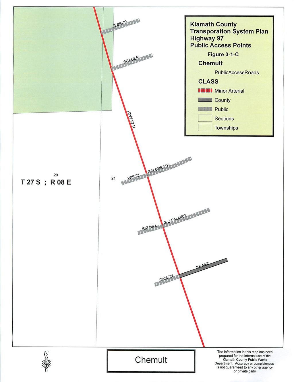
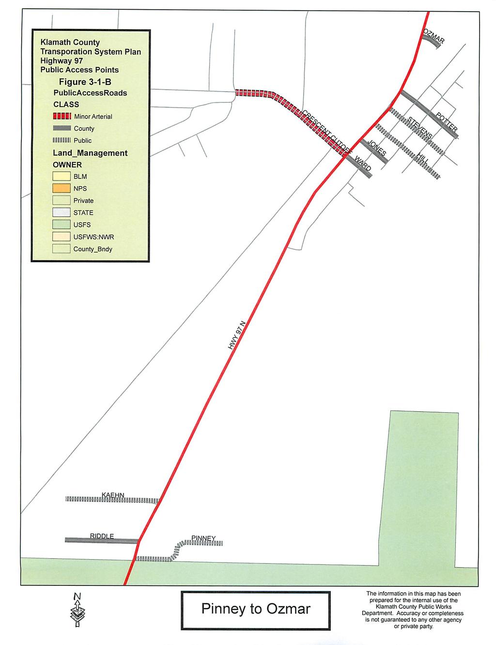
3 Following are a series of photos that document and describe the existing conditions of state highways in Klamath County: US Highway 97 (The Dalles-California Highway #4) runs north-south through the entire county and is classified by ODOT as a Statewide Highway and Expressway. The roadway width varies from one to two lanes in each direction, and posted speeds range from 40 mph to 55 mph. Cities and Communities that are served by US 97 include, Gilchrist, Crescent, Chemult, Chiloquin, Beaver Marsh, Klamath Falls, Midland, and Worden. US 97 is a designated State Freight Route and expressway. See figures 3-1, A-I for public roads that access Hwy 97 in North Klamath County. US 97 & Crescent Cutoff Rd., from Crescent Cutoff Rd. looking east US 97 & Silver Lake Rd., from Silver Lake Rd. looking west Klamath County Transportation System Plan Page 3-3
4 US 97 & Keno Worden Rd., from Keno Worden Rd. looking east Oregon Highway 140 runs east-west through the county and connects Klamath Falls to Medford and I-5 (as the Lake of the Woods Highway #270 and South Klamath Highway # 424) and Lakeview (as the Klamath Falls Lakeview Highway #20). ODOT has classified this road as a Statewide Highway and Statewide Highway and Expressway (Highway # 424 Milepost 0.0 to 567),OR 140 generally has one lane in each direction and posted speeds range from 30 mph to 55 mph. Cities and communities served by OR 140 include Rock Point, Klamath Falls, Olene, Dairy, Beatty, and Bly. OR 140 is designated State Freight Route. OR 140 & Sprague River Rd., from Sprague River Rd. looking south Klamath County Transportation System Plan Page 3-4
 runs southeast out of Klamath Falls through Merrill, and then continues south to California.")
5 OR 140 & Bliss Rd., from Bliss Rd. looking south Oregon Highway 39 (the Klamath Falls-Malin Highway #50 & Hatfield Highway # 426) runs southeast out of Klamath Falls through Merrill, and then continues south to California. ODOT has classified this road as a Statewide Highway. OR 39 generally has one lane in each direction, and posted speeds range from 30 to 55 mph. This section of OR 39 is designated State Freight Route. The Klamath Falls Malin Highway continues east where it connects to the City of Malin and California. After Milepost 16.51, OR 50 is classified as a District Highway by ODOT. The highway generally has one lane in each direction, and posted speeds range from 20 to 55 mph. Oregon Highway 138 (North Umpqua Highway # 138) travels west from US 97 along the north side of Crater Lake National Park to the junction of Oregon Highway 230 near Diamond Lake. Its primary function is to provide recreation access connection between US 97 and I-5. ODOT has classified OR 138 as a Regional Highway. OR 138 has one lane in each direction and the posted speed limit is 55 mph. Klamath County Transportation System Plan Page 3-5
6 US 97 & OR 138 (Diamond Lake Junction), from OR 138 looking east Oregon Highway 62 (Crater Lake Highway #22) is classified by ODOT as a District Highway and connects Crater Lake National Park and connects to US 97 south of the City of Chiloquin. Chiloquin Highway 422 runs east-west connecting OR 62 across US 97 directly to Chiloquin. OR 62 has one lane in each direction, and posted speeds range from 30 to 55 mph. The community served by OR 62 is Fort Klamath. Oregon Highway 70 (Dairy Bonanza Highway #23) begins at the rural community of Dairy located at the junction on OR 140 east of Klamath Falls and connects to the Town of Bonanza. OR 70 has one lane in each direction, and posted speeds range from 25 to 55 mph. The city served by OR 70 is Bonanza. Oregon Highway 66 (Green Springs Highway #21) runs east-west connecting Klamath Falls to I-5 near Ashland and serves the rural community of Keno. OR 66 is classified by ODOT as a District Highway, has one lane in each direction, and posted speeds range from 35 to 55 mph. The community served by OR 66 is Keno. Klamath County Transportation System Plan Page 3-6
 is classified by ODOT as a Statewide Highway and Expressway and runs east-west connecting US 97 in")

7 OR 66 & Keno Worden Rd., from Keno Worden Rd. looking north Oregon Highway 58 (Willamette Highway #18) is classified by ODOT as a Statewide Highway and Expressway and runs east-west connecting US 97 in northern Klamath County to I-5 near Eugene. OR 58 serves the community of Crescent Lake Junction in Klamath County and also provides recreational access. This route is also widely known to truckers and is used as a freight route to the mid-willamette Valley. OR 58 is a designated State Freight Route. OR 58 & Crescent Cutoff Rd., from Crescent Cutoff Rd. looking west Klamath County Transportation System Plan Page 3-7
8 Oregon Highway 420 (Midland Highway #420) runs north-south connecting Klamath Falls to US 97 about 5 miles south of Klamath Falls. OR 420 is classified by ODOT as a District Highway, has one lane in each direction, and posted speeds range from 35 to 55 mph. OVERVIEW OF MAJOR COUNTY ROADS County roads traverse much of Klamath County; a complete listing is included in the appendix. Klamath County developed a road classification scheme; following is a description of some of the more heavily used roads in the county and their functional classification. All of these roads have one lane in each direction; none have curbs, sidewalks or parking. Traffic controls are stop signs. RURAL MINOR ARTERIALS Bly Mountain Cutoff Road: Runs north from OR 70 from the City of Bonanza to OR 140 and a large percentage of vehicles using this road are trucks (approximately 70 percent). Crescent Cutoff Road: Connects US 97 to OR 58 in Northern Klamath County, and provides access to Davis Lake and other attractions in the Deschutes National Forest via the Cascade Lakes Highway. Cross Road: Is an east-west road connecting US 97 and OR 39 south of the City of Klamath Falls. Dead Indian Memorial Road: Connects OR 140W near Lake of the Woods to Jackson County. Harpold Road: Extends from Stateline Road north, crossing State Highway OR 39 between Merrill and Malin, to OR 70 at Bonanza. Old Midland Road: Connects US 97 at Midland to OR 39. Modoc Point Road: Connects US 97 at Modoc Point to the OR 62 north of Agency Lake. Klamath County Transportation System Plan Page 3-8
9 Silver Lake Road: Runs northeast from US 97 and provides access to the Klamath Marsh National Wildlife Refuge, recreational sites in the Winema and Fremont National Forests, and Silver Lake and OR 31 in Lake County. Sprague River Road: Runs southeast from the City of Chiloquin to OR 140E and provides access to the rural community of Sprague River and other residential developments, and also recreational sites near the Sprague River. Stateline Road: Connects Malin OR 39 (Klamath Falls- Malin Highway #50) from east of Malin to OR 39 (Hatfield Highway #426) at the Oregon-California border. RURAL MAJOR COLLECTORS Bliss Road: Connects OR 140E to the rural community of Sprague River and Sprague River Road. East Langell Valley Road and West Langell Valley Road: Collectively, make a loop around the Langell Valley area, from Harpold Road about a mile south of the Town of Bonanza, to Malone Reservoir at the south end of Langell Valley, and back to Bonanza. Hill Road: Starting at Crystal Springs Road southeast of Klamath Falls, Hill Road follows the base of Stukel Mountain, roughly paralleling OR 39, and then runs south to the City of Merrill. Loosely Road: Connects OR 62 to Weed Road, southeast of the rural community of Fort Klamath. This is part of the well known Westside Loop, which also includes Westside Road, Sevenmile Road and Weed Road. This loop currently serves as a detour for over dimensional loads on OR Highway 140 West that are unable to go along Upper Klamath Lake due to length and width restrictions. Lower Klamath Lake Road: Connects Cross Road to South Merrill Road, runs along the base of O Connor Hill. North Poe Valley Road: Connects OR 140E to Harpold Road. Klamath County Transportation System Plan Page 3-9
10 Sevenmile Road: Connects Westside Road to Weed Road. Part of the Westside Loop. South Chiloquin Road: Connects Modoc Point Road and OR Highway 62 to US 97, southwest of the City of Chiloquin. South Poe Valley Road: Connects OR 140E to Harpold Road, about 2 miles south of North Poe Valley Road. Spring Lake Road: Runs north from O Connor Road to Joe Wright Road; provides access to Klamath Falls Airport (Kingsley Field). Weed Road: Runs south out of Fort Klamath for about 3 ½ miles, then extends eastward to OR 62. Part of the Westside Loop. Westside Road: Connects OR 140 to OR 62 and Crater Lake National Park via Sevenmile, Weed, and Loosely Roads. This road also provides direct access to the Upper Klamath National Wildlife Refuge. Approximately 20 percent of the total traffic on Westside Road is oversized truck traffic due to restrictions on OR 140 near Upper Klamath Lake. Williamson River Road: Connects Sprague River Road to the Head of the Williamson River. RURAL MINOR COLLECTORS Beal Road: Connects OR 31 to the Antelope Meadows Subdivision. Campbell Road: Runs north from OR 140E just east of Bly, then connects to Ivory Pine Road. Crystal Springs Road: From South Poe Valley Road at the bridge over the Lost River at Olene, Crystal Springs runs southwesterly along the base of the hill on the south side of the Olene Gap, then west to Reeder Road. Drews Road: From Sprague River Road just north of the rural community of Sprague River, Drews Road runs easterly to Godowa Springs Road north of Beatty. Klamath County Transportation System Plan Page 3-10
11 Godowa Springs Road: Starting at the rural community of Beatty on OR 140E, the paved section of Godowa Springs runs northerly for about 9 miles. Homedale Road: From OR 140 on the south side of Klamath Falls, Homedale extends south along the eastside of Kingsley Field and continues to O Connor Road. Homedale also runs north of OR 140 to Foothills Blvd, inside the Urban Growth Boundary. Ivory Pine Road: Runs about 12 miles north of OR 140E, from a point roughly 3 miles west of the rural community of Bly. Joe Wright Road: Provides access from US 97 south of Klamath Falls to Kingsley Field at Altamont Drive. Keno Worden Road: Connects US 97 (at Worden) and OR 66 (at Keno) southwest of the City of Klamath Falls and provides access to the Bear Valley National Wildlife Refuge. Reeder Road: Extends from OR 140E in the Pine Grove area about 2 miles east of the Tulelake/Lakeview junction, to Hill Road at the Lost River. Sun Mountain Road: Connects OR 62 to Dixon Road, about a mile east of the rural community of Fort Klamath. Sun Mountain continues northward from Dixon Road over 20 miles and connects to US 97. This section of Sun Mountain Road is not paved and has a piece under the jurisdiction of the Oregon Department of Forestry, and another piece under the jurisdiction of the United States Forest Service, and a third piece is a user maintained public road under county jurisdiction. Tingley Lane: The county section of Tingley Lane extends from Miller Island Road to Cross Road, southwest of Klamath Falls. North of Miller Island Road and Tingley Lane OR Highway 424 is part of the State Highway system. Township Road: Connects US 97 to Lower Klamath Lake Road. Figure 3-1. ODOT Highway Classifications (next page) Klamath County Transportation System Plan Page 3-11
12
13
14
15
16
17
18
19

20
21
22 B icyc l e and Mul ti - Use Facilities The field inventory in the appendix shows that most bicycle facilities in the county are essentially located in the shoulders of state highways (e.g., along US 97, Oregon Highway 58). However, not all state highways have shoulders, (e.g., sections of Oregon Highway 62, much of Oregon Highway 140) and thus bicyclists and vehicular traffic must often travel in the same lanes. Following are examples of dedicated bicycle facilities in the county: The State Park Trail is a paved Rails to Trails corridor extending east from Klamath Falls to the rural community of Olene, utilizing the old OCE Railroad right-of-way. From Olene, a separate path parallels Oregon Highway 140 east to Bly. Crescent Cutoff Road includes a one-mile paved bike path just west of the rural community of Crescent, which is separated from the roadway, but within the right-of-way. Nearby, a separate off-road bike path runs parallel to US 97 in the right-ofway and connects the rural community of Crescent and the rural community of Gilchrist. OR Highway #140 includes a half mile paved multi-use path on the west side of the highway in the community of Bly Pedestr ian Facilities Among the inventoried road segments, the only sidewalks that were present in cities and communities were along the state highway. Oregon Highway 39 in the City of Merrill from the city limits east to west; sidewalks were present along Oregon Highway 140 in the rural community of Bly east to west in the commercial area of the community; in the rural community of Beatty east to west in commercial and residential area of the community sidewalks were present; sidewalks were present along Highway US 97 in the rural community of Crescent south to north in the commercial area of the community. Sidewalks along the local street systems outside of the Klamath Falls south suburbs are all within official city boundaries and are not the jurisdiction of the county. Klamath County Transportation System Plan Page 3-22
23 T ra nsit Servi c es Basin Transit Services (BTS), with service inside the Klamath Falls Urban Growth Boundary (UGB), operates six regular fixed-routes. None of these routes, however, extend beyond the city s UGB, and BTS has no plans to extend regular service outside of the city. Service generally operates from 6 AM to 7 PM (See the BTS website for rates; BTS also operates a curb-to-curb Dial-A-Ride service for customers who are older than 60 or have a disability and are unable to use the fixed route buses. Dial-A-Ride vans are also used to transport riders to and from selected areas outside of the transit district (i.e., outside of the UGB). Designated Extended Service Areas include: Henley, Wocus Klamath Falls Airport Columbia Plywood Aqua Glass International Paper Green Acres Requests for this service must be made during regular office business hours of Monday through Friday from 8 AM to 5 PM, and rides are usually provided within minutes. Reserved rides may be scheduled up to five days in advance, and the cost of the service is $1.50. Klamath Basin Senior Citizens Council (KBSCC), also based in Klamath Falls, operates special needs service for seniors, with fees varying by service type. Like BTS, this service operates entirely within Klamath Falls and there are no plans to expand the service. Klamath Tribes (KT), based in Chiloquin, provides limited free transit for medical purposes. Service is available to both Tribal member and the general public, and transport must be scheduled in advance. Two routes are typically run: 1. Chiloquin to Klamath Falls 2. Chiloquin to Sprague River to Klamath Falls Klamath Tribes also makes occasional trips to Portland for medical purposes. Klamath County Transportation System Plan Page 3-23

24 R ail Sys t em Freight Rail Klamath County s railroad activity consists mainly of the Union Pacific s (UP) Cascade main line to California and the Burlington Northern Santa Fe s (BNSF) Oregon Trunk line. When it purchased the Southern Pacific, the UP acquired trackway rights over the BNSF between Bend and Chemult. In return, BNSF acquired the former UP line between Bieber and Keddie, California. This has resulted in both the UP and the BNSF having parallel main lines between Oregon and California. The UP also owns the Modoc line which runs southeast from Klamath Falls to a connection with its California-to-Odgen mainline at Flanigan, Nevada. In 1999, UP s Cascade main line carried about 28 million gross tons on its line north of Klamath Falls and into California. The BNSF moved about 6.5 million gross tons over the line between Bend and Klamath Falls 1. The Klamath Northern Railroad is a short line that runs between Gilchrist and Gilchrist Junction on the UP s Cascade main line. This line is owned by a private timber products industry company and is primarily to move wood products from the company facility to Gilchrist. The UP and BNSF operate parallel tracks south of Klamath Falls. Some county stakeholders have suggested that both tracks may not be needed, and that combining the tracks could eliminate several crossings. The at-grade crossing on the South Side Expressway near Summers Lane is particularly problematic and can cause significant back-ups on the expressway. Figure 3-2. Freight Rail Operators Source: ODOT Oregon Rail Plan ODOT Oregon Rail Plan Klamath County Transportation System Plan Page 3-24
25 Passenger Rail Amtrak s Eugene-bound Coast Starlight passenger train departs in the mornings, and operates over the Union Pacific with stops at Klamath Falls and Chemult, the California-bound Coast Starlight departs in the evenings. The Chemult Train Station Welcome Center is on the list of Statewide Transportation Improvement Projects. Ai r T ranspor ta tion S ys t em Klamath County has four public airports, shown on Figure 3-3. The Klamath Falls Airport (Kingsley Field) is the county s primary airport, located just south of the Klamath Falls metropolitan area. The Airport offers commercial air service (7 percent of operations), general aviation services (56 percent), air taxi services (7 percent), and also is home to the Oregon Air National Guard 173 rd Fighter Wing (30 percent). The airport is served by Horizon Air, which provides three daily flights to and from Portland, and currently serves about 30,000 annual passengers 2. Land uses adjacent to the airport include: An industrial park developed by Klamath Economic Development group A new Business Park adjacent to the airfield, developed by the airport on airport property Agricultural lands Minor residential development Klamath County also has four smaller airports: Chiloquin State Airport (Category 4 - Community General Aviation Airport) is about 25 miles north of Klamath Falls and is mainly used by small planes. Adjacent lands consist primarily of National Forest. No airport improvements are planned in the near future. Malin Airport (Category 5 - Low Activity General Aviation Airport) is about 18 miles southeast of Klamath Falls and is mainly used by small, privately-owned planes. Adjacent lands are used primarily for farming and agriculture. Part of the airport is leased by the Yankee Air Pirates to fly model airplanes. The airport is currently seeking grants to upgrade the runway. 2 Klamath County Transportation System Plan Page 3-25
26 Beaver Marsh Airport - Private (Category 5) is a small landing strip about 60 miles north of Klamath Falls. Crescent Lake State Airport (Category 5) is a small landing strip about 75 miles north of Klamath Falls, locate next to the community of Crescent Lake Jct. Adjacent lands consist of primarily of National Forest. Figure 3-3. Klamath County Public Airports (next page) Klamath County Transportation System Plan Page 3-26

27
28 Pipeline s and Fiber Opti c Facilities Two primary natural gas pipelines traverse Klamath County. One line runs northsouth from the California border to the Oregon-Washington border near Umatilla. This line was recently acquired by TransCanada Pipeline from Gas Transmission Northwest. An east-west lateral line extends from the vicinity of Klamath Falls to Medford; this line is owned by Gas Transmission Northwest. These lines have not been mapped at the request of the pipeline owners due to homeland security issues. The following are pipeline providers in Klamath County: Avista Utilties, Pacific Gas Transmission, Gas Transmission Northwest, Northwest Pipeline, Williams Gas Co., Pacific Gas & Electric, and Tuscarora Gas Transmission Company. Avista Utilities is the natural gas provider in the county. Avista s primary service area includes Klamath Falls, Keno, Running Y, and Malin. The company operates a secondary pipeline distribution system in the county, and maintains numerous lines that branch off the mainline to provide gas to residences and businesses. Both Bel-Tec and Qwest have fiber optic lines in Klamath County. Bel-Tec has two lines that are entirely within the City of Klamath Falls; one hub is located at 403 Pine St, and the other hub is located at the Sheriff s Office on Vandenberg Rd. These fiber-optic lines have not been mapped at the request of the owners due to homeland security issues. R egional Ac t i vi t y C e n t ers Regional attractions in Klamath County include its cities, where shopping and employment opportunities are located. Other attractions in the county are driven by its growing tourism industry; some of these attractions are listed below: Crater Lake National Park Upper Klamath Lake Train Mountain Railroad Museum National Wildlife Refuges Klamath County Museum Klamath County Fairgrounds Ross Ragland Theatre The Running Y Resort Fort Klamath Museum & Park Collier Memorial State Park Kla-Mo-Ya Casino Shieldcrest Klamath County Transportation System Plan Page 3-28
Legend. Air Quality Zone Urban Growth Bndy. Olene. Keno Midland FOOTHILLS. //gis/data/proj/ph/airqualitybnd/aqz_map.
 LAKE KLAMATH RIVER LAKE Legend HIGHWAY 140 HIGHWAY 97 Air Quality Zone Urban Growth Bndy LAKESHORE UPPER KLAMATH LAKE MEADOW LAKE HIGHWAY 140 BIEHN LONG LAKE 5TH CRATER LAKE FOOTHILLS LAKE EWAUNA 6TH ROUND
Non-Motorized Transportation
 Non-Motorized Transportation Non-motorized facilities are important components to the transportation system. They provide an environmentally-friendly, low-cost mode of travel. Some of the facilities can
Airport Planning Area
 PLANNING AREA POLICIES l AIRPORT Airport Planning Area LOCATION AND CONTEXT The Airport Planning Area ( Airport area ) is a key part of Boise s economy and transportation network; it features a multi-purpose
Outreach Notice. FREMONT-WINEMA NATIONAL FOREST Forestry Technician (Harvest Inspector) GS /07 Chiloquin Ranger District
 GS /07 Chiloquin Ranger District") Outreach Notice The Position FREMONT-WINEMA NATIONAL FOREST Forestry Technician (Harvest Inspector) GS-462-06/07 Chiloquin Ranger District This position serves as a forestry technician with primary responsibilities
Outreach Notice The Position FREMONT-WINEMA NATIONAL FOREST Forestry Technician (Harvest Inspector) GS-462-06/07 Chiloquin Ranger District This position serves as a forestry technician with primary responsibilities
University Region Non-Motorized Plan 2015
 Non-Motorized Transportation Non-motorized facilities are important components to the transportation system. They provide an environmentally-friendly, low-cost mode of travel. Some of the facilities can
«7R. Figure Coos Bay Alternatives
 ± «0 «1 Proposed Route North Route Alternative (Haynes Inlet Avoidance) Modified North Route Alternative Haynes Inlet East Avoidance Alternative Wetland Reserve Survey ««3 2 «7R 0 2,000 4,000 Feet Figure
F ig u re S y s te m A lte r n a tiv e s. Stanfield. !( Malin L e g e n d
 Stanfield ( ( Malin L e g e n d GTN Mainline Coos Pipeline Ruby Pipeline Williams West Ignacio to Sumas Mainline Camas to Eugene Lateral Eugene to Grants Pass Lateral F ig u re 1 0.3-1 S y s te m A lte
Gardner: overview. Santa Fe, Oregon, and California National Historic Trails UNINCORPORATED JOHNSON COUNTY OLATHE UNINCORPORATED JOHNSON COUNTY
 Santa Fe, Oregon, and California ational Historic Trails : overview 99: p.134 100: p.135 GARDER JUCTIO 102: p.137 56: p.126 EDGERTO Burlington orthern Intermodal and Logistics 98: p.133 101: p.136 S Waverly
Outreach Notice. FREMONT-WINEMA NATIONAL FOREST Zone Planning Staff GS Winter Rim Zone Paisley and Silver Lake Ranger Districts
 Outreach Notice FREMONT-WINEMA NATIONAL FOREST Zone Planning Staff GS-0401-11 Winter Rim Zone Paisley and Silver Lake Ranger Districts The Position This position is located on the Winter Rim Zone, Fremont-Winema
Site Location and Setting
 Memorandum Date: To: From: Subject: Kristy Le, Gary Black Steve Orem Santa Teresa County Park Historic Area Traffic and Parking Study Hexagon Transportation Consultants, Inc. has completed a traffic and
Lake Erie Commerce Center Traffic Analysis
 LOCATION: East of NYS Route 5 at Bayview Road Town of Hamburg Erie County, New York PREPARED BY: Wendel Companies 140 John James Audubon Parkway Suite 200 Amherst, New York 14228 January 2012 i ii Table
CHAPTER 4 -- THE LAND USE PLAN: DESCRIPTIONS AND POLICIES FOR THIRTEEN PLANNING AREAS
 CHAPTER 4 -- THE LAND USE PLAN: DESCRIPTIONS AND POLICIES FOR THIRTEEN PLANNING AREAS NORTH CENTRAL CAC AREA LITTLE VALLEY ROAD TO JUG HANDLE CREEK PLANNING AREA This planning area includes Cleone, Noyo,
Other Principle Arterials Minor Arterial Major Collector Minor Collector Local
 CHAPTER 10 TRANSPORTATION Introduction The system of public roads in East Pikeland Township is decidedly rural in character. Since the 1984, the road network has remained much the same, with the addition
A number of goals were identified during the initial work on this Big Lake Transportation Plan.
 C. Transportation General Background Information Big Lake s transportation system includes all the roads, paths and facilities that allow the movement of private vehicles, trains and planes, as well as
2. Goals and Policies. The following are the adopted Parks and Trails Goals for Stillwater Township:
 D. PARKS AND TRAILS 1. Introduction Stillwater Township s population is relatively low, with most residents living on rural residences on large lots. The need for active park space has been minimal in
LANDER COUNTY RAIL ASSESSMENT NOVEMBER 2006
 of hydrologic features. A substantial proportion of the land between and north of the railroad tracks contain wetlands, as identified by the US Fish and Wildlife Service National Wetlands Inventory (NWI).
Blueways: Rivers, lakes, or streams with public access for recreation that includes fishing, nature observation, and opportunities for boating.
 Parks, Open Space and Trails PRINCE WILLIAM COUNTY 2008 COMPREHENSIVE PLAN TRAILS PLAN CONTENTS The components of the trails plan are: Intent Definitions Goals, Policies, and Action Strategies Trails Map
OREGON DEPARTMENT OF TRANSPORTATION STATEWIDE ROAD, WEATHER AND INCIDENT CONDITIONS 10/11/2018 5:24:09 PM
 OREGON DEPARTMENT OF TRANSPORTATION STATEWIDE ROAD, WEATHER AND INCIDENT CONDITIONS Incidents/: 10/11/2018 5:24:09 PM ROUTE Hwy100 15 22 7 Mi W of Ainsworth St Park Closure Information Westbound (Right
CHAPTER FOUR: TRANSPORTATION
 CHAPTER FOUR: TRANSPORTATION Barron County Comprehensive Plan: Transportation Page 61 Background Transportation facilities have a significant influence on land use, development and quality of life for
FREMONT-WINEMA NATIONAL FOREST
 Outreach Notice FREMONT-WINEMA NATIONAL FOREST Forestry Technician (Prevention) GS-1035-09 Temporary 1039 Lakeview, Oregon THE POSITION This position serves as the Fire Prevention Officer for Fire and
Grade Crossings in High Speed Rail Corridors
 Grade Crossings in High Speed Rail Corridors 59 th ANNUAL ILLINOIS TRAFFIC ENGINEERING & SAFETY CONFERENCE October 21, 2010 Champaign, IL Michael E. Stead Rail Safety Section Illinois Commerce Commission
TRANSPORTATION ELEMENT
 Transportation TRANSPORTATION ELEMENT Data, Inventory, and Analysis Prepared by Contents 1.0 INTRODUCTION... 1 2.0 EXISTING CONDITIONS... 1 2.1 Roadways... 1 2.1.1 Jurisdiction... 1 2.1.2 Functional Classification...
City of Durango 5.8 FUNDING TRAILS DEVELOPMENT
 5.8 FUNDING TRAILS DEVELOPMENT The City has been successful in establishing dedicated local funding sources as well as applying for grants to develop the City s trail system, having received nearly $2.4
Additional Economic Development Strategy submissions- Klickitat County
 Klickitat County Transportation Improvement Projects 1 White Salmon to Hood River Bridge Final EIS, design, bridge replacement 2 Klickitat County Rural Arterials Reconstruct to all-weather roads Part of
2008 DEKALB COUNTY TRANSPORTATION PLAN (UPDATE)
") 2008 DEKALB COUNTY TRANSPORTATION PLAN (UPDATE) TABLE OF CONTENTS Introduction 1 Transportation Planning Activities 2 Identification of Problem Areas and Recommended Solutions 7 DeKalb County Projects
2008 DEKALB COUNTY TRANSPORTATION PLAN (UPDATE) TABLE OF CONTENTS Introduction 1 Transportation Planning Activities 2 Identification of Problem Areas and Recommended Solutions 7 DeKalb County Projects
Georgetown-Lewes Rail/Trail Study. Rail/Trail Study: Cool Spring to Cape Henlopen State Park New Road Extension (House Resolution No.
 Georgetown-Lewes Rail/Trail Study Rail/Trail Study: Cool Spring to Cape Henlopen State Park New Road Extension (House Resolution No. 47) August 22, 2011 Presentation Outline Background Benefits Statewide
FEASIBILITY CRITERIA
 This chapter describes the methodology and criteria used to evaluate the feasibility of developing trails throughout the study areas. Land availability, habitat sensitivity, roadway crossings and on-street
This section evaluates the projected traffic operations and circulation impacts associated with the proposed upgrade and expansion of the LWRP.
 4.5 TRAFFIC AND CIRCULATION This section evaluates the projected traffic operations and circulation impacts associated with the proposed upgrade and expansion of the LWRP. 4.5.1 Environmental Setting Existing
Section 4(f) and Section 6(f) Technical Analysis
 and Section 6(f) Technical Analysis") WESTSIDE SUBWAY EXTENSION PROJECT Contract No. PS-4350-2000 Section 4(f) and Section 6(f) Technical Analysis Prepared for: Prepared by: WSP USA 851 SW Sixth Avenue, Suite 1600 Portland, Oregon 97204 FEBRUARY
WESTSIDE SUBWAY EXTENSION PROJECT Contract No. PS-4350-2000 Section 4(f) and Section 6(f) Technical Analysis Prepared for: Prepared by: WSP USA 851 SW Sixth Avenue, Suite 1600 Portland, Oregon 97204 FEBRUARY
Abbott Rd Rehabilitation Phase II - Elmore Rd to Birch Rd
 Abbott Rd Rehabilitation Phase II - Elmore Rd to Birch Rd Project ID SOA07003 Department State of Alaska Project Type Improvement Start Date December 2017 Location Assembly: Section 4, Seats F & G, Assembly:
Chapter 6. Action Program. Heart of the Lakes Area Recreation Plan
 Heart of the Lakes Area Recreation Plan 1. Design and construct the following trails (please see the following map): a. the Speedway Trail 1) primary pathway the main trail 2) secondary pathway the proposed
Need County Priority Needs Identification Major Projects/Emerging Taking Care of the System (TCOS) 1=High 2=Medium 3=Low
 1=High 2=Medium 3=Low") PIONEER TRAILS REGIONAL PLANNING COMMISSION TRANSPORTATION NEEDS -- 2015 TRANSPORTATION PLANNING GOALS BY MODOT CATEGORIES Pioneer Trails transportation needs are listed according to MoDOT s two major
PIONEER TRAILS REGIONAL PLANNING COMMISSION TRANSPORTATION NEEDS -- 2015 TRANSPORTATION PLANNING GOALS BY MODOT CATEGORIES Pioneer Trails transportation needs are listed according to MoDOT s two major
AGENDA ITEM 5 D WAKULLA ENVIRONMENTAL INSTITUTE (WEI) TRAIL FEASIBILITY STUDY
 TRAIL FEASIBILITY STUDY") March 19, 2018 AGENDA ITEM 5 D WAKULLA ENVIRONMENTAL INSTITUTE (WEI) TRAIL FEASIBILITY STUDY TYPE OF ITEM: Action STATEMENT OF ISSUE The Wakulla Environmental Institute (WEI) Trail is one of several trails
March 19, 2018 AGENDA ITEM 5 D WAKULLA ENVIRONMENTAL INSTITUTE (WEI) TRAIL FEASIBILITY STUDY TYPE OF ITEM: Action STATEMENT OF ISSUE The Wakulla Environmental Institute (WEI) Trail is one of several trails
Segment 2: La Crescent to Miller s Corner
 goal of the USFWS refuges is to conserve, protect and enhance fish, wildlife and plants and their habitats for the continuing benefit of the American people. Refuge lands are used largely for fishing,
Welcome to the Illinois High-Speed Rail Chicago to St. Louis Construction Update Meeting. Today s meeting will provide an overview of the Program,
 Welcome to the Illinois High-Speed Rail Chicago to St. Louis Construction Update Meeting. Today s meeting will provide an overview of the Program, updates on construction to be held in this area, and how
user s guide to Transportation Improvements in Astoria Planning Efforts outside Astoria for more information, contact:
 The Miles Crossing/ Jeffers Garden transportation plan (underway), will identify needed improvements to the Warrenton Astoria Highway and local street improvements to serve expected growth in the Miles
HIGHWAY RAIL GRADE CROSSING CONSOLIDATION PROGRAM
 HIGHWAY RAIL GRADE CROSSING CONSOLIDATION PROGRAM To decrease unnecessary train traffic exposure to life and property, promote public safety, and improve traffic conditions, the Texas Department of Transportation
NORTHEAST CARLTON COUNTY BICYCLE ROUTE PLAN
 NORTHEAST CARLTON COUNTY BICYCLE ROUTE PLAN 5/31/2014 and St. Louis River Trail Plan Update Produced by the Arrowhead Regional Development Commission (ARDC) in Partnership with the State Health Improvement
Aviation, Rail, & Trucking 6-1
 6-1 This chapter describes the services, facilities, and condition of air, rail, and trucking as components of the transportation system. These three intermodal areas have an impact on the factors to be
diversifying modes of transportation will
 Chapter 7 Planning and implementation of transportation enhancements and diversifying modes of transportation will become increasingly critical to the continued economic development, quality of life, and
Figure San Dimas Bonita at San Dimas Avenue (view looking west)
") The adjoining neighborhood has an eclectic assortment of building types and uses, including: the historically significant but not architecturally or visually noteworthy San Dimas Lemon Association Packing
The adjoining neighborhood has an eclectic assortment of building types and uses, including: the historically significant but not architecturally or visually noteworthy San Dimas Lemon Association Packing
Existing Transportation Facilities
 Chapter 3: Transportation The comprehensive planning legislation requires this element to include a compilation of goals, objectives, maps and recommendations to guide the future development and maintenance
SouthwestFloridaInternational Airport
 SouthwestFloridaInternational Airport SouthwestFloridaInternationalAirportislocatedinLee CountyalongtheGulfCoastofSouthFlorida,tenmiles southeastofthefortmyerscentralbusinessdistrict. Theprimaryhighwayaccesstotheairportfrom
Connect Oregon IV Final Review Committee Final Recommendation
 ODOT 1A0217 Port of Portland 3R0192 Central Oregon & Pacific Railroad Project Selection, Administration, and Debt Service $ 500,000 $500,000 Air Trans Center Taxilane-Ph 3 $ 3,500,000 $ 14,800,000 $ 18,300,000
OREGON DEPARTMENT OF TRANSPORTATION STATEWIDE ROAD, WEATHER AND INCIDENT CONDITIONS 9/5/2018 2:12:06 PM
 OREGON DEPARTMENT OF TRANSPORTATION STATEWIDE ROAD, WEATHER AND INCIDENT CONDITIONS Incidents/: 9/5/2018 2:12:06 PM ROUTE ORE99EB 2 3 @ Salem, Hyacinth/Verda Hwy100 15 22 7 Mi W of Ainsworth St Park Southbound
LIST OF LOCAL SIGHTS AND RECREATION
 LIST OF LOCAL SIGHTS AND RECREATION Pictures of Klamath Falls - http://members.spree.com/sip/sunnidaze/me/kfalls.html One of the local members of Kingsley Field took some pictures of the local area in
TRAFALGAR PARK. 78: p.140 W 99th St FLAT ROCK CREEK PARK. W 103rd St OVERLAND PARK. Quivira Rd. College Blvd. Shared use path. Mountain bike trail
 Lenexa: overview TRAFALGAR PARK 78: p.140 As the Westport Route crosses over Lenexa's boundaries with Olathe and Overland Park several times, approximately 2.75 or 3 miles of the historic route of the
Provincial Railway Technical Standards
 GENERAL: INDEX: The standards and requirements listed in this document are intended for use on provincially regulated railway public grade crossings. These standards are considered the minimum requirements
TABLE OF CONTENTS. Washington Aviation System Plan Update July 2017 i
 TABLE OF CONTENTS Chapter 1 Overview... 1-1 1.1 Background... 1-1 1.2 Overview of 2015 WASP... 1-1 1.2.1 Aviation System Performance... 1-2 1.3 Prior WSDOT Aviation Planning Studies... 1-3 1.3.1 2009 Long-Term
5.4 SECONDARY (INDUCED) IMPACTS
 IMPACTS") 5.4 SECONDARY (INDUCED) IMPACTS Major development proposals often involve the potential for induced or secondary impacts on surrounding communities. Examples of these impacts include: shifts in patterns
5.4 SECONDARY (INDUCED) IMPACTS Major development proposals often involve the potential for induced or secondary impacts on surrounding communities. Examples of these impacts include: shifts in patterns
This section of the Plan provides a general overview of the Smoky Mountain Region. It consists of the following four subsections:
 SECTION 3 COMMUNITY PROFILE This section of the Plan provides a general overview of the Smoky Mountain Region. It consists of the following four subsections: 3.1 Geography and the Environment 3.2 Population
Executive Summary. MASTER PLAN UPDATE Fort Collins-Loveland Municipal Airport
 Executive Summary MASTER PLAN UPDATE Fort Collins-Loveland Municipal Airport As a general aviation and commercial service airport, Fort Collins- Loveland Municipal Airport serves as an important niche
CHAPTER 5. Chapter 5 Recreation Element
 CHAPTER 5 Recreation Element Chapter 5 Recreation Element The Recreation Element of the Meyers Area Plan is a supplement to the Recreation Element of the TRPA Regional Plan and the El Dorado County General
CITY COUNCIL AGENDA MEMORANDUM
 To: Mayor and City Council From: Charles Ozaki, City and County Manager Prepared By: Kevin Standbridge, Deputy City and County Manager Katie Allen, City and County Engineer David Shinneman, Community Development
PUBLIC INFORMATION SESSION #2
 Highway 16, Highway 779 to Kapasiwin Road, Planning Study PUBLIC INFORMATION SESSION #2 Wednesday June 20, 2012 4 to 8 pm HIGHWAY 16 Highway 779 to Kapasiwin Road Functional Planning Study Blueberry Community
Northeast Quadrant Distinctive Features
 NORTHEAST QUADRANT Northeast Quadrant Distinctive Features LAND USE The Northeast Quadrant includes all the area within the planning area that is east of Interstate 5 and to the north of State Route 44.
THREE MILE PLAN TOWN OF SUPERIOR COLORADO
 THREE MILE PLAN TOWN OF SUPERIOR COLORADO February 23, 2015 INTRODUCTION This document has been prepared by the Town of Superior, Colorado, to address the existing and proposed land uses within an approximate
Klamath County PERMITS ISSUED For the Period 8/26/2009 thru 9/1/2009
 1 BLD8-2432 1/7/28 ALTERATION RES Porch/Awning 141412 SHUKAS COURT R-247-7D-26-7,. 14.63 14.63 BUILDING PAUL HACKETT CONSTRU14138 CRESCENT MOON DR, CRESCENT LAKE, OR 97733 (541) 28-532 CONTRACTOR PAUL
PURPOSE AND NEED (CONCURRENCE POINT 1) NEW CANADA ROAD PROJECT FROM STATE ROUTE 1 (U.S. HIGHWAY 70) TO U.S. INTERSTATE 40
 NEW CANADA ROAD PROJECT FROM STATE ROUTE 1 (U.S. HIGHWAY 70) TO U.S. INTERSTATE 40") PURPOSE AND NEED (CONCURRENCE POINT 1) NEW CANADA ROAD PROJECT FROM STATE ROUTE 1 (U.S. HIGHWAY 70) TO U.S. INTERSTATE 40 Project Description The primary purpose of this project is to improve the major
PURPOSE AND NEED (CONCURRENCE POINT 1) NEW CANADA ROAD PROJECT FROM STATE ROUTE 1 (U.S. HIGHWAY 70) TO U.S. INTERSTATE 40 Project Description The primary purpose of this project is to improve the major
MESA COUNTY DEPARTMENT OF PUBLIC WORKS Administration - Building - Engineering Road and Bridge Traffic - Planning - Solid Waste Management
 MESA COUNTY DEPARTMENT OF PUBLIC WORKS Administration - Building - Engineering Road and Bridge Traffic - Planning - Solid Waste Management 200 S. Spruce St. P.O. Box 20,000 Grand Junction, Colorado 81502-5022
Coos County Transportation System Plan
 Coos County Transportation System Plan March 2011 Prepared for Coos County 250 N. Baxter Coquille, OR 97423 Prepared by David Evans and Associates, Inc. 2100 SW River Parkway Portland, Oregon ACKNOWLEDGMENTS
5.1 Traffic and Transportation
 5.1 When it opens in 2009, the Bellevue Nickel Improvement Project will increase the number of vehicles able to travel through the study area, improve travel speeds, and improve safety by reducing the
Basic Project Information
 FY 2015-16 PROJECT DESCRIPTION FORM (2C) Submitting Agency: Loudoun County Basic Project Information Project Title: Loudoun County Parkway (VA Route 607) U.S. 50 to Creighton Rd. (2C) Project Type (check
A CASE FOR COMPLETING THE JORDAN RIVER PARKWAY: A
 A CASE FOR COMPLETING THE JORDAN RIVER PARKWAY: A safe crossing at 9000 South and 850 West Proposed 9000 South Underpass Parkway Timeline Parkway, Trail, and Tourism Facts Blueprint Jordan River 1971 1973
Construction Update. Local Officials Briefing March 2016
 Construction Update Local Officials Briefing March 2016 1 History: Chicago-St. Louis Corridor Since 1980 s IDOT has been looking at this corridor for high-speed service 1992 Designated a HSR Corridor EIS
Regional Wayfinding Sign Strategy Thurston County Trails 2017
 Regional Wayfinding Sign Strategy Thurston County Trails 2017 Partners: Members and partnering organizations of the Thurston Thrives Community Design Action Team City of Lacey, City of Olympia, City of
DRAFT GENERAL IMPLEMENTATION PLAN AND SPECIFIC IMPLEMENTATION PLAN MIDDLETON MUNICIPAL AIRPORT MOREY FIELD. Revised 12/12/03
 DRAFT GENERAL IMPLEMENTATION PLAN AND SPECIFIC IMPLEMENTATION PLAN MIDDLETON MUNICIPAL AIRPORT MOREY FIELD Revised 12/12/03 As recommended for approval by the Plan Commission General Project Description
A. From I-68 in Monongalia County, West Virginia to SR 6119 in Fayette County, Pennsylvania 1
 Mon-Fayette Transportation Project A. From I-68 in Monongalia County, West Virginia to SR 6119 in Fayette County, Pennsylvania 1 The Mon/Fayette Transportation Project (MFTP) from I-68 in West Virginia
Klamath County PERMITS ISSUED For the Period 4/11/2012 thru 4/17/2012
 1 BLD11-1833 8/3/211 NEW COMMERCIAL Other CALIFORNIA AVE R-389-3AD-7-4,. 336 1,353.82 1,353.82 BUILDING EASTWOOD HOMES, LLC 116 NE STEIGER ST, GRANTS PASS, OR 97526 (541) 476-864 CONTRACTOR EASTWOOD HOMES,
APPENDIX OFFICIAL MAP ORDINANCE OF HAMILTONBAN TOWNSHIP OFFICIAL MAP NARRATIVE
 APPENDIX A OFFICIAL MAP ORDINANCE OF HAMILTONBAN TOWNSHIP OFFICIAL MAP NARRATIVE INTRODUCTION: The Official Map of Hamiltonban Township has been prepared to identify those lands and features that Hamiltonban
Longmont to Boulder Regional Trail Jay Road Connection DRAFT FINAL REPORT
 Longmont to Boulder Regional Trail Jay Road Connection DRAFT FINAL REPORT December 2018 Project Summary Boulder County, Colorado, in partnership with the City of Boulder, is evaluating options for multi-use
Figure 1: Little Dry Creek Trail Crossing
 Figure 1: Little Dry Creek Trail Crossing Figure 2: Little Dry Creek Trail Crossing Northwest Rail Environmental Evaluation Temporary Trail Detour Concurrence Form Adams County, Little Dry Creek Trail
WESTERN EL DORADO COUNTY SHORT AND LONG-RANGE TRANSIT PLAN Executive Summary
 WESTERN EL DORADO COUNTY SHORT AND LONG-RANGE TRANSIT PLAN Executive Summary Prepared for the El Dorado County Transportation Commission Prepared by The El Dorado County Transportation Commission (EDCTC)
Trail # NW Tuesday, June DESIGN. Provide an Review the Provide an. Project Goals: System system. wayfinding
 I. Welcome / Introductions Bethany Creek Trail #2 Segment 3 Neighborhood Meeting #1 Bethany Presbyterian Church 15505 NW Springville Road, Portland, OR 97229 Tuesday, June 26, 2018 @ 6:00PM Meeting Minutes
Raytown: overview. map. Santa Fe, Oregon, and California National Historic Trails KANSAS CITY KANSAS CITY. 38 Trail alignments: Raytown.
 Raytown: overview Blue Ridge Cut-off map 18: p.42 RICE- TREMOTI HOME Raytown Tfwy KASAS 17: p.41 JUCTIO WITH ROCK ISLAD LIE RIGHT OF WAY 16: p.40 BUS STOP AT E 51ST AD BLUE RIDGE (KASAS ) Sterling Ave
FORMAL, EXISTING INFORMAL AND PROPOSED PARK & RIDE LOTS FOR ODOT REGION 4 DATA COLLECTED FROM STAKEHOLDER INTERVIEWS
 FORMAL, EXISTING INFORMAL AND PROPOSED PARK & RIDE LOTS FOR ODOT REGION 4 DATA COLLECTED FROM STAKEHOLDER INTERVIEWS Name Address City Group Notes LOWER JOHN DAY AREA Earl Snell Park Earl Snell Memorial
Yucca Mountain Nuclear Fuel Locations and Associated Rail Facilities. Diablo Canyon Power Plant, California
 Yucca Mountain Nuclear Fuel Locations and Associated Rail Facilities Diablo Canyon Power Plant, California Yucca Mountain: Nuclear Fuel Locations and Associated Rail Facilities October 1, 2010 Final Report
Major Projects Overview
 Major Projects Overview Miami-Dade Expressway Authority February 2018 About MDX MDX operates 5 roads in Miami Dade County SR 924, SR 112, SR 836, SR 874 and SR 878 MDX Primary Source of Revenue: User Fees-Tolls
Welcome to the Cross County Trail Public Input Session!
 Welcome to the Cross County Trail Public Input Session! Please sign in on the table below! What are we doing here? Camden County has proposed a bicycle and pedestrian trail spanning across the entire county.
Quiet Zone Process. Background:
 Background: In order to reduce the impact of train horns on municipalities, the FRA (Federal Railroad Administration) has provided communities with the option to establish a QZ (Quiet Zone). A quiet zone
Chapter 4.0 Alternatives Analysis
 Chapter 4.0 Alternatives Analysis Chapter 1 accumulated the baseline of existing airport data, Chapter 2 presented the outlook for the future in terms of operational activity, Chapter 3 defined the facilities
CHAPTER FIVE PROSPECTS FOR FUTURE ECONOMIC DEVELOPMENT
 CHAPTER FIVE PROSPECTS FOR FUTURE ECONOMIC DEVELOPMENT 5.1 GENERAL The recommended type and location of future land uses in Alpine should, in part, consider potential opportunities for future economic
ACTION TRANSMITTAL
 Transportation Advisory Board of the Metropolitan Council of the Twin Cities ACTION TRANSMITTAL 2018-16 DATE: February 9, 2018 TO: Transportation Advisory Board FROM: Technical Advisory Committee PREPARED
4.0 Context for the Crossing Project
 4.0 Context for the Crossing Project This section provides background information about key features of the North Douglas Crossing project area, and opportunities and constraints. This information is important
Business Growth (as of mid 2002)
") Page 1 of 6 Planning FHWA > HEP > Planning > Econ Dev < Previous Contents Next > Business Growth (as of mid 2002) Data from two business directories was used to analyze the change in the number of businesses
Page 1 of 6 Planning FHWA > HEP > Planning > Econ Dev < Previous Contents Next > Business Growth (as of mid 2002) Data from two business directories was used to analyze the change in the number of businesses
Aurora state Airport Outside Metro UGB State owned. Outside Canby and Metro UGB. Lebanon Inside Lebanon UGB State owned
 Airport status Ownership source District 9 Airports Aurora state Airport Outside Metro State owned Lenhardt Outside Metro Public Use/Privately owned? Santiam Junction Dietz Airpark Outside Metro Outside
Current and Forecast Demand
 Existing Facilities Jacksonville International Airport (JIA) is served by a number of airside and landside facilities. There are two runways that serve the airport in an open V configuration. The Annual
Connecting Nevada Partners The Connecting Nevada Stakeholders that participated in this effort are listed below in alphabetical order.
 Acknowledgements The Connecting Nevada project would not have been possible without the guidance and input of a number of stakeholders who demonstrate a commitment to making Nevada s transportation system
Westover Metropolitan Airport Master Plan Update
 Westover Metropolitan Airport Master Plan Update June 2008 INTRODUCTION Westover Metropolitan Airport (CEF) comprises the civilian portion of a joint-use facility located in Chicopee, Massachusetts. The
OREGON DEPARTMENT OF TRANSPORTATION STATEWIDE ROAD, WEATHER AND INCIDENT CONDITIONS 9/14/ :00:05 PM
 OREGON DEPARTMENT OF TRANSPORTATION STATEWIDE ROAD, WEATHER AND INCIDENT CONDITIONS Incidents/: 9/14/2018 10:00:05 PM ROUTE Hwy100 15 22 7 Mi W of Ainsworth St Park Closure Information Westbound (Right
1.2 Corridor History and Current Characteristics
 SECTION 1 Description and Background of Study Area 1.1 Introduction This preliminary engineering report was prepared for the Alaska Department of Transportation and Public Facilities (ADOT&PF). It is part
RAY YENKANA Willowbrook Cr, Dawson Creek BC Canada $2,847,000
 1716 Willowbrook Cr, Dawson Creek BC Canada For SALE $2,847,000 This is a rare find, 32 townhomes in Dawson Creek, BC. Excellent investment in a single title multi family complex. Vendor has upgraded this
2010 El Paso Work Place Travel Survey Technical Summary
 2010 El Paso Work Place Travel Survey Technical Summary Prepared by the Texas A&M Transportation Institute June 2013 2010 El Paso Work Place Travel Survey TECHNICAL SUMMARY Texas Department of Transportation
Agenda: SASP SAC Meeting 3
 Agenda: SASP SAC Meeting 3 Date: 04/12/18 Public Involvement Plan Update Defining the System Recommended Classifications Discussion Break Review current system Outreach what we heard Proposed changes Classification
FERN RIDGE TRAIL SYSTEM. Vision & Strategies
 FERN RIDGE TRAIL SYSTEM Vision & Strategies July, 2007 Table of Contents Introduction: The Vision...1 The Need for a Trail System: Growth and Population Trends...3 The Mapping Process...7 Project Descriptions..
Dusty Boots Unit II. Available Parcels and Informational Summary
 Dusty Boots Unit II Available Parcels and Informational Summary January 2008 Notice to Recipients Other Properties May be available upon Request. Please feel free to contact us with other requests as this
1 The Cadastral Mapping Fee Order (AR 94/2000) is amended by this Regulation.
 is amended by this Regulation.") Alberta Regulation 21/2005 Surveys Act CADASTRAL MAPPING FEE AMENDMENT ORDER Filed: March 2, 2005 For information only: Made by the Minister of Sustainable Resource Development (M.O. 03/2005) on February
Alberta Regulation 21/2005 Surveys Act CADASTRAL MAPPING FEE AMENDMENT ORDER Filed: March 2, 2005 For information only: Made by the Minister of Sustainable Resource Development (M.O. 03/2005) on February
PUBLIC TRANSIT IN KENOSHA, RACINE, AND MILWAUKEE COUNTIES
 PUBLIC TRANSIT IN KENOSHA, RACINE, AND MILWAUKEE COUNTIES #118404v1 Regional Transit Authority June 19, 2006 1 Presentation Overview Existing Public Transit Transit System Peer Comparison Recent Transit
County of Peterborough Active Transportation Master Plan
 The TMP developed a conceptual AT/cycling network for Peterborough County that identified both on-road and off-road (trail) AT facilities. This was a coarse network based on the existing trails and off-road
2016 Regional Transportation Alternatives Program (TAP) Grant Application
 Grant Application") 2016 Regional Transportation Alternatives Program (TAP) Grant Application PROJECT TITLE: Yelm-Tenino Trail Extension Feasibility Study TRPC use only GENERAL PROJECT INFORMATION Agency or Organization City
2016 Regional Transportation Alternatives Program (TAP) Grant Application PROJECT TITLE: Yelm-Tenino Trail Extension Feasibility Study TRPC use only GENERAL PROJECT INFORMATION Agency or Organization City