Effects of Altitude and Grazing
|
|
|
- Ferdinand Jenkins
- 5 years ago
- Views:
Transcription
1

2

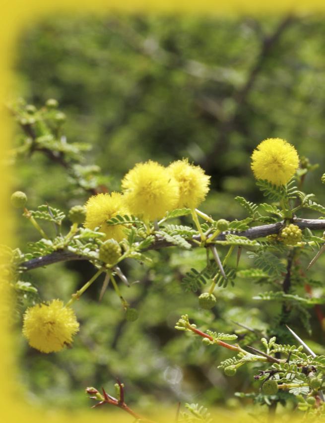
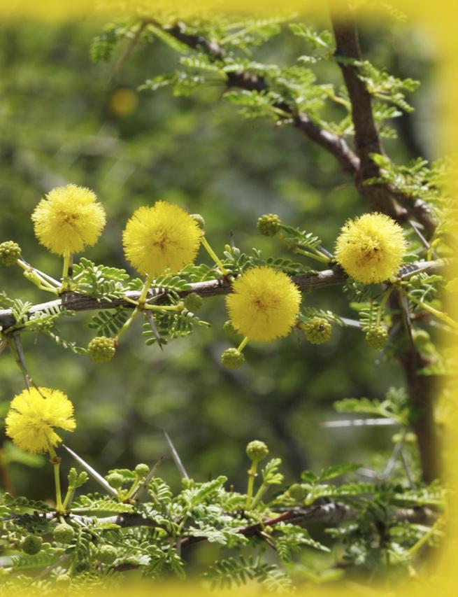
3 Jebel Al Akhdar Effects of Altitude and Grazing on Al Jebel Al Akhdar Sideroxylon mascatense on Al Jebel Al Akhdar Katja Brinkmann 1, Jens Gebauer 1, Annette Patzelt 2, Eva Schlecht 3 and Andreas Buerkert 1 Effects of Altitude and Grazing Intensity on Species Composition, Plant Diversity and Vegetation Structure on Al Jebel Al Akhdar The mountains of northern Oman host about 60% of the country s 1,200 species of vascular plants, of which 18 taxa are endemic. As compared to the foothills and central plains, the species diversity and the levels of endemism in this area are particularly high. A particularly interesting zone botanically within the area is the limestone massif of Al Jebel Al Akhdar (the Green Mountain), which forms the highest part of the Hajar range. The rangelands of Al Jebel Al Akhdar (1,580 2,000 metres) are characterised by semi-evergreen woodlands dominated by Sideroxylon mascatense growing in scattered mixed stands with Dodonaea, Euryops arabicus, 90 P r i d e

4 Olea europaea subsp. cuspidata and Sageretia thea. From heights of 2,000 metres to the summit, the vegetation is characterised by Juniperus excelsa subsp. polycarpos, Ephedra pachyclada. subsp. pachyclada and Teucrium mascatense. It has been suggested that the occurrence of Juniperus spp. and other plant associations in the Al Hajar range may be due to plant migrations from southeastern Iran across the Arabian Gulf. About 400 species of vascular plants are found in the Olea europaea and the Juniperus excelsa Takhtajan woodlands above altitudes of 1,500 Moringa peregrina is used traditionally in folk medicine and sold in local markets in Nizwa and Bahla, and the fruits of S. mascatense and Z. spina-christi are still collected by people and sold locally. vegetation changes along environmental gradients a case study The aim of this case study was to describe the species composition, diversity and stand structure of open woodlands on Al Jebel Al Akhdar along Stand structure of rangeland vegetation on a typical wadi (right) and a typical plateau site (left) on Al Jebel Al Akhdar. metres; however, the condition of the juniper trees is generally poor and regeneration is minimal, possibly reflecting the effects of increased grazing pressure by goat herds and feral donkeys. The wadi vegetation is of an azonal type, dependent on the prevailing water regime, and is highly influenced by man and livestock. The wadi fans consist mainly of gravel and sandy soil. Occasional rainfalls in winter can lead to flash floods that rush through the barren wadis. Acacia gerradii, Ziziphus spina-christi and Ficus cordata subsp. salicifolia are the major tree species present. Typical of the narrow wadi outlets of Al Jebel Al Akhdar range are shrubs such as Dyerophytum indicum, Nerium oleander and Pteropyrum scoparium. The stand structure present on the different topographic forms (slopes, ridges, dry wadis and water runnels) is highly variable. Wadi fans and plateau locations reveal the greatest variation in stand structure (see diagram above). Several species are of economic and medicinal value. The oil extracted from the seeds of altitudinal and grazing gradients (Brinkmann et al. 2007). The study was carried out on the common pastures of three villages, which are located within 10 kilometres of Sayh Qatanah, the central settlement of Al Jebel Al Akhdar mountains. The species compositions and several environmental variables such as browsing rate and distance to the settlement were investigated. Statistical analyses (cluster analysis and detrended correspondence analysis) revealed five different vegetation types along the environmental gradients, which were defined on the basis of the dominant species: The Sideroxylon mascatense Dodonaea viscosa group on grazed and the Olea europaea Fingerhuthia africana group on ungrazed plateau sites at 2,000 metres, the Ziziphus spina-cristi Nerium oleander group on wadi sites, the Moringa peregrina Pteropyrum scoparium group at 1,200 metres, and the Acacia gerrardii Leucas inflata group at 1,700 metres. The richness of plant species followed a unimodal distribution along the altitudinal gradient with the highest number at an altitude between 1,400 and 1,600 metres. The more balanced climate and the higher diversity of the topography in this zone probably accounted for the higher plant species numbers. 91


5 Grazing intensity decreased with increased distance from human settlements and with proximity to the steep, inaccessible slopes at the peripheries. Altogether 27% of the species showed a high degree of browsing damage. The highest browsing intensity was found on the Sayq plateau, reflected by the puny development of the ground layer and a severely impoverished species composition. A sharp decline in the populations of most palatable annual plant species, especially those of grasses, and the establishment of invasive species, such as Dodonaea viscosa and Euryops arabicus, was observed. found at the coolest site above 1,700 metres, while others only occurred at the warmer locations. A multilayered vegetation structure dominated with a canopy, an understory and a ground layer. Greatest species richness was recorded in the lowest stratum. Multicropping in small-scale agriculture creates favourable microclimates and often provides habitats for wild plants and animals. Remote Omani oases are not only a recently discovered important refuge for ancient wheat landraces (Al-Maskri et al. 2003, Zhang et al. 2006, Al Khanjari et al. 2007a,b) but also for indigenous wild plant Left: Olea europaea. subsp. cuspidata on Al Jebel Al Akhdar. the biodiversity of oasis farmland A surprisingly diverse mosaic of crops was found by studying two oasis settlements at Al Jebel Al Akhdar (Balad Sait and Al Ayn, Al Aqr and Ash Sharayjah). The genetic resources were assessed using a GIS-based field survey and farmer interviews (Gebauer et al. 2007). With a total of 92 different plant species, the number of crops was very high in comparison to other small-scale cropping systems under arid or semi-arid conditions. Fruits were the dominant use category with the highest number of species, followed by vegetables, cereals and medicinal plants. Some species, such as temperate fruits, were exclusively species, such as Epipactis veratrifolia. This orchid can be found in moist places in cliffs and along irrigation canals at an altitude of 450 to 2,000 metres, but it is threatened by habitat degradation and infrastructure development in Oman. Al Jebel Al Akhdar a local centre of plant endemism and biodiversity About 400 species of vascular plants are found in the Olea europaea subsp. cuspidata and the Juniperus excelsa woodland above 1,500 metres. Al Jebel Al Akhdar provides habitats for 62 species Right: Feral donkeys grazing in uncontrolled herds on common pastures at Al Jebel Al Akhdar. 92 P r i d e
.")
6 on the Oman Plant Red Data Book, representing 5.2% of the total flora and 15% of the flora of this mountain range. According to the most recent analysis of the endemic and threatened flora of the country, a total of 46 range-restricted species occur in this mountain range (3.8% of the total flora). Of the threatened non-endemic species, 15 occur in Al Jebel Al Akhdar (1.3% of the total flora) (Patzelt 2007), but remote parts of the northern mountains are yet to be investigated fully and future work will reveal more distribution data of threatened species and allow more precise estimates of population size for conservation action. grazing pressure. Future scientific work should attempt to better quantify the degradation stage and the regeneration ability of these unique ecosystems for the development of sustainable management strategies. Acknowledgements We are indebted to the Agricultural Extension Center of the Ministry of Agriculture and Fisheries at Sayh Qatanah for general information about the oases, and to Dr. Sulaiman Al Khanjari, Sultan Qaboos University, Muscat, for his friendship and support. We also wish to express our gratitude to the German Research Foundation (Deutsche Forschungsgemeinschaft) for funding. The traditional land-use management practices, which have been employed by the population, played a pivotal role in protection against overexploitation on Al Jebel Al Akhdar range. Many traditional land uses have either modified or completely abandoned in recent times and the most serious change has been caused by the dramatic increase in livestock numbers, which has resulted in the overgrazing of many plants and vegetation types. However, this degradation has not been well assessed in terms of area affected and environmental impact due to the absence of national survey and monitoring capacity in Oman. Large numbers of feral donkeys have seriously added to the overgrazing problem, and these herds urgently need to be controlled to reduce References Al Khanjari, S., Hammer, K., Buerkert, A. and Röder, M.S Molecular diversity of Omani wheat revealed by microsatellites: I. Tetraploid landraces. Genetic Resources and Crop Evolution 54, Al Khanjari, S., Hammer, K., Buerkert, A. and Röder, M.S Molecular diversity of Omani wheat revealed by microsatellites: II. Hexaploid landraces. Genetic Resources and Crop Evolution Al-Maskri, M., Nagieb, M., Hammer, K., Filatenko, A.A., Khan, I. and Buerkert, A A note about Triticum in Oman. Genetic Resources and Crop Evolution 50 (1), Brinkmann, K., Patzelt, A., Dickhoefer, U., Schlecht, E. and Buerkert, A Effects of altitude and grazing intensity on species composition, plant diversity and vegetation structure in the Al Jebel Al Akhdar mountain range of northern Oman. Plant Ecology (submitted). Gebauer, J., Luedeling, E., Hammer, K., Nagieb, M. and Buerkert, A Mountain oases in northern Oman: An environment for evolution and in situ conservation of plant Fruits of Ziziphus spina-christi and Morus nigra sold in a local market in northern Oman. 94
7
8
2018 STATUS OF RARE & THREATENED PLANTS OF JEBAL HAFIT
 2018 STATUS OF RARE & THREATENED PLANTS OF JEBAL HAFIT INTRODUCTION Jebal Hafit, due to its higher elevation (1,240 m above sea level) and hospitable climatic conditions, is floristically rich, with 209
Crete Study Site Description
 Crete Study Site Description 1. Location Crete (the largest island of Greece) is located in the south part of Greece covering an area of 8.335 km 2 or 6.3% of the Greek territory, including the surrounding
GEOGRAPHY AND HISTORY
 GEOGRAPHY AND HISTORY YEAR 1, PART 1 www.vicensvives.es Contents 01 Our planet Earth 02 The representation of the Earth: maps 03 The Earth s relief 04 Rivers and seas 05 Weather and climate 06 Climates
Region 1 Piney Woods
 Region 1 Piney Woods Piney Woods 1. This ecoregion is found in East Texas. 2. Climate: average annual rainfall of 36 to 50 inches is fairly uniformly distributed throughout the year, and humidity and temperatures
Biosphere Reserves of India : Complete Study Notes
 Biosphere Reserves of India : Complete Study Notes Author : Oliveboard Date : April 7, 2017 Biosphere reserves of India form an important topic for the UPSC CSE preparation. This blog post covers all important
photos Department of Environment and Conservation Biodiversity Conservation
 photos Department of Environment and Conservation Biodiversity Conservation EcoEducation - making the connections to biodiversity conservation Do you consider experiential learning of biodiversity in the
THE STATUS OF DORCAS GAZELLE IN ETHIOPIA
 THE STATUS OF DORCAS GAZELLE IN ETHIOPIA Paper presented in the second workshop on the conservation and restoration of Sahelo-Saharan Antelopes. 1-5 May 2003 by Mohammed Ali and Ababu Ange Zeleke May /
Hydrology of Yemen. Dr. Abdulla Noaman
 Hydrology of Yemen Dr. Abdulla Noaman INTRODUCTION Location and General Topography Yemen is located on the south of the Arabian Peninsula, between latitude 12 and 20 north and longitude 41 and 54east,
 AGREEMENT Between Director of the Białowieża National Park, based in Białowieża (Poland) and Director of the National Park Bialowieża Forest, based in Kamieniuki (Belarus) and Head Forester of the Białowieża
Land Use. Grasslands and Rangelands National Parks and Reserves. Thursday, October 9, 14
 Land Use Grasslands and Rangelands National Parks and Reserves MANAGING AND SUSTAINING GRASSLANDS Almost half of the world s livestock graze on natural grasslands (rangelands) and managed grasslands (pastures).
Chapter 17. North Africa, Southwest Asia and Central Asia
 Chapter 17 North Africa, Southwest Asia and Central Asia Chapter Objectives Describe the major landforms and natural resources of North Africa, Southwest Asia, and Central Asia. Discuss the climate and
ALBERTA S GRASSLANDS IN CONTEXT
 ALBERTA S GRASSLANDS IN CONTEXT GLOBAL GRASSLANDS 1 Temperate grasslands, located north of the Tropic of Cancer and south of the Tropic of Capricorn, are one of the world s great terrestrial biomes 2.
Flora Distribution Types and Migration of the Flora
 Flora The evolution of the flora and vegetation started at the end of the late glacial period, about 12,000 years BP (Before Present). The mountains became covered by sparse pine and birch woodlands and
Chapter 7: The Geography and Settlement of Egypt, Kush, and Canaan
 Chapter 7: The Geography and Settlement of Egypt, Kush, and Canaan Learning Target: I can explain how geography affected early settlement in Egypt, Kush, and Canaan. Ancient Egypt and the Middle East Can
ECORREGIONAL ASSESSMENT: EASTERN CORDILLERA REAL ORIENTAL PARAMOS AND MONTANE FORESTS
 ECORREGIONAL ASSESSMENT: EASTERN CORDILLERA REAL ORIENTAL PARAMOS AND MONTANE FORESTS The Nature Conservancy, EcoCiencia y Fundación AGUA. 2005. Evaluación Ecorregional de los Páramos y Bosques Montanos
What Is An Ecoregion?
 Ecoregions of Texas What Is An Ecoregion? Ecoregion a major ecosystem with distinctive geography, characteristic plants and animals, and ecosystems that receives uniform solar radiation and moisture Sometimes
Chapter 7 Geography and the Early Settlement of Egypt, Kush, and Canaan
 Chapter 7 Geography and the Early Settlement of Egypt, Kush, and Canaan How did geography affect early settlement in Egypt, Kush, and Canaan? Section 7.1 - Introduction RF/NASA//Corbis This satellite photograph
Current conditions. Guatemala's Maya Biosphere Reserve. No clear idea of speed of deforestation. Deforestion by pollen analysis
 Current conditions Most obvious human transformation is cutting of forests Guatemala's Maya Biosphere Reserve An Eco-Friendly Adventure Along the Maya Trails Key ecological roles: repository for biodiversity
Conservation Partners for the National Reserve System Program: a Western NSW focus
 Conservation Partners for the National Reserve System Program: a Western NSW focus Cooper, N. 1, Webber, L. 2, Nicolson, K. 3 1 Department of Environment, Climate Change and Water NSW, PO Box 788 Broken
Ex-Situ Conservation Site at Assam State Zoo cum Botanical Garden
 Ex-Situ Conservation Site at Assam State Zoo cum Botanical Garden The Government of India, in order to combat the adverse effects of climate change on the Himalayan states of India, introduced the National
Chapter 7. Geography and the Early Settlement of Egypt, Kush, and Canaan
 Chapter 7 Geography and the Early Settlement of Egypt, Kush, and Canaan Chapter 7 Geography and the Early Settlement of Egypt, Kush, and Canaan How did geography affect early in Egypt Kush, and Canaan?
3rd GRADE MINIMUM CONTENTS UDI 1: LANDSCAPES (5)
") 3rd GRADE MINIMUM CONTENTS UDI 1: LANDSCAPES (5) DIFFERENT LANDSCAPES A landscape is all the things that we see in a place. There are different types of landscapes. Mountain landscapes have mountains and
3rd GRADE MINIMUM CONTENTS UDI 1: LANDSCAPES (5) DIFFERENT LANDSCAPES A landscape is all the things that we see in a place. There are different types of landscapes. Mountain landscapes have mountains and
Ancient Egypt and the Near East
 *O*»f ' i ft Ancient Egypt and the Near East Chapter 7 Chapter 8 Chapter 9 Geography and the Early Settlement of Egypt, Kush, and Canaan The Ancient Egyptian P h a r a o h s Daily Life in Ancient Egypt
Mountains and Deserts of Oman Open Group Departure 23 rd April to 30 th April, 2017
 Mountains and Deserts of Oman Open Group Departure 23 rd April to 30 th April, 2017 This comprehensive guided tour of Oman visits the grand capital of Muscat, the remote mountain village of Misfah, historic
Pembina Valley Provincial Park. Draft Management Plan
 Pembina Valley Provincial Park Draft Management Plan 2 Pembina Valley Provincial Park Table of Contents 1. Introduction... 3 2. Park History... 3 3. Park Attributes... 3 3.1 Natural... 3 3.2 Recreational...
Terms to Know. artesian well coral atoll krill lagoon
 Chapter Objectives Describe the diverse landforms and natural resources of Australia, Oceania, and Antarctica. Discuss the wide range of climates and vegetation throughout the region. The Land Section
The forests of Mediterranean cypress in northern Africa can be
 Makhtar Cypress & Atlas Cypress Cupressus sempervirens var. numidica Trabut. Bou Abdallah Tunisia Cupressus atlantica Gaussen. Sidi Youssef ou Brahim Morocco The forests of Mediterranean cypress in northern
Brief Description of Northern the West Bank, Palestine Prepared by: Dr. Ahmed Ghodieh Department of Geography An-Najah National University Nablus,
 Brief Description of Northern the West Bank, Palestine Prepared by: Dr. Ahmed Ghodieh Department of Geography An-Najah National University Nablus, Palestine Brief Description of Northern the West Bank
You can learn more about the trail camera project and help identify animals at WildCam Gorongosa (
 INTRODUCTION Gorongosa National Park is a 1,570-square-mile protected area in Mozambique. After several decades of war devastated Gorongosa s wildlife populations, park scientists and conservation managers
Summary of prescribed fires in Prince Albert National Park 2015
 Summary of prescribed fires in Prince Albert National Park 2015 Prince Albert National Park conducted four controlled fires in spring 2015, plus an additional fire in October. Fuel Management for Hazard
STUDY GUIDE. The Land. Chapter 17, Section 1. There are frequent earthquakes in the region. Petroleum is a major export in the region.
 For use with textbook pages 421 426. The Land Terms to Know alluvial soil A rich soil made up of sand and mud deposited by flowing water (page 423) wadi A streambed that remains dry until a heavy rain
The Design of Nature Reserves
 The Design of Nature Reserves Goals Maintenance of MVP s for targeted species Maintenance of intact communities Minimization of disease Considerations of reserve design 1. Disturbance regime Fire Insect
Just how big is Africa?
 The United States China India The United Kingdom Portugal Spain France Belgium Germany The Netherlands Switzerland Italy Eastern Europe Japan 11.7 million sq. miles Just how big is Africa? Chapter 18 Section
The Impact of Human Activities on Plant diversity in Nanda Devi Biosphere Reserve, West Himalaya, India
 The Impact of Human Activities on Plant diversity in Nanda Devi Biosphere Reserve, West Himalaya, India 1. INTRODUCTION Biosphere Reserves are the areas having rich ecosystem which are nominated by National
Connecting Northern Tanzania
 Connecting Northern Tanzania A socio-economic comparison of the alternative routes for a highway from Arusha to Musoma by Frankfurt Zoological Society J. Grant C. Hopcraft (May, 2011) Tanzania s Road Network
8. VEGETATION AND FAUNA
 8. VEGETATION AND FAUNA 8.1 INTRODUCTION The original native vegetation within the Little River Catchment varied according to geology, soil type, moisture and depth, temperature, rainfall, fire regime,
ANAGEMENT. LAN November, 1996
 M ANAGEMENT P LAN November, 1996 for Paul Lake Provincial Park Ministry of Environment, Lands and Parks BC Parks Department Paul Lake Provincial Park M ANAGEMENT P LAN Prepared by BC Parks Kamloops Area
ENVIRONMENTAL PROFILE:
 Pyrenees Study Area for LEDDRA LOCATION: The Pyrenees study area is located in the Spanish Central Pyrenees (42º 36 N, 0º 00 E), in the Sobrarbe area (Huesca province, Aragón region). It includes the municipalities
The Roots of Carrying Capacity
 1 Applying Carrying Capacity Concepts in Wilderness 1872 1964...shall be preserved for the use & enjoyment of the American people...in such manner as will leave them unimpaired for future generations...
Case Study: 1. The Clarence River Catchment
 Case Study: 1. The Clarence River Catchment The NSW coastline is a great natural asset, making an enormous contribution to the economy. The resources of coastal catchments such as the Clarence River Catchment,
Spatial Distribution and Characteristics of At-Risk Species in the Southeast U.S.
 Nicholas Institute for Environmental Policy Solutions Scoping Document Part 2 Exploratory Analysis of Characteristics and Trends of At-Risk Species in the Southeast U.S. Spatial Distribution and Characteristics
Brain Wrinkles. Africa: The impact of location, climate, & physical characteristics on where people live, the type of work they do, & how they travel
 Africa: The impact of location, climate, & physical characteristics on where people live, the type of work they do, & how they travel STANDARDS: SS7G3 The student will explain the impact of location, climate,
Biodiversity Studies in Gorongosa
 INTRODUCTION Gorongosa National Park is a 1,570-square-mile protected area in Mozambique. Decades of war, ending in the 1990s, decimated the populations of many of Gorongosa s large animals, but thanks
Tour "Nizwa and Al Hamra"
 Travel proposition Tour "Nizwa and Al Hamra" Discovery self drive tour 1 day In the morning, visit Nizwa souq and fort. Then discover the Al Hamra region, with the picturesque village of Misfat al Abriyeen
سبل تفعيل تنفيذ ا تفاقية الا راضى الرطبة فى المنطقة العربية
 CONVENTION ON WETLANDS "RAMSAR" AND THE ARAB REGION سبل تفعيل تنفيذ ا تفاقية الا راضى الرطبة فى المنطقة العربية "رامسار" National Institute of Oceanography and Fisheries WETLANDS SERVICES AND PRODUCTS
Union of Myanmar Forest Department
 Union of Myanmar Forest Department Country Report for Regional Sharing Workshop on Assessment of Challenges and Opportunities in the Asia Pacific Region for RIO+20 INTRODUCTION 1. Country Profile Location
Coverage of Mangrove Ecosystem along Three Coastal Zones of Puerto Rico using IKONOS Sensor
 Coverage of Mangrove Ecosystem along Three Coastal Zones of Puerto Rico using IKONOS Sensor Jennifer Toledo Rivera Geology Department, University of Puerto Rico, Mayagüez Campus P.O. Box 9017 Mayagüez,
How should the proposed protected area be administered and managed?
 SPERRGEBIET CONSERVATION PLANNING Questionnaire In big words the main objectives of this questionnaire are to contribute to: 1. finding approaches and mechanism for implementing a multi-use protected area
The South Gippsland Koala. For over 60 years, the plantation industry has shared a unique relationship with the Strzelecki Koala. protection.
 The South Gippsland Koala For over 60 years, the plantation industry has shared a unique relationship with the Strzelecki Koala. protection harmony THE CO-EXISTENCE OF THE KOALA WITH THE PLANTATIONS co-existence
Blanco Creek Ranch Acres, Uvalde County, Texas
 Blanco Creek Ranch 1208.30 Acres, Uvalde County, Texas James King, Agent Office 432 426.2024 Cell 432 386.2821 James@KingLandWater.com Blanco Creek Ranch 1208.30 acres Uvalde County, Texas James King,
Significant Natural Area Assessment. Property Name: Hillend Station
 Private Bag 50072, Queenstown 9348, New Zealand QUEENSTOWN, 10 Gorge Road, Phone +64 3 441 0499, Fax +64 3 450 2223 WANAKA, 47 Ardmore Street, Phone +64 3 443 0024, Fax +64 3 450 2223 Significant Natural
Title/Name of the area: Chwaka Bay, Zanzibar
 Title/Name of the area: Chwaka Bay, Zanzibar Presented by: Dr. Charles Lugomela, Ag. Head, Department of Aquatic Sciences and Fisheries, University of Dar es Salaam, P.O. Box 35064 Dar es Salaam, Tanzania
UNIT 5 AFRICA PHYSICAL GEOGRAPHY SG 1 - PART II
 UNIT 5 AFRICA PHYSICAL GEOGRAPHY SG 1 - PART II III. CLIMATE & VEGETATION A. The four main climate zones are tropical wet, tropical wet/dry (split into monsoon & savanna), semiarid, and arid. Other climate
Muscat City Tour & the orient of fragrances
 Muscat City Tour & the orient of fragrances Full day city tour in Muscat & Amouage - house of perfume Tour start: at 09:00 h am from your hotel in Muscat Arabic/English speaking guide Visit to the Grand
Cheshire Ecology Ltd.
 Cheshire Ecology Ltd. What is an NVC Survey? 22 March 2014 1 Introduction A National Vegetation Classification (NVC) survey is a detailed botanical survey of a site. They are normally required for large
TOWPATH MOWING GUIDELINES
 TOWPATH MOWING GUIDELINES 24 September 2007 CONTENTS Introduction Scope and Status of Guidelines Influences on the Guidelines Health and Safety Biodiversity INTRODUCTION Towpath management is a key issue
Applying Carrying Capacity Concepts in Wilderness
 Applying Carrying Capacity Concepts in Wilderness...shall be preserved for the use & enjoyment of the American people...in such manner as will leave them unimpaired for future generations... CSS 490 Professor
Geoscape Toronto The Oak Ridges Moraine Activity 2 - Page 1 of 10 Information Bulletin
 About 13,000 years ago as the Laurentide Ice Sheet melted, glacial meltwater accumulated between the ice sheet and the Niagara Escarpment. This formed a lake basin into which gravel and sand were deposited.
1.15 TONGARIRO GEOTHERMAL FIELD. List of Geothermal Sites. Te Maari Craters. Emerald Lakes. Contract Report No. 2348
 1.15 TONGARIRO GEOTHERMAL FIELD List of Geothermal Sites TGV01 TGV02 TGV03 TGV04 Te Maari Craters Ketetahi Emerald Lakes Red Crater 2011 452 TGV01 Te Maari Craters 0508 WILDNZ www.wildlands.co.nz ± ± 0
Appendices A (Our ambition for nature (A3 plan) and further information)
 and further information)") Appendices A (Our ambition for nature (A3 plan) and further information) Penny Hill Farm Nature Conservation vision Key: Tenancy boundary Meadow restoration & Mowing/meadow F33 Mowing/meadow Progress towards
Appendices A (Our ambition for nature (A3 plan) and further information) Penny Hill Farm Nature Conservation vision Key: Tenancy boundary Meadow restoration & Mowing/meadow F33 Mowing/meadow Progress towards
Terrestrial Protected Area Nomination: Central Mangrove Wetland South-West, Grand Cayman
 Terrestrial Protected Area Nomination: Central Mangrove Wetland South-West, Grand Cayman The attached nomination, proposing that a parcel of land in the Central Mangrove Wetland be made a Protected Area
12 NIGHT/13 DAY FAMILY SAFARI NORTHERN TANZANIA
 12 NIGHT/13 DAY FAMILY SAFARI NORTHERN TANZANIA Day One - Lake Manyara On arrival into Kilimanjaro you are met and transferred directly to Lake Manyara National Park. Located 125 km west of Arusha town,
Maps and satellite images of Ngorongoro Conservation Area (World Heritage Site)
") Maps and Satellite Images of Ngorongoro Conservation Area Above: Location of the Ngorongoro Conservation Area in East Africa (from: www.africannaturalheritage.org) Right: Ngorongoro Conservation Area lies
Maps and Satellite Images of Ngorongoro Conservation Area Above: Location of the Ngorongoro Conservation Area in East Africa (from: www.africannaturalheritage.org) Right: Ngorongoro Conservation Area lies
2015 Brain Wrinkles. SS8G1b
 SS8G1b Georgia is a geographically diverse state that is divided into five regions. The first three regions (Appalachian Plateau, Valley and Ridge, and Blue Ridge) are in the mountains and foothills of
Trekking path to Mutrah or Riyam
 Mutrah Capital Area C38 Mutrah Capital Area C38 Al Musanaah Juzor ad Daymaniyat G U L F Barka As eeb Intl Airport Jamma Ar Rustaq Nakhal Bidbid O F O M A N AL HAJ A AR AL GHARBI Al Awabi amail Qurayyat
Wonders of Oman. 9 Days
 Wonders of Oman 9 Days Wonders of Oman Venture across the mesmerizing Sultanate of Oman, a hidden gem of the Middle East. Enjoy camel rides and encounter Bedouin tribes in the rolling dunes of the Wahiba
"ST. KLIMENT OHRIDSKI FACULTY OF GEOLOGY AND GEOGRAPHY
 SOFIA UNIVERSITY "ST. KLIMENT OHRIDSKI FACULTY OF GEOLOGY AND GEOGRAPHY APPLICATION OF THE MODEL "DRIVING FORCES PRESSURE STATE - RESPONSE FOR ASSESSMENT OF FLOOD RISK RADOSTINA BORISOVA DOCHEVA Bachelor
The Conservation Contributions of Ecotourism Cassandra Wardle
 The Conservation Contributions of Ecotourism Cassandra Wardle PhD Candidate, Gold Coast, Australia Supervisors: Ralf Buckley, Aishath Shakeela and Guy Castley State of the Environment State of the Environment
Data on Albanian Biodiversity and Mapping
 Data on Albanian Biodiversity and Mapping Petrit Hoda University of Tirana, Botanical Garden Albana Zotaj Academy of Sciences Institute of Geographical Studies Country profile Area 28748 km2 Population
Map 1.1 Wenatchee Watershed Land Ownership
 Map 1.1 Wenatchee Watershed Land Ownership Map 1.1 Wenatchee Watershed Land Ownership The Wenatchee watershed lies in the heart of Washington state in Chelan County. Just larger than the state of Rhode
Species: Wildebeest, Warthog, Elephant, Zebra, Hippo, Impala, Lion, Baboon, Warbler, Crane
 INTRODUCTION Gorongosa National Park is a 1,570-square-mile protected area in Mozambique. Decades of war, ending in the 1990s, decimated the populations of many of Gorongosa s large animals, but thanks
What is an Marine Protected Area?
 Policies, Issues, and Implications of Marine Protected Areas Kara Anlauf University of Idaho Before the House Subcommittee on Fisheries Conservation, Wildlife and Oceans April 29, 2003 What is an Marine
Exchange of Experiences: Natural World Heritage sites. Sri Lanka. S.I Rajapakse, Assistant Director Ministry of Mahaweli Development and Environment
 Exchange of Experiences: Natural World Heritage sites Sri Lanka S.I Rajapakse, Assistant Director Ministry of Mahaweli Development and Environment Natural Sites Sinharaja Forest Reserve Central Highlands
2017 IKA FORMULA KITE WORLD CHAMPIONSHIPS MUSCAT, SULTANTE OF OMAN
 2017 IKA FORMULA KITE WORLD CHAMPIONSHIPS MUSCAT, SULTANTE OF OMAN Information: The Sultanate of Oman combines sea, mountains, desert, ancient culture and contemporary cosmopolitism with a warm welcome.
Investigation on Development of Agricultural Monitoring System Using Satellite Data
 Investigation on Development of Agricultural Monitoring System Using Satellite Data Genya SAITO (1), Daisuke KUNII (1), Naoki ISHITSUKA (2) (1) Tohoku University, 1-1,Tsutsumidori Amamiya-machi Aoba-ku,
2.1 What is the climate like?
 José Medeiros This fact sheet allows you to see how varied the countryside is across Brazil. 2.1 What is the climate like? Most of Brazil is in the Southern Hemisphere, where the seasons are the opposite
Yorkshire Dales classification of protected areas into IUCN Management Categories. Mark Fisher, November 2013 Wildland Research Institute
 Yorkshire Dales classification of protected areas into IUCN Management Categories Mark Fisher, November 2013 Wildland Research Institute Ingleborough National Nature Reserve Nesting of protected areas
MINIMUM REQUIREMENTS DECISION GUIDE WORKSHEETS
 ARTHUR CARHART NATIONAL WILDERNESS TRAINING CENTER MINIMUM REQUIREMENTS DECISION GUIDE WORKSHEETS Prescribed burning of islands within Okefenokee Wilderness Area.... except as necessary to meet minimum
STUDY GUIDE. The Land. Chapter 20, Section 1. The Land of Africa South of the Sahara. Landforms Water Systems Natural Resources.
 For use with textbook pages 499 504. The Land Terms to Know escarpment A steep, often jagged slope or cliff (page 500) cataract A towering waterfall (page 500) rift valley A large crack in the earth s
Mackinnon Esker Ecological Reserve Draft - Management Plan
 Mackinnon Esker Ecological Reserve Draft - Management Plan May 2011 Photo Credit: This document replaces the direction provided in the Carp Lake Provincial Park and Protected Area and Mackinnon Esker Ecological
2.0 Physical Characteristics
 _ 2.0 Physical Characteristics 2.1 Existing Land Use for the Project The site is comprised of approximately 114 acres bounded by Highway 101 to the north, the existing town of Los Alamos to the east, State
Designated Sites. Headlines
 Designated Sites Headlines Over 36% of the Sheffield district is covered by sites with European, national or local designation. These offer valuable habitats to wildlife, with some level of protection,
Regional impacts and vulnerability mountain areas
 Regional impacts and vulnerability mountain areas 1 st EIONET workshop on climate change vulnerability, impacts and adaptation EEA, Copenhagen, 27-28 Nov 2007 Klaus Radunsky 28 Nov 2007 slide 1 Overview
Order of the Minister of Environment #39, August 22, 2011 Tbilisi
 Registration Code 360050000.22.023.016080 Order of the Minister of Environment #39, August 22, 2011 Tbilisi On preparatory stages and procedure of the methodology for Elaborating structure, content and
IMPACTS OF THE RECENT TSUNAMI ON THE BUNDALA NATIONAL PARK THE FIRST RAMSAR WETLAND IN SRI LANKA
 IMPACTS OF THE RECENT TSUNAMI ON THE BUNDALA NATIONAL PARK THE FIRST RAMSAR WETLAND IN SRI LANKA by C.N.B. Bambaradeniya, IUCN The World Conservation Union, Sri Lanka Country Office (Email: cnb@iucnsl.org)
Highlights of Oman 10 days & 9 nights
 Highlights of Oman 10 days & 9 nights Day 1 Arrive Muscat You will be met on arrival in Muscat and transferred to the Ruwi Hotel, or similar, where you stay one night. Day 2 Muscat City tour After breakfast,
Water resource situation of the Republic of Djibouti
 Water resource situation of the Republic of Djibouti Omar ASSOWE DABAR Integrating Groundwater Management within River Basins 15-17 January 2019 Nairobi, Kenya Regional Training Workshop on Introduction
Marchand Provincial Park. Management Plan
 Marchand Provincial Park Management Plan 2 Marchand Provincial Park Table of Contents 1. Introduction... 3 2. Park History... 3 3. Park Attributes... 4 3.1 Natural... 4 3.2 Recreational... 4 3.3 Additional
South Texas Plains. Texas, Our Texas
 South Texas Plains This is a region characterized by considerable variety. Climatically, the South Texas Plains region is sub-humid to dry. The in the north part of the South Texas, erosion of the Edwards
Objective. Students will familiarize themselves with the physical features and climates of Latin America.
 Journal Write KWL What do you KNOW about Latin America? What do you WANT TO KNOW about Latin America? What did you LEARN today that you didn t know before? Latin America Objective Students will familiarize
Day 1 Muscat. Upon arrival in Muscat you will be met and transferred to the hotel. Accommodations: Chedi Hotel. Day 2 Muscat
 A journey through Oman offers a glimpse into a country where the desert evokes images of Arabia as told in the fabled stories of One Thousand and One Nights, where the unspoiled beaches stretch for hundreds
Assessing and Protecting the World s Heritage. Assessing and Protecting the World s Heritage
 Assessing and Protecting the World s Heritage NEFA BACKGROUND PAPER Assessing and Protecting the World s Heritage Prepared by: Dailan Pugh, 2014 With the NSW opposition parties threatening to open up the
Land Figures & Spatial Data Infrastructure in KOSOVO
 Land Figures & Spatial Data Infrastructure in KOSOVO Idriz SHALA idriz.shala@gmail.com GIS -expert Afrim SHARKU afrim.sharku@gmail.com Land Management - Expert Kick-off meeting of the Regional Expert Advisory
MAPs sector in Bosnia and Herzegovina
 MAPs sector in Bosnia and Herzegovina CEDDEM Decembre 2016 Bosnia & Herzegovina Official Name: Bosnia and Herzegovina (BH) Political system: Parliamentary democracy with a bicameral parliament; BH is composed
MANAGEMENT DIRECTION STATEMENT
 Lower Mainland District MAAGEMET DIRECTIO STATEMET January 2001 for Liumchen Ecological Reserve Ministry of Environment Lands and Parks BC Parks Division Table of Contents Page Introduction... 1 Purpose
AMENDMENT NO. 03 TO THE OFFICIAL PLAN FOR THE TOWNSHIP OF ADJALA-TOSORONTIO OAK RIDGES MORAINE CONSERVATION PLAN
 AMENDMENT NO. 03 TO THE OFFICIAL PLAN FOR THE TOWNSHIP OF ADJALA-TOSORONTIO OAK RIDGES MORAINE CONSERVATION PLAN Adopted by Council July 19 th, 2004 Approved with modifications by the Province of Ontario
BOTSWANA AGRICULTURAL CENSUS REPORT 2015
 BOTSWANA AGRICULTURAL CENSUS REPORT 2015 STATISTICS BOTSWANA BOTSWANA AGRICULTURAL CENSUS REPORT 2015 1 BOTSWANA AGRICULTURAL CENSUS REPORT 2015 2 BOTSWANA AGRICULTURAL CENSUS REPORT 2015 BOTSWANA AGRICULTURAL
BEFORE PROJECT THE BEGINNING
 BEFORE PROJECT THE BEGINNING SWBNP is a final sample of the former Lakes of Danube. On an area of 241 km2, PN-BmB retain 10% of the former Inland River Delta, the former Lake of Brăila and Ialomiţei, who
Geography of Qatar. Contents. State Borders. al-khor, Qatar. Photo Flickr. Loading index...
 Geography of Qatar al-khor, Qatar. Photo Flickr Contents Loading index... State Borders The small (sub)peninsula of Qatar is about 160 kilometres in length and between 55 and 90 kilometres in width. Its
Plant Conservation Efforts in Peninsular Malaysia
 Plant Conservation Efforts in Peninsular Malaysia Saw Leng Guan Forest Research Institute Malaysia Kepong, Malaysia International Symposium on Southeast Asian Tropical Forest Research Related to Climate